Presented by: Connie Perkins, PE, CFM April 20, 2016
|
|
|
- Ezra Bond
- 5 years ago
- Views:
Transcription


1 Presented by: Connie Perkins, PE, CFM April 20, 2016
2 City of Sacramento s Flood History Need for a Comprehensive Flood Management Plan (CFMP) Overview of Sacramento s CFMP 2016 Next Steps
3
4


5 Sacramento has experienced great floods events in 1860, 1911, 1913, 1950, 1955, 1963, 1964, 1986, 1995 and 1997
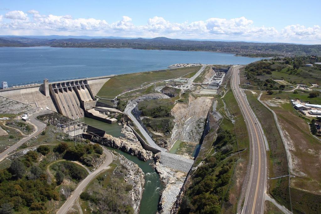
6 1956 Record Flood: Though engineers had been predicting it would take a year to fill the nearly completed upstream Folsom Dam, the second record storm filled the dam in a week and Sacramento is saved from flooding Record Flood: The 3rd record flood in less than 15 years. Engineers concluded that Folsom Dam was only designed to handle is a 120-yr storm, not a 500-yr storm Record Flood: 10 in. of rain in 11 days. Folsom Dam downgraded to about a 60-year storm. Corps determines that a majority of the city does not have 100-year protection.
7
8
9


10
11 Proposed Change to State Hazard Mitigation Plans to Address Future Climate Variability Issues (2014) E The Federal Flood Risk Management Standard for federal agencies (2015) Central Valley Flood Protection Plan SB5 (2016) New Development standard 200-year flood ULDC
12 City s strategic plan to reduce flood risk over the next 5 years. A comprehensive management document that will guide the City s flood risk reduction and mitigation efforts.
13 LOW RISK HIGH RISK Flood risk reduction is best achieved by employing a suite of risk reduction tools. LAND USE PLANNING FLOOD RISK REDUCTION DEV STANDARDS EMERGENCY PREP LEVEE IMP INTERNAL DRAINAGE RISK COMMUNICATION NFIP/CRS RISK REDUCTION TOOLS
14 Purpose Historical Perspective Land Use Planning and Development Guidelines Emergency Preparation Levee and Other Structural Improvements Internal Drainage Risk Communication National Flood Insurance Program (NFIP)/Community Rating System Program (CRS)
; Identification of refuge and evacuation locations for special needs facilities, new residential developments, large commercial and public buildings Rescue and Evacuation Zones")
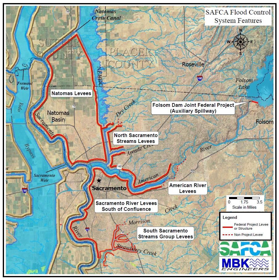
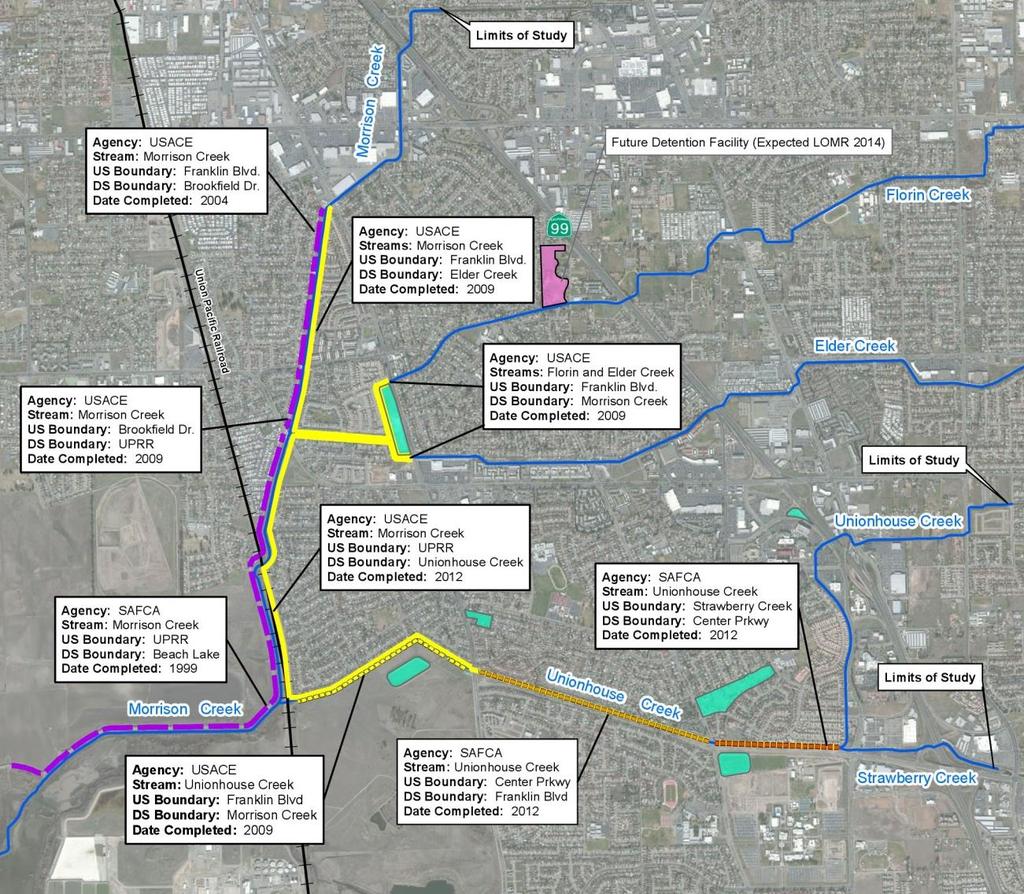
15 Rescue Zones Evacuation Plans for special needs facilities (schools, hospitals etc.); Identification of refuge and evacuation locations for special needs facilities, new residential developments, large commercial and public buildings Rescue and Evacuation Zones Identification of emergency vehicle access to subdivisions Provision of infrastructure to protect on-site fuel storage.

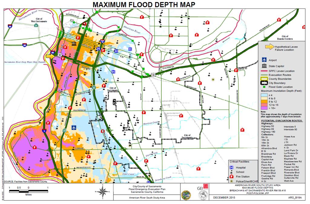
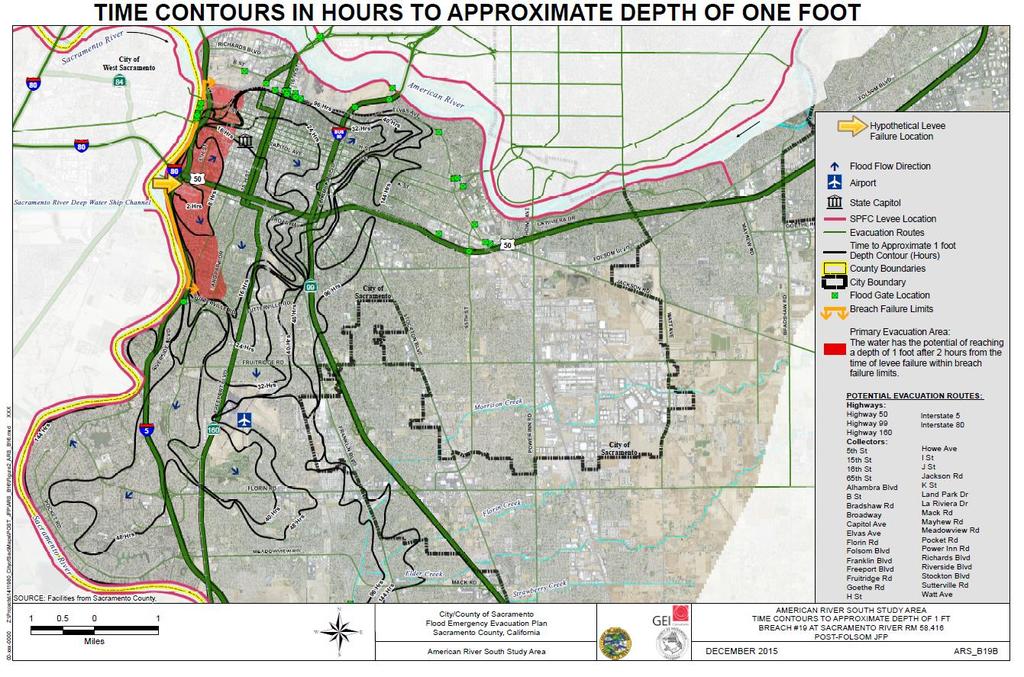
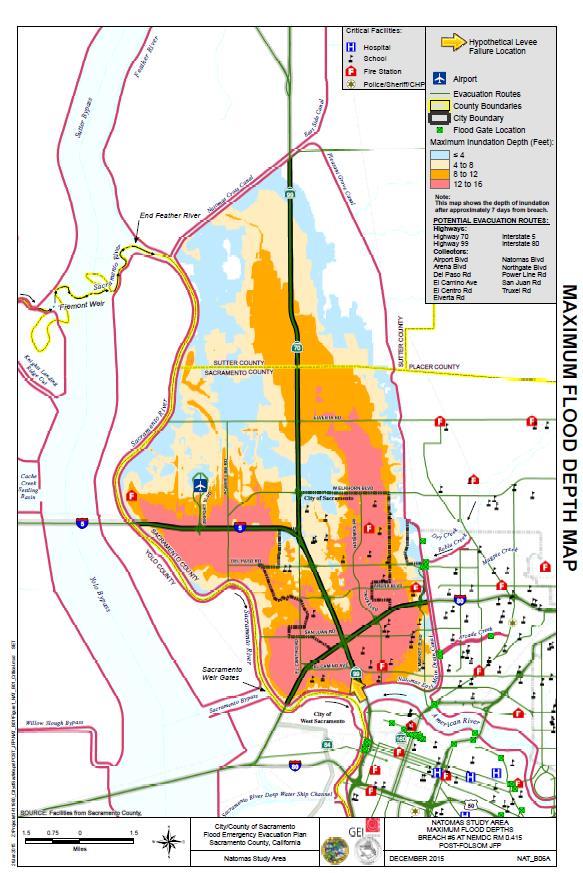
16 Rescue Zone: An area of the City that would flood to a depth of 1 foot in 2 hours.

17 Central Valley Flood Protection Plan (CVFPP) Requirements 200-year flood protection by July 2016 Levee clearance, encroachments, and maintenance requirements New state building code standards for evacuation

18 1 8

19 Connecting all emergency response documents Emergency Action Plans separate Response Everbridge System Critical Facilities List Observation & Recording Flooded Areas Recovery Plan Damage Assessment Recovery Ordinance Rescue & Evacuation Maps Based on 200-year flood State requirement Animated levee break scenarios
20
21
22

23 Major projects(corps, SAFCA, & DWR): American River Common Features Project Sacramento Urban Area Levee Reconstruction Project South Sacramento Stream Groups Folsom Dam Modifications/Joint Federal Project Natomas Levee Improvement Project
24


25 42 miles total 18 miles completed 24 miles to finish
26

27 Levee Accreditation Plan Corps expired the City s certifications 5 to 7 years Levee Modernization Plan 200-year plan
28 Since 1955, most of the City s flood damage has resulted from drainage deficiencies 1,354 miles of storm drain pipes; 49,914 drain inlets; and 105 pump stations The drainage system is sized based on outdated hydrology and does not have capacity to drain a 100-year storm event Approximately $70 million of the highest priority projects have been completed over the last 11 years, but a backlog of over $500 million in projects remains

29 City/County Watershed Management Plan (WMP) Reducing the increased flooding from development on watershed-wide basis


30 Brochure in City s Utility Bill annually Mailing to Repetitive Loss properties State of CA s Flood Risk Notice to 200-yr floodplain properties Billboards, advertisements on buses, community meetings and events High Water Mark Signs
31 Program For Public Information Flood Response Plan Flood Insurance Coverage Improvement Plan Repetitive Loss Area Analysis Community Rating System (CRS)Credit


32 Flood insurance 43,000 policies CRS Rating of 5 Equals a 10-25% reduction in flood insurance rates Equals a savings of $1.3 million/yr to the community
33 Adopt 2016 CFMP May 3, 2016 Initiate annual implementation program Future updates every 5 years

34 Connie Perkins, PE, CFM Senior Engineer
SUBJECT: EXECUTIVE DIRECTOR'S REPORT FOR JANUARY 19, 2017 WATER INFRASTRUCTURE IMPROVEMENTS FOR THE NATION (WIIN) ACT
 ACT") ITEM 2 Agenda of January 19, 2017 TO: FROM: Board of Directors Sacramento Area Flood Control Agency Richard M. Johnson, Executive Director (916) 874-7606 SUBJECT: EXECUTIVE DIRECTOR'S REPORT FOR JANUARY
ITEM 2 Agenda of January 19, 2017 TO: FROM: Board of Directors Sacramento Area Flood Control Agency Richard M. Johnson, Executive Director (916) 874-7606 SUBJECT: EXECUTIVE DIRECTOR'S REPORT FOR JANUARY
RECOMMENDATION: Staff recommends the Board adopt Resolution No approving SAFCA s Fiscal Year Final Budget.
 ITEM 5 Agenda of August 18, 2016 TO: FROM: SUBJECT: Sacramento Area Flood Control Agency Board of Directors Jason D. Campbell, Deputy Executive Director (916) 874-7606 APPROVING FINAL FISCAL YEAR 2016-17
Community Development Department
 Community Development Department Ryan DeVore, Interim Director of Community Development Scot Mende, Principal Planner Bill Busath, Interim Director of Utilities Connie Perkins, Senior Engineer, Floodplain
DES MOINES CITY OF TWO RIVERS. Flooding Risk & Impact to Development
 DES MOINES CITY OF TWO RIVERS Flooding Risk & Impact to Development River System Des Moines Flood Protection Des Moines Flood Protection cont. Infrastructure Over 24 miles of levees 21stormwater pump stations
SUBJECT: EXECUTIVE DIRECTOR'S REPORT FOR AUGUST 20, 2015
 ITEM 1 TO: FROM: Board of Directors Sacramento Area Flood Control Agency Richard M. Johnson, Executive Director (916) 874-7606 SUBJECT: EXECUTIVE DIRECTOR'S REPORT FOR AUGUST 20, 2015 SAFCA Intent to Serve
RESOLUTION - APPROVING FINAL FISCAL YEAR BUDGET
 ITEM 12 TO: FROM: SUBJECT: Sacramento Area Flood Control Agency Board of Directors Richard M. Johnson, Executive Director (916) 874-7606 RESOLUTION - APPROVING FINAL FISCAL YEAR 2015-16 BUDGET OVERVIEW:
FREQUENTLY ASKED QUESTION ABOUT FLOODPLAINS Michigan Department of Environmental Quality
 FREQUENTLY ASKED QUESTION ABOUT FLOODPLAINS Michigan Department of Environmental Quality WHAT IS A FLOOD? The National Flood Insurance Program defines a flood as a general and temporary condition of partial
CITY OF PLANTATION ENGINEERING DEPARTMENT INTEROFFICE MEMORANDUM NO
 CITY OF PLANTATION ENGINEERING DEPARTMENT INTEROFFICE MEMORANDUM NO. 2013-003 DATE: October 22, 2012 TO: Mayor and Members of City Council FROM: Brett W. Butler, PE, CFM City Engineer SUBJECT: CRS Program
Development Fee Program: Comparative risk analysis
 Development Fee Program: Comparative risk analysis January 2008 Sacramento Area Flood Control Agency David Ford Consulting Engineers, Inc. 2015 J Street, Suite 200 Sacramento, CA 95811 Ph. 916.447.8779
Floodplain Management Plan
 Floodplain Management Plan CITY OF FORT WORTH TFMA 2016 Spring Conference March 10, 2016 Agenda 1. Fort Worth Higher Standards (NFIP & CRS) 2. Floodplain Management Plan Overview and Results 3. Project
SUBJECT: LAND USE PLANNING POLICY WITHIN THE 100 YEAR FLOODPLAIN (REPORT #2)
") DEPARTMENT OF PLANNING AND DEVELOPMENT City Council Sacramento, California Honorable Members in Session: CITY OF SACRAMENTO CALIFORNIA August 20, 1993 1231 1 STREET ROOM 200 SACRAMENTO, CA 95814-2998 ENVIRONMENTAL
DEPARTMENT OF PLANNING AND DEVELOPMENT City Council Sacramento, California Honorable Members in Session: CITY OF SACRAMENTO CALIFORNIA August 20, 1993 1231 1 STREET ROOM 200 SACRAMENTO, CA 95814-2998 ENVIRONMENTAL
MUNICIPAL LAND USE STRATEGIES for Improving Flood Resilience
 MUNICIPAL LAND USE STRATEGIES for Improving Flood Resilience Strategy for a Flood Resistant Southern Tier Central Region (LWRP project) This presentation was prepared by Southern Tier Central Regional
Action Items for Flood Risk Management on Wildcat Creek Interagency success with floodplain management plans and flood forecast inundation maps
 Presentation to USACE 2012 Flood Risk Management and Silver Jackets Joint Workshop, Harrisburg, Pennsylvania Action Items for Flood Risk Management on Wildcat Creek Interagency success with floodplain
Justification for Floodplain Regulatory Standards in Illinois
 Justification for Floodplain Regulatory Standards in Illinois Office of Water Resources Issue Paper April, 2015 Proactive Illinois floodplain and floodway regulatory standards have prevented billions of
Repetitive Loss Area Revisit # 6 Walter Road Area Jefferson Parish
 Repetitive Loss Area Revisit # 6 Walter Road Area Jefferson Parish www.floodhelp.uno.edu Supported by FEMA Acknowledgement The compilation if this report was managed by Erin Patton, CFM, a UNO-CHART Research
Michael Taylor, PE, CFM Project Manager, AECOM August 25, 2015
 Promoting FEMA s Flood Risk Products in the Lower Levisa Watershed Michael Taylor, PE, CFM Project Manager, AECOM August 25, 2015 Agenda Study Background Flood Risk Product Overview AOMI and Mitigation
A Review of Our Legacy System, History of Neglect, Current Issues, and the Path Forward for Levee Safety
 4 th NACGEA GEOTECHNICAL WORKSHOP January 29, 2010 A Review of Our Legacy System, History of Neglect, Current Issues, and the Path Forward for Levee Safety Presented by: Leslie F. Harder, Jr., Phd, PE,
Flood Hazards and Flood Risk, the Impact of a Changing Climate
 Flood Hazards and Flood Risk, the Impact of a Changing Climate Sally A. McConkey, P.E. CFM, D. WRE. Illinois State Water Survey June 14, 2017 Topics ISWS Coordinated Hazard Assessment and Mapping Program
10/5/2015. What Makes a Sound Floodplain Management Program? What are the Flood Problems in your Community?
 The Community Rating System (CRS) and Hazard Mitigation Planning Preparing Your Community Through Common Program Goals September 3, 2015 What Makes a Sound Floodplain Management Program? Know your community
Non Regulatory Risk MAP Products Flood Depth and Probability Grids
 Non Regulatory Risk MAP Products Flood Depth and Probability Grids Virginia Floodplain Management Association 2015 Floodplain Management Workshop October 29th, 2015 Nabil Ghalayini, P.E., PMP, D.WRE, CFM
Comprehensive Flood Management Plan. City of Sacramento Department of Utilities
 Comprehensive Flood Management Plan City of Sacramento Department of Utilities City of Sacramento Department of Utilities Prepared by: Connie Perkins, City of Sacramento, Department of Utilities Kelly
Flood Plain Management Services (FPMS) Program
 Program") Flood Plain Management Services (FPMS) Program 2016 Winter Stakeholder Partnering Forum March 2016 Mario Beddingfield, P.E., CFM Hydraulic Engineer/FPMS Program Manager H&H/Water Control Branch U.S. Army
Flood Plain Management Services (FPMS) Program 2016 Winter Stakeholder Partnering Forum March 2016 Mario Beddingfield, P.E., CFM Hydraulic Engineer/FPMS Program Manager H&H/Water Control Branch U.S. Army
Upper Joachim Creek Public Survey on Potential Flood Risk Reduction
 Upper Joachim Creek Public Survey on Potential Flood Risk Reduction This survey is intended to help the interagency planning committee to receive public feedback on specific flood risk reduction techniques,
Flood Risk Management and Nonstructural Flood Risk Adaptive Measures
 Flood Risk Management and Nonstructural Flood Risk Adaptive Measures Randall Behm, P.E., CFM USACE-Omaha District Chair, National Nonstructural Flood Proofing Committee US Army Corps of Engineers BUILDING
3D Elevation Program (3DEP) Status and Plans. Kevin T. Gallagher Associate Director, Core Science Systems June 26, 2017
 Status and Plans. Kevin T. Gallagher Associate Director, Core Science Systems June 26, 2017") + 3D Elevation Program (3DEP) Status and Plans Kevin T. Gallagher Associate Director, Core Science Systems June 26, 2017 + 2 3D Elevation Program (3DEP) Apply lidar technology to map bare earth and 3D
+ 3D Elevation Program (3DEP) Status and Plans Kevin T. Gallagher Associate Director, Core Science Systems June 26, 2017 + 2 3D Elevation Program (3DEP) Apply lidar technology to map bare earth and 3D
ANNUAL REPORT. on the MITIGATION ACTIONS. in the SACRAMENTO COUNTY LOCAL HAZARD MITIGATION PLAN Dated December 2016 (AND FLOODPLAIN MANAGEMENT PLAN)
") ATTACHMENT 4 ANNUAL REPORT on the MITIGATION ACTIONS in the SACRAMENTO COUNTY LOCAL HAZARD MITIGATION PLAN Dated December 2016 (AND FLOODPLAIN MANAGEMENT PLAN) Adopted County Board of Supervisors on July
ATTACHMENT 4 ANNUAL REPORT on the MITIGATION ACTIONS in the SACRAMENTO COUNTY LOCAL HAZARD MITIGATION PLAN Dated December 2016 (AND FLOODPLAIN MANAGEMENT PLAN) Adopted County Board of Supervisors on July
East Hartford. Challenges
 East Hartford The Town of East Hartford is a suburban community of approximately 52,212 located east of the City of Hartford and west of the Town of Manchester. The Town covers slightly more than 18 square
Community Rating System. National Flood Insurance Program
 National Flood Insurance Program Community Rating System A Local Official s Guide to Saving Lives Preventing Property Damage Reducing the Cost of Flood Insurance FEMA B-573 / May 2015 How the Community
Flood Risk in the Schuylkill Watershed. Planning for Resilient Communities
 Flood Risk in the Schuylkill Watershed Planning for Resilient Communities Welcome to Our Poster Session! We are here to talk about: Flood Risk in the Schuylkill River Watershed Taking Action to Reduce
FEMA FLOOD MAPS Public Works Department Stormwater Management Division March 6, 2018
 FEMA FLOOD MAPS Public Works Department Stormwater Management Division March 6, 2018 Presentation Overview FEMA National Flood Insurance Program (NFIP) FEMA Community Rating System (CRS) Flood Insurance
GENERAL PLAN AMENDMENT # FLOOD HAZARDS
 GENERAL PLAN AMENDMENT #2011-03 FLOOD HAZARDS The following text that appears on pages HS 3-4 of the Health and Safety Element in the Yolo 2030 Countywide General Plan has been amended. New language is
Using GISWeb to Determine Your Property s Flood Zone
 Using GISWeb to Determine Your Property s Flood Zone 1. In a new browser window, go to http://www.co.santacruz.ca.us/departments/geographicinformationsystemsgis.aspx 2. Click on GISWeb - GIS Mapping Application
CITY OF VESTAVIA HILLS
 CITY OF VESTAVIA HILLS FLOODPLAIN MANAGEMENT PLAN KICK-OFF MEETING MARCH 10, 2015 FLOODPLAIN MANAGEMENT PLANNING COMMITTEE Representative of the following categories Preventive Maintenance (e.g., codes)
Abstract. An assessment of the benefits of DWR s levee inspection program in California s Central Valley
 An assessment of the benefits of DWR s levee inspection program in California s Central Valley At left: Crew members place sandbags during flood fighting effors (DWR). By David Ford, PhD, PE, D.WRE; Joanna
Bucks County, PA Flood Risk Review Meeting. November 2014
 Bucks County, PA Flood Risk Review Meeting November 2014 Agenda for Today Risk MAP Program overview Overview of non-regulatory Flood Risk Products and datasets Discuss mitigation action Technical overview
Delaware River Basin Commission s Role in Flood Loss Reduction Efforts
 Delaware River Basin Commission s Role in Flood Loss Reduction Efforts There is a strong need to reduce flood vulnerability and damages in the Delaware River Basin. This paper presents the ongoing role
Green Stormwater. Flood Risk Reduction. Infrastructure for. June Presented by: Kari Mackenbach, CFM ms consultants Lynn Mayo, PE, CFM AECOM
 Green Stormwater Infrastructure for Flood Risk Reduction June 2016 Presented by: Kari Mackenbach, CFM ms consultants Lynn Mayo, PE, CFM AECOM Topics 1. Proposed ASFPM Policy Paper 2. Background Why is
Technical Memorandum 3.4 E Avenue NW Watershed Drainage Study. Appendix E Floodplain Impacts and Implications Memo
 Technical Memorandum 3.4 E Avenue NW Watershed Drainage Study Appendix E Floodplain Impacts and Implications Memo September 8, 2017 City of Cedar Rapids E Avenue Watershed Drainage Study Memo Date: Tuesday,
YUNG-HSIN SUN Ph.D., P.E., D.WRE
 YUNG-HSIN SUN Ph.D., P.E., D.WRE Corresponding roles and responsibilities depend on levee ownerships, agreements, and interests Local Maintaining Agencies State s role is increasing and its jurisdiction
Thurston County, WA Flood Hazard Mitigation Plan Annual Progress Report CRS Activity 510
 Thurston County, WA Flood Hazard Mitigation Plan Annual Progress Report CRS Activity 510 Reporting Period: ctober 1, 2014 to September 30, 2015 Background: Thurston County developed a flood hazard mitigation
COUNTY OF SACRAMENTO CALIFORNIA
 COUNTY OF SACRAMENTO CALIFORNIA Control No.: 2002-0105 Type: GPB A D D E N D U M # 4 For the Agenda of: July 20, 2010 Agenda Item No. 4 TO: FROM: BOARD OF SUPERVISORS PLANNING AND COMMUNITY DEVELOPMENT
Planning Process---Requirement 201.6(b): An open public involvement process is essential to the development of an effective plan.
: An open public involvement process is essential to the development of an effective plan.") Section 3 Capability Identification Requirements Planning Process---Requirement 201.6(b): An open public involvement process is essential to the development of an effective plan. Documentation of the Planning
Section 3 Capability Identification Requirements Planning Process---Requirement 201.6(b): An open public involvement process is essential to the development of an effective plan. Documentation of the Planning
CRS UNIFORM MINIMUM CREDIT NEW JERSEY
 CRS UNIFORM MINIMUM CREDIT NEW JERSEY SUMMARY The Community Rating System (CRS) provides Uniform Minimum Credit (UMC) for certain state laws, regulations, and standards that support floodplain management
A Flood Mitigation Plan for the Non-Tidal N.J. Section of the Delaware River Basin. Warren County Planning Workshop (2 nd Meeting) March 7, 2007
 March 7, 2007") A Flood Mitigation Plan for the Non-Tidal N.J. Section of the Delaware River Basin Warren County Planning Workshop (2 nd Meeting) March 7, 2007 Study Area Participation: Hunterdon: 16 Eligible Municipalities
A Flood Mitigation Plan for the Non-Tidal N.J. Section of the Delaware River Basin Warren County Planning Workshop (2 nd Meeting) March 7, 2007 Study Area Participation: Hunterdon: 16 Eligible Municipalities
Flood Risk Outreach Tools for Georgia Communities. GAFM 10 th Annual Conference Presented By: Jarrett Mattli
 Flood Risk Outreach Tools for Georgia Communities GAFM 10 th Annual Conference Presented By: Jarrett Mattli April 13, 2016 Presentation Overview Guidebooks Toolkits Templates Educational Videos Resource
REAL ESTATE FLOOD DISCLOSURE PROGRAM & FLOOD MAP INFORMATION SERVICES
 REAL ESTATE FLOOD DISCLOSURE PROGRAM & FLOOD MAP INFORMATION SERVICES Lisa Foster, CFM, Floodplain Coordinator ldfoster@pinellascounty.org January 26, 2018 Why are you here? Save your clients money on
Kentucky Division of Water Permitting Floodplain Overview and Considerations
 Kentucky Division of Water Permitting Floodplain Overview and Considerations Presentation to: 2014 KAMM Conference Lake Barkley State Resort Park by Solitha Dharman Department for Environmental Protection
BUTTS COUNTY, GEORGIA AND INCORPORATED AREAS
 BUTTS COUNTY, GEORGIA AND INCORPORATED AREAS Butts County Community Name Community Number BUTTS COUNTY (UNICORPORATED AREAS) 130518 FLOVILLA, CITY OF 130283 JACKSON, CITY OF 130222 JENKINSBURG, TOWN OF
APPENDIX K Drainage Study
 APPENDIX K Drainage Study Storm Drainage Study For Project 65 Sacramento, California Prepared for: Capital Station 65, LLC Prepared by: Nolte Associates, Inc. 2495 Natomas Park Drive, Fourth Floor Sacramento,
SACOG Board of Directors
 SACOG Board of Directors Item #12-3-14 Action March 8, 2012 Federal Flood Policy Issues Issue: A lack of funding and several regulatory and legislative issues at the federal level related to flood protection.
Flood directive implementation in Finland
 Flood directive implementation in Finland 1 Content Legislation Implementing the flood directive Preliminary flood risk assessment Flood hazard maps and flood risk mapping Flood risk management plans Competent
CRS State Profile: Wyoming
 CRS State Profile: Wyoming This is a profile for communities in your state that are participating in the Community Rating System (CRS). This profile is intended to provide information to the State NFIP
Volusia County Floodplain Management Plan 2012
 Volusia County Floodplain Management Plan 2012 Introduction The National Flood Insurance Program (NFIP) provides federally supported flood insurance in communities that regulate development in floodplains.
Options for North Wagga
 Options for North Wagga As a direct result of community feedback received during the exhibition of the levee upgrade concept designs, a number of alternatives for protecting North Wagga during a flood
REAL ESTATE FLOOD DISCLOSURE PROGRAM & FLOOD MAP INFORMATION SERVICES
 REAL ESTATE FLOOD DISCLOSURE PROGRAM & FLOOD MAP INFORMATION SERVICES Lisa Foster, CFM, Floodplain Coordinator ldfoster@pinellascounty.org January 26, 2018 Why are you here? Save your clients money on
Overview of Capabilities and Current Limitations
 Overview of Capabilities and Current Limitations Overview of the National Flood Risk Characterization Tool (NFRCT) Map based viewer of relative flood risk around the U.S., with supporting reports for more
History of Floodplain Management in Ascension Parish
 History of Floodplain Management in Ascension Parish presented by: Kara Moree Floodplain Coordinator February 6, 2012 Floodplain 101 Floodplain 101 Base or 1% Flood: A flood having a 1% chance of being
in coordination with Peoria County, Planning and Zoning Department
 Prepared by Amec Foster Wheeler Environment & Infrastructure Hazard Mitigation and Emergency Management Program in coordination with Peoria County, Planning and Zoning Department The purpose of hazard
Date: May 15, Council, Mayor, & City Manager. James Walton PE, CRS Coordinator, Stormwater Utility
 Date: May 15, 2018 TO: FROM: SUBJECT: Council, Mayor, & City Manager James Walton PE, CRS Coordinator, Stormwater Utility Annual Floodplain Management Plan Progress Report The City s Flood Management Plan
Stormwater Utility Fund Delivery of Services
 Stormwater Utility Fund Delivery of Services Presented by Douglas Wiersig, P.E. Director & Greg Simmons, P.E. Assistant Director Transportation and Public Works Department November 12, 2012 1 Purpose History
Planning Process---Requirement 201.6(b): An open public involvement process is essential to the development of an effective plan.
: An open public involvement process is essential to the development of an effective plan.") Section 3 Capability Identification Requirements Planning Process---Requirement 201.6(b): An open public involvement process is essential to the development of an effective plan. Documentation of the Planning
Section 3 Capability Identification Requirements Planning Process---Requirement 201.6(b): An open public involvement process is essential to the development of an effective plan. Documentation of the Planning
Flood Resilience Study Findings
 Services of the San Francisco Public Utilities Commission Flood Resilience Study Findings Presentation to Citizens Advisory Committee Special Session May 17, 2016 Stefani Harrison, Project Manager 1 Agenda
Urban Level of Protection Adequate Progress Report
 SUTTER BUTTE FLOOD CONTROL AGENCY A Partnership for Flood Safety Urban Level of Protection Adequate Progress Report July 5, 2016 Prepared By: 2450 Venture Oaks Way, Suite 240 Sacramento, CA 95833 Main:
Chapter 5 Floodplain Management
 Chapter 5 Floodplain Management Contents 1.0 Introduction... 1 2.0 Floodplain Management and Regulation... 1 2.1 City Code... 1 2.2 Floodplain Management... 1 2.3 Level of Flood Protection... 2 2.3.1 Standard
Adequate Progress Report
 Cities of Lathrop & Manteca and RD 17 Adequate Progress Report Public Review Draft: May 20, 2016 DEREK LARSEN, Principal SETH WURZEL, Principal SCOTT BROWN, Principal 2450 Venture Oaks Way Suite 240 Sacramento,
SWIF TO THE RESCUE. Patty Robinson Ike Pace, PE WATER NATURAL RESOURCES ENVIRONMENT INFRASTRUCTURE ENERGY
 SWIF TO THE RESCUE Patty Robinson Ike Pace, PE WATER NATURAL RESOURCES ENVIRONMENT INFRASTRUCTURE ENERGY AGENDA USACE Programs PL 84 99 (Rehabilitation & Inspection Program, RIP) Levee Safety Program (Routine,
APPENDIX E ECONOMICS
 APPENDIX E ECONOMICS American River Watershed Common Features General Reevaluation Report Draft Economics Appendix E February 2015 Cover Photos courtesy of the Sacramento District: Sacramento Weir during
CRS State Profile: Alaska
 CRS State Profile: Alaska This is a profile for communities in your state that are participating in the Community Rating System (CRS). This profile is intended to provide information to the State NFIP
AMENDMENTS TO CHAPTER 50: FLOODPLAIN DEVELOPMENT
 AMENDMENTS TO CHAPTER 50: FLOODPLAIN DEVELOPMENT PART I: 2018 FLOOD MAP IMPLEMENTATION PART II: STRATEGIES TO IMPROVE THE CITY S COMMUNITY RATING SYSTEM SCORE NATIONAL FLOOD INSURANCE PROGRAM (NFIP) CREATED
FLOODPLAIN MANAGEMENT PLAN 2015 ANNUAL PROGRESS REPORT
 FLOODPLAIN MANAGEMENT PLAN 2015 ANNUAL PROGRESS REPORT Hinds County (Unincorporated) NFIP Community Number 280070 The 2015 Floodplain Management Plan Annual Progress Report on the progress made in implementing
Fighting the Flood: Current Political, Regulatory and Financial Challenges
 Fighting the Flood: Current Political, Regulatory and Financial Challenges for Levee Owners Kansas City, Missouri January 23, 2013 Emerging Policy, Programs and Tools for the Management of Levee Systems
Marin County Flood Control & Water Conservation District. Zone No. 3 Advisory Board Meeting
 Marin County Flood Control & Water Conservation District Zone No. 3 Advisory Board Meeting May 26, 2010 6:30 8:30 pm Mill Valley City Hall Council s Chambers PG&E Utilities at Bothin Marsh PG&E Utilities
Flood: How to Protect Your Business from a Natural Disaster
 Flood: How to Protect Your Business from a Natural Disaster Speakers: Greg Bates, Managing Consultant, Global Risk Consultants (GRC) Frank Francone, Manager, Insurance & Risk Services, General Growth Properties
NFIP Program Basics. KAMM Regional Training
 NFIP Program Basics KAMM Regional Training Floodplain 101 Homeowners insurance does not cover flood damage Approximately 25,000 flood insurance policies in KY According to BW12 analysis, approximately
What are the savings? An Assessment of the National Flood Insurance Program s (NFIP) Community Rating System (CRS)
 Community Rating System (CRS)") What are the savings? An Assessment of the National Flood Insurance Program s (NFIP) Community Rating System (CRS) Ajita Atreya Postdoctoral Research Fellow Wharton Risk Management and Decision Processes
What are the savings? An Assessment of the National Flood Insurance Program s (NFIP) Community Rating System (CRS) Ajita Atreya Postdoctoral Research Fellow Wharton Risk Management and Decision Processes
King County Flood Control District 2015 Work Program
 Attachment A 2015 Work Plan 10-24-14 King County Flood Control District 2015 Work Program The District work program is comprised of three categories: district oversight and policy development, operations,
Natchitoches Parish, Louisiana Flood Insurance Study Update Risk Analysis March 3, Shona Gibson Project Monitor, FEMA Region VI
 Natchitoches Parish, Louisiana Flood Insurance Study Update Risk Analysis Shona Gibson Project Monitor, FEMA Region VI Presentation Overview Introductions Why are we here? Levee Status and Opportunities
Comprehensive Flood Mitigation for 12,000 Properties
 Comprehensive Flood Mitigation for 12,000 Properties Lori Rafferty, PE, CFM, Louisville MSD & Louie Greenwell, GISP, CFM, T&M Associates Association of State Floodplain Managers 2014 State Conference June
CRS State Profile: Connecticut
 CRS State Profile: Connecticut This is a profile for communities in your state that are participating in the Community Rating System (CRS). This profile is intended to provide information to the State
Use of FEMA Non regulatory Flood Risk Products in Planning
 Use of FEMA Non regulatory Flood Risk Products in Planning Georgia Association of Floodplain Managers Annual Conference March 24, 2016 What are the Non regulatory Flood Risk products? Go beyond the basic
Presentation Overview
 2006 Northwest Stream Restoration Design Symposium The National Evaluation of the One-Percent (100-Year) Flood Standard and Potential Implications on Stream Restoration Projects Kevin Coulton, P.E., CFM
Changes in Criteria and Scoring for CRS Outreach Projects
 Changes in Criteria and Scoring for CRS Outreach Projects A Handout for the National Flood Insurance Program Community Rating System Many communities want to keep disseminating and obtaining CRS credit
Increasing Risk Communication for Property Owners with Risk NJAFM Conference Atlantic City, NJ
 RISK COMMUNICATION Increasing Risk Communication for Property Owners with Risk MAP Products Garrett Skinner CFM Garrett Skinner, CFM 2014 NJAFM Conference Atlantic City, NJ Overview Background Flood Risk
King County Flood Control District Flood Risk Reduction Work Program and Accomplishments
 King County Flood Control District Flood Risk Reduction Work Program and Accomplishments Brian Murray Water and Land Resources Division April 26, 2016 Department of Natural Resources and Parks Water and
This survey is expected to take approximately 20 minutes and must be completed in one session.
 State Flood Assessment Survey 1 Introduction Thank you for your willingness to participate in this online survey as part of the State Flood Assessment effort. This first step toward developing comprehensive
The Breadth of the Planning Portfolio
 The Breadth of the Planning Portfolio Travis Creel, Planner, Regional Planning and Environmental Division South, MVD Eric Halpin, Special Assistant for Dam and Levee Safety, HQUSACE Lisa Kiefel, PCoP,
Findings/Debrief Meeting September 9, CDOT R4 Headquarters Big Thompson Conference Room W 10 th St. Greeley, CO 80634
 Findings/Debrief Meeting September 9, 2016 CDOT R4 Headquarters Big Thompson Conference Room 10601 W 10 th St. Greeley, CO 80634 Discovery Review & Outcome May 25 Discovery Meeting Summary Summarize Data
Attachment B. King County Flood Control Zone District Work Program
 Attachment B King County Flood Control Zone District Work Program The King County Flood Control Zone District work program is comprised of two major categories: Programmatic Work Program o Flood Preparedness,
This survey is expected to take approximately 20 minutes and must be completed in one session.
 Introduction Thank you for your willingness to participate in this online survey as part of the State Flood Assessment effort. This first step toward developing comprehensive flood planning for Texas does
COMMUNITY CERTIFICATIONS
 OMB No. xxxxxxxx Expires: xxxxxxxx National Flood Insurance Program Community Rating System COMMUNITY CERTIFICATIONS D R A F T CRS COMMUNITY CERTIFICATIONS The following community certifications are part
SECTION 9: MAPS AND DATA
 SECTION 9: MAPS AND DATA Contents 9.1. NFIP Maps and Data... 9-2 9.1.1. Adopting and enforcing NFIP floodplain maps and data... 9-2 9.1.2. Adopting and enforcing more restrictive data... 9-2 9.1.3. Annexations...
National Flood Insurance Program s Community Rating System:
 National Flood Insurance Program s Community Rating System: An Introduction and Discussion of the RDO Role: 1/2 Presentation - 1/2 Discussion Bill Lesser, Federal Insurance and Mitigation Administration,
Situation: the need for non-structural flood risk reduction measures
 Evaluating benefits of non-structural measures in flood risk management feasibility studies At left: Example of a house on an open foundation Source Asheville, NC (undated) By Steve Cowdin, CFM; Natalie
SECTION V THE LOCAL MITIGATION STRATEGY BLUEPRINT
 SECTION V THE LOCAL MITIGATION STRATEGY BLUEPRINT A. GUIDING MITIGATION PRINCIPLES The Local Mitigation Strategy (LMS) is Hillsborough County s program developed to reduce or eliminate all forms of losses
Discovery Report. Cache River Watershed, Alexander, Johnson, Pulaski, and Union Counties, Illinois
 Discovery Report Cache River Watershed, 07140108 Alexander, Johnson, Pulaski, and Union Counties, Illinois 12/21/2012 i Project Area Community List Community Name Alexander County Village of Tamms Johnson
New Jersey Department of Environmental Protection. Five-Year Floodplain Management Work Plan
 New Jersey Department of Environmental Protection Five-Year Floodplain Management Work Plan September 30, 2004 I. State Authority New Jersey Department of Environmental Protection Five-Year Floodplain
FLOODPLAIN INFORMATION SERVICES PROVIDED BY THE ILLINOIS STATE WATER SURVEY DURING
 SWS Contract Report 333 FLOODPLAIN INFORMATION SERVICES PROVIDED BY THE ILLINOIS STATE WATER SURVEY DURING 1982-1983 by John P. Lardner, Sandra K. Howard, and Steven K. Lavender Prepared for the Illinois
Federal Emergency Management Agency
 Page 1 of 4 Issue Date: October 2, 2017 Effective Date: October 2, 2017 Case No.: 17-09-2731P LOMR-APP Federal Emergency Management Agency Washington, D.C. 20472 LETTER OF MAP REVISION DETERMINATION DOCUMENT
SHARE OF 10% RETENTION COSTS DWR)
") I j ITEM 4.6 ', CITY MANAGER' S REPORT MAY 16, 2016, CITY COUNCIL MEETING ITEM: APPROVE RESOLUTION ACKNOWLEDGING ADEQUATE FUNDING TO COVER THE STATE' S SHARE OF 10% RETENTION COSTS RECOMMENDATION: Adopt
I j ITEM 4.6 ', CITY MANAGER' S REPORT MAY 16, 2016, CITY COUNCIL MEETING ITEM: APPROVE RESOLUTION ACKNOWLEDGING ADEQUATE FUNDING TO COVER THE STATE' S SHARE OF 10% RETENTION COSTS RECOMMENDATION: Adopt