Community Development Department
|
|
|
- Lisa Tyler
- 5 years ago
- Views:
Transcription
1 Community Development Department Ryan DeVore, Interim Director of Community Development Scot Mende, Principal Planner Bill Busath, Interim Director of Utilities Connie Perkins, Senior Engineer, Floodplain Manager Ordinance - Development Restrictions Under A99 Flood Zone in Natomas Sacramento City Council March 31, 2015
2 Overview: Where we ve been Where we are now Our recommendation for moving forward
3 Where we ve been: 2005: US Army Corp of Engineers (USACE) revised levee criteria and the Sacramento Area Flood Control Agency (SAFCA) commissioned a levee study. December 29, 2006: FEMA issued a letter to the City stating that they planned to update the Flood Insurance Rate Map (FIRM) for the Natomas area. December 8, 2008: The revised FIRM became effective, beginning the de-facto construction moratorium (elevation to 33 ft). No new building or substantial improvements (50% or greater of structure value) permitted unless elevated.
4 Where we ve been: Milestones required to obtain an A99 flood zone from FEMA, necessary to lift the moratorium: 1. 50% of the levee improvement project completed 2. 50% of the total project cost expended 3. 60% of the project cost appropriated % of the project authorized 2012: SAFCA completes 18 miles of levee improvements with primarily local property tax assessments (Items #1,2 & 3 satisfied) June 10, 2014: President Obama signs the Water Resources Reform & Development Act into law (Item #4 satisfied). We send a letter to FEMA the same day. Late July 2014: FEMA sends an A99 letter of approval
5 Where we ve been: It took a lot of work to get here. Special thanks to: The Mayor, City Council and Mayor Pro Tem for their resolve and leadership Congresswoman Matsui SAFCA FEMA Army Corps of Engineers City staff (CMO, CAO, CDD, DOU, Finance and others)
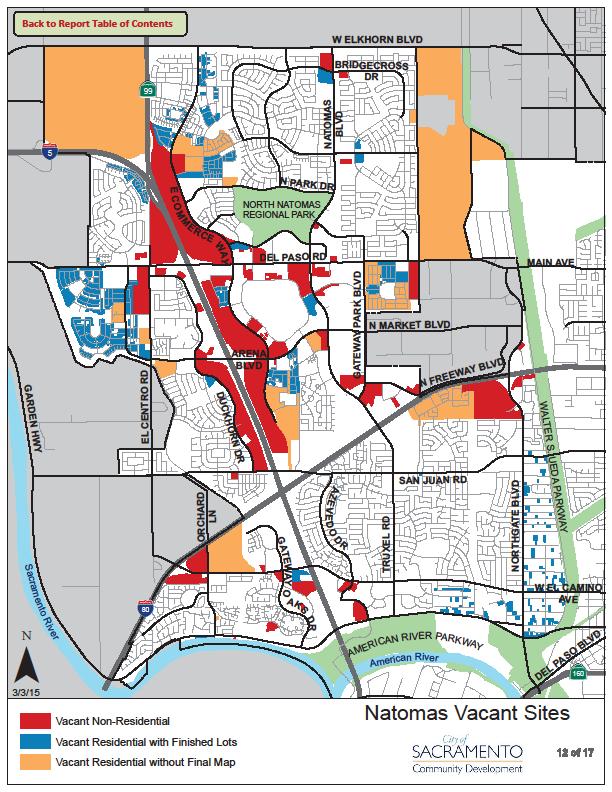
6 Where we are now: Waiting for a Letter of Final Determination (LFD) from FEMA We expect the LFD to confirm an effective map date of June 16, We may issue permits once the maps become effective We are prepared to begin accepting plans for review tomorrow The last half of the levee repairs will occur over the next 5-10 years. Once the levees are complete, the Natomas Basin will have 200- year flood protection (0.5% chance of flooding in a given year) Current development status in Natomas: 1. Substantially damaged homes (from a fire) cannot be rebuilt. 2. Unfinished neighborhoods 3. Discontinuous commercial development 4. Incomplete public facilities

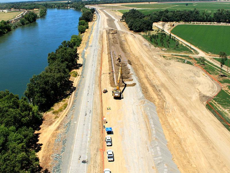

7 Levee construction progress
8


9 Natomas Field: Arena Blvd & East Commerce


10 Office complex: Del Paso & East Commerce


11 Office complex: Garden Hwy at River Plaza Dr.


12 South Natomas Community Center Park: Truxel & Pebblestone North Natomas Regional Park: Del Paso & Via Ingoglia
13 Recommendation: Criteria considered: 1. Level of overall flood risk (currently greater than 1% in any given year) 2. Desire to complete neighborhoods and provide public services 3. The levee project s dependence on annual congressional appropriations 4. FEMA requires no development restrictions in an A99 zone 5. Flood insurance is required until the levee work is complete 6. The City will require that a risk notification/hold-harmless agreement be signed for each structure built 7. The City s Comprehensive Flood Management Plan requires that development within rescue areas meet evacuation location standards 8. Good coordination with FEMA An advanced warning evacuation system A public outreach campaign Two Community Development staff obtained Certified Floodplain Manager (CFM) designations
14 Recommendation: 1. Restrict residential development as follows: No more than 1,000 single-family units issued per calendar year (no more than 2,000 total by the end of the 2 nd year) No more than 500 multi-family units issued per calendar year (no more than 1,000 total by the end of the 2 nd year) 2. No restrictions on commercial development 3. Provide priority processing to substantially damaged homes (fires), public facilities, and community enhancing projects. 4. Staff will present an annual report to council which details the levee improvement progress and development activity
15 Recommendation: How we arrived at the numbers: 1. Historical data shows that about 2,800 single-family home permits were issued in 2003, the peak of activity in Natomas (nearly a third of the regional total). 3,000 housing permits were issued in the region in Residential development presents a higher risk than commercial development 3. The North Natomas Community Plan provides for 2/3 singlefamily, 1/3 multi-family development 4. Market demand appears consistent with our measured approach
16 Resources: General Information: Building Permits and Inspection Information: Planning Information: Flood Information: You may also send questions regarding planning and building to: or call 311
17 Questions?
Presented by: Connie Perkins, PE, CFM April 20, 2016
 Presented by: Connie Perkins, PE, CFM April 20, 2016 City of Sacramento s Flood History Need for a Comprehensive Flood Management Plan (CFMP) Overview of Sacramento s CFMP 2016 Next Steps Sacramento
SUBJECT: LAND USE PLANNING POLICY WITHIN THE 100 YEAR FLOODPLAIN (REPORT #2)
") DEPARTMENT OF PLANNING AND DEVELOPMENT City Council Sacramento, California Honorable Members in Session: CITY OF SACRAMENTO CALIFORNIA August 20, 1993 1231 1 STREET ROOM 200 SACRAMENTO, CA 95814-2998 ENVIRONMENTAL
DEPARTMENT OF PLANNING AND DEVELOPMENT City Council Sacramento, California Honorable Members in Session: CITY OF SACRAMENTO CALIFORNIA August 20, 1993 1231 1 STREET ROOM 200 SACRAMENTO, CA 95814-2998 ENVIRONMENTAL
U.S. Army Corp of Engineers
 U.S. Army Corp of Engineers PL 84-99 Levee Inspections and Levee Certification Hank DeHaan Rock Island District March 9, 2011 US Army Corps of Engineers U.S. Army Corps of Engineers Flood Damage Reduction
University Drive Flood Risk Management Project Phase I 58 th Ave S to 500 S of 64 th Ave S City of Fargo Project FM-15-C1
 University Drive Flood Risk Management Project Phase I 58 th Ave S to 500 S of 64 th Ave S City of Fargo Project FM-15-C1 Public Informational Meeting October 15, 2015 6:00 P.M. Overview Flood Risk FEMA
National Flood Risk Management Program
 National Flood Risk Management Program US Army Corps of Engineers Floodplain Managers Association Sacramento, California July 29, 2010 Judy Soutiere Institute for Water Resources A Shared Responsibility
King County Flood Control District Flood Risk Reduction Work Program and Accomplishments
 King County Flood Control District Flood Risk Reduction Work Program and Accomplishments Brian Murray Water and Land Resources Division April 26, 2016 Department of Natural Resources and Parks Water and
Flood Risk Management and Nonstructural Flood Risk Adaptive Measures
 Flood Risk Management and Nonstructural Flood Risk Adaptive Measures Randall Behm, P.E., CFM USACE-Omaha District Chair, National Nonstructural Flood Proofing Committee US Army Corps of Engineers BUILDING
Planning Process---Requirement 201.6(b): An open public involvement process is essential to the development of an effective plan.
: An open public involvement process is essential to the development of an effective plan.") Section 3 Capability Identification Requirements Planning Process---Requirement 201.6(b): An open public involvement process is essential to the development of an effective plan. Documentation of the Planning
Section 3 Capability Identification Requirements Planning Process---Requirement 201.6(b): An open public involvement process is essential to the development of an effective plan. Documentation of the Planning
Floodplain Management Plan
 Floodplain Management Plan CITY OF FORT WORTH TFMA 2016 Spring Conference March 10, 2016 Agenda 1. Fort Worth Higher Standards (NFIP & CRS) 2. Floodplain Management Plan Overview and Results 3. Project
Flooding Part One: BE Informed. Department of Planning & Development
 Flooding Part One: BE Informed Department of Planning & Development Introduction The residents of the City of Noblesville enjoy many benefits from being located on the banks of the White River. These benefits
Memorandum. November 11,2010. Trinity River Corridor Project Committee Members: David
 Memorandum DATE November 11,2010 CITY OF DALLAS TO Trinity River Corridor Project Committee Members: David A. Neumann (Chairman) Vonciel Jones Steve Salazar (Vice-Chair) Delia Mayor Pro Tern Dwaine Caraway
Community Rating System. National Flood Insurance Program
 National Flood Insurance Program Community Rating System A Local Official s Guide to Saving Lives Preventing Property Damage Reducing the Cost of Flood Insurance FEMA B-573 / May 2015 How the Community
DES MOINES CITY OF TWO RIVERS. Flooding Risk & Impact to Development
 DES MOINES CITY OF TWO RIVERS Flooding Risk & Impact to Development River System Des Moines Flood Protection Des Moines Flood Protection cont. Infrastructure Over 24 miles of levees 21stormwater pump stations
Improving Coordinated Flood Preparedness and Response
 Improving Coordinated Flood Preparedness and Response Illinois Silver Jackets Hank DeHaan Rock Island and Saint Louis Districts October 2011 US Army Corps of Engineers Illinois Silver Jackets Program Illinois
SUBJECT: EXECUTIVE DIRECTOR'S REPORT FOR JANUARY 19, 2017 WATER INFRASTRUCTURE IMPROVEMENTS FOR THE NATION (WIIN) ACT
 ACT") ITEM 2 Agenda of January 19, 2017 TO: FROM: Board of Directors Sacramento Area Flood Control Agency Richard M. Johnson, Executive Director (916) 874-7606 SUBJECT: EXECUTIVE DIRECTOR'S REPORT FOR JANUARY
ITEM 2 Agenda of January 19, 2017 TO: FROM: Board of Directors Sacramento Area Flood Control Agency Richard M. Johnson, Executive Director (916) 874-7606 SUBJECT: EXECUTIVE DIRECTOR'S REPORT FOR JANUARY
RECOMMENDATION: Staff recommends the Board adopt Resolution No approving SAFCA s Fiscal Year Final Budget.
 ITEM 5 Agenda of August 18, 2016 TO: FROM: SUBJECT: Sacramento Area Flood Control Agency Board of Directors Jason D. Campbell, Deputy Executive Director (916) 874-7606 APPROVING FINAL FISCAL YEAR 2016-17
Federal Emergency Management Agency
 Page 1 of 3 COMMUNITY AND MAP PANEL INFORMATION COMMUNITY CITY OF MARGATE CITY, ATLANTIC COUNTY, NEW JERSEY LEGAL PROPERTY DESCRIPTION A parcel of land, as described in Deed recorded in Book 4826, page
Skagit County Flood Insurance Study Update. Ryan Ike, CFM FEMA Region 10
 Skagit County Flood Insurance Study Update Ryan Ike, CFM FEMA Region 10 Skagit County Flood Insurance Study Process Overview Process, Schedule, & Deliverables Base Flood Elevations, Modeling, & Levees
COUNTY OF SACRAMENTO CALIFORNIA
 COUNTY OF SACRAMENTO CALIFORNIA Control No.: 2002-0105 Type: GPB A D D E N D U M # 4 For the Agenda of: July 20, 2010 Agenda Item No. 4 TO: FROM: BOARD OF SUPERVISORS PLANNING AND COMMUNITY DEVELOPMENT
Taylor County, Florida Community Coordination and Outreach (CCO) Meeting
 Meeting") Taylor County, Florida Community Coordination and Outreach (CCO) Meeting Suwannee River Water Management District April 26, 2017 11:00AM to 12:00PM Taylor County Administration Building, 201 E. Green Street,
Taylor County, Florida Community Coordination and Outreach (CCO) Meeting Suwannee River Water Management District April 26, 2017 11:00AM to 12:00PM Taylor County Administration Building, 201 E. Green Street,
Historic Structures in the Floodplain
 Historic Structures in the Floodplain Frances McJunkin, CFM Deputy Director Sal Vitko Hazard Reduction Planner County of Lycoming Department of Planning & Community Development Pennsylvania Statewide Conference
Upper Joachim Creek Public Survey on Potential Flood Risk Reduction
 Upper Joachim Creek Public Survey on Potential Flood Risk Reduction This survey is intended to help the interagency planning committee to receive public feedback on specific flood risk reduction techniques,
Passaic River Basin Flood Advisory Commission Report/Status of Recommendations. October 2014 Update
 Passaic River Basin Flood Advisory Commission Report/Status of Recommendations October 2014 Update Passaic River Basin Flood Advisory Commission April 2010: By Executive Order, Governor Christie created
A Flood Mitigation Plan for the Non-Tidal N.J. Section of the Delaware River Basin. Sussex County Kick-off Meeting November 28, 2006
 A Flood Mitigation Plan for the Non-Tidal N.J. Section of the Delaware River Basin Sussex County Kick-off Meeting November 28, 2006 The Delaware River. crosses many boundaries Four states: DE, PA, NJ,
Flood Plain Management Services (FPMS) Program
 Program") Flood Plain Management Services (FPMS) Program 2016 Winter Stakeholder Partnering Forum March 2016 Mario Beddingfield, P.E., CFM Hydraulic Engineer/FPMS Program Manager H&H/Water Control Branch U.S. Army
Flood Plain Management Services (FPMS) Program 2016 Winter Stakeholder Partnering Forum March 2016 Mario Beddingfield, P.E., CFM Hydraulic Engineer/FPMS Program Manager H&H/Water Control Branch U.S. Army
City of Sea Isle City Department of Construction and Zoning Physical Location: 4501 Park Road (rear entrance)
") City of Sea Isle City Department of Construction and Zoning Physical Location: 4501 Park Road (rear entrance) Mailing Address: 4416 Landis Avenue Sea Isle City, New Jersey 08243 609-263-1166 FAX: 609-263-1366
City of Sea Isle City Department of Construction and Zoning Physical Location: 4501 Park Road (rear entrance) Mailing Address: 4416 Landis Avenue Sea Isle City, New Jersey 08243 609-263-1166 FAX: 609-263-1366
FEMA FLOOD MAPS Public Works Department Stormwater Management Division March 6, 2018
 FEMA FLOOD MAPS Public Works Department Stormwater Management Division March 6, 2018 Presentation Overview FEMA National Flood Insurance Program (NFIP) FEMA Community Rating System (CRS) Flood Insurance
10526 Bermuda Isle Dr. Tampa, FL 33647
 Flood Analysis Memo Property Address In Partnership with: ** This property is NOT within a high-risk flood zone ** This property is located in a FEMA low-risk zone designated as Zone X - an area of minimal
Frequently Asked Questions Oxbow / Hickson / Bakke Ring Levee Option
 Frequently Asked Questions Oxbow / Hickson / Bakke Ring Levee Option October 16, 2012 Q1. Why has the position on a ring-levee changed? The feasibility study recommended buy-outs for areas with staging
ADVISORY BASE FLOOD ELEVATIONS (ABFEs)
") The Department of Homeland Security s Federal Emergency Management Agency is committed to helping communities that were impacted by Hurricanes Katrina and Rita rebuild safer and stronger. Following catastrophic
The Department of Homeland Security s Federal Emergency Management Agency is committed to helping communities that were impacted by Hurricanes Katrina and Rita rebuild safer and stronger. Following catastrophic
[Letter to be printed on official Levee Sponsor letterhead]
![[Letter to be printed on official Levee Sponsor letterhead]](/thumbs/84/89135049.jpg "[Letter to be printed on official Levee Sponsor letterhead]") [Letter to be printed on official Levee Sponsor letterhead] [Date] COL Joel R. Cross, Commander US Army Corps of Engineers, Omaha District 1616 Capitol Avenue Omaha, Nebraska 68102-4901 RE: [Levee Sponsor
[Letter to be printed on official Levee Sponsor letterhead] [Date] COL Joel R. Cross, Commander US Army Corps of Engineers, Omaha District 1616 Capitol Avenue Omaha, Nebraska 68102-4901 RE: [Levee Sponsor
Living with levees: using tolerable risk guidelines in California
 Living with levees: using tolerable risk guidelines in California Jessica Ludy, CFM. Arcadis-U.S. Inc. Larry Roth, G.E., P.E., Arcadis-US, Inc. Dustin Jones, P.E., Delta Stewardship Council 1 Hoogwater
RESOLUTION - APPROVING FINAL FISCAL YEAR BUDGET
 ITEM 12 TO: FROM: SUBJECT: Sacramento Area Flood Control Agency Board of Directors Richard M. Johnson, Executive Director (916) 874-7606 RESOLUTION - APPROVING FINAL FISCAL YEAR 2015-16 BUDGET OVERVIEW:
Georgia Flood M.A.P. Program Risk MAP Plenary Session GAFM 2011
 Georgia Flood M.A.P. Program Risk MAP Plenary Session GAFM 2011 Collis Brown, Georgia DNR March 24, 2011 GA Flood Map Modernization Responsible for end-to-end production Developed aggressive outreach program
Silver Jackets - Flood Risk Management Program
 COOPERATING TECHNICAL PARTNER INFORMATION EXCHANGE Silver Jackets - Flood Risk Management Program August 31, 2017 Association of State Floodplain Managers AUDIO AND WEB SETTINGS Your Participation Open
Floodplain Management 101. Mississippi Emergency Management Agency Floodplain Management Bureau
 Floodplain Management 101 Mississippi Emergency Management Agency Floodplain Management Bureau Stafford Act The Stafford Disaster Relief and Emergency Assistance Act (Stafford Act) (Public Law 100-707)
The National Flood Insurance Program and Flood Insurance Rate Map for San Francisco. Presentation at Treasure Island Community Meeting
 The National Flood Insurance Program and Flood Insurance Rate Map for San Francisco Presentation at Treasure Island Community Meeting October 17, 2007 1 National Flood Insurance Program (NFIP) Overview
East Hartford. Challenges
 East Hartford The Town of East Hartford is a suburban community of approximately 52,212 located east of the City of Hartford and west of the Town of Manchester. The Town covers slightly more than 18 square
Biggert-Waters Flood Insurance Reform and Modernization Act of 2012
 Biggert-Waters Flood Insurance Reform and Modernization Act of 2012 On July 6, 2012, President Obama signed into law the Biggert-Waters Flood Insurance Reform Act of 2012, which reauthorizes and reforms
10526 Bermuda Isle Dr. Tampa, FL 33647
 Flood Analysis Memo Property Address 10526 Bermuda Isle Dr. In Partnership with: ** This property is NOT within a high-risk flood zone ** 10526 Bermuda Isle Dr. BFE = 35 ft This property is located in
In 1993, spring came in like a lion, but refused
 36 UNIVERSITIES COUNCIL ON WATER RESOURCES ISSUE 130, PAGES 36-40, MARCH 2005 FEMA and Mitigation: Ten Years After the 1993 Midwest Flood Norbert Director of Federal Insurance and Mitigation Division Federal
CITY OF PLANTATION ENGINEERING DEPARTMENT INTEROFFICE MEMORANDUM NO
 CITY OF PLANTATION ENGINEERING DEPARTMENT INTEROFFICE MEMORANDUM NO. 2013-003 DATE: October 22, 2012 TO: Mayor and Members of City Council FROM: Brett W. Butler, PE, CFM City Engineer SUBJECT: CRS Program
Memorandum. Jt~1A. Jordan, P.E. Assistant City Manager CITY OF DALLAS
 Memorandum DATE May 15, 2009 CITY OF DALLAS TO Trinity River Committee Members: David A. Neumann (Chair) Mayor Pro Tem Dr. Elba Garcia (Vice-Chair) Deputy Mayor Pro Tem Dwaine Caraway Carolyn R. Davis
Requirements for Mapping Levees Complying with Section of the NFIP Regulations
 FACT SHEET Requirements for Mapping Levees Complying with Section 65.10 of the NFIP Regulations As part of a mapping project, it is the levee owner s or community s responsibility to provide data and documentation
Piloting LAMP from Stream to Sea
 Piloting LAMP from Stream to Sea FEMA s New Analysis and Mapping Procedures for Non-Accredited Levee Systems Presented by: Eric Simmons, CFM Senior Engineer, FEMA Region IX Presentation Outline Levee Issues
Joint Recommendations on Levee Policy. Association of State Floodplain Managers. National Association of Flood and Stormwater Management Agencies
 Joint Recommendations on Levee Policy developed by the Association of State Floodplain Managers and the National Association of Flood and Stormwater Management Agencies from discussions at the Flood Risk
Public Information Meeting Rahway River Basin, New Jersey Flood Risk Management Feasibility Study
 Public Information Meeting Rahway River Basin, New Jersey Flood Risk Management Feasibility Study U.S. Army Corps of Engineers, New York District New Jersey Department of Environmental Protection 11 &
Coastal Flood Maps. Chris Penney. Program Manager USACE Baltimore District 2 June US Army Corps of Engineers BUILDING STRONG
 Coastal Flood Maps Chris Penney Program Manager USACE Baltimore District 2 June 2015 US Army Corps of Engineers There are two types of coastal flood risk maps They look different They communicate different
Action Items for Flood Risk Management on Wildcat Creek Interagency success with floodplain management plans and flood forecast inundation maps
 Presentation to USACE 2012 Flood Risk Management and Silver Jackets Joint Workshop, Harrisburg, Pennsylvania Action Items for Flood Risk Management on Wildcat Creek Interagency success with floodplain
IF REAL ESTATE IS YOUR PROFESSION, THEN POLITICS IS YOUR BUSINESS
 IF REAL ESTATE IS YOUR PROFESSION, THEN POLITICS IS YOUR BUSINESS Ryan Castle Government Affairs Director Ryan@CharlestonRealtors.com 843.793.5212 LOCAL COMMERCIAL ISSUES In the last year, here are some
Flood Analysis Memo. 629 Orangewood Dr. Dunedin, FL BFE = 21 ft
 Flood Analysis Memo Property Address 629 Orangewood Dr. In Partnership with: ** This property is NOT within a high-risk flood zone ** 629 Orangewood Dr. BFE = 21 ft This property is located in the FEMA
Floodplain Management and Florida s Initiatives for Resiliency
 Floodplain Management and Florida s Initiatives for Resiliency Steve Martin, CFM, State NFIP Coordinator THE WAY FORWARD IN FLORIDA NFIP key elements: Insurance, Mapping, Regulations & Mitigation CRS improves
Attachment B. King County Flood Control Zone District Work Program
 Attachment B King County Flood Control Zone District Work Program The King County Flood Control Zone District work program is comprised of two major categories: Programmatic Work Program o Flood Preparedness,
National Flood Insurance Program s Community Rating System:
 National Flood Insurance Program s Community Rating System: An Introduction and Discussion of the RDO Role: 1/2 Presentation - 1/2 Discussion Bill Lesser, Federal Insurance and Mitigation Administration,
Using GISWeb to Determine Your Property s Flood Zone
 Using GISWeb to Determine Your Property s Flood Zone 1. In a new browser window, go to http://www.co.santacruz.ca.us/departments/geographicinformationsystemsgis.aspx 2. Click on GISWeb - GIS Mapping Application
A Little Less Conversation a Little More ACTION! Louie Greenwell, GISP, CFM T&M Associates Carey Johnson KY Division of Water
 A Little Less Conversation a Little More ACTION! Louie Greenwell, GISP, CFM T&M Associates Carey Johnson KY Division of Water Topics Covered It s all about ACTION! Kentucky s plan for delivering actions
210 W Canal Dr Palm Harbor, FL 34684
 Flood Analysis Memo Property Address In Partnership with: ** This property is within a high risk flood zone ** BFE = 6 ft This property is located in the FEMA designated high-risk zone, Zone AE - an area
Flood Insurance vs. Disaster Assistance. Janice Mitchell FEMA, Region
 Flood Insurance vs. Disaster Assistance Janice Mitchell FEMA, Region 4 770-220-5441 National Flood Insurance Program (NFIP) Nearly 20,000 communities participating 195,350,633 policies in force $37,417,000,898,700
Simsbury. Challenges Capitol Region Natural Hazards Mitigation Plan Update - Page 356
 Simsbury Simsbury is a suburban community of about 23,600 located in the western portion of the Capitol Region. Its land area encompasses 33.9 square miles. Elevation in town generally ranges from about
Northwest Flood Fight Workshops
 Northwest Flood Fight Workshops September 24, 2014 IWR Webinar D. Leslie Miller, P.E. (Les) Flood Preparedness Program Manager US Army Corps of Engineers, Portland District US Army Corps of Engineers Welcome
History of Floodplain Management in Ascension Parish
 History of Floodplain Management in Ascension Parish presented by: Kara Moree Floodplain Coordinator February 6, 2012 Floodplain 101 Floodplain 101 Base or 1% Flood: A flood having a 1% chance of being
SILVER JACKETS: TEAMING TO MITIGATE AND MANAGE STATE FLOOD HAZARD PRIORITIES
 SILVER JACKETS: TEAMING TO MITIGATE AND MANAGE STATE FLOOD 255 255 255 237 237 237 0 0 0 217 217 217 163 163 163 200 200 200 131 132 122 239 65 53 80 119 27 HAZARD PRIORITIES 110 135 120 252 174.59 112
What Was Updated in 2004 in Hennepin Countywide Maps?
 What Was Updated in 2004 in Hennepin Countywide Maps? Combined the city and township maps into one countywide index Done by USACE Mainly digital capture of old floodplain boundaries; some spots with shifts
City of Santa Clarita Engineering Services Division Valencia Boulevard Santa Clarita, CA (661) Levee Certification
 Levee Certification") City of Santa Clarita Engineering Services Division 23920 Valencia Boulevard Santa Clarita, CA 91355 (661) 255-4942 Levee Certification FEMA is currently updating the nation s flood hazard maps under a
City of Santa Clarita Engineering Services Division 23920 Valencia Boulevard Santa Clarita, CA 91355 (661) 255-4942 Levee Certification FEMA is currently updating the nation s flood hazard maps under a
ASFPM RECOMMENDED TASK FORCE ACTIONS
 Association of State Floodplain Managers, Inc. 2809 Fish Hatchery Road, Suite 204, Madison, WI 53713 Phone: 608-274-0123 Fax: 608-274-0696 Website: www.floods.org Email: asfpm@floods.org Federal Interagency
SUBJECT: EXECUTIVE DIRECTOR'S REPORT FOR AUGUST 20, 2015
 ITEM 1 TO: FROM: Board of Directors Sacramento Area Flood Control Agency Richard M. Johnson, Executive Director (916) 874-7606 SUBJECT: EXECUTIVE DIRECTOR'S REPORT FOR AUGUST 20, 2015 SAFCA Intent to Serve
Floodplain Remapping
 Floodplain Remapping Floodplain Remapping Why remap the regulatory floodplain? More accurate maps means more effective floodplain management and safer communities. Who is remapping the regulatory floodplain?
FREQUENTLY ASKED QUESTION ABOUT FLOODPLAINS Michigan Department of Environmental Quality
 FREQUENTLY ASKED QUESTION ABOUT FLOODPLAINS Michigan Department of Environmental Quality WHAT IS A FLOOD? The National Flood Insurance Program defines a flood as a general and temporary condition of partial
Executive Summary Levee Engineering Assessments September 26, 2014
 Executive Summary s September 26, 2014 Purpose Multnomah County Drainage District (MCDD), the agency responsible for managing the Columbia Corridor levee system, received notification that in August of
DAEN SUBJECT: Little Colorado River at Winslow, Arizona, Flood Risk Management Project
 per year. In addition to the above, the Navajo County Flood Control District would be fully responsible for performing the investigation, cleanup, and response of hazardous materials on the project sites.
Chapter 7 Appendix B: National Flood Insurance Program Summary for Kaua'i County, 2015 Update
 Chapter 7 Appendix B: National Flood Insurance Program Summary for Kaua'i County, 2015 Update Topic Considerations Description INSURANCE SUMMARY STAFF RESOURCES How many NFIP policies are in Kaua i County?
How to Get Property Owners to Floodproof
 How to Get Property Owners to Floodproof French Wetmore, French & Associates Pat Skinner, Louisiana State University How to Get Property Owners to Floodproof Objective: get people to protect themselves
Floodplain Management. City Council Work Session April 16, 2013
 Floodplain Management City Council Work Session April 16, 2013 1 Discussion Agenda Flood Insurance Rate Changes Community Rating System Recommendation Floodplain Ordinance Enhancements Modifications Public
Durham County Preliminary Flood Hazard Data Public Meeting. July 28, 2016
 Durham County Preliminary Flood Hazard Data Public Meeting July 28, 2016 Why Are We Here New flood hazard data has been released as Preliminary for Durham County Statutory Due Process for review/comments
Preliminary DFIRM Community Coordination (PDCC) Meeting Gilchrist & Levy Counties, FL. April 30, 2015
 Meeting Gilchrist & Levy Counties, FL. April 30, 2015") Preliminary DFIRM Community Coordination (PDCC) Meeting Gilchrist & Levy Counties, FL April 30, 2015 Agenda 1. Introductions 2. Study Process and Timeline 3. Overview of Preliminary Products 4. Overview
Preliminary DFIRM Community Coordination (PDCC) Meeting Gilchrist & Levy Counties, FL April 30, 2015 Agenda 1. Introductions 2. Study Process and Timeline 3. Overview of Preliminary Products 4. Overview
Federal Flood Risk Management Standards. An Update on Federal Flood Resilience Standards
 Federal Flood Risk Management Standards An Update on Federal Flood Resilience Standards Purpose of Today s Briefing Facilitate the understanding of Executive Order (E.O.)13690 and its implementation Discuss
Section 19: Basin-Wide Mitigation Action Plans
 Section 19: Basin-Wide Mitigation Action Plans Contents Introduction...19-1 Texas Colorado River Floodplain Coalition Mitigation Actions...19-2 Mitigation Actions...19-9 Introduction This Mitigation Plan,
Many of the changes to the NFIP were recently revised on March 21, 2014 by the Homeowner Flood Insurance Affordability Act of 2014.
 F l oodawa r e ne swe e k Ma r c h19-ma r c h25 2017 Below is a summary of the topics we will discuss today. On July 6, 2012, the Biggert-Waters Flood Insurance Reform Act of 2012 was passed by Congress
CRS State Profile: Wyoming
 CRS State Profile: Wyoming This is a profile for communities in your state that are participating in the Community Rating System (CRS). This profile is intended to provide information to the State NFIP
Disaster Insurance: Are States and Insurance Companies Prepared?
 Disaster Insurance: Are States and Insurance Companies Prepared? National Conference of State Legislatures 2015 Legislative Summit Roy Wright Deputy Associate Administrator for Insurance and Mitigation
Reconstruction Implications
 Federal Emergency Management Agency (FEMA) Recovery Guidance Advisory Base Flood Elevation (ABFE) of April 12, 2006 Reconstruction Implications Presentation to: City of New Orleans July 6 th, 2006 Lambert
TESTIMONY. Association of State Floodplain Managers, Inc.
 ASSOCIATION OF STATE FLOODPLAIN MANAGERS, INC. 2809 Fish Hatchery Road, Suite 204, Madison, Wisconsin 53713 www.floods.org Phone: 608-274-0123 Fax: 608-274-0696 Email: asfpm@floods.org TESTIMONY Association
Georgia Flood M.A.P. Program
 Georgia Flood M.A.P. Program Georgia Flood M.A.P. Program The Upper Chattahoochee River Basin Risk MAP Project Transitioning State Program to align with FEMA s Risk MAP Program Increase focus on risk assessment
King County Flood Control District 2015 Work Program
 Attachment A 2015 Work Plan 10-24-14 King County Flood Control District 2015 Work Program The District work program is comprised of three categories: district oversight and policy development, operations,
Agenda. Introduction. Introduction -Map Study Lifecycle. Insurance Benefits of New Map
 Agenda Introduction Effects of Map Changes on Flood Insurance Lower risk to higher risk ( Grandfathering ) Higher risk to lower risk ( Conversion ) No Change Vertical Datum change Summary Levees Levees
Contract Review City Council
 CITY COUNCIL Kevin Johnson, Mayor Angelique Ashby, District 1 Allen Warren, District 2 Jeff Harris, District 3 Steve Hansen, District 4 Jay Schenirer, District 5 Eric Guerra, District 6 Rick Jennings,
Mitigation Works. 0 With its devastating combination of water, mud, and sewage, the damages caused by flooding are particularly wrenching.
 0 Nationwide, structures built to NFIP standards are estimated to suffer 80% less damage than other structures, and save more than $ 1 Billion in flood damages annually. 0 With its devastating combination
ECONOMIC EVALUATION OF FLOODPLAIN MANAGEMENT AND FLOOD MITIGATION
 ECONOMIC EVALUATION OF FLOODPLAIN MANAGEMENT AND FLOOD MITIGATION CITY OF BIRMINGHAM, ALABAMA EDWIN REVELL, CFM FLOOD PLAIN ADMINISTRATOR DENISE PRUITT, CFM PROJECT PLANNER PRESENTATION OUTLINE 1. BACKGROUND/LOCATION
Flood Insurance and Levees
 Flood Insurance and Levees NFIP Requirements are found in 44 (CFR) Section 65.10 General Requirements 65.10(a) Design Criteria 65.10(b) Operation Plans and Criteria 65.10(c) Maintenance Plans and Criteria
EMERGENCY ACTION PLAN GUIDEBOOK
 EMERGENCY ACTION PLAN GUIDEBOOK Presented by: Terry Zien and Bonnie Greenleaf US Army Corps of Engineers Background Purpose Overview of Guidebook Discussion of Key Chapters Minnesota Silver Jackets Natural
May 5, Write Your Own (WYO) Principal Coordinators and the National Flood Insurance Program (NFIP) Servicing Agent
 Principal Coordinators and the National Flood Insurance Program (NFIP) Servicing Agent") U.S. Department of Homeland Security 500 C Street, SW Washington, DC 20472 W-13026 May 5, 2013 MEMORANDUM FOR: Write Your Own (WYO) Principal Coordinators and the National Flood Insurance Program (NFIP)
U.S. Department of Homeland Security 500 C Street, SW Washington, DC 20472 W-13026 May 5, 2013 MEMORANDUM FOR: Write Your Own (WYO) Principal Coordinators and the National Flood Insurance Program (NFIP)
Repetitive Loss Area Revisit # 6 Walter Road Area Jefferson Parish
 Repetitive Loss Area Revisit # 6 Walter Road Area Jefferson Parish www.floodhelp.uno.edu Supported by FEMA Acknowledgement The compilation if this report was managed by Erin Patton, CFM, a UNO-CHART Research
Natural Hazards Mitigation Plan Kankakee County, Illinois Executive Summary
 1. Introduction Natural Hazards Mitigation Plan Kankakee County, Illinois Executive Summary Kankakee County is subject to natural hazards that threaten life, safety, health, and welfare and cause extensive
SECTION 9: MAPS AND DATA
 SECTION 9: MAPS AND DATA Contents 9.1. NFIP Maps and Data... 9-2 9.1.1. Adopting and enforcing NFIP floodplain maps and data... 9-2 9.1.2. Adopting and enforcing more restrictive data... 9-2 9.1.3. Annexations...
Michael Taylor, PE, CFM Project Manager, AECOM August 25, 2015
 Promoting FEMA s Flood Risk Products in the Lower Levisa Watershed Michael Taylor, PE, CFM Project Manager, AECOM August 25, 2015 Agenda Study Background Flood Risk Product Overview AOMI and Mitigation
2012 Conference Report on National Flood Insurance Reform Legislation (Passed by House & Senate)
") 2012 Conference Report on National Flood Insurance Reform Legislation (Passed by House & Senate) Provision Biggert-Waters Flood Insurance Reform Act of 2012 (112th Congress) Title Biggert-Waters Flood
2012 Conference Report on National Flood Insurance Reform Legislation (Passed by House & Senate) Provision Biggert-Waters Flood Insurance Reform Act of 2012 (112th Congress) Title Biggert-Waters Flood
Testimony of the National Association of Flood And Stormwater Management Agencies. Water Resources Development Act of 2012
 National Association of Flood & Stormwater Management Agencies 1333 H Street, NW, 10th Floor West Tower, Washington, DC 20005 Phone: 202-289-8625 www.nafsma.org Testimony of the National Association of
Levees: PL84-99 and the NFIP
 Levees: PL84-99 and the NFIP Tony D. Krause, P.E., CFM Flood Risk and Floodplain Management Omaha District US Army Corps of Engineers Objectives and Overview Objectives: Identify overlaps between Federal
ASFPM Partnerships for Statewide Mitigation Actions. Alicia Williams GIS and HMP Section Manager, Amec Foster Wheeler June 2016
 ASFPM Partnerships for Statewide Mitigation Actions Alicia Williams GIS and HMP Section Manager, Amec Foster Wheeler June 2016 Summary The Concept Leveraging Existing Data and Partnerships to reduce risk