Piloting LAMP from Stream to Sea
|
|
|
- Caitlin Shepherd
- 5 years ago
- Views:
Transcription


1 Piloting LAMP from Stream to Sea FEMA s New Analysis and Mapping Procedures for Non-Accredited Levee Systems Presented by: Eric Simmons, CFM Senior Engineer, FEMA Region IX

2 Presentation Outline Levee Issues Kaunakakai Study Mapping Process Remapping Results Lessons Learned Conclusion 2
3 The Levee Issue Most levee systems accredited by FEMA are not certified in accordance with 44 CFR Regulations and mapping specifications require that the protection afforded by these levees not be recognized on a new or revised FIRM. Political, economic and media concerns resulting from large flood zone changes without adequate outreach will delay map updates, hamper risk communication and stymie hazard mitigation work. 3
4 Kaunakakai Jan. 2008, PAL agreement signed Sept. 2009, New Maui County FIRM effective March 2011, FEMA initiates effort to revisit approach to analyze and map along levees that cannot be shown as providing protection from base flood July 2013, FEMA issues guidance titled: Approach to Analyzing and Mapping Procedures for Non-Accredited levees July 2013, FEMA initiates 25 Pilot Projects 4
5 Kaunakakai Replace with high res graphic of effective FIRM 5
6 Kaunakakai South Central Coast of Molokai Flood Control Project constructed in 1950 LB levee - 3,800 and extends from north of the Town of Kaunakakai to the Pacific Ocean RB levee 1,050 and extends past the Kaunakakai Homestead Approx. population 1,200 people Approx. structures 455 6
 Inspection Report (USACE) Hydraulic Model (USACE) Analysis & Mapping Plan (LLPT)")
7 Data Collection & Analysis Top of Levee (National Levee Database) O&M Plan (County of Maui) Topographic Data (FEMA and USACE) Inspection Report (USACE) Hydraulic Model (USACE) Analysis & Mapping Plan (LLPT) 7


8 Hydraulic Analysis Natural Valley Procedure HEC-RAS 4.10 Topography Mauna Loa Hwy 8
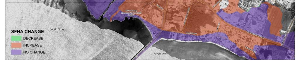
9 Re-Mapping Results Insert Riverine Only 9

10 Re-Mapping Results Insert Hurricane Only 10


11 Re-Mapping Results Insert Both Riverine and Hurricane Mapping 11
12 Re-Mapping Results Floodway & V Zone Minimal Impact Proposed SFHA Major Impact Riverine & Coastal Mapping Tie-in Using engineering judgment, not just GIS Communicating people can be flooded by multiple flooding sources 12


13 Achieving Resilient Communities Science Social Updated engineering analysis LiDAR New processes (LAMP) Outreach & partnerships Risk perception Community preparedness Personal impacts Political climate Impacts to business, homes, etc. post disaster Cost of mitigation Impacts due to new legislation Federal policy Economic 13
14 Science New topographic data (LIDAR) New Riverine Analysis New Coastal (Hurricane) Analysis New approach to analyzing and mapping along levees that cannot be shown as providing protection from the base flood 14

15 Economic 15
16 Economic Structures Impacted Effective Added Removed Proposed Riverine Coastal Totals Note: Counts do not necessarily sum because riverine and coastal floodplains overlap 16
17 Social Hard work is at the local level to Communicate risk Identify and drive mitigation opportunities Ensure and enable disaster preparedness Success can be achieved by using a communityoriented model Businesses, neighborhoods, faith-based organizations, ethnic groups, civic organizations, etc. Collaboration between and across ongoing efforts Land use planning and building codes Economic development efforts Capital improvement plans Critical infrastructure 17
18 Lessons Learned We are going to identify hazards and risk that is huge and in hundreds of areas it will take at least decades to bring flood risk into a tolerable range Many people don t care about existing flood risk, just what is depicted on a regulatory map as a result the opposition to new flood mapping will be large 18
19 Outreach Lessons Learned Public safety must be primary Coordination with elected officials is key Start outreach early it takes time Partner early and often; involving others is important and needed for success Put draft data online More outreach will be needed when revised flood zones go effective, not when issued in draft or preliminary format 19
20 Engineering Lessons Learned Less important than non-technical LAMP and PAL processes are helpful, albeit complicated, tools definitely not a cure-all Don t let the documentation and technical issues distract from the mapping Focus on identifying the floodplain Its About the Floodplain! 20
21 Other Lessons Learned Mapping raises the entire realm of levee issues A levee needs to be considered as part of a levee system for mapping Nothing Risk MAP does will reduce flood losses more than correctly identifying flood hazards behind deficient levees The effort necessary to correctly map flood hazards around levees is not too hard LAMP gives us all a uniform process and analysis procedures 21
22 Risk Communication We all will continue to struggle to effectively communicate hazards and flood risk But technology helps; 3-D viewers allow us to better understand flood hazards and flood risk; And therefore make appropriate floodplain management decisions in the future 22
23 Conclusion Levee deaccreditation is a challenging but necessary step if the we are to start reducing flood losses Public safety (not $$ and flood insurance implications) must drive decisions As we continue to build in floodplains we need to ensure accurate hazard and risk data is available to understand the consequences of this new development 23
Disaster Insurance: Are States and Insurance Companies Prepared?
 Disaster Insurance: Are States and Insurance Companies Prepared? National Conference of State Legislatures 2015 Legislative Summit Roy Wright Deputy Associate Administrator for Insurance and Mitigation
USACE Levee Safety Meeting FEMA Overview
 USACE Levee Safety Meeting FEMA Overview Christine Gaynes, CFM FEMA Region V Roger Denick, PE, CFM FEMA Region V Service Center Agenda FEMA Region V Overview FEMA Levee Program Levee Guidance Transformation
Cameron County, TX. Consultation Coordination Officer (CCO) Meeting. Please sign in (sheet at front of the room) Meeting will begin at 9:00
 Meeting. Please sign in (sheet at front of the room) Meeting will begin at 9:00") Cameron County, TX Consultation Coordination Officer (CCO) Meeting Please sign in (sheet at front of the room) Meeting will begin at 9:00 July 29, 2015 Lisa Jennings FEMA Region 6 Roles & Responsibilities
Cameron County, TX Consultation Coordination Officer (CCO) Meeting Please sign in (sheet at front of the room) Meeting will begin at 9:00 July 29, 2015 Lisa Jennings FEMA Region 6 Roles & Responsibilities
Natchitoches Parish, Louisiana Flood Insurance Study Update Risk Analysis March 3, Shona Gibson Project Monitor, FEMA Region VI
 Natchitoches Parish, Louisiana Flood Insurance Study Update Risk Analysis Shona Gibson Project Monitor, FEMA Region VI Presentation Overview Introductions Why are we here? Levee Status and Opportunities
Use of FEMA Non regulatory Flood Risk Products in Planning
 Use of FEMA Non regulatory Flood Risk Products in Planning Georgia Association of Floodplain Managers Annual Conference March 24, 2016 What are the Non regulatory Flood Risk products? Go beyond the basic
Meeting the Nation s Levee Challenges
 ASDSO USACE/FEMA Levee Discussion Meeting the Nation s Levee Challenges November 2015 Presenters: Richard Varuso, USACE Michael Bishop, FEMA 1 This Session s Objective KNOWLEDGE - Provide you with insight
Non Regulatory Risk MAP Products Flood Depth and Probability Grids
 Non Regulatory Risk MAP Products Flood Depth and Probability Grids Virginia Floodplain Management Association 2015 Floodplain Management Workshop October 29th, 2015 Nabil Ghalayini, P.E., PMP, D.WRE, CFM
Kentucky Risk MAP It s not Map Mod II
 Kentucky Risk MAP It s not Map Mod II Risk Mapping Assessment and Planning Carey Johnson Kentucky Division of Water carey.johnson@ky.gov What is Risk MAP? Risk Mapping, Assessment, and Planning (Risk MAP)
National Coastal Outreach
 National Coastal Outreach Answering Tough Questions June 11, 2013 Why Focus on Coastal Flood Risk? 120,475,000 people or 39% of the U.S. population live in counties subject to the 1% annual chance coastal
Chapter 7 Appendix B: National Flood Insurance Program Summary for Kaua'i County, 2015 Update
 Chapter 7 Appendix B: National Flood Insurance Program Summary for Kaua'i County, 2015 Update Topic Considerations Description INSURANCE SUMMARY STAFF RESOURCES How many NFIP policies are in Kaua i County?
Calhoun County Flood Insurance Study Update
 Calhoun County Flood Insurance Study Update Larry Voice FEMA Region VI September 18, 2009 AGENDA Introduction Study Overview and Status Update Levees Post-Preliminary Process Outreach Moving Forward 2
Flood Risk Products. New Techniques for Identifying and Communicating Flood Risk
 Flood Risk Products New Techniques for Identifying and Communicating Flood Risk Mark Zito, GISP, CFM GIS Specialist Amol Daxikar, GISP, CFM Project Manager March 28, 2012 1% Flood with 3 Feet Sea Level
Orange County Flood Insurance Study Update
 Orange County Flood Insurance Study Update Larry Voice FEMA Region VI August 26, 2009 AGENDA Introduction Study Overview and Status Update Levees Post-Preliminary Process Outreach Moving Forward 2 Introduction
National Flood Risk Management Program
 National Flood Risk Management Program US Army Corps of Engineers Floodplain Managers Association Sacramento, California July 29, 2010 Judy Soutiere Institute for Water Resources A Shared Responsibility
Location: Tampa, Florida March 6, 2013
 Discovery Meeting: West Florida Coastal Study Location: Tampa, Florida March 6, 2013 Agenda Introductions Why we are here Outline Risk MAP products and datasets Discovery Overview: Project scoping and
Fighting the Flood: Current Political, Regulatory and Financial Challenges
 Fighting the Flood: Current Political, Regulatory and Financial Challenges for Levee Owners Kansas City, Missouri January 23, 2013 Emerging Policy, Programs and Tools for the Management of Levee Systems
Preliminary Work Map Release
 Coastal Mapping in New Jersey Preliminary Work Map Release Monmouth County, New Jersey June 14, 2013 Agenda Introduction and Purpose of Briefing Hurricane Sandy Advisory Base Flood Elevations Transitioning
National Flood Insurance Program. Jennifer Gilbert, CFM, ANFI New Hampshire NFIP State Coordinator
 National Flood Insurance Program Jennifer Gilbert, CFM, ANFI New Hampshire NFIP State Coordinator What is the National Flood Insurance Program? Created by Congress in 1968 Participating Communities voluntarily
*How Federal Policy. Causes Flood Disasters. Leslie A. Bond, CFM LA Bond Associates
 *How Federal Policy Causes Flood Disasters Leslie A. Bond, CFM LA Bond Associates *The high cost of flood disasters *We do not know what floods cost. *Published estimates do not include all costs of disasters.
RichSmith_slate-FEMA_320x240.wmv.
 Nebraska DNR s role in the making of FEMA s Digital Flood Insurance Rate Maps Becky Groshens (grow-hands) & Shelley Schindler Important Terms: FIRM: Flood Insurance Rate Map FIS: Flood Insurance Study
Skagit County Flood Insurance Study Update. Ryan Ike, CFM FEMA Region 10
 Skagit County Flood Insurance Study Update Ryan Ike, CFM FEMA Region 10 Skagit County Flood Insurance Study Process Overview Process, Schedule, & Deliverables Base Flood Elevations, Modeling, & Levees
Levees: PL84-99 and the NFIP
 Levees: PL84-99 and the NFIP Tony D. Krause, P.E., CFM Flood Risk and Floodplain Management Omaha District US Army Corps of Engineers Objectives and Overview Objectives: Identify overlaps between Federal
Analysis and Mapping Procedures for Non-Accredited Levees
 Analysis and Mapping Procedures for Non-Accredited Levees Proposed Approach for Public Review December 9, 2011 www.fema.gov/plan/prevent/fhm/rm_main.shtm 1 877 FEMA MAP Executive Summary Background This
FEMA s Flood Map Modernization Preparing for FY09 and Beyond: Integrated Flood Data Update, Risk Assessment, and Mitigation Planning
 FEMA s Flood Map Modernization Preparing for FY09 and Beyond: Integrated Flood Data Update, Risk Assessment, and Mitigation Planning DRAFT CONCEPT PAPER June 1, 2007 Integrated Flood Data Update, Risk
Updates to Maine Coastal Flood Insurance Rate Maps (FIRM s): What a Local Official Should Know. Presented by: Steve Johnson, P.E.
: What a Local Official Should Know. Presented by: Steve Johnson, P.E.") Updates to Maine Coastal Flood Insurance Rate Maps (FIRM s): What a Local Official Should Know Presented by: Steve Johnson, P.E. Town Engineer October 4, 2018 Introduction Federal Emergency Management
Updates to Maine Coastal Flood Insurance Rate Maps (FIRM s): What a Local Official Should Know Presented by: Steve Johnson, P.E. Town Engineer October 4, 2018 Introduction Federal Emergency Management
10/5/2015. What Makes a Sound Floodplain Management Program? What are the Flood Problems in your Community?
 The Community Rating System (CRS) and Hazard Mitigation Planning Preparing Your Community Through Common Program Goals September 3, 2015 What Makes a Sound Floodplain Management Program? Know your community
ASFPM Partnerships for Statewide Mitigation Actions. Alicia Williams GIS and HMP Section Manager, Amec Foster Wheeler June 2016
 ASFPM Partnerships for Statewide Mitigation Actions Alicia Williams GIS and HMP Section Manager, Amec Foster Wheeler June 2016 Summary The Concept Leveraging Existing Data and Partnerships to reduce risk
SECTION 9: MAPS AND DATA
 SECTION 9: MAPS AND DATA Contents 9.1. NFIP Maps and Data... 9-2 9.1.1. Adopting and enforcing NFIP floodplain maps and data... 9-2 9.1.2. Adopting and enforcing more restrictive data... 9-2 9.1.3. Annexations...
The Changing NFIP, the CRS & Local Governments. Scott Pippin, J.D., M.E.P.D.
 The Changing NFIP, the CRS & Local Governments Scott Pippin, J.D., M.E.P.D. Flood Insurance Reform Biggert Waters 2012 (BW12) Homeowner Flood Insurance Affordability Act of 2014 (HFIAA) Bigger Waters 2012
Bucks County, PA Flood Risk Review Meeting. November 2014
 Bucks County, PA Flood Risk Review Meeting November 2014 Agenda for Today Risk MAP Program overview Overview of non-regulatory Flood Risk Products and datasets Discuss mitigation action Technical overview
CITY OF PLANTATION ENGINEERING DEPARTMENT INTEROFFICE MEMORANDUM NO
 CITY OF PLANTATION ENGINEERING DEPARTMENT INTEROFFICE MEMORANDUM NO. 2013-003 DATE: October 22, 2012 TO: Mayor and Members of City Council FROM: Brett W. Butler, PE, CFM City Engineer SUBJECT: CRS Program
Flood Protection Structure Accreditation Task Force: Final Report
 Flood Protection Structure Accreditation Task Force: Final Report November 2013 Message from the Administrator and the Assistant Secretary of the Army (Civil Works) The United States Army Corps of Engineers
Short Course on Floodplain Management
 Short Course on Floodplain Management A Reconnaissance Study on the Market Impacts on Elevated Homes in Known Floodplains City of Snoqualmie Case Study By Ron Throupe, Bob Freitag, Rhonda Montgomery Market
Joint Recommendations on Levee Policy. Association of State Floodplain Managers. National Association of Flood and Stormwater Management Agencies
 Joint Recommendations on Levee Policy developed by the Association of State Floodplain Managers and the National Association of Flood and Stormwater Management Agencies from discussions at the Flood Risk
ROI for Joining CRS. Floodplain Management Association Conference. Sacramento, CA. September 2016
 ROI for Joining CRS Floodplain Management Association Conference Sacramento, CA September 2016 Agenda Joining CRS Challenges ROI Tips Wrap Up 1 FMA Conference What is CRS? Community Rating System Voluntary
FLOODPLAIN MANAGEMENT PLAN 2015 ANNUAL PROGRESS REPORT
 FLOODPLAIN MANAGEMENT PLAN 2015 ANNUAL PROGRESS REPORT Hinds County (Unincorporated) NFIP Community Number 280070 The 2015 Floodplain Management Plan Annual Progress Report on the progress made in implementing
CNMS and FOA: A Year in Review. Rick Sacbibit, P.E. Andy Read, CFM FEMA HQ, Risk Analysis Division June 4, 2015
 CNMS and FOA: A Year in Review Rick Sacbibit, P.E. Andy Read, CFM FEMA HQ, Risk Analysis Division June 4, 2015 Overview Current NVUE Status NVUE Cliff Update on CNMS Web Viewer CNMS Guidance Updates FOA
Community Rating System. National Flood Insurance Program
 National Flood Insurance Program Community Rating System A Local Official s Guide to Saving Lives Preventing Property Damage Reducing the Cost of Flood Insurance FEMA B-573 / May 2015 How the Community
Coordinating CRS Success on a County Scale. Presented at the 41st Annual ASFPM Conference Managing Flood Risk in the Heartland
 Coordinating CRS Success on a County Scale Presented at the 41st Annual ASFPM Conference Managing Flood Risk in the Heartland May 3, 2017 Today's Speaker Cynthia Bianco, CFM, AICP/PP Community Resiliency
SOUTH CENTRAL REGION MULTI-JURISDICTION HAZARD MITIGATION PLAN. Advisory Committee Meeting September 12, 2012
 SOUTH CENTRAL REGION MULTI-JURISDICTION HAZARD MITIGATION PLAN Advisory Committee Meeting September 12, 2012 AGENDA FOR TODAY Purpose of Meeting Engage All Advisory Committee Members Distribute Project
MUNICIPAL LAND USE STRATEGIES for Improving Flood Resilience
 MUNICIPAL LAND USE STRATEGIES for Improving Flood Resilience Strategy for a Flood Resistant Southern Tier Central Region (LWRP project) This presentation was prepared by Southern Tier Central Regional
4 TH ANNUAL CAPE COASTAL CONFERENCE. Adaptation Planning, Environmental Economics and Community Engagement
 4 TH ANNUAL CAPE COASTAL CONFERENCE THE RESILIENT CAPE COD PROJECT Adaptation Planning, Environmental Economics and Community Engagement K r i s t y S e n a t o r i, Cape Cod Commission NOAA COASTAL RESILIENCY
Federal Flood Risk Management Standards. An Update on Federal Flood Resilience Standards
 Federal Flood Risk Management Standards An Update on Federal Flood Resilience Standards Purpose of Today s Briefing Facilitate the understanding of Executive Order (E.O.)13690 and its implementation Discuss
Georgia Flood M.A.P. Program
 Georgia Flood M.A.P. Program Georgia Flood M.A.P. Program The Upper Chattahoochee River Basin Risk MAP Project Transitioning State Program to align with FEMA s Risk MAP Program Increase focus on risk assessment
USACE Levee Safety Program Update
 USACE Levee Safety Program Update Eric Halpin, PE Acting Administrator National Levee Safety Program November, 2 2015 US Army Corps of Engineers The Continuing Levee Challenge The nation has thousands
Community Officials Meeting. Plumas and Sierra County Physical Map Revision
 Community Officials Meeting Plumas and Sierra County Physical Map Revision March 6, 2014 Agenda Introductions/Sign In Project Scope Sierra Valley Flood Study (Plumas and Sierra Counties) North Yuba River
SILVER JACKETS: TEAMING TO MITIGATE AND MANAGE STATE FLOOD HAZARD PRIORITIES
 SILVER JACKETS: TEAMING TO MITIGATE AND MANAGE STATE FLOOD 255 255 255 237 237 237 0 0 0 217 217 217 163 163 163 200 200 200 131 132 122 239 65 53 80 119 27 HAZARD PRIORITIES 110 135 120 252 174.59 112
9/20/2016. Orange County Preliminary FIRM / Consultation Coordination Officer (CCO) Meeting
 Meeting") Orange County Preliminary FIRM / Consultation Coordination Officer (CCO) Meeting Open Pacific Coast Study September 21 and 22, 2016 1 Welcome and Introductions Preliminary FIRM / CCO Meeting Orange County
Orange County Preliminary FIRM / Consultation Coordination Officer (CCO) Meeting Open Pacific Coast Study September 21 and 22, 2016 1 Welcome and Introductions Preliminary FIRM / CCO Meeting Orange County
GAFM Showcase: Multiple Agencies Combating Georgia s Flood Risk Together: Proven Results Gained by Strong Partnerships
 National Flood Insurance Program Participation GAFM Showcase: Multiple Agencies Combating Georgia s Flood Risk Together: Proven Results Gained by Strong Partnerships Moderator: Jill Bazinet, PE, CFM GAFM
Door County Floodplain Program Informational Meeting
 Door County Floodplain Program Informational Meeting Door County Land Use Services Department Wisconsin Department of Natural Resources January 15, 2018 Floodplain = Land affected by flood event with a
U.S. Army Corp of Engineers
 U.S. Army Corp of Engineers PL 84-99 Levee Inspections and Levee Certification Hank DeHaan Rock Island District March 9, 2011 US Army Corps of Engineers U.S. Army Corps of Engineers Flood Damage Reduction
Improving Coordinated Flood Preparedness and Response
 Improving Coordinated Flood Preparedness and Response Illinois Silver Jackets Hank DeHaan Rock Island and Saint Louis Districts October 2011 US Army Corps of Engineers Illinois Silver Jackets Program Illinois
Community Incentives for Nature-Based Flood Solutions
 Community Incentives for Nature-Based Flood Solutions A GUIDE TO FEMA S COMMUNITY RATING SYSTEM FOR CONSERVATION PRACTITIONERS The Federal Emergency Management Agency (FEMA) uses a Community Rating System
Flood Hazards and Flood Risk, the Impact of a Changing Climate
 Flood Hazards and Flood Risk, the Impact of a Changing Climate Sally A. McConkey, P.E. CFM, D. WRE. Illinois State Water Survey June 14, 2017 Topics ISWS Coordinated Hazard Assessment and Mapping Program
ASFPM REGION 6 DIRECTOR ANNUAL REPORT. Annual Conference-Atlanta, Georgia
 ASFPM REGION 6 DIRECTOR ANNUAL REPORT Annual Conference-Atlanta, Georgia Jessica Baker, Regional Director 5/31/2015 ASFPM REGION 6 DIRECTOR ANNUAL REPORT Annual Conference-Atlanta, Georgia Region 6 Report
The National Flood Insurance Program and Flood Insurance Rate Map for San Francisco. Presentation at Treasure Island Community Meeting
 The National Flood Insurance Program and Flood Insurance Rate Map for San Francisco Presentation at Treasure Island Community Meeting October 17, 2007 1 National Flood Insurance Program (NFIP) Overview
Flood Insurance Coverage in Dare County: Before and After Hurricane Floyd
 Flood Insurance Coverage in Dare County: Before and After Hurricane Floyd Craig E. Landry Department of Economics Center for Natural Hazards Research East Carolina University National Flood Insurance Program
King County, WA DFIRM Update and Seclusion Process. Webinar June 14, 2016
 King County, WA DFIRM Update and Seclusion Process Webinar June 14, 2016 Agenda King County DFIRM Study History What is/has been done Process for moving forward Seclusion Seclusion mapping process Seclusion
Accounting for Long-Term Erosion and Sea Level Rise in New England: A TMAC Recommendation
 Accounting for Long-Term Erosion and Sea Level Rise in New England: A TMAC Recommendation Elena Drei-Horgan, PhD, CFM Jeremy Mull, PE Brian Caufield, PE May 2017 Establishment of TMAC, Definition, Members
BUTTS COUNTY, GEORGIA AND INCORPORATED AREAS
 BUTTS COUNTY, GEORGIA AND INCORPORATED AREAS Butts County Community Name Community Number BUTTS COUNTY (UNICORPORATED AREAS) 130518 FLOVILLA, CITY OF 130283 JACKSON, CITY OF 130222 JENKINSBURG, TOWN OF
ASFPM RECOMMENDED TASK FORCE ACTIONS
 Association of State Floodplain Managers, Inc. 2809 Fish Hatchery Road, Suite 204, Madison, WI 53713 Phone: 608-274-0123 Fax: 608-274-0696 Website: www.floods.org Email: asfpm@floods.org Federal Interagency
Outreach Georgia Flood M.A.P. Program. GAFM Technical Conference Flood Risk Outreach and Policy Session
 Outreach Georgia Flood M.A.P. Program GAFM Technical Conference Flood Risk Outreach and Policy Session 7 th Annual Technical Conference, Lanier Islands March 29, 2012 Risk Communication Key Learnings People
Flood Risk Management and Nonstructural Flood Risk Adaptive Measures
 Flood Risk Management and Nonstructural Flood Risk Adaptive Measures Randall Behm, P.E., CFM USACE-Omaha District Chair, National Nonstructural Flood Proofing Committee US Army Corps of Engineers BUILDING
Using Non-Regulatory RiskMAP Products in Floodplain Management. Ferrin Affleck, PE, CFM, Water Resources Engineer Project Manager Atkins
 Using Non-Regulatory RiskMAP Products in Floodplain Management Ferrin Affleck, PE, CFM, Water Resources Engineer Project Manager Atkins 1 Goal of this Presentation Inform Peak interest Stimulate creativity
Flood Risk Resilience in Alabama: Challenges and Successes
 Flood Risk Resilience in Alabama: Challenges and Successes Leslie A. Durham, P.E. Floodplain Management Branch Chief Alabama Office of Water Resources 10 Year Partnership with FEMA Flood Map Modernization
INSTRUCTIONS FOR COMPLETING THE APPLICATION FORMS FOR CONDITIONAL LETTERS OF MAP REVISION AND LETTERS OF MAP REVISION
 INSTRUCTIONS FOR COMPLETING THE APPLICATION FORMS FOR CONDITIONAL LETTERS OF MAP REVISION AND LETTERS OF MAP REVISION GENERAL In 1968, the U.S. Congress passed the National Flood Insurance Act, which created
STATE OF MARYLAND FLOODPLAIN MANAGEMENT PLAN FIVE-YEAR WORK PLAN DRAFT SEPTEMBER, 2004
 STATE OF MARYLAND FLOODPLAIN MANAGEMENT PLAN FIVE-YEAR WORK PLAN DRAFT SEPTEMBER, 2004 Prepared by: Maryland Department of the Environment Wetlands and Waterways Program Flood Mitigation Division D R A
National Flood Insurance Program (NFIP)
") National Flood Insurance Program (NFIP) Programmatic EIS (PEIS) Informing our Understanding of the NFIP and the Environment ASFPM June 12, 2013 Overview/Outline After this Seminar you should know: Who
National Flood Insurance Program (NFIP) Programmatic EIS (PEIS) Informing our Understanding of the NFIP and the Environment ASFPM June 12, 2013 Overview/Outline After this Seminar you should know: Who
Flood Plain Management Services (FPMS) Program
 Program") Flood Plain Management Services (FPMS) Program 2016 Winter Stakeholder Partnering Forum March 2016 Mario Beddingfield, P.E., CFM Hydraulic Engineer/FPMS Program Manager H&H/Water Control Branch U.S. Army
Flood Plain Management Services (FPMS) Program 2016 Winter Stakeholder Partnering Forum March 2016 Mario Beddingfield, P.E., CFM Hydraulic Engineer/FPMS Program Manager H&H/Water Control Branch U.S. Army
REQUEST FOR QUALIFICATIONS FOR ON-CALL PROJECT MANAGEMENT AND TECHNICAL SUPPORT SERVICES
 REQUEST FOR QUALIFICATIONS FOR ON-CALL PROJECT MANAGEMENT AND TECHNICAL SUPPORT SERVICES SEPTEMBER 2018 Submit proposal to: Tony Williams, Principal Civil Engineer Marin County Flood Control & Water Conservation
Sea Level Rise and the NFIP
 Cheryl A Johnson, PE, CFM, PMP March 26, 2014 http://www.globalchange.gov/ Sea-level rise and the likely increase in hurricane intensity and associated storm surge will be among the most serious consequences
Table 1: Federal, State and Local Government Rules applicable to LOMRs/CLOMRS submittal
 MnDNR LOMC Guide This document has been prepared by the Minnesota Department of Natural Resources floodplain staff and is intended to provide assistance with LOMR/CLOMR submittals. This information is
Taylor County, Florida Community Coordination and Outreach (CCO) Meeting
 Meeting") Taylor County, Florida Community Coordination and Outreach (CCO) Meeting Suwannee River Water Management District April 26, 2017 11:00AM to 12:00PM Taylor County Administration Building, 201 E. Green Street,
Taylor County, Florida Community Coordination and Outreach (CCO) Meeting Suwannee River Water Management District April 26, 2017 11:00AM to 12:00PM Taylor County Administration Building, 201 E. Green Street,
Modernization, FEMA is Recognizing the connection between damage reduction and
 EXECUTIVE SUMMARY Every year, devastating floods impact the Nation by taking lives and damaging homes, businesses, public infrastructure, and other property. This damage could be reduced significantly
Planning Commission April 19, 2017 Erin Cooper, Floodplain Specialist Varda Blum, Floodplain Program Manger
 Public Hearing for Z-17-0001: Zoning Map Amendments to the Floodplain Overlay District & DC-17-0001: Land Use Code text amendments to the Floodplain regulations Planning Commission April 19, 2017 Erin
Tarrant County, TX Monthly Progress Report No. 33 (FEMA Contract No, HSFEHQ-09-D-0369) Task Order 01
 Task Order 01") Tarrant County, TX Monthly Progress Report No. 33 (FEMA Contract No, HSFEHQ-09-D-0369) Task Order 01 Period of Coverage: June 1, 2012 June 30, 2012 of Submittal: July 2, 2012 Submitted To: Ron Wanhanen
Tarrant County, TX Monthly Progress Report No. 33 (FEMA Contract No, HSFEHQ-09-D-0369) Task Order 01 Period of Coverage: June 1, 2012 June 30, 2012 of Submittal: July 2, 2012 Submitted To: Ron Wanhanen
City of Santa Clarita Engineering Services Division Valencia Boulevard Santa Clarita, CA (661) Levee Certification
 Levee Certification") City of Santa Clarita Engineering Services Division 23920 Valencia Boulevard Santa Clarita, CA 91355 (661) 255-4942 Levee Certification FEMA is currently updating the nation s flood hazard maps under a
City of Santa Clarita Engineering Services Division 23920 Valencia Boulevard Santa Clarita, CA 91355 (661) 255-4942 Levee Certification FEMA is currently updating the nation s flood hazard maps under a
Biggert-Waters Flood Insurance Reform and Modernization Act of 2012
 Biggert-Waters Flood Insurance Reform and Modernization Act of 2012 On July 6, 2012, President Obama signed into law the Biggert-Waters Flood Insurance Reform Act of 2012, which reauthorizes and reforms
Consultation Coordination Officer (CCO) Meeting
 Meeting") Consultation Coordination Officer (CCO) Meeting Middle Brazos Lake Whitney Physical Map Revision Hill and McLennan Counties FEMA Region 6 Agenda National Flood Insurance Program Purpose of the Meeting
Consultation Coordination Officer (CCO) Meeting Middle Brazos Lake Whitney Physical Map Revision Hill and McLennan Counties FEMA Region 6 Agenda National Flood Insurance Program Purpose of the Meeting
Michael Taylor, PE, CFM Project Manager, AECOM August 25, 2015
 Promoting FEMA s Flood Risk Products in the Lower Levisa Watershed Michael Taylor, PE, CFM Project Manager, AECOM August 25, 2015 Agenda Study Background Flood Risk Product Overview AOMI and Mitigation
Flood Risk and Climate Adaptation: Policy Reforms and Lessons (Being) Learned from Hurricane Sandy
 Learned from Hurricane Sandy") Flood Risk and Climate Adaptation: Policy Reforms and Lessons (Being) Learned from Hurricane Sandy Adaptive Planning For Coastal Change: Legal Issues For Local Government Briefing Overview 2 Background:
Flood Risk and Climate Adaptation: Policy Reforms and Lessons (Being) Learned from Hurricane Sandy Adaptive Planning For Coastal Change: Legal Issues For Local Government Briefing Overview 2 Background:
Best Practices. for Incorporating Building Science Guidance into Community Risk MAP Implementation November 2012
 Best Practices for Incorporating Building Science Guidance into Community Risk MAP Implementation November 2012 Federal Emergency Management Agency Department of Homeland Security 500 C Street, SW Washington,
Oyster River/Saratoga Beach Managing the Flood Risk: Vulnerability and Exposure Dialogue
 Oyster River/Saratoga Beach Thank-you for your interest in attending our interactive stakeholder dialogue for the Oyster River/Saratoga Beach Flood Risk Assessment on Tuesday, January 16 th, 2018. Attached
REAL ESTATE FLOOD DISCLOSURE PROGRAM & FLOOD MAP INFORMATION SERVICES
 REAL ESTATE FLOOD DISCLOSURE PROGRAM & FLOOD MAP INFORMATION SERVICES Lisa Foster, CFM, Floodplain Coordinator ldfoster@pinellascounty.org January 26, 2018 Why are you here? Save your clients money on
July 31, 2017 NFIP Flood Map Open House Flood Maps 101 Flood Mapping acronyms History of the NFIP Flood Mapping Updates Flood Insurance Fairhope,
 July 31, 2017 NFIP Flood Map Open House Flood Maps 101 Flood Mapping acronyms History of the NFIP Flood Mapping Updates Flood Insurance Fairhope, Alabama Flood Maps Fairhope Permitting Jurisdiction Coastal
ADVISORY BASE FLOOD ELEVATIONS (ABFEs)
") The Department of Homeland Security s Federal Emergency Management Agency is committed to helping communities that were impacted by Hurricanes Katrina and Rita rebuild safer and stronger. Following catastrophic
The Department of Homeland Security s Federal Emergency Management Agency is committed to helping communities that were impacted by Hurricanes Katrina and Rita rebuild safer and stronger. Following catastrophic
THE $64,000 FLOOD INSURANCE BILL
 THE $64,000 FLOOD INSURANCE BILL GEORGIA ASSOCIATION OF FLOODPLAIN MANAGERS 9 TH ANNUAL TECHNICAL CONFERENCE Patrick Gervais, PE, CFM A CASE STUDY IN FLOOD INSURANCE This is a true story that happened
Flood Risk Outreach Tools for Georgia Communities. GAFM 10 th Annual Conference Presented By: Jarrett Mattli
 Flood Risk Outreach Tools for Georgia Communities GAFM 10 th Annual Conference Presented By: Jarrett Mattli April 13, 2016 Presentation Overview Guidebooks Toolkits Templates Educational Videos Resource
Integrating Hazard Mitigation into Local Planning to Support Community Resilience on the Mississippi Gulf Coast
 Integrating Hazard Mitigation into Local Planning to Support Community Resilience on the Mississippi Gulf Coast MASGP-13-020 This publication was supported by the U.S. Department of Commerce s National
REQUEST FOR PROPOSALS. Planning in Water s Way: Flood Resilient Economic Development Strategy for the I-86 Innovation Corridor
 REQUEST FOR PROPOSALS Planning in Water s Way: Flood Resilient Economic Development Strategy for the I-86 Innovation Corridor Southern Tier Central Regional Planning and Development Board (STC) is seeking
David A. Stroud, CFM AMEC Earth & Environmental Raleigh, NC
 David A. Stroud, CFM AMEC Earth & Environmental Raleigh, NC Objectives Risk MAP background North Carolina s Risk MAP role Role of communication in Risk MAP Effective risk communication two examples Multi-hazard
2012 Conference Report on National Flood Insurance Reform Legislation (Passed by House & Senate)
") 2012 Conference Report on National Flood Insurance Reform Legislation (Passed by House & Senate) Provision Biggert-Waters Flood Insurance Reform Act of 2012 (112th Congress) Title Biggert-Waters Flood
2012 Conference Report on National Flood Insurance Reform Legislation (Passed by House & Senate) Provision Biggert-Waters Flood Insurance Reform Act of 2012 (112th Congress) Title Biggert-Waters Flood
Southwest Florida Discovery Kick-Off Meeting. February 4, 2014
 Southwest Florida Discovery Kick-Off Meeting February 4, 2014 Agenda Introductions Outline Risk MAP products and datasets Project scoping and schedule Data gathered Next steps Gather stakeholder input/feedback
Nonstructural Flood Proofing Committee Work Plan
 Nonstructural Flood Proofing Committee Work Plan 2018 2019 Overview The Nonstructural/Flood Proofing Committee is focused on promoting opportunities to work strategically across all levels of government
Chemung HUC-8 Watershed Project. February 1, 2011
 Chemung HUC-8 Watershed Project Kickoff Bi Fl t NY Big Flats, NY February 1, 2011 Introductions FEMA Region II Alan Springett, Senior Engineer, FEMA Risk Analysis Risk Assessment Lead Robert Schaefer,
National Capitol Region HAZUS User Group Call
 Listen to the recording here to follow along with the presentation: http://www.freeconferencecalling.com/recordings/recording.aspx?fileid=l AF3494_04252013070630062_1154707&bridge=697620&email=&account
in coordination with Peoria County, Planning and Zoning Department
 Prepared by Amec Foster Wheeler Environment & Infrastructure Hazard Mitigation and Emergency Management Program in coordination with Peoria County, Planning and Zoning Department The purpose of hazard
The Community Rating System in Coastal New England: Regional Approaches and Lessons Learned
 Session 4: Flood Insurance and the Community Rating System The Community Rating System in Coastal New England: Regional Approaches and Lessons Learned Abbie Sherwin - Maine Coastal Program Julie LaBranche
Flood Risk Assessment in the
 Georgia Flood M.A.P. Program Flood Risk Assessment in the Upper Chattahoochee h h River Basin GAFM Annual Conference March 28, 2012 Agenda Map Mod to Risk MAP (Georgia Flood M.A.P.) transition Flood Risk
Riverine Flooding - Cedar Rapids, Iowa 2008
 Katrina 2005 Riverine Flooding - Cedar Rapids, Iowa 2008 Riverine and Pluvial Flooding Nashville 2010 Mississippi and Missouri Rivers 2011 INFRASTRUCTURE ECONOMY 21 st Century 20 th Century "Toto, I've