Short Course on Floodplain Management
|
|
|
- Edwin Wood
- 5 years ago
- Views:
Transcription
1 Short Course on Floodplain Management A Reconnaissance Study on the Market Impacts on Elevated Homes in Known Floodplains City of Snoqualmie Case Study By Ron Throupe, Bob Freitag, Rhonda Montgomery
2 Market Impacts on Elevated Homes SUMMARY OF CONCLUSIONS: BACKGROUND SNOQUALMIE: DISCUSSION: The process of retrofitting, Value added, Perception through time Return on investment. Policy Implications METHODOLOGY: QUESTIONS:
3 SUMMARY AND CONCLUSLIONS: What effect does elevating a home have on the selling price and time on market? The market price applied a penalty to non- elevated homes within the floodplain. This was reflected in both times on market and on selling price. The market price of elevated homes was higher than non-elevated homes with the difference in price ranging 25% to 75% of the cost of the retrofit.

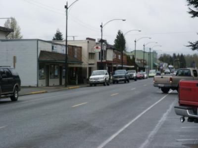

4 BACKGROUND: The City of Snoqualmie


5 BACKGROUND: The City of Snoqualmie
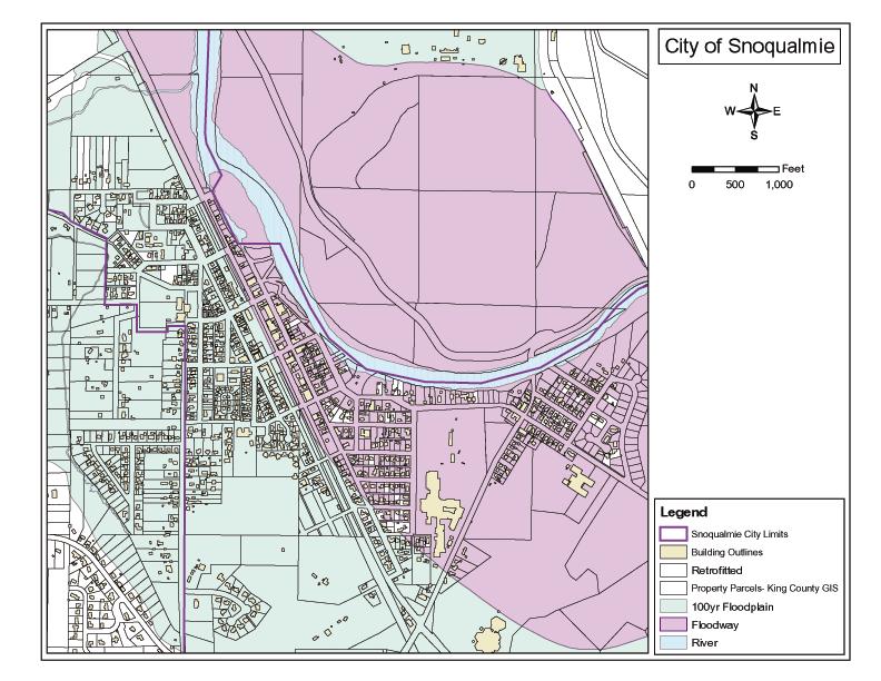
6 Floodplain - Floodway
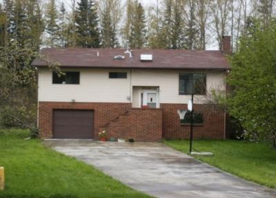
7 BACKGROUND: The City of Snoqualmie Non elevated, elevated and new elevated homes.


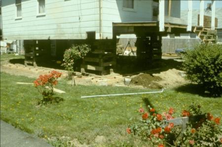
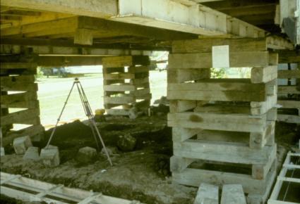

8 DISCUSSION: The Process of Retrofitting


9 DISCUSSION: The Process of Retrofitting


10 DISCUSSION: The Process of Retrofitting. Minimal value added -- no additional floor space.


11 DISCUSSION: The Process of Retrofitting Minimal value added -- no additional floor space


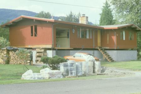
12 DISCUSSION: The Process of Retrofitting Value added -- Garage


13 DISCUSSION: The Process of Retrofitting Value added -- Floor space added above garage/carport.
14 Retrofitted


15 DISCUSSION: Elevation at time of construction
16 New Construction
17 Market Impacts on Elevated Homes Methodology

18 Homes Elevated and Sold
19 Sold
20 Market Impacts on Elevated Homes The results suggest that: When elevated homes are not perceived as being out of character with the neighborhood Non-elevated flood prone homes are discounted and The cost of the retrofitting approaches the value of the discount from expected market prices.
21 Market Impacts on Elevated Homes Questions: Is what is experienced in Snoqualmie true for other Riverine floodprone communities coastal communities? When do elevated homes begin to reflect the larger nonfloodprone community are there significant benchmarks, what factors are involved. What factors are considered by buyers sellers? What affect do appraisers have? What affect do real estate agents have? Buyer and seller perceptions?
22 A Reconnaissance Study on the Market Impacts on Elevated Homes in Known Floodplains City of Snoqualmie Case Study By Ron Throupe, Bob Freitag, Rhonda Montgomery
23 The Bottom Line The dollar value of home elevation reflected in the market is 50% of the average cost of elevation in today s dollars. If a home cost $35,000 in today s dollars to elevate a home, The home would return on average $17,463 dollars in a market value adjustment. Most of the homeowners elevated their homes through HMGP funds and were required to pay between 12.5 and 25 percent of the cost of elevation. Conclusion elevation is a sound investment for the property owner.

24 BACKGROUND: The City of Snoqualmie

25 Floodplain - Floodway

26 BACKGROUND: The City of Snoqualmie Non elevated, elevated and new elevated homes.
27 Retrofitted

28 New Construction

29 Sold
30 Snoqualmie,WA History of flood events Participates in the National Flood Insurance Program, NFIP Hazard Mitigation Grant program, HMGP Flood Mitigation Assistance Program, FMAP State sponsorships
31 Literature Flood zone discounts Knowledge of buyers of the floodplain Flood risk vs. actual flooding
32 Preliminary Research Value added Elevations perception Market acceptance Public Policy implications
33 Data Sales data from Jan 1998 to June sales Reduced sample, Ridge Community Tom Elevation variable
34 Rational Market Prices A B C Non floodplain home Floodplain home -- Pre FIRM, not elevated Floodplain home -- Pre FIRM, elevated Cost bases market price of home = $195,500 (145/sq.ft) Cost bases market price = $191,000 ("A" - Cost of Flood Insurance or (195,500-4,500)) ($360/Yr for 30yrs at 7% = $4,500) Cost Bases Market Price = 194,000 ("A" - Cost of Flood Insurance or (195,500-1,500)) ($120/Yr for 30yrs at 7% = $1, 500)
35 Market Prices Adjusted by Reconnaissance Study Results. A B C Non floodplain home Floodplain home -- Pre FIRM, not elevated Floodplain home -- Pre FIRM, elevated Cost bases market price of home = ($195,500) (C * cost of Flood Insurance) (194, ) Cost bases market price of home = $177,000 ("A" - Cost of Flood Insurance - perception of risk) ($194,000 $17,000 = $177,000) Cost bases market price of home = $194,000 ("A" - Cost of Flood Insurance - perception risk + betterments) ($120/Yr for 30yrs at 7% = $1, 500)
36 Results $17,463 value for elevation Represents approx 50% of costs to elevate
37 Policy Implications The state and federal agencies that support floodplain management can learn from this investigation in several ways. They can be confident that the moneys spent on elevation created usable dwellings. The sales price gain from elevation is within the cost of construction. The State of Washington is prevented from providing public investment for private gain. The community at large benefits and it represents a sound investment for the federal government lowering future insurance claims and demands on FEMA personnel. Coordination of federal and state programs to expedite elevation may be warranted. Although this has been a successful program in Snoqualmie, less than 15% of the homes affected have been elevated.
38 Further Study Additional communities Buyers depth of knowledge investigation of value added
The National Flood Insurance Program and Flood Insurance Rate Map for San Francisco. Presentation at Treasure Island Community Meeting
 The National Flood Insurance Program and Flood Insurance Rate Map for San Francisco Presentation at Treasure Island Community Meeting October 17, 2007 1 National Flood Insurance Program (NFIP) Overview
REAL ESTATE FLOOD DISCLOSURE PROGRAM & FLOOD MAP INFORMATION SERVICES
 REAL ESTATE FLOOD DISCLOSURE PROGRAM & FLOOD MAP INFORMATION SERVICES Lisa Foster, CFM, Floodplain Coordinator ldfoster@pinellascounty.org January 26, 2018 Why are you here? Save your clients money on
Gail Moldovan-Trujillo, ACSR,CPIW Hagan Hamilton Insurance 2012 NFIP Agency of the year Flood Insurance Specialist & Consultant
 Gail Moldovan-Trujillo, ACSR,CPIW Hagan Hamilton Insurance 2012 NFIP Agency of the year Flood Insurance Specialist & Consultant Flood Insurance regulations continue to change at a very rapid pace, therefore
FEMA FLOOD MAPS Public Works Department Stormwater Management Division March 6, 2018
 FEMA FLOOD MAPS Public Works Department Stormwater Management Division March 6, 2018 Presentation Overview FEMA National Flood Insurance Program (NFIP) FEMA Community Rating System (CRS) Flood Insurance
Sources of FEMA Funding
 ASFPM Nonstructural/Floodproofing Workshops Sources of FEMA Funding ASFPM Nonstructural/Floodproofing Committee Gene Barr, CFM Principal Project Manager Nonstructural Specialist Sources of FEMA Funding
ECONOMIC EVALUATION OF FLOODPLAIN MANAGEMENT AND FLOOD MITIGATION
 ECONOMIC EVALUATION OF FLOODPLAIN MANAGEMENT AND FLOOD MITIGATION CITY OF BIRMINGHAM, ALABAMA EDWIN REVELL, CFM FLOOD PLAIN ADMINISTRATOR DENISE PRUITT, CFM PROJECT PLANNER PRESENTATION OUTLINE 1. BACKGROUND/LOCATION
Disaster Insurance: Are States and Insurance Companies Prepared?
 Disaster Insurance: Are States and Insurance Companies Prepared? National Conference of State Legislatures 2015 Legislative Summit Roy Wright Deputy Associate Administrator for Insurance and Mitigation
Flood Analysis Memo. 629 Orangewood Dr. Dunedin, FL BFE = 21 ft
 Flood Analysis Memo Property Address 629 Orangewood Dr. In Partnership with: ** This property is NOT within a high-risk flood zone ** 629 Orangewood Dr. BFE = 21 ft This property is located in the FEMA
Resources for Disaster Recovery Terry Lunn Hazard Mitigation Division Director
 Georgia Emergency Management Agency Homeland Security Resources for Disaster Recovery Terry Lunn Hazard Mitigation Division Director March 21, 2016 Current Flood Mitigation Grant Opportunities Disaster
210 W Canal Dr Palm Harbor, FL 34684
 Flood Analysis Memo Property Address In Partnership with: ** This property is within a high risk flood zone ** BFE = 6 ft This property is located in the FEMA designated high-risk zone, Zone AE - an area
10526 Bermuda Isle Dr. Tampa, FL 33647
 Flood Analysis Memo Property Address In Partnership with: ** This property is NOT within a high-risk flood zone ** This property is located in a FEMA low-risk zone designated as Zone X - an area of minimal
Louisiana Flood Risk Coalition. Red River Valley Association 93 rd Annual Convention Bossier City, LA
 Louisiana Flood Risk Coalition Red River Valley Association 93 rd Annual Convention Bossier City, LA Louisiana Flood Risk Coalition National Flood Insurance Program Reauthorization & Reform Who We Are
Piloting LAMP from Stream to Sea
 Piloting LAMP from Stream to Sea FEMA s New Analysis and Mapping Procedures for Non-Accredited Levee Systems Presented by: Eric Simmons, CFM Senior Engineer, FEMA Region IX Presentation Outline Levee Issues
Using GISWeb to Determine Your Property s Flood Zone
 Using GISWeb to Determine Your Property s Flood Zone 1. In a new browser window, go to http://www.co.santacruz.ca.us/departments/geographicinformationsystemsgis.aspx 2. Click on GISWeb - GIS Mapping Application
10/5/2015. What Makes a Sound Floodplain Management Program? What are the Flood Problems in your Community?
 The Community Rating System (CRS) and Hazard Mitigation Planning Preparing Your Community Through Common Program Goals September 3, 2015 What Makes a Sound Floodplain Management Program? Know your community
ADVISORY BASE FLOOD ELEVATIONS (ABFEs)
") The Department of Homeland Security s Federal Emergency Management Agency is committed to helping communities that were impacted by Hurricanes Katrina and Rita rebuild safer and stronger. Following catastrophic
The Department of Homeland Security s Federal Emergency Management Agency is committed to helping communities that were impacted by Hurricanes Katrina and Rita rebuild safer and stronger. Following catastrophic
Community Coordination Meeting Sagadahoc County, Maine
 Community Coordination Meeting Sagadahoc County, Maine Risk MAP Study April 2, 2014 Agenda Welcome and Introductions Project Timeline Flood Hazard Analysis Recap Flood Risk Products Action: Hazard Mitigation
Changes to the National Flood Insurance Program: From Biggert-Waters. to Grimm-Waters. Click to edit Master title style
 Changes to the National Flood Insurance Program: From Biggert-Waters Click to edit Master title style to Grimm-Waters Click to edit Master subtitle style Thomas Ruppert Coastal Planning Specialist Florida
Floodplain Management. City Council Work Session April 16, 2013
 Floodplain Management City Council Work Session April 16, 2013 1 Discussion Agenda Flood Insurance Rate Changes Community Rating System Recommendation Floodplain Ordinance Enhancements Modifications Public
TS18 Mitigation Grant Application and Benefit Cost Analysis Development - Support Documentation - Governor s Hurricane Conference 2017
 TS18 Mitigation Grant Application and Benefit Cost Analysis Development - Support Documentation - Governor s Hurricane Conference 2017 Name Entity Your role with mitigation projects Your expectations /
National Flood Insurance Program. Jennifer Gilbert, CFM, ANFI New Hampshire NFIP State Coordinator
 National Flood Insurance Program Jennifer Gilbert, CFM, ANFI New Hampshire NFIP State Coordinator What is the National Flood Insurance Program? Created by Congress in 1968 Participating Communities voluntarily
10526 Bermuda Isle Dr. Tampa, FL 33647
 Flood Analysis Memo Property Address 10526 Bermuda Isle Dr. In Partnership with: ** This property is NOT within a high-risk flood zone ** 10526 Bermuda Isle Dr. BFE = 35 ft This property is located in
Community Rating System. National Flood Insurance Program
 National Flood Insurance Program Community Rating System A Local Official s Guide to Saving Lives Preventing Property Damage Reducing the Cost of Flood Insurance FEMA B-573 / May 2015 How the Community
FEMA s Hazard Mitigation Assistance Grant Programs. Jeff Ward, JSWA
 FEMA s Hazard Mitigation Assistance Grant Programs Jeff Ward, JSWA Hazard Mitigation Grant Program (HMGP) Overview HMGP Introduction and Summary Section 404 of the Stafford Act Administered by FEMA Funding:
REAL ESTATE FLOOD DISCLOSURE PROGRAM & FLOOD MAP INFORMATION SERVICES
 REAL ESTATE FLOOD DISCLOSURE PROGRAM & FLOOD MAP INFORMATION SERVICES Lisa Foster, CFM, Floodplain Coordinator ldfoster@pinellascounty.org January 26, 2018 Why are you here? Save your clients money on
Appendix B. A Comparison of the Minimum NFIP Requirements and the CRS
 A Comparison of the Minimum s and the CRS The Community Rating System provides credits for exceeding the minimum requirements of the National Flood Insurance Program (NFIP). Many local officials are not
Community Coordination Meeting. York County, Maine. Risk MAP Study
 Community Coordination Meeting York County, Maine Risk MAP Study January 9, 2014 Agenda Welcome and Introductions Project Timeline Flood Hazard Analysis Recap (Digital Conversion, Riverine and Coastal)
Granting Floodplain Development Variances: Things to Consider for Compliance in the NFIP
 Granting Floodplain Development Variances: Things to Consider for Compliance in the NFIP Flooding is Mississippi s number one natural disaster potential and as such, many of our communities have been proactive
Use of FEMA Non regulatory Flood Risk Products in Planning
 Use of FEMA Non regulatory Flood Risk Products in Planning Georgia Association of Floodplain Managers Annual Conference March 24, 2016 What are the Non regulatory Flood Risk products? Go beyond the basic
The New Maryland Model Floodplain Management Ordinance
 Department of the Environment The New Maryland Model Floodplain Management Ordinance MAFSM Conference October 21, 2010 Kevin G. Wagner Agenda Brief history/background What s driving new ordinances Introduction
REAL ESTATE FLOOD DISCLOSURE PROGRAM & FLOOD MAP INFORMATION SERVICES
 REAL ESTATE FLOOD DISCLOSURE PROGRAM & FLOOD MAP INFORMATION SERVICES Agenda 10:30-12:00 Flood Disclosure Program 12:00-12:30 Lunch 12:30-1:30 Flood Map Service Center Lisa Foster, CFM, Floodplain Coordinator
BRANDI GABBARD CHAIR, NATIONAL ASSOCIATION OF REALTORS INSURANCE COMMITTEE COUNCIL MEMBER, CITY OF ST. PETERSBURG, FL
 BUILDING CLIMATE RESILIENCE IN THE REAL ESTATE SECTOR BRANDI GABBARD CHAIR, NATIONAL ASSOCIATION OF REALTORS INSURANCE COMMITTEE COUNCIL MEMBER, CITY OF ST. PETERSBURG, FL RESILIENCY THE ABILITY TO PREPARE
Hazard Mitigation Overview
 Hazard Mitigation Overview Yahara Lakes Advisory Group April 28, 2011 1 Discussion Topics Recent flood losses and damages Hazard mitigation programs Project opportunities 2 Recent Flood Losses* Date May
ASFPM Partnerships for Statewide Mitigation Actions. Alicia Williams GIS and HMP Section Manager, Amec Foster Wheeler June 2016
 ASFPM Partnerships for Statewide Mitigation Actions Alicia Williams GIS and HMP Section Manager, Amec Foster Wheeler June 2016 Summary The Concept Leveraging Existing Data and Partnerships to reduce risk
Questions about the National Flood Insurance Program
 Questions about the National Flood Insurance Program Federal Emergency Management Agency (FEMA) Questions and Answers What is the National Flood Insurance Program (NFIP)? The NFIP is a Federal program
Bucks County, PA Flood Risk Review Meeting. November 2014
 Bucks County, PA Flood Risk Review Meeting November 2014 Agenda for Today Risk MAP Program overview Overview of non-regulatory Flood Risk Products and datasets Discuss mitigation action Technical overview
Many of the changes to the NFIP were recently revised on March 21, 2014 by the Homeowner Flood Insurance Affordability Act of 2014.
 F l oodawa r e ne swe e k Ma r c h19-ma r c h25 2017 Below is a summary of the topics we will discuss today. On July 6, 2012, the Biggert-Waters Flood Insurance Reform Act of 2012 was passed by Congress
Hazard Mitigation Grants. Technical Assistance Session Middlesex County, NJ December 7, 2011
 Hazard Mitigation Grants Technical Assistance Session Middlesex County, NJ December 7, 2011 Outline Purpose of Hazard Mitigation Hazard Mitigation Projects Hazard Mitigation Assistance Grant Programs Using
Chapter 7 Appendix B: National Flood Insurance Program Summary for Kaua'i County, 2015 Update
 Chapter 7 Appendix B: National Flood Insurance Program Summary for Kaua'i County, 2015 Update Topic Considerations Description INSURANCE SUMMARY STAFF RESOURCES How many NFIP policies are in Kaua i County?
Durham County Preliminary Flood Hazard Data Public Meeting. July 28, 2016
 Durham County Preliminary Flood Hazard Data Public Meeting July 28, 2016 Why Are We Here New flood hazard data has been released as Preliminary for Durham County Statutory Due Process for review/comments
National Flood Insurance Program (NFIP) and Flood Insurance Rate Map (FIRM) San Francisco Port Commission. October 23, 2007
 and Flood Insurance Rate Map (FIRM) San Francisco Port Commission. October 23, 2007") National Flood Insurance Program (NFIP) and Flood Insurance Rate Map (FIRM) San Francisco Port Commission October 23, 2007 Flood Insurance Rate Map (FIRM) FEMA manages the NFIP using a nationwide system
National Flood Insurance Program (NFIP) and Flood Insurance Rate Map (FIRM) San Francisco Port Commission October 23, 2007 Flood Insurance Rate Map (FIRM) FEMA manages the NFIP using a nationwide system
New Jersey Department of Environmental Protection. Five-Year Floodplain Management Work Plan
 New Jersey Department of Environmental Protection Five-Year Floodplain Management Work Plan September 30, 2004 I. State Authority New Jersey Department of Environmental Protection Five-Year Floodplain
Federal Emergency Management Agency
 Page 1 of 4 Issue Date: April 11, 2013 Case No.: DETERMINATION DOCUMENT COMMUNITY AND REVISION INFORMATION PROJECT DESCRIPTION BASIS OF REQUEST Town Of Stratford Fairfield County Connecticut NO PROJECT
School District Mitigation Planning 101 April 28 th 30 th 2014
 School District Mitigation Planning 101 April 28 th 30 th 2014 Kenneth A. Goettel Goettel & Associates Inc. 1732 Arena Drive Davis, CA 95618 (530) 750-0440 KenGoettel@aol.com What is Hazard Mitigation?
THE ECONOMIC ARGUMENT FOR AMPHIBIOUS RETROFIT CONSTRUCTION
 THE ECONOMIC ARGUMENT FOR AMPHIBIOUS RETROFIT CONSTRUCTION Elizabeth C. English Ph.D., A.M. ASCE Associate Professor School of Architecture University of Waterloo WHAT IS AMPHIBIOUS ARCHITECTURE? Amphibious
Planning Commission April 19, 2017 Erin Cooper, Floodplain Specialist Varda Blum, Floodplain Program Manger
 Public Hearing for Z-17-0001: Zoning Map Amendments to the Floodplain Overlay District & DC-17-0001: Land Use Code text amendments to the Floodplain regulations Planning Commission April 19, 2017 Erin
Welcome to a Silver Jackets Webinar
 Welcome to a Silver Jackets Webinar The CRS and Repetitive Loss Area Analysis (RLAA) For audio, Dial: 877 336-1839 Access code: 5884527 Security code: 4567 Visual 10.1 David A. Stroud, CFM Emergency &
Floodplain Management 101. Mississippi Emergency Management Agency Floodplain Management Bureau
 Floodplain Management 101 Mississippi Emergency Management Agency Floodplain Management Bureau Stafford Act The Stafford Disaster Relief and Emergency Assistance Act (Stafford Act) (Public Law 100-707)
Preliminary Work Map Release
 Coastal Mapping in New Jersey Preliminary Work Map Release Monmouth County, New Jersey June 14, 2013 Agenda Introduction and Purpose of Briefing Hurricane Sandy Advisory Base Flood Elevations Transitioning
Door County Floodplain Program Informational Meeting
 Door County Floodplain Program Informational Meeting Door County Land Use Services Department Wisconsin Department of Natural Resources January 15, 2018 Floodplain = Land affected by flood event with a
Changes Coming to the National Flood Insurance Program What to Expect. Impact of changes to the NFIP under Section 205 of the Biggert-Waters Act
 Changes Coming to the National Flood Insurance Program What to Expect Impact of changes to the NFIP under Section 205 of the Biggert-Waters Act Flood Risk Flood risks and the costs of flooding Weather
FEMA s Flood Map Modernization Preparing for FY09 and Beyond: Integrated Flood Data Update, Risk Assessment, and Mitigation Planning
 FEMA s Flood Map Modernization Preparing for FY09 and Beyond: Integrated Flood Data Update, Risk Assessment, and Mitigation Planning DRAFT CONCEPT PAPER June 1, 2007 Integrated Flood Data Update, Risk
LOCAL OFFICIALS MEETING Lake Wausau Physical Map Revision MARATHON COUNTY, WISCONSIN FEBRUARY 9, 2017
 LOCAL OFFICIALS MEETING Lake Wausau Physical Map Revision MARATHON COUNTY, WISCONSIN FEBRUARY 9, 2017 Welcome & Introduction Michelle Staff Floodplain Management Policy Coordinator, WDNR Michelle.Staff@Wisconsin.gov
HAZARD MITIGATION IN HISTORIC DISTRICTS. Louisette L. Scott AICP, CFM Director, Dept. Planning & Development Mandeville, LA January 31, 2018
 1 HAZARD MITIGATION IN HISTORIC DISTRICTS Louisette L. Scott AICP, CFM Director, Dept. Planning & Development Mandeville, LA January 31, 2018 Mandeville, LA 2 Mandeville is Located on the northshore of
Floodplain Remapping
 Floodplain Remapping Floodplain Remapping Why remap the regulatory floodplain? More accurate maps means more effective floodplain management and safer communities. Who is remapping the regulatory floodplain?
Interagency Nonstructural Flood Risk Management Workshop. Carey Johnson Kentucky Division of Water
 Interagency Nonstructural Flood Risk Management Workshop Carey Johnson Kentucky Division of Water Nonstructural Flood Risk Management Nonstructural floodproofing Elevation Relocation Buyout/acquisition
a) Ensure public safety through reducing the threats to life and personal injury.
 Ensure public safety through reducing the threats to life and personal injury.") SECTION VII: FLOODPLAIN DISTRICT 7-1 Statement Of Purpose The purposes of the Floodplain District are to: a) Ensure public safety through reducing the threats to life and personal injury. b) Eliminate
SECTION VII: FLOODPLAIN DISTRICT 7-1 Statement Of Purpose The purposes of the Floodplain District are to: a) Ensure public safety through reducing the threats to life and personal injury. b) Eliminate
Updates to Maine Coastal Flood Insurance Rate Maps (FIRM s): What a Local Official Should Know. Presented by: Steve Johnson, P.E.
: What a Local Official Should Know. Presented by: Steve Johnson, P.E.") Updates to Maine Coastal Flood Insurance Rate Maps (FIRM s): What a Local Official Should Know Presented by: Steve Johnson, P.E. Town Engineer October 4, 2018 Introduction Federal Emergency Management
Updates to Maine Coastal Flood Insurance Rate Maps (FIRM s): What a Local Official Should Know Presented by: Steve Johnson, P.E. Town Engineer October 4, 2018 Introduction Federal Emergency Management
David A. Stroud, CFM AMEC Earth & Environmental Raleigh, NC
 David A. Stroud, CFM AMEC Earth & Environmental Raleigh, NC Objectives Risk MAP background North Carolina s Risk MAP role Role of communication in Risk MAP Effective risk communication two examples Multi-hazard
IN THIS ISSUE SPRING FLOODS. Black River, Pocahontas, Arkansas
 IN THIS ISSUE April and May brought a series of severe storm events to Arkansas, causing extensive damage throughout the state. ANRC spoke with many of you, gathering information on damages, providing
Flood Plain Management Services (FPMS) Program
 Program") Flood Plain Management Services (FPMS) Program 2016 Winter Stakeholder Partnering Forum March 2016 Mario Beddingfield, P.E., CFM Hydraulic Engineer/FPMS Program Manager H&H/Water Control Branch U.S. Army
Flood Plain Management Services (FPMS) Program 2016 Winter Stakeholder Partnering Forum March 2016 Mario Beddingfield, P.E., CFM Hydraulic Engineer/FPMS Program Manager H&H/Water Control Branch U.S. Army
Floodplain Development Permit Application
 Floodplain Development Permit Application **All construction will also require a building permit** This is an application packet for a Floodplain Development Permit. Certain sections are to be completed
Planning Process---Requirement 201.6(b): An open public involvement process is essential to the development of an effective plan.
: An open public involvement process is essential to the development of an effective plan.") Section 3 Capability Identification Requirements Planning Process---Requirement 201.6(b): An open public involvement process is essential to the development of an effective plan. Documentation of the Planning
Section 3 Capability Identification Requirements Planning Process---Requirement 201.6(b): An open public involvement process is essential to the development of an effective plan. Documentation of the Planning
NFIP Mapping Issues. Wendy Lathrop, PLS, CFM. Cadastral Consulting, LLC
 NFIP Mapping Issues Cadastral Consulting, LLC NFIP Basic Objectives: Reduce the exposure to flood damages through the use of minimum standards for the placement and design of structures located in flood
CITY OF PLANTATION ENGINEERING DEPARTMENT INTEROFFICE MEMORANDUM NO
 CITY OF PLANTATION ENGINEERING DEPARTMENT INTEROFFICE MEMORANDUM NO. 2013-003 DATE: October 22, 2012 TO: Mayor and Members of City Council FROM: Brett W. Butler, PE, CFM City Engineer SUBJECT: CRS Program
Floodplain Management Annual Conference Atlanta, Georgia April 2017
 Floodplain Management 2017 Annual Conference Atlanta, Georgia April 2017 Floodplain Mapping and Flood Zones Zone Deisgnations: Zone A: No base flood elevations have been determined it is an approximated
Coordinating CRS Success on a County Scale. Presented at the 41st Annual ASFPM Conference Managing Flood Risk in the Heartland
 Coordinating CRS Success on a County Scale Presented at the 41st Annual ASFPM Conference Managing Flood Risk in the Heartland May 3, 2017 Today's Speaker Cynthia Bianco, CFM, AICP/PP Community Resiliency
Plan Maintenance Procedures
 PLAN MAINTENANCE PLAN MAINTENANCE PROCEDURES... 1 MONITORING AND EVALUATION... 2 PLAN MONITORING... 2 PLAN EVALUATION... 2 UPDATING... 2 PLAN AMENDMENTS... 2 FIVE (5) YEAR REVIEW... 3 INCORPORATION...
Changes to the National Flood Insurance Program: From Biggert to Grimm Waters. Click to edit Master title style. Click to edit Master subtitle style
 Changes to the National Flood Insurance Program: Click to edit Master title style From Biggert to Grimm Waters Click to edit Master subtitle style Thomas Ruppert Coastal Planning Specialist With thanks
Facts & Info regarding the NFIP in Mathews County VA And the Mathews County Floodplain Management Ordinance
 Facts & Info regarding the NFIP in Mathews County VA And the Mathews County Floodplain Management Ordinance As of 05-31-2014: Current NFIP policies in Mathews County = 1687 NFIP Claims= 1127, for a total
July 31, 2017 NFIP Flood Map Open House Flood Maps 101 Flood Mapping acronyms History of the NFIP Flood Mapping Updates Flood Insurance Fairhope,
 July 31, 2017 NFIP Flood Map Open House Flood Maps 101 Flood Mapping acronyms History of the NFIP Flood Mapping Updates Flood Insurance Fairhope, Alabama Flood Maps Fairhope Permitting Jurisdiction Coastal
Physical Map Revisions as a Result of Updated Coastal Flood Hazards
 Physical Map Revisions as a Result of Updated Coastal Flood Hazards Agenda Coastal Flood Hazard Analysis Recap Public Review and Appeal Period Effect on Existing Letters of Map Change Insurance Questions
Article 23-6 FLOODPLAIN DISTRICT
 AMENDING THE CODE OF THE CITY OF PITTSFIELD CHAPTER 23, ZONING ORDINANCE SECTION I That the Code of the City of Pittsfield, Chapter 23, Article 23-6 Floodplain District, shall be replaced with the following:
Flood Resistant Provisions of Connecticut s Newest Building Codes. Laura E. Ghorbi, PE, CFM Risk Management & Resilience
 Flood Resistant Provisions of Connecticut s Newest Building Codes Laura E. Ghorbi, PE, CFM Risk Management & Resilience October 25, 2017 Overview 2018 Connecticut State Building Code Adoption National
NFIP Overview Elevation Certificate Flood Insurance Rate Maps. By: Maureen O Shea, AICP, CFM State NFIP Coordinator
 NFIP Overview Elevation Certificate Flood Insurance Rate Maps By: Maureen O Shea, AICP, CFM State NFIP Coordinator Example of a flood failure Example of a flood failure Purposes of the NFIP Identify &
Bullitt County, Kentucky Preliminary DFIRM Community Open House. October 8, 2014 Shepherdsville, Kentucky
 Bullitt County, Kentucky Preliminary DFIRM Community Open House October 8, 2014 Shepherdsville, Kentucky Meeting Agenda Introductions Overview of Preliminary DFIRMs Overview of Map Appeal Process Questions
Passaic River Basin Flood Advisory Commission Report/Status of Recommendations. October 2014 Update
 Passaic River Basin Flood Advisory Commission Report/Status of Recommendations October 2014 Update Passaic River Basin Flood Advisory Commission April 2010: By Executive Order, Governor Christie created
Elevating Historic Properties
 Elevating Historic Properties HISTORIC PRESERVATION COMMISSION Guide The Mississippi Development Authority (MDA) has developed Elevation Design Guidelines to assist owners of all properties determined
Cameron County, TX. Consultation Coordination Officer (CCO) Meeting. Please sign in (sheet at front of the room) Meeting will begin at 9:00
 Meeting. Please sign in (sheet at front of the room) Meeting will begin at 9:00") Cameron County, TX Consultation Coordination Officer (CCO) Meeting Please sign in (sheet at front of the room) Meeting will begin at 9:00 July 29, 2015 Lisa Jennings FEMA Region 6 Roles & Responsibilities
Cameron County, TX Consultation Coordination Officer (CCO) Meeting Please sign in (sheet at front of the room) Meeting will begin at 9:00 July 29, 2015 Lisa Jennings FEMA Region 6 Roles & Responsibilities
Gerard S. Mallet, Local Mitigation Strategy Coordinator FLOODPLAIN MANAGEMENT PLAN PROGRESS REPORT
 Date: September 10, 2009 To: From: Subject: Charlotte County Board of County Commissioners Gerard S. Mallet, Local Mitigation Strategy Coordinator FLOODPLAIN MANAGEMENT PLAN PROGRESS REPORT Resolution
Flood Map Revisions. Town of Nags Head Public Information and Input Session. December 14, 2016, 6 pm
 Flood Map Revisions Town of Nags Head Public Information and Input Session December 14, 2016, 6 pm Flood Map Revisions New preliminary flood maps released for Dare County June 30, 2016 www.nagsheadnc.gov/floodmaps
National Flood Insurance Program (NFIP) for Real Estate Professionals
 for Real Estate Professionals") National Flood Insurance Program (NFIP) for Real Estate Professionals 1 Joshua Oyer, CFM Outreach Specialist NFIP State Coordinator s Office at the Texas Water Development Board 2 Outline Introduction
National Flood Insurance Program (NFIP) for Real Estate Professionals 1 Joshua Oyer, CFM Outreach Specialist NFIP State Coordinator s Office at the Texas Water Development Board 2 Outline Introduction
Federal Emergency Management Agency
 Page 1 of 4 Issue Date: April 26, 2013 DETERMINATION DOCUMENT COMMUNITY AND REVISION INFORMATION PROJECT DESCRIPTION BASIS OF REQUEST City of Coppell Dallas County Texas FILL HYDRAULIC ANALYSIS NEW TOPOGRAPHIC
Federal Emergency Management Agency
 Page 1 of 3 COMMUNITY AND MAP PANEL INFORMATION COMMUNITY CITY OF MARGATE CITY, ATLANTIC COUNTY, NEW JERSEY LEGAL PROPERTY DESCRIPTION A parcel of land, as described in Deed recorded in Book 4826, page
The National Flood Insurance Program A Model for Risk Management
 The National Flood Insurance Program A Model for Risk Management NFIP: U.S. Risk Management Model Risk Identification Risk Assessment Risk Insurance Risk Communication Risk Management (Mitigation) NFIP:
APRIL 2013 BIGGERT-WATERS SPECIAL EDITION
 News from Region X Inside this Issue April 2013 Volume 3, Issue 5 SPECIAL EDITION Biggert-Waters Reform Biggert-Waters Reform The National Flood Insurance Program (NFIP), administered by the Department
Dealing With Unnumbered A Zones in Maine Floodplain Management
 Dealing With Unnumbered A Zones in Maine Floodplain Management The following is a list of acceptable methods that the State Floodplain Management Coordinator and the Federal Emergency Management Agency
Levees: PL84-99 and the NFIP
 Levees: PL84-99 and the NFIP Tony D. Krause, P.E., CFM Flood Risk and Floodplain Management Omaha District US Army Corps of Engineers Objectives and Overview Objectives: Identify overlaps between Federal
Frequently Asked Questions and Answers Concerning Flood Insurance
 Frequently Asked Questions and Answers Concerning Flood Insurance Sources Used: (1) www.floodsmart.gov (2) National Flood Insurance Program, Answers to Questions about the NFIP, FEMA F-084/ March 2011.
Kentucky Risk MAP It s not Map Mod II
 Kentucky Risk MAP It s not Map Mod II Risk Mapping Assessment and Planning Carey Johnson Kentucky Division of Water carey.johnson@ky.gov What is Risk MAP? Risk Mapping, Assessment, and Planning (Risk MAP)
FEMA Leverages Building Codes and Standards to Advance Resiliency
 FEMA Leverages Building Codes and Standards to Advance Resiliency The goal of emergency management policy should be not just to respond but also to change the outcomes of natural hazards, and to do that,
Best Practices. for Incorporating Building Science Guidance into Community Risk MAP Implementation November 2012
 Best Practices for Incorporating Building Science Guidance into Community Risk MAP Implementation November 2012 Federal Emergency Management Agency Department of Homeland Security 500 C Street, SW Washington,
SECTION 9: MAPS AND DATA
 SECTION 9: MAPS AND DATA Contents 9.1. NFIP Maps and Data... 9-2 9.1.1. Adopting and enforcing NFIP floodplain maps and data... 9-2 9.1.2. Adopting and enforcing more restrictive data... 9-2 9.1.3. Annexations...
Erie County Flood Risk Review Meeting. January 18, 2018
 Erie County Flood Risk Review Meeting January 18, 2018 Agenda The value of updated flood maps for your community Review updated flood-risk data and important next steps in the Risk MAP process Increasing
Pinellas County Local Mitigation Strategy Progress Report
 Date: April 22, 2018 To: From: Subject: City of Commissioners Joseph A. DiPasqua, CBO, CFM, Assistant Director of Planning & Development Progress Report Background, Florida, and its 23 incorporated municipalities
HAZARD MITIGATION PLAN POINT OF CONTACT MUNICIPAL PROFILE
 HAZARD MITIGATION PLAN POINT OF CONTACT hankvb@entermail.net khorvath@kceinc.com MUNICIPAL PROFILE MUNICIPAL PARTICIPATION Compliance with the National Flood Insurance Program (NFIP) Topic 1. Staff Resources
Catharine Cyr Ransom. The Accord Group
 Catharine Cyr Ransom Principal The Accord Group Stafford Act Structured approach to disasters Partnership between local, state, Federal governments Authority resides with the President Individual Federal
Discovery Meeting: Middle Potomac- Catoctin Watershed. FEMA REGION III September 26, 2012 Rockville, MD and Fairfax, VA
 Discovery Meeting: Middle Potomac- Catoctin Watershed FEMA REGION III September 26, 2012 Rockville, MD and Fairfax, VA Agenda Introductions Purpose of This Meeting Discovery Process Community Rating System
Federal Flood Insurance Changes (National Flood Insurance Program NFIP)
") Federal Flood Insurance Changes (National Flood Insurance Program NFIP) Biggert-Waters (BW-12) Flood Insurance Reform Act 2012 HR 4348 Signed by the President on July 6, 2012 Public Works, Engineering
Federal Flood Insurance Changes (National Flood Insurance Program NFIP) Biggert-Waters (BW-12) Flood Insurance Reform Act 2012 HR 4348 Signed by the President on July 6, 2012 Public Works, Engineering
STATE OF MARYLAND FLOODPLAIN MANAGEMENT PLAN FIVE-YEAR WORK PLAN DRAFT SEPTEMBER, 2004
 STATE OF MARYLAND FLOODPLAIN MANAGEMENT PLAN FIVE-YEAR WORK PLAN DRAFT SEPTEMBER, 2004 Prepared by: Maryland Department of the Environment Wetlands and Waterways Program Flood Mitigation Division D R A