Welcome to a Silver Jackets Webinar
|
|
|
- Joleen James
- 5 years ago
- Views:
Transcription
1 Welcome to a Silver Jackets Webinar The CRS and Repetitive Loss Area Analysis (RLAA) For audio, Dial: Access code: Security code: 4567 Visual 10.1

2 David A. Stroud, CFM Emergency & Hazard Mitigation Lead for AMEC Foster Wheeler Environment & Infrastructure in Raleigh, NC Over 25 yrs experience in hazard mitigation planning, the National Flood Insurance Program (NFIP), and Community Rating System (CRS) 18 yrs as the Flood Training Coordinator for FEMA s CRS Program. 16 years, David was a primary instructor for CRS Course at the Emergency Management Institute (EMI) Currently a contractor to the CRS Program performing Activity 510 plan reviews and program assistance Bachelor and Master s Degree in Urban and Regional Planning from Ball State University in Indiana Visual 10.2

3 Repetitive Loss Properties and the CRS Visual 10.3
4 Repetitive Loss Properties and the CRS Overview Section 501 The Repetitive Loss List The Privacy Act Section 502 Repetitive Loss Category CRS requirements Section 503 Repetitive Loss Areas How to identify Section 504 Repetitive Loss Area Outreach Project Section 510 (512 b.) Repetitive Loss Area Analysis (RLAA) 5-step planning process See Coordinator s Manual, Pages Visual 10.4
5 Repetitive Loss Properties and the CRS 501.a. Repetitive Losses Repetitive loss: 2 claims greater than $1,000 in any 10 year period since 1978 Severe repetitive loss (SRL): Repetitive loss property with: Four claims greater than $5,000 or Two or more claims that are greater than the building s value Terminology Repetitive Loss: Any insurable building for which two or more claims of more than $1,000 were paid by the NFIP within any rolling 10-year period, since Two of the claims paid must be more than 10 days apart but, within 10 years of each other. A repetitive loss property may or may not be currently insured by the NFIP. Severe Repetitive Loss: As defined by the Flood Insurance Reform Act of 2004, SRLs are 1-4 family residences that have had four or more claims of more than $5,000 or at least two claims that cumulatively exceed the building s value. The Act creates new funding mechanisms to help mitigate flood damage for these properties. See Coordinator s Manual, Page Visual 10.5
6 Repetitive Loss Areas NFIP Repetitive Loss Properties 160,000 repetitive loss properties in US 70,000 currently insured (approximately 44%) 10,000 severe repetitive loss properties Historically, repetitive loss properties represent 1.3% of all NFIP policies Represent 15% 20% of all NFIP claims Approximately 5 million flood insurance policies in the US Visual 10.6
. Also Excel files with active policies and past claims.")
7 Repetitive Loss Properties 501.b. The Repetitive Loss List Applications or cycle visits: Ask your ISO/CRS Specialist for your repetitive loss data. Not a cycle or new application, ask FEMA or state for data. You will get the rep loss Excel file and PDF worksheets (AW-501). Also Excel files with active policies and past claims. 1 See Coordinator s Manual, Page Visual 10.7
8 The Privacy Act Repetitive Loss Properties Flood insurance data, including repetitive loss data, has Personally Identifiable Information (PII), such as the addresses of insured properties PII is protected under the Privacy Act of 1974 FEMA collects data with Names and/or Addresses (Policy Holders, Insurance Claims, Repetitive Loss Properties) Private Insurance Protect FEMA data when working locally with PPI Visual 10.8

9 Repetitive Loss Properties The Privacy Act: Working with FEMA data General or aggregated information not connected to a particular property may be made public. See Coordinator s Manual, Page Visual 10.9

10 The Privacy Act Repetitive Loss Properties General or aggregated information not connected to a particular property may be made public. See Coordinator s Manual, Page Visual 10.10
11 Repetitive Loss Properties 501.c. Updating the List Review each property for: Correct address In your community Actually 2 floods Removed or otherwise mitigated Documentation is key for updating!! See Coordinator s Manual, Pages Visual 10.11
12 Repetitive Loss Properties 501.c Updating the List Paperwork: Must review the list Correct and/or update the AW-501s Minimum: at application and cycle It is good idea to review the list annually See Coordinator s Manual, Page Visual 10.12
13 Repetitive Loss Properties 501.c Updating the List If changes to the repetitive loss list Signed CC-RL Corrected or updated AW-501s Signed transmittal sheet If no changes to the repetitive loss list Signed CC-RL See Coordinator s Manual, Page Visual 10.13
14 Repetitive Loss Properties 502 Repetitive loss category After correcting and updating the AW-501s Category A: No repetitive loss properties Category B: 1 49 repetitive loss properties Category C: 50+ repetitive loss properties See Coordinator s Manual, Page Visual 10.14
15 Repetitive Loss Properties 502 Repetitive loss category After correcting and updating the AW-501s Category A: No repetitive loss properties or whose repetitive loss properties all have been mitigated No requirements See Coordinator s Manual, Page Visual 10.15
16 Repetitive Loss Properties 502 Repetitive loss category After correcting and updating the AW-501s Category B: 1 49 repetitive loss properties Prepare a map of the repetitive loss area(s) Review and describe its repetitive loss problem, Prepare a list of the addresses of all properties with insurable buildings in those areas, and Undertake an annual outreach project to those addresses See Coordinator s Manual, Page Visual 10.16
17 Repetitive Loss Properties 502 Repetitive loss category After correcting and updating the AW-501s Category C: 50+ repetitive loss properties Prepare a map of the repetitive loss area(s) Review and describe its repetitive loss problem, Prepare a list of the addresses of all properties with insurable buildings in those areas, and Undertake an annual outreach project to those addresses Activity 510 RLAA or FMP credit See Coordinator s Manual, Page Visual 10.17
18 Repetitive Loss Properties 502.b. Effective dates Category changes when number of repetitive losses change Effective: (1) When crediting 510 (Floodplain Management Planning) (2) When modifying for a class increase (3) At the cycle visit Must meet new category requirements the following year See Coordinator s Manual, Page Visual 10.18
19 Repetitive Loss Areas 503 Repetitive loss areas At each visit, a Category B or C community must submit: (1) AW-501s (if needed) (2) Signed CC-RL (3) Map of repetitive loss areas (4) Describe the cause of the repetitive flooding (5) List of addresses and the number of buildings in each of the mapped areas (6) Undertake an annual outreach project to those addresses See Coordinator s Manual, Page Visual 10.19


20 503.a The Map Repetitive Loss Areas Series General Materials See Mapping Repetitive Loss Areas, Page 1 Visual 10.20
21 Repetitive Loss Areas The Privacy Act of 1974 Flood insurance data about private property, including repetitive loss properties, are protected under the Privacy Act. Personally identifiable Information such as the names or addresses of specific properties, whether they are covered by flood insurance or not, whether they have received flood insurance claims, or the amounts of such claims MAY NOT be released outside of local government agencies or to the public or used for solicitation or other purposes. Such information should be marked For internal use only. Protected by the Privacy Act of FEMA has a cover sheet that is helpful in reminding users about how to handle this sensitive information. General or aggregated information, such as total claims paid for a community or an area, or data not connected to a particular property MAY be made public. For example, a community may publish a map showing a repetitive loss area or a list of addresses in that area, provided that it does not show which individual addresses or parcels received flood insurance claim payments. See Mapping Repetitive Loss Areas, Page 2 Visual 10.21
22 Repetitive Loss Areas 1. Locate the properties on the updated rep loss list See Mapping Repetitive Loss Areas, Page 2 Visual 10.22

23 Repetitive Loss Areas 2. Locate nearby properties that received 1 insurance claim These are listed in the historical claims Excel file See Mapping Repetitive Loss Areas, Page 2 Visual 10.23

24 Repetitive Loss Areas 2. Locate nearby properties that received 1 insurance claim See Mapping Repetitive Loss Areas, Page 2 Visual 10.24
 layer to identify low")

25 Repetitive Loss Areas 3. If you have the capability, overlay a topographic map (GIS) layer to identify low areas 4. Draw lines around those areas with similarly situated properties: Same low elevation History of flood insurance claims Similar construction (i.e. slab on grade) See Mapping Repetitive Loss Areas, Page 3 Visual 10.25
26 Repetitive Loss Areas 4. Draw lines around those areas with similarly situated properties See Mapping Repetitive Loss Areas, Page 3 Visual 10.26

27 Repetitive Loss Areas 4. Draw lines around those areas with similarly situated properties See Mapping Repetitive Loss Areas, Page 3 Visual 10.27

28 Repetitive Loss Areas 5. Check the area in the field See if the buildings on FEMA s list are unique (e.g., only one(s) on slab at grade) See Mapping Repetitive Loss Areas, Page 3 Visual 10.28
29 Repetitive Loss Areas 5. Check the area in the field See if the buildings on FEMA s list are unique (e.g., only one(s) on slab at grade) See Mapping Repetitive Loss Areas, Page 3 Visual 10.29

30 Repetitive Loss Areas 6. A visit to the site helps confirm that the boundary makes sense See Mapping Repetitive Loss Areas, Page 3 Visual 10.30

31 Repetitive Loss Areas 6. A visit to the site helps confirm that the boundary makes sense See Mapping Repetitive Loss Areas, Page 3 Visual 10.31

32 Repetitive Loss Areas 7. If these remote ways to determine the repetitive loss area boundary don t explain why an area is flooded repeatedly, contact the property owners See Mapping Repetitive Loss Areas, Page 3 Visual 10.32


33 Repetitive Loss Areas 7. Contact the property owners Pool deck is 6 above the paved lanai surface. See Mapping Repetitive Loss Areas, Page 3 Visual 10.33

34 Repetitive Loss Areas 7. Contact the property owners See Mapping Repetitive Loss Areas, Page 3 Visual 10.34

35 Repetitive Loss Areas 8. If there is only one building in an area, document why If 100% on FEMA s list, use a large dot for the public map See Mapping Repetitive Loss Areas, Page 3 Visual 10.35

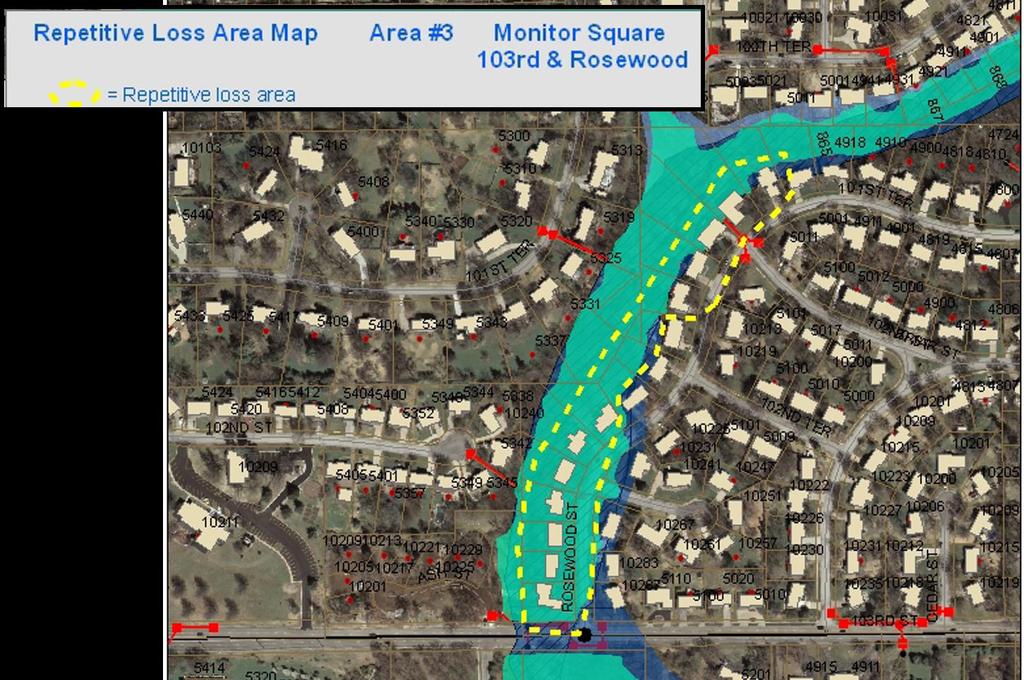
36 Repetitive Loss Areas Repetitive Loss Area # 1 15 total properties 2 repetitive loss properties 0 severe repetitive loss properties 1 historical claim 12 properties same or similar flood condition Problem: Slab on grade Diagram 1A See Mapping Repetitive Loss Areas, Page 3 Swale in back yards filled in with dirt and fences. No clear drainage path for water and limited outfall. Visual 10.36

37 Repetitive Loss Areas Visual 10.37

38 Repetitive Loss Areas Visual 10.38

39 Repetitive Loss Areas Some repetitive loss areas May be partially or fully in an X-Zone Visual 10.39

40 Repetitive Loss Areas 9. If a lot of repetitive losses spread throughout your community or floodplain, you can declare your entire community or floodplain to be a repetitive loss area. See Mapping Repetitive Loss Areas, Page 3 Visual 10.40
41 Repetitive Loss Areas The map the public sees must not show any individual properties on FEMA s repetitive loss list Prepare a list of the addresses of all improved parcels in the designated areas (private) Improved parcel = insurable building See Mapping Repetitive Loss Areas, Page 3 Visual 10.41
42 Repetitive Loss Areas 503 Repetitive loss areas At each visit, a Category B or C community must submit: (3) Map of repetitive loss areas (4) Describe the cause of the repetitive flooding (5) List of addresses and the number of buildings in each of the mapped areas (6) Undertake an annual outreach project to those addresses See Coordinator s Manual, Page Visual 10.42
43 Repetitive Loss Areas 504 Repetitive loss area outreach project Category B or C community must send out a notice that : (1) Says the property is in or near an area subject to flooding. (2) Explains property protection measures (3) Covers sources of financial assistance (4) Includes basic facts about flood insurance Send to ALL properties in rep loss AREAS Can be a targeted project or a PPI project Copy included with annual recertification See Coordinator s Manual, Page Visual 10.43
44 Repetitive Loss Areas Excerpt from sample outreach: Dear Resident: You have received this letter because your property is in an area that has been flooded several times. Our community is concerned about repetitive flooding and has an active program to help you protect yourself and your property from future flooding, but here are some things you can do: Check with the Building Department on the extent of past flooding in your area. Department staff can tell you about the causes of repetitive flooding, what the City is doing about it, and what would be an appropriate flood protection level. The staff can visit your property to discuss flood protection alternatives. 1. Prepare for flooding by doing the following: Know how to shut off the electricity and gas to your house when a flood comes. Make a list of emergency numbers and identify a safe place to go. Make a household inventory, especially of basement contents. Put insurance policies, valuable papers, medicine, etc., in a safe place. Collect and put cleaning supplies, camera, waterproof boots, etc., in a handy place. Develop a disaster response plan. See the Red Cross s website at for information about preparing your home and family for a disaster. Get a copy of Repairing Your Flooded Home. We have copies at the Public Works Department or it can be found on the Red Cross website, too. 2. Consider some permanent flood protection measures. Mark your fuse or breaker box to show the circuits to the floodable areas. Turning off the power to the basement before a flood can reduce property damage and save lives. Consider elevating your house above flood levels. See Coordinator s Manual, Page Visual 10.44
45 Summary Repetitive Loss Areas Repetitive loss property information is private and not for public distribution Map the repetitive loss area(s), do not show the individual properties Description of the flooding at each repetitive loss area Outreach must be sent to the repetitive loss area(s) annually (list of addresses) Visual 10.45

46 Activity 510 (Floodplain Management Planning) 510 Floodplain Management Planning Visual 10.46
47 Activity 510 (Floodplain Management Planning) Activity 510 Overview This activity credits the plans that examine strategies to reduce the adverse impact of floods on the community and help meet other community needs. Activity 510 Element a. Floodplain Management Planning (FMP) (up to 382 points) b. Repetitive Loss Area Analysis (RLAA) (up to 140 points) c. Natural Floodplain Functions Plan (NFP) (up to 100 points) Visual 10.47

48 Activity 510 (Floodplain Management Planning) 512.b. Repetitive Loss Area Analysis (RLAA) More in-depth plan for small area(s) Five step planning process 1. Advise all properties 2. Contact other agencies 3. Collect data on each building 4. Review alternative approaches 5. Document the findings See Coordinator s Manual, Pages Visual 10.48
49 Activity 510 (Floodplain Management Planning) 512.b. Credit criteria for the RLAA To receive credit for an RLAA, the following must occur: 1. At least one or more repetitive loss properties on FEMA s list and at least one area delineated according to Section 503 except for Category C communities One exception communities with no historic flood claims but are working to reduce repetitive flooding 2. An area analyses must have been prepared and adopted for each repetitive loss area The repetitive loss areas must be mapped as described in Section 503 If the community does not conduct an analysis of all the areas, credit will be pro-rated See Coordinator s Manual, Pages Visual 10.49
50 Activity 510 (Floodplain Management Planning) 512.b. Credit Criteria for the RLAA Five step planning process 1. Advise all properties 2. Contact other agencies 3. Collect data on each building 4. Review alternative approaches 5. Document the findings 3 Steps 2 through 4 can occur in any order See Coordinator s Manual, Pages Visual 10.50
51 Activity 510 (Floodplain Management Planning) 512.b. Credit Criteria for the RLAA Five step planning process 1. Advise all properties Upfront notification advising all properties in the repetitive loss areas will be conducted and request their input on the hazards and recommended actions. This notice cannot identify which properties are on FEMA s list. However, there are no restrictions on publicizing what properties are in repetitive loss AREAS that have more than one property See Coordinator s Manual, Pages Visual 10.51
52 Activity 510 (Floodplain Management Planning) 512.b. Credit Criteria for the RLAA Five step planning process 1. Advise all properties The notice can be sent to owners or residents at the community s discretion, as long as a representative of each property is notified The notice must indicate when and how residents can obtain copies of the draft report and make comments See Coordinator s Manual, Pages Visual 10.52

53 Activity 510 (Floodplain Management Planning) See Coordinator s Manual, Pages Visual 10.53
54 Activity 510 (Floodplain Management Planning) Q7: What do you feel was the cause of your flooding? Answer Choices Percentage Number Responding Storm sewer backup Sanitary sewer backup 2 3 Standing water next to house/building Drainage from nearby properties Saturated ground/leads in basement walls 7 9 Overbank flooding Other Total See Coordinator s Manual, Pages Visual 10.54
55 Activity 510 (Floodplain Management Planning) 512.b. Credit Criteria for the RLAA Five step planning process 1. Advise all properties The notice cannot be done via Newspaper Newsletter Article See Coordinator s Manual, Pages Visual 10.55

56 Activity 510 (Floodplain Management Planning) 512.b. Credit Criteria for the RLAA Five step planning process 2. Contact other agencies Contact agencies and organizations that may have data, plans or studies that could affect or the cause or impacts of the flooding In community and outside of community See Coordinator s Manual, Pages Visual 10.56

57 Activity 510 (Floodplain Management Planning) 512.b. Credit Criteria for the RLAA Five step planning process 2. Contact other agencies In community: Stormwater/Public Works/Planning & Development, CIP projects, HOA s, etc. Outside of communities: State NFIP Coordinator and Emergency Management, FEMA - FIS and Flood Risk Report, US Army Corps of Engineers, etc. See Coordinator s Manual, Pages Visual 10.57
58 Activity 510 (Floodplain Management Planning) 512.b. Credit Criteria for the RLAA Five step planning process 3. Collect data on each building Site visit must collect data sufficient to do a preliminary determination of the cause of repetitive flooding and the mitigation measures that would be appropriate - drainage patterns around the building - condition of the structure and foundation - Elevation of HVAC units - Guttering and downspouts - Nearby storm drains See Coordinator s Manual, Pages Visual 10.58


59 Activity 510 (Floodplain Management Planning) 512.b. Credit Criteria for the RLAA Five step planning process 3. Collect data on each building Site visit must collect data sufficient to do a preliminary determination of the cause of repetitive flooding and the mitigation measures that would be appropriate - drainage patterns around the building - condition of the structure and foundation - Elevation of HVAC units - Guttering and downspouts - Nearby storm drains See Coordinator s Manual, Pages Visual 10.59

60 Activity 510 (Floodplain Management Planning) 512.b. Credit Criteria for the RLAA Five step planning process 3. Collect data on each building The person collecting the data on the buildings should not have to enter the property Floor elevations or historical flood levels are not required but can be helpful The date and amount of insurance claims can be helpful in determining the type of damage to the building and amount of damage See Coordinator s Manual, Pages Visual 10.60


61 Activity 510 (Floodplain Management Planning) 512.b. Credit Criteria for the RLAA Five step planning process 3. Collect data on each building FEMA 551 can provide more information on appropriate mitigation measures for Floodprone structures Floor elevations or historical flood levels are not required but can be helpful Collecting and organizing data can be done using the limited data view of the National Flood Mitigation Data Collection Tool See Coordinator s Manual, Pages Visual 10.61

 See")

62 Activity 510 (Floodplain Management Planning) See Coordinator s Manual, Pages Visual 10.62


63 Activity 510 (Floodplain Management Planning) 512.b. Credit Criteria for the RLAA Five step planning process 3. Collect data on each building See Coordinator s Manual, Pages Visual 10.63
 512.b.")


64 Activity 510 (Floodplain Management Planning) 512.b. Credit Criteria for the RLAA Five step planning process 3. Collect data on each building See Coordinator s Manual, Pages Visual 10.64
 512.b.")


65 Activity 510 (Floodplain Management Planning) 512.b. Credit Criteria for the RLAA Five step planning process 3. Collect data on each building See Coordinator s Manual, Pages Visual 10.65
66 Activity 510 (Floodplain Management Planning) 512.b. Credit Criteria for the RLAA Five step planning process 4. Review alternative approaches Determine if any property protection measures or drainage improvements are feasible Always include purchase of flood insurance (structure and/or contents coverage) Different types of building construction may require different mitigation approaches At a minimum, the review must include the property protection measures listed in Figure and See Coordinator s Manual, Pages Visual 10.66


67 Activity 510 (Floodplain Management Planning) 512.b. Credit Criteria for the RLAA Five step planning process 4. Review alternative approaches See Coordinator s Manual, Pages Visual 10.67

68 Activity 510 (Floodplain Management Planning) 512.b. Credit Criteria for the RLAA Five step planning process 4. Review alternative approaches See Coordinator s Manual, Pages Visual 10.68
69 Activity 510 (Floodplain Management Planning) 512.b. Credit Criteria for the RLAA Five step planning process 5. Document the findings A separate analysis must be conducted for each area separate reports are preferred for each area Different building construction Different mitigation measures Different flooding characteristics See Coordinator s Manual, Pages Visual 10.69
 Area 2 Single-family crawlspace and slab on grade construction (local stormwater) Area 3 Coastal")
70 Activity 510 (Floodplain Management Planning) 512.b. Credit Criteria for the RLAA Five step planning process 5. Document the findings Area 1 Downtown historic buildings with basements (Riverine flooding) Area 2 Single-family crawlspace and slab on grade construction (local stormwater) Area 3 Coastal with some elevated buildings See Coordinator s Manual, Pages Visual 10.70
71 Activity 510 (Floodplain Management Planning) 512.b. Credit Criteria for the RLAA Five step planning process 5. Document the findings Process followed how property owners were included Problem statement with map of the affected area List or table showing basic information for each building Alternative approaches reviewed Action plan including Who is responsible When it will be completed How it will be funded See Coordinator s Manual, Pages Visual 10.71
72 Activity 510 (Floodplain Management Planning) 512.b. Repetitive Loss Area Analysis (RLAA) Credit criteria (1) Must have at least one repetitive loss area (2) Follow the five step process (3) Adopted by governing body and available to the public* (4) Annual evaluation report (5) Update by each CRS cycle visit * Privacy Act applies. Summary report may be needed. See Coordinator s Manual, Pages Visual 10.72
 Available at CRSresources.")
73 Activity 510 (Floodplain Management Planning) Developing a Repetitive Loss Area Analysis (RLAA) Available at CRSresources.org/500 See Coordinator s Manual, Pages Visual 10.73
74 Activity 510 (Floodplain Management Planning) 512.b. Repetitive Loss Area Analysis (RLAA) Credit points RLAA = 140 x number of buildings in analyses number of buildings in repetitive loss areas A RLAA must be developed for all repetitive loss areas to meet the Category C requirements. See Coordinator s Manual, Pages Visual 10.74
75 Activity 510 (Floodplain Management Planning) Questions? Visual 10.75
Developing a Repetitive Loss Area Analysis. for Credit under Activity 510 (Floodplain Management Planning) of the Community Rating System
 of the Community Rating System") for Credit under Activity 510 (Floodplain Management Planning) of the Community Rating System 2017 CONTENTS Section 1. Background...1 Purpose...1 Definition of Repetitibve Losses...2 Addressing Repetitive
for Credit under Activity 510 (Floodplain Management Planning) of the Community Rating System 2017 CONTENTS Section 1. Background...1 Purpose...1 Definition of Repetitibve Losses...2 Addressing Repetitive
CITY OF PLANTATION ENGINEERING DEPARTMENT INTEROFFICE MEMORANDUM NO
 CITY OF PLANTATION ENGINEERING DEPARTMENT INTEROFFICE MEMORANDUM NO. 2013-003 DATE: October 22, 2012 TO: Mayor and Members of City Council FROM: Brett W. Butler, PE, CFM City Engineer SUBJECT: CRS Program
FEMA FLOOD MAPS Public Works Department Stormwater Management Division March 6, 2018
 FEMA FLOOD MAPS Public Works Department Stormwater Management Division March 6, 2018 Presentation Overview FEMA National Flood Insurance Program (NFIP) FEMA Community Rating System (CRS) Flood Insurance
Repetitive Loss Area Revisit # 6 Walter Road Area Jefferson Parish
 Repetitive Loss Area Revisit # 6 Walter Road Area Jefferson Parish www.floodhelp.uno.edu Supported by FEMA Acknowledgement The compilation if this report was managed by Erin Patton, CFM, a UNO-CHART Research
David A. Stroud, CFM AMEC Earth & Environmental Raleigh, NC
 David A. Stroud, CFM AMEC Earth & Environmental Raleigh, NC Objectives Risk MAP background North Carolina s Risk MAP role Role of communication in Risk MAP Effective risk communication two examples Multi-hazard
National Flood Insurance Program (NFIP) Community Rating System (CRS) Together North Jersey Resilient Task Force Meeting
 Community Rating System (CRS) Together North Jersey Resilient Task Force Meeting") National Flood Insurance Program (NFIP) Community Rating System (CRS) Together North Jersey Resilient Task Force Meeting April 3, 2017 Marianne Luhrs, AICP FEMA R2 CRS Coordinator Visual Intro-1 CRS Program
National Flood Insurance Program (NFIP) Community Rating System (CRS) Together North Jersey Resilient Task Force Meeting April 3, 2017 Marianne Luhrs, AICP FEMA R2 CRS Coordinator Visual Intro-1 CRS Program
REAL ESTATE FLOOD DISCLOSURE PROGRAM & FLOOD MAP INFORMATION SERVICES
 REAL ESTATE FLOOD DISCLOSURE PROGRAM & FLOOD MAP INFORMATION SERVICES Lisa Foster, CFM, Floodplain Coordinator ldfoster@pinellascounty.org January 26, 2018 Why are you here? Save your clients money on
COMMUNITY CERTIFICATIONS
 OMB No. xxxxxxxx Expires: xxxxxxxx National Flood Insurance Program Community Rating System COMMUNITY CERTIFICATIONS D R A F T CRS COMMUNITY CERTIFICATIONS The following community certifications are part
Community Rating System. National Flood Insurance Program
 National Flood Insurance Program Community Rating System A Local Official s Guide to Saving Lives Preventing Property Damage Reducing the Cost of Flood Insurance FEMA B-573 / May 2015 How the Community
SECTION 9: MAPS AND DATA
 SECTION 9: MAPS AND DATA Contents 9.1. NFIP Maps and Data... 9-2 9.1.1. Adopting and enforcing NFIP floodplain maps and data... 9-2 9.1.2. Adopting and enforcing more restrictive data... 9-2 9.1.3. Annexations...
a) Ensure public safety through reducing the threats to life and personal injury.
 Ensure public safety through reducing the threats to life and personal injury.") SECTION VII: FLOODPLAIN DISTRICT 7-1 Statement Of Purpose The purposes of the Floodplain District are to: a) Ensure public safety through reducing the threats to life and personal injury. b) Eliminate
SECTION VII: FLOODPLAIN DISTRICT 7-1 Statement Of Purpose The purposes of the Floodplain District are to: a) Ensure public safety through reducing the threats to life and personal injury. b) Eliminate
Planning Process---Requirement 201.6(b): An open public involvement process is essential to the development of an effective plan.
: An open public involvement process is essential to the development of an effective plan.") Section 3 Capability Identification Requirements Planning Process---Requirement 201.6(b): An open public involvement process is essential to the development of an effective plan. Documentation of the Planning
Section 3 Capability Identification Requirements Planning Process---Requirement 201.6(b): An open public involvement process is essential to the development of an effective plan. Documentation of the Planning
Article 23-6 FLOODPLAIN DISTRICT
 AMENDING THE CODE OF THE CITY OF PITTSFIELD CHAPTER 23, ZONING ORDINANCE SECTION I That the Code of the City of Pittsfield, Chapter 23, Article 23-6 Floodplain District, shall be replaced with the following:
Changes in Criteria and Scoring for CRS Outreach Projects
 Changes in Criteria and Scoring for CRS Outreach Projects A Handout for the National Flood Insurance Program Community Rating System Many communities want to keep disseminating and obtaining CRS credit
REAL ESTATE FLOOD DISCLOSURE PROGRAM & FLOOD MAP INFORMATION SERVICES
 REAL ESTATE FLOOD DISCLOSURE PROGRAM & FLOOD MAP INFORMATION SERVICES Lisa Foster, CFM, Floodplain Coordinator ldfoster@pinellascounty.org January 26, 2018 Why are you here? Save your clients money on
DRAFT REPETITIVE LOSS AREA ANALYSIS
 DRAFT REPETITIVE LOSS AREA ANALYSIS City of Savannah, Georgia Development Services Department Prepared by: Amec Foster Wheeler Environment & Infrastructure, Inc. July 2015 Table of Contents 1 Repetitive
Public Meeting Impact of Hurricane Irma on Central Beach
 Public Meeting Impact of Hurricane Irma on Central Beach CITY OF NEW SMYRNA BEACH October 11, 2017 at 6:00 pm Presentation Outline Hurricane Irma Impacts Flooding Caused by Hurricane Irma Original Goals
FLOODPLAIN MANAGEMENT PLAN 2015 ANNUAL PROGRESS REPORT
 FLOODPLAIN MANAGEMENT PLAN 2015 ANNUAL PROGRESS REPORT Hinds County (Unincorporated) NFIP Community Number 280070 The 2015 Floodplain Management Plan Annual Progress Report on the progress made in implementing
Cameron County, TX. Consultation Coordination Officer (CCO) Meeting. Please sign in (sheet at front of the room) Meeting will begin at 9:00
 Meeting. Please sign in (sheet at front of the room) Meeting will begin at 9:00") Cameron County, TX Consultation Coordination Officer (CCO) Meeting Please sign in (sheet at front of the room) Meeting will begin at 9:00 July 29, 2015 Lisa Jennings FEMA Region 6 Roles & Responsibilities
Cameron County, TX Consultation Coordination Officer (CCO) Meeting Please sign in (sheet at front of the room) Meeting will begin at 9:00 July 29, 2015 Lisa Jennings FEMA Region 6 Roles & Responsibilities
ASFPM Partnerships for Statewide Mitigation Actions. Alicia Williams GIS and HMP Section Manager, Amec Foster Wheeler June 2016
 ASFPM Partnerships for Statewide Mitigation Actions Alicia Williams GIS and HMP Section Manager, Amec Foster Wheeler June 2016 Summary The Concept Leveraging Existing Data and Partnerships to reduce risk
Bucks County, PA Flood Risk Review Meeting. November 2014
 Bucks County, PA Flood Risk Review Meeting November 2014 Agenda for Today Risk MAP Program overview Overview of non-regulatory Flood Risk Products and datasets Discuss mitigation action Technical overview
An Example of a Program for Public Information
 National Flood Insurance Program Community Rating System An Example of a Program for Public Information Communities that participate in the Community Rating System of the National Flood Insurance Program
10/5/2015. What Makes a Sound Floodplain Management Program? What are the Flood Problems in your Community?
 The Community Rating System (CRS) and Hazard Mitigation Planning Preparing Your Community Through Common Program Goals September 3, 2015 What Makes a Sound Floodplain Management Program? Know your community
TIPS FOR PREPARING TO JOIN SYSTEM THE COMMUNITY RATING. Kristin Owen, AICP, CFM. VFMA Fall Workshops
 TIPS FOR PREPARING TO JOIN THE COMMUNITY RATING SYSTEM Kristin Owen, AICP, CFM 1 The Community Rating System (CRS) Voluntary program for communities participating in the NFIP Recognizes activities beyond
National Flood Insurance Program s Community Rating System:
 National Flood Insurance Program s Community Rating System: An Introduction and Discussion of the RDO Role: 1/2 Presentation - 1/2 Discussion Bill Lesser, Federal Insurance and Mitigation Administration,
Kevin Wagner Maryland Department of the Environment
 Kevin Wagner Maryland Department of the Environment Topics Overview of the National Flood Insurance Program (NFIP) Mapping Regulations Insurance Mitigation Community Rating System (CRS) Questions Know
Upper Joachim Creek Public Survey on Potential Flood Risk Reduction
 Upper Joachim Creek Public Survey on Potential Flood Risk Reduction This survey is intended to help the interagency planning committee to receive public feedback on specific flood risk reduction techniques,
Use of FEMA Non regulatory Flood Risk Products in Planning
 Use of FEMA Non regulatory Flood Risk Products in Planning Georgia Association of Floodplain Managers Annual Conference March 24, 2016 What are the Non regulatory Flood Risk products? Go beyond the basic
Floodplain Management Plan
 Floodplain Management Plan CITY OF FORT WORTH TFMA 2016 Spring Conference March 10, 2016 Agenda 1. Fort Worth Higher Standards (NFIP & CRS) 2. Floodplain Management Plan Overview and Results 3. Project
Walter Road Jefferson Parish Repetitive Loss Area Analysis
 Walter Road Jefferson Parish Repetitive Loss Area Analysis www.floodhelp.uno.edu Supported by FEM A Repetitive Loss Area Analysis Background Jefferson Parish Walter Road Area The National Flood Insurance
Facts & Info regarding the NFIP in Mathews County VA And the Mathews County Floodplain Management Ordinance
 Facts & Info regarding the NFIP in Mathews County VA And the Mathews County Floodplain Management Ordinance As of 05-31-2014: Current NFIP policies in Mathews County = 1687 NFIP Claims= 1127, for a total
Role of Disaster Insurance in Improving Resilience: An Expert Meeting The Resilient America Roundtable
 Role of Disaster Insurance in Improving Resilience: An Expert Meeting The Resilient America Roundtable National Academy of Science Washington, DC July 9, 2015 Roseville Demographics Primary population
DAUPHIN COUNTY REPETITIVE LOSS AREA ANALYSIS DRAFT
 DAUPHIN COUNTY REPETITIVE LOSS AREA ANALYSIS DRAFT MAY 16, 2018 Prepared for: Dauphin County Department of Community and Economic Development 112 Market Street 7 th Floor Harrisburg, PA 17101 Prepared
Mistakes on Elevation Certificates
 Mistakes on Elevation Certificates What is the Base Flood Elevation (BFE) & how do you determine it? FIRM Map Panel? Flood Insurance Study? o Profile Sheet o Floodway Data Chart o Stillwater Chart Community
Roberta Grove Senator Circle Repetitive Loss Area Analysis Update Houma, LA
 Roberta Grove Senator Circle Repetitive Loss Area Analysis Update Houma, LA April 2016 (Original Report Published June 2013) The University of New Orleans Center for Hazards Assessment, Response and Technology
Door County Floodplain Program Informational Meeting
 Door County Floodplain Program Informational Meeting Door County Land Use Services Department Wisconsin Department of Natural Resources January 15, 2018 Floodplain = Land affected by flood event with a
The National Flood Insurance Program and Flood Insurance Rate Map for San Francisco. Presentation at Treasure Island Community Meeting
 The National Flood Insurance Program and Flood Insurance Rate Map for San Francisco Presentation at Treasure Island Community Meeting October 17, 2007 1 National Flood Insurance Program (NFIP) Overview
Flood Vulnerability Assessment for Critical Facilities. Molly Woloszyn Lisa Graff, GISP, CFM
 Flood Vulnerability Assessment for Critical Facilities Molly Woloszyn Lisa Graff, GISP, CFM 2011 University of Illinois Board of Trustees. All rights reserved. For permission information, contact the Illinois
California Building Code and the NFIP. John Ingargiola, Senior Engineer FEMA Building Science Branch
 California Building Code and the NFIP John Ingargiola, Senior Engineer FEMA Building Science Branch CA Major Disaster Declarations and Federal Assistance $21 $21 $76 $78 7 declarations, 2004-2016, total
CRS UNIFORM MINIMUM CREDIT CALIFORNIA
 CRS UNIFORM MINIMUM CREDIT CALIFORNIA SUMMARY The Community Rating System (CRS) provides Uniform Minimum Credit (UMC) for certain state laws, regulations, and standards that support floodplain management
National Flood Insurance Program (NFIP) for Real Estate Professionals
 for Real Estate Professionals") National Flood Insurance Program (NFIP) for Real Estate Professionals 1 Joshua Oyer, CFM Outreach Specialist NFIP State Coordinator s Office at the Texas Water Development Board 2 Outline Introduction
National Flood Insurance Program (NFIP) for Real Estate Professionals 1 Joshua Oyer, CFM Outreach Specialist NFIP State Coordinator s Office at the Texas Water Development Board 2 Outline Introduction
East Hartford. Challenges
 East Hartford The Town of East Hartford is a suburban community of approximately 52,212 located east of the City of Hartford and west of the Town of Manchester. The Town covers slightly more than 18 square
HAZARD MITIGATION PLAN POINT OF CONTACT MUNICIPAL PROFILE
 HAZARD MITIGATION PLAN POINT OF CONTACT glendonboro@rcn.com glendonboro@rcn.com MUNICIPAL PROFILE MUNICIPAL PARTICIPATION Identify source of information, if different Topic from the one listed 1. Staff
Michael Taylor, PE, CFM Project Manager, AECOM August 25, 2015
 Promoting FEMA s Flood Risk Products in the Lower Levisa Watershed Michael Taylor, PE, CFM Project Manager, AECOM August 25, 2015 Agenda Study Background Flood Risk Product Overview AOMI and Mitigation
Maryland Model Floodplain Management Ordinance (May, 2014) MODEL NOTES
 MODEL NOTES") Maryland Model Floodplain Management Ordinance (May, 2014) MODEL NOTES The model floodplain management ordinance that most Maryland communities have used as the basis for their regulations since the early
Maryland Model Floodplain Management Ordinance (May, 2014) MODEL NOTES The model floodplain management ordinance that most Maryland communities have used as the basis for their regulations since the early
Bayou Cane Terrebonne Parish Repetitive Loss Area Analysis November 2015
 Bayou Cane Terrebonne Parish Repetitive Loss Area Analysis November 2015 The University of New Orleans Center for Hazards Assessment, Response and Technology (UNO-CHART) floodhelp.uno.edu Supported by
Discovery Meeting: Middle Potomac- Catoctin Watershed. FEMA REGION III September 26, 2012 Rockville, MD and Fairfax, VA
 Discovery Meeting: Middle Potomac- Catoctin Watershed FEMA REGION III September 26, 2012 Rockville, MD and Fairfax, VA Agenda Introductions Purpose of This Meeting Discovery Process Community Rating System
Resources for Disaster Recovery Terry Lunn Hazard Mitigation Division Director
 Georgia Emergency Management Agency Homeland Security Resources for Disaster Recovery Terry Lunn Hazard Mitigation Division Director March 21, 2016 Current Flood Mitigation Grant Opportunities Disaster
NFIP Overview Elevation Certificate Flood Insurance Rate Maps. By: Maureen O Shea, AICP, CFM State NFIP Coordinator
 NFIP Overview Elevation Certificate Flood Insurance Rate Maps By: Maureen O Shea, AICP, CFM State NFIP Coordinator Example of a flood failure Example of a flood failure Purposes of the NFIP Identify &
Urban Flooding in Illinois The Changing Face of Floods
 Urban Flooding in Illinois The Changing Face of Floods Chicago Albany Park Neighborhood June 2008 National Academies of Science Chicago, IL September 19, 2017 Welcome to Illinois Floods? Really? Illinois
Chehalis River Basin Basin-Wide Floodplain Management Assessment
 Chehalis River Basin Basin-Wide Floodplain Management Assessment November 30, 2014 French & Associates, LTD. 2601 Havelock Court Steilacoom, WA 98388 Chehalis River Basin Basin-Wide Floodplain Management
Outreach Projects. for Credit under the Community Rating System of the National Flood Insurance Program
 Outreach Projects for Credit under the Community Rating System of the National Flood Insurance Program 2017 CONTENTS Introduction...1 Step 1. Determine your Audiences...2 Step 2. Draft your Messages...4
JAXGIS FEMA Flood Hazard Mapping -- Frequently Asked Questions
 Flood Hazard Zone Designations Summary Zones starting with the letter 'A' (for instance, Zone A, Zone AE, Zone AH, Zone AO) denote a Special Flood Hazard Area, which can also be thought of as the 100-year
FREQUENTLY ASKED QUESTION ABOUT FLOODPLAINS Michigan Department of Environmental Quality
 FREQUENTLY ASKED QUESTION ABOUT FLOODPLAINS Michigan Department of Environmental Quality WHAT IS A FLOOD? The National Flood Insurance Program defines a flood as a general and temporary condition of partial
Abington Township Public Meeting
 Abington Township Public Meeting Flood Insurance Rate Map Update March 23, 2016 1 Meeting Agenda and Format Provide residents/property owners of Abington Township with information about the map update,
Winter Storm Jonas Hazard Mitigation Grant Program
 Winter Storm Jonas Hazard Mitigation Grant Program Avalon, Ocean City, Sea Isle City and Stone Harbor March 25, 2017 Sea Isle City April 1, 2017 Ocean City Today's Agenda Nor Easter Jonas Hazard Mitigation
National Capitol Region HAZUS User Group Call
 Listen to the recording here to follow along with the presentation: http://www.freeconferencecalling.com/recordings/recording.aspx?fileid=l AF3494_04252013070630062_1154707&bridge=697620&email=&account
Mill Creek Floodplain Proposed Bylaw Frequently Asked Questions
 Mill Creek Floodplain Proposed Bylaw Frequently Asked Questions Q: What is a Floodplain Bylaw? A: A Floodplain Bylaw is a flood hazard management tool to ensure future land use will be planned and buildings
Hazard Mitigation Overview
 Hazard Mitigation Overview Yahara Lakes Advisory Group April 28, 2011 1 Discussion Topics Recent flood losses and damages Hazard mitigation programs Project opportunities 2 Recent Flood Losses* Date May
HAZARD MITIGATION PLAN POINT OF CONTACT MUNICIPAL PROFILE
 HAZARD MITIGATION PLAN POINT OF CONTACT northcatasauquaema@yahoo.com scheirerg@gmail.com MUNICIPAL PROFILE MUNICIPAL PARTICIPATION Compliance with the National Flood Insurance Program (NFIP) Identify source
Repetitive Loss Area Revisit City of Liberty Oak Forest Neighborhood
 Repetitive Loss Area Revisit City of Liberty Oak Forest Neighborhood February 1, 2011 The University of New Orleans Center for Hazards Assessment, Response and Technology (UNO-CHART) www.floodhelp.uno.edu
Appendix B. A Comparison of the Minimum NFIP Requirements and the CRS
 A Comparison of the Minimum s and the CRS The Community Rating System provides credits for exceeding the minimum requirements of the National Flood Insurance Program (NFIP). Many local officials are not
National Flood Insurance Program. Summary of Coverage
 National Flood Insurance Program Summary of Coverage FEMA F-679 / November 2012 This document was prepared by the National Flood Insurance Program (NFIP) to help you understand your flood insurance policy.
HAZARD MITIGATION PLAN POINT OF CONTACT MUNICIPAL PROFILE
 HAZARD MITIGATION PLAN POINT OF CONTACT louise@windgap-pa.gov jeffreyyob@gmail.com MUNICIPAL PROFILE MUNICIPAL PARTICIPATION Compliance with the National Flood Insurance Program (NFIP) Identify source
Floodplain Management Assessment
 CHEHALIS RIVER BASIN Floodplain Management Assessment Master Report Final April, 2015 TABLE OF CONTENTS Executive Summary... 1 Introduction... 2 The Floodplain... 4 Floodplain Development... 4 Floodplain
New Jersey Department of Environmental Protection. Five-Year Floodplain Management Work Plan
 New Jersey Department of Environmental Protection Five-Year Floodplain Management Work Plan September 30, 2004 I. State Authority New Jersey Department of Environmental Protection Five-Year Floodplain
ROI for Joining CRS. Floodplain Management Association Conference. Sacramento, CA. September 2016
 ROI for Joining CRS Floodplain Management Association Conference Sacramento, CA September 2016 Agenda Joining CRS Challenges ROI Tips Wrap Up 1 FMA Conference What is CRS? Community Rating System Voluntary
The National Flood Insurance Program Community Rating System: An Introduction and Discussion of the RDO Role. October 2, :00-3:15 pm ET
 The National Flood Insurance Program Community Rating System: An Introduction and Discussion of the RDO Role October 2, 2014 2:00-3:15 pm ET Our Mission The National Association of Development Organizations
Pinellas County Local Mitigation Strategy Progress Report
 Date: April 22, 2018 To: From: Subject: City of Commissioners Joseph A. DiPasqua, CBO, CFM, Assistant Director of Planning & Development Progress Report Background, Florida, and its 23 incorporated municipalities
Preliminary DFIRM Community Coordination (PDCC) Meeting Gilchrist & Levy Counties, FL. April 30, 2015
 Meeting Gilchrist & Levy Counties, FL. April 30, 2015") Preliminary DFIRM Community Coordination (PDCC) Meeting Gilchrist & Levy Counties, FL April 30, 2015 Agenda 1. Introductions 2. Study Process and Timeline 3. Overview of Preliminary Products 4. Overview
Preliminary DFIRM Community Coordination (PDCC) Meeting Gilchrist & Levy Counties, FL April 30, 2015 Agenda 1. Introductions 2. Study Process and Timeline 3. Overview of Preliminary Products 4. Overview
CITY OF VESTAVIA HILLS
 CITY OF VESTAVIA HILLS FLOODPLAIN MANAGEMENT PLAN KICK-OFF MEETING MARCH 10, 2015 FLOODPLAIN MANAGEMENT PLANNING COMMITTEE Representative of the following categories Preventive Maintenance (e.g., codes)
Reconstruction Implications
 Federal Emergency Management Agency (FEMA) Recovery Guidance Advisory Base Flood Elevation (ABFE) of April 12, 2006 Reconstruction Implications Presentation to: City of New Orleans July 6 th, 2006 Lambert
Flood Plain Management Services (FPMS) Program
 Program") Flood Plain Management Services (FPMS) Program 2016 Winter Stakeholder Partnering Forum March 2016 Mario Beddingfield, P.E., CFM Hydraulic Engineer/FPMS Program Manager H&H/Water Control Branch U.S. Army
Flood Plain Management Services (FPMS) Program 2016 Winter Stakeholder Partnering Forum March 2016 Mario Beddingfield, P.E., CFM Hydraulic Engineer/FPMS Program Manager H&H/Water Control Branch U.S. Army
Federal Emergency Management Agency
 Page 1 of 4 Issue Date: August 1, 2012 Effective Date: December 13, 2012 Case No.: 12-06-0595P LOMR-APP Washington, D.C. 20472 LETTER OF MAP REVISION DETERMINATION DOCUMENT COMMUNITY AND REVISION INFORMATION
COMMUNITY RATING SYSTEM (CRS) October 28, 2013
 October 28, 2013") COMMUNITY RATING SYSTEM (CRS) October 28, 2013 SUE K. HOPFENSPERGER, CFM ISO/CRS SPECIALIST ASSOCIATION OF STATE FLOODPLAIN MANAGER CERTIFIED FLOODPLAIN MANAGER Location: Fernandina Beach, FL INSURANCE
COMMUNITY RATING SYSTEM (CRS) October 28, 2013 SUE K. HOPFENSPERGER, CFM ISO/CRS SPECIALIST ASSOCIATION OF STATE FLOODPLAIN MANAGER CERTIFIED FLOODPLAIN MANAGER Location: Fernandina Beach, FL INSURANCE
VFMA Workshop October 16, David M. Gunn, P.E., CFM Henrico County DPW
 VFMA Workshop October 16, 2014 David M. Gunn, P.E., CFM Henrico County DPW Agenda NFIP Virginia Statistics BW-12 GW-14 Community Actions Flood Damages are not the result of a Natural Disaster, They are
Planning Commission April 19, 2017 Erin Cooper, Floodplain Specialist Varda Blum, Floodplain Program Manger
 Public Hearing for Z-17-0001: Zoning Map Amendments to the Floodplain Overlay District & DC-17-0001: Land Use Code text amendments to the Floodplain regulations Planning Commission April 19, 2017 Erin
G318 Local Mitigation Planning Workshop. Module 2: Risk Assessment. Visual 2.0
 G318 Local Mitigation Planning Workshop Module 2: Risk Assessment Visual 2.0 Unit 1 Risk Assessment Visual 2.1 Risk Assessment Process that collects information and assigns values to risks to: Identify
HAZARD MITIGATION PLAN POINT OF CONTACT MUNICIPAL PROFILE
 HAZARD MITIGATION PLAN POINT OF CONTACT hankvb@entermail.net khorvath@kceinc.com MUNICIPAL PROFILE MUNICIPAL PARTICIPATION Compliance with the National Flood Insurance Program (NFIP) Topic 1. Staff Resources
Flood Hazards and Flood Risk, the Impact of a Changing Climate
 Flood Hazards and Flood Risk, the Impact of a Changing Climate Sally A. McConkey, P.E. CFM, D. WRE. Illinois State Water Survey June 14, 2017 Topics ISWS Coordinated Hazard Assessment and Mapping Program
Chapter 7 Appendix B: National Flood Insurance Program Summary for Kaua'i County, 2015 Update
 Chapter 7 Appendix B: National Flood Insurance Program Summary for Kaua'i County, 2015 Update Topic Considerations Description INSURANCE SUMMARY STAFF RESOURCES How many NFIP policies are in Kaua i County?
Modernization, FEMA is Recognizing the connection between damage reduction and
 EXECUTIVE SUMMARY Every year, devastating floods impact the Nation by taking lives and damaging homes, businesses, public infrastructure, and other property. This damage could be reduced significantly
in coordination with Peoria County, Planning and Zoning Department
 Prepared by Amec Foster Wheeler Environment & Infrastructure Hazard Mitigation and Emergency Management Program in coordination with Peoria County, Planning and Zoning Department The purpose of hazard
Volusia County Floodplain Management Plan 2012
 Volusia County Floodplain Management Plan 2012 Introduction The National Flood Insurance Program (NFIP) provides federally supported flood insurance in communities that regulate development in floodplains.
The Future of Floodplain Management in Kentucky
 The Future of Floodplain Management in Kentucky Outline Background Federal Reauthorization Regulation Changes Insurance Changes Disclaimer All changes discussed in this presentation are PROPOSED ONLY.
Best Practices. for Incorporating Building Science Guidance into Community Risk MAP Implementation November 2012
 Best Practices for Incorporating Building Science Guidance into Community Risk MAP Implementation November 2012 Federal Emergency Management Agency Department of Homeland Security 500 C Street, SW Washington,
City of St. Augustine. Floodplain Management Higher Standards Information
 City of St. Augustine Floodplain Management Higher Standards Information There are different regulations that communities can use to help protect existing and future development and natural floodplain
HAZARD MITIGATION PLAN POINT OF CONTACT MUNICIPAL PROFILE
 HAZARD MITIGATION PLAN POINT OF CONTACT manager@boroughoffreemansburg.org chief@boroughoffreemansburg.org MUNICIPAL PROFILE MUNICIPAL PARTICIPATION Compliance with the National Flood Insurance Program
Public Outreach Strategy
 Public Outreach Strategy The Hillsborough County Public Outreach program is a community wide effort and includes participants from all jurisdictions. This report illustrates a commitment by Hillsborough
HAZARD MITIGATION PLAN POINT OF CONTACT MUNICIPAL PROFILE
 HAZARD MITIGATION PLAN POINT OF CONTACT nazareth50em1@gmail.com jessicagteel@gmail.com MUNICIPAL PROFILE MUNICIPAL PARTICIPATION 3. Describe how the public will be engaged in the current planning process
5/25/2017. So why don t more communities participate in the Community Rating System (CRS)? Agenda. What is CRS? Community Rating System
? Agenda. What is CRS? Community Rating System") Floodplain Management Activities Flood Insurance Rates So why don t more communities participate in the Community Rating System (CRS)? Texas Floodplain Management Association 29 th Annual Spring Conference
Floodplain Management Activities Flood Insurance Rates So why don t more communities participate in the Community Rating System (CRS)? Texas Floodplain Management Association 29 th Annual Spring Conference
Findings/Debrief Meeting September 9, CDOT R4 Headquarters Big Thompson Conference Room W 10 th St. Greeley, CO 80634
 Findings/Debrief Meeting September 9, 2016 CDOT R4 Headquarters Big Thompson Conference Room 10601 W 10 th St. Greeley, CO 80634 Discovery Review & Outcome May 25 Discovery Meeting Summary Summarize Data
HAZARD MITIGATION PLAN POINT OF CONTACT MUNICIPAL PROFILE
 HAZARD MITIGATION PLAN POINT OF CONTACT stockpolice@rcn.com stockworks@rcn.com MUNICIPAL PROFILE MUNICIPAL PARTICIPATION Compliance with the National Flood Insurance Program (NFIP) Identify source of information,
Kentucky Risk MAP It s not Map Mod II
 Kentucky Risk MAP It s not Map Mod II Risk Mapping Assessment and Planning Carey Johnson Kentucky Division of Water carey.johnson@ky.gov What is Risk MAP? Risk Mapping, Assessment, and Planning (Risk MAP)
LOCAL HAZARD MITIGATION PLAN UPDATE CHECKLIST
 D LOCAL HAZARD MITIGATION PLAN UPDATE CHECKLIST This section of the Plan includes a completed copy of the Local Hazard Mitigation Checklist as provided by the North Carolina Division of Emergency Management.
DES MOINES CITY OF TWO RIVERS. Flooding Risk & Impact to Development
 DES MOINES CITY OF TWO RIVERS Flooding Risk & Impact to Development River System Des Moines Flood Protection Des Moines Flood Protection cont. Infrastructure Over 24 miles of levees 21stormwater pump stations
ADVISORY BASE FLOOD ELEVATIONS (ABFEs)
") The Department of Homeland Security s Federal Emergency Management Agency is committed to helping communities that were impacted by Hurricanes Katrina and Rita rebuild safer and stronger. Following catastrophic
The Department of Homeland Security s Federal Emergency Management Agency is committed to helping communities that were impacted by Hurricanes Katrina and Rita rebuild safer and stronger. Following catastrophic
HAZARD MITIGATION PLAN POINT OF CONTACT. MUNICIPAL PROFILE
 HAZARD MITIGATION PLAN POINT OF CONTACT alacko@walnutportpa.org MUNICIPAL PROFILE MUNICIPAL PARTICIPATION Compliance with the National Flood Insurance Program (NFIP) Topic 1. Staff Resources Is the Community
Chapter 5 Floodplain Management
 Chapter 5 Floodplain Management Contents 1.0 Introduction... 1 2.0 Floodplain Management and Regulation... 1 2.1 City Code... 1 2.2 Floodplain Management... 1 2.3 Level of Flood Protection... 2 2.3.1 Standard