Chapter 5 Floodplain Management
|
|
|
- Christian Fields
- 5 years ago
- Views:
Transcription
1 Chapter 5 Floodplain Management Contents 1.0 Introduction Floodplain Management and Regulation City Code Floodplain Management Level of Flood Protection Standard Level of Protection Higher Level of Protection National Flood Insurance Program Colorado Water Conservation Board Floodplain Development Regulations Unstudied or Unmapped Floodplains Sources of and Use of Existing Floodplain Information FEMA Flood Insurance Rate Maps (FIRMs) and Flood Insurance Study (FIS) Major Drainageways with FEMA Mapping in Woodland Park Woodland Park Drainage Master Plan and Stormwater Management Plan Other Floodplain Information Confirmation of Floodplain Data Construction in or Development Adjacent to Floodplains Floodway Floodplain Fringe and Encroachments Subdivision Platting and Floodplains Freeboard Requirements FEMA Map Revisions and Amendments General Conditional Letter of Map Revision (CLOMR) Conditional Letter of Map Revision Based on Fill (CLOMR-F) Letter of Map Revision (LOMR) Letter of Map Revision Based on Fill (LOMR-F) Conditional Letter of Map Amendment (CLOMA) Letter of Map Amendment (LOMA) Physical Map Revision Floodplain Study Guidelines Requirement Incorporation into Other Submittals Floodplain Study Outline Agency Review Requirements Conceptual Review Floodproofing March 2014 City of Woodland Park 5-i
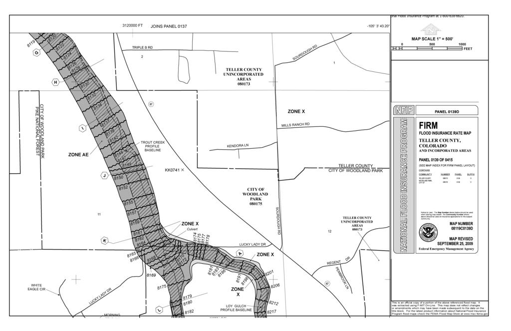
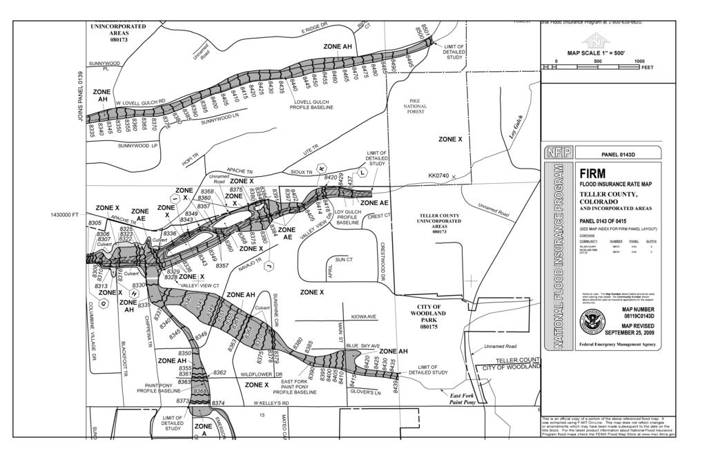
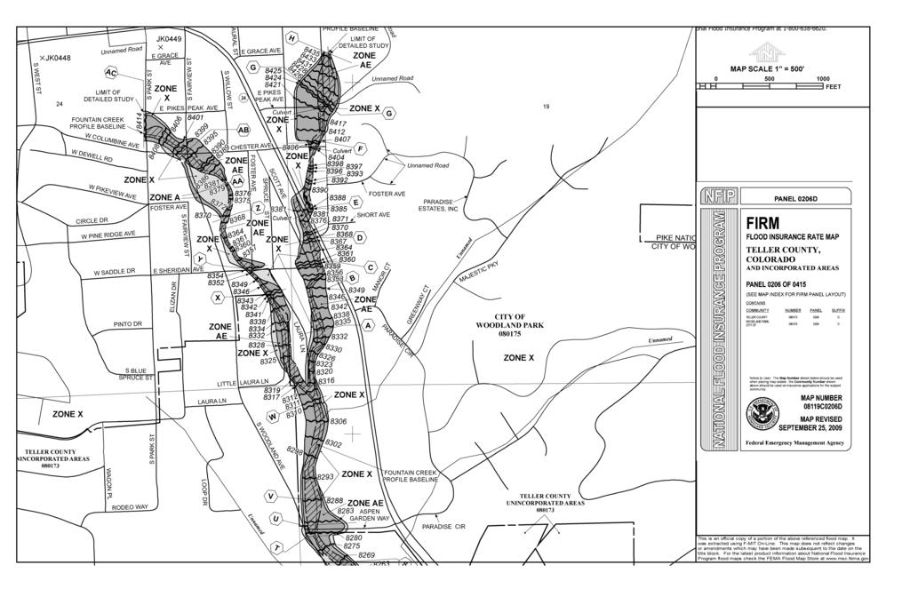
2 Floodplain Management Chapter 5 Figures Figure 5.1. Trout Creek Floodplain Near Northern City Limits Figure 5.2. Trout Creek Floodplain Including Confluence with Loy Gulch Figure 5.3. Loy Gulch Floodplain and Upper Trout Creek Figure 5.4. Loy Gulch, Paint Pony Creek and Lovell Gulch Floodplains Figure 5.5. Upper Trout Creek, Including Detailed (Zone AE) Mapping Figure 5.6. Upper Trout Creek Approximate (Zone A) Floodplain Mapping Figure 5.7. Upper Fountain Creek Floodplain Mapping Figure 5.8. Upper Fountain Creek Floodplain Mapping (Continued) ii City of Woodland Park March 2014
3 Chapter 5 Floodplain Management 1.0 Introduction Nature has claimed a prescriptive easement for floods, via its floodplains, that cannot be denied without public and private cost (White 1945). Flooding can result in loss of life, increased threats to public health and safety, damage to public and private property, damage to public infrastructure and utilities, and economic impacts to residents. In contrast, natural floodplains provide many benefits, including natural attenuation of flood peaks, water quality enhancement, groundwater recharge, wildlife habitat and movement corridors, and opportunities for recreation. Floodplains have been created and recreated over millennia and are the result of a complex interaction between hydrologic forces, vegetation, wildlife activity and geologic features. Changes to any of the factors that contribute to their natural function and dynamic adjustment to natural phenomenon may have far-reaching consequences and must be thoroughly evaluated. As a matter of public health and safety, it is desirable to minimize risks associated with potential flooding. The most effective means of minimizing these risks is to preserve flood-prone areas and to avoid alterations to flood flows and floodplains. This chapter describes policies, practices, and procedures for floodplain management. The requirements presented in this chapter apply to development within and adjacent to floodplains. 2.0 Floodplain Management and Regulation 2.1 City Code Title 20 of the Woodland Park Code of Ordinances (City Code) addresses Flood Damage Prevention Regulations, including the statutory authority and the basis for the regulations, administrative procedures for Flood Hazard Development Permits, variance procedures and procedures/requirements for flood hazard reduction. The City Code provides the basis for floodplain and floodway regulation in Woodland Park, and this chapter provides information that can be used to develop plans that will be compliant with the City Code. To the extent that there are differences between the recommendations in this chapter and the requirements of Title 20, Title 20 requirements shall prevail. 2.2 Floodplain Management Floodplain management is generally defined as a comprehensive program of preventative and corrective measures to reduce losses associated with flooding. Floodplain management measures may include, but are not limited to, land use regulations (including new development and construction policy), construction of flood control projects, floodproofing, floodplain preservation, acquisition of flood-prone properties, education, and implementation of early warning systems. These measures must be implemented in a consistent manner to be of value. Some of the objectives of floodplain management are to: Adopt effective floodplain regulations, Improve local land use practices, programs and regulations in flood-prone areas, Provide a balanced program of measures to reduce losses from flooding including floodplain and land use regulation, capital improvements, floodplain preservation, public education, flood insurance and others, March 2014 City of Woodland Park 5-1
4 Floodplain Management Chapter 5 Reduce reliance on local, state and federal disaster relief programs, Minimize water quality impacts, and Foster the creation or preservation of greenbelts, with associated wildlife and other ecological benefits. 2.3 Level of Flood Protection Standard Level of Protection The standard of practice, as defined by FEMA, requires implementation of floodplain management criteria within the regulatory 100-year (Base Flood) floodplain. The regulatory 100-year floodplain is the land area that will be inundated or flooded based on the stormwater runoff produced by the 100-year storm event as delineated on adopted FIRMs. The 100-year storm event is defined as the rainfall event that has a 1% probability of being equaled or exceeded in any given year. The flood flows used to determine floodplains shall be estimated using the methods defined in the Hydrology Chapter of this Manual, accepted published documents, and sources and methods otherwise approved by FEMA. Discharge flow rates in excess of the 100-year estimate can and will occur, but with lower probability. In those instances, the depth of flow and floodplain width will typically be greater than indicated on the floodplain maps. It is important to note that flooding occurs outside of the regulatory floodplains both beyond their width and upstream where mapping has not been provided. These areas must also be managed to preserve adequate space for flooding and to protect property and public safety Higher Level of Protection In some cases, a higher level of protection should be provided for flooding events in excess of the 100- year event. A higher level of protection should be considered for facilities and access routes that are critical for the protection of public health, safety, and welfare, or where flooding in excess of the 100-year storm event flooding is likely to result in loss of life, significant damage to utilities and infrastructure, or result in hazardous materials being transported in flood waters. The event for which protection should be provided should be determined on a case-by-case basis and be appropriate to the consequences of incurring the potential hazards. The Colorado Water Conservation Board (CWCB) has suggested that the 500-year flood event could be appropriate for evaluating risk to critical facilities. Critical facilities are structures or related infrastructure that, if flooded, may result in significant hazards to public health and safety or interrupt essential services and operations for the community at any time before, during and after a flood. 2.4 National Flood Insurance Program The National Flood Insurance Program (NFIP) is a federal program enabling property owners to purchase insurance protection against losses from flooding. Participation in the NFIP is based on an agreement between local communities and the federal government, which states that if a community will implement and enforce measures to reduce future flood risks to new construction in Special Flood Hazard Areas (SFHAs) or designated floodplains, the federal government will make flood insurance available within the community. In the past, the national response to flooding disasters was generally limited to constructing flood control projects and providing disaster relief to flood victims after a flood occurred. This did not reduce losses or discourage unwise development in flood-prone areas. Additionally, the 5-2 City of Woodland Park March 2014
5 Chapter 5 Floodplain Management public could not buy flood coverage from private insurance companies. Faced with mounting flood losses and escalating costs to the general taxpayers, Congress created the NFIP. The City of Woodland Park and Teller County participate in the NFIP and have agreed to adopt and enforce floodplain development regulations that meet or exceed the minimum outlined in 44 Code of Federal Regulations, Part 60. If the communities do not enforce the regulations that have been adopted, the community can be put on probation or suspended from the program. If suspended, the communities become non-participating and flood insurance policies cannot be written or renewed. 2.5 Colorado Water Conservation Board The CWCB is the State Coordinating Agency of the NFIP. The Flood Protection Program of the CWCB assists in the prevention of and recovery from flood disasters. The CWCB is responsible for technical review and approval of all reports and maps that are normally used by local governments for regulatory, floodplain administration, and insurance purposes. The CWCB review and approval process is officially known as floodplain designation. Designation and approval of the existing floodplain mapping enhance a community s ability to regulate 100-year floodplains more effectively. State enabling law for local zoning and subdivision regulation requires that technical information used for regulation of flood-prone areas be designated and approved by the CWCB. 2.6 Floodplain Development Regulations The governing regulation for floodplains within the City of Woodland Park is contained within Title 20 of the City of Woodland Park Municipal Code (City Code). The relationship between floodplains and development activity is also discussed in several other articles of Title 17 of the City Code, which addresses subdivision of land including preliminary and final plat requirements, and Title 18, which addresses zoning. The detailed requirements defined in the applicable codes are not reproduced in this chapter. For modifications to the SFHA and other floodplains regulated by the City, a Flood Hazard Development Permit is required. 2.7 Unstudied or Unmapped Floodplains There are a number of small channels and streams within the City that do not have FEMA-designated SFHAs. Some of these are headwaters reaches where FEMA mapping has not been extended all the way upstream. Typically FEMA maps floodplains for drainageways around urbanized areas that have a tributary drainage area of one square mile or greater. The potential for loss of life and/or property along these streams exists, just as it does along those channels or streams where floodplain limits or SFHAs have been identified. In general, these unstudied or non-regulatory floodplains will be managed in a similar manner as floodplains within the SFHAs. Management of these floodplains includes the preservation of right-of-way and natural features, and the mitigation of safety hazards. However, the FEMA process for mapping and map revision procedures is not required. A significant number of flood insurance claims result from areas outside of regulatory floodplains. By definition, flooding occurs whenever rainfall causes water to inundate the surface of the ground. While this occurs frequently without consequence, a failure to adequately accommodate these conditions can result in significant flood losses. Floodplain limits and water surface elevations must be determined for these unstudied drainageways when development, including but not limited to, home construction, channel modification, grading and earthmoving, other construction activities, or storage is proposed. In general, where floodplain March 2014 City of Woodland Park 5-3
6 Floodplain Management Chapter 5 information is unavailable, the applicant will be responsible for delineating the floodplain, based on fullydeveloped conditions in the watershed, consistent with the requirements outlined in this Manual. 3.0 Sources of and Use of Existing Floodplain Information 3.1 FEMA Flood Insurance Rate Maps (FIRMs) and Flood Insurance Study (FIS) The purpose of FIRMs is to identify flood-prone areas, by approximate or more detailed methods, and to establish flood risk zones for insurance rate purposes within those flood-prone areas. FIRMs are generally based on watershed conditions at the time the engineering analyses and accompanying survey were completed. In addition, detailed contour mapping may not have been available or used in the preparation of the original FIRMs. It is notable that there are differences between FIRMs and observed flood paths and some drainageway alignments in Woodland Park, and FIRM maps may not accurately reflect actual floodplains. In some cases modifications to drainageways have occurred that are not yet reflected on FIRMs. The information provided on the FIRMs and in the FIS is not based on consideration of changes that may have occurred since the study was completed or may occur due to future development in the watershed. Therefore, this information should not be solely relied upon as the actual limits of the 100-year floodplain or to identify areas prone to flooding. Further investigation of the assumptions, methodologies, and mapping that was used to produce the flood information on the FIRMs should be performed by a Professional Engineer registered in the State of Colorado. In some cases, the FIRMs are the only source of information available and can be used as an aid, but additional investigation and analyses may be required to define the actual floodplain limits on a particular parcel of land, especially when FIRMs are believed to be out-of-date and/or inaccurate. FIRMs, however, are the official regulatory maps published by FEMA for flood insurance purposes and, therefore, must be used when determining limits of the SFHA, and for complying with the floodplain regulations, as discussed previously. Important characteristics of FIRMs include: 1. Detailed Studies. FIRMs contain SFHA designations that were developed through a detailed study or by approximate methods. For drainageways that have a detailed study, Base Flood Elevations (BFEs, corresponding to 100-year water surface elevations) are provided on the maps and information is available in the FIS regarding floodplain and floodway widths, drainage areas, and peak discharges at select locations. In most cases, the BFEs can be used in conjunction with detailed topographic information to produce a reasonable estimate of the floodplain limits on a particular parcel of land, as long as it can be verified that the topographic information and the BFEs are referenced to the same vertical datum. 2. Approximate Zones. SFHA designations that were developed by approximate methods (Zone A) are generally less accurate and BFEs are not provided. Typically, there is no published information regarding peak flow rates used to calculate the approximate limits. As a result, making floodplain determinations and correctly delineating the floodplain on a specific property is more difficult. When a project is adjacent to a Zone A floodplain, floodplain limits must be developed using topographic mapping and an acceptable level of hydrologic and hydraulic analysis or a registered Professional Engineer must certify that flooding is unlikely. Procedures for making floodplain estimations in Zone A areas are outlined in the FEMA publication Managing Floodplain Development in Approximate Zone A Areas; however, the applicant s engineer should consult with the governing jurisdiction prior to selection of methodology or level 5-4 City of Woodland Park March 2014
7 Chapter 5 Floodplain Management of detail to confirm that they are reasonable and appropriate. 3. Map Revisions. FIRMs are often updated due to development or construction projects, changes in hydrology, the use of better topographic information, or other factors that affect the accuracy of the current SFHA limits. In most cases, the updates occur through a process called a Letter of Map Revision (LOMR). A LOMR provides revised floodplain information for a particular area, which supersedes the previous information and becomes the effective SFHA designation. However, the LOMR is a separate document, and the FIRMs typically are not re-published with the changes resulting from a revision. When reviewing FIRMs, it is important to determine whether any LOMRs have been completed for the area in question since these changes (LOMRs) may not yet be shown on the FIRM. 4. Map Availability. Current copies of the FIRMs and LOMR information are available for review in the office of the Floodplain Administrator. Maps can also be acquired through the FEMA Region 8 Office in Denver, or on-line at Figures for floodplains along major drainageways in Woodland Park are included as Figures 5-1 through 5-8 at the end of this chapter. Users of the Manual must check for current FEMA mapping, recent CLOMRs/LOMRs affecting reaches of interest and any updated hydrologic information since the date of the FIS. 3.2 Major Drainageways with FEMA Mapping in Woodland Park The City of Woodland Park has three major drainageways within its City limits. These drainageways include Trout Creek, which flows south to north, Fountain Creek which flows north to south, and Loy Gulch, a tributary of Trout Creek, which flows east to west. Per the FIS, Trout Creek drains a total area of approximately 24 square miles to the downstream City boundary shown on the FIRM and is a part of the South Platte River Basin. Tributaries of Trout Creek include Lovell and Loy Gulches. The drainage area is comprised of land uses including public, commercial, residential, and forest. According to the FIS, peak flows for the 10-yr, 50-yr, 100-yr, and 500-yr events are approximately 230 cfs, 340 cfs, 380 cfs, and 500 cfs, respectively. Trout Creek has an average gradient of 0.02 ft/ft (2 percent) through the City. Loy Gulch, a tributary of Trout Creek, drains a total area of approximately 6.6 square miles to the downstream City boundary shown on the FIRM, according to the FIS. The drainage area is comprised of land uses including commercial, residential, and forest. According to the FIS, peak flows for the 10-yr, 50-yr, 100-yr, and 500-yr events are approximately 90 cfs, 140 cfs, 160 cfs, and 200 cfs, respectively. Loy Gulch has an average gradient of 0.03 ft/ft (3 percent) through the City. Figures 5-1 through 5-6 provide effective FEMA floodplain mapping for Trout Creek and Loy Gulch as of the date of this Manual. Fountain Creek drains a total area of approximately 5.5 square miles to the downstream City boundary shown on the FIRM, according to the FIS. Fountain Creek, located within the Arkansas River Basin, is subject to more intense rainfall than Trout Creek, in the South Platte River Basin. The drainage area is comprised of land uses including agricultural, public, commercial, residential, and forest. According to the FIS, peak flows for the 10-yr, 50-yr, 100-yr, and 500-yr events are approximately 80 cfs, 120 cfs, 130 cfs, and 180 cfs, respectively. Fountain Creek has an average gradient of 0.03 ft/ft (3 percent) through the City. Figures 5-7 and 5-8 provide effective FEMA floodplain mapping for Fountain Creek as of the date of this Manual. March 2014 City of Woodland Park 5-5
8 Floodplain Management Chapter Woodland Park Drainage Master Plan and Stormwater Management Plan The City of Woodland Park worked with consultants to create the City of Woodland Park Drainage Master Plan and Stormwater Management Plan in These plans, which will periodically be updated by the City, define drainage and stormwater management planning for many portions of the City and should be referenced and consulted for proposed construction activities with potential to affect floodplains, drainage and/or stormwater quality management. The City is currently in the process of creating an updated city-wide drainage and stormwater master plan, and Applicants should be sure they are using the most current planning documents. 3.4 Other Floodplain Information Floodplain data may be obtained from other sources, including the Colorado Water Conservation Board, special districts that have completed floodplain studies and mapping, other local government initiated studies, and studies that have been prepared by private property owners or developers. In some cases, the information may be used as a basis for floodplain delineation for permitting and land development purposes, but the accuracy of all such information must be verified and the use of the information approved by the City. 3.5 Confirmation of Floodplain Data Prior to using any published floodplain information for design or planning purposes, the source of the data, accuracy, modeling methodology, assumptions, and other considerations must be investigated. Many factors can change floodplain limits; therefore, floodplain data is periodically updated to reflect changes due to floodplain modifications or the use of better technical data. The applicant is solely responsible for acquiring or developing accurate floodplain information for design and planning purposes. 4.0 Construction in or Development Adjacent to Floodplains The following sections identify the two areas within the SFHA floodplains with BFEs that are defined for regulatory purposes and discuss additional issues related to development adjacent to floodplains. 4.1 Floodway The floodway is defined as the stream channel and that portion of the floodplain that must be preserved in order to discharge the base flood without cumulatively increasing the water surface more than a designated height. The floodway is based on a maximum increase in the flood elevation of 1.0 foot. The floodway limits are typically generated through hydraulic modeling by assuming an equal loss of conveyance on both sides of the floodplain. The floodway can t be identified by visual inspection on a specific site or stream reach. The floodway is defined for regulatory purposes, and development in or use of the floodway is severely restricted. In most cases, projects that encroach upon the floodway require a no rise certification for existing structures, and conveyance improvements are needed to balance fill activities so that no rises in 100-year BFEs adversely affect insurable structures. It is notable that 1.0-foot rise floodways are being replaced by 0.5-foot-rise floodways as large map revision projects occur (typically Physical Map Revisions [PMRs] and not CLOMRs/LOMRs for specific reaches). Applicants should consult with the City Engineer and CWCB to determine applicable floodway rise criteria. 5-6 City of Woodland Park March 2014
9 Chapter 5 Floodplain Management 4.2 Floodplain Fringe and Encroachments The floodplain fringe is the portion of the 100-year floodplain that is not within the floodway. Although development and other forms of encroachment may be considered in the floodplain fringe, developers do not have an inherent right to fill in the floodplain fringe. Encroachments into the floodplain fringe reduce beneficial floodplain storage areas, and the cumulative effect of such encroachments can have significant impacts on downstream properties. Encroachment evaluations are only based on flood depth and do not consider impacts to channel stability as a result of increased channel velocity. Reduction of floodplain storage areas can increase peak flow rates and associated BFEs downstream, even though theoretically there may be limited impact at the site where the encroachment occurs. For this reason, encroachment into the floodplain fringe is contrary to the objective of minimizing damage to life and property and to the objective of maintaining floodplains as open space. Therefore, encroachments into the floodplain fringe are discouraged and will be considered on a case-bycase basis. When considering requests involving floodplain fringe encroachment, at a minimum, the following shall be considered: Impacts to adjacent properties. If the encroachment creates a rise in the BFE on properties other than that of the applicant, the applicant will be required to obtain floodplain easements for the additional floodplain property. FEMA typically will not allow any encroachment that causes a rise on an existing habitable structure. Channel hydraulics and design. If the encroachment creates a significantly narrow channel, with steep side slopes and undesirable velocities, mitigating channel improvements may be required, or the floodplain encroachment may not be supported. Channel stability, aesthetics and land use. If the fringe encroachment significantly impacts the functions, stability or aesthetics of the natural drainageway, and the resulting channel improvements create a drainageway that is not deemed compatible with the surrounding land uses, the floodplain fringe encroachment may not be supported. Threatened and Endangered Species. FEMA requires that the U.S. Fish and Wildlife Service (USFWS) sign-off for threatened and endangered species for CLOMRs. If there is no effect, the USFWS provides a letter of concurrence of no taking. If habitat for threatened and endangered species is affected, a CLOMR review may not begin until a permit is issued by the USFWS, which can delay the CLOMR and project schedule. 4.3 Subdivision Platting and Floodplains Platted lots should be located outside of the 100-year floodplain limits. Subdivision layout should also consider these factors: the size of the tributary watershed and higher degrees of protection where 500- year floodplains have been identified; the stability of the drainageway and anticipated improvements in the floodplain; access and trail requirements adjacent to the floodplain; the proximity of steep or vertical banks relative to the location of lot lines; the potential for the channel to migrate horizontally over time; the topography of the proposed lots; and the differences in elevation between the flooding elevation and potential structure locations. Lot lines should not be placed within or immediately adjacent to the floodplain limits without consideration of these factors. March 2014 City of Woodland Park 5-7
10 Floodplain Management Chapter 5 Additional considerations include: 1. Actual Floodplain Limits. The floodplain limits used for subdivision layout must be based on existing or proposed floodplain information that has been verified for accuracy, or floodplain limits must be developed through detailed hydrologic and hydraulic analyses, based on fullydeveloped conditions in the upstream watershed. 2. FEMA SFHAs. In addition to the physical floodplain limits, FEMA-designated SFHA boundaries must be considered in subdivision layout, where applicable. When the SFHA boundary accurately represents the proposed floodplain limits, lots should be platted so that they are outside of the SFHA. There are cases, however, where the SFHA is much wider than the actual or proposed floodplain. This situation frequently arises in locations where the SFHA was delineated using approximate methods or where improvements are proposed to confine the floodplain. In this case, platted lots should be outside of the SFHA and the actual floodplain, whichever is more restrictive. In some cases and only with the approval of the City Engineer, portions of platted lots that will not contain habitable structures (or significant obstructions to flow) may be within the SFHA. This would most typically be the case when detailed analysis shows a narrower floodplain and/or floodway than approximate or older FEMA mapping. Although outside of the actual floodplain, if lots are partially or totally within the SFHA, owners can be burdened with mandatory flood insurance purchase requirements. 4.4 Freeboard Requirements A minimum vertical clearance, or freeboard, shall be provided between the 100-year BFE and structures and other applicable facilities which may be impacted by the floodplain. Freeboard is required to allow for uncertainty in the floodplain modeling, changes to the drainageway (i.e., increased invert due to sedimentation or increased vegetation), and to provide an additional factor of safety for structures and facilities which would result in damages or hazards during inundation. A minimum of 1 foot of freeboard shall be provided between the 100-year BFE and the lowest finished floor elevation of all structures (this includes basements). The required freeboard should be contained within the floodplain tract and/or easement. For development/fill in an Approximate Flood Zone (Zone A), a minimum of 1.5 foot of freeboard shall be provided for structures unless detailed analysis is submitted and approved. For Critical Facilities, greater freeboard is recommended and may be required as a part of recent CWCB regulations that will be integrated into the City Code. 5.0 FEMA Map Revisions and Amendments 5.1 General FEMA FIRMs are the official regulatory maps that must be used for implementation and enforcement of the floodplain development regulations, which are generally discussed in this chapter. Additionally, the maps show projected flooding elevations, flood velocities, floodway dimensions, and flood risk zones used for insurance purposes. Maps must be updated to correct non-flood-related features, include analyses based on better ground elevation data, reflect changes in ground elevations within the floodplain, provide revised flooding data, and reflect flood control projects or other construction in the floodplain. Detailed information, revision request forms, technical requirements for map revisions or amendments, and construction requirements are included in the NFIP Regulations in 44 Code of Federal Regulations or are available through FEMA. The following sections provide brief descriptions of the various types of map revisions or amendments and how the requirements impact proposed projects. 5-8 City of Woodland Park March 2014
11 Chapter 5 Floodplain Management 5.2 Conditional Letter of Map Revision (CLOMR) A CLOMR is prepared to allow FEMA to comment on a proposed project or the use of better data that would affect the hydrologic or hydraulic characteristics of a flooding source and thus result in the modification of the existing regulatory floodway, BFEs, or SFHA limits. A CLOMR is required by FEMA, prior to construction, for projects or construction in the floodway that will result in an increase in the BFEs. At the discretion of the Floodplain Administrator, a CLOMR may also be required for other projects when it is important to ensure that the SFHA will be revised based on a proposed project or the use of better data. 5.3 Conditional Letter of Map Revision Based on Fill (CLOMR-F) A CLOMR-F is prepared to allow FEMA to comment on whether a proposed project involving the placement of fill outside of the regulatory floodway would exclude an area from the SFHA based on elevation. A detailed technical review generally is not required for a CLOMR-F application, as it primarily involves comparison of finished floor and lowest adjacent grades with. A CLOMR-F may also be required for a project when it is important to ensure that the SFHA will be revised based on a proposed project that involves fill in the floodplain fringe. 5.4 Letter of Map Revision (LOMR) A LOMR is an official revision, by letter, to an effective FIRM. A LOMR may change flood insurance risk zones, floodplain and/or floodway boundary delineations, planimetric features, and/or BFEs. The LOMR may be based on the use of better data or as-built conditions reflecting flood control or other construction projects. The LOMR must be completed and issued in order to revise the effective SFHA. 5.5 Letter of Map Revision Based on Fill (LOMR-F) A LOMR-F is a document issued by FEMA that officially removes a property and/or structure from the SFHA. A LOMR-F provides FEMA s determination concerning whether a structure or parcel has been elevated on fill above the BFE and excluded from the SFHA. 5.6 Conditional Letter of Map Amendment (CLOMA) A CLOMA is FEMA s comment on a proposed structure or group of structures that would, upon construction, be located on existing natural ground above the BFE. Generally, a CLOMA involves parcels, portions of parcels, or individual structures that were inadvertently included in the SFHA. 5.7 Letter of Map Amendment (LOMA) A LOMA is a document issued by FEMA that officially removes a property and/or structure from the SFHA. A LOMA establishes a property s or structure s location in relation to the SFHA. 5.8 Physical Map Revision (PMR) A PMR is an official republication of a map to change flood insurance zones, floodplain delineations, flood elevations, floodways, and planimetric features. A community can submit scientific and technical data to FEMA to support the request for a map revision. The data will be analyzed, and the map will be revised if warranted. March 2014 City of Woodland Park 5-9
12 Floodplain Management Chapter Floodplain Study Guidelines 6.1 Requirement When a project will modify the SFHA or any other floodplain regulated by the City, a Flood Hazard Development Permit is required, which must be supported by a floodplain study. This section presents general guidelines for preparing a floodplain study. Activities or projects that may potentially affect floodplains are not limited to new development. Other activities include, but are not limited to, bridge or culvert construction, utility installation, channel stabilization projects, trail crossing construction, and proposed storage of equipment or materials. 6.2 Incorporation into Other Submittals In some cases, the floodplain study will be an independent document; however, the floodplain study results are often incorporated into drainage reports for development projects or form the basis for CLOMR or LOMR submittals to FEMA. 6.3 Floodplain Study Outline A floodplain study must be certified by a Professional Engineer registered in the State of Colorado. The study must address the following items through detailed analysis or through reference to the current drainage master plan: 1. A description of the site. 2. A description of the major drainage basin. 3. The identification of drainage master plan reports, Flood Hazard Area Delineation (FHAD) studies, or FISs with a discussion of the applicability of published information or data to the proposed activity or modification. 4. Hydrologic analysis, including a narrative on the source of peak flow rates used for design. The flow rates used should be those generated for each storm event included in previous studies under future or revised development conditions for the entire watershed, unless the floodplain modification study is for a CLOMR/LOMR application, in which case, the FIS discharges should be used. 5. Characteristics of the proposed channel including, but not limited to, slope, roughness, depth, velocity, Froude Number, centerline alignment and stationing, and cross-sections. Existing topographic mapping may be utilized if it has been field-verified to determine that it has not changed significantly since mapping. The profile and plan shall be given for existing conditions and for the proposed channel alignment, including the cross-section locations. 6. A description of the method of hydrologic and/or hydraulic analysis (such as HEC-HMS or HEC- RAS) and its application in the study. 7. Identification and discussion of all input parameters and basis for input parameters. 8. Discussion of the results and conclusions of the hydraulic analysis. This shall include a narrative summary of the results, printed comprehensive output file free of modeling errors, and an electronic file of the modeling effort for review City of Woodland Park March 2014
13 Chapter 5 Floodplain Management 9. The delineation of the existing and proposed floodplains and water surface profiles for both conditions, including cross-section locations. 10. A description of potential impacts to other properties in the vicinity of the modification or activity and to downstream properties adjacent to the floodplain. 11. A description of measures proposed to mitigate potential impacts. 12. A conceptual design for the channel including bank protection, drop structures, culverts, bridges, and hardened trickle channel or low-flow channel. 13. A channel stability analysis if there is a change to the hydraulic characteristics of the drainageway or the stability of the bed and banks or if there is a change to the soils. This may include an analysis of sediment transport and fluvial morphology. 6.4 Agency Review Requirements Requests to modify the floodplain must be reviewed by multiple agencies, depending on the existing mapping of the flood hazard area and the extent of the modifications proposed, but in general conformance with the following: 1. City of Woodland Park. Issues related to floodplain management should be coordinated with any land use applications to the Planning Department and the Woodland Park City Engineer. 2. CWCB. The CWCB is the State Coordinating Agency of the NFIP and is responsible for technical review and approval of all reports and maps that are normally used by local governments for regulatory, floodplain administration, and insurance purposes. 3. FEMA. FEMA administers the NFIP. FEMA publishes Flood Hazard Boundary Maps and FIRMs that show floodplain boundaries for major drainageways. FEMA reviews applications to modify these FEMA designated floodplains. Floodplain modifications that impact a FEMAdesignated floodplain must be submitted to FEMA for review and approval via a CLOMR/LOMR process. 6.5 Conceptual Review Floodplain modifications must be permitted and approved by the agencies listed previously, depending on the proposed modification and site location. All projects or proposed modifications should be discussed with these agencies, in concept, prior to commencement of efforts required to produce the floodplain study. 7.0 Floodproofing In areas where structures may be within an existing floodplain or where local flooding may be expected, floodproofing can provide protection against flooding or reduce flood damage. For more information on floodproofing, see the technical bulletins provided by FEMA as part of the NFIP and Volume 2 of the UDFCD Manual. March 2014 City of Woodland Park 5-11
14
15

16 Figure 5.3 Loy Gulch Floodplain and Upper Trout Creek
17
18
19
20
21
Chapter 6 - Floodplains
 Chapter 6 - Floodplains 6.1 Overview The goal of floodplain management is to reduce the potential risks to both existing and future developments, and infrastructure, in the 100-year floodplain. Over the
FREQUENTLY ASKED QUESTION ABOUT FLOODPLAINS Michigan Department of Environmental Quality
 FREQUENTLY ASKED QUESTION ABOUT FLOODPLAINS Michigan Department of Environmental Quality WHAT IS A FLOOD? The National Flood Insurance Program defines a flood as a general and temporary condition of partial
INSTRUCTIONS FOR COMPLETING THE APPLICATION FORMS FOR CONDITIONAL LETTERS OF MAP REVISION AND LETTERS OF MAP REVISION
 INSTRUCTIONS FOR COMPLETING THE APPLICATION FORMS FOR CONDITIONAL LETTERS OF MAP REVISION AND LETTERS OF MAP REVISION GENERAL In 1968, the U.S. Congress passed the National Flood Insurance Act, which created
CRISP COUNTY, GEORGIA AND INCORPORATED AREAS
 CRISP COUNTY, GEORGIA AND INCORPORATED AREAS Community Name Community Number ARABI, CITY OF 130514 CORDELE, CITY OF 130214 CRISP COUNTY (UNINCORPORATED AREAS) 130504 Crisp County EFFECTIVE: SEPTEMBER 25,
SECTION 9: MAPS AND DATA
 SECTION 9: MAPS AND DATA Contents 9.1. NFIP Maps and Data... 9-2 9.1.1. Adopting and enforcing NFIP floodplain maps and data... 9-2 9.1.2. Adopting and enforcing more restrictive data... 9-2 9.1.3. Annexations...
NFIP Mapping Issues. Wendy Lathrop, PLS, CFM. Cadastral Consulting, LLC
 NFIP Mapping Issues Cadastral Consulting, LLC NFIP Basic Objectives: Reduce the exposure to flood damages through the use of minimum standards for the placement and design of structures located in flood
Floodplain Management 101. Mississippi Emergency Management Agency Floodplain Management Bureau
 Floodplain Management 101 Mississippi Emergency Management Agency Floodplain Management Bureau Stafford Act The Stafford Disaster Relief and Emergency Assistance Act (Stafford Act) (Public Law 100-707)
JAXGIS FEMA Flood Hazard Mapping -- Frequently Asked Questions
 Flood Hazard Zone Designations Summary Zones starting with the letter 'A' (for instance, Zone A, Zone AE, Zone AH, Zone AO) denote a Special Flood Hazard Area, which can also be thought of as the 100-year
Technical Memorandum 3.4 E Avenue NW Watershed Drainage Study. Appendix E Floodplain Impacts and Implications Memo
 Technical Memorandum 3.4 E Avenue NW Watershed Drainage Study Appendix E Floodplain Impacts and Implications Memo September 8, 2017 City of Cedar Rapids E Avenue Watershed Drainage Study Memo Date: Tuesday,
Article 23-6 FLOODPLAIN DISTRICT
 AMENDING THE CODE OF THE CITY OF PITTSFIELD CHAPTER 23, ZONING ORDINANCE SECTION I That the Code of the City of Pittsfield, Chapter 23, Article 23-6 Floodplain District, shall be replaced with the following:
Table 1: Federal, State and Local Government Rules applicable to LOMRs/CLOMRS submittal
 MnDNR LOMC Guide This document has been prepared by the Minnesota Department of Natural Resources floodplain staff and is intended to provide assistance with LOMR/CLOMR submittals. This information is
CHAPTER 15: FLOODPLAIN OVERLAY DISTRICT "FP"
 CHAPTER 15: FLOODPLAIN OVERLAY DISTRICT "FP" SECTION 15.1 STATUTORY AUTHORIZATION The legislature of the State of Minnesota in Minnesota Statutes, Chapter 103F and Chapter 394 has delegated the responsibility
YOLO COUNTY FLOODPLAIN MANAGEMENT PROGRAM
 YOLO COUNTY FLOODPLAIN MANAGEMENT PROGRAM Answers to Commonly Asked Questions and A Guide for Residential Construction Within Special Flood Hazard Areas The automatic entry and exit of flood water); Or
BUTTS COUNTY, GEORGIA AND INCORPORATED AREAS
 BUTTS COUNTY, GEORGIA AND INCORPORATED AREAS Butts County Community Name Community Number BUTTS COUNTY (UNICORPORATED AREAS) 130518 FLOVILLA, CITY OF 130283 JACKSON, CITY OF 130222 JENKINSBURG, TOWN OF
Appendix D - Floodplain Documents
 City of Aspen Urban Runoff Management Plan Appendix D - Floodplain Documents 1. Floodplain Development Permit 2. Elevation Certificate and Instructions 3. Floodproofing Certificate for Non-Residential
FLOODPLAIN MANAGEMENT PROGRAM ASSESSMENT GUIDANCE MANUAL
 FLOODPLAIN MANAGEMENT PROGRAM ASSESSMENT GUIDANCE MANUAL Created by the TEXAS COLORADO RIVER FLOODPLAIN COALITION 2 nd Edition June 2002 TCRFC H 300 P.O. Box 220 Austin, TX 78767 tcrfc-info@tcrfc.org www.tcrfc.org
Floodplain Development Permits A Technical Guidance Document
 Floodplain Development Permits A Technical Guidance Document To Prevent Loss of Life, Reduce Property Damage and to Protect and Enhance the Natural and Beneficial Functions of Floodplains Iredell County
NFIP Overview Elevation Certificate Flood Insurance Rate Maps. By: Maureen O Shea, AICP, CFM State NFIP Coordinator
 NFIP Overview Elevation Certificate Flood Insurance Rate Maps By: Maureen O Shea, AICP, CFM State NFIP Coordinator Example of a flood failure Example of a flood failure Purposes of the NFIP Identify &
Dealing With Unnumbered A Zones in Maine Floodplain Management
 Dealing With Unnumbered A Zones in Maine Floodplain Management The following is a list of acceptable methods that the State Floodplain Management Coordinator and the Federal Emergency Management Agency
INSTRUCTIONS FOR COMPLETING THE APPLICATION FORMS FOR CONDITIONAL LETTERS OF MAP REVISION AND LETTERS OF MAP REVISION
 INSTRUCTIONS FOR COMPLETING THE APPLICATION FORMS FOR CONDITIONAL LETTERS OF MAP REVISION AND LETTERS OF MAP REVISION GENERAL In 1968, the U.S. Congress passed the National Flood Insurance Act, which created
a) Ensure public safety through reducing the threats to life and personal injury.
 Ensure public safety through reducing the threats to life and personal injury.") SECTION VII: FLOODPLAIN DISTRICT 7-1 Statement Of Purpose The purposes of the Floodplain District are to: a) Ensure public safety through reducing the threats to life and personal injury. b) Eliminate
SECTION VII: FLOODPLAIN DISTRICT 7-1 Statement Of Purpose The purposes of the Floodplain District are to: a) Ensure public safety through reducing the threats to life and personal injury. b) Eliminate
Herkimer County, New York Flood Hazard Mapping Status Report for Property Owners
 Herkimer County, New York Flood Hazard Mapping Status Report for Property Owners Herkimer County, New York Flood Hazard Mapping Status Report for Property Owners FLOOD INSURANCE Who Should Purchase Flood
Guideline For Compliance With The Standards and Criteria of the National Flood Insurance Program
 Guideline For Compliance With The Standards and Criteria of the National Flood Insurance Program 160-5-4-.16 (a) 1 Educational Facility Site, Construction, and Reimbursement Facilities Services Unit Effective
Enough about me! Topics Covered
 About Me Worked in land surveying since 1997 Employed by the City of Orlando since 2006 City of Orlando City Surveyor since February 2015 Certified Floodplain Manager since 2015 Florida Licensed Surveyor,
FLOODPLAIN FAQ s. Last Update: June 2017
 FLOODPLAIN FAQ s Last Update: June 2017 What does FEMA stand for? Federal Emergency Management Agency - the operation of FEMA is to lead America to prepare for, prevent, respond to, and recover from disasters.
Door County Floodplain Program Informational Meeting
 Door County Floodplain Program Informational Meeting Door County Land Use Services Department Wisconsin Department of Natural Resources January 15, 2018 Floodplain = Land affected by flood event with a
Skagit County Flood Insurance Study Update. Ryan Ike, CFM FEMA Region 10
 Skagit County Flood Insurance Study Update Ryan Ike, CFM FEMA Region 10 Skagit County Flood Insurance Study Process Overview Process, Schedule, & Deliverables Base Flood Elevations, Modeling, & Levees
Community Rating System. National Flood Insurance Program
 National Flood Insurance Program Community Rating System A Local Official s Guide to Saving Lives Preventing Property Damage Reducing the Cost of Flood Insurance FEMA B-573 / May 2015 How the Community
Role of the Local Floodplain Administrator
 2/22/2016 Role of the Local Floodplain Administrator Marsha Hilmes-Robinson Floodplain Administrator City of Fort Collins, Colorado mhilmesrobinson@fcgov.com 1 Partnership Engineer/Architect/ Contractor
Federal Emergency Management Agency
 Page 1 of 5 Issue Date: July 27, 2012 Effective Date: December 10, 2012 Case No.: 11-06-4512P Follows Conditional Case No.: 06-06-B789R LOMR-APP Federal Emergency Management Agency Washington, D.C. 20472
CONTRA COSTA COUNTY FLOODPLAIN MANAGEMENT PROGRAM
 CONTRA COSTA COUNTY FLOODPLAIN MANAGEMENT PROGRAM Answers to Commonly Asked Questions and A Guide for Residential Construction Within Special Flood Hazard Areas Revised February 2015 Introduction Ninety
DES MOINES CITY OF TWO RIVERS. Flooding Risk & Impact to Development
 DES MOINES CITY OF TWO RIVERS Flooding Risk & Impact to Development River System Des Moines Flood Protection Des Moines Flood Protection cont. Infrastructure Over 24 miles of levees 21stormwater pump stations
Federal Emergency Management Agency
 Page 1 of 4 Issue Date: September 7, 2012 Effective Date: January 22, 2013 DETERMINATION DOCUMENT COMMUNITY COMMUNITY AND REVISION INFORMATION City of Lubbock Lubbock County Texas PROJECT DESCRIPTION CHANNELIZATION
Floodplain Development Permit Application
 Floodplain Development Permit Application **All construction will also require a building permit** This is an application packet for a Floodplain Development Permit. Certain sections are to be completed
Taylor County, Florida Community Coordination and Outreach (CCO) Meeting
 Meeting") Taylor County, Florida Community Coordination and Outreach (CCO) Meeting Suwannee River Water Management District April 26, 2017 11:00AM to 12:00PM Taylor County Administration Building, 201 E. Green Street,
Taylor County, Florida Community Coordination and Outreach (CCO) Meeting Suwannee River Water Management District April 26, 2017 11:00AM to 12:00PM Taylor County Administration Building, 201 E. Green Street,
Wetzel County Floodplain Ordinance
 Wetzel County Floodplain Ordinance AUTHORITY AND PURPOSE: THE PROVISIONS OF THIS ORDINANCE HAVE BEEN PREPARED WITH THE INTENTION OF MEETING THE REQUIREMENTS OF SECTION 60.3 (D) OF THE NATIONAL FLOOD INSURANCE
DECATUR COUNTY, GEORGIA AND INCORPORATED AREAS
 DECATUR COUNTY, GEORGIA AND INCORPORATED AREAS Community Name Community Number ATTAPULGUS, CITY OF 130541 BAINBRIDGE, CITY OF 130204 BRINSON, TOWN OF 130670 CLIMAX, CITY OF 130542 DECATUR COUNTY (UNINCORPORATED
Floodplain Management 101: UNIT II. Maps & Flood Insurance Studies
 Floodplain Management 101: UNIT II Maps & Flood Insurance Studies Who is ASFPM? ASFPM stands for the Association of State Floodplain Managers A national organization of floodplain management professionals
THE FEDERAL EMERGENCY MANAGEMENT AGENCY. Letters of Map Change Kristen Martinenza, P.E., CFM FEMA Region IV
 THE FEDERAL EMERGENCY MANAGEMENT AGENCY Letters of Map Change Presented by: Kristen Martinenza, P.E., CFM FEMA Region IV 1 NATIONAL FLOOD INSURANCE ACT OF 1968 At the start of the program, there was not
Floodplain Development Permit Application
 Floodplain Development Permit Application City of Jonesboro, AR This is an application packet for a Floodplain Development Permit. Certain sections are to be completed by the Applicant, and certain sections
ASFPM Partnerships for Statewide Mitigation Actions. Alicia Williams GIS and HMP Section Manager, Amec Foster Wheeler June 2016
 ASFPM Partnerships for Statewide Mitigation Actions Alicia Williams GIS and HMP Section Manager, Amec Foster Wheeler June 2016 Summary The Concept Leveraging Existing Data and Partnerships to reduce risk
10526 Bermuda Isle Dr. Tampa, FL 33647
 Flood Analysis Memo Property Address In Partnership with: ** This property is NOT within a high-risk flood zone ** This property is located in a FEMA low-risk zone designated as Zone X - an area of minimal
National Flood Insurance Program (NFIP) for Real Estate Professionals
 for Real Estate Professionals") National Flood Insurance Program (NFIP) for Real Estate Professionals 1 Joshua Oyer, CFM Outreach Specialist NFIP State Coordinator s Office at the Texas Water Development Board 2 Outline Introduction
National Flood Insurance Program (NFIP) for Real Estate Professionals 1 Joshua Oyer, CFM Outreach Specialist NFIP State Coordinator s Office at the Texas Water Development Board 2 Outline Introduction
Planning Process---Requirement 201.6(b): An open public involvement process is essential to the development of an effective plan.
: An open public involvement process is essential to the development of an effective plan.") Section 3 Capability Identification Requirements Planning Process---Requirement 201.6(b): An open public involvement process is essential to the development of an effective plan. Documentation of the Planning
Section 3 Capability Identification Requirements Planning Process---Requirement 201.6(b): An open public involvement process is essential to the development of an effective plan. Documentation of the Planning
Federal Emergency Management Agency
 Page 1 of 6 Issue Date: May 13 2016 Case No.: Follows Conditional Case No.: 14-05-0595R DETERMINATION DOCUMENT COMMUNITY AND REVISION INFORMATION PROECT DESCRIPTION BASIS OF REQUEST COMMUNITY Village of
Floodplain Management Annual Conference Atlanta, Georgia April 2017
 Floodplain Management 2017 Annual Conference Atlanta, Georgia April 2017 Floodplain Mapping and Flood Zones Zone Deisgnations: Zone A: No base flood elevations have been determined it is an approximated
Federal Emergency Management Agency
 Page 1 of 6 Issue Date: October 24, 2012 Effective Date: March 7, 2013 Case No.: LOMR-APP DETERMINATION DOCUMENT COMMUNITY AND REVISION INFORMATION PROJECT DESCRIPTION BASIS OF REQUEST City of Lubbock
10526 Bermuda Isle Dr. Tampa, FL 33647
 Flood Analysis Memo Property Address 10526 Bermuda Isle Dr. In Partnership with: ** This property is NOT within a high-risk flood zone ** 10526 Bermuda Isle Dr. BFE = 35 ft This property is located in
Kentucky Division of Water Permitting Floodplain Overview and Considerations
 Kentucky Division of Water Permitting Floodplain Overview and Considerations Presentation to: 2014 KAMM Conference Lake Barkley State Resort Park by Solitha Dharman Department for Environmental Protection
Federal Emergency Management Agency
 Page 1 of 4 Issue Date: August 1, 2012 Effective Date: December 13, 2012 Case No.: 12-06-0595P LOMR-APP Washington, D.C. 20472 LETTER OF MAP REVISION DETERMINATION DOCUMENT COMMUNITY AND REVISION INFORMATION
Pre-Development Floodplain Application
 Pre-Development Floodplain Application The Department of Planning, at the recommendation of FEMA, is now requiring completion of a Pre- Development Floodplain Application for all properties in the regulated
July 31, 2017 NFIP Flood Map Open House Flood Maps 101 Flood Mapping acronyms History of the NFIP Flood Mapping Updates Flood Insurance Fairhope,
 July 31, 2017 NFIP Flood Map Open House Flood Maps 101 Flood Mapping acronyms History of the NFIP Flood Mapping Updates Flood Insurance Fairhope, Alabama Flood Maps Fairhope Permitting Jurisdiction Coastal
Planning Commission April 19, 2017 Erin Cooper, Floodplain Specialist Varda Blum, Floodplain Program Manger
 Public Hearing for Z-17-0001: Zoning Map Amendments to the Floodplain Overlay District & DC-17-0001: Land Use Code text amendments to the Floodplain regulations Planning Commission April 19, 2017 Erin
AMENDMENTS TO CHAPTER 50: FLOODPLAIN DEVELOPMENT
 AMENDMENTS TO CHAPTER 50: FLOODPLAIN DEVELOPMENT PART I: 2018 FLOOD MAP IMPLEMENTATION PART II: STRATEGIES TO IMPROVE THE CITY S COMMUNITY RATING SYSTEM SCORE NATIONAL FLOOD INSURANCE PROGRAM (NFIP) CREATED
Flood Analysis Memo. 629 Orangewood Dr. Dunedin, FL BFE = 21 ft
 Flood Analysis Memo Property Address 629 Orangewood Dr. In Partnership with: ** This property is NOT within a high-risk flood zone ** 629 Orangewood Dr. BFE = 21 ft This property is located in the FEMA
Requirements for Construction on Properties in the Special Flood Hazard Area (SFHA)
") Requirements for Construction on Properties in the Special Flood Hazard Area (SFHA) Rev 010915 The website for the IDNR to request the EFARA (Electronic Floodplain Analysis/Regulatory Assessment is found
Requirements for Construction on Properties in the Special Flood Hazard Area (SFHA) Rev 010915 The website for the IDNR to request the EFARA (Electronic Floodplain Analysis/Regulatory Assessment is found
Federal Emergency Management Agency
 Page 1 of 5 Issue Date: June 21, 2013 Follows Conditional Case No.: 04-06-A148R DETERMINATION DOCUMENT COMMUNITY COMMUNITY AND REVISION INFORMATION City of Irving Dallas County Texas FILL PROJECT DESCRIPTION
FLOOD INSURANCE. Introduction
 FLOOD INSURANCE Introduction The purpose of this course is to provide a comprehensive description of the NFIP for insurance producers who are seeking continuing education credits. It provides an overview
Questions about the National Flood Insurance Program
 Questions about the National Flood Insurance Program Federal Emergency Management Agency (FEMA) Questions and Answers What is the National Flood Insurance Program (NFIP)? The NFIP is a Federal program
Justification for Floodplain Regulatory Standards in Illinois
 Justification for Floodplain Regulatory Standards in Illinois Office of Water Resources Issue Paper April, 2015 Proactive Illinois floodplain and floodway regulatory standards have prevented billions of
PARK COUNTY, WYOMING AND INCORPORATED AREAS
 PARK COUNTY, WYOMING AND INCORPORATED AREAS Community Name Community Number CODY, CITY OF 560038 MEETEETSE, TOWN OF 560039 PARK COUNTY UNINCORPORATED AREAS 560085 POWELL, CITY OF 560040 June 18, 2010 Federal
Federal Emergency Management Agency
 Page 1 of 6 Issue Date: September 27, 2010 Effective Date: February 14, 2011 Follows Conditional Case No.: 08-08-0873R DETERMINATION DOCUMENT COMMUNITY AND REVISION INFORMATION PROJECT DESCRIPTION BASIS
Federal Emergency Management Agency
 Page 1 of 4 Issue Date: April 26, 2013 DETERMINATION DOCUMENT COMMUNITY AND REVISION INFORMATION PROJECT DESCRIPTION BASIS OF REQUEST City of Coppell Dallas County Texas FILL HYDRAULIC ANALYSIS NEW TOPOGRAPHIC
LOCAL OFFICIALS MEETING Lake Wausau Physical Map Revision MARATHON COUNTY, WISCONSIN FEBRUARY 9, 2017
 LOCAL OFFICIALS MEETING Lake Wausau Physical Map Revision MARATHON COUNTY, WISCONSIN FEBRUARY 9, 2017 Welcome & Introduction Michelle Staff Floodplain Management Policy Coordinator, WDNR Michelle.Staff@Wisconsin.gov
HENRY COUNTY, OHIO SPECIAL PURPOSE FLOOD DAMAGE PREVENTION REGULATIONS TABLE OF CONTENTS
 HENRY COUNTY, OHIO SPECIAL PURPOSE FLOOD DAMAGE PREVENTION REGULATIONS TABLE OF CONTENTS TABLE OF CONTENTS... i-ii SECTION 1.0 STATUTORY AUTHORIZATION, FINDINGS OF FACT PURPOSE AND OBJECTIVES 1.1 STATUTORY
A Floodplain Management District (FMD) is needed for the following reasons:
 is needed for the following reasons:") 703 FLOODPLAIN MANAGEMENT DISTRICT (FMD) 703.01 FINDINGS OF FACT A Floodplain Management District (FMD) is needed for the following reasons: A. Flood Losses Resulting from Periodic Inundation: The flood
703 FLOODPLAIN MANAGEMENT DISTRICT (FMD) 703.01 FINDINGS OF FACT A Floodplain Management District (FMD) is needed for the following reasons: A. Flood Losses Resulting from Periodic Inundation: The flood
WHEREAS, the base flood elevation set forth within Ordinance No. 351 was intended in all instances to be 18 inches and not two feet ; and,
 ORDINANCE NO. 353 OF THE CITY OF BUCKHANNON, AN ORDINANCE: (1) ESTABLISHING A FLOODPLAIN AREA AND REQUIRING ALL CONTRACTORS, PERSONS, PARTNERSHIPS, BUSINESSES, AND CORPORATIONS TO OBTAIN A PERMIT FOR THE
California Building Code and the NFIP. John Ingargiola, Senior Engineer FEMA Building Science Branch
 California Building Code and the NFIP John Ingargiola, Senior Engineer FEMA Building Science Branch CA Major Disaster Declarations and Federal Assistance $21 $21 $76 $78 7 declarations, 2004-2016, total
HOLMES COUNTY, FLORIDA AND INCORPORATED AREAS
 HOLMES COUNTY, FLORIDA AND INCORPORATED AREAS Community Name Community Number BONIFAY, CITY OF 120116 ESTO, TOWN OF 120630 HOLMES COUNTY (UNINCORPORATED AREAS) 120420 NOMA, TOWN OF 120631 PONCE DE LEON,
North Carolina Department of Public Safety Emergency Management Risk Management
 North Carolina Department of Public Safety Emergency Management Risk Management Roy Cooper, Governor Erik A. Hooks, Secretary Michael A. Sprayberry, Director INSTRUCTIONS FOR COMPLETING THE NORTH CAROLINA
WOOD COUNTY, WV FLOODPLAIN ORDINANCE TABLE OF CONTENTS
 WOOD COUNTY, WV FLOODPLAIN ORDINANCE TABLE OF CONTENTS ARTICLE I - GENERAL PROVISIONS 3 Section 1.1 Intent 3 Section 1.2 Abrogation and Greater Restrictions 3 Section 1.3 Applicability 3 Section 1.4 Matters
Upper Joachim Creek Public Survey on Potential Flood Risk Reduction
 Upper Joachim Creek Public Survey on Potential Flood Risk Reduction This survey is intended to help the interagency planning committee to receive public feedback on specific flood risk reduction techniques,
THE $64,000 FLOOD INSURANCE BILL
 THE $64,000 FLOOD INSURANCE BILL GEORGIA ASSOCIATION OF FLOODPLAIN MANAGERS 9 TH ANNUAL TECHNICAL CONFERENCE Patrick Gervais, PE, CFM A CASE STUDY IN FLOOD INSURANCE This is a true story that happened
Federal Emergency Management Agency
 Page 1 of 4 Issue Date: October 2, 2017 Effective Date: October 2, 2017 Case No.: 17-09-2731P LOMR-APP Federal Emergency Management Agency Washington, D.C. 20472 LETTER OF MAP REVISION DETERMINATION DOCUMENT
HOW PLANNING FOR SEA LEVEL RISE CREATES FLOOD INSURANCE REDUCTIONS: THE GEORGIA CONTEXT. Hunter Jones 1 I. INTRODUCTION
 HOW PLANNING FOR SEA LEVEL RISE CREATES FLOOD INSURANCE REDUCTIONS: THE GEORGIA CONTEXT Hunter Jones 1 I. INTRODUCTION Flood insurance rates are rising for homeowners. One way local governments can create
DES MOINES COUNTY, IOWA AND INCORPORATED AREAS
 VOLUME 1 OF 1 DES MOINES COUNTY, IOWA AND INCORPORATED AREAS COMMUNITY NAME CID CITY OF BURLINGTON 190114 CITY OF DANVILLE 190115 DES MOINES COUNTY (UNINCORPORATED AREAS) 190113 CITY OF MEDIAPOLIS 190615
Durham County Preliminary Flood Hazard Data Public Meeting. July 28, 2016
 Durham County Preliminary Flood Hazard Data Public Meeting July 28, 2016 Why Are We Here New flood hazard data has been released as Preliminary for Durham County Statutory Due Process for review/comments
Chapter 113 FLOODPLAIN MANAGEMENT ARTICLE I. IN GENERAL
 Chapter 113 FLOODPLAIN MANAGEMENT Sec. 113-1. Findings of Fact and Purpose. ARTICLE I. IN GENERAL Statutory Authorization: The legislature of the State of Minnesota has, in Minnesota Statutes Chapter 103F
Maryland Model Floodplain Management Ordinance (May, 2014) MODEL NOTES
 MODEL NOTES") Maryland Model Floodplain Management Ordinance (May, 2014) MODEL NOTES The model floodplain management ordinance that most Maryland communities have used as the basis for their regulations since the early
Maryland Model Floodplain Management Ordinance (May, 2014) MODEL NOTES The model floodplain management ordinance that most Maryland communities have used as the basis for their regulations since the early
Mill Creek Floodplain Proposed Bylaw Frequently Asked Questions
 Mill Creek Floodplain Proposed Bylaw Frequently Asked Questions Q: What is a Floodplain Bylaw? A: A Floodplain Bylaw is a flood hazard management tool to ensure future land use will be planned and buildings
210 W Canal Dr Palm Harbor, FL 34684
 Flood Analysis Memo Property Address In Partnership with: ** This property is within a high risk flood zone ** BFE = 6 ft This property is located in the FEMA designated high-risk zone, Zone AE - an area
Abington Township Public Meeting
 Abington Township Public Meeting Flood Insurance Rate Map Update March 23, 2016 1 Meeting Agenda and Format Provide residents/property owners of Abington Township with information about the map update,
Planning Process---Requirement 201.6(b): An open public involvement process is essential to the development of an effective plan.
: An open public involvement process is essential to the development of an effective plan.") Section 3 Capability Identification Requirements Planning Process---Requirement 201.6(b): An open public involvement process is essential to the development of an effective plan. Documentation of the Planning
Section 3 Capability Identification Requirements Planning Process---Requirement 201.6(b): An open public involvement process is essential to the development of an effective plan. Documentation of the Planning
Appendix B. A Comparison of the Minimum NFIP Requirements and the CRS
 A Comparison of the Minimum s and the CRS The Community Rating System provides credits for exceeding the minimum requirements of the National Flood Insurance Program (NFIP). Many local officials are not
Federal Emergency Management Agency
 Page 1 of 5 Issue Date: October 28, 2009 Follows Conditional Case No.: 08-08-0612R DETERMINATION DOCUMENT COMMUNITY AND REVISION INFORMATION PROJECT DESCRIPTION BASIS OF REQUEST COMMUNITY Lincoln County
MT-1 Basics: A Comprehensive Overview of LOMAs and Discussion of Common Application Setbacks
 MT-1 Basics: A Comprehensive Overview of LOMAs and Discussion of Common Application Setbacks Introduction: Terminology MT-1s vs. MT-2s LOMAs vs. LOMRs What is a LOMC? Letters of Map Change (LOMCs) MT-1s
Federal Emergency Management Agency
 Page 1 of 5 Issue Date: October 16, 2014 Effective Date: March 2, 2015 Case No.: 14-09-2279P LOMR-APP Federal Emergency Management Agency Washington, D.C. 20472 LETTER OF MAP REVISION DETERMINATION DOCUMENT
ATTACHMENT 1. Amendments to Chapter 18.20, Definitions Area of shallow flooding Area of special flood hazard
 Amendments to Chapter 18.20, Definitions 18.20.206 Area of shallow flooding Area of shallow flooding means a designated AO, or AH, AR/AO, AR/AH, or VO Zone on the a community's flood insurance rate map
F L F fl OOO O573. ?5JN 8 HI!:62 OF CRCJi GJh DORCHESTER COUNTY, MARYLANDORCHFSiER county
 OOO O573 COUNTY COUNCIL F L F fl?5jn 8 HI!:62 OF CRCJi GJh DORCHESTER COUNTY, MARYLANDORCHFSiER county 2015 Legislative Session, Legislative Day No. 1, 2015 Introduced by: County Council Bill No. 2015-1
FLOOD DAMAGE PREVENTION RULES
 60.3(d) FLOOD DAMAGE PREVENTION RULES ARTICLE 1 STATUTORY AUTHORIZATION, FINDINGS OF FACT, PURPOSE AND METHODS SECTION A. STATUTORY AUTHORIZATION The Legislature of the State of Texas adopted the Flood
PUTNAM COUNTY, GEORGIA
 PUTNAM COUNTY, GEORGIA AND INCORPORATED AREAS Community Name Community Number Eatonton, City of 130218 Putnam County 130540 (Unincorporated Areas) Putnam County Effective: September 26, 2008 FLOOD INSURANCE
COLLIER COUNTY FLOODPLAIN MANAGEMENT
 COLLIER COUNTY FLOODPLAIN MANAGEMENT FREQUENTLY ASKED QUESTIONS The following information is based on common questions from the public. If you have a specific question or need further information, please
MONROE COUNTY, GEORGIA
 MONROE COUNTY, GEORGIA AND INCORPORATED AREAS Monroe County Community Name Community Number *CULLODEN, CITY OF 130543 FORSYTH, CITY OF 130359 MONROE COUNTY 130138 (UNINCORPORATED AREAS) *No Flood Hazard
Missoula County Floodplain Regulations
 $3.50 Missoula County Floodplain Regulations AMENDED APRIL 27, 2017 Clark Fork River, 2011 Flood Missoula County Floodplain Regulations Adopted by Resolutions: #75-20 and #75-23 - March 28, 1975 Amended
Floodplain Management Legal Issues. Making the Case for a No Adverse Impact Approach
 Floodplain Management Legal Issues Making the Case for a No Adverse Impact Approach The Association of State Floodplain Managers 2 ASFPM began more than 45 years ago as a grassroots organization of floodplain
The AIR Inland Flood Model for Great Britian
 The AIR Inland Flood Model for Great Britian The year 212 was the UK s second wettest since recordkeeping began only 6.6 mm shy of the record set in 2. In 27, the UK experienced its wettest summer, which
UPSHUR COUNTY FLOODPLAIN ORDINANCE
 UPSHUR COUNTY FLOODPLAIN ORDINANCE AN ORDINANCE ESTABLISHING A FLOODPLAIN AREA AS IDENTIFIED BY THE FEDRAL EMERGENCY MANAGEMENT AGENCY (FEMA); REQUIRING ALL CONTRACTORS, PERSONS, PARTNERSHIPS, BUSINESSES
1. STATUTORY AUTHORIZATION, FINDINGS OF FACT, AND PURPOSES... 2
 ORDINANCE NO. 15-03 CAPE GIRARDEAU COUNTY FLOODPLAIN MANAGEMENT ORDINANCE ARTICLE # PAGE # 1. STATUTORY AUTHORIZATION, FINDINGS OF FACT, AND PURPOSES... 2 2. GENERAL PROVISIONS... 3 3. ADMINISTRATION...
No An act relating to regulation of flood hazard areas, river corridors, and stream alteration. (S.202)
") No. 138. An act relating to regulation of flood hazard areas, river corridors, and stream alteration. (S.202) It is hereby enacted by the General Assembly of the State of Vermont: Sec. 1. 10 V.S.A. chapter
No. 138. An act relating to regulation of flood hazard areas, river corridors, and stream alteration. (S.202) It is hereby enacted by the General Assembly of the State of Vermont: Sec. 1. 10 V.S.A. chapter
Presentation Overview
 2006 Northwest Stream Restoration Design Symposium The National Evaluation of the One-Percent (100-Year) Flood Standard and Potential Implications on Stream Restoration Projects Kevin Coulton, P.E., CFM