Floodplain Management 101: UNIT II. Maps & Flood Insurance Studies
|
|
|
- Philip Williams
- 6 years ago
- Views:
Transcription

1 Floodplain Management 101: UNIT II Maps & Flood Insurance Studies


2 Who is ASFPM? ASFPM stands for the Association of State Floodplain Managers A national organization of floodplain management professionals A national certifying agency; home of the Certified Floodplain Manager (CFM ) Program.

3 ASFPM Mission To promote education, policies, and activities that mitigate current and future losses, costs, and human suffering caused by flooding, and to protect the natural and beneficial functions of floodplains all without causing adverse impacts. Phone: Fax:


4 ASFPM Chapters AK NORFMA OR WA FMA ID AZ UT LA TX 14,000 members 27 Chapters State Assoc. & Pending Chapters MT CO NM NE KS OK AR MN MO WI IL MS AL IN MI KY OH SC GA NC FL VA NY MD NJ RI
5 Course Topics UNIT I UNIT II UNIT III Sidebar UNIT IV Sidebar UNIT V UNIT VI NFIP Basics Maps & Flood Insurance Studies (FIS) Floodplain Administrator s Role Residential Substantial Damage Estimator (RSDE) NFIP Compliance Elevation Certificates (ECs) Future of Floodplain Management Flood Insurance


6 UNIT II Maps & Flood Insurance Studies (FIS)
7 UNIT II - Topics Basic Abbreviations & Terms Types of Maps Flood Insurance Studies (FIS) Using the Map Approximate A Zones Updating Maps
8 Common Acronyms BFE FHBM FIRM FIS FPA LOMC NFIP SFHA WSEL = Base Flood Elevation = Flood Hazard Boundary Map = Flood Insurance Rate Map = Flood Insurance Study = Floodplain Administrator = Letters of Map Change = National Flood Insurance Program = Special Flood Hazard Area = Water Surface Elevation
9 Base Flood Base Flood = NFIP flood of regulation for floodplain management. Flood that has a 1% chance of being equaled or exceeded in a given year. The Base Flood is often referred to as the 100 year flood or a 100 year event. This is a misnomer since it doesn t occur only once in 100 years.
10 Special Flood Hazard Area (SFHA) Area subject to the Base Flood (1% chance) or greater, annual chance of flooding in any given year. The SFHA includes A and V zones on floodplain maps. AKA the 1% Floodplain or 100 year Floodplain.
11 Types of Maps Flood Hazard Boundary Map (FHBM) Flood Insurance Rate Map (FIRM) Flood Boundary & Floodway Map (FBFM) Digital Flood Insurance Rate Map (DFIRM)
12 Most maps include North arrow Scale Identification of flood zones Location information as a base Some or All streets STR (Section, township, range) survey* * More common West of the Mississippi

13 Flood Hazard Boundary Map Is abbreviated FHBM Shows no BFEs, no elevations Uses approximate methods to locate flood zone boundaries Is earliest form of NFIP flood map
 Used for insurance rating and floodplain")
14 Flood Insurance Rate Map Is abbreviated FIRM Shows BFEs Uses engineering studies as basis for elevations (FIS) Used for insurance rating and floodplain management

15 Flood Boundary & Floodway Map Abbreviated FBFM Shows boundary of floodway Issued with FIS Used in conjunction with FIRM for BFEs Only used for regulatory purposes
16 Digital Flood Insurance Rate Map Abbreviated DFIRM Makes flood data available in paper and electronic format Data can be used in Geographic Information Systems (GIS) Newest form of flood map

17 Example: Travis Co., TX


18 Travis County, No Arial Photo
19 FIRMettes FIRMette s are an Official copy of a portion of the FIRM panel and is considered to be a legal document for NFIP purposes. This is not true for copies of the FIRM that are reproduced using an office copier. FIRMette s are created online using FEMA s Map Service Center (MSC)

20 FEMA s Map Service Center Online Digital Maps Scanned images of older maps DFIRMS of newer maps Option to create FIRMette Ordering for flood insurance studies Records of letters of map change Create FIRMettes, FIRMette Tutorial
21 Flood Insurance Studies (FIS) Detailed engineering study Of certain watercourses, or parts of watercourses, in community Data in both text and tables Basis of insurance ratings for community
22
23 FIS Results Determines community flood risks Estimates flood flow frequencies Establishes flood elevations & BFEs Establishes flood profiles Calculates floodway, if available Designates flood risk zones
24 Using the Map 1. Identify SFHA (A and V zones) 2. Identify location of specific property 3. Estimate BFE at the property 4. Use estimate to guide regulatory decisions


25 Mapping Example FEMA s Flood County, USA FIRMette
26 Mapping Example New Residential Development
27 Mapping Example Select Correct FIRM Panel
28 Mapping Example Find General Location A 150 ft by 150 ft corner lot on the North side of Butler Dr. and on the West side of Heyden Dr.
29 Mapping Example Identify Specific Location W A 150 ft by 150 ft corner lot on the North side of Butler Dr. and on the West side of Heyden Dr.


30 Mapping Example Identify Specific Lot 1 inch = 500 feet ½ inch = 250 feet & ¼ inch = 125 ft A 150 ft by 150 ft corner lot on the North side of Butler Dr. and on the West side of Heyden Dr.
31 Mapping Example Is the Site in the Floodplain? What risk zone is this site located in? Zone A3 Is this site in the 1% floodplain? YES Any risk zone beginning with the letter A is the 1% floodplain.
32 Mapping Example Is the Site in the Regulatory Floodway? Map type is the new FIRM (no separate floodway map). NO If there was a regulatory floodway on Flat Creek it would have been represented by the hatched area.
33 Mapping Example Determine BFE Using FIRM 1. Determine flow direction. ½ Way 2. Draw upstream BFE line for site. ½ Way BFE = ft (by FIRM).
34 Mapping Example Determine BFE Using FIS Flood Profile 1. Still need to determine flow direction and draw BFE line. Now determine nearest landmark to site A. Road crossings B. Cross Sections What is the nearest landmark? Cross Section D

35 Mapping Example Determine Distance to closest Landmark Measure the distance to the nearest landmark along the centerline of the stream. = 125 feet = 100 feet Distance between Cross Section D and site = 5 X 125 ft ft = 725 ft +/-


36 Mapping Example Determine Flood Profile Datum Distance to site from X-Sec D = 725 ft downstream 1. Determine the profiles square measurement. Therefore, the Minor Grid Line or square measurement = 125 feet per square or box. 10 Squares For this example, to measure 725 feet on this Profile, we would count 5.8 boxes (725 ft / 125 ft = 5.8 squares) ft 3000 ft = 1250 ft (Between Major Grid Lines).

37 Mapping Example Determine BFE Measure the same distance (725 ft) on the flood profile. 1. Measure downstream from X-Section D 725 ft or 5.8 squares or boxes. 2. Extend measurement line up to the 1% water profile Measure horizontally over from the intersection of 1% profile to determine BFE BFE = ft (Nearly a foot lower than FIRM!)
38 Mapping Example Additional Freeboard Requirements This Flood County, USA s floodplain ordinance requires all development to be one-foot above the determined BFE, at what elevation could the lowest floor be at this site? Lowest Floor Elevation = feet (By FIS) Or LFE = 456 feet (If rounding up) A 150 ft by 150 ft corner lot on the North side of Butler Dr. and on the West side of Heyden Dr.


39 Mapping Exercises How are Your Roads Shown? Previous Example DFIRM Example
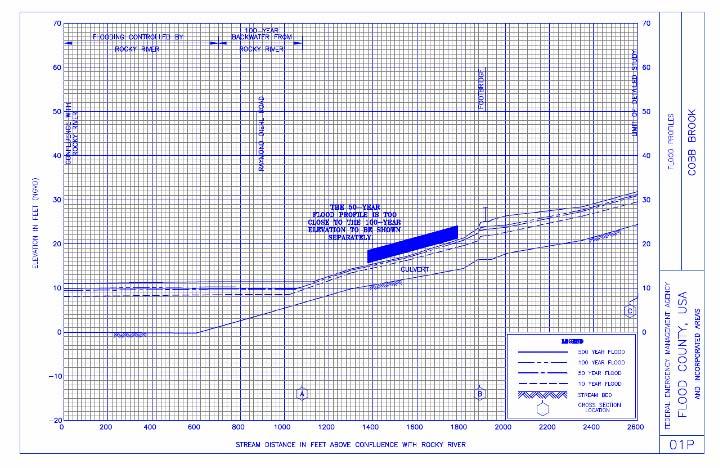
40 Mapping Exercises Example One - FIRMette
41 Mapping Exercises Example One Residential Development A 150 ft by 200 ft lot on the West side of Plaza Drive 125 ft North of the intersection with Glebe Way Is this site Located in a floodplain? Located in the regulatory floodway? What might you tell the developer? What will the borrower be told?

42 Mapping Exercises Locate Property on FIRM A 150 ft by 200 ft lot on the West side of Plaza Drive 125 ft North of the intersection with Glebe Way
43 Mapping Exercises Locate Property on FIRM A 150 ft by 200 ft lot on the West side of Plaza Drive 125 ft North of the intersection with Glebe Way
44 Mapping Exercises Determine Permit Requirements Is this site located in a floodplain? Regulatory floodway? Yes No What might you tell the developer? Any work in Zone AE needs a permit Stay out of the 1% floodplain Need contour information Provide a detailed site plan What might the lender say? Structures in Zone AE to be elevated Need flood insurance!


45 Mapping Exercises Determine BFE using the Flood Profile BFE = 10.5 ft Determine Flow and nearest Landmark
46 Mapping Exercises Determine BFE using Floodway Data Table Regulatory (BFE) Elevation = 10.4 ft

47 Mapping Exercises Example Two - FIRMette
48 Mapping Exercises Example Two Community Development Community development dept. wants to replace the existing footbridge over Cobb Brook Is a permit required for this project? Is an Elevation Certificate required? Should any documentation be submitted prior to issuing the permit? Can the top of the new footbridge be built below the regulatory 1% flood elevation?
49 Mapping Exercises Locate Property on FIRM Community development dept. wants to replace the existing footbridge over Cobb Brook
50 Mapping Exercises Determine Permit Requirements Is a permit required? Yes! Is an Elev. Cert. required? No Should any documentation be submitted prior to issuing the permit? Yes For development in detailed study areas, without a regulatory floodway, proof should be submitted showing the proposed development will not increase existing flood heights by more than one foot (44CFR 60.3(C)(10)).
(10) of the local floodplain ordinance.")
51 Mapping Exercises Determine Permit Requirements (cont.) Can the top of the new footbridge be built below the regulatory 1% flood elevation? Existing footbridge is above the 1% and 0.2 % events. Yes IF they can meet the requirements of Section 60.3(c)(10) of the local floodplain ordinance. This proof must be obtained prior to issuing the permit.
52 Mapping Exercises Example Three - FIRMette
53 Mapping Exercises Example Three DFIRM Development A 100 ft by 100 ft residential lot on the South side of Wesley Street with the front corners being located 650 ft & 750 ft East of the centerline of Rock Hill Road. Is the site located in the 1% floodplain? Is the site located in the regulatory floodway? Is an Elevation Certificate required for this type of development? Will a No-Rise Certificate be required? What is the BFE for this site?
54 Mapping Exercises Locate Property on DFIRM A 100 ft by 100 ft residential lot on the South side of Wesley Street with the front corners being located 650 ft & 750 ft East of the centerline of Rock Hill Road.
55 Mapping Exercises Determine Permit Requirements Is this site located in the 1% floodplain? Yes Regulatory floodway? No Not located in hatched area. Is an Elevation Certificate required for this type of development? Yes Will a No-Rise Certificate be required? No No-Rise Certificates are only required when the development falls within a regulatory floodway.

56 Mapping Exercises Determine BFE using the Flood Profile Backwater Effects from the Big River Determine the Direction of Flow & Nearest Landmark FLOOD COUNTY, USA Use the FIRMette to..
57 Mapping Exercises Determine BFE using the Floodway Data Table What is the BFE for this site? Regulatory (BFE) elevation = ft


58 Mapping Exercises Elevation Certificate John Q. Surveyor John Q. Surveyor If to be used for compliance purposes the finished construction box must be checked and the document must be properly certified.


59 Mapping Exercises Permit vs. Elevation Certificate Compliant: Lowest Floor is > the community elevation requirement
60 Mapping Exercises Example Four - FIRMette

61 Mapping Exercises Example Four Floodway Development A two acre residential lot at the end of Eagle Drive as shown on the FIRMette below. Can this lot even be developed under current NFIP regulations? Developer could not provide a No-Rise for the original location of the house, moved structure out of the floodway, is a No-Rise Certificate still required? Can a permit be issued prior to receiving the No-Rise Certificate?

62 Mapping Exercises Determine Permit Requirements FLOODWAY Can this lot even be developed under current NFIP regulations? Yes The structure is no longer in the regulatory floodway but there is still going to be some utility work & grading activities occurring, is a No-Rise Certificate still needed? Yes Can the permit be issued prior to receiving the No-Rise Certificate? No


63 Mapping Exercises No-Rise Certificate Example This certificate is all that is provided to show No-Rise ; is this acceptable? OK YES! January 4, 2008


64 Mapping Exercises Permit Is the permit acceptable? YES OK

65 Mapping Exercises Elevation Certificate OK Is the Elev. Cert. acceptable for proof of compliance? Verify street address OK Verify BFE information Verify Finished Construction is checked OK Not OK Verify elevation datum OK Verify the Top of Bottom Floor is above the elevation requirement John W. Engineer OK June 4, 2008 Verify document is certified by a Registered Professional

66 Mapping Exercises Elevation Certificate Page Two Is the Elev. Cert. acceptable for proof of compliance? Not OK Finished construction not checked and missing 2 nd certification signature on page 2 OK OK NO Verify comment section is filled out for elevation listed in C2e Verify 2nd page is also certified by a Registered Professional Recommend completing Section G for record keeping purposes only
67 Updating Maps Physical map revision process, such as MapMod Result: New map Letters of Map Change processes Amendment (LOMA) natural change Revision (LOMR) manmade change Result: Part of map changed
68 Letters of Map Amendment LOMA for inadvertent inclusions MT-EZ Form: single residential lot or structure E-LOMA online application engineers, surveyors MT-1 Form: multiple residential lots or structures CLOMA based on proposed situation
69 Letters of Map Revision LOMR-F for structures on fill MT-1 Form LOMR MT-2 Form CLOMR-F and CLOMR based on proposed situation
70 LOMC Process FEMA reviews and issues letter FEMA fees to review applications vary Can be up to $6,000 for LOMRs Online FEMA tutorials:
71 UNIT II Summary Review Where did we confuse you in covering: Types of flood maps Flood insurance studies (FIS) Using maps Working with Approximate A zones Letters of Map Change (LOMC)?
Durham County Preliminary Flood Hazard Data Public Meeting. July 28, 2016
 Durham County Preliminary Flood Hazard Data Public Meeting July 28, 2016 Why Are We Here New flood hazard data has been released as Preliminary for Durham County Statutory Due Process for review/comments
NFIP Mapping Issues. Wendy Lathrop, PLS, CFM. Cadastral Consulting, LLC
 NFIP Mapping Issues Cadastral Consulting, LLC NFIP Basic Objectives: Reduce the exposure to flood damages through the use of minimum standards for the placement and design of structures located in flood
National Flood Insurance Program (NFIP) for Real Estate Professionals
 for Real Estate Professionals") National Flood Insurance Program (NFIP) for Real Estate Professionals 1 Joshua Oyer, CFM Outreach Specialist NFIP State Coordinator s Office at the Texas Water Development Board 2 Outline Introduction
National Flood Insurance Program (NFIP) for Real Estate Professionals 1 Joshua Oyer, CFM Outreach Specialist NFIP State Coordinator s Office at the Texas Water Development Board 2 Outline Introduction
Requirements for Construction on Properties in the Special Flood Hazard Area (SFHA)
") Requirements for Construction on Properties in the Special Flood Hazard Area (SFHA) Rev 010915 The website for the IDNR to request the EFARA (Electronic Floodplain Analysis/Regulatory Assessment is found
Requirements for Construction on Properties in the Special Flood Hazard Area (SFHA) Rev 010915 The website for the IDNR to request the EFARA (Electronic Floodplain Analysis/Regulatory Assessment is found
Enough about me! Topics Covered
 About Me Worked in land surveying since 1997 Employed by the City of Orlando since 2006 City of Orlando City Surveyor since February 2015 Certified Floodplain Manager since 2015 Florida Licensed Surveyor,
MT-1 Basics: A Comprehensive Overview of LOMAs and Discussion of Common Application Setbacks
 MT-1 Basics: A Comprehensive Overview of LOMAs and Discussion of Common Application Setbacks Introduction: Terminology MT-1s vs. MT-2s LOMAs vs. LOMRs What is a LOMC? Letters of Map Change (LOMCs) MT-1s
JAXGIS FEMA Flood Hazard Mapping -- Frequently Asked Questions
 Flood Hazard Zone Designations Summary Zones starting with the letter 'A' (for instance, Zone A, Zone AE, Zone AH, Zone AO) denote a Special Flood Hazard Area, which can also be thought of as the 100-year
THE FEDERAL EMERGENCY MANAGEMENT AGENCY. Letters of Map Change Kristen Martinenza, P.E., CFM FEMA Region IV
 THE FEDERAL EMERGENCY MANAGEMENT AGENCY Letters of Map Change Presented by: Kristen Martinenza, P.E., CFM FEMA Region IV 1 NATIONAL FLOOD INSURANCE ACT OF 1968 At the start of the program, there was not
MANAGING FLOODS OF THE FUTURE: CONCEPTS, TOOLS & SUCCESS STORIES Iowa Post-Disaster Workshops November 12 & 13, 2008 Cedar Falls & Iowa City, Iowa
 MANAGING FLOODS OF THE FUTURE: CONCEPTS, TOOLS & SUCCESS STORIES Iowa Post-Disaster Workshops November 12 & 13, 2008 Cedar Falls & Iowa City, Iowa Sam Riley Medlock, CFM, JD ASFPM Policy & Partnerships
Kevin Wagner Maryland Department of the Environment
 Kevin Wagner Maryland Department of the Environment Topics Overview of the National Flood Insurance Program (NFIP) Mapping Regulations Insurance Mitigation Community Rating System (CRS) Questions Know
NFIP Overview Elevation Certificate Flood Insurance Rate Maps. By: Maureen O Shea, AICP, CFM State NFIP Coordinator
 NFIP Overview Elevation Certificate Flood Insurance Rate Maps By: Maureen O Shea, AICP, CFM State NFIP Coordinator Example of a flood failure Example of a flood failure Purposes of the NFIP Identify &
History of Floodplain Management in Ascension Parish
 History of Floodplain Management in Ascension Parish presented by: Kara Moree Floodplain Coordinator February 6, 2012 Floodplain 101 Floodplain 101 Base or 1% Flood: A flood having a 1% chance of being
PRODUCER ANNUITY SUITABILITY TRAINING REQUIREMENTS BY STATE As of September 11, 2017
 PRODUCER ANNUITY SUITABILITY TRAINING REQUIREMENTS BY STATE As of September 11, 2017 This document provides a summary of the annuity training requirements that agents are required to complete for each
Floodplain Management 101. Mississippi Emergency Management Agency Floodplain Management Bureau
 Floodplain Management 101 Mississippi Emergency Management Agency Floodplain Management Bureau Stafford Act The Stafford Disaster Relief and Emergency Assistance Act (Stafford Act) (Public Law 100-707)
What Was Updated in 2004 in Hennepin Countywide Maps?
 What Was Updated in 2004 in Hennepin Countywide Maps? Combined the city and township maps into one countywide index Done by USACE Mainly digital capture of old floodplain boundaries; some spots with shifts
INSTRUCTIONS FOR COMPLETING THE APPLICATION FORMS FOR CONDITIONAL LETTERS OF MAP REVISION AND LETTERS OF MAP REVISION
 INSTRUCTIONS FOR COMPLETING THE APPLICATION FORMS FOR CONDITIONAL LETTERS OF MAP REVISION AND LETTERS OF MAP REVISION GENERAL In 1968, the U.S. Congress passed the National Flood Insurance Act, which created
Pinellas County Flood Map Information Service & Real Estate Disclosure Program Training January 26, 2017 COMMON FLOODPLAIN ACRONYMS
 FEMA ASFPM BFE CAV Pinellas County Flood Map Information Service & Real Estate Disclosure Program Training COMMON FLOODPLAIN ACRONYMS Federal Emergency Management Agency Association of State Floodplain
TCJA and the States Responding to SALT Limits
 TCJA and the States Responding to SALT Limits Kim S. Rueben Tuesday, January 29, 2019 1 What does this mean for Individuals under TCJA About two-thirds of taxpayers will receive a tax cut with the largest
FLOODPLAIN FAQ s. Last Update: June 2017
 FLOODPLAIN FAQ s Last Update: June 2017 What does FEMA stand for? Federal Emergency Management Agency - the operation of FEMA is to lead America to prepare for, prevent, respond to, and recover from disasters.
Herkimer County, New York Flood Hazard Mapping Status Report for Property Owners
 Herkimer County, New York Flood Hazard Mapping Status Report for Property Owners Herkimer County, New York Flood Hazard Mapping Status Report for Property Owners FLOOD INSURANCE Who Should Purchase Flood
Federal Emergency Management Agency
 Page 1 of 4 Issue Date: September 7, 2012 Effective Date: January 22, 2013 DETERMINATION DOCUMENT COMMUNITY COMMUNITY AND REVISION INFORMATION City of Lubbock Lubbock County Texas PROJECT DESCRIPTION CHANNELIZATION
Floodplain Management Annual Conference Atlanta, Georgia April 2017
 Floodplain Management 2017 Annual Conference Atlanta, Georgia April 2017 Floodplain Mapping and Flood Zones Zone Deisgnations: Zone A: No base flood elevations have been determined it is an approximated
Federal Emergency Management Agency
 Page 1 of 5 Issue Date: July 27, 2012 Effective Date: December 10, 2012 Case No.: 11-06-4512P Follows Conditional Case No.: 06-06-B789R LOMR-APP Federal Emergency Management Agency Washington, D.C. 20472
Comparative Revenues and Revenue Forecasts Prepared By: Bureau of Legislative Research Fiscal Services Division State of Arkansas
 Comparative Revenues and Revenue Forecasts 2010-2014 Prepared By: Bureau of Legislative Research Fiscal Services Division State of Arkansas Comparative Revenues and Revenue Forecasts This data shows tax
SECTION 9: MAPS AND DATA
 SECTION 9: MAPS AND DATA Contents 9.1. NFIP Maps and Data... 9-2 9.1.1. Adopting and enforcing NFIP floodplain maps and data... 9-2 9.1.2. Adopting and enforcing more restrictive data... 9-2 9.1.3. Annexations...
10526 Bermuda Isle Dr. Tampa, FL 33647
 Flood Analysis Memo Property Address 10526 Bermuda Isle Dr. In Partnership with: ** This property is NOT within a high-risk flood zone ** 10526 Bermuda Isle Dr. BFE = 35 ft This property is located in
Federal Emergency Management Agency
 Page 1 of 6 Issue Date: September 27, 2010 Effective Date: February 14, 2011 Follows Conditional Case No.: 08-08-0873R DETERMINATION DOCUMENT COMMUNITY AND REVISION INFORMATION PROJECT DESCRIPTION BASIS
ASFPM Partnerships for Statewide Mitigation Actions. Alicia Williams GIS and HMP Section Manager, Amec Foster Wheeler June 2016
 ASFPM Partnerships for Statewide Mitigation Actions Alicia Williams GIS and HMP Section Manager, Amec Foster Wheeler June 2016 Summary The Concept Leveraging Existing Data and Partnerships to reduce risk
Older consumers and student loan debt by state
 August 2017 Older consumers and student loan debt by state New data on the burden of student loan debt on older consumers In January, the Bureau published a snapshot of older consumers and student loan
Floodplain Development Permit Application
 Floodplain Development Permit Application **All construction will also require a building permit** This is an application packet for a Floodplain Development Permit. Certain sections are to be completed
Table 1: Federal, State and Local Government Rules applicable to LOMRs/CLOMRS submittal
 MnDNR LOMC Guide This document has been prepared by the Minnesota Department of Natural Resources floodplain staff and is intended to provide assistance with LOMR/CLOMR submittals. This information is
Skagit County Flood Insurance Study Update. Ryan Ike, CFM FEMA Region 10
 Skagit County Flood Insurance Study Update Ryan Ike, CFM FEMA Region 10 Skagit County Flood Insurance Study Process Overview Process, Schedule, & Deliverables Base Flood Elevations, Modeling, & Levees
Preliminary DFIRM Community Coordination (PDCC) Meeting Gilchrist & Levy Counties, FL. April 30, 2015
 Meeting Gilchrist & Levy Counties, FL. April 30, 2015") Preliminary DFIRM Community Coordination (PDCC) Meeting Gilchrist & Levy Counties, FL April 30, 2015 Agenda 1. Introductions 2. Study Process and Timeline 3. Overview of Preliminary Products 4. Overview
Preliminary DFIRM Community Coordination (PDCC) Meeting Gilchrist & Levy Counties, FL April 30, 2015 Agenda 1. Introductions 2. Study Process and Timeline 3. Overview of Preliminary Products 4. Overview
Cost and Coverage Implications of the ACA Medicaid Expansion: National and State by State Analysis
 Cost and Coverage Implications of the ACA Medicaid Expansion: National and State by State Analysis Report Authors: John Holahan, Matthew Buettgens, Caitlin Carroll, and Stan Dorn Urban Institute November
2016 Workers compensation premium index rates
 2016 Workers compensation premium index rates NH WA OR NV CA AK ID AZ UT MT WY CO NM MI VT ND MN SD WI NY NE IA PA IL IN OH WV VA KS MO KY NC TN OK AR SC MS AL GA TX LA FL ME MA RI CT NJ DE MD DC = Under
National Flood Insurance Program
 National Flood Insurance Program FEMA ELEVATION CERTIFICATES PA Surveyor Training Presented by Thomas F. Smith, PE, PLS January 22, 2018 1 FEMA Region III Mitigation Division Floodplain Management & Insurance
10526 Bermuda Isle Dr. Tampa, FL 33647
 Flood Analysis Memo Property Address In Partnership with: ** This property is NOT within a high-risk flood zone ** This property is located in a FEMA low-risk zone designated as Zone X - an area of minimal
Federal Emergency Management Agency
 Page 1 of 4 Issue Date: August 1, 2012 Effective Date: December 13, 2012 Case No.: 12-06-0595P LOMR-APP Washington, D.C. 20472 LETTER OF MAP REVISION DETERMINATION DOCUMENT COMMUNITY AND REVISION INFORMATION
INSTRUCTIONS FOR COMPLETING THE APPLICATION FORMS FOR CONDITIONAL LETTERS OF MAP REVISION AND LETTERS OF MAP REVISION
 INSTRUCTIONS FOR COMPLETING THE APPLICATION FORMS FOR CONDITIONAL LETTERS OF MAP REVISION AND LETTERS OF MAP REVISION GENERAL In 1968, the U.S. Congress passed the National Flood Insurance Act, which created
Federal Emergency Management Agency
 Page 1 of 5 Issue Date: October 28, 2009 Follows Conditional Case No.: 08-08-0612R DETERMINATION DOCUMENT COMMUNITY AND REVISION INFORMATION PROJECT DESCRIPTION BASIS OF REQUEST COMMUNITY Lincoln County
Appendix D - Floodplain Documents
 City of Aspen Urban Runoff Management Plan Appendix D - Floodplain Documents 1. Floodplain Development Permit 2. Elevation Certificate and Instructions 3. Floodproofing Certificate for Non-Residential
LOCAL OFFICIALS MEETING Lake Wausau Physical Map Revision MARATHON COUNTY, WISCONSIN FEBRUARY 9, 2017
 LOCAL OFFICIALS MEETING Lake Wausau Physical Map Revision MARATHON COUNTY, WISCONSIN FEBRUARY 9, 2017 Welcome & Introduction Michelle Staff Floodplain Management Policy Coordinator, WDNR Michelle.Staff@Wisconsin.gov
Updates to Maine Coastal Flood Insurance Rate Maps (FIRM s): What a Local Official Should Know. Presented by: Steve Johnson, P.E.
: What a Local Official Should Know. Presented by: Steve Johnson, P.E.") Updates to Maine Coastal Flood Insurance Rate Maps (FIRM s): What a Local Official Should Know Presented by: Steve Johnson, P.E. Town Engineer October 4, 2018 Introduction Federal Emergency Management
Updates to Maine Coastal Flood Insurance Rate Maps (FIRM s): What a Local Official Should Know Presented by: Steve Johnson, P.E. Town Engineer October 4, 2018 Introduction Federal Emergency Management
THE $64,000 FLOOD INSURANCE BILL
 THE $64,000 FLOOD INSURANCE BILL GEORGIA ASSOCIATION OF FLOODPLAIN MANAGERS 9 TH ANNUAL TECHNICAL CONFERENCE Patrick Gervais, PE, CFM A CASE STUDY IN FLOOD INSURANCE This is a true story that happened
Door County Floodplain Program Informational Meeting
 Door County Floodplain Program Informational Meeting Door County Land Use Services Department Wisconsin Department of Natural Resources January 15, 2018 Floodplain = Land affected by flood event with a
Property Tax Relief in New England
 Property Tax Relief in New England January 23, 2015 Adam H. Langley Senior Research Analyst Lincoln Institute of Land Policy www.lincolninst.edu Property Tax as a % of Personal Income OK AL IN UT SD MS
210 W Canal Dr Palm Harbor, FL 34684
 Flood Analysis Memo Property Address In Partnership with: ** This property is within a high risk flood zone ** BFE = 6 ft This property is located in the FEMA designated high-risk zone, Zone AE - an area
CRISP COUNTY, GEORGIA AND INCORPORATED AREAS
 CRISP COUNTY, GEORGIA AND INCORPORATED AREAS Community Name Community Number ARABI, CITY OF 130514 CORDELE, CITY OF 130214 CRISP COUNTY (UNINCORPORATED AREAS) 130504 Crisp County EFFECTIVE: SEPTEMBER 25,
Federal Emergency Management Agency
 Page 1 of 5 Issue Date: October 16, 2014 Effective Date: March 2, 2015 Case No.: 14-09-2279P LOMR-APP Federal Emergency Management Agency Washington, D.C. 20472 LETTER OF MAP REVISION DETERMINATION DOCUMENT
Revisions to National Flood Insurance Program Maps
 MT-1 Revisions to National Flood Insurance Program Maps Application Forms and Instructions for Conditional and Final Letters of Map Amendment and Letters of Map Revision Based on Fill FEMA Form 81-87 Series
SUPERHERO!!! Elevation Certificate. You are about to go from SURVEYOR 2/18/2019
 Karol L. Grove Licensed Professional Surveyor Certified Floodplain Manager Elevation Certificate No longer the Animal it used to be When are they needed??? You are about to go from SURVEYOR to SUPERHERO!!!
Now forget it all for the next 90 minutes.
 Karol L. Grove, PS Get ready to think outside of the box. Get ready to think about surveying, flood zones and flood insurance in a whole new light.. Think about everything you think you know about Elevation
F E M A Mapping Changes. FEMA Mapping Changes. National Flood Insurance Program
 FEMA Mapping Changes National Flood Insurance Program 1 Welcome to FEMA Mapping Changes! We will get started in a few minutes. Meanwhile, let s perform a warm up exercise. 2 1 Training Agenda Section 1-
IRA Distribution Form
 Use this form to request distributions from your IRA account and to close an IRA. Instructions 1. Complete the form and include any necessary supporting documents. 2. Sign and send us the completed form.
Florida 1/1/2016 Workers Compensation Rate Filing
 Florida 1/1/2016 Workers Compensation Rate Filing Kirt Dooley, FCAS, MAAA October 21, 2015 1 $ Billions 4.0 3.5 3.0 2.5 2.0 1.5 1.0 0.5 0.0 Florida s Workers Compensation Premium Volume 2.368 0.765 0.034
Taxing Investment Income in the States New Hampshire Fiscal Policy Institute 2 nd Annual Budget and Policy Conference Concord, NH January 23, 2015
 Taxing Investment Income in the States New Hampshire Fiscal Policy Institute 2 nd Annual Budget and Policy Conference Concord, NH January 23, 2015 Norton Francis State and Local Finance Initiative Urban-Brookings
Mistakes on Elevation Certificates
 Mistakes on Elevation Certificates What is the Base Flood Elevation (BFE) & how do you determine it? FIRM Map Panel? Flood Insurance Study? o Profile Sheet o Floodway Data Chart o Stillwater Chart Community
Just The Facts: On The Ground SIF Utilization
 Just The Facts: On The Ground SIF Utilization The Access 4 Learning Community (A4L), previously the SIF Association, has changed its brand name due to the fact that the majority of its 3,000 members represent
Unemployment Insurance Benefit Adequacy: How many? How much? How Long?
 Unemployment Insurance Benefit Adequacy: How many? How much? How Long? Joel Sacks, Deputy Commissioner Washington State Employment Security Department March 1, 2012 1 Outline How many get unemployment
Dealing With Unnumbered A Zones in Maine Floodplain Management
 Dealing With Unnumbered A Zones in Maine Floodplain Management The following is a list of acceptable methods that the State Floodplain Management Coordinator and the Federal Emergency Management Agency
The Lincoln National Life Insurance Company Term Portfolio
 The Lincoln National Life Insurance Company Term Portfolio State Availability as of 7/16/2018 PRODUCTS AL AK AZ AR CA CO CT DE DC FL GA GU HI ID IL IN IA KS KY LA ME MP MD MA MI MN MS MO MT NE NV NH NJ
Introduction to the National Flood Insurance Program: A Guide for Coastal Property Owners MAINE BEACHES CONFERENCE 2017
 Introduction to the National Flood Insurance Program: A Guide for Coastal Property Owners MAINE BEACHES CONFERENCE 2017 SUE BAKER, CFM STATE NFIP COORDINATOR MAINE DEPT OF AGRICULTURE, CONSERVATION & FORESTRY
Taylor County, Florida Community Coordination and Outreach (CCO) Meeting
 Meeting") Taylor County, Florida Community Coordination and Outreach (CCO) Meeting Suwannee River Water Management District April 26, 2017 11:00AM to 12:00PM Taylor County Administration Building, 201 E. Green Street,
Taylor County, Florida Community Coordination and Outreach (CCO) Meeting Suwannee River Water Management District April 26, 2017 11:00AM to 12:00PM Taylor County Administration Building, 201 E. Green Street,
St. Johns County, Florida Consultation Coordination Officer (CCO) Meeting. August 31, 2016 St. Augustine, Florida
 Meeting. August 31, 2016 St. Augustine, Florida") St. Johns County, Florida Consultation Coordination Officer (CCO) Meeting August 31, 2016 St. Augustine, Florida Agenda Introductions Coastal Study Update Study Process and Timeline Flood Insurance Implications
St. Johns County, Florida Consultation Coordination Officer (CCO) Meeting August 31, 2016 St. Augustine, Florida Agenda Introductions Coastal Study Update Study Process and Timeline Flood Insurance Implications
Why do we care about floodplains?
 NFIP 101 Outline What is the NFIP? What are its goals? What is a flood? A floodplain? Maps, FIRMs, and FISs NFIP Requirements Local Flood Ordinances & Permitting Tips, Tricks, & Tools Mitigation & Other
ehealth, Inc Fall Cost Report for Individual and Family Policyholders
 ehealth, Inc. 2010 Fall Cost Report for and Family Policyholders Table of Contents Page Methodology.................................................................. 2 ehealth, Inc. 2010 Fall Cost Report
The Entry, Performance, and Viability of De Novo Banks
 The Entry, Performance, and Viability of De Novo Banks Yan Lee and Chiwon Yom* FEDERAL DEPOSIT INSURANCE CORPORATION *The views expressed here are solely of the authors and do not necessarily reflect the
Federal Emergency Management Agency
 Page 1 of 5 Issue Date: April 2, 2015 DETERMINATION DOCUMENT COMMUNITY AND REVISION INFORMATION PROJECT DESCRIPTION BASIS OF REQUEST Ventura County California NO PROJECT UPDATE COMMUNITY (Unincorporated
State Trust Fund Solvency
 Unemployment Insurance State Trust Fund Solvency National Employment Law Project Conference - Washington DC December 7, 2009 Robert Pavosevich pavosevich.robert@dol.gov Unemployment Insurance Program
RLI TRANSPORTATION A Division of RLI Insurance Company 2970 Clairmont Road, Suite 1000 Atlanta, GA Phone: Fax:
 RLI TRANSPORTATION A Division of RLI Insurance Company 2970 Clairmont Road, Suite 1000 Atlanta, GA 30329 Phone: 404-315-9515 Fax: 404-315-6558 AGENCY/BROKER PROFILE Please type your answers. Use a separate
Federal Emergency Management Agency
 Page 1 of 4 Issue Date: April 26, 2013 DETERMINATION DOCUMENT COMMUNITY AND REVISION INFORMATION PROJECT DESCRIPTION BASIS OF REQUEST City of Coppell Dallas County Texas FILL HYDRAULIC ANALYSIS NEW TOPOGRAPHIC
Federal Emergency Management Agency
 Page 1 of 4 Issue Date: November 16 2016 Effective Date: March 31 2017 Case No: 16-06-2056P LOMR-APP Follows Conditional Case No: 10-06-3320R Federal Emergency Management Agency Washington DC 20472 LETTER
Tax Freedom Day 2018 is April 19th
 Apr. 2018 Tax Freedom Day 2018 is April 19th Erica York Analyst Key Findings Tax Freedom Day is a significant date for taxpayers and lawmakers because it represents how long Americans as a whole have to
State Treatment of Social Security Treatment of Pension Income Other Income Tax Breaks Property Tax Breaks
 State-By-State Tax Breaks for Seniors, 2016 State Treatment of Social Security Treatment of Pension Income Other Income Tax Breaks Property Tax Breaks AL Payments from defined benefit private plans are
Role of the Local Floodplain Administrator
 2/22/2016 Role of the Local Floodplain Administrator Marsha Hilmes-Robinson Floodplain Administrator City of Fort Collins, Colorado mhilmesrobinson@fcgov.com 1 Partnership Engineer/Architect/ Contractor
State of the Automotive Finance Market
 State of the Automotive Finance Market A look at loans and leases in Q4 2017 Presented by: Melinda Zabritski Sr. Director, Financial Solutions www.experian.com/automotive 2018 Experian Information Solutions,
Age of Insured Discount
 A discount may apply based on the age of the insured. The age of each insured shall be calculated as the policyholder s age as of the last day of the calendar year. The age of the named insured in the
2018 National Electric Rate Study
 2018 National Electric Rate Study Ranking of Typical Residential, Commercial and Industrial Electric Bills LES Administrative Board June 15, 2018 Emily N. Koenig Director of Finance & Rates 1 Why is the
Federal Emergency Management Agency
 Page 1 of 4 Issue Date: October 2, 2017 Effective Date: October 2, 2017 Case No.: 17-09-2731P LOMR-APP Federal Emergency Management Agency Washington, D.C. 20472 LETTER OF MAP REVISION DETERMINATION DOCUMENT
States and Medicaid Provider Taxes or Fees
 March 2016 Fact Sheet States and Medicaid Provider Taxes or Fees Medicaid is jointly financed by states and the federal government. Provider taxes are an integral source of Medicaid financing governed
Federal Tax Reform Impact on 2019 Legislative Sessions: GILTI
 Federal Tax Reform Impact on 2019 Legislative Sessions: GILTI Executive Committee Task Force on State and Local Taxation Scottsdale, Arizona November 17, 2018 Karl Frieden, COST Deborah Bierbaum, AT&T
NFIP Program Basics. KAMM Regional Training
 NFIP Program Basics KAMM Regional Training Floodplain 101 Homeowners insurance does not cover flood damage Approximately 25,000 flood insurance policies in KY According to BW12 analysis, approximately
Tax Breaks for Elderly Taxpayers in the States in 2016
 AL Payments from defined benefit private plans are exempt; most public systems are exempt; military and US Civil service are exempt Special Homestead ion for 65+ +25.2% +2.4% AK No PIT Homestead ion for
The Acquisition of Regions Insurance Group. April 6, 2018
 The Acquisition of Regions Insurance Group April 6, 2018 Forward-Looking Statements This presentation contains "forward-looking statements" within the meaning of the Private Securities Litigation Reform
Cameron County, TX. Consultation Coordination Officer (CCO) Meeting. Please sign in (sheet at front of the room) Meeting will begin at 9:00
 Meeting. Please sign in (sheet at front of the room) Meeting will begin at 9:00") Cameron County, TX Consultation Coordination Officer (CCO) Meeting Please sign in (sheet at front of the room) Meeting will begin at 9:00 July 29, 2015 Lisa Jennings FEMA Region 6 Roles & Responsibilities
Cameron County, TX Consultation Coordination Officer (CCO) Meeting Please sign in (sheet at front of the room) Meeting will begin at 9:00 July 29, 2015 Lisa Jennings FEMA Region 6 Roles & Responsibilities
COMMUNITY CREDIT CHART BOOK
 2016 COMMUNITY CREDIT CHART BOOK FEDERAL RESERVE B ANK of NEW YORK Editors Kausar Hamdani, Ph.D. SVP and Senior Advisor Claire Kramer Mills, Ph.D. AVP and Community Affairs Officer Data Support Jessica
Oregon: Where Taxes Are Low, Fees Are High and Revenue Is Slightly Below Average
 Issue Brief March 6, 2012 Oregon: Where Taxes Are Low, Fees Are High and Revenue Is Slightly Below Average The money we pay in fees and taxes helps create jobs, build a strong economy, and preserve Oregon
Gun Club General Liability Application for Coverage
 Club Name Club Address City State Telephone Contact Person ZIP Email Fax For Internal Use Only Account #: App Date: Target $: Indication? Yes No Need by: Rep: General Information Total Number of Locations:
IRA Distribution Request Instructions and Form
 IRA Distribution Request Instructions and Form 877.836.3949 203.388.2714 www.vfmarkets.com Send to: Email: US Mail: (Please submit using one method) clientservices@vfmarkets.com 120 Long Ridge Rd., 3 North
Flood Map Revisions. Town of Nags Head Public Information and Input Session. December 14, 2016, 6 pm
 Flood Map Revisions Town of Nags Head Public Information and Input Session December 14, 2016, 6 pm Flood Map Revisions New preliminary flood maps released for Dare County June 30, 2016 www.nagsheadnc.gov/floodmaps
Gail Moldovan-Trujillo, ACSR,CPIW Hagan Hamilton Insurance 2012 NFIP Agency of the year Flood Insurance Specialist & Consultant
 Gail Moldovan-Trujillo, ACSR,CPIW Hagan Hamilton Insurance 2012 NFIP Agency of the year Flood Insurance Specialist & Consultant Flood Insurance regulations continue to change at a very rapid pace, therefore
North Carolina Department of Public Safety Emergency Management Risk Management
 North Carolina Department of Public Safety Emergency Management Risk Management Roy Cooper, Governor Erik A. Hooks, Secretary Michael A. Sprayberry, Director INSTRUCTIONS FOR COMPLETING THE NORTH CAROLINA
Federal Emergency Management Agency
 Page 1 of 5 Issue Date: June 21, 2013 Follows Conditional Case No.: 04-06-A148R DETERMINATION DOCUMENT COMMUNITY COMMUNITY AND REVISION INFORMATION City of Irving Dallas County Texas FILL PROJECT DESCRIPTION
Nassau County, Florida Consultation Coordination Officer (CCO) Meeting. February 24, 2016 Fernandina Beach, Florida
 Meeting. February 24, 2016 Fernandina Beach, Florida") Nassau County, Florida Consultation Coordination Officer (CCO) Meeting February 24, 2016 Fernandina Beach, Florida Agenda Introductions Coastal Study Update Study Process and Timeline Flood Insurance Implications
Nassau County, Florida Consultation Coordination Officer (CCO) Meeting February 24, 2016 Fernandina Beach, Florida Agenda Introductions Coastal Study Update Study Process and Timeline Flood Insurance Implications
Local Anesthesia Administration by Dental Hygienists State Chart
 Education or AK 1981 General Both Specific Yes WREB 16 hrs didactic; 6 hrs ; 8 hrs lab AZ 1976 General Both Accredited Yes WREB 36 hrs; 9 types of AR 1995 Direct Both Accredited/ Board Approved No 16 hrs
Agenda. Introduction. Introduction -Map Study Lifecycle. Insurance Benefits of New Map
 Agenda Introduction Effects of Map Changes on Flood Insurance Lower risk to higher risk ( Grandfathering ) Higher risk to lower risk ( Conversion ) No Change Vertical Datum change Summary Levees Levees
IMPORTANT TAX INFORMATION
 IMPORTANT TAX INFORMATION To set up and maintain your account with WestconGroup, we require you to provide us valid Resale Certificates for all states that you are located in, as well as for any other
Abington Township Public Meeting
 Abington Township Public Meeting Flood Insurance Rate Map Update March 23, 2016 1 Meeting Agenda and Format Provide residents/property owners of Abington Township with information about the map update,
Federal Emergency Management Agency
 Page 1 of 6 Issue Date: October 24, 2012 Effective Date: March 7, 2013 Case No.: LOMR-APP DETERMINATION DOCUMENT COMMUNITY AND REVISION INFORMATION PROJECT DESCRIPTION BASIS OF REQUEST City of Lubbock
Best Practices. for Incorporating Building Science Guidance into Community Risk MAP Implementation November 2012
 Best Practices for Incorporating Building Science Guidance into Community Risk MAP Implementation November 2012 Federal Emergency Management Agency Department of Homeland Security 500 C Street, SW Washington,