THE FEDERAL EMERGENCY MANAGEMENT AGENCY. Letters of Map Change Kristen Martinenza, P.E., CFM FEMA Region IV
|
|
|
- Dominic Hart
- 5 years ago
- Views:
Transcription
1 THE FEDERAL EMERGENCY MANAGEMENT AGENCY Letters of Map Change Presented by: Kristen Martinenza, P.E., CFM FEMA Region IV 1
2 NATIONAL FLOOD INSURANCE ACT OF 1968 At the start of the program, there was not enough funding to do all mapping with Detailed methods, thus there were two types of analysis done. Detail analysis (developed & developing areas) Approximate Analysis (undeveloped areas) 2
3 BASE MAPS Best topographic maps available Usually U.S.G.S. Quad Sheets Flood data on maps only as good as base maps The greater the level of detail on the topo map, the more accurate the BFE s 3


4 Where do you draw the BFE line for 15 feet?
5 Letter of Map Changes Provide an administrative procedure where by FEMA will review information submitted by an owner of property who believes that his or her property has been inadvertently included in a designated Special Flood Hazard Area.(SFHA) LOMA s processed under Part 70 of the NFIP regulations LOMR-F s processed under Part 65.5 of the NFIP regulations 5
6 LOMA Letter of Map Amendment A letter from FEMA stating that an existing structure or parcel of land that has not been elevated by fill would not be inundated by the 100- year flood 6
7 LOMR-F Letter of Map Revision (Based on Fill) A letter from FEMA stating that an existing structure or parcel of land that has been elevated by fill would not be inundated by the 100-year flood 7
8 Key Terms (LOMAs) Lowest Adjacent Grade (LAG): The elevation of the lowest ground touching the structure s foundation Deck: Required for LOMA, attached structurally/physically to structure Base Flood Elevation (BFE): The elevation of the flood having a one-percent chance of being equaled or exceeded in any given year 8
9 LOMA BFE 9 Laura Algeo 9
10 LOMR-F BFE 10 Laura Algeo 10
11 LOMA LOMR-F BFE 11 Laura Algeo 11
12 Letters of Map Amendment LOMA s 12
13 LOMAs History Originally created to address blocked-out SFHA boundaries and curvilinearized areas using USGS topo maps Designed to provide official statement to lenders about requirement for flood insurance Some emergency maps showed entire community as SFHA Required when NFIP changed from voluntary to mandatory purchase in 1973 Initially applied only to existing structures 13
 Flood Elevation")
14 Letter of Map Amendment: Natural Ground Part 70 of the NFIP Regulations Requires that the Lowest Ground Touching the Structure be Equal to or Higher than the Base (1% Annual Chance) Flood Elevation (BFE) 14
15 Cross Sectional View of a LOMA Request 15
16 HOW TO SUBMIT FOR A LOMA OR LOMR-F MT-EZ Form Can be used for single-lot/structure requests Cannot be used for Multiple-lot/structure requests Requests involving proposed structures or fill Requests involving changes to the base flood elevation or floodways 16 16
17 HOW TO SUBMIT FOR A LOMA OR LOMR-F MT-1 Forms Package Can be used for Single- or multiple-lot/structure requests Requests involving proposed structures or fill Cannot be used for requests involving changes to the base flood elevation 17
18 LOMA & LOMR-F MT-1 Forms MT-1 Form 1: Property Information Form MT-1 Form 2: Elevation Form MT-1 Form 3: Community Acknowledgment Form Payment Information Form 18
19 LOMA & LOMR-F MT-1 Forms LOMC Clearinghouse 847 South Pickett Street Alexandria, VA Attn: LOMC Manager Telephone Number: FEMA-MAP Download MT-1 form: 19
20 Data Requirements (LOMAs cont.) Copy of the recorded Deed or Plat Map - Must have the recorders stamp, seal & signature Copyof a certified site survey showing the property and the location of the existing structure Copy of the NFIP Map indicating the subject property location Must be certified by a R.L.S. or P.E., or additional mapping such as plat or tax assessor s map must be provided to verify the accuracy of the location. 20
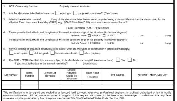
21 Data Requirements (LOMAs cont.) Completed Elevation Information Form or Elevation Certificate indicating the Lowest Adjacent Grade to the structure including any attached decks or the Lowest Property Elevation (certified by an R.L.S. or P.E) Note: In some cases certified topographic mapping will suffice Completed Property Information Form or MT-1 Form Completed by the requester 21
22 Example of LOMA Request ZONE C ZONE B 513 ZONE A Laura Algeo X RM 2
23 Copy of Recorded Deed 23 Laura Algeo 23
24 Tax Assessor s Map 24 Laura Algeo 24
25 Certified Site Plan/Boundary Survey 25 Laura Algeo

26 FIRM With Property Accurately Plotted 26 Laura Algeo 26
27 Effective FIS 27 Laura Algeo 27

28 FIS Flood Profile 28 Laura Algeo 28

29 Signed and Dated Property Information Form 29 Laura Algeo 29
30 The Elevation Certificate Administrative tool of the NFIP Policy rating Support of map revisions and amendments Certify building elevations Community compliance 30

31 Certified Elevation Certificate 31
32 Review by the Director (LOMAs cont.) FEMA is required to notify the applicant in writing of the determination within 60 days from the date of receipt of all of the applicants scientific or technical information. 32
33 33 Laura Algeo

34 34 Laura Algeo
35 35 Laura Algeo
36 Distribution of the LOMA Applicant Community Map Repository (with instructions that it should be attached to the NFIP map to which it is amending) State map repository Community or governmental unit that requests a LOMA FEMA s community files 36
37 Required Fees Requests for Single- Lot, Single-Structure Map Change Single-Lot or Single- Structure LOMA Single-Lot/Single- Structure CLOMA and CLOMR-F Multiple-Lot/Multiple- Structure LOMA Multiple-Lot/Multiple- Structure CLOMA Paper Form Fee Online LOMC Fee Free Free $600 $500 Free Free $800 $700 37
38 Premium Refund (LOMAs cont.) Section 62.5 A Standard Flood Insurance Policy-holder whose property has become the subject of a LOMA under this part may cancel the policy within the current policy year and receive a premium refund under the conditions set forth in this section. 38
39 Letters of Map Revision based on Fill LOMR-F s 39
40 Letters of Map Revision Based on Fill (LOMR-Fs) Revisions to Special Flood Hazard Areas with no change in Base Flood Elevations in areas of special flood hazard (except V Zones and Floodways) it may be feasible to elevate areas (structures or parcels of land) with fill above the BFE Processed Under Section 65.5 of the NFIP Regulations 40
41 Definitions of Key Terms (LOMR-Fs) Fill: Any alteration of topography since the effective date of the first NFIP map showing the property within the SFHA Basement: Any area of a building having its floor subgrade (below ground level) on all sides 41
42 Data Requirements (LOMR-Fs cont.) All same as LOMA and: Community Acknowledgement of Request involving Fill Topographic map indicating present ground elevations and fill. FEEs 42


43 MT1 Form 1: Signed and Dated Property Information Form 43 Laura Algeo 43

44 MT1 Form 2: Elevation Information Form 44


45 MT1 Form 3: Community Acknowledgement of Requests Involving Fill 45


46 Cross-Sectional View of a LOMR-F Request 46
47 Required Fees Requests for Single-Lot, Single- Structure Map Change Single-Lot/Single-Structure CLOMA and CLOMR-F Single-Lot/Single-Structure LOMR-F Single-Lot/Single-Structure LOMR- F Based on As-Built Information (CLOMR-F previously issued Multiple-Lot/Multiple-Structure CLOMR-F and LOMR-F Multiple-Lot/Multiple-Structure LOMR-F Based on As-Built Information (CLOMR-F previously issued by FEMA) Paper Form Fee Online LOMC Fee $600 $500 $525 $425 $425 $325 $900 $800 $800 $700 59
48 Common Problems With LOMA s & LOMR-F s 60
49 LOMA-LOMR-F Common Problems Forms not submitted Forms not completed Confusion about definitions Lowest Adjacent Grade Lowest Floor Elevation Lowest Lot Elevation 61
50 LOMA-LOMR-F Common Problems Only Lowest Floor Elevation submitted Grading complete, but house not built (cannot remove house) Recordation data missing from deed or plat 62
51 LOMA-LOMR-F Common Problems Plat or tax map insufficient to locate property on FIRM Plat not certified 63
52 E-LOMA, online LOMC and NFHL Anyone heard of these? Anyone here registered? Hazards.fema.gov 64
53 eloma Determination Tool A Faster and Greener Way to Obtain LOMA Determinations Kristen Martinenza, P.E., CFM FEMA, Region IV Mitigation Division
 with a")
54 What is eloma and who can use it? eloma is a MIP application designed to provide licensed land surveyors and professional engineers (Licensed Professionals or LPs) with a web-based system to submit and print simple LOMA requests l/wps/portal 66

55 What are the benefits of eloma? The eloma tool is designed to allow users to receive a determination from FEMA in minutes. The user can print a copy almost instantly. Electronic transfer of data Less mailing and printing uses less paper 67
56 When can t eloma be used? Current Limitations Existing single residential structures or legally recorded parcels of land not involving the placement of fill Detailed study areas (Zones AE, A1-A30, AH) No approximate study areas (Zones A, V, AO, or D) No Regulatory Floodways No multi-subject requests or portions of properties No previous LOMA/eLOMA determinations for same property 68

57 How do users gain access to eloma? Takes up to 5 business days to receive an account after their individual certification information has been reviewed 69

 Subject")
58 What data is required for eloma? User will enter all applicable data: Legal property description Requester information Community information (CID number, etc ) Map panel information Latitude and longitude coordinates Elevation information (LAG or LLE) Subject information BFE (calculated using FIS text/profile) 70


59 How does eloma make a determination? eloma will compare the submitted BFE to the submitted Lowest Adjacent Grade (LAG) or Low Lot Elevation (LLE) Natural Ground eloma will ensure all required information has been entered 71
60 How do the audits work? Audit procedures ensure accuracy. The LP must submit supporting data to FEMA. If APPROVED, the LP will receive an notification to log in and print the determination. If REJECTED, the LOMA request will be completed by FEMA and the LP will be audited again on the next submittal. After an initial successful audit, the LP can generate determinations online. However, he or she will still be subject to random audits. 72

61 What are eloma auditors looking for? Supporting Data from the LP Must Be Complete Requests Must Meet the eloma Criteria FIRM and profile must be annotated properly Subject must be in Zones AE, A1-A30, or AH Legal description must conform to the FEMA preferred format Subject cannot be in the Regulatory Floodway Subject elevations must be referenced to the datum used in the FIRM and in the FIS report No previous LOMAs/eLOMAs for the subject property 73
62 What errors do the eloma auditors find? Legal property descriptions that need to be revised Subject elevations not converted to the datum used on the FIRM and in the FIS report Inaccurate latitude/longitude Lot, block, and subdivision information FIRM panel numbers Flooding sources 74


63 How much is eloma being used? August


64 Plans to expand eloma usage Additional Types of LOMA Requests 76
65 Proposed eloma enhancements Create an eloma workflow to improve tracking and support additional LOMC types Data upload feature to improve the audit process Additional data quality checks and validation Improved web based training materials 77
66 How might eloma affect Floodplain Managers? Floodplain Managers have expressed concern that elomas containing errors could be issued in their community without an audit. All non-audited eloma determination letters are reviewed for noticeable errors. Incorrect elomas can be rescinded by FEMA and superseded by a standard LOMA. Errors are often caught before the LP has distributed the final determination letter. To date, only a very small number of incorrect elomas have warranted a correction LOMA. 78


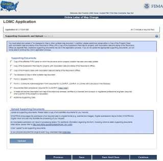
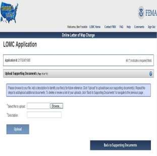
67 How can Floodplain Managers play a role in eloma? Help Promote eloma to Surveyors, Engineers, and Homeowners Help the LPs in their Communities Understand the Requirements of the eloma Process eloma Direct Property Owners to eloma Users in their Communities (FEMA Cannot Provide this Information) 79
68 Contacts and Links MIP FEMA MIP Help 80
69 The new Online Letter of Map Change (LOMC) Submission Process


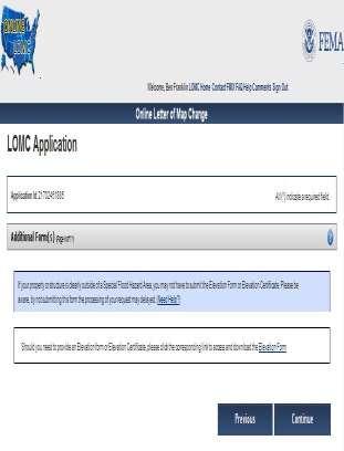
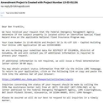
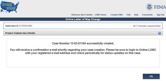
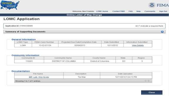
70 What is Online LOMC? Thanks for your interest in the Online LOMC tool! A CONVENIENT WAY TO REQUEST A LOMC FROM FEMA MT-EZ & MT-1 Forms MT-2 Forms Applicants may easily upload all information Add supporting documentation check the status of their LOMC application online 82
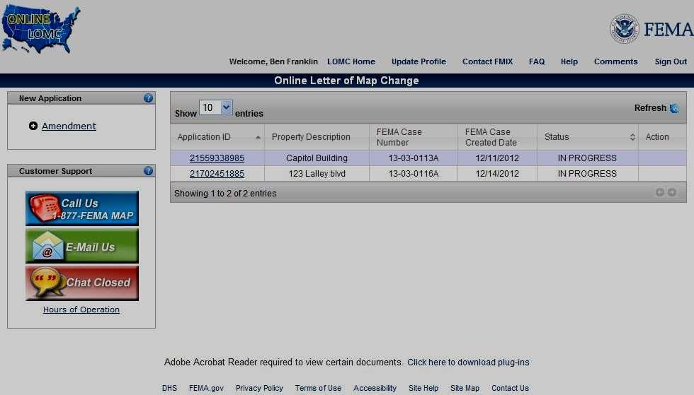
71 Introducing the Online LOMC Home or Property Owner Other Representatives of the Property Owner ONLINE LOMC Professional Surveyors Professional Engineers 83


72 eloma vs. Online LOMC eloma generates a determination within minutes. Licensed Professionals are subject to random audits. Online LOMCs are still subject to a 60 and 90-day turnaround from the date of all data received; however, the Online LOMC tool enables a quicker submission and turnaround. 84
73 The Many Benefits Why is Online LOMC better than filing by mail? Applicants bypass the step of mailing paper data to the LOMC Clearinghouse. 85


74 Online LOMC Features Access onlinelomc/signin Key Features Live Chat FAQ Help Text Contact FMIX By clicking Contact FMIX, you open the FMIX website in a separate window: ov/fhm/fmx_main.html 86


75 Start or review an Application 87


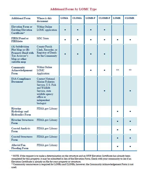
76 Additional Forms & Requirements 90
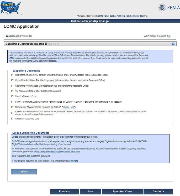
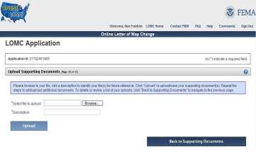


77 Supporting Documents and Upload 91
78 92


79 Upload Supporting Documents Penalty clause Certify that the information is correct to the best of your knowledge You cannot edit the information after you Generate Project 93


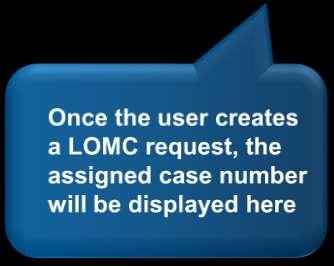
80 Project Submission Details After you generate a project, you will get a case number (different than an Application ID) 94


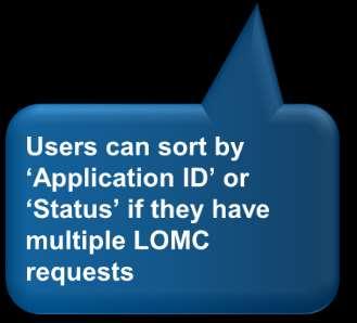
81 Application Status Page: Status Column Request Data/Fee Suspended Continue In Progress Status of Application FEMA is requesting additional data after receiving the application Application was suspended because the additional data was not submitted to FEMA within the allotted timeframe The applicant has not yet submitted the request The application and supporting documents are being reviewed by FEMA 95


82 Application ID on Status Page 96
83 Common Issues What common factors could slow down the processing of a LOMC application? 1 2 Submission of an unrecorded Deed or Plat 3 Submitting the request without elevation data 4 Submission of unknown or corrupt files Scanned data that is missing required information 97
84 Resources For more information on flood insurance, LOMCs, and Online LOMC, please visit these additional resources: Online LOMC fema.gov webpage Online LOMC FAQ Online LOMC Fact Sheet Amendments and Revisions webpage FloodSmart Official site of the National Flood Insurance Program 99
85 Questions and Answers 100

86 169
MT-1 Basics: A Comprehensive Overview of LOMAs and Discussion of Common Application Setbacks
 MT-1 Basics: A Comprehensive Overview of LOMAs and Discussion of Common Application Setbacks Introduction: Terminology MT-1s vs. MT-2s LOMAs vs. LOMRs What is a LOMC? Letters of Map Change (LOMCs) MT-1s
NFIP Mapping Issues. Wendy Lathrop, PLS, CFM. Cadastral Consulting, LLC
 NFIP Mapping Issues Cadastral Consulting, LLC NFIP Basic Objectives: Reduce the exposure to flood damages through the use of minimum standards for the placement and design of structures located in flood
Revisions to National Flood Insurance Program Maps
 MT-1 Revisions to National Flood Insurance Program Maps Application Forms and Instructions for Conditional and Final Letters of Map Amendment and Letters of Map Revision Based on Fill FEMA Form 81-87 Series
Role of the Local Floodplain Administrator
 2/22/2016 Role of the Local Floodplain Administrator Marsha Hilmes-Robinson Floodplain Administrator City of Fort Collins, Colorado mhilmesrobinson@fcgov.com 1 Partnership Engineer/Architect/ Contractor
Requirements for Construction on Properties in the Special Flood Hazard Area (SFHA)
") Requirements for Construction on Properties in the Special Flood Hazard Area (SFHA) Rev 010915 The website for the IDNR to request the EFARA (Electronic Floodplain Analysis/Regulatory Assessment is found
Requirements for Construction on Properties in the Special Flood Hazard Area (SFHA) Rev 010915 The website for the IDNR to request the EFARA (Electronic Floodplain Analysis/Regulatory Assessment is found
Now forget it all for the next 90 minutes.
 Karol L. Grove, PS Get ready to think outside of the box. Get ready to think about surveying, flood zones and flood insurance in a whole new light.. Think about everything you think you know about Elevation
If you have any questions or concerns please give us a call at , or Walter Jenkins at (ext 300).
.") FLORIDA ZONE SERVICES Flood Insurance and Zone Consulting 461 SE 3 rd Terrace Pompano Beach, FL 33060 Phone 954-290-7420 bspencer@florida-floodzone.com March 6, 2014 Dear Pebblebrook II Homeowner: We informing
FLORIDA ZONE SERVICES Flood Insurance and Zone Consulting 461 SE 3 rd Terrace Pompano Beach, FL 33060 Phone 954-290-7420 bspencer@florida-floodzone.com March 6, 2014 Dear Pebblebrook II Homeowner: We informing
FLOODPLAIN FAQ s. Last Update: June 2017
 FLOODPLAIN FAQ s Last Update: June 2017 What does FEMA stand for? Federal Emergency Management Agency - the operation of FEMA is to lead America to prepare for, prevent, respond to, and recover from disasters.
SUPERHERO!!! Elevation Certificate. You are about to go from SURVEYOR 2/18/2019
 Karol L. Grove Licensed Professional Surveyor Certified Floodplain Manager Elevation Certificate No longer the Animal it used to be When are they needed??? You are about to go from SURVEYOR to SUPERHERO!!!
Federal Emergency Management Agency
 Page 1 of 5 Issue Date: July 27, 2012 Effective Date: December 10, 2012 Case No.: 11-06-4512P Follows Conditional Case No.: 06-06-B789R LOMR-APP Federal Emergency Management Agency Washington, D.C. 20472
Federal Emergency Management Agency
 Page 1 of 4 Issue Date: August 1, 2012 Effective Date: December 13, 2012 Case No.: 12-06-0595P LOMR-APP Washington, D.C. 20472 LETTER OF MAP REVISION DETERMINATION DOCUMENT COMMUNITY AND REVISION INFORMATION
Floodplain Management 101: UNIT II. Maps & Flood Insurance Studies
 Floodplain Management 101: UNIT II Maps & Flood Insurance Studies Who is ASFPM? ASFPM stands for the Association of State Floodplain Managers A national organization of floodplain management professionals
Mistakes on Elevation Certificates
 Mistakes on Elevation Certificates What is the Base Flood Elevation (BFE) & how do you determine it? FIRM Map Panel? Flood Insurance Study? o Profile Sheet o Floodway Data Chart o Stillwater Chart Community
Federal Emergency Management Agency
 Page 1 of 4 Issue Date: October 2, 2017 Effective Date: October 2, 2017 Case No.: 17-09-2731P LOMR-APP Federal Emergency Management Agency Washington, D.C. 20472 LETTER OF MAP REVISION DETERMINATION DOCUMENT
Preliminary DFIRM Community Coordination (PDCC) Meeting Gilchrist & Levy Counties, FL. April 30, 2015
 Meeting Gilchrist & Levy Counties, FL. April 30, 2015") Preliminary DFIRM Community Coordination (PDCC) Meeting Gilchrist & Levy Counties, FL April 30, 2015 Agenda 1. Introductions 2. Study Process and Timeline 3. Overview of Preliminary Products 4. Overview
Preliminary DFIRM Community Coordination (PDCC) Meeting Gilchrist & Levy Counties, FL April 30, 2015 Agenda 1. Introductions 2. Study Process and Timeline 3. Overview of Preliminary Products 4. Overview
Floodplain Development Permit Application
 Floodplain Development Permit Application **All construction will also require a building permit** This is an application packet for a Floodplain Development Permit. Certain sections are to be completed
JAXGIS FEMA Flood Hazard Mapping -- Frequently Asked Questions
 Flood Hazard Zone Designations Summary Zones starting with the letter 'A' (for instance, Zone A, Zone AE, Zone AH, Zone AO) denote a Special Flood Hazard Area, which can also be thought of as the 100-year
Federal Emergency Management Agency
 Page 1 of 4 Date: January 27, 2015 COMMUNITY AND MAP PANEL INFORMATION COMMUNITY CITY OF FARGO, CASS COUNTY, LEGAL PROPERTY DESCRIPTION Lots 28, 32, 42 and 43, Block 2, Lot 9, Block 8, Legacy I Fourth,
Federal Emergency Management Agency
 Page 1 of 3 COMMUNITY AND MAP PANEL INFORMATION COMMUNITY CITY OF MARGATE CITY, ATLANTIC COUNTY, NEW JERSEY LEGAL PROPERTY DESCRIPTION A parcel of land, as described in Deed recorded in Book 4826, page
NFIP Overview Elevation Certificate Flood Insurance Rate Maps. By: Maureen O Shea, AICP, CFM State NFIP Coordinator
 NFIP Overview Elevation Certificate Flood Insurance Rate Maps By: Maureen O Shea, AICP, CFM State NFIP Coordinator Example of a flood failure Example of a flood failure Purposes of the NFIP Identify &
What Was Updated in 2004 in Hennepin Countywide Maps?
 What Was Updated in 2004 in Hennepin Countywide Maps? Combined the city and township maps into one countywide index Done by USACE Mainly digital capture of old floodplain boundaries; some spots with shifts
Durham County Preliminary Flood Hazard Data Public Meeting. July 28, 2016
 Durham County Preliminary Flood Hazard Data Public Meeting July 28, 2016 Why Are We Here New flood hazard data has been released as Preliminary for Durham County Statutory Due Process for review/comments
Federal Emergency Management Agency
 Page 1 of 4 Issue Date: April 26, 2013 DETERMINATION DOCUMENT COMMUNITY AND REVISION INFORMATION PROJECT DESCRIPTION BASIS OF REQUEST City of Coppell Dallas County Texas FILL HYDRAULIC ANALYSIS NEW TOPOGRAPHIC
Federal Emergency Management Agency
 Page 1 of 4 Issue Date: September 7, 2012 Effective Date: January 22, 2013 DETERMINATION DOCUMENT COMMUNITY COMMUNITY AND REVISION INFORMATION City of Lubbock Lubbock County Texas PROJECT DESCRIPTION CHANNELIZATION
Zone A. Non Studied Area? Where do we go? Establishing the BFE. Bridge Design 1/9/2019
 Karol L. Grove Licensed Professional Surveyor Certified Floodplain Manager 1 Establishing the BFE Zone A Where do we go? Non Studied Area? 2 Bridge Design 3 1 4 5 6 2 Look at the age of the culvert or
Taylor County, Florida Community Coordination and Outreach (CCO) Meeting
 Meeting") Taylor County, Florida Community Coordination and Outreach (CCO) Meeting Suwannee River Water Management District April 26, 2017 11:00AM to 12:00PM Taylor County Administration Building, 201 E. Green Street,
Taylor County, Florida Community Coordination and Outreach (CCO) Meeting Suwannee River Water Management District April 26, 2017 11:00AM to 12:00PM Taylor County Administration Building, 201 E. Green Street,
Abington Township Public Meeting
 Abington Township Public Meeting Flood Insurance Rate Map Update March 23, 2016 1 Meeting Agenda and Format Provide residents/property owners of Abington Township with information about the map update,
Enough about me! Topics Covered
 About Me Worked in land surveying since 1997 Employed by the City of Orlando since 2006 City of Orlando City Surveyor since February 2015 Certified Floodplain Manager since 2015 Florida Licensed Surveyor,
Federal Emergency Management Agency
 Page 1 of 4 Issue Date: April 11, 2013 Case No.: DETERMINATION DOCUMENT COMMUNITY AND REVISION INFORMATION PROJECT DESCRIPTION BASIS OF REQUEST Town Of Stratford Fairfield County Connecticut NO PROJECT
Appendix D - Floodplain Documents
 City of Aspen Urban Runoff Management Plan Appendix D - Floodplain Documents 1. Floodplain Development Permit 2. Elevation Certificate and Instructions 3. Floodproofing Certificate for Non-Residential
F E M A Mapping Changes. FEMA Mapping Changes. National Flood Insurance Program
 FEMA Mapping Changes National Flood Insurance Program 1 Welcome to FEMA Mapping Changes! We will get started in a few minutes. Meanwhile, let s perform a warm up exercise. 2 1 Training Agenda Section 1-
210 W Canal Dr Palm Harbor, FL 34684
 Flood Analysis Memo Property Address In Partnership with: ** This property is within a high risk flood zone ** BFE = 6 ft This property is located in the FEMA designated high-risk zone, Zone AE - an area
National Flood Insurance Program (NFIP) for Real Estate Professionals
 for Real Estate Professionals") National Flood Insurance Program (NFIP) for Real Estate Professionals 1 Joshua Oyer, CFM Outreach Specialist NFIP State Coordinator s Office at the Texas Water Development Board 2 Outline Introduction
National Flood Insurance Program (NFIP) for Real Estate Professionals 1 Joshua Oyer, CFM Outreach Specialist NFIP State Coordinator s Office at the Texas Water Development Board 2 Outline Introduction
Herkimer County, New York Flood Hazard Mapping Status Report for Property Owners
 Herkimer County, New York Flood Hazard Mapping Status Report for Property Owners Herkimer County, New York Flood Hazard Mapping Status Report for Property Owners FLOOD INSURANCE Who Should Purchase Flood
Federal Emergency Management Agency
 Page 1 of 5 Issue Date: June 21, 2013 Follows Conditional Case No.: 04-06-A148R DETERMINATION DOCUMENT COMMUNITY COMMUNITY AND REVISION INFORMATION City of Irving Dallas County Texas FILL PROJECT DESCRIPTION
10526 Bermuda Isle Dr. Tampa, FL 33647
 Flood Analysis Memo Property Address In Partnership with: ** This property is NOT within a high-risk flood zone ** This property is located in a FEMA low-risk zone designated as Zone X - an area of minimal
Floodplain Management 101. Mississippi Emergency Management Agency Floodplain Management Bureau
 Floodplain Management 101 Mississippi Emergency Management Agency Floodplain Management Bureau Stafford Act The Stafford Disaster Relief and Emergency Assistance Act (Stafford Act) (Public Law 100-707)
INSTRUCTIONS FOR COMPLETING THE APPLICATION FORMS FOR CONDITIONAL LETTERS OF MAP REVISION AND LETTERS OF MAP REVISION
 INSTRUCTIONS FOR COMPLETING THE APPLICATION FORMS FOR CONDITIONAL LETTERS OF MAP REVISION AND LETTERS OF MAP REVISION GENERAL In 1968, the U.S. Congress passed the National Flood Insurance Act, which created
Nassau County, Florida Consultation Coordination Officer (CCO) Meeting. February 24, 2016 Fernandina Beach, Florida
 Meeting. February 24, 2016 Fernandina Beach, Florida") Nassau County, Florida Consultation Coordination Officer (CCO) Meeting February 24, 2016 Fernandina Beach, Florida Agenda Introductions Coastal Study Update Study Process and Timeline Flood Insurance Implications
Nassau County, Florida Consultation Coordination Officer (CCO) Meeting February 24, 2016 Fernandina Beach, Florida Agenda Introductions Coastal Study Update Study Process and Timeline Flood Insurance Implications
INSTRUCTIONS FOR COMPLETING THE APPLICATION FORMS FOR CONDITIONAL LETTERS OF MAP REVISION AND LETTERS OF MAP REVISION
 INSTRUCTIONS FOR COMPLETING THE APPLICATION FORMS FOR CONDITIONAL LETTERS OF MAP REVISION AND LETTERS OF MAP REVISION GENERAL In 1968, the U.S. Congress passed the National Flood Insurance Act, which created
Federal Emergency Management Agency
 Page 1 of 5 Issue Date: October 16, 2014 Effective Date: March 2, 2015 Case No.: 14-09-2279P LOMR-APP Federal Emergency Management Agency Washington, D.C. 20472 LETTER OF MAP REVISION DETERMINATION DOCUMENT
SECTION 9: MAPS AND DATA
 SECTION 9: MAPS AND DATA Contents 9.1. NFIP Maps and Data... 9-2 9.1.1. Adopting and enforcing NFIP floodplain maps and data... 9-2 9.1.2. Adopting and enforcing more restrictive data... 9-2 9.1.3. Annexations...
Federal Emergency Management Agency
 Page 1 of 6 Issue Date: October 24, 2012 Effective Date: March 7, 2013 Case No.: LOMR-APP DETERMINATION DOCUMENT COMMUNITY AND REVISION INFORMATION PROJECT DESCRIPTION BASIS OF REQUEST City of Lubbock
Table 1: Federal, State and Local Government Rules applicable to LOMRs/CLOMRS submittal
 MnDNR LOMC Guide This document has been prepared by the Minnesota Department of Natural Resources floodplain staff and is intended to provide assistance with LOMR/CLOMR submittals. This information is
Floodplain Development Permit Application
 Floodplain Development Permit Application City of Jonesboro, AR This is an application packet for a Floodplain Development Permit. Certain sections are to be completed by the Applicant, and certain sections
Updates to Maine Coastal Flood Insurance Rate Maps (FIRM s): What a Local Official Should Know. Presented by: Steve Johnson, P.E.
: What a Local Official Should Know. Presented by: Steve Johnson, P.E.") Updates to Maine Coastal Flood Insurance Rate Maps (FIRM s): What a Local Official Should Know Presented by: Steve Johnson, P.E. Town Engineer October 4, 2018 Introduction Federal Emergency Management
Updates to Maine Coastal Flood Insurance Rate Maps (FIRM s): What a Local Official Should Know Presented by: Steve Johnson, P.E. Town Engineer October 4, 2018 Introduction Federal Emergency Management
10526 Bermuda Isle Dr. Tampa, FL 33647
 Flood Analysis Memo Property Address 10526 Bermuda Isle Dr. In Partnership with: ** This property is NOT within a high-risk flood zone ** 10526 Bermuda Isle Dr. BFE = 35 ft This property is located in
SUPERHERO!!! You are about to go from SURVEYOR 1/9/2019. Karol L. Grove Licensed Professional Surveyor Certified Floodplain Manager
 Karol L. Grove Licensed Professional Surveyor Certified Floodplain Manager 1 You are about to go from SURVEYOR to SUPERHERO!!! 2 Get ready to think outside of the box. Get ready to think about flood zones
FREQUENTLY ASKED QUESTION ABOUT FLOODPLAINS Michigan Department of Environmental Quality
 FREQUENTLY ASKED QUESTION ABOUT FLOODPLAINS Michigan Department of Environmental Quality WHAT IS A FLOOD? The National Flood Insurance Program defines a flood as a general and temporary condition of partial
National Flood Insurance Program
 National Flood Insurance Program FEMA ELEVATION CERTIFICATES PA Surveyor Training Presented by Thomas F. Smith, PE, PLS January 22, 2018 1 FEMA Region III Mitigation Division Floodplain Management & Insurance
Federal Emergency Management Agency
 Federal Emergency Management Agency Washington, D. C. 24 72 December 29, 214 CERTIFIED MAIL RETURN RECEIPT REQUESTED The Honorable Gary Wescott Mayor, City of Stevens Point 1515 Strongs A venue Stevens
Federal Emergency Management Agency
 Page 1 of 5 Issue Date: October 19, 2012 Effective Date: March 4, 2013 Case No.: 12-06-3459P LOMR-APP Washington, D.C. 20472 LETTER OF MAP REVISION DETERMINATION DOCUMENT COMMUNITY AND REVISION INFORMATION
Federal Emergency Management Agency
 Page 1 of 5 Issue Date: October 28, 2009 Follows Conditional Case No.: 08-08-0612R DETERMINATION DOCUMENT COMMUNITY AND REVISION INFORMATION PROJECT DESCRIPTION BASIS OF REQUEST COMMUNITY Lincoln County
Federal Emergency Management Agency
 Page 1 of 6 Issue Date: September 27, 2010 Effective Date: February 14, 2011 Follows Conditional Case No.: 08-08-0873R DETERMINATION DOCUMENT COMMUNITY AND REVISION INFORMATION PROJECT DESCRIPTION BASIS
Federal Emergency Management Agency
 Page 1 of 5 Issue Date: April 2, 2015 DETERMINATION DOCUMENT COMMUNITY AND REVISION INFORMATION PROJECT DESCRIPTION BASIS OF REQUEST Ventura County California NO PROJECT UPDATE COMMUNITY (Unincorporated
St. Johns County, Florida Consultation Coordination Officer (CCO) Meeting. August 31, 2016 St. Augustine, Florida
 Meeting. August 31, 2016 St. Augustine, Florida") St. Johns County, Florida Consultation Coordination Officer (CCO) Meeting August 31, 2016 St. Augustine, Florida Agenda Introductions Coastal Study Update Study Process and Timeline Flood Insurance Implications
St. Johns County, Florida Consultation Coordination Officer (CCO) Meeting August 31, 2016 St. Augustine, Florida Agenda Introductions Coastal Study Update Study Process and Timeline Flood Insurance Implications
Federal Emergency Management Agency
 Page 1 of 4 Issue Date: November 16 2016 Effective Date: March 31 2017 Case No: 16-06-2056P LOMR-APP Follows Conditional Case No: 10-06-3320R Federal Emergency Management Agency Washington DC 20472 LETTER
Chapter 5 Floodplain Management
 Chapter 5 Floodplain Management Contents 1.0 Introduction... 1 2.0 Floodplain Management and Regulation... 1 2.1 City Code... 1 2.2 Floodplain Management... 1 2.3 Level of Flood Protection... 2 2.3.1 Standard
LOCAL OFFICIALS MEETING Lake Wausau Physical Map Revision MARATHON COUNTY, WISCONSIN FEBRUARY 9, 2017
 LOCAL OFFICIALS MEETING Lake Wausau Physical Map Revision MARATHON COUNTY, WISCONSIN FEBRUARY 9, 2017 Welcome & Introduction Michelle Staff Floodplain Management Policy Coordinator, WDNR Michelle.Staff@Wisconsin.gov
Kevin Wagner Maryland Department of the Environment
 Kevin Wagner Maryland Department of the Environment Topics Overview of the National Flood Insurance Program (NFIP) Mapping Regulations Insurance Mitigation Community Rating System (CRS) Questions Know
Questions about the National Flood Insurance Program
 Questions about the National Flood Insurance Program Federal Emergency Management Agency (FEMA) Questions and Answers What is the National Flood Insurance Program (NFIP)? The NFIP is a Federal program
Federal Emergency Management Agency
 Page 1 of 4 Issue Date: February 14, 2013 Effective Date: June 28, 2013 DETERMINATION DOCUMENT COMMUNITY AND REVISION INFORMATION City of Sunny Isles Beach Miami-Dade County Florida PROJECT DESCRIPTION
North Carolina Department of Public Safety Emergency Management Risk Management
 North Carolina Department of Public Safety Emergency Management Risk Management Roy Cooper, Governor Erik A. Hooks, Secretary Michael A. Sprayberry, Director INSTRUCTIONS FOR COMPLETING THE NORTH CAROLINA
History of Floodplain Management in Ascension Parish
 History of Floodplain Management in Ascension Parish presented by: Kara Moree Floodplain Coordinator February 6, 2012 Floodplain 101 Floodplain 101 Base or 1% Flood: A flood having a 1% chance of being
COLLIER COUNTY FLOODPLAIN MANAGEMENT
 COLLIER COUNTY FLOODPLAIN MANAGEMENT FREQUENTLY ASKED QUESTIONS The following information is based on common questions from the public. If you have a specific question or need further information, please
MOKAN CRS Users Group Activity 310, Elevation Certificates Packet
 http://mokan.stormsmart.org/ MOKAN CRS Users Group Activity 310, Elevation Certificates Packet This packet includes the following documents to be used as applicable to your community: EC checklist EC correction
Federal Emergency Management Agency
 Federal Emergency Management Agency Washington, D.C. 20472 August 16, 2016 CERTIFIED MAIL IN REPLY REFER TO: RETURN RECEIPT REQUESTED Case No.: 16-07-1180P Community Name: City of Overland Park, KS The
Duval County, Florida Consultation Coordination Officer (CCO) Meeting. January 25, 2017 Jacksonville, Florida
 Meeting. January 25, 2017 Jacksonville, Florida") Duval County, Florida Consultation Coordination Officer (CCO) Meeting January 25, 2017 Jacksonville, Florida Agenda Introductions Coastal Study Update Study Process and Timeline Flood Insurance Implications
Duval County, Florida Consultation Coordination Officer (CCO) Meeting January 25, 2017 Jacksonville, Florida Agenda Introductions Coastal Study Update Study Process and Timeline Flood Insurance Implications
Door County Floodplain Program Informational Meeting
 Door County Floodplain Program Informational Meeting Door County Land Use Services Department Wisconsin Department of Natural Resources January 15, 2018 Floodplain = Land affected by flood event with a
CONTRA COSTA COUNTY FLOODPLAIN MANAGEMENT PROGRAM
 CONTRA COSTA COUNTY FLOODPLAIN MANAGEMENT PROGRAM Answers to Commonly Asked Questions and A Guide for Residential Construction Within Special Flood Hazard Areas Revised February 2015 Introduction Ninety
Flood Analysis Memo. 629 Orangewood Dr. Dunedin, FL BFE = 21 ft
 Flood Analysis Memo Property Address 629 Orangewood Dr. In Partnership with: ** This property is NOT within a high-risk flood zone ** 629 Orangewood Dr. BFE = 21 ft This property is located in the FEMA
Guidelines and Specifications for Flood Hazard Mapping Partners. Introduction
 Introduction INT.1 Purpose and Scope of Document The Federal Emergency Management Agency (FEMA), as the agency responsible for administration of the National Flood Insurance Program (NFIP), conducts flood
Pre-Development Floodplain Application
 Pre-Development Floodplain Application The Department of Planning, at the recommendation of FEMA, is now requiring completion of a Pre- Development Floodplain Application for all properties in the regulated
YOLO COUNTY FLOODPLAIN MANAGEMENT PROGRAM
 YOLO COUNTY FLOODPLAIN MANAGEMENT PROGRAM Answers to Commonly Asked Questions and A Guide for Residential Construction Within Special Flood Hazard Areas The automatic entry and exit of flood water); Or
Federal Emergency Management Agency
 Page 1 of 4 Issue ate: May 18, 2012 Follows Conditional Case No.: 08-06-1597R ETERMINATION OCUMENT COMMUNITY AN REVISION INFORMATION PROJECT ESCRIPTION BASIS OF REQUEST COMMUNITY Harris County Texas (Unincorporated
W October 1, Write Your Own (WYO) Principal Coordinators and the National Flood Insurance Program (NFIP) Servicing Agent
 Principal Coordinators and the National Flood Insurance Program (NFIP) Servicing Agent") U.S. Department of Homeland Security 500 C St. SW Washington, D.C. 20472 W-14053 October 1, 2014 MEMORANDUM FOR: Write Your Own (WYO) Principal Coordinators and the National Flood Insurance Program (NFIP)
U.S. Department of Homeland Security 500 C St. SW Washington, D.C. 20472 W-14053 October 1, 2014 MEMORANDUM FOR: Write Your Own (WYO) Principal Coordinators and the National Flood Insurance Program (NFIP)
a) Ensure public safety through reducing the threats to life and personal injury.
 Ensure public safety through reducing the threats to life and personal injury.") SECTION VII: FLOODPLAIN DISTRICT 7-1 Statement Of Purpose The purposes of the Floodplain District are to: a) Ensure public safety through reducing the threats to life and personal injury. b) Eliminate
SECTION VII: FLOODPLAIN DISTRICT 7-1 Statement Of Purpose The purposes of the Floodplain District are to: a) Ensure public safety through reducing the threats to life and personal injury. b) Eliminate
CONDOMINIUMS I. METHODS OF INSURING CONDOMINIUMS. Important Notice to Agents/Producers:
 Previous Section Main Menu Table of Contents Next Section Important Notice to Agents/Producers: CONDOMINIUMS Boards of directors of condominium associations typically are responsible under their by-laws
Skagit County Flood Insurance Study Update. Ryan Ike, CFM FEMA Region 10
 Skagit County Flood Insurance Study Update Ryan Ike, CFM FEMA Region 10 Skagit County Flood Insurance Study Process Overview Process, Schedule, & Deliverables Base Flood Elevations, Modeling, & Levees
Federal Emergency Management Agency
 Page 1 of 6 Issue Date: May 13 2016 Case No.: Follows Conditional Case No.: 14-05-0595R DETERMINATION DOCUMENT COMMUNITY AND REVISION INFORMATION PROECT DESCRIPTION BASIS OF REQUEST COMMUNITY Village of
9/20/2016. Orange County Preliminary FIRM / Consultation Coordination Officer (CCO) Meeting
 Meeting") Orange County Preliminary FIRM / Consultation Coordination Officer (CCO) Meeting Open Pacific Coast Study September 21 and 22, 2016 1 Welcome and Introductions Preliminary FIRM / CCO Meeting Orange County
Orange County Preliminary FIRM / Consultation Coordination Officer (CCO) Meeting Open Pacific Coast Study September 21 and 22, 2016 1 Welcome and Introductions Preliminary FIRM / CCO Meeting Orange County
Federal Emergency Management Agency
 Page 1 of 4 Issue Date: April 29, 2011 DETERMINATION DOCUMENT COMMUNITY COMMUNITY AND REVISION INFORMATION City of Simi Valley Ventura County California PROJECT DESCRIPTION NO PROJECT BASIS OF REQUEST
If you have any questions or concerns please give us a call at , or Walter Jenkins at (ext 300).
.") FLORIDA FLOODZONE SERVICES Flood Insurance and Zone Consulting 461 SE 3 rd Terrace Pompano Beach, FL 33060 Phone 954-290-7420 bspencer@florida-floodzone.com March 15, 2010 Dear Portofino Lakes Homeowner:
FLORIDA FLOODZONE SERVICES Flood Insurance and Zone Consulting 461 SE 3 rd Terrace Pompano Beach, FL 33060 Phone 954-290-7420 bspencer@florida-floodzone.com March 15, 2010 Dear Portofino Lakes Homeowner:
DEC NFIP Regional Coordinators REGIONAL OFFICES. DEC NFIP Regional Coordinators REGIONAL OFFICES 10/26/2016. DEC Floodplain Coordinators
 1 2 Flood Maps, FEMA Elevation Certificates and Letters of Map Change Floodplain Management Section Bureau of Flood Protection and Dam Safety Introduction to the National Flood Insurance Program NYSAPLES
SPECIAL CERTIFICATIONS
 SPECIAL CERTIFICATIONS This section presents detailed instructions for the completion of the National Flood Insurance Program (NFIP) Elevation Certificate (EC) and the NFIP Floodproofing Certificates.
Maryland Model Floodplain Management Ordinance (May, 2014) MODEL NOTES
 MODEL NOTES") Maryland Model Floodplain Management Ordinance (May, 2014) MODEL NOTES The model floodplain management ordinance that most Maryland communities have used as the basis for their regulations since the early
Maryland Model Floodplain Management Ordinance (May, 2014) MODEL NOTES The model floodplain management ordinance that most Maryland communities have used as the basis for their regulations since the early
Dealing With Unnumbered A Zones in Maine Floodplain Management
 Dealing With Unnumbered A Zones in Maine Floodplain Management The following is a list of acceptable methods that the State Floodplain Management Coordinator and the Federal Emergency Management Agency
Introduction to Lender Compliance. National Flood Insurance Program
 Introduction to Lender Compliance National Flood Insurance Program 1 Welcome to Introduction to Lender Compliance! We will get started in a few minutes. Meanwhile, let s perform a warm up exercise. 2 1
BEING PREPARED FOR MAP CHANGES What to Know; What to Say National Flood Conference May 16, 2016
 BEING PREPARED FOR MAP CHANGES What to Know; What to Say National Flood Conference May 16, 2016 0 Discussion Topics Risk MAP Program Background Eric Simmons FEMA Region 9 Map Change Rating Options Edie
Article 23-6 FLOODPLAIN DISTRICT
 AMENDING THE CODE OF THE CITY OF PITTSFIELD CHAPTER 23, ZONING ORDINANCE SECTION I That the Code of the City of Pittsfield, Chapter 23, Article 23-6 Floodplain District, shall be replaced with the following:
l ederal Emergency Management Agency
 past.it ~[.~hn 014 854 482 l ederal Emergency Management Agency August 16, 2011 CERTIFIED MAIL RETURN RECEIPT REQUESTED The Honorable Frank Mann Chairman, Lee County Board of Commissioners Post Office
ADDITIONAL GUIDANCE FROM FEMA
 APPENDIX G ADDITIONAL GUIDANCE FROM FEMA Effects of Non-Participation in the National Flood Insurance Program...3 NFIP Restrictions on Federal Assistance in Sanctioned Communities...4 Policy Guidance:
Introduction to the National Flood Insurance Program: A Guide for Coastal Property Owners MAINE BEACHES CONFERENCE 2017
 Introduction to the National Flood Insurance Program: A Guide for Coastal Property Owners MAINE BEACHES CONFERENCE 2017 SUE BAKER, CFM STATE NFIP COORDINATOR MAINE DEPT OF AGRICULTURE, CONSERVATION & FORESTRY
Flood Map Revisions. Town of Nags Head Public Information and Input Session. December 14, 2016, 6 pm
 Flood Map Revisions Town of Nags Head Public Information and Input Session December 14, 2016, 6 pm Flood Map Revisions New preliminary flood maps released for Dare County June 30, 2016 www.nagsheadnc.gov/floodmaps
October 1, Write Your Own (WYO) Principal Coordinators and the National Flood Insurance Program (NFIP) Servicing Agent
 Principal Coordinators and the National Flood Insurance Program (NFIP) Servicing Agent") U.S. Department of Homeland Security Washington, D.C. 20472 October 1, 2015 MEMORANDUM FOR: Write Your Own (WYO) Principal Coordinators and the National Flood Insurance Program (NFIP) Servicing Agent FROM:
U.S. Department of Homeland Security Washington, D.C. 20472 October 1, 2015 MEMORANDUM FOR: Write Your Own (WYO) Principal Coordinators and the National Flood Insurance Program (NFIP) Servicing Agent FROM:
Chapter 7 Appendix B: National Flood Insurance Program Summary for Kaua'i County, 2015 Update
 Chapter 7 Appendix B: National Flood Insurance Program Summary for Kaua'i County, 2015 Update Topic Considerations Description INSURANCE SUMMARY STAFF RESOURCES How many NFIP policies are in Kaua i County?
Pinellas County Flood Map Information Service & Real Estate Disclosure Program Training January 26, 2017 COMMON FLOODPLAIN ACRONYMS
 FEMA ASFPM BFE CAV Pinellas County Flood Map Information Service & Real Estate Disclosure Program Training COMMON FLOODPLAIN ACRONYMS Federal Emergency Management Agency Association of State Floodplain
Florida Division of Emergency Management
 2017 FLOODPLAIN MANAGEMENT IN FLORIDA Florida Division of Emergency Management Bureau of Mitigation State Floodplain Management Office 2555 Shumard Oak Boulevard, Tallahassee, FL 32399 www.floridadisaster.org/mitigation
Using GISWeb to Determine Your Property s Flood Zone
 Using GISWeb to Determine Your Property s Flood Zone 1. In a new browser window, go to http://www.co.santacruz.ca.us/departments/geographicinformationsystemsgis.aspx 2. Click on GISWeb - GIS Mapping Application
Floodplain Management Annual Conference Atlanta, Georgia April 2017
 Floodplain Management 2017 Annual Conference Atlanta, Georgia April 2017 Floodplain Mapping and Flood Zones Zone Deisgnations: Zone A: No base flood elevations have been determined it is an approximated