DEC NFIP Regional Coordinators REGIONAL OFFICES. DEC NFIP Regional Coordinators REGIONAL OFFICES 10/26/2016. DEC Floodplain Coordinators
|
|
|
- Ronald Alexander
- 5 years ago
- Views:
Transcription

 226-5447 mary.binder@dec.ny.")

1 1 2 Flood Maps, FEMA Elevation Certificates and Letters of Map Change Floodplain Management Section Bureau of Flood Protection and Dam Safety Introduction to the National Flood Insurance Program NYSAPLES Annual Surveyors Conference and Exhibition January 20, 2017 DEC Floodplain Coordinators Central Office Main Number: floodplain@dec.ny.gov 3 DEC NFIP Regional Coordinators REGIONAL OFFICES 4 Bill Nechamen, CFM (518) Betty Ketcham (518) David Sherman (518) Brad Wenskoski (518) Western New York Flood Hub: Assists in Regions 6-9 Mary Binder (585) mary.binder@dec.ny.gov Region 1: Long Island Eric Star, Ryan Porciello, Region 2: New York City Jean Occidental DEC NFIP Regional Coordinators REGIONAL OFFICES 5 DEC NFIP Regional Coordinators REGIONAL OFFICES 6 Region 3: New Paltz Mark Lewis Region 3: White Plains Berhanu Gonfa ext372 Region 4: Schenectady Tom Blanchard, CFM Region 5: Warrensburg Rob Streeter Region 6: Utica Albert Ash


2 DEC NFIP Regional Coordinators REGIONAL OFFICES 7 DEC NFIP Regional Coordinators REGIONAL OFFICES 8 Region 7: Syracuse Kevin Delaney Region 7: Kirkwood Dan Fuller, Ben Girtain Plowe Region 8: Horseheads Brad Chaffee Region 8: Avon Karis Manning Region 9: Buffalo Jim Vogel Workshop Comments More Comments This workshop is intended to provide an introduction to the NFIP, and details that surveyors need to know. Topics pertain to the minimum standards of the NFIP only, as well as NYS Building Code requirements NYS building code incorporates most, but not all, of those standards Other related federal/state programs will not be covered Subject matter applies to the special flood hazard area, i.e., The 100-year floodplain 1.0 % flood probability per year Please ask questions We will go over: NFIP History and Basics Obtaining and using Flood Maps and Studies Key Elevation Determination Development Requirements Elevation Certificates Letters of Map Change And More! Some Resources DEC workshops NYS Floodplain and Stormwater Managers Association Association of State Floodplain Managers FEMA NFIP Desk Reference Self education and experience Litigation 11 Information on the Web NFIP Forms NFIP Technical Bulletins Mapping Guidelines and Specifications FEMA Map Service Center Flood Insurance Library Floodplain Management Information
3 The National Flood Insurance Act of 1968 The National Flood Insurance Act created the Federal Insurance Administration and directed it to: Identify flood-prone areas within the U.S. Establish flood-risk zones within those areas. Require new and substantially improved buildings be constructed in ways that minimize flood damage. Transfer cost of private property flood losses from taxpayer to property owner. 13 The Three-Legged Stool The NFIP balances three related program areas: Flood Hazard Identification (mapping). Floodplain Management (regulations such as building codes and zoning). Flood Insurance (availability of insurance for property owners in participating communities). F l o o d I n s u r a n ce Flood Disaster Protection Act of 1973 Significant expansion of the NFIP and required: Acceleration of flood insurance studies Notification of flood-prone communities Mandatory purchase requirement Participation in the NFIP for Federal Assistance National Flood Insurance Reform Act of 1994 Expanded flood insurance purchase requirements / Lender penalties for non-compliance Requires lenders to determine if structure is located in a flood hazard area Flood disaster assistance requires maintenance of flood insurance policy Increased Cost of Compliance -- allows insurance payment to elevate, demolish or relocate structure Biggert-Waters Flood Insurance Reform Act of 2012 Phasing Out of Subsidized Flood Insurance Rates Makes it even more crucial to build to proper elevations! Mapping Changes including Future Conditions Mapping Levee Evaluation Procedures 17 Homeowners Flood Insurance Affordability Act of 2014 Eliminates some of the 2012 Changes Property Sales; New Policies; Grandfathering Establishes floor and ceiling of rate hikes: 5% to 18% Annual Rate Increases for Pre-FIRM Properties Until Actuarial Rates are Reached Annual Surcharge: $25 Primary Residential Properties $250 Other Properties Structures Mapped Into SFHA Get PRP, then up to 18% annual increases until X zone rate is reached FEMA must Strive to Limit Rates to No More than 1% of Coverage Many Categories, Particularly Coastal V Zones, Already Significantly Above That More Elevation Certificates Required! 18 3
4 19 20 NFIP Goals Reduce loss of life and property caused by flooding Reduce rising disaster relief costs caused by flooding Make Federally backed flood insurance coverage available to property owners Accomplishing NFIP Goals Require new construction and substantial improvements to be flood resistant Guide future development away from flood hazard areas Transfer flood loss costs from taxpayers to floodplain property owners Prohibit new development in designated floodways that would increase flood heights Roles Federal State Local Private Federal Role Risk identification/mapping Establish development/building standards Provide for flood insurance coverage State Role Establish development/building standards State building code Model local law for flood damage prevention Provide technical assistance to local communities/agencies Under contract with FEMA, evaluate and document community/agency floodplain management activities 23 Local Role Adopt local floodplain management laws Issue or deny development/building permits Inspect development Maintain records 24 4


5 25 26 Major Categories of Floods Floods and Floodplains Riverine Flooding Overbank Flooding Flash Flooding Riverine Erosion Ice Jam Flooding Coastal Flooding Coastal Storms Coastal Erosion Tsunamis Lake Flooding Shallow Flooding Sheet Flow Ponding Urban Drainage Overbank Flooding Flash Flooding Half of Flooded Businesses Never Re Open Riverine Erosion 29 Riverine Erosion 30 5


6 31 32 Flood Forces HYDROSTATIC FORCES ft. of standing water can collapse walls Basement Walls and Floors are Particularly Vulnerable Water weighs 62.4 lbs/ft 3 or 8.4 lbs/gallon 35 Buoyancy Forces 36 Buoyancy Forces 6


7 HYDRODYNAMIC FORCES 37 Raging floodwaters only a foot deep can sweep an adult away Hydrodynamic Forces 38 Water moving at 4 mph has same force as a 100 mph wind. Debris Impact Forces 39 Debris Impact Forces 40 Soaking Sediment and Contaminants 7
8 43 44 Premise of the NFIP Standards Build it Up Build it Back Protect It Remember: It s not a question of IF, it s WHEN will there be a flood. Key Concepts in Elevation Determinations Lowest Floor Lowest Floor Elevations Slab Foundation 45 Lowest Floor Elevations Crawl-Space Foundation 46 Lowest Floor Opening (typical) Lowest Floor Lowest Floor Elevations Split Level 47 Lowest Floor Elevations Basement Foundation 48 Garage Lowest Floor Lowest Floor Basement 8
 The lowest enclosed area, including the basement, must be at or above the Base Flood Elevation (BFE) Plus Two Feet Non-residential buildings may be flood proofed")
9 Pile Foundation 49 Elevation Requirements 50 Requirements in A and V Zones Elevated Foundations Lowest Floor A Zone Lowest Floor V Zone Minimum Standards for NFIP Building Requirements AE Zone Building Requirements (BFE Available) The lowest enclosed area, including the basement, must be at or above the Base Flood Elevation (BFE) Plus Two Feet Non-residential buildings may be flood proofed Require Flood Proofing Certificate from PE or Architect No development in the regulatory floodway that would raise BFE FEMA and the State encourage Local Communities to adopt higher standards Residential Building Code: R Building Code Section : Refers to ASCE 24 Floodway Schematic FLOODWAY FRINGE 100 YEAR FLOODPLAIN FLOODWAY SURCHARGE FLOODWAY + FLOODWAY FRINGES = FLOODPLAIN SURCHARGE NOT TO EXCEED 1.0 FOOT Floodway Example Elevation Requirements: Zone A- NO Base Flood Elevation Data All new construction or substantial improvement, shall have the lowest floor, including basement, elevated at least three feet above the highest adjacent grade. (DEC Model Local Law; NYS Residential Building Code, R ) For subdivisions or other developments over 50 lots or 5 acres, applicant must provide flood elevation data and build accordingly. (FEMA Regulations: 44CFR60.3(b)(3)) 9


10 Elevation Requirements: Zone A- NO Base Flood Elevation Data 55 Unnumbered A ZONE REFERENCE LEVELS (DEPTH 3 FEET) HIGHEST ADJACENT GRADE 56 If there is a Base Flood Elevation from a reputable source, then use it. NYS DEC Corps of Engineers NRCS Historic Flood Data Other engineering study, including for development of over 5 acres or over 50 lots LOWEST FLOOR REFERENCE LEVEL FINISHED GRADE 3 FEET HIGHEST ADJACENT GRADE - HIGHEST NATURAL GRADE ADJACENT TO THE FOOTPRINT OF THE BUILDING PRIOR TO CONSTRUCTION Elevation Requirements for Zone VE All new construction and substantial improvement shall be elevated on adequately anchored pilings or columns and securely anchored to such pilings or columns so that the lowest horizontal portion of the structural members of the lowest floor is elevated to or above the BFE plus 2. 2 Freeboard BFE LOWEST FLOOR LOWEST HORIZONTAL STRUCTURAL BEAM Residential Building Code: R324.3 Building Code Section : Refers to ASCE Openings in Crawl Spaces THE WAVE PASSES UNDER THE BUILDING...UNIMPEDED Standards No fewer than two openings Lowest point no higher than one foot above lowest adjacent finished outside grade Minimum total size of openings: one square inch per square foot of enclosed space Louvers, valves or screens allowed, provided the permit automatic entry and exit of floodwaters 10


 on all")


11 61 62 Definition of Basement Basement or Cellar is that portion of a building having its floor subgrade (below ground level) on all sides. Flood Insurance Studies and Flood Insurance Rate Maps Map Panel Information Scale and North Arrow Area Mapped Communities and Community Numbers Community Panel Number Map Date Historic Map Dates 11


12 67 68 Reading a FIRM Some Map Features Open Map Index and Find Panel Note: Older maps are by Community. Newer maps are by county. Moving towards County-wide or watershed mapping statewide. Wavy Line used when Flood Elevation Varies along Watercourse; Label used when flood elevation is uniform over large area Lake Areas Note AE zones surrounding several lakes. Lakes with AE zones or A followed by a number have a base flood elevation BFE is a label for the entire flood zone For large lakes, there may be more than one bfe. Could be separated by a white line. A zones by themselves have no designated BFE DEC may have BFE for lakes without mapped elevation Elevation Reference Marks Older Flat Maps 12


")
13 73 74 Flood Boundary & Floodway Map DFIRM Coastal Areas: Stillwater and Wave Elevations Coastal Areas: Limit to Moderate Wave Action Wave heights during storm surges are analyzed along transects (crosssection lines) along a coast. 13


14 79 80 Coastal Area DFIRM Limit to Moderate Wave Action (LiMWA) Coastal Area DFIRM: Barrier Island Transect Schematic Each transact is a cross-section from a point on the shoreline to a point inland. V Zone Wave Heights Greater Than 3 Feet A Zone Wave Heights Less Than 3 Feet 100 Year Stillwater Mean Sea Level Base Flood Elevation Including Wave Effects Shore Line Sand Dune Wooded Region Overland Buildings Wind Fetch After analyzing wave heights along each transect, wave elevations were interpolated between transects. Various source data were used in the interpolation, including topographic maps, beach profiles, aerial photos, and engineering judgment. Controlling features affecting the elevations were identified and considered in relation to their positions at a particular transect and their variation between transects Transect Descriptions Transect Data 14

15 85 86 Flood Insurance Study A flood insurance study (FIS) is a compilation and presentation of hydrologic and hydraulic determinations made for specific watercourses within a municipality. The FIS delineates flood hazard areas and establishes flood elevations thereby serving as the basis for regulating floodplain development and providing flood insurance FLOOD INSURANCE STUDY FIS NARRATIVE Appraises a community's flood problems Estimates flood flow frequency Establishes flood elevation profiles Plots floodplain boundaries Provides data to delineate floodways in some communities Establishes insurance risk zones Background, authority, scope Principal flood problems Existing or proposed flood control projects Engineering methods used Floodplain management/insurance applications Floodway Data Table Some FIS Examples Cross Section Locations Width, Area and Velocity Water Surface Elevation 15

 532 531 530 529 528")


16 91 92 Flood Profile Cross Section Locations Precise Flood Elevations Locations of Bridges, Dams, Culverts Flood Profile Example ELEVATION (FEET NGVD) SUTTER BLVD BRIDGE 500-YEAR FLOOD MONTEREY AVE BRIDGE 100-YEAR FLOOD 50-YEAR FLOOD 10-YEAR FLOOD STREAM BED 527 A B C D E STREAM DISTANCE IN FEET ABOVE CONFLUENCE WITH LAKE HIGHTOWER


17 97 98 Where to Find Map Products Download or View Online: msc.fema.gov Contact a FEMA Map Specialist at View at Local Government Offices County and Regional Planning Offices DEC HQ and Regional Offices FEMA s Map Service Center Create a FIRMette 17


18 Create a FIRMette Shows all Available Products Create a FIRMette Create a FIRMette Finish the FIRMette National Flood Hazard Layer 107 Example: National Flood Hazard Layer: Schoharie Property


 Measure Bottom Floor and Next Higher Floor Bottom Floor, Next Higher Floor, Lowest")
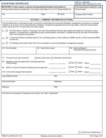
19 This is the Traditional DFIRM. Which is easier to use? Caution: Always Check DFIRM. Digital product is not official map! Elevation Certificates The Elevation Certificate Administrative tool of the NFIP Policy rating Support of map revisions and amendments Certify building elevations Community compliance New E.C. just released, Expires 1/30/18, Not yet on Web. Download at: Elevation Certificate Contents Provides detailed, thorough instructions. Requests latitude and longitude. Includes a comprehensive FIRM information section. Provides building elevation information: Detailed building diagrams Multiple building elevations Lowest floor (former reference level) no longer required of the certifier (architect, engineer, surveyor) Measure Bottom Floor and Next Higher Floor Bottom Floor, Next Higher Floor, Lowest Adjacent Grade and Flood Vent Information are used to determine Lowest Floor

20 Elevation Certificate Questions Why is it important to establish BFEs? How does the Elevation Certificate assist the agent to rate a property? Who is qualified to certify elevations for most zones in the Special Flood Hazard Area? How does a surveyor or agent identify an SFHA? Do all buildings in the SFHA need an Elevation Certificate? Does the NFIP mandate using an Elevation Certificate to meet program requirements? Insurance Rating Pre-FIRM and Post-FIRM On or Before 12/31/74 or Before the Initial FIRM Date Pre After 12/31/74 and on or After the Initial FIRM Date Post How do you Find Pre-FIRM Date? FEMA Community Status Book Required for flood insurance rating of post FIRM and some pre FIRM buildings. Determine compliance with floodplain management ordinance. Support map revisions and amendments. Prerequisite for the Community Rating System. 119 When is an Elevation Certificate Required for Insurance Rating? Zones B, C & X: Not in Special Flood Hazard Area (SFHA) No elevation certificate needed Post-FIRM Construction in SFHA Zones Elevation certificate is required Pre-FIRM Construction in SFHA Zones Needed for optional elevation rating Beginning in 2013: Elevation certificate are needed for some pre-firm policies Will eventually be needed for All pre-firm policies in SFHA Current Version: FEMA Form (7/12) Mandatory for use after August 1, 2013 July 31, 2015 expiration date Federal Forms Often Live Past Expiration Date Download from New E.C. at html Fillable PDF and Word Versions New E.C. has been approved; Not on regular FEMA site yet. Will be required as of


21
 have no")
22 Elevation Certificate Checklist Section A: Property Information Lat/Long: Can use Google Earth A7: Bldg Diagram Number: We ll Go Over A8: Vent Openings: One Key to Compliance and Insurance Rating A9: Attached Garage Permanent Flood Openings 129 Flood Opening 130 Standard is 1 square inch net opening per square foot of enclosed floor space If the crawlspace or enclosure(s) have no permanent flood openings, or if the openings are not within 1.0 foot above adjacent grade, enter 0 (zero) in Items A8.b c. Flood Opening 131 Engineered Flood Openings 132 Allowed Can Have Less Net Opening Must Include Documentation If applicable, attach a copy of the Individual Engineered Flood Openings Certification or an Evaluation Report issued by the International Code Council Evaluation Service (ICC ES) 22


23 Engineered Flood Openings Section B: Community, Map and BFE Info Panel Number: May Be Different from Community Number Index Date May Differ from Panel Date BFE: Use Flood Insurance Study CBRS / OPA? Map Panel and Map Index Date May Not Be the Same Map Panel Information Cobleskill, Town Of, C153 E 2/16/2012 4/2/2004 Schoharie NY CBRS Zones and Otherwise Protected Areas Coastal Barrier Resources System: Enacted by Congress Maintained by Fish and Wildlife Service Shown on FIRMs No Flood Insurance for New or Substantially Improved Structures after Designation of Zone 137 Section C: Bldg Elevation Information Survey Required Every time If >1 Floor V Zone Only If Attached Garage Always Always Always If Deck or Stairs


24 Building Diagram Number: A7 C1: Proposed or Finished Construction? C2: All of the Relevant Ground and Building Elevations Building Diagrams 141 Building Diagrams Building Diagram Number 1B Raised Slab or Foundation with Fill 2015 E.C. divides Diagram 1 into slab on grade (1B) and Raised slab on grade or slab on stem wall with fill. Same rules apply. 24


25 Slab-on-grade, one story building with attached garage 145 Diagram 2A: Basement A floor that is below grade on all sides is considered a basement. 146 New Diagram 2B 147 Multiple-floor building with basement 148 2A is the same as 2 in old E.C. 2B: Below Ground Level Egress. One story building with Basement


26 Slab-on-grade, split-level building Split-level building without attached garage Elevated Buildings Pilings Posts Piers Parallel Sheer Walls 155 Manufactured home elevated on pier foundation


27 Enclosure That Portion of an Elevated Building Below the Lowest Elevated Floor that is Either Partially or Fully Shut in by Rigid Walls Use a little design sense here! 27


28 Building elevated on full-story foundation walls with a fully enclosed area below the elevated floor 163 Building elevated on full-story foundation walls with garage below the elevated floor 164 A One-story building on crawl space with attached garage A8 Multi-level building elevated on crawl space Not Compliant in NYS A8 28


29 What diagram? 169 What diagram? What diagram? What diagram? What diagram? 173 What diagram?


30 What diagram? 175 What diagram? What diagram? What diagram? What diagram? What diagram? 30


31 What diagram? What diagram? What diagram? What diagram? What diagram? What diagram? 31

32 Machinery and/or Equipment Furnaces Hot water heaters Heat pumps Air conditioners Elevators and their equipment Map Changes Letters of Map Change For Elevation Based Determinations To Fine Tune the Determination To Show Changes to the Floodplain or Flood Elevation Types of Letters of Map Change Letter of Map Amendment Letter of Map Revision Letter of Map Revision Based on Fill Physical Map Revision (Revised Map) Amendments Used to exclude individual structures and legally described parcels of undeveloped land inadvertently included in the SFHA Based on conditions prior to map date Does NOT require review and approval of community Does NOT require update of Maps or Regulations Revisions Changes to Maps to reflect better flood and non-flood information Changes in floodplain conditions Increased/Decreased flood heights Longer period of record Development pressures Requires Community review and approval May require update of maps and regulations 32
33 LOMA Form MT-EZ Single Residential Lot or Structure Community and Property Information Date and Type of Construction Recorders Stamped Subdivision Plat/Deed FIRM & Cover with Site & Structures Plotted Elevation Certificate or Elevation Information Form LOMA s Based on Natural Ground Elevations File with FEMA; Address on Form No Charge for LOMA Review If Approximate A zone, fill out LAG but leave BFE blank. In some cases DEC can help determine an approximate BFE LOMR-F Form MT-1 Single Structures on Fill Include same Information as LOMA PLUS Community Acknowledgement Form LOMR-F Fees, 2016 $425, single lot/structure $800, multiple lot/structure LOMA and LOMR-F Basis of Determination For LOMA: Comparison of BFE to Elevation of the Lowest Adjacent Grade to the Structure including attached decks. For LOMR-F: Same as LOMA plus Comparison of BFE to Lowest Floor. IF ELEVATED but any portion of the Structure below BFE the building will NOT be removed from SFHA Surveyor s or Engineer s Role Surveyors do not Determine Compliance. Surveyor Data is used to Determine Compliance. Surveyor Data used to Determine Accurate Flood Insurance Ratings. Just the Facts! flood insurance program/national floodinsurance program forms 33
 Series of 12 forms to request a LOMR Forms to Use Depends on Nature of LOMR Community endorsement of the map change process is very")
34 Map Change Request Forms Map Change Process MT-EZ: MT-1: MT-2: Single lot/existing structure, no fill, no change to BFE or floodway (LOMA) Single or multiple lots/structures, proposed structures or fill, no change to BFE (LOMA, CLOMA, LOMR-F, CLOMR-F) Series of 12 forms to request a LOMR Forms to Use Depends on Nature of LOMR Community endorsement of the map change process is very important. For any map change letter other than a LOMA, a local official must sign the request Map Change Letters From FEMA Type of LOMC Form Used Filled Out By Fee (2017) LOMA MT 1 or MT EZ Surveyor None Single Lot MT 1 Surveyor $500 $600 CLOMR F Single Lot LOMR F Multiple Lot CLOMR F or LOMR F MT 1 Surveyor $425 $525 MT 1 Surveyor $800 $900 CLOMR MT 2 Engineer $6500 $7250 LOMR MT 2 Engineer $8000 $9250 Map Change Letters From FEMA Who receives the map change letter from FEMA? Applicant, Local Community, State What is the difference between a LOMR and a LOMR-F? LOMR is a physical change to part of a flood map. Incudes a revised mapped area. LOMR-F does not result in a new map but does exclude a defined parcel or portion of it from the Special Flood Hazard area Hourly Review Fees can Increase the Cost for LOMR s and CLOMR s Structure Site Situation 1: What LOMC Applies? BFE 34


35 Situation 2: What LOMC Applies? Situation 3: What LOMC Applies? BFE BFE Failure To Request Map Changes Real Case: August s Subdivision; 2010s Complaints Remember... LOMA and LOMR-F applications require detailed methods of determining BFEs and Lowest Adjacent Grade 35

36 LOMAs Community Concurrence or Permit Not Needed Letters sent to Applicant, Municipality, State Existing LOMC s Available Online at Map Service Center LOMA: MT-EZ Available in Fillable MS-Word Format Removes Entire Property, Portion of Property, or Just the Parcel from the Special Flood Hazard Area Comparison of Lowest Adjacent Grade, or low point on Parcel or Portion of Parcel to BFE LOMA Out As Shown Use if Structure is Clearly Outside of SFHA on Map Survey Not Required; Property Owner Can Fill Out LOMA Out as Shown Use MT-EZ Form Items to Include Deed Map of Property and Structure with SFHA Boundaries Shown Check with Municipal or County GIS or with DEC FIRMette DEC has Detailed Guidance LOMR-F s: Use MT-1 Includes Same Information as LOMA PLUS Community Acknowledgment Form Fee to File Cannot Be Used if Existing Structure has Lowest Floor, Including Basement, Below BFE Requires Proper Placement of Fill What is Fill? Material from Any Source placed that raises the ground to or above the BFE. Removal of Material and Backfilling is not Considered to be Fill Fill placed Prior to Date of First FIRM is considered to be natural grade. 36


37 LOMR-F Removes Parcel or Portion of Parcel from SFHA Based on Elevation of Properly Compacted Fill Fill must have been Permitted by Community If Land Elevated but Any Portion of Structure is Below BFE, Building will not be Removed from SFHA Cross-Sectional View of a LOMR-F Request Pre-Construction: Get LOMR-F After Receive LOMR-F, Construction May Proceed with Lowest Floor Below Deck Support in SFHA can bring entire structure into flood zone! BFE Some Communities May Not Approve In this example, LOMR-F would be refused if post construction CFR 65.2(c) From Technical Bulletin 10-1 Reasonably safe from flooding means base flood waters will not inundate the land or damage structures to be removed from the SFHA and that any subsurface waters related to the base flood will not damage existing or proposed buildings MT-1 Forms Multiple Lot or Property LOMA LOMR-F Includes: Property Information Form Elevation Form Community Acknowledgment Form For LOMR-F (Final or Conditional) Payment Information Form 37


38 Documents to Include Effective FIRM Panel Plat or Deed Elevation Form (Form 2 of MT-1) Community Acknowledgment form if LOMR F or CLOMR-F For CLOMR-F FEMA requires Endangered Species Act Compliance Documentation Community Acknowledgment Form Community Official Affirms: Received and Reviewed Meets Community Floodplain Mgmnt Req s No Fill in Floodway All Permits Received or Will Be Obtained Endangered Species Act Compliance Land and Structures Reasonably Safe from Flooding Community Acknowledgment Inadvertently In Floodway Sometimes Property can get LOMA based on Natural Grade but is in Floodway Floodway Boundaries are Generalized Between Cross Sections Community asked to Acknowledge if This is the Case LOMR: MT-2 For Physical Map Changes May Be Map Update Projects which Change Floodplain LOMR Forms Overview and Concurrence (All Use) Riverine Hydrology and Hydraulics Riverine Structures Coastal Analysis Coastal Structures Alluvial Fan Flooding Payment Information (All Use) 38
39 LOMRs Fee Exempt if Correcting Map Error based on Natural Conditions or Providing More Detailed Map Data (e.g.: Approximate A to AE) New Laws Exempt Fees for LOMR s Based on a Habitat Restoration Project with Some Federal or State Funds, Including Dam Removals Usually Takes Months Detailed Engineering Required More on LOMRs Physically Changes FIRM and possibly Flood Insurance Study Local Community must Adopt Changes into its Local Law There is an Appeal Process 231 Thank You William Nechamen, CFM Chief, Floodplain Management Section NYS DEC 625 Broadway, 4 th Floor Albany, NY william.nechamen@dec.ny.gov Connect with us: Facebook: Twitter: twitter.com/nysdec Flickr: 39
Floodplain Management 101. Mississippi Emergency Management Agency Floodplain Management Bureau
 Floodplain Management 101 Mississippi Emergency Management Agency Floodplain Management Bureau Stafford Act The Stafford Disaster Relief and Emergency Assistance Act (Stafford Act) (Public Law 100-707)
NFIP Mapping Issues. Wendy Lathrop, PLS, CFM. Cadastral Consulting, LLC
 NFIP Mapping Issues Cadastral Consulting, LLC NFIP Basic Objectives: Reduce the exposure to flood damages through the use of minimum standards for the placement and design of structures located in flood
National Flood Insurance Program (NFIP) for Real Estate Professionals
 for Real Estate Professionals") National Flood Insurance Program (NFIP) for Real Estate Professionals 1 Joshua Oyer, CFM Outreach Specialist NFIP State Coordinator s Office at the Texas Water Development Board 2 Outline Introduction
National Flood Insurance Program (NFIP) for Real Estate Professionals 1 Joshua Oyer, CFM Outreach Specialist NFIP State Coordinator s Office at the Texas Water Development Board 2 Outline Introduction
DEC Floodplain Coordinators Central Office Main Number: DEC NFIP Regional Coordinators
 National Flood Insurance Program: Information for Surveyors The New York State Department of Environmental Conservation Division of Water Bureau of Flood Protection and Dam Safety DEC Floodplain Coordinators
National Flood Insurance Program
 National Flood Insurance Program FEMA ELEVATION CERTIFICATES PA Surveyor Training Presented by Thomas F. Smith, PE, PLS January 22, 2018 1 FEMA Region III Mitigation Division Floodplain Management & Insurance
Role of the Local Floodplain Administrator
 2/22/2016 Role of the Local Floodplain Administrator Marsha Hilmes-Robinson Floodplain Administrator City of Fort Collins, Colorado mhilmesrobinson@fcgov.com 1 Partnership Engineer/Architect/ Contractor
Post Disaster Floodplain Administrator Response 2 Hours
 Post Disaster Floodplain Administrator Response 2 Hours 1 "We knew there had been floods, but water had never gotten into the house." That's what happened in January 1996, when one of the worst floods
FEMA Elevation Certificates and Hydrostatic Venting Requirements
 FEMA Elevation Certificates and Hydrostatic Venting Requirements Tennessee Association of Floodplain Managers Conference Gatlinburg, TN July 30 August 2, 2013 1 What is the National Flood Insurance Program
Kevin Wagner Maryland Department of the Environment
 Kevin Wagner Maryland Department of the Environment Topics Overview of the National Flood Insurance Program (NFIP) Mapping Regulations Insurance Mitigation Community Rating System (CRS) Questions Know
Enough about me! Topics Covered
 About Me Worked in land surveying since 1997 Employed by the City of Orlando since 2006 City of Orlando City Surveyor since February 2015 Certified Floodplain Manager since 2015 Florida Licensed Surveyor,
NFIP Overview Elevation Certificate Flood Insurance Rate Maps. By: Maureen O Shea, AICP, CFM State NFIP Coordinator
 NFIP Overview Elevation Certificate Flood Insurance Rate Maps By: Maureen O Shea, AICP, CFM State NFIP Coordinator Example of a flood failure Example of a flood failure Purposes of the NFIP Identify &
MOKAN CRS Users Group Activity 310, Elevation Certificates Packet
 http://mokan.stormsmart.org/ MOKAN CRS Users Group Activity 310, Elevation Certificates Packet This packet includes the following documents to be used as applicable to your community: EC checklist EC correction
JAXGIS FEMA Flood Hazard Mapping -- Frequently Asked Questions
 Flood Hazard Zone Designations Summary Zones starting with the letter 'A' (for instance, Zone A, Zone AE, Zone AH, Zone AO) denote a Special Flood Hazard Area, which can also be thought of as the 100-year
Revisions to National Flood Insurance Program Maps
 MT-1 Revisions to National Flood Insurance Program Maps Application Forms and Instructions for Conditional and Final Letters of Map Amendment and Letters of Map Revision Based on Fill FEMA Form 81-87 Series
FLOODPLAIN FAQ s. Last Update: June 2017
 FLOODPLAIN FAQ s Last Update: June 2017 What does FEMA stand for? Federal Emergency Management Agency - the operation of FEMA is to lead America to prepare for, prevent, respond to, and recover from disasters.
Floodplain Management 101: UNIT II. Maps & Flood Insurance Studies
 Floodplain Management 101: UNIT II Maps & Flood Insurance Studies Who is ASFPM? ASFPM stands for the Association of State Floodplain Managers A national organization of floodplain management professionals
INSTRUCTIONS FOR COMPLETING THE APPLICATION FORMS FOR CONDITIONAL LETTERS OF MAP REVISION AND LETTERS OF MAP REVISION
 INSTRUCTIONS FOR COMPLETING THE APPLICATION FORMS FOR CONDITIONAL LETTERS OF MAP REVISION AND LETTERS OF MAP REVISION GENERAL In 1968, the U.S. Congress passed the National Flood Insurance Act, which created
Article 23-6 FLOODPLAIN DISTRICT
 AMENDING THE CODE OF THE CITY OF PITTSFIELD CHAPTER 23, ZONING ORDINANCE SECTION I That the Code of the City of Pittsfield, Chapter 23, Article 23-6 Floodplain District, shall be replaced with the following:
THE FEDERAL EMERGENCY MANAGEMENT AGENCY. Letters of Map Change Kristen Martinenza, P.E., CFM FEMA Region IV
 THE FEDERAL EMERGENCY MANAGEMENT AGENCY Letters of Map Change Presented by: Kristen Martinenza, P.E., CFM FEMA Region IV 1 NATIONAL FLOOD INSURANCE ACT OF 1968 At the start of the program, there was not
Pinellas County Flood Map Information Service & Real Estate Disclosure Program Training January 26, 2017 COMMON FLOODPLAIN ACRONYMS
 FEMA ASFPM BFE CAV Pinellas County Flood Map Information Service & Real Estate Disclosure Program Training COMMON FLOODPLAIN ACRONYMS Federal Emergency Management Agency Association of State Floodplain
Now forget it all for the next 90 minutes.
 Karol L. Grove, PS Get ready to think outside of the box. Get ready to think about surveying, flood zones and flood insurance in a whole new light.. Think about everything you think you know about Elevation
Table 1: Federal, State and Local Government Rules applicable to LOMRs/CLOMRS submittal
 MnDNR LOMC Guide This document has been prepared by the Minnesota Department of Natural Resources floodplain staff and is intended to provide assistance with LOMR/CLOMR submittals. This information is
Door County Floodplain Program Informational Meeting
 Door County Floodplain Program Informational Meeting Door County Land Use Services Department Wisconsin Department of Natural Resources January 15, 2018 Floodplain = Land affected by flood event with a
Mistakes on Elevation Certificates
 Mistakes on Elevation Certificates What is the Base Flood Elevation (BFE) & how do you determine it? FIRM Map Panel? Flood Insurance Study? o Profile Sheet o Floodway Data Chart o Stillwater Chart Community
Introduction to the National Flood Insurance Program: A Guide for Coastal Property Owners MAINE BEACHES CONFERENCE 2017
 Introduction to the National Flood Insurance Program: A Guide for Coastal Property Owners MAINE BEACHES CONFERENCE 2017 SUE BAKER, CFM STATE NFIP COORDINATOR MAINE DEPT OF AGRICULTURE, CONSERVATION & FORESTRY
FREQUENTLY ASKED QUESTION ABOUT FLOODPLAINS Michigan Department of Environmental Quality
 FREQUENTLY ASKED QUESTION ABOUT FLOODPLAINS Michigan Department of Environmental Quality WHAT IS A FLOOD? The National Flood Insurance Program defines a flood as a general and temporary condition of partial
Federal Emergency Management Agency
 Page 1 of 3 COMMUNITY AND MAP PANEL INFORMATION COMMUNITY CITY OF MARGATE CITY, ATLANTIC COUNTY, NEW JERSEY LEGAL PROPERTY DESCRIPTION A parcel of land, as described in Deed recorded in Book 4826, page
Appendix D - Floodplain Documents
 City of Aspen Urban Runoff Management Plan Appendix D - Floodplain Documents 1. Floodplain Development Permit 2. Elevation Certificate and Instructions 3. Floodproofing Certificate for Non-Residential
CHAPTER 4. REGULATIONS AND DEVELOPMENT STANDARDS
 CHAPTER 4. REGULATIONS AND DEVELOPMENT STANDARDS Regulations and development standards, which can be used by communities to reduce damage from natural hazards, work best when using an effective planning
SECTION 9: MAPS AND DATA
 SECTION 9: MAPS AND DATA Contents 9.1. NFIP Maps and Data... 9-2 9.1.1. Adopting and enforcing NFIP floodplain maps and data... 9-2 9.1.2. Adopting and enforcing more restrictive data... 9-2 9.1.3. Annexations...
TOWN OF KENT, CT PLANNING AND ZONING COMMISSION
 TOWN OF KENT, CT PLANNING AND ZONING COMMISSION FLOOD PLAIN MANAGEMENT REGULATIONS Whereas, Congress has determined that a National Flood Insurance Program would alleviate personal hardships and economic
Maryland Model Floodplain Management Ordinance (May, 2014) MODEL NOTES
 MODEL NOTES") Maryland Model Floodplain Management Ordinance (May, 2014) MODEL NOTES The model floodplain management ordinance that most Maryland communities have used as the basis for their regulations since the early
Maryland Model Floodplain Management Ordinance (May, 2014) MODEL NOTES The model floodplain management ordinance that most Maryland communities have used as the basis for their regulations since the early
YOLO COUNTY FLOODPLAIN MANAGEMENT PROGRAM
 YOLO COUNTY FLOODPLAIN MANAGEMENT PROGRAM Answers to Commonly Asked Questions and A Guide for Residential Construction Within Special Flood Hazard Areas The automatic entry and exit of flood water); Or
MT-1 Basics: A Comprehensive Overview of LOMAs and Discussion of Common Application Setbacks
 MT-1 Basics: A Comprehensive Overview of LOMAs and Discussion of Common Application Setbacks Introduction: Terminology MT-1s vs. MT-2s LOMAs vs. LOMRs What is a LOMC? Letters of Map Change (LOMCs) MT-1s
COLLIER COUNTY FLOODPLAIN MANAGEMENT
 COLLIER COUNTY FLOODPLAIN MANAGEMENT FREQUENTLY ASKED QUESTIONS The following information is based on common questions from the public. If you have a specific question or need further information, please
Updates to Maine Coastal Flood Insurance Rate Maps (FIRM s): What a Local Official Should Know. Presented by: Steve Johnson, P.E.
: What a Local Official Should Know. Presented by: Steve Johnson, P.E.") Updates to Maine Coastal Flood Insurance Rate Maps (FIRM s): What a Local Official Should Know Presented by: Steve Johnson, P.E. Town Engineer October 4, 2018 Introduction Federal Emergency Management
Updates to Maine Coastal Flood Insurance Rate Maps (FIRM s): What a Local Official Should Know Presented by: Steve Johnson, P.E. Town Engineer October 4, 2018 Introduction Federal Emergency Management
FLOOD INSURANCE. Introduction
 FLOOD INSURANCE Introduction The purpose of this course is to provide a comprehensive description of the NFIP for insurance producers who are seeking continuing education credits. It provides an overview
Kentucky Division of Water Permitting Floodplain Overview and Considerations
 Kentucky Division of Water Permitting Floodplain Overview and Considerations Presentation to: 2014 KAMM Conference Lake Barkley State Resort Park by Solitha Dharman Department for Environmental Protection
Florida Division of Emergency Management
 2017 FLOODPLAIN MANAGEMENT IN FLORIDA Florida Division of Emergency Management Bureau of Mitigation State Floodplain Management Office 2555 Shumard Oak Boulevard, Tallahassee, FL 32399 www.floridadisaster.org/mitigation
Chapter 6 - Floodplains
 Chapter 6 - Floodplains 6.1 Overview The goal of floodplain management is to reduce the potential risks to both existing and future developments, and infrastructure, in the 100-year floodplain. Over the
Floodplain Development Permit Application
 Floodplain Development Permit Application City of Jonesboro, AR This is an application packet for a Floodplain Development Permit. Certain sections are to be completed by the Applicant, and certain sections
CONTRA COSTA COUNTY FLOODPLAIN MANAGEMENT PROGRAM
 CONTRA COSTA COUNTY FLOODPLAIN MANAGEMENT PROGRAM Answers to Commonly Asked Questions and A Guide for Residential Construction Within Special Flood Hazard Areas Revised February 2015 Introduction Ninety
Requirements for Construction on Properties in the Special Flood Hazard Area (SFHA)
") Requirements for Construction on Properties in the Special Flood Hazard Area (SFHA) Rev 010915 The website for the IDNR to request the EFARA (Electronic Floodplain Analysis/Regulatory Assessment is found
Requirements for Construction on Properties in the Special Flood Hazard Area (SFHA) Rev 010915 The website for the IDNR to request the EFARA (Electronic Floodplain Analysis/Regulatory Assessment is found
a) Ensure public safety through reducing the threats to life and personal injury.
 Ensure public safety through reducing the threats to life and personal injury.") SECTION VII: FLOODPLAIN DISTRICT 7-1 Statement Of Purpose The purposes of the Floodplain District are to: a) Ensure public safety through reducing the threats to life and personal injury. b) Eliminate
SECTION VII: FLOODPLAIN DISTRICT 7-1 Statement Of Purpose The purposes of the Floodplain District are to: a) Ensure public safety through reducing the threats to life and personal injury. b) Eliminate
National Institute of Building Sciences
 National Institute of Building Sciences Provider Number: G168 Improving the Flood Resistance of Buildings and Mitigation Techniques WE3B Peter Spanos, P.E., CFM, LEED AP (Gale Associates, Inc.) Stuart
REGION X FLOOD DAMAGE PREVENTION ORDINANCE WASHINGTON MODEL (REVISED 5/13/2004)
") REGION X FLOOD DAMAGE PREVENTION ORDINANCE WASHINGTON MODEL (REVISED 5/13/2004) Close to 300 towns, cities, counties, and tribes within the State of Washington participate in the National Flood Insurance
REGION X FLOOD DAMAGE PREVENTION ORDINANCE WASHINGTON MODEL (REVISED 5/13/2004) Close to 300 towns, cities, counties, and tribes within the State of Washington participate in the National Flood Insurance
ATTACHMENT A SUMMARY OF THE NFIP OCTOBER 2013 PREMIUM RATE AND RULE CHANGES
 ATTACHMENT A SUMMARY OF THE NFIP OCTOBER 2013 PREMIUM RATE AND RULE CHANGES National Flood Insurance Program October 1, 2013, Premium Rate and Rule Changes: A Summary 1. Premium Increases Premiums will
ATTACHMENT 1. Amendments to Chapter 18.20, Definitions Area of shallow flooding Area of special flood hazard
 Amendments to Chapter 18.20, Definitions 18.20.206 Area of shallow flooding Area of shallow flooding means a designated AO, or AH, AR/AO, AR/AH, or VO Zone on the a community's flood insurance rate map
WOOD COUNTY, WV FLOODPLAIN ORDINANCE TABLE OF CONTENTS
 WOOD COUNTY, WV FLOODPLAIN ORDINANCE TABLE OF CONTENTS ARTICLE I - GENERAL PROVISIONS 3 Section 1.1 Intent 3 Section 1.2 Abrogation and Greater Restrictions 3 Section 1.3 Applicability 3 Section 1.4 Matters
TOWN OF TUNBRIDGE FLOOD HAZARD AREA ORDINANCE March 18, UPDATE June 17, 2014
 TOWN OF TUNBRIDGE FLOOD HAZARD AREA ORDINANCE March 18,1998 - UPDATE June 17, 2014 1.0 STATUTORY AUTHORIZATION 1.1 To effect the purposes of 10 V.S.A., Chapter 32, and in accord with the Vermont Planning
F L F fl OOO O573. ?5JN 8 HI!:62 OF CRCJi GJh DORCHESTER COUNTY, MARYLANDORCHFSiER county
 OOO O573 COUNTY COUNCIL F L F fl?5jn 8 HI!:62 OF CRCJi GJh DORCHESTER COUNTY, MARYLANDORCHFSiER county 2015 Legislative Session, Legislative Day No. 1, 2015 Introduced by: County Council Bill No. 2015-1
Flood Map Revisions. Town of Nags Head Public Information and Input Session. December 14, 2016, 6 pm
 Flood Map Revisions Town of Nags Head Public Information and Input Session December 14, 2016, 6 pm Flood Map Revisions New preliminary flood maps released for Dare County June 30, 2016 www.nagsheadnc.gov/floodmaps
Oak Island 1999 Hurricane Floyd
 Oak Island 1999 Hurricane Floyd Topics to be Discussed What is a flood zone Flood zones in Oak Island Special Flood Hazard Areas (SFHA) Flood insurance Base Flood Elevations (BFEs) Building in flood zones
SPECIAL CERTIFICATIONS
 SPECIAL CERTIFICATIONS This section presents detailed instructions for the completion of the National Flood Insurance Program (NFIP) Elevation Certificate (EC) and the NFIP Floodproofing Certificates.
WAYNE COUNTY COMMUNITY CONSULTATION OFFICERS (CCO) MEETING. February 27, 2019
 MEETING. February 27, 2019") WAYNE COUNTY COMMUNITY CONSULTATION OFFICERS (CCO) MEETING February 27, 2019 TODAY S AGENDA Review the Updated Flood Risk Data for Your County Next Steps in the Map Adoption Process Understanding Flood
WAYNE COUNTY COMMUNITY CONSULTATION OFFICERS (CCO) MEETING February 27, 2019 TODAY S AGENDA Review the Updated Flood Risk Data for Your County Next Steps in the Map Adoption Process Understanding Flood
Cameron County, TX. Consultation Coordination Officer (CCO) Meeting. Please sign in (sheet at front of the room) Meeting will begin at 9:00
 Meeting. Please sign in (sheet at front of the room) Meeting will begin at 9:00") Cameron County, TX Consultation Coordination Officer (CCO) Meeting Please sign in (sheet at front of the room) Meeting will begin at 9:00 July 29, 2015 Lisa Jennings FEMA Region 6 Roles & Responsibilities
Cameron County, TX Consultation Coordination Officer (CCO) Meeting Please sign in (sheet at front of the room) Meeting will begin at 9:00 July 29, 2015 Lisa Jennings FEMA Region 6 Roles & Responsibilities
W October 1, Write Your Own (WYO) Principal Coordinators and the National Flood Insurance Program (NFIP) Servicing Agent
 Principal Coordinators and the National Flood Insurance Program (NFIP) Servicing Agent") U.S. Department of Homeland Security 500 C St. SW Washington, D.C. 20472 W-14053 October 1, 2014 MEMORANDUM FOR: Write Your Own (WYO) Principal Coordinators and the National Flood Insurance Program (NFIP)
U.S. Department of Homeland Security 500 C St. SW Washington, D.C. 20472 W-14053 October 1, 2014 MEMORANDUM FOR: Write Your Own (WYO) Principal Coordinators and the National Flood Insurance Program (NFIP)
Chapter 5 Floodplain Management
 Chapter 5 Floodplain Management Contents 1.0 Introduction... 1 2.0 Floodplain Management and Regulation... 1 2.1 City Code... 1 2.2 Floodplain Management... 1 2.3 Level of Flood Protection... 2 2.3.1 Standard
17.13 FLOOD DAMAGE PREVENTION ORDINANCE. Article I. Statutory Authorization, Findings of Fact, Purpose, and Methods
 17.13 FLOOD DAMAGE PREVENTION ORDINANCE Article I Statutory Authorization, Findings of Fact, Purpose, and Methods 17.1301 Statutory Authorization. The Legislature of the State of South Dakota has in (statutes)
2011 FLOODPLAIN MANAGEMENT ORDINANCE FOR LINCOLN COUNTY
 2011 FLOODPLAIN MANAGEMENT ORDINANCE FOR LINCOLN COUNTY First Reading: September 13, 2011 Second Reading: September 27, 2011 Publication Date: October 6, 2011 and October 13, 2011 Effective Date: November
Preliminary DFIRM Community Coordination (PDCC) Meeting Gilchrist & Levy Counties, FL. April 30, 2015
 Meeting Gilchrist & Levy Counties, FL. April 30, 2015") Preliminary DFIRM Community Coordination (PDCC) Meeting Gilchrist & Levy Counties, FL April 30, 2015 Agenda 1. Introductions 2. Study Process and Timeline 3. Overview of Preliminary Products 4. Overview
Preliminary DFIRM Community Coordination (PDCC) Meeting Gilchrist & Levy Counties, FL April 30, 2015 Agenda 1. Introductions 2. Study Process and Timeline 3. Overview of Preliminary Products 4. Overview
Durham County Preliminary Flood Hazard Data Public Meeting. July 28, 2016
 Durham County Preliminary Flood Hazard Data Public Meeting July 28, 2016 Why Are We Here New flood hazard data has been released as Preliminary for Durham County Statutory Due Process for review/comments
Abington Township Public Meeting
 Abington Township Public Meeting Flood Insurance Rate Map Update March 23, 2016 1 Meeting Agenda and Format Provide residents/property owners of Abington Township with information about the map update,
WHEREAS, the base flood elevation set forth within Ordinance No. 351 was intended in all instances to be 18 inches and not two feet ; and,
 ORDINANCE NO. 353 OF THE CITY OF BUCKHANNON, AN ORDINANCE: (1) ESTABLISHING A FLOODPLAIN AREA AND REQUIRING ALL CONTRACTORS, PERSONS, PARTNERSHIPS, BUSINESSES, AND CORPORATIONS TO OBTAIN A PERMIT FOR THE
Dealing With Unnumbered A Zones in Maine Floodplain Management
 Dealing With Unnumbered A Zones in Maine Floodplain Management The following is a list of acceptable methods that the State Floodplain Management Coordinator and the Federal Emergency Management Agency
1. STATUTORY AUTHORIZATION, FINDINGS OF FACT, AND PURPOSES... 2
 ORDINANCE NO. 15-03 CAPE GIRARDEAU COUNTY FLOODPLAIN MANAGEMENT ORDINANCE ARTICLE # PAGE # 1. STATUTORY AUTHORIZATION, FINDINGS OF FACT, AND PURPOSES... 2 2. GENERAL PROVISIONS... 3 3. ADMINISTRATION...
Federal Emergency Management Agency
 Page 1 of 5 Issue Date: July 27, 2012 Effective Date: December 10, 2012 Case No.: 11-06-4512P Follows Conditional Case No.: 06-06-B789R LOMR-APP Federal Emergency Management Agency Washington, D.C. 20472
NFIP Program Basics. KAMM Regional Training
 NFIP Program Basics KAMM Regional Training Floodplain 101 Homeowners insurance does not cover flood damage Approximately 25,000 flood insurance policies in KY According to BW12 analysis, approximately
City of St. Augustine. Floodplain Management Higher Standards Information
 City of St. Augustine Floodplain Management Higher Standards Information There are different regulations that communities can use to help protect existing and future development and natural floodplain
ADVISORY BASE FLOOD ELEVATIONS (ABFEs)
") The Department of Homeland Security s Federal Emergency Management Agency is committed to helping communities that were impacted by Hurricanes Katrina and Rita rebuild safer and stronger. Following catastrophic
The Department of Homeland Security s Federal Emergency Management Agency is committed to helping communities that were impacted by Hurricanes Katrina and Rita rebuild safer and stronger. Following catastrophic
OTTAWA COUNTY AND SANDUSKY COUNTY COMMUNITY CONSULTATION OFFICERS (CCO) MEETING December 7, 2017
 MEETING December 7, 2017") OTTAWA COUNTY AND SANDUSKY COUNTY COMMUNITY CONSULTATION OFFICERS (CCO) MEETING December 7, 2017 TODAY S AGENDA The Value of Updated Flood Maps for Your Community Reviewing the Updated Flood Risk Data
OTTAWA COUNTY AND SANDUSKY COUNTY COMMUNITY CONSULTATION OFFICERS (CCO) MEETING December 7, 2017 TODAY S AGENDA The Value of Updated Flood Maps for Your Community Reviewing the Updated Flood Risk Data
Nassau County, Florida Consultation Coordination Officer (CCO) Meeting. February 24, 2016 Fernandina Beach, Florida
 Meeting. February 24, 2016 Fernandina Beach, Florida") Nassau County, Florida Consultation Coordination Officer (CCO) Meeting February 24, 2016 Fernandina Beach, Florida Agenda Introductions Coastal Study Update Study Process and Timeline Flood Insurance Implications
Nassau County, Florida Consultation Coordination Officer (CCO) Meeting February 24, 2016 Fernandina Beach, Florida Agenda Introductions Coastal Study Update Study Process and Timeline Flood Insurance Implications
Duval County, Florida Consultation Coordination Officer (CCO) Meeting. January 25, 2017 Jacksonville, Florida
 Meeting. January 25, 2017 Jacksonville, Florida") Duval County, Florida Consultation Coordination Officer (CCO) Meeting January 25, 2017 Jacksonville, Florida Agenda Introductions Coastal Study Update Study Process and Timeline Flood Insurance Implications
Duval County, Florida Consultation Coordination Officer (CCO) Meeting January 25, 2017 Jacksonville, Florida Agenda Introductions Coastal Study Update Study Process and Timeline Flood Insurance Implications
CHAPTER 8 FLOOD PREVENTION AND PROTECTION*
 CHAPTER 8 FLOOD PREVENTION AND PROTECTION* ---------- *Cross reference(s)--drainage commission, 2-111 et seq.; drainage districts created, 2-114; site drainage requirements for manufactured or mobile home
CRISP COUNTY, GEORGIA AND INCORPORATED AREAS
 CRISP COUNTY, GEORGIA AND INCORPORATED AREAS Community Name Community Number ARABI, CITY OF 130514 CORDELE, CITY OF 130214 CRISP COUNTY (UNINCORPORATED AREAS) 130504 Crisp County EFFECTIVE: SEPTEMBER 25,
ORDINANCE NO A FLOOD DAMAGE PREVENTION ORDINANCE
 ORDINANCE NO. 692-14 A FLOOD DAMAGE PREVENTION ORDINANCE WHEREAS, for a community to participate in the National Flood Insurance Program NFIP, it must adopt and enforce floodplain management regulations
Floodplain Development Permit Application
 Floodplain Development Permit Application **All construction will also require a building permit** This is an application packet for a Floodplain Development Permit. Certain sections are to be completed
Community Rating System. National Flood Insurance Program
 National Flood Insurance Program Community Rating System A Local Official s Guide to Saving Lives Preventing Property Damage Reducing the Cost of Flood Insurance FEMA B-573 / May 2015 How the Community
UPSHUR COUNTY FLOODPLAIN ORDINANCE
 UPSHUR COUNTY FLOODPLAIN ORDINANCE AN ORDINANCE ESTABLISHING A FLOODPLAIN AREA AS IDENTIFIED BY THE FEDRAL EMERGENCY MANAGEMENT AGENCY (FEMA); REQUIRING ALL CONTRACTORS, PERSONS, PARTNERSHIPS, BUSINESSES
LOCAL OFFICIALS MEETING Lake Wausau Physical Map Revision MARATHON COUNTY, WISCONSIN FEBRUARY 9, 2017
 LOCAL OFFICIALS MEETING Lake Wausau Physical Map Revision MARATHON COUNTY, WISCONSIN FEBRUARY 9, 2017 Welcome & Introduction Michelle Staff Floodplain Management Policy Coordinator, WDNR Michelle.Staff@Wisconsin.gov
A Floodplain Management District (FMD) is needed for the following reasons:
 is needed for the following reasons:") 703 FLOODPLAIN MANAGEMENT DISTRICT (FMD) 703.01 FINDINGS OF FACT A Floodplain Management District (FMD) is needed for the following reasons: A. Flood Losses Resulting from Periodic Inundation: The flood
703 FLOODPLAIN MANAGEMENT DISTRICT (FMD) 703.01 FINDINGS OF FACT A Floodplain Management District (FMD) is needed for the following reasons: A. Flood Losses Resulting from Periodic Inundation: The flood
Middlesex County Timeline
 Community Coordination Meeting for Middlesex County, Connecticut Risk MAP Study November 9, 2011 Agenda Welcome and Introductions Project Timeline Coastal Flood Hazard Analysis Recap Public Review and
Using GISWeb to Determine Your Property s Flood Zone
 Using GISWeb to Determine Your Property s Flood Zone 1. In a new browser window, go to http://www.co.santacruz.ca.us/departments/geographicinformationsystemsgis.aspx 2. Click on GISWeb - GIS Mapping Application
FLOOD DAMAGE PREVENTION REGULATION ARTICLE I STATUTORY AUTHORIZATION, FINDINGS OF FACT, PURPOSE AND OBJECTIVES
 CHAPTER 12 FLOOD DAMAGE PREVENTION REGULATION ARTICLE I STATUTORY AUTHORIZATION, FINDINGS OF FACT, PURPOSE AND OBJECTIVES SECTION A. STATUTORY AUTHORIZATION The Legislature of the State of Colorado has,
FLOOD DAMAGE PREVENTION RULES
 60.3(d) FLOOD DAMAGE PREVENTION RULES ARTICLE 1 STATUTORY AUTHORIZATION, FINDINGS OF FACT, PURPOSE AND METHODS SECTION A. STATUTORY AUTHORIZATION The Legislature of the State of Texas adopted the Flood
Chapter 415 FLOODPLAIN MANAGEMENT
 Chapter 415 FLOODPLAIN MANAGEMENT Editor's Note Ordinance no. A-7015 1, adopted December 27, 2000, enacted written administrative procedures for the floodplain management herein. Those written administrative
RIO ARRIBA COUNTY FLOOD DAMAGE PREVENTION ORDINANCE
 RIO ARRIBA COUNTY FLOOD DAMAGE PREVENTION ORDINANCE NO. 1982-1 RE VISED 1988-2 AMENDED 2008-01 RIO ARRIBA J. FRED VIGIl, COUNTY CLERK 200707904 Book 530 Page 7904 1 of 22 10/30/2007 O8:5Q ~~ AM BY 1 FLOOD
BERKELEY COUNTY FLOODPLAIN ORDINANCE
 . BERKELEY COUNTY FLOODPLAIN ORDINANCE i~ll :~~\I :-:~ ~( ~~< ~~:~ ----...r~i :-- \J.. '- ' t ~...~ '/ :.- f '. ~ ~ L ~._ ~~' w ~t i.~.~~~rt i l.- --.~. ' I ' e II... \... -'. ' '
Appendix B. A Comparison of the Minimum NFIP Requirements and the CRS
 A Comparison of the Minimum s and the CRS The Community Rating System provides credits for exceeding the minimum requirements of the National Flood Insurance Program (NFIP). Many local officials are not
Erie County Flood Risk Review Meeting. January 18, 2018
 Erie County Flood Risk Review Meeting January 18, 2018 Agenda The value of updated flood maps for your community Review updated flood-risk data and important next steps in the Risk MAP process Increasing
Michigan Department of Environmental Quality 525 West Allegan Street Lansing, MI (517)
") FLOODPLAIN MANAGEMENT IN MICHIGAN 2002 John Engler, Governor Russell J. Harding, Director Michigan Department of Environmental Quality 525 West Allegan Street Lansing, MI 48909 (517) 373-1170 www.michigan.gov/deq
FLOODPLAIN MANAGEMENT IN MICHIGAN 2002 John Engler, Governor Russell J. Harding, Director Michigan Department of Environmental Quality 525 West Allegan Street Lansing, MI 48909 (517) 373-1170 www.michigan.gov/deq
Flood Analysis Memo. 629 Orangewood Dr. Dunedin, FL BFE = 21 ft
 Flood Analysis Memo Property Address 629 Orangewood Dr. In Partnership with: ** This property is NOT within a high-risk flood zone ** 629 Orangewood Dr. BFE = 21 ft This property is located in the FEMA
Why do we care about floodplains?
 NFIP 101 Outline What is the NFIP? What are its goals? What is a flood? A floodplain? Maps, FIRMs, and FISs NFIP Requirements Local Flood Ordinances & Permitting Tips, Tricks, & Tools Mitigation & Other
Federal Emergency Management Agency
 Page 1 of 5 Issue Date: October 16, 2014 Effective Date: March 2, 2015 Case No.: 14-09-2279P LOMR-APP Federal Emergency Management Agency Washington, D.C. 20472 LETTER OF MAP REVISION DETERMINATION DOCUMENT
ORDINANCE NO. 2 Series 2013 TOWN OF PITKIN FLOODPLAIN DAMAGE PREVENTION ORDINANCE
 ORDINANCE NO. 2 Series 2013 TOWN OF PITKIN FLOODPLAIN DAMAGE PREVENTION ORDINANCE FLOOD DAMAGE PREVENTION ORDINANCE TABLE OF CONTENTS ARTICLE I - TITLE AND PURPOSE... 1 SECTION A. STATUTORY AUTHORIZATION...
A Continuing Education Correspondence Course for Land Surveyors, Engineers, and Floodplain Managers
 By: David Melvin, PLS, CFM Land Pro Seminars A Continuing Education Correspondence Course for Land Surveyors, Engineers, and Floodplain Managers (Examination materials, questions, and answer sheet are
11/18/2011. FEMA All rights reserved. FEMA All rights reserved. Session Overview
 3 Session Overview 4 1 Welcome to Session 2 of the FEMA NFIP Agent Training Program! Dorothy Martinez Rich Slevin Recall your learning from the previous session and share at least one important takeaway.
History of Floodplain Management in Ascension Parish
 History of Floodplain Management in Ascension Parish presented by: Kara Moree Floodplain Coordinator February 6, 2012 Floodplain 101 Floodplain 101 Base or 1% Flood: A flood having a 1% chance of being
SKOKOMISH RESERVATION FLOOD DAMAGE PREVENTION ORDINANCE TABLE OF CONTENTS
 TABLE OF CONTENTS STATUTORY AUTHORIZATION, FINDINGS OF FACT, PURPOSE, AND OBJECTIVES 6.04.001 Statutory Authorization 6.04.002 Findings of Fact 6.04.003 Statement of Purpose 6.04.004 Methods of Reducing
ASFPM Partnerships for Statewide Mitigation Actions. Alicia Williams GIS and HMP Section Manager, Amec Foster Wheeler June 2016
 ASFPM Partnerships for Statewide Mitigation Actions Alicia Williams GIS and HMP Section Manager, Amec Foster Wheeler June 2016 Summary The Concept Leveraging Existing Data and Partnerships to reduce risk