History of Floodplain Management in Ascension Parish
|
|
|
- Kristian Johns
- 6 years ago
- Views:
Transcription
1 History of Floodplain Management in Ascension Parish presented by: Kara Moree Floodplain Coordinator February 6, 2012
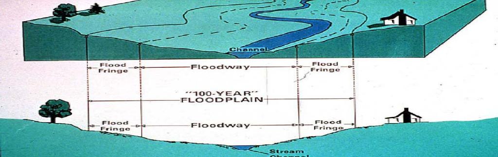
2 Floodplain 101
3 Floodplain 101 Base or 1% Flood: A flood having a 1% chance of being equaled or exceeded in any given year; also more commonly referred to as the 100 yr flood. Common misconception of 100 yr flood Does not mean that you will flood once every 100 years!!!
4 Floodplain 101 Base Flood Elevation (BFE): The height above sea level to which flood water would be expected to rise in a base, or 100 yr flood event.
 and a community Participating Communities agree to")
5 What is NFIP? Voluntary and mutual agreement between the Federal Emergency Management Agency (FEMA) and a community Participating Communities agree to adopt and administer appropriate regulations in return all of their residents are eligible for federally subsidized flood insurance.
6 History of NFIP 1968 NFIP established by Congress as part of the National Flood Insurance Act 1973 Flood Disaster Protection Act required all new and substantially improved buildings in identified flood hazard areas to have flood insurance as a condition of federal aid or loans from federally insured banks and as a condition for receiving federal disaster assistance (The 1973 Flood Disaster Protection Act prompted a large number of communities to participate in the NFIP)
7 History of NFIP (cont d) 1994 National Flood Insurance Reform Act: Authorized the Community Rating System Increased max. amount of flood insurance coverage Established a grant program for mitigation plans and projects Enacted stricter penalties on lenders to comply
8 What Happens if a Community Doesn t Participate in NFIP? NFIP flood insurance will not be available. No federal grants, loans, or mortgages for development may be made in identified flood hazard areas Makes financing a home extremely difficult and costly No federal disaster assistance may be provided to repair insurable buildings located in identified flood hazard areas for damage caused by a flood.
9 Ascension Parish and the NFIP 4/26/1973 entered into the Emergency Phase of NFIP with no flood map 12/12/1978 Flood Hazard Boundary Map (FHBM) issued 9/2/1981 entered into Regular Phase of NFIP and first effective Flood Insurance Rate Map (FIRM) issued 11/19/1992 Parish adopts Flood Damage Prevention Ordinance (minimum NFIP regulations) 4/15/1993 Parish adopts Building Codes Permitting 4/17/1997 Parish adopts 1 freeboard into the Flood Damage Prevention Ordinance
10 3 Basic Parts to NFIP Mapping Insurance Regulations
11 MAPPING
12 Ascension Flood Insurance Rate Maps (FIRM) 9/2/1981 First Effective FIRM issued 1/20/1993 Map Change 8/16/2007 Map Change (The 2007 Map Change was probably the most dramatic map change that the Parish has experienced to date. Many think that the 2007 FIRM s are a result of Hurricane Katrina. However, the Parish was already on schedule to have a map change well before this event in Katrina only delayed the maps from coming out sooner)
13 Ascension Flood Insurance Rate Maps (FIRM) Special Flood Hazard Areas (SFHA) = areas subject to flooding during the base flood event Ascension has 3 types of SFHA s depicted on the FIRMs. Zone A no BFEs determined Zones AE and AH BFEs determined
14 Ascension Flood Insurance Rate Maps (FIRM) Map changes are inevitable over time. As we are one of the fastest growing Parishes in the state, this means that not only is our population growing, but development is as well. Due to factors such as increased development and watershed changes over time, SFHAs and BFEs are likely to expand and increase.
15 INSURANCE
16 Flood Insurance Anyone living in a participating community can purchase flood insurance, whether their building is located in a SFHA or not. 2 types of structures considered: Pre FIRM constructed before the date of the initial FIRM of the community (Ascension Parish prior to 9/2/1981) Pre FIRM structures are treated and rated differently than structures built Post FIRM rates not actuarial Post FIRM rated based on how protected they are from the mapped hazard (ex. slab height in feet above or below BFE) Ascension Parish 9/2/1981 to present
17
18 Flood Insurance Stats Ascension Parish ( As of 8/31/2011) 8,930 Total Flood Insurance Policies includes policies both within and out of SFHA ~$5 million in premiums ~$2 billion in coverage 1,747 Pre FIRM policies 7,179 Post FIRM policies 238 Non Residential policies 8,692 Residential policies Source: FEMA and ISO
19 Insurance and Map Changes Grandfathering Grandfathering an old BFE 1. Which structures can benefit? Those built in compliance at the time of construction. 2. Use BFE that provides best rate 3. Provide your insurance agent (one of the following): Old map showing BFE Letter from community official Elevation Certificate
20 Insurance and Map Changes Grandfathering Grandfathering structures that were outside of the SFHA at the time of construction 1. Flood Insurance is still required 2. Grandfathering will provide a discount 3. Provide your insurance agent proof that structure was built to compliance Letter from community official Building permit records or date of construction FIRM in effect at time of construction
21 REGULATIONS
22 Flood Damage Prevention Ordinance Participating NFIP communities must use and adopt an ordinance that meets NFIP minimum requirements All proposed development in the designated floodplain shall require a permit Review permits to assure that sites are reasonably safe from flooding Requires that all new and substantially improved or damaged buildings be elevated or constructed to resist flood damages
23 Flood Damage Prevention Ordinance A community s floodplain management program and permit records are reviewed periodically by FEMA Community Assistance Visit (CAV) conducted every 5 years by FEMA and State NFIP Coordinator s office If a community is found to not be fully enforcing its Flood Ordinance, their participation in NFIP could be jeopardized Ascension s 5 yr. CAV was just conducted in Nov. 2011
24 Flood Damage Prevention Ordinance Communities are strongly encouraged to adopt and enforce regulations that exceed minimum NFIP requirements A couple of examples of higher standards: Requiring Freeboard Restrictions on amount of fill placed in SFHA There are certain perks that come along with adopting and enforcing regulations that exceed minimum requirements receiving credits in the Community Rating System is one of them!
25 Community Rating System (CRS) Voluntary program Participating communities can get credits for implementing certain activities above and beyond the minimum requirements of NFIP. Residents can get a certain percent reduction in their flood insurance premium rates based on the credits their community earns
26 Community Rating System Goal is to reduce flood losses, insurance ratings, and promote awareness of flood insurance Uses Class Rating System from 10 to 1 to determine % of flood insurance premium reduction for the community. Class 10 receives 0% reduction Class 1 receives maximum of 45% reduction Activity Categories: Public Information Mapping and Regulations Flood Damage Reduction Flood Preparedness
27 CRS Status in Ascension Currently rated as an 8 Residents receive automatic 10% discount on flood policies, which results in: Average Savings of $66 per policy Average Savings of $350,000 Parish wide If we were to achieve a rating of 7 Average Savings would be $99 per policy, and over $500,000 Parish wide 5 year Recertification Visit was conducted in Oct EBR Parish just achieved a Class 6 Rating St. Tammany Parish just achieved a 7
28 Freeboard An additional height requirement above BFE that provides a margin of safety against extraordinary or unknown risks Usually ranges from 1 to 3 feet (anything over 3 ft. above BFE is not counted for credits under CRS or towards insurance savings) Ascension Parish currently has a 1 foot of Freeboard in it s Flood Damage Prevention Ordinance (adopted 1997) A 1 Freeboard results in an average savings of 46% percent on a flood insurance policy, compared to a structure built at BFE
29
30 Benefits of Freeboard to Residents Dramatic savings on insurance premiums Being able to return to a safe and dry home after a base flood event Likely to still be at or above a new BFE if ever another map change occurs More likely to be eligible to apply for and receive a Letter of Map Amendment (LOMA) or Letter of Map Revision Based on Fill (LOMR F) from FEMA
31 Benefits of Freeboard to Ascension Parish Freeboard is about more than just receiving CRS credits! Enhanced public safety Reduction in damages to property and public infrastructure Avoidance of economic disruption and loss during a storm event Protects against non compliant structures which could jeopardize the Parish s participation in NFIP

32 Freeboard at its Best! This photo was taken about 10 years ago of a KFC in Baton Rouge that was built to freeboard.
33 Benefits of Freeboard Keep in mind that an event greater than a 100 yr storm can occur at any time and having freeboard is just a little bit of extra insurance in ensuring that our residents and their homes and property are safe and protected.


34 Dec inch rain event New River
35

36 Residential street near Alligator Bayou June 28, 2001 Tropical Storm Allison
37 Flood Facts Every year, flooding causes more than $2 billion of property damage in the U.S. In a high risk area, your home has a 26% chance of being damaged by a flood during the course of a 30 year mortgage, compared to a 9% chance of fire. Source: FloodSmart.gov


38 Kara Moree, CFM Floodplain Coordinator (225)
Floodplain Management. City Council Work Session April 16, 2013
 Floodplain Management City Council Work Session April 16, 2013 1 Discussion Agenda Flood Insurance Rate Changes Community Rating System Recommendation Floodplain Ordinance Enhancements Modifications Public
AMENDMENTS TO CHAPTER 50: FLOODPLAIN DEVELOPMENT
 AMENDMENTS TO CHAPTER 50: FLOODPLAIN DEVELOPMENT PART I: 2018 FLOOD MAP IMPLEMENTATION PART II: STRATEGIES TO IMPROVE THE CITY S COMMUNITY RATING SYSTEM SCORE NATIONAL FLOOD INSURANCE PROGRAM (NFIP) CREATED
REAL ESTATE FLOOD DISCLOSURE PROGRAM & FLOOD MAP INFORMATION SERVICES
 REAL ESTATE FLOOD DISCLOSURE PROGRAM & FLOOD MAP INFORMATION SERVICES Lisa Foster, CFM, Floodplain Coordinator ldfoster@pinellascounty.org January 26, 2018 Why are you here? Save your clients money on
Questions about the National Flood Insurance Program
 Questions about the National Flood Insurance Program Federal Emergency Management Agency (FEMA) Questions and Answers What is the National Flood Insurance Program (NFIP)? The NFIP is a Federal program
ADVISORY BASE FLOOD ELEVATIONS (ABFEs)
") The Department of Homeland Security s Federal Emergency Management Agency is committed to helping communities that were impacted by Hurricanes Katrina and Rita rebuild safer and stronger. Following catastrophic
The Department of Homeland Security s Federal Emergency Management Agency is committed to helping communities that were impacted by Hurricanes Katrina and Rita rebuild safer and stronger. Following catastrophic
National Flood Insurance Program and Biggert-Waters 2012
 National Flood Insurance Program and Biggert-Waters 2012 National Flood Insurance Program NFIP was created by Congress in 1968 Coverage underwritten by the Federal Government, administered by FEMA NFIP
Facts & Info regarding the NFIP in Mathews County VA And the Mathews County Floodplain Management Ordinance
 Facts & Info regarding the NFIP in Mathews County VA And the Mathews County Floodplain Management Ordinance As of 05-31-2014: Current NFIP policies in Mathews County = 1687 NFIP Claims= 1127, for a total
Floodplain Management 101. Mississippi Emergency Management Agency Floodplain Management Bureau
 Floodplain Management 101 Mississippi Emergency Management Agency Floodplain Management Bureau Stafford Act The Stafford Disaster Relief and Emergency Assistance Act (Stafford Act) (Public Law 100-707)
Abington Township Public Meeting
 Abington Township Public Meeting Flood Insurance Rate Map Update March 23, 2016 1 Meeting Agenda and Format Provide residents/property owners of Abington Township with information about the map update,
Floodplain Management 101: UNIT II. Maps & Flood Insurance Studies
 Floodplain Management 101: UNIT II Maps & Flood Insurance Studies Who is ASFPM? ASFPM stands for the Association of State Floodplain Managers A national organization of floodplain management professionals
Introduction to the National Flood Insurance Program: A Guide for Coastal Property Owners MAINE BEACHES CONFERENCE 2017
 Introduction to the National Flood Insurance Program: A Guide for Coastal Property Owners MAINE BEACHES CONFERENCE 2017 SUE BAKER, CFM STATE NFIP COORDINATOR MAINE DEPT OF AGRICULTURE, CONSERVATION & FORESTRY
National Flood Insurance Program (NFIP) for Real Estate Professionals
 for Real Estate Professionals") National Flood Insurance Program (NFIP) for Real Estate Professionals 1 Joshua Oyer, CFM Outreach Specialist NFIP State Coordinator s Office at the Texas Water Development Board 2 Outline Introduction
National Flood Insurance Program (NFIP) for Real Estate Professionals 1 Joshua Oyer, CFM Outreach Specialist NFIP State Coordinator s Office at the Texas Water Development Board 2 Outline Introduction
Repetitive Loss Area Revisit # 6 Walter Road Area Jefferson Parish
 Repetitive Loss Area Revisit # 6 Walter Road Area Jefferson Parish www.floodhelp.uno.edu Supported by FEMA Acknowledgement The compilation if this report was managed by Erin Patton, CFM, a UNO-CHART Research
National Flood Insurance Program, Biggert-Waters 2012, and Homeowners Flood Insurance Affordability Act 2014
 National Flood Insurance Program, Biggert-Waters 2012, and Homeowners Flood Insurance Affordability Act 2014 Janice Mitchell, Insurance Specialist Floodplain Management and Insurance Branch FEMA Region
UNIT 2: THE NATIONAL FLOOD INSURANCE PROGRAM
 UNIT 2: THE NATIONAL FLOOD INSURANCE PROGRAM In this unit Unit 2 introduces the National Flood Insurance Program: How it evolved, How it works, The roles of the state and local partners participating in
LOCAL OFFICIALS MEETING Lake Wausau Physical Map Revision MARATHON COUNTY, WISCONSIN FEBRUARY 9, 2017
 LOCAL OFFICIALS MEETING Lake Wausau Physical Map Revision MARATHON COUNTY, WISCONSIN FEBRUARY 9, 2017 Welcome & Introduction Michelle Staff Floodplain Management Policy Coordinator, WDNR Michelle.Staff@Wisconsin.gov
Durham County Preliminary Flood Hazard Data Public Meeting. July 28, 2016
 Durham County Preliminary Flood Hazard Data Public Meeting July 28, 2016 Why Are We Here New flood hazard data has been released as Preliminary for Durham County Statutory Due Process for review/comments
FLOODPLAIN FAQ s. Last Update: June 2017
 FLOODPLAIN FAQ s Last Update: June 2017 What does FEMA stand for? Federal Emergency Management Agency - the operation of FEMA is to lead America to prepare for, prevent, respond to, and recover from disasters.
10526 Bermuda Isle Dr. Tampa, FL 33647
 Flood Analysis Memo Property Address In Partnership with: ** This property is NOT within a high-risk flood zone ** This property is located in a FEMA low-risk zone designated as Zone X - an area of minimal
July 31, 2017 NFIP Flood Map Open House Flood Maps 101 Flood Mapping acronyms History of the NFIP Flood Mapping Updates Flood Insurance Fairhope,
 July 31, 2017 NFIP Flood Map Open House Flood Maps 101 Flood Mapping acronyms History of the NFIP Flood Mapping Updates Flood Insurance Fairhope, Alabama Flood Maps Fairhope Permitting Jurisdiction Coastal
SECTION 9: MAPS AND DATA
 SECTION 9: MAPS AND DATA Contents 9.1. NFIP Maps and Data... 9-2 9.1.1. Adopting and enforcing NFIP floodplain maps and data... 9-2 9.1.2. Adopting and enforcing more restrictive data... 9-2 9.1.3. Annexations...
Flood Insurance for Local Officials and Floodplain Managers. What Every Community Official Needs to Know About Flood Insurance
 Flood Insurance for Local Officials and Floodplain Managers What Every Community Official Needs to Know About Flood Insurance Illinois Association for Floodplain and Stormwater Management 2011 Annual Conference
Community Rating System. National Flood Insurance Program
 National Flood Insurance Program Community Rating System A Local Official s Guide to Saving Lives Preventing Property Damage Reducing the Cost of Flood Insurance FEMA B-573 / May 2015 How the Community
Changes to the National Flood Insurance Program: From Biggert to Grimm Waters. Click to edit Master title style. Click to edit Master subtitle style
 Changes to the National Flood Insurance Program: Click to edit Master title style From Biggert to Grimm Waters Click to edit Master subtitle style Thomas Ruppert Coastal Planning Specialist With thanks
JAXGIS FEMA Flood Hazard Mapping -- Frequently Asked Questions
 Flood Hazard Zone Designations Summary Zones starting with the letter 'A' (for instance, Zone A, Zone AE, Zone AH, Zone AO) denote a Special Flood Hazard Area, which can also be thought of as the 100-year
NFIP Overview Elevation Certificate Flood Insurance Rate Maps. By: Maureen O Shea, AICP, CFM State NFIP Coordinator
 NFIP Overview Elevation Certificate Flood Insurance Rate Maps By: Maureen O Shea, AICP, CFM State NFIP Coordinator Example of a flood failure Example of a flood failure Purposes of the NFIP Identify &
City of St. Augustine. Floodplain Management Higher Standards Information
 City of St. Augustine Floodplain Management Higher Standards Information There are different regulations that communities can use to help protect existing and future development and natural floodplain
210 W Canal Dr Palm Harbor, FL 34684
 Flood Analysis Memo Property Address In Partnership with: ** This property is within a high risk flood zone ** BFE = 6 ft This property is located in the FEMA designated high-risk zone, Zone AE - an area
Pinellas County Flood Map Information Service & Real Estate Disclosure Program Training January 26, 2017 COMMON FLOODPLAIN ACRONYMS
 FEMA ASFPM BFE CAV Pinellas County Flood Map Information Service & Real Estate Disclosure Program Training COMMON FLOODPLAIN ACRONYMS Federal Emergency Management Agency Association of State Floodplain
Flood Insurance THE TOPIC OCTOBER 2012
 Flood Insurance THE TOPIC OCTOBER 2012 Because of frequent flooding of the Mississippi River during the 1960s and the rising cost of taxpayer funded disaster relief for flood victims, in 1968 Congress
Changes Coming to the National Flood Insurance Program What to Expect. Impact of changes to the NFIP under Section 205 of the Biggert-Waters Act
 Changes Coming to the National Flood Insurance Program What to Expect Impact of changes to the NFIP under Section 205 of the Biggert-Waters Act Flood Risk Flood risks and the costs of flooding Weather
10526 Bermuda Isle Dr. Tampa, FL 33647
 Flood Analysis Memo Property Address 10526 Bermuda Isle Dr. In Partnership with: ** This property is NOT within a high-risk flood zone ** 10526 Bermuda Isle Dr. BFE = 35 ft This property is located in
BEING PREPARED FOR MAP CHANGES What to Know; What to Say National Flood Conference May 16, 2016
 BEING PREPARED FOR MAP CHANGES What to Know; What to Say National Flood Conference May 16, 2016 0 Discussion Topics Risk MAP Program Background Eric Simmons FEMA Region 9 Map Change Rating Options Edie
Key Fundamentals of Flood Insurance
 a Welcome to Key Fundamentals of Flood Insurance An entry-level approach for real estate professionals [Photo credit: Oliver Gruener] We will get started in a few minutes. Presented Meanwhile, by: let
Door County Floodplain Program Informational Meeting
 Door County Floodplain Program Informational Meeting Door County Land Use Services Department Wisconsin Department of Natural Resources January 15, 2018 Floodplain = Land affected by flood event with a
Gail Moldovan-Trujillo, ACSR,CPIW Hagan Hamilton Insurance 2012 NFIP Agency of the year Flood Insurance Specialist & Consultant
 Gail Moldovan-Trujillo, ACSR,CPIW Hagan Hamilton Insurance 2012 NFIP Agency of the year Flood Insurance Specialist & Consultant Flood Insurance regulations continue to change at a very rapid pace, therefore
Skagit County Flood Insurance Study Update. Ryan Ike, CFM FEMA Region 10
 Skagit County Flood Insurance Study Update Ryan Ike, CFM FEMA Region 10 Skagit County Flood Insurance Study Process Overview Process, Schedule, & Deliverables Base Flood Elevations, Modeling, & Levees
Kevin Wagner Maryland Department of the Environment
 Kevin Wagner Maryland Department of the Environment Topics Overview of the National Flood Insurance Program (NFIP) Mapping Regulations Insurance Mitigation Community Rating System (CRS) Questions Know
COLLIER COUNTY FLOODPLAIN MANAGEMENT
 COLLIER COUNTY FLOODPLAIN MANAGEMENT FREQUENTLY ASKED QUESTIONS The following information is based on common questions from the public. If you have a specific question or need further information, please
Upper Joachim Creek Public Survey on Potential Flood Risk Reduction
 Upper Joachim Creek Public Survey on Potential Flood Risk Reduction This survey is intended to help the interagency planning committee to receive public feedback on specific flood risk reduction techniques,
Changes to the National Flood Insurance Program: From Biggert-Waters. to Grimm-Waters. Click to edit Master title style
 Changes to the National Flood Insurance Program: From Biggert-Waters Click to edit Master title style to Grimm-Waters Click to edit Master subtitle style Thomas Ruppert Coastal Planning Specialist Florida
REAL ESTATE FLOOD DISCLOSURE PROGRAM & FLOOD MAP INFORMATION SERVICES
 REAL ESTATE FLOOD DISCLOSURE PROGRAM & FLOOD MAP INFORMATION SERVICES Lisa Foster, CFM, Floodplain Coordinator ldfoster@pinellascounty.org January 26, 2018 Why are you here? Save your clients money on
National Flood Insurance Program. Jennifer Gilbert, CFM, ANFI New Hampshire NFIP State Coordinator
 National Flood Insurance Program Jennifer Gilbert, CFM, ANFI New Hampshire NFIP State Coordinator What is the National Flood Insurance Program? Created by Congress in 1968 Participating Communities voluntarily
Using GISWeb to Determine Your Property s Flood Zone
 Using GISWeb to Determine Your Property s Flood Zone 1. In a new browser window, go to http://www.co.santacruz.ca.us/departments/geographicinformationsystemsgis.aspx 2. Click on GISWeb - GIS Mapping Application
FEMA FLOOD MAPS Public Works Department Stormwater Management Division March 6, 2018
 FEMA FLOOD MAPS Public Works Department Stormwater Management Division March 6, 2018 Presentation Overview FEMA National Flood Insurance Program (NFIP) FEMA Community Rating System (CRS) Flood Insurance
Floodplain Management Annual Conference Atlanta, Georgia April 2017
 Floodplain Management 2017 Annual Conference Atlanta, Georgia April 2017 Floodplain Mapping and Flood Zones Zone Deisgnations: Zone A: No base flood elevations have been determined it is an approximated
National Flood Insurance Program
 National Flood Insurance Program A Discussion in Three Parts: The Nature of Flood Risk An Overview of the NFIP Impact of Recent Legislation (BW-12 & HFIAA-14) Nature of Flood Risk FLOODS ARE AN ACT OF
The National Flood Insurance Program and Flood Insurance Rate Map for San Francisco. Presentation at Treasure Island Community Meeting
 The National Flood Insurance Program and Flood Insurance Rate Map for San Francisco Presentation at Treasure Island Community Meeting October 17, 2007 1 National Flood Insurance Program (NFIP) Overview
Role of Disaster Insurance in Improving Resilience: An Expert Meeting The Resilient America Roundtable
 Role of Disaster Insurance in Improving Resilience: An Expert Meeting The Resilient America Roundtable National Academy of Science Washington, DC July 9, 2015 Roseville Demographics Primary population
Requirements for Construction on Properties in the Special Flood Hazard Area (SFHA)
") Requirements for Construction on Properties in the Special Flood Hazard Area (SFHA) Rev 010915 The website for the IDNR to request the EFARA (Electronic Floodplain Analysis/Regulatory Assessment is found
Requirements for Construction on Properties in the Special Flood Hazard Area (SFHA) Rev 010915 The website for the IDNR to request the EFARA (Electronic Floodplain Analysis/Regulatory Assessment is found
Agenda. Introduction. Introduction -Map Study Lifecycle. Insurance Benefits of New Map
 Agenda Introduction Effects of Map Changes on Flood Insurance Lower risk to higher risk ( Grandfathering ) Higher risk to lower risk ( Conversion ) No Change Vertical Datum change Summary Levees Levees
FLOODPLAIN MANAGEMENT PLAN 2015 ANNUAL PROGRESS REPORT
 FLOODPLAIN MANAGEMENT PLAN 2015 ANNUAL PROGRESS REPORT Hinds County (Unincorporated) NFIP Community Number 280070 The 2015 Floodplain Management Plan Annual Progress Report on the progress made in implementing
Association of State Floodplain Managers Kansas City, Missouri * May 3, 2017
 Association of State Floodplain Managers Kansas City, Missouri * May 3, 2017 Presented by: Jennifer C. Gerbasi, CFM Terrebonne Parish Planning and Zoning Department Recovery Assistance and Mitigation Planning
Many of the changes to the NFIP were recently revised on March 21, 2014 by the Homeowner Flood Insurance Affordability Act of 2014.
 F l oodawa r e ne swe e k Ma r c h19-ma r c h25 2017 Below is a summary of the topics we will discuss today. On July 6, 2012, the Biggert-Waters Flood Insurance Reform Act of 2012 was passed by Congress
National Flood Insurance Program s Community Rating System:
 National Flood Insurance Program s Community Rating System: An Introduction and Discussion of the RDO Role: 1/2 Presentation - 1/2 Discussion Bill Lesser, Federal Insurance and Mitigation Administration,
TESTIMONY. Association of State Floodplain Managers, Inc.
 ASSOCIATION OF STATE FLOODPLAIN MANAGERS, INC. 2809 Fish Hatchery Road, Suite 204, Madison, Wisconsin 53713 www.floods.org Phone: 608-274-0123 Fax: 608-274-0696 Email: asfpm@floods.org TESTIMONY Association
Frequently Asked Questions and Answers Concerning Flood Insurance
 Frequently Asked Questions and Answers Concerning Flood Insurance Sources Used: (1) www.floodsmart.gov (2) National Flood Insurance Program, Answers to Questions about the NFIP, FEMA F-084/ March 2011.
Floodplain Development Permit Application
 Floodplain Development Permit Application **All construction will also require a building permit** This is an application packet for a Floodplain Development Permit. Certain sections are to be completed
Louisiana Transportation Conference
 Louisiana Transportation Conference February 10, 2009 Cindy N. O Neal, CFM THE NATIONAL FLOOD INSURANCE PROGRAM (NFIP) IN LOUISIANA If your home is located within the Special Flood Hazard Area There is
NFIP Mapping Issues. Wendy Lathrop, PLS, CFM. Cadastral Consulting, LLC
 NFIP Mapping Issues Cadastral Consulting, LLC NFIP Basic Objectives: Reduce the exposure to flood damages through the use of minimum standards for the placement and design of structures located in flood
The New Maryland Model Floodplain Management Ordinance
 Department of the Environment The New Maryland Model Floodplain Management Ordinance MAFSM Conference October 21, 2010 Kevin G. Wagner Agenda Brief history/background What s driving new ordinances Introduction
Bullitt County, Kentucky Preliminary DFIRM Community Open House. October 8, 2014 Shepherdsville, Kentucky
 Bullitt County, Kentucky Preliminary DFIRM Community Open House October 8, 2014 Shepherdsville, Kentucky Meeting Agenda Introductions Overview of Preliminary DFIRMs Overview of Map Appeal Process Questions
NFIP: October 2016 Updates and Community Decision Impacts on Individual Rates
 NFIP: October 2016 Updates and Community Decision Impacts on Individual Rates Carl Watts, Regional Liaison NFIP-iService, Region VI cwatts@nfip-iservice.com P: 405-257-9000 1 1 NFIP: Review and October
11/18/2011. FEMA All rights reserved. FEMA All rights reserved. Session Overview
 3 Session Overview 4 1 Welcome to Session 2 of the FEMA NFIP Agent Training Program! Dorothy Martinez Rich Slevin Recall your learning from the previous session and share at least one important takeaway.
Federal Flood Insurance Changes (National Flood Insurance Program NFIP)
") Federal Flood Insurance Changes (National Flood Insurance Program NFIP) Biggert-Waters (BW-12) Flood Insurance Reform Act 2012 HR 4348 Signed by the President on July 6, 2012 Public Works, Engineering
Federal Flood Insurance Changes (National Flood Insurance Program NFIP) Biggert-Waters (BW-12) Flood Insurance Reform Act 2012 HR 4348 Signed by the President on July 6, 2012 Public Works, Engineering
A Discussion of the National Flood Insurance Program
 A Discussion of the National Flood Insurance Program Carolyn Kousky Key Points There is a large flood insurance gap in the United States, with many people exposed to flood risk not covered by flood insurance.
How Does Flood Insurance Work?
 How Does Flood Insurance Work? The National Flood Insurance Program (NFIP) Makes Available: flood insurance disaster assistance grants and loans In Exchange For: Local adoption of a floodplain ordinance
North Carolina Department of Public Safety Emergency Management Risk Management
 North Carolina Department of Public Safety Emergency Management Risk Management Roy Cooper, Governor Erik A. Hooks, Secretary Michael A. Sprayberry, Director INSTRUCTIONS FOR COMPLETING THE NORTH CAROLINA
FEMA Elevation Certificates and Hydrostatic Venting Requirements
 FEMA Elevation Certificates and Hydrostatic Venting Requirements Tennessee Association of Floodplain Managers Conference Gatlinburg, TN July 30 August 2, 2013 1 What is the National Flood Insurance Program
Flood Insurance Reform Act of 2012
 Flood Insurance Reform Act of 2012 Impact of changes to the NFIP Note: This Fact Sheet deals specifically with Sections 205 and 207 of the Act. In 2012, the U.S. Congress passed the Flood Insurance Reform
Article 23-6 FLOODPLAIN DISTRICT
 AMENDING THE CODE OF THE CITY OF PITTSFIELD CHAPTER 23, ZONING ORDINANCE SECTION I That the Code of the City of Pittsfield, Chapter 23, Article 23-6 Floodplain District, shall be replaced with the following:
Granting Floodplain Development Variances: Things to Consider for Compliance in the NFIP
 Granting Floodplain Development Variances: Things to Consider for Compliance in the NFIP Flooding is Mississippi s number one natural disaster potential and as such, many of our communities have been proactive
Preliminary DFIRM Community Coordination (PDCC) Meeting Gilchrist & Levy Counties, FL. April 30, 2015
 Meeting Gilchrist & Levy Counties, FL. April 30, 2015") Preliminary DFIRM Community Coordination (PDCC) Meeting Gilchrist & Levy Counties, FL April 30, 2015 Agenda 1. Introductions 2. Study Process and Timeline 3. Overview of Preliminary Products 4. Overview
Preliminary DFIRM Community Coordination (PDCC) Meeting Gilchrist & Levy Counties, FL April 30, 2015 Agenda 1. Introductions 2. Study Process and Timeline 3. Overview of Preliminary Products 4. Overview
Nassau County, Florida Consultation Coordination Officer (CCO) Meeting. February 24, 2016 Fernandina Beach, Florida
 Meeting. February 24, 2016 Fernandina Beach, Florida") Nassau County, Florida Consultation Coordination Officer (CCO) Meeting February 24, 2016 Fernandina Beach, Florida Agenda Introductions Coastal Study Update Study Process and Timeline Flood Insurance Implications
Nassau County, Florida Consultation Coordination Officer (CCO) Meeting February 24, 2016 Fernandina Beach, Florida Agenda Introductions Coastal Study Update Study Process and Timeline Flood Insurance Implications
Enough about me! Topics Covered
 About Me Worked in land surveying since 1997 Employed by the City of Orlando since 2006 City of Orlando City Surveyor since February 2015 Certified Floodplain Manager since 2015 Florida Licensed Surveyor,
IN THIS ISSUE SPRING FLOODS. Black River, Pocahontas, Arkansas
 IN THIS ISSUE April and May brought a series of severe storm events to Arkansas, causing extensive damage throughout the state. ANRC spoke with many of you, gathering information on damages, providing
JOINT STUDY ON FLOOD ELEVATIONS AND BUILDING HEIGHT REQUIREMENTS PURSUANT TO 2015 N.C. SESS. LAW 286. Presented by:
 JOINT STUDY ON FLOOD ELEVATIONS AND BUILDING HEIGHT REQUIREMENTS PURSUANT TO 2015 N.C. SESS. LAW 286 Presented by: Dan H. Tingen Chairman of the North Carolina Building Code Council Rick McIntyre North
Biggert-Waters The Changing Script
 Biggert-Waters 2012 The Changing Script Policyholder Subsidies These policies are not Pre-FIRM subsidized (already actuarially rated), 4,480,669 policies. They are not affected by 205 but may see routine
Federal Emergency Management Agency
 Page 1 of 5 Issue Date: April 2, 2015 DETERMINATION DOCUMENT COMMUNITY AND REVISION INFORMATION PROJECT DESCRIPTION BASIS OF REQUEST Ventura County California NO PROJECT UPDATE COMMUNITY (Unincorporated
Mortgage Servicing: Flood Insurance Administration after Biggert-Waters
 NAIC Examination Oversight (E) Task Force Climate Change and Global Warming (E) Working Group Testimony of J. Kevin A. McKechnie, Senior Vice President & Director ABA Office of Insurance Advocacy, to be
BIGGERT-WATERS 2012 TALKING POINTS
 BIGGERT-WATERS 2012 TALKING POINTS No Extension of Subsidy on the Pre-FIRM Properties in SFHA s & Zone D Effective October 1, 2013, the NFIP will no longer provide any extension of premium rate subsidy
F E M A Mapping Changes. FEMA Mapping Changes. National Flood Insurance Program
 FEMA Mapping Changes National Flood Insurance Program 1 Welcome to FEMA Mapping Changes! We will get started in a few minutes. Meanwhile, let s perform a warm up exercise. 2 1 Training Agenda Section 1-
REAL ESTATE FLOOD DISCLOSURE PROGRAM & FLOOD MAP INFORMATION SERVICES
 REAL ESTATE FLOOD DISCLOSURE PROGRAM & FLOOD MAP INFORMATION SERVICES Agenda 10:30-12:00 Flood Disclosure Program 12:00-12:30 Lunch 12:30-1:30 Flood Map Service Center Lisa Foster, CFM, Floodplain Coordinator
Flood: How to Protect Your Business from a Natural Disaster
 Flood: How to Protect Your Business from a Natural Disaster Speakers: Greg Bates, Managing Consultant, Global Risk Consultants (GRC) Frank Francone, Manager, Insurance & Risk Services, General Growth Properties
Federal Emergency Management Agency
 Page 1 of 4 Issue Date: September 7, 2012 Effective Date: January 22, 2013 DETERMINATION DOCUMENT COMMUNITY COMMUNITY AND REVISION INFORMATION City of Lubbock Lubbock County Texas PROJECT DESCRIPTION CHANNELIZATION
Planning Process---Requirement 201.6(b): An open public involvement process is essential to the development of an effective plan.
: An open public involvement process is essential to the development of an effective plan.") Section 3 Capability Identification Requirements Planning Process---Requirement 201.6(b): An open public involvement process is essential to the development of an effective plan. Documentation of the Planning
Section 3 Capability Identification Requirements Planning Process---Requirement 201.6(b): An open public involvement process is essential to the development of an effective plan. Documentation of the Planning
National Flood Insurance Program (NFIP) Biggert-Waters Act 2012 (BW12)
 Biggert-Waters Act 2012 (BW12)") National Flood Insurance Program (NFIP) Biggert-Waters Act 2012 (BW12) NFIP Re-Authorization & Reform Todd Bass Natural Hazards Program Specialist Floodplain Management and Insurance Branch Mitigation
National Flood Insurance Program (NFIP) Biggert-Waters Act 2012 (BW12) NFIP Re-Authorization & Reform Todd Bass Natural Hazards Program Specialist Floodplain Management and Insurance Branch Mitigation
FREQUENTLY ASKED QUESTION ABOUT FLOODPLAINS Michigan Department of Environmental Quality
 FREQUENTLY ASKED QUESTION ABOUT FLOODPLAINS Michigan Department of Environmental Quality WHAT IS A FLOOD? The National Flood Insurance Program defines a flood as a general and temporary condition of partial
Federal Emergency Management Agency
 Page 1 of 4 Issue Date: October 2, 2017 Effective Date: October 2, 2017 Case No.: 17-09-2731P LOMR-APP Federal Emergency Management Agency Washington, D.C. 20472 LETTER OF MAP REVISION DETERMINATION DOCUMENT
THE FEDERAL EMERGENCY MANAGEMENT AGENCY. Letters of Map Change Kristen Martinenza, P.E., CFM FEMA Region IV
 THE FEDERAL EMERGENCY MANAGEMENT AGENCY Letters of Map Change Presented by: Kristen Martinenza, P.E., CFM FEMA Region IV 1 NATIONAL FLOOD INSURANCE ACT OF 1968 At the start of the program, there was not
APRIL 2013 BIGGERT-WATERS SPECIAL EDITION
 News from Region X Inside this Issue April 2013 Volume 3, Issue 5 SPECIAL EDITION Biggert-Waters Reform Biggert-Waters Reform The National Flood Insurance Program (NFIP), administered by the Department
Taylor County, Florida Community Coordination and Outreach (CCO) Meeting
 Meeting") Taylor County, Florida Community Coordination and Outreach (CCO) Meeting Suwannee River Water Management District April 26, 2017 11:00AM to 12:00PM Taylor County Administration Building, 201 E. Green Street,
Taylor County, Florida Community Coordination and Outreach (CCO) Meeting Suwannee River Water Management District April 26, 2017 11:00AM to 12:00PM Taylor County Administration Building, 201 E. Green Street,
Flood Insurance vs. Disaster Assistance. Janice Mitchell FEMA, Region
 Flood Insurance vs. Disaster Assistance Janice Mitchell FEMA, Region 4 770-220-5441 National Flood Insurance Program (NFIP) Nearly 20,000 communities participating 195,350,633 policies in force $37,417,000,898,700
VFMA Workshop October 16, David M. Gunn, P.E., CFM Henrico County DPW
 VFMA Workshop October 16, 2014 David M. Gunn, P.E., CFM Henrico County DPW Agenda NFIP Virginia Statistics BW-12 GW-14 Community Actions Flood Damages are not the result of a Natural Disaster, They are
Oak Island 1999 Hurricane Floyd
 Oak Island 1999 Hurricane Floyd Topics to be Discussed What is a flood zone Flood zones in Oak Island Special Flood Hazard Areas (SFHA) Flood insurance Base Flood Elevations (BFEs) Building in flood zones
HAZARD MITIGATION IN HISTORIC DISTRICTS. Louisette L. Scott AICP, CFM Director, Dept. Planning & Development Mandeville, LA January 31, 2018
 1 HAZARD MITIGATION IN HISTORIC DISTRICTS Louisette L. Scott AICP, CFM Director, Dept. Planning & Development Mandeville, LA January 31, 2018 Mandeville, LA 2 Mandeville is Located on the northshore of
Herkimer County, New York Flood Hazard Mapping Status Report for Property Owners
 Herkimer County, New York Flood Hazard Mapping Status Report for Property Owners Herkimer County, New York Flood Hazard Mapping Status Report for Property Owners FLOOD INSURANCE Who Should Purchase Flood
YOLO COUNTY FLOODPLAIN MANAGEMENT PROGRAM
 YOLO COUNTY FLOODPLAIN MANAGEMENT PROGRAM Answers to Commonly Asked Questions and A Guide for Residential Construction Within Special Flood Hazard Areas The automatic entry and exit of flood water); Or
a) Ensure public safety through reducing the threats to life and personal injury.
 Ensure public safety through reducing the threats to life and personal injury.") SECTION VII: FLOODPLAIN DISTRICT 7-1 Statement Of Purpose The purposes of the Floodplain District are to: a) Ensure public safety through reducing the threats to life and personal injury. b) Eliminate
SECTION VII: FLOODPLAIN DISTRICT 7-1 Statement Of Purpose The purposes of the Floodplain District are to: a) Ensure public safety through reducing the threats to life and personal injury. b) Eliminate
Reconstruction Implications
 Federal Emergency Management Agency (FEMA) Recovery Guidance Advisory Base Flood Elevation (ABFE) of April 12, 2006 Reconstruction Implications Presentation to: City of New Orleans July 6 th, 2006 Lambert