Middlesex County Timeline
|
|
|
- Sandra Hudson
- 6 years ago
- Views:
Transcription


1 Community Coordination Meeting for Middlesex County, Connecticut Risk MAP Study November 9, 2011
2 Agenda Welcome and Introductions Project Timeline Coastal Flood Hazard Analysis Recap Public Review and Appeal Period Effect on Existing Letters of Map Change Community Adoption Process Questions
3 Middlesex County Timeline Activities Project Timeline Products Work Map Meeting May 24, 2011 Preliminary Projected September Effective 22, 2011 December 2012 CCO Meeting November 9, 2011 Projected LFD Dec 2012
4 Process for Flood Mapping Projects Flood Mapping Project Phases Middlesex County Effective Study Coastal Appeals & Comment New Engineering/ Review and Release of Resolution Coastal Flood Risk Appeal Period Preliminary Leading to Updated Review for Preliminary Meeting DFIRM Letter of Final Started DFIRM Determination (LFD) Projected Effective Date Of Final DFIRM O U T R E A C H We Are Here 2008 Oct Oct 2009 Sept 22, Months Estimated LFD Date Eff. Date Aug 2011 of June 2012 Dec Work Map Meeting was held in May 2011


 Area")
5 Study Update Methodologies Levels of Study Coastal Analysis Physical Map Revision (PMR) Area studied: Long Island Sound
6 Data Used for Coastal Analysis Topographic data collected during 2007 Connecticut Light Detection And Ranging (LiDAR) mission 2-ft contours were used for mapping Appendix D (2003) of the Guidelines and Specifications and Atlantic and Gulf Coast Update (2007)

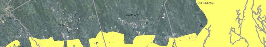
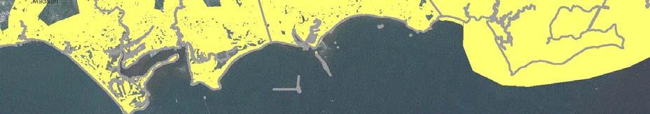

7 LiDAR Coverage

 + Wave")

8 Detailed Study Coastal Analysis Coastal analysis - includes 4 main components: Stillwater Level (storm surge) + Wave Set-up Overland Wave Propagation Wave Runup and Overtopping Primary Frontal Dune
9 Detailed Study Stillwater Level (SWEL) Return period gage analysis Linear interpolation between gage points Pool elevation
10 Detailed Study Wave Setup Numerically determined at each coastal transect Determining factors Average nearshore slope [depth of wave breaking to SWEL] Deepwater significant wave height SWEL + Wave Setup = Total Water Level (TWL) Areas where floodplain is restrictive, wave setup is removed and SWEL is mapped Constrictions such as low bridges Narrowing of the floodplain
11 Detailed Study Overland Wave Propagation Includes Wave Generation on Inland Water Bodies


12 Detailed Study Runup and Overtopping


13 Detailed Study Primary Frontal Dunes


14 Detailed Study Summary Significant Changes from previous study: Includes Wave Set-up Includes Wave Generation other than offshore waves Includes 2% Wave Runup Includes Primary Frontal Dune


15 Limit of Moderate Wave Action LiMWA Areas subject to wave heights greater than 1.5 feet Defines Coastal A Zone Recommendation of building to V zone standards Currently nonregulatory in Connecticut
16 Flood Risk Products - Background In 2010, FEMA funded creation of flood risk products for the 2009 studies These products are intended to help communities better understand and communicate flood risk GIS data such as parcels and building footprints were requested from the communities by STARR to be included in these products
17 Flood Risk Products - Background The following flood risk products were created for this study Changes Since Last FIRM (CSLF) Wave Height Grids Contributing Engineering Factors


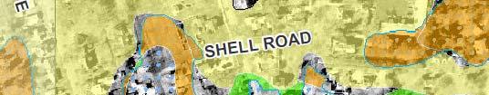
18 Flood Risk Products Changes Since Last FIRM SFHA Decrease SFHA Increase


19 Flood Risk Products Wave Height Grids Wave Height Grids Provided for 1% annual chance floods
20 Flood Risk Products Contributing Engineering Factors Provide insight into the factors behind the increase or decrease in the flood hazard areas Can prove to be useful for planning and mitigation measures
21 PLANNING
22 Middlesex County Timeline Activities Project Timeline Products Work Map Meeting May 24, 2011 Preliminary Projected September Effective 22, 2011 December 2012 CCO Meeting November 9, 2011 Projected LFD Dec 2012
23 Discover the Coastal Communities Understand local interest, issues, capabilities of communities Status of Mitigation Plan Communication desire, skills, resources Interest in and resources for mitigation Experience with flood disasters and recovery Floodplain administration Interest in cost-share Mitigation support needs and interests
24 Middlesex County Coastal Community Mitigation Plan Status Community Plan Expiration Date RPA Name (Multi) Plan Status t Clinton 1/18/2012 CRERPA Approved Fenwick 1/18/2012 CRERPA Included in the Old Saybrook Mitigation Plan Old Saybrook 1/18/2012 CRERPA Approved Westbrook 1/18/2012 CRERPA Approved
25 Discover FEMA Programs Flood Mitigation Assistance annual funding to reduce risk to NFIPinsured structures Hazard Mitigation Grant Program declared disaster funding for longterm hazard mitigation measures Pre-Disaster Mitigation Program annual funding for hazard mitigation planning and implementation Repetitive Flood Claims - annual funding to reduce risk to NFIP-insured structures with one or more claims Severe Repetitive Loss annual funding to reduce risk to NFIP-insured severe repetitive loss structures Community Rating System proactive communities receive insurance discounts for residents
26 POST-PRELIMINARY PRELIMINARY PROCESSING
27 Post-Preliminary Preliminary Phase Timeline Typical Post Preliminary Phase takes approximately 14 months to complete E Sept 22, 201 Nov 9, 2011 Est. Dec days Est. Dec days st. Mar Es st. June months Est. Dec Review and Appeal Period Compliance Period
28 Community Review 90-day Public Review and Appeal Period Appeals versus Protests/Comments Appeals The sole basis of appeal shall be the possession of knowledge or information indicating that the elevations proposed by FEMA are scientifically or technically incorrect. Protest or Comments Road or flooding source name change, changes to corporate limits, i etc. Changes to flood hazard delineations due to more detailed topographic p (elevation) information
29 Post-Preliminary Preliminary Processing Communities with new or modified Base Flood Elevations Town of Clinton Town of Old Saybrook Town of Westbrook Borough of Fenwick NOTE: All communities may review and submit comments during the 90-day time period
30 MYTHS! The 90- day appeal/protest p period is my only chance to change FEMA s maps? NO What are my other options? Letter of Map Amendments (LOMA): A request to FEMA for removal of individual properties p or structures from the SFHA Letter of Map Revisions (LOMR): A request to FEMA to modify an effective Flood Insurance Rate Map (FIRM), or Flood Boundary and Floodway Map (FBFM), or both. Results in the modification of the floodway, BFEs, or the Special Flood Hazard Area (SFHA).
31 Post-Preliminary Preliminary Processing Summary of Map Actions (SOMA) Background Letters of Map Change (LOMCs) are legally binding changes to the map Many LOMCs (such as Letters of Map Amendment) are not typically y reflected in the new FEMA maps due to scale constraints Some LOMCs are superseded when a new map is issued Summary of Map Actions is an assessment of all existing LOMCs compared with the new FEMA maps


32 Summary of Map Actions Category 1: shown on the new DFIRM panel Category 2: NOT shown on the new DFIRM panel due to scale limitations (revalidated after the new DFIRMs become effective)


33 Summary of Map Actions (continued) Category 3: superseded, and no longer valid, due to revised flood hazards Category 4: property owner must request this be re-determined
34 Post-Preliminary Preliminary Processing Revalidation of Letters of Map Change (LOMCs) The Summary of Map Actions (SOMA) is used to generate a Revalidation Letter The Revalidation Letter is issued to the community Community officials are encouraged to disseminate this information.
35 Post-Preliminary Preliminary Processing Revalidation Letter Distribution Community FEMA Regional Office NFIP State Coordinator LOMC Compendium NOT to Homeowners or Developers IS available through Map Service Center:
36 Post-Preliminary Preliminary Processing The compliance and map adoption period begins at the date the Letter of Final Determination is sent, and ends at the effective date. During the compliance and map adoption period, community officials review and, if appropriate, revise the community s floodplain ordinances to ensure they are compliant with NFIP regulations. Important! To avoid suspension from the NFIP, the community must adopt a compliant floodplain management ordinance and submit its ordinance to the FEMA Regional office (through the NFIP State Coordinator s Office) for approval prior to the end of the compliance and map adoption period.
37 STARR Contacts Buvana Ramaswamy, Task Order Manager, STARR Points of Contact CT Department of Energy and Environmental Protection State Contacts Diane Ifkovic, NFIP State Coordinator @ g Brian Caufield, Project Manager, STARR Brian.Caufield@starr-team.com FEMA Contacts Kerry Bogdan, Project Manager and Senior Engineer, FEMA Region I Kerry.Bogdan@dhs.gov David Mendelsohn, Post Preliminary Processing, FEMA Region I David.Mendelsohn@dhs.gov Marilyn Hilliard, Planning, FEMA Region I David.Mendelsohn@dhs.gov Carla Feroni, State Risk Map/Hazard Mitigation Grants Coordinator Carla.Feroni@ct.gov STARR Regional Service Center Laura Keating, RSC Lead, STARR Laura.Keating@starr-team.com Please send all comments/protests/appeals to: Brian Caufield, STARR, 50 Hampshire Street, Cambridge, MA Please copy: David Mendelsohn, FEMA Region 1, 99 High Street, 6 th Floor, Boston, MA Laura Keating, STARR, 99 High Street, 3 rd Floor, Boston, MA Carla Feroni, CT DEEP, 79 Elm Street, 3 rd Floor, Hartford, CT 06106
38 Who Do I Contact With Questions? For general FEMA mapping and LOMC questions contact FEMA s Map Information Exchange (FMIX): FEMA MAP ( ) or a Map Specialist: FEMAMapSpecialist@riskmapcds.com p p Map Service Center (MSC): where you can view effective maps online for free To learn more about the National Flood Insurance Program: or call


39 Questions?
Physical Map Revisions as a Result of Updated Coastal Flood Hazards
 Physical Map Revisions as a Result of Updated Coastal Flood Hazards Agenda Coastal Flood Hazard Analysis Recap Public Review and Appeal Period Effect on Existing Letters of Map Change Insurance Questions
Community Coordination Meeting. York County, Maine. Risk MAP Study
 Community Coordination Meeting York County, Maine Risk MAP Study January 9, 2014 Agenda Welcome and Introductions Project Timeline Flood Hazard Analysis Recap (Digital Conversion, Riverine and Coastal)
Community Coordination Meeting Sagadahoc County, Maine
 Community Coordination Meeting Sagadahoc County, Maine Risk MAP Study April 2, 2014 Agenda Welcome and Introductions Project Timeline Flood Hazard Analysis Recap Flood Risk Products Action: Hazard Mitigation
Nassau County, Florida Consultation Coordination Officer (CCO) Meeting. February 24, 2016 Fernandina Beach, Florida
 Meeting. February 24, 2016 Fernandina Beach, Florida") Nassau County, Florida Consultation Coordination Officer (CCO) Meeting February 24, 2016 Fernandina Beach, Florida Agenda Introductions Coastal Study Update Study Process and Timeline Flood Insurance Implications
Nassau County, Florida Consultation Coordination Officer (CCO) Meeting February 24, 2016 Fernandina Beach, Florida Agenda Introductions Coastal Study Update Study Process and Timeline Flood Insurance Implications
Duval County, Florida Consultation Coordination Officer (CCO) Meeting. January 25, 2017 Jacksonville, Florida
 Meeting. January 25, 2017 Jacksonville, Florida") Duval County, Florida Consultation Coordination Officer (CCO) Meeting January 25, 2017 Jacksonville, Florida Agenda Introductions Coastal Study Update Study Process and Timeline Flood Insurance Implications
Duval County, Florida Consultation Coordination Officer (CCO) Meeting January 25, 2017 Jacksonville, Florida Agenda Introductions Coastal Study Update Study Process and Timeline Flood Insurance Implications
St. Johns County, Florida Consultation Coordination Officer (CCO) Meeting. August 31, 2016 St. Augustine, Florida
 Meeting. August 31, 2016 St. Augustine, Florida") St. Johns County, Florida Consultation Coordination Officer (CCO) Meeting August 31, 2016 St. Augustine, Florida Agenda Introductions Coastal Study Update Study Process and Timeline Flood Insurance Implications
St. Johns County, Florida Consultation Coordination Officer (CCO) Meeting August 31, 2016 St. Augustine, Florida Agenda Introductions Coastal Study Update Study Process and Timeline Flood Insurance Implications
Martin County, Florida Consultation Coordination Officer (CCO) Meeting. March 22, 2018 Stuart, Florida
 Meeting. March 22, 2018 Stuart, Florida") Martin County, Florida Consultation Coordination Officer (CCO) Meeting March 22, 2018 Stuart, Florida Agenda Introductions Coastal Flood Risk Study Review Data Collected Storm Surge Modeling Overland Wave
Martin County, Florida Consultation Coordination Officer (CCO) Meeting March 22, 2018 Stuart, Florida Agenda Introductions Coastal Flood Risk Study Review Data Collected Storm Surge Modeling Overland Wave
Erie County Flood Risk Review Meeting. January 18, 2018
 Erie County Flood Risk Review Meeting January 18, 2018 Agenda The value of updated flood maps for your community Review updated flood-risk data and important next steps in the Risk MAP process Increasing
National Flood Insurance Program. Jennifer Gilbert, CFM, ANFI New Hampshire NFIP State Coordinator
 National Flood Insurance Program Jennifer Gilbert, CFM, ANFI New Hampshire NFIP State Coordinator What is the National Flood Insurance Program? Created by Congress in 1968 Participating Communities voluntarily
N.C. Floodplain Mapping Program
 N.C. Floodplain Mapping Program Current Status and Update April 23, 2018 NCFMP Program Objectives Purpose: Develop, Maintain, and Disseminate current, accurate, digital flood hazard data for all of NC,
OTTAWA COUNTY AND SANDUSKY COUNTY COMMUNITY CONSULTATION OFFICERS (CCO) MEETING December 7, 2017
 MEETING December 7, 2017") OTTAWA COUNTY AND SANDUSKY COUNTY COMMUNITY CONSULTATION OFFICERS (CCO) MEETING December 7, 2017 TODAY S AGENDA The Value of Updated Flood Maps for Your Community Reviewing the Updated Flood Risk Data
OTTAWA COUNTY AND SANDUSKY COUNTY COMMUNITY CONSULTATION OFFICERS (CCO) MEETING December 7, 2017 TODAY S AGENDA The Value of Updated Flood Maps for Your Community Reviewing the Updated Flood Risk Data
Updates to Maine Coastal Flood Insurance Rate Maps (FIRM s): What a Local Official Should Know. Presented by: Steve Johnson, P.E.
: What a Local Official Should Know. Presented by: Steve Johnson, P.E.") Updates to Maine Coastal Flood Insurance Rate Maps (FIRM s): What a Local Official Should Know Presented by: Steve Johnson, P.E. Town Engineer October 4, 2018 Introduction Federal Emergency Management
Updates to Maine Coastal Flood Insurance Rate Maps (FIRM s): What a Local Official Should Know Presented by: Steve Johnson, P.E. Town Engineer October 4, 2018 Introduction Federal Emergency Management
WAYNE COUNTY COMMUNITY CONSULTATION OFFICERS (CCO) MEETING. February 27, 2019
 MEETING. February 27, 2019") WAYNE COUNTY COMMUNITY CONSULTATION OFFICERS (CCO) MEETING February 27, 2019 TODAY S AGENDA Review the Updated Flood Risk Data for Your County Next Steps in the Map Adoption Process Understanding Flood
WAYNE COUNTY COMMUNITY CONSULTATION OFFICERS (CCO) MEETING February 27, 2019 TODAY S AGENDA Review the Updated Flood Risk Data for Your County Next Steps in the Map Adoption Process Understanding Flood
Durham County Preliminary Flood Hazard Data Public Meeting. July 28, 2016
 Durham County Preliminary Flood Hazard Data Public Meeting July 28, 2016 Why Are We Here New flood hazard data has been released as Preliminary for Durham County Statutory Due Process for review/comments
Abington Township Public Meeting
 Abington Township Public Meeting Flood Insurance Rate Map Update March 23, 2016 1 Meeting Agenda and Format Provide residents/property owners of Abington Township with information about the map update,
9/20/2016. Orange County Preliminary FIRM / Consultation Coordination Officer (CCO) Meeting
 Meeting") Orange County Preliminary FIRM / Consultation Coordination Officer (CCO) Meeting Open Pacific Coast Study September 21 and 22, 2016 1 Welcome and Introductions Preliminary FIRM / CCO Meeting Orange County
Orange County Preliminary FIRM / Consultation Coordination Officer (CCO) Meeting Open Pacific Coast Study September 21 and 22, 2016 1 Welcome and Introductions Preliminary FIRM / CCO Meeting Orange County
Taylor County, Florida Community Coordination and Outreach (CCO) Meeting
 Meeting") Taylor County, Florida Community Coordination and Outreach (CCO) Meeting Suwannee River Water Management District April 26, 2017 11:00AM to 12:00PM Taylor County Administration Building, 201 E. Green Street,
Taylor County, Florida Community Coordination and Outreach (CCO) Meeting Suwannee River Water Management District April 26, 2017 11:00AM to 12:00PM Taylor County Administration Building, 201 E. Green Street,
Preliminary DFIRM Community Coordination (PDCC) Meeting Gilchrist & Levy Counties, FL. April 30, 2015
 Meeting Gilchrist & Levy Counties, FL. April 30, 2015") Preliminary DFIRM Community Coordination (PDCC) Meeting Gilchrist & Levy Counties, FL April 30, 2015 Agenda 1. Introductions 2. Study Process and Timeline 3. Overview of Preliminary Products 4. Overview
Preliminary DFIRM Community Coordination (PDCC) Meeting Gilchrist & Levy Counties, FL April 30, 2015 Agenda 1. Introductions 2. Study Process and Timeline 3. Overview of Preliminary Products 4. Overview
Bullitt County, Kentucky Preliminary DFIRM Community Open House. October 8, 2014 Shepherdsville, Kentucky
 Bullitt County, Kentucky Preliminary DFIRM Community Open House October 8, 2014 Shepherdsville, Kentucky Meeting Agenda Introductions Overview of Preliminary DFIRMs Overview of Map Appeal Process Questions
Federal Emergency Management Agency
 Page 1 of 4 Issue Date: April 11, 2013 Case No.: DETERMINATION DOCUMENT COMMUNITY AND REVISION INFORMATION PROJECT DESCRIPTION BASIS OF REQUEST Town Of Stratford Fairfield County Connecticut NO PROJECT
Cameron County, TX. Consultation Coordination Officer (CCO) Meeting. Please sign in (sheet at front of the room) Meeting will begin at 9:00
 Meeting. Please sign in (sheet at front of the room) Meeting will begin at 9:00") Cameron County, TX Consultation Coordination Officer (CCO) Meeting Please sign in (sheet at front of the room) Meeting will begin at 9:00 July 29, 2015 Lisa Jennings FEMA Region 6 Roles & Responsibilities
Cameron County, TX Consultation Coordination Officer (CCO) Meeting Please sign in (sheet at front of the room) Meeting will begin at 9:00 July 29, 2015 Lisa Jennings FEMA Region 6 Roles & Responsibilities
Flood Map Revisions. Town of Nags Head Public Information and Input Session. December 14, 2016, 6 pm
 Flood Map Revisions Town of Nags Head Public Information and Input Session December 14, 2016, 6 pm Flood Map Revisions New preliminary flood maps released for Dare County June 30, 2016 www.nagsheadnc.gov/floodmaps
LOCAL OFFICIALS MEETING Lake Wausau Physical Map Revision MARATHON COUNTY, WISCONSIN FEBRUARY 9, 2017
 LOCAL OFFICIALS MEETING Lake Wausau Physical Map Revision MARATHON COUNTY, WISCONSIN FEBRUARY 9, 2017 Welcome & Introduction Michelle Staff Floodplain Management Policy Coordinator, WDNR Michelle.Staff@Wisconsin.gov
Calhoun County Flood Insurance Study Update
 Calhoun County Flood Insurance Study Update Larry Voice FEMA Region VI September 18, 2009 AGENDA Introduction Study Overview and Status Update Levees Post-Preliminary Process Outreach Moving Forward 2
Federal Emergency Management Agency
 Page 1 of 4 Issue Date: February 14, 2013 Effective Date: June 28, 2013 DETERMINATION DOCUMENT COMMUNITY AND REVISION INFORMATION City of Sunny Isles Beach Miami-Dade County Florida PROJECT DESCRIPTION
Community Officials Meeting. Plumas and Sierra County Physical Map Revision
 Community Officials Meeting Plumas and Sierra County Physical Map Revision March 6, 2014 Agenda Introductions/Sign In Project Scope Sierra Valley Flood Study (Plumas and Sierra Counties) North Yuba River
Location: Tampa, Florida March 6, 2013
 Discovery Meeting: West Florida Coastal Study Location: Tampa, Florida March 6, 2013 Agenda Introductions Why we are here Outline Risk MAP products and datasets Discovery Overview: Project scoping and
Orange County Flood Insurance Study Update
 Orange County Flood Insurance Study Update Larry Voice FEMA Region VI August 26, 2009 AGENDA Introduction Study Overview and Status Update Levees Post-Preliminary Process Outreach Moving Forward 2 Introduction
Kevin Wagner Maryland Department of the Environment
 Kevin Wagner Maryland Department of the Environment Topics Overview of the National Flood Insurance Program (NFIP) Mapping Regulations Insurance Mitigation Community Rating System (CRS) Questions Know
Enough about me! Topics Covered
 About Me Worked in land surveying since 1997 Employed by the City of Orlando since 2006 City of Orlando City Surveyor since February 2015 Certified Floodplain Manager since 2015 Florida Licensed Surveyor,
Herkimer County, New York Flood Hazard Mapping Status Report for Property Owners
 Herkimer County, New York Flood Hazard Mapping Status Report for Property Owners Herkimer County, New York Flood Hazard Mapping Status Report for Property Owners FLOOD INSURANCE Who Should Purchase Flood
Outreach Georgia Flood M.A.P. Program. GAFM Technical Conference Flood Risk Outreach and Policy Session
 Outreach Georgia Flood M.A.P. Program GAFM Technical Conference Flood Risk Outreach and Policy Session 7 th Annual Technical Conference, Lanier Islands March 29, 2012 Risk Communication Key Learnings People
Skagit County Flood Insurance Study Update. Ryan Ike, CFM FEMA Region 10
 Skagit County Flood Insurance Study Update Ryan Ike, CFM FEMA Region 10 Skagit County Flood Insurance Study Process Overview Process, Schedule, & Deliverables Base Flood Elevations, Modeling, & Levees
Delaware Bay / River Coastal Flood Risk Study. FEMA REGION II and III September 19, 2012
 Delaware Bay / River Coastal Flood Risk Study FEMA REGION II and III September 19, 2012 Agenda Risk MAP Program Overview Risk MAP Non-Regulatory Products & Datasets Region II New Jersey Coastal Flood Study
Consultation Coordination Officer (CCO) Meeting
 Meeting") Consultation Coordination Officer (CCO) Meeting Middle Brazos Lake Whitney Physical Map Revision Hill and McLennan Counties FEMA Region 6 Agenda National Flood Insurance Program Purpose of the Meeting
Consultation Coordination Officer (CCO) Meeting Middle Brazos Lake Whitney Physical Map Revision Hill and McLennan Counties FEMA Region 6 Agenda National Flood Insurance Program Purpose of the Meeting
Kentucky Risk MAP It s not Map Mod II
 Kentucky Risk MAP It s not Map Mod II Risk Mapping Assessment and Planning Carey Johnson Kentucky Division of Water carey.johnson@ky.gov What is Risk MAP? Risk Mapping, Assessment, and Planning (Risk MAP)
FEMA Region IX May 30-31, 2017
 Ventura County Preliminary Flood Maps FEMA Region IX May 30-31, 2017 National Flood Insurance Program U.S. Congress established the NFIP with the passage of the National Flood Insurance Act of 1968: 1.
Door County Floodplain Program Informational Meeting
 Door County Floodplain Program Informational Meeting Door County Land Use Services Department Wisconsin Department of Natural Resources January 15, 2018 Floodplain = Land affected by flood event with a
Federal Emergency Management Agency
 Page 1 of 3 COMMUNITY AND MAP PANEL INFORMATION COMMUNITY CITY OF MARGATE CITY, ATLANTIC COUNTY, NEW JERSEY LEGAL PROPERTY DESCRIPTION A parcel of land, as described in Deed recorded in Book 4826, page
Federal Emergency Management Agency
 Page 1 of 5 Issue Date: July 27, 2012 Effective Date: December 10, 2012 Case No.: 11-06-4512P Follows Conditional Case No.: 06-06-B789R LOMR-APP Federal Emergency Management Agency Washington, D.C. 20472
Federal Emergency Management Agency
 Page 1 of 4 Issue Date: August 1, 2012 Effective Date: December 13, 2012 Case No.: 12-06-0595P LOMR-APP Washington, D.C. 20472 LETTER OF MAP REVISION DETERMINATION DOCUMENT COMMUNITY AND REVISION INFORMATION
Sandy + BW-12: Changing the Equation for Building Safer, More Resilient Communities
 Sandy + BW-12: Changing the Equation for Building Safer, More Resilient Communities Grant Smith Jerry Sparks Jean Huang Ken Logsdon Stephanie Routh Session Agenda Moderators: Grant Smith & Jerry Sparks
Flood Risk Review (FRR) Meeting. Cumberland County, Pennsylvania Carlisle, Pennsylvania December 5, 2016
 Meeting. Cumberland County, Pennsylvania Carlisle, Pennsylvania December 5, 2016") Flood Risk Review (FRR) Meeting Cumberland County, Pennsylvania Carlisle, Pennsylvania December 5, 2016 Why are we here today? The Flood Insurance Study (FIS) report and Flood Insurance Rate Maps (FIRMs)
Flood Risk Review (FRR) Meeting Cumberland County, Pennsylvania Carlisle, Pennsylvania December 5, 2016 Why are we here today? The Flood Insurance Study (FIS) report and Flood Insurance Rate Maps (FIRMs)
Coastal Flood Insurance Studies in Virginia and Climate Change
 Coastal Flood Insurance Studies in Virginia and Climate Change VFMA Floodplain Management Workshop October 22, 2015 Jeff Gangai Why is a Coastal Restudy Needed? New Guidelines need to be implemented Atlantic
Preliminary Work Map Release
 Coastal Mapping in New Jersey Preliminary Work Map Release Monmouth County, New Jersey June 14, 2013 Agenda Introduction and Purpose of Briefing Hurricane Sandy Advisory Base Flood Elevations Transitioning
Bucks County, PA Flood Risk Review Meeting. November 2014
 Bucks County, PA Flood Risk Review Meeting November 2014 Agenda for Today Risk MAP Program overview Overview of non-regulatory Flood Risk Products and datasets Discuss mitigation action Technical overview
Best Practices. for Incorporating Building Science Guidance into Community Risk MAP Implementation November 2012
 Best Practices for Incorporating Building Science Guidance into Community Risk MAP Implementation November 2012 Federal Emergency Management Agency Department of Homeland Security 500 C Street, SW Washington,
FOR LOCAL GOVERNMENTS
 FLOOD MAP OUTREACH PLANNING GUIDEBOOK FOR LOCAL GOVERNMENTS Version 1.1 Georgia Department of Natural Resources March 2010 Dear Community Official: Georgia s Department of Natural Resources (DNR) has partnered
Lake Erie. June 10 & 11, 2014
 Discovery Meeting: Lake Erie FEMA REGION II June 10 & 11, 2014 Lake Erie Contributing Watersheds eds Introductions and Who s Here Project Team FEMA Region II RAMPP Local Stakeholders Invited Local Community
Federal Emergency Management Agency
 Page 1 of 6 Issue Date: September 27, 2010 Effective Date: February 14, 2011 Follows Conditional Case No.: 08-08-0873R DETERMINATION DOCUMENT COMMUNITY AND REVISION INFORMATION PROJECT DESCRIPTION BASIS
NFIP Mapping Issues. Wendy Lathrop, PLS, CFM. Cadastral Consulting, LLC
 NFIP Mapping Issues Cadastral Consulting, LLC NFIP Basic Objectives: Reduce the exposure to flood damages through the use of minimum standards for the placement and design of structures located in flood
Flood Risk Products. New Techniques for Identifying and Communicating Flood Risk
 Flood Risk Products New Techniques for Identifying and Communicating Flood Risk Mark Zito, GISP, CFM GIS Specialist Amol Daxikar, GISP, CFM Project Manager March 28, 2012 1% Flood with 3 Feet Sea Level
RichSmith_slate-FEMA_320x240.wmv.
 Nebraska DNR s role in the making of FEMA s Digital Flood Insurance Rate Maps Becky Groshens (grow-hands) & Shelley Schindler Important Terms: FIRM: Flood Insurance Rate Map FIS: Flood Insurance Study
Non Regulatory Risk MAP Products Flood Depth and Probability Grids
 Non Regulatory Risk MAP Products Flood Depth and Probability Grids Virginia Floodplain Management Association 2015 Floodplain Management Workshop October 29th, 2015 Nabil Ghalayini, P.E., PMP, D.WRE, CFM
Requirements for Construction on Properties in the Special Flood Hazard Area (SFHA)
") Requirements for Construction on Properties in the Special Flood Hazard Area (SFHA) Rev 010915 The website for the IDNR to request the EFARA (Electronic Floodplain Analysis/Regulatory Assessment is found
Requirements for Construction on Properties in the Special Flood Hazard Area (SFHA) Rev 010915 The website for the IDNR to request the EFARA (Electronic Floodplain Analysis/Regulatory Assessment is found
Northern Alameda County Consultation Coordination Officer (CCO) Meeting
 Meeting") MEETING TITLE: DATE AND TIME: Northern Alameda County Consultation Coordination Officer (CCO) Meeting May 27, 2015, 1:30 to 3:30 p.m. LOCATION: 950 West Mall Square, Room 201 Alameda, CA ATTENDEES: Eric
MEETING TITLE: DATE AND TIME: Northern Alameda County Consultation Coordination Officer (CCO) Meeting May 27, 2015, 1:30 to 3:30 p.m. LOCATION: 950 West Mall Square, Room 201 Alameda, CA ATTENDEES: Eric
Flood Analysis Memo. 629 Orangewood Dr. Dunedin, FL BFE = 21 ft
 Flood Analysis Memo Property Address 629 Orangewood Dr. In Partnership with: ** This property is NOT within a high-risk flood zone ** 629 Orangewood Dr. BFE = 21 ft This property is located in the FEMA
Federal Emergency Management Agency
 Page 1 of 4 Issue Date: April 26, 2013 DETERMINATION DOCUMENT COMMUNITY AND REVISION INFORMATION PROJECT DESCRIPTION BASIS OF REQUEST City of Coppell Dallas County Texas FILL HYDRAULIC ANALYSIS NEW TOPOGRAPHIC
Georgia Flood M.A.P. Program Risk MAP Plenary Session GAFM 2011
 Georgia Flood M.A.P. Program Risk MAP Plenary Session GAFM 2011 Collis Brown, Georgia DNR March 24, 2011 GA Flood Map Modernization Responsible for end-to-end production Developed aggressive outreach program
JAXGIS FEMA Flood Hazard Mapping -- Frequently Asked Questions
 Flood Hazard Zone Designations Summary Zones starting with the letter 'A' (for instance, Zone A, Zone AE, Zone AH, Zone AO) denote a Special Flood Hazard Area, which can also be thought of as the 100-year
Federal Emergency Management Agency
 Page 1 of 4 Issue Date: September 7, 2012 Effective Date: January 22, 2013 DETERMINATION DOCUMENT COMMUNITY COMMUNITY AND REVISION INFORMATION City of Lubbock Lubbock County Texas PROJECT DESCRIPTION CHANNELIZATION
National Capitol Region HAZUS User Group Call
 Listen to the recording here to follow along with the presentation: http://www.freeconferencecalling.com/recordings/recording.aspx?fileid=l AF3494_04252013070630062_1154707&bridge=697620&email=&account
FLOODPLAIN FAQ s. Last Update: June 2017
 FLOODPLAIN FAQ s Last Update: June 2017 What does FEMA stand for? Federal Emergency Management Agency - the operation of FEMA is to lead America to prepare for, prevent, respond to, and recover from disasters.
Facts & Info regarding the NFIP in Mathews County VA And the Mathews County Floodplain Management Ordinance
 Facts & Info regarding the NFIP in Mathews County VA And the Mathews County Floodplain Management Ordinance As of 05-31-2014: Current NFIP policies in Mathews County = 1687 NFIP Claims= 1127, for a total
Discovery Meeting: Lake Ontario. FEMA REGION II November 12-14, 2013 and November 19-21, 2013 Lake Ontario Contributing Watersheds
 Discovery Meeting: Lake Ontario FEMA REGION II November 12-14, 2013 and November 19-21, 2013 Lake Ontario Contributing Watersheds Introductions and Who s Here Project Team FEMA Region II Dewberry New York
Federal Emergency Management Agency
 Page 1 of 5 Issue Date: October 28, 2009 Follows Conditional Case No.: 08-08-0612R DETERMINATION DOCUMENT COMMUNITY AND REVISION INFORMATION PROJECT DESCRIPTION BASIS OF REQUEST COMMUNITY Lincoln County
Cumberland County, NJ. Risk MAP Project Status Update April 22, 2013
 Cumberland County, NJ Risk MAP Project Status Update April 22, 2013 Agenda Project Team Milestones Risk MAP Overview Study Scope overview Regulatory products Non-regulatory products Proposed Schedule Risk
Federal Emergency Management Agency
 Page 1 of 4 Issue Date: October 2, 2017 Effective Date: October 2, 2017 Case No.: 17-09-2731P LOMR-APP Federal Emergency Management Agency Washington, D.C. 20472 LETTER OF MAP REVISION DETERMINATION DOCUMENT
THE $64,000 FLOOD INSURANCE BILL
 THE $64,000 FLOOD INSURANCE BILL GEORGIA ASSOCIATION OF FLOODPLAIN MANAGERS 9 TH ANNUAL TECHNICAL CONFERENCE Patrick Gervais, PE, CFM A CASE STUDY IN FLOOD INSURANCE This is a true story that happened
Floodplain Management 101: UNIT II. Maps & Flood Insurance Studies
 Floodplain Management 101: UNIT II Maps & Flood Insurance Studies Who is ASFPM? ASFPM stands for the Association of State Floodplain Managers A national organization of floodplain management professionals
What Was Updated in 2004 in Hennepin Countywide Maps?
 What Was Updated in 2004 in Hennepin Countywide Maps? Combined the city and township maps into one countywide index Done by USACE Mainly digital capture of old floodplain boundaries; some spots with shifts
Using Non-Regulatory RiskMAP Products in Floodplain Management. Ferrin Affleck, PE, CFM, Water Resources Engineer Project Manager Atkins
 Using Non-Regulatory RiskMAP Products in Floodplain Management Ferrin Affleck, PE, CFM, Water Resources Engineer Project Manager Atkins 1 Goal of this Presentation Inform Peak interest Stimulate creativity
ASSUMPTION PARISH, LOUISIANA AND INCORPORATED AREAS
 VOLUME 1 of 1 ASSUMPTION PARISH, LOUISIANA AND INCORPORATED AREAS COMMUNITY NAME ASSUMPTION PARISH UNINCORPORATED AREAS COMMUNITY NUMBER 220017 NAPOLEONVILLE, TOWN OF 220018 REVISED PRELIMINARY November
Floodplain Management 101. Mississippi Emergency Management Agency Floodplain Management Bureau
 Floodplain Management 101 Mississippi Emergency Management Agency Floodplain Management Bureau Stafford Act The Stafford Disaster Relief and Emergency Assistance Act (Stafford Act) (Public Law 100-707)
COLLIER COUNTY FLOODPLAIN MANAGEMENT
 COLLIER COUNTY FLOODPLAIN MANAGEMENT FREQUENTLY ASKED QUESTIONS The following information is based on common questions from the public. If you have a specific question or need further information, please
Federal Emergency Management Agency
 Page 1 of 5 Issue Date: October 16, 2014 Effective Date: March 2, 2015 Case No.: 14-09-2279P LOMR-APP Federal Emergency Management Agency Washington, D.C. 20472 LETTER OF MAP REVISION DETERMINATION DOCUMENT
Southwest Florida Discovery Kick-Off Meeting. February 4, 2014
 Southwest Florida Discovery Kick-Off Meeting February 4, 2014 Agenda Introductions Outline Risk MAP products and datasets Project scoping and schedule Data gathered Next steps Gather stakeholder input/feedback
Georgia Flood M.A.P. Program
 Georgia Flood M.A.P. Program Georgia Flood M.A.P. Program The Upper Chattahoochee River Basin Risk MAP Project Transitioning State Program to align with FEMA s Risk MAP Program Increase focus on risk assessment
Accounting for Long-Term Erosion and Sea Level Rise in New England: A TMAC Recommendation
 Accounting for Long-Term Erosion and Sea Level Rise in New England: A TMAC Recommendation Elena Drei-Horgan, PhD, CFM Jeremy Mull, PE Brian Caufield, PE May 2017 Establishment of TMAC, Definition, Members
History of Floodplain Management in Ascension Parish
 History of Floodplain Management in Ascension Parish presented by: Kara Moree Floodplain Coordinator February 6, 2012 Floodplain 101 Floodplain 101 Base or 1% Flood: A flood having a 1% chance of being
Panel Decision & Report. SRP MAES Ring s Island, Salisbury, Essex County, Massachusetts
 Panel Decision & Report SRP MAES042211 Ring s Island, Salisbury, Essex County, Massachusetts Table of Contents Summary... 2 About the Scientific Resolution Panel (SRP) and Authority... 2 Panel Members...
Federal Emergency Management Agency
 age 1 of 4 Issue Date: April 16, 2013 Effective Date: August 30, 2013 DETERMINATION DOCUMENT COMMUNITY AND REVISION INFORMATION ROJECT DESCRITION BASIS OF REQUEST City of Naples Collier County Florida
Questions about the National Flood Insurance Program
 Questions about the National Flood Insurance Program Federal Emergency Management Agency (FEMA) Questions and Answers What is the National Flood Insurance Program (NFIP)? The NFIP is a Federal program
210 W Canal Dr Palm Harbor, FL 34684
 Flood Analysis Memo Property Address In Partnership with: ** This property is within a high risk flood zone ** BFE = 6 ft This property is located in the FEMA designated high-risk zone, Zone AE - an area
AGENDA PLANNING ADVISORY BOARD SUBCOMMITTEE INDUSTRIAL STANDARDS FOR CONSTRUCTION WITHIN A FLOODPLAIN THURSDAY, AUGUST 25, :00-5:00 P.M.
 AGENDA PLANNING ADVISORY BOARD SUBCOMMITTEE INDUSTRIAL STANDARDS FOR CONSTRUCTION WITHIN A FLOODPLAIN THURSDAY, AUGUST 25, 2016 3:00-5:00 P.M. CITY COMMISSION CHAMBERS 204 ASH STREET FERNANDINA BEACH,
10526 Bermuda Isle Dr. Tampa, FL 33647
 Flood Analysis Memo Property Address 10526 Bermuda Isle Dr. In Partnership with: ** This property is NOT within a high-risk flood zone ** 10526 Bermuda Isle Dr. BFE = 35 ft This property is located in
Federal Emergency Management Agency
 Page 1 of 4 Issue Date: April 29, 2011 DETERMINATION DOCUMENT COMMUNITY COMMUNITY AND REVISION INFORMATION City of Simi Valley Ventura County California PROJECT DESCRIPTION NO PROJECT BASIS OF REQUEST
F E M A Mapping Changes. FEMA Mapping Changes. National Flood Insurance Program
 FEMA Mapping Changes National Flood Insurance Program 1 Welcome to FEMA Mapping Changes! We will get started in a few minutes. Meanwhile, let s perform a warm up exercise. 2 1 Training Agenda Section 1-
National Coastal Outreach
 National Coastal Outreach Answering Tough Questions June 11, 2013 Why Focus on Coastal Flood Risk? 120,475,000 people or 39% of the U.S. population live in counties subject to the 1% annual chance coastal
NFIP Overview Elevation Certificate Flood Insurance Rate Maps. By: Maureen O Shea, AICP, CFM State NFIP Coordinator
 NFIP Overview Elevation Certificate Flood Insurance Rate Maps By: Maureen O Shea, AICP, CFM State NFIP Coordinator Example of a flood failure Example of a flood failure Purposes of the NFIP Identify &
10526 Bermuda Isle Dr. Tampa, FL 33647
 Flood Analysis Memo Property Address In Partnership with: ** This property is NOT within a high-risk flood zone ** This property is located in a FEMA low-risk zone designated as Zone X - an area of minimal
Federal Emergency Management Agency
 Page 1 of 5 Issue Date: June 21, 2013 Follows Conditional Case No.: 04-06-A148R DETERMINATION DOCUMENT COMMUNITY COMMUNITY AND REVISION INFORMATION City of Irving Dallas County Texas FILL PROJECT DESCRIPTION
Chemung HUC-8 Watershed Project. February 1, 2011
 Chemung HUC-8 Watershed Project Kickoff Bi Fl t NY Big Flats, NY February 1, 2011 Introductions FEMA Region II Alan Springett, Senior Engineer, FEMA Risk Analysis Risk Assessment Lead Robert Schaefer,
Modernization, FEMA is Recognizing the connection between damage reduction and
 EXECUTIVE SUMMARY Every year, devastating floods impact the Nation by taking lives and damaging homes, businesses, public infrastructure, and other property. This damage could be reduced significantly
Introduction to the National Flood Insurance Program: A Guide for Coastal Property Owners MAINE BEACHES CONFERENCE 2017
 Introduction to the National Flood Insurance Program: A Guide for Coastal Property Owners MAINE BEACHES CONFERENCE 2017 SUE BAKER, CFM STATE NFIP COORDINATOR MAINE DEPT OF AGRICULTURE, CONSERVATION & FORESTRY
Federal Emergency Management Agency
 Page 1 of 6 Issue Date: May 13 2016 Case No.: Follows Conditional Case No.: 14-05-0595R DETERMINATION DOCUMENT COMMUNITY AND REVISION INFORMATION PROECT DESCRIPTION BASIS OF REQUEST COMMUNITY Village of
Using GISWeb to Determine Your Property s Flood Zone
 Using GISWeb to Determine Your Property s Flood Zone 1. In a new browser window, go to http://www.co.santacruz.ca.us/departments/geographicinformationsystemsgis.aspx 2. Click on GISWeb - GIS Mapping Application
Glossary. Frequently Used Terms for Levees
 Glossary Frequently Used Terms for Levees The terms listed below will regularly be encountered by FEMA mapping partners, stakeholders, and users that are actively involved in the Flood Map Modernization
July 31, 2017 NFIP Flood Map Open House Flood Maps 101 Flood Mapping acronyms History of the NFIP Flood Mapping Updates Flood Insurance Fairhope,
 July 31, 2017 NFIP Flood Map Open House Flood Maps 101 Flood Mapping acronyms History of the NFIP Flood Mapping Updates Flood Insurance Fairhope, Alabama Flood Maps Fairhope Permitting Jurisdiction Coastal
Maryland Model Floodplain Management Ordinance (May, 2014) MODEL NOTES
 MODEL NOTES") Maryland Model Floodplain Management Ordinance (May, 2014) MODEL NOTES The model floodplain management ordinance that most Maryland communities have used as the basis for their regulations since the early
Maryland Model Floodplain Management Ordinance (May, 2014) MODEL NOTES The model floodplain management ordinance that most Maryland communities have used as the basis for their regulations since the early