National Institute of Building Sciences
|
|
|
- Morris Hamilton
- 5 years ago
- Views:
Transcription
 Stuart J.")
1 National Institute of Building Sciences Provider Number: G168 Improving the Flood Resistance of Buildings and Mitigation Techniques WE3B Peter Spanos, P.E., CFM, LEED AP (Gale Associates, Inc.) Stuart J. Ulsh (FM Global) January 9th, 2019
2 Credit(s) earned on completion of this course will be reported to AIA CES for AIA members. Certificates of Completion for both AIA members and non-aia members are available upon request. This course is registered with AIA CES for continuing professional education. As such, it does not include content that may be deemed or construed to be an approval or endorsement by the AIA of any material of construction or any method or manner of handling, using, distributing, or dealing in any material or product. Questions related to specific materials, methods, and services will be addressed at the conclusion of this presentation.
3 Course Description Severe flooding can endanger life, but even moderate levels of flooding can lead to extensive damages and disruption of building operations. Water source contamination and inhibited access are significant problems, coupled with damages to structures and interior contents. Contaminated water can destroy electrical infrastructure, mechanical systems, etc. Business interruption can last from a few days to over a year. Due to climate change and revisions to FEMA flood maps in 2016, many buildings not previously categorized as being at risk are now categorized as subject to flooding. As a result, insurers are informing their clients of the potential risks and associated increases in flood insurance coverage, if flood mitigation procedures are not enacted. This presentation will discuss how to identify areas of facilities vulnerable to flooding, and the options and systems available to protect properties from potentially catastrophic damages to structures, building contents and impacts on building operations. The speakers will focus on addressing potential hazards at existing facilities. It is usually not as easy as building a levee around the property. Oftentimes, a hybrid solution must be developed, incorporating a variety of systems, including barriers, flood gates, deployable flood walls, backflow devices, storage tanks and ejector pumps, upgraded stormwater systems, etc.
4 Learning Objectives At the end of the this course, participants will be able to: 1. Identify areas of facilities vulnerable to flooding 2. Identify options available to mitigate flooding 3. Review process of flood mitigation design and associated construction phasing. 4. Create a flood emergency response plan


5 Weather Trends and Effects Upon Sea Level Rise and Rainfall Amounts Types of Flooding / Design Criteria Understanding Floodplain Mapping Flood Hazard Mitigation / Management Plans Case Studies


6


7


8

9 Difference from 20 th century average ( C) o C = 7% more water vapor NOAA National Centers for Environmental information, Climate at a Glance: Global Time Series, published January 2018, from Global Mean Temperature is Increasing

10 Observed Change in Very Heavy Precipitation NCA3_Climate_Change_Impacts
11 Types of Flooding

12

13 Sheet Flow Localized Site Flooding Not Associated with a FEMA Flood Zone
")

14 Rivers and Streams Zone A / AE 1% Base Flood Elevation (100 year flood plain) Floodway Velocity Zone Zone X - 0.2% Base Flood Elevation (500 year flood plain)


15 Coastal Coastal Zone VE & A/AE Wave Action Zone A/AE Stillwater (1% BFE) Zone X Stillwater (0.2% BFE)

16 Coastal FEMA Flood Zones


17 Types of Flood Damage: Hydrodynamic Forces Debris Impact Hydrostatic Forces Soaking Sediment and Contaminants
18 Understanding Floodplain Mapping

19 National Flood Insurance Program (NFIP) Created in 1968; changes under National Flood Insurance Reform Act of 1994 Based on a mutual agreement between Federal Government and community Three basic parts Mapping Insurance Regulations


20


21

 and Structure Classification FEMA")
 Regulations (44 CFR Parts 59 and 60) International Building")
22 ASCE 24 Flood Resistant Design & Construction Minimum design and construction of structures in flood hazard areas (new construction, substantial Improvements, historic structure exceptions) Meets or Exceeds NFIP regulations Requirements are functions of Flood Hazard Areas (Zone A, V, other high risk) and Structure Classification FEMA Technical Bulletins FEMA P936 Floodproofing Non-Residential Buildings National Flood Insurance Program (NFIP) Regulations (44 CFR Parts 59 and 60) International Building Codes (I-Codes)

23

24

25 Dry Flood Proofing: A combination of measures that results in a structure, including the attendant utilities and equipment, being watertight with all elements substantially impermeable to the entrance of floodwater and with structural components having the capacity to resist flood loads. Building strength/building locations Warning time Flood characteristics Level of protection Seepage considerations Utilities

26 Wet Flood Proofing: The use of flood-damage-resistant materials and construction techniques to minimize flood damage to areas below the flood protection level of a structure, which is intentionally allowed to flood. Building strength Warning time Flood-damage-resistant-materials Utilities
27 Building Code Consultant Geotechnical Engineering MEP Engineering Owner/ Insurance Carrier Flood Design Team Civil Engineering Structural Engineering Architect Enclosure/ Waterproofing Expertise
28 Flood Risk

29 2017: 3 Hurricanes, 26 Days, 2500 loss locations, $75-$145 billion loss estimated industry wide

30 Hurricane Harvey was a Flood Event

31 The Value of Risk Improvement

32 Flood losses experienced by FM Global clients who met our guidelines cost almost 5x less than those that did not Hurricane Harvey

33 FM Global clients completed physical improvements and reduced their overall loss exposure by $820 million/$23 million average Hurricane Harvey
 Identify options available to mitigate flooding ANSI/FM 2510 Approved")
34 Flood Hazard Mitigation: Resiliency Goals Identifying areas of facilities vulnerable to flooding Develop flood emergency response plan (FERP) Identify options available to mitigate flooding ANSI/FM 2510 Approved Products
35 FERP - Simple Steps During Normal Working Hours to Mitigate Loss Monitor Weather Authority to Activate Ample Time Plan for Recovery Review after each Implementation

36 Match the Right Solution to the Scenario (Warning and Installation Time)

37 If you are flood exposed, what can you do? Besides moving out of the flood zone!


38 Raise Equipment and Supplies
39 Flood Barrier Examples


40 Protect Openings Check all water entry points: Front door Side door Loading dock door Windows Vents Pipe penetrations Underground pipes


41 Protect individual pieces of equipment or portions of the building
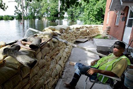
42

43
44 Flood Mitigation Products Perimeter Barriers

45 Permanent Flood Protection Barriers


46 All Barriers Should Meet ANSI/FM 2510 Standards

47 Perimeter flood panel system


48 Flood Protection for Subway Vents Queens, NY
49 Flood Mitigation Products Opening Barriers


50 Automatic Pop-Up

51 Manually Deployed Opening Barrier

52 One Client s Story: Flooded in May 2015 and April 2016 Office tower Outside the 500-year zone Four feet of water in garage Building utilities located in garage

53

54
55 During

56 The Result
57 Case Study River / Stream

58 FEMA Map Overlay

59


60

61 Close to Building

62 Slope of Land

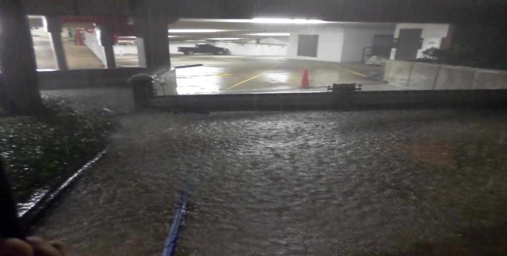
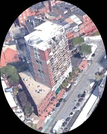
63 A River Runs Through It
64 Case Study: Lexington, MA

65 Site located adjacent to Kiln Brook and wetlands associated with the Shawsheen River.


66 Site within AE Zone and Regulatory Floodway Base Flood Elevation (BFE) is

67 Base Flood Elevation (BFE) is Surveyed first floor found to be at Building is 6 below BFE

68 Floor mounted HVAC vents


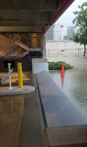
69 Electrical/Mechanical Equipment Located on First Floor


70 Proposed Building Use: Office, Laboratory Space, and Cleanrooms Flood Mitigation Options: Wet Flood Proofing Relocating all laboratory and cleanrooms to the second floor and installing isolated interior protection around mechanical, electrical, and communications rooms Dry Flood Proofing Providing full building perimeter protection by installing permanent and/or temporary flood mitigation measures.

71 Option 1 Flood panel perimeter system

72 Option 1 Flood panel perimeter system

73 Option 2 permanent perimeter system with smaller openings
74 Option 2 permanent perimeter system with smaller openings
75 Case Study: Atlantic Avenue, Boston, MA


76


77 FEMA Flood Map / AE Zone, BFE Elev. 10

78 First Floor / Garage, ELEV=10.2 BFE=10 First Floor 2 above BFE Basement 9 ½ below BFE

79 Lower Level Basement Access Open Grated for Boiler Ventilation

80 Louver Penetrations

81 View from Sidewalk, Concrete Grade Beam

82 Continuous and Approved Flood Barrier

83 Main Entrance Unprotected

84 Flood Barrier at Entrance, Garage and Basement Access
85 Changing How We Think


86 What Does It Take to Make Futuristic Ideas the Norm?


87 What Does It Take to Make Futuristic Ideas the Norm?

88 Key Takeaways Storms Have Increased in Severity and Frequency Even if You re Not in Flood Zone, You May Still Be Flood Exposed If You Are Exposed, There Are Things You Can Do to Minimize Risk

89 This concludes The American Institute of Architects Continuing Education Systems Course
National Flood Insurance Program (NFIP) for Real Estate Professionals
 for Real Estate Professionals") National Flood Insurance Program (NFIP) for Real Estate Professionals 1 Joshua Oyer, CFM Outreach Specialist NFIP State Coordinator s Office at the Texas Water Development Board 2 Outline Introduction
National Flood Insurance Program (NFIP) for Real Estate Professionals 1 Joshua Oyer, CFM Outreach Specialist NFIP State Coordinator s Office at the Texas Water Development Board 2 Outline Introduction
Upper Joachim Creek Public Survey on Potential Flood Risk Reduction
 Upper Joachim Creek Public Survey on Potential Flood Risk Reduction This survey is intended to help the interagency planning committee to receive public feedback on specific flood risk reduction techniques,
Floodplain Design, Construction, and Impacts On Flood Insurance
 Floodplain Design, Construction, and Impacts On Flood Insurance AIA/CES Registration Architectural Record is a registered provider with The American Institute of Architects Continuing Education Systems.
Article 23-6 FLOODPLAIN DISTRICT
 AMENDING THE CODE OF THE CITY OF PITTSFIELD CHAPTER 23, ZONING ORDINANCE SECTION I That the Code of the City of Pittsfield, Chapter 23, Article 23-6 Floodplain District, shall be replaced with the following:
Chapter 6 - Floodplains
 Chapter 6 - Floodplains 6.1 Overview The goal of floodplain management is to reduce the potential risks to both existing and future developments, and infrastructure, in the 100-year floodplain. Over the
YOLO COUNTY FLOODPLAIN MANAGEMENT PROGRAM
 YOLO COUNTY FLOODPLAIN MANAGEMENT PROGRAM Answers to Commonly Asked Questions and A Guide for Residential Construction Within Special Flood Hazard Areas The automatic entry and exit of flood water); Or
Requirements for Mapping Levees Complying with Section of the NFIP Regulations
 FACT SHEET Requirements for Mapping Levees Complying with Section 65.10 of the NFIP Regulations As part of a mapping project, it is the levee owner s or community s responsibility to provide data and documentation
The Power of Water: How to Prepare and Protect Your Business from Floods
 Hanover Risk Solutions The Power of Water: How to Prepare and Protect Your Business from Floods Each year, the United States suffers hundreds of millions, or even several billions, of dollars in flood
Appendix D - Floodplain Documents
 City of Aspen Urban Runoff Management Plan Appendix D - Floodplain Documents 1. Floodplain Development Permit 2. Elevation Certificate and Instructions 3. Floodproofing Certificate for Non-Residential
Flood Resistant Provisions of Connecticut s Newest Building Codes. Laura E. Ghorbi, PE, CFM Risk Management & Resilience
 Flood Resistant Provisions of Connecticut s Newest Building Codes Laura E. Ghorbi, PE, CFM Risk Management & Resilience October 25, 2017 Overview 2018 Connecticut State Building Code Adoption National
DES MOINES CITY OF TWO RIVERS. Flooding Risk & Impact to Development
 DES MOINES CITY OF TWO RIVERS Flooding Risk & Impact to Development River System Des Moines Flood Protection Des Moines Flood Protection cont. Infrastructure Over 24 miles of levees 21stormwater pump stations
CONTRA COSTA COUNTY FLOODPLAIN MANAGEMENT PROGRAM
 CONTRA COSTA COUNTY FLOODPLAIN MANAGEMENT PROGRAM Answers to Commonly Asked Questions and A Guide for Residential Construction Within Special Flood Hazard Areas Revised February 2015 Introduction Ninety
THE FLOOD HAZARD AREA Valda Opara New Jersey Department of Environmental Protection June 8, 2012
 THE FLOOD HAZARD AREA Valda Opara New Jersey Department of Environmental Protection June 8, 2012 Individual Permits Building Requirements 0% Net-fill Standards JET SKIING DURING A FLOOD ESCAPING THE FLOOD
Flood Vulnerability Assessment for Critical Facilities. Molly Woloszyn Lisa Graff, GISP, CFM
 Flood Vulnerability Assessment for Critical Facilities Molly Woloszyn Lisa Graff, GISP, CFM 2011 University of Illinois Board of Trustees. All rights reserved. For permission information, contact the Illinois
Oak Island 1999 Hurricane Floyd
 Oak Island 1999 Hurricane Floyd Topics to be Discussed What is a flood zone Flood zones in Oak Island Special Flood Hazard Areas (SFHA) Flood insurance Base Flood Elevations (BFEs) Building in flood zones
FEMA Elevation Certificates and Hydrostatic Venting Requirements
 FEMA Elevation Certificates and Hydrostatic Venting Requirements Tennessee Association of Floodplain Managers Conference Gatlinburg, TN July 30 August 2, 2013 1 What is the National Flood Insurance Program
TOWN OF KENT, CT PLANNING AND ZONING COMMISSION
 TOWN OF KENT, CT PLANNING AND ZONING COMMISSION FLOOD PLAIN MANAGEMENT REGULATIONS Whereas, Congress has determined that a National Flood Insurance Program would alleviate personal hardships and economic
Floodplain Development Permit Application
 Floodplain Development Permit Application City of Jonesboro, AR This is an application packet for a Floodplain Development Permit. Certain sections are to be completed by the Applicant, and certain sections
a) Ensure public safety through reducing the threats to life and personal injury.
 Ensure public safety through reducing the threats to life and personal injury.") SECTION VII: FLOODPLAIN DISTRICT 7-1 Statement Of Purpose The purposes of the Floodplain District are to: a) Ensure public safety through reducing the threats to life and personal injury. b) Eliminate
SECTION VII: FLOODPLAIN DISTRICT 7-1 Statement Of Purpose The purposes of the Floodplain District are to: a) Ensure public safety through reducing the threats to life and personal injury. b) Eliminate
ADVISORY BASE FLOOD ELEVATIONS (ABFEs)
") The Department of Homeland Security s Federal Emergency Management Agency is committed to helping communities that were impacted by Hurricanes Katrina and Rita rebuild safer and stronger. Following catastrophic
The Department of Homeland Security s Federal Emergency Management Agency is committed to helping communities that were impacted by Hurricanes Katrina and Rita rebuild safer and stronger. Following catastrophic
RiskTopics. Guide to flood emergency response plans September 2017
 RiskTopics Guide to flood emergency response plans September 2017 While floods are a leading cause of property loss, a business owner can take actions to mitigate and even help prevent damage and costly
COASTALRISK. FLOODANDNATURALHAZARDRISKASSESSMENT Commercial Mayport Naval Station, Jacksonville, FL September 7, 2018
 COASTALRISK FLOODANDNATURALHAZARDRISKASSESSMENT Commercial September 7, 2018 THISREPORTISPROVIDEDSUBJECTTOTHECOASTALRISKCONSULTING,LLC.TERMSANDCONDITIONSOFUSE,WHICHIS AVAILABLEATWWW.COASTALRISKCONSULTING.COM.THISANALYSISISFURNISHED
Flood Risk Management and Nonstructural Flood Risk Adaptive Measures
 Flood Risk Management and Nonstructural Flood Risk Adaptive Measures Randall Behm, P.E., CFM USACE-Omaha District Chair, National Nonstructural Flood Proofing Committee US Army Corps of Engineers BUILDING
Door County Floodplain Program Informational Meeting
 Door County Floodplain Program Informational Meeting Door County Land Use Services Department Wisconsin Department of Natural Resources January 15, 2018 Floodplain = Land affected by flood event with a
1. STATUTORY AUTHORIZATION, FINDINGS OF FACT, AND PURPOSES... 2
 ORDINANCE NO. 15-03 CAPE GIRARDEAU COUNTY FLOODPLAIN MANAGEMENT ORDINANCE ARTICLE # PAGE # 1. STATUTORY AUTHORIZATION, FINDINGS OF FACT, AND PURPOSES... 2 2. GENERAL PROVISIONS... 3 3. ADMINISTRATION...
MOKAN CRS Users Group Activity 310, Elevation Certificates Packet
 http://mokan.stormsmart.org/ MOKAN CRS Users Group Activity 310, Elevation Certificates Packet This packet includes the following documents to be used as applicable to your community: EC checklist EC correction
Using GISWeb to Determine Your Property s Flood Zone
 Using GISWeb to Determine Your Property s Flood Zone 1. In a new browser window, go to http://www.co.santacruz.ca.us/departments/geographicinformationsystemsgis.aspx 2. Click on GISWeb - GIS Mapping Application
Flooding Part One: BE Informed. Department of Planning & Development
 Flooding Part One: BE Informed Department of Planning & Development Introduction The residents of the City of Noblesville enjoy many benefits from being located on the banks of the White River. These benefits
SKOKOMISH RESERVATION FLOOD DAMAGE PREVENTION ORDINANCE TABLE OF CONTENTS
 TABLE OF CONTENTS STATUTORY AUTHORIZATION, FINDINGS OF FACT, PURPOSE, AND OBJECTIVES 6.04.001 Statutory Authorization 6.04.002 Findings of Fact 6.04.003 Statement of Purpose 6.04.004 Methods of Reducing
Reconstruction Implications
 Federal Emergency Management Agency (FEMA) Recovery Guidance Advisory Base Flood Elevation (ABFE) of April 12, 2006 Reconstruction Implications Presentation to: City of New Orleans July 6 th, 2006 Lambert
CHAPTER 4. REGULATIONS AND DEVELOPMENT STANDARDS
 CHAPTER 4. REGULATIONS AND DEVELOPMENT STANDARDS Regulations and development standards, which can be used by communities to reduce damage from natural hazards, work best when using an effective planning
Kentucky Division of Water Permitting Floodplain Overview and Considerations
 Kentucky Division of Water Permitting Floodplain Overview and Considerations Presentation to: 2014 KAMM Conference Lake Barkley State Resort Park by Solitha Dharman Department for Environmental Protection
Community Rating System. National Flood Insurance Program
 National Flood Insurance Program Community Rating System A Local Official s Guide to Saving Lives Preventing Property Damage Reducing the Cost of Flood Insurance FEMA B-573 / May 2015 How the Community
Pre-Development Floodplain Application
 Pre-Development Floodplain Application The Department of Planning, at the recommendation of FEMA, is now requiring completion of a Pre- Development Floodplain Application for all properties in the regulated
Floodplain Management 101. Mississippi Emergency Management Agency Floodplain Management Bureau
 Floodplain Management 101 Mississippi Emergency Management Agency Floodplain Management Bureau Stafford Act The Stafford Disaster Relief and Emergency Assistance Act (Stafford Act) (Public Law 100-707)
Step 3: Adaptation Planning & Design. Logan Airport
 Step 3: Adaptation Planning & Design Logan Airport Terminal A Satellite Doors to Harborside Substation CAT. 3 HURRICANE (MHHW) FLOOD EL. = 20.75 CAT. 2 HURRICANE (HAT) EST. FLOOD EL. = 18.42 CAT. 2 HURRICANE
ATTACHMENT A SUMMARY OF THE NFIP OCTOBER 2013 PREMIUM RATE AND RULE CHANGES
 ATTACHMENT A SUMMARY OF THE NFIP OCTOBER 2013 PREMIUM RATE AND RULE CHANGES National Flood Insurance Program October 1, 2013, Premium Rate and Rule Changes: A Summary 1. Premium Increases Premiums will
SPECIAL CERTIFICATIONS
 SPECIAL CERTIFICATIONS This section presents detailed instructions for the completion of the National Flood Insurance Program (NFIP) Elevation Certificate (EC) and the NFIP Floodproofing Certificates.
17.13 FLOOD DAMAGE PREVENTION ORDINANCE. Article I. Statutory Authorization, Findings of Fact, Purpose, and Methods
 17.13 FLOOD DAMAGE PREVENTION ORDINANCE Article I Statutory Authorization, Findings of Fact, Purpose, and Methods 17.1301 Statutory Authorization. The Legislature of the State of South Dakota has in (statutes)
Huntington Beach LCPA 1-16 (Sunset Beach Specific Plan) DRAFT Hazard Analysis Sug Mod Working Document/Not for general circulation.
 DRAFT Hazard Analysis Sug Mod Working Document/Not for general circulation.") LCPA 1-16 (Sunset Beach Specific Plan) DRAFT Hazard Analysis Sug Mod Working Document/Not for general circulation. 3.3 Regulations (page 34) 3.3.9 (page 60) Add new Section 3.3.9 below after Flood Plain
LCPA 1-16 (Sunset Beach Specific Plan) DRAFT Hazard Analysis Sug Mod Working Document/Not for general circulation. 3.3 Regulations (page 34) 3.3.9 (page 60) Add new Section 3.3.9 below after Flood Plain
Chapter 415 FLOODPLAIN MANAGEMENT
 Chapter 415 FLOODPLAIN MANAGEMENT Editor's Note Ordinance no. A-7015 1, adopted December 27, 2000, enacted written administrative procedures for the floodplain management herein. Those written administrative
Chapter 7 Appendix B: National Flood Insurance Program Summary for Kaua'i County, 2015 Update
 Chapter 7 Appendix B: National Flood Insurance Program Summary for Kaua'i County, 2015 Update Topic Considerations Description INSURANCE SUMMARY STAFF RESOURCES How many NFIP policies are in Kaua i County?
Hazard Mitigation Planning
 Hazard Mitigation Planning Mitigation In order to develop an effective mitigation plan for your facility, residents and staff, one must understand several factors. The first factor is geography. Is your
REAL ESTATE FLOOD DISCLOSURE PROGRAM & FLOOD MAP INFORMATION SERVICES
 REAL ESTATE FLOOD DISCLOSURE PROGRAM & FLOOD MAP INFORMATION SERVICES Lisa Foster, CFM, Floodplain Coordinator ldfoster@pinellascounty.org January 26, 2018 Why are you here? Save your clients money on
CHAPTER 8 FLOOD PREVENTION AND PROTECTION*
 CHAPTER 8 FLOOD PREVENTION AND PROTECTION* ---------- *Cross reference(s)--drainage commission, 2-111 et seq.; drainage districts created, 2-114; site drainage requirements for manufactured or mobile home
REGION X FLOOD DAMAGE PREVENTION ORDINANCE WASHINGTON MODEL (REVISED 5/13/2004)
") REGION X FLOOD DAMAGE PREVENTION ORDINANCE WASHINGTON MODEL (REVISED 5/13/2004) Close to 300 towns, cities, counties, and tribes within the State of Washington participate in the National Flood Insurance
REGION X FLOOD DAMAGE PREVENTION ORDINANCE WASHINGTON MODEL (REVISED 5/13/2004) Close to 300 towns, cities, counties, and tribes within the State of Washington participate in the National Flood Insurance
ATTACHMENT 1. Amendments to Chapter 18.20, Definitions Area of shallow flooding Area of special flood hazard
 Amendments to Chapter 18.20, Definitions 18.20.206 Area of shallow flooding Area of shallow flooding means a designated AO, or AH, AR/AO, AR/AH, or VO Zone on the a community's flood insurance rate map
JAXGIS FEMA Flood Hazard Mapping -- Frequently Asked Questions
 Flood Hazard Zone Designations Summary Zones starting with the letter 'A' (for instance, Zone A, Zone AE, Zone AH, Zone AO) denote a Special Flood Hazard Area, which can also be thought of as the 100-year
Floodplain Management Annual Conference Atlanta, Georgia April 2017
 Floodplain Management 2017 Annual Conference Atlanta, Georgia April 2017 Floodplain Mapping and Flood Zones Zone Deisgnations: Zone A: No base flood elevations have been determined it is an approximated
California Building Code and the NFIP. John Ingargiola, Senior Engineer FEMA Building Science Branch
 California Building Code and the NFIP John Ingargiola, Senior Engineer FEMA Building Science Branch CA Major Disaster Declarations and Federal Assistance $21 $21 $76 $78 7 declarations, 2004-2016, total
FLOOD DAMAGE PREVENTION RULES
 60.3(d) FLOOD DAMAGE PREVENTION RULES ARTICLE 1 STATUTORY AUTHORIZATION, FINDINGS OF FACT, PURPOSE AND METHODS SECTION A. STATUTORY AUTHORIZATION The Legislature of the State of Texas adopted the Flood
Flood: How to Protect Your Business from a Natural Disaster
 Flood: How to Protect Your Business from a Natural Disaster Speakers: Greg Bates, Managing Consultant, Global Risk Consultants (GRC) Frank Francone, Manager, Insurance & Risk Services, General Growth Properties
Floodplain Development Permit Application
 Floodplain Development Permit Application **All construction will also require a building permit** This is an application packet for a Floodplain Development Permit. Certain sections are to be completed
Maryland Model Floodplain Management Ordinance (May, 2014) MODEL NOTES
 MODEL NOTES") Maryland Model Floodplain Management Ordinance (May, 2014) MODEL NOTES The model floodplain management ordinance that most Maryland communities have used as the basis for their regulations since the early
Maryland Model Floodplain Management Ordinance (May, 2014) MODEL NOTES The model floodplain management ordinance that most Maryland communities have used as the basis for their regulations since the early
OTTAWA COUNTY FLOODPLAIN DEVELOPMENT PERMIT APPLICATION
 OTTAWA COUNTY FLOODPLAIN DEVELOPMENT PERMIT APPLICATION TO COMPLY WITH FLOODPLAIN MANAGEMENT REGULATIONS AND TO MINIMIZE POTENTIAL FLOOD DAMAGE, IF YOU ARE BUILDING WITHIN AN IDENTIFIED FLOOD HAZARD AREA,
Sea Level Rise and the NFIP
 Cheryl A Johnson, PE, CFM, PMP March 26, 2014 http://www.globalchange.gov/ Sea-level rise and the likely increase in hurricane intensity and associated storm surge will be among the most serious consequences
Gail Moldovan-Trujillo, ACSR,CPIW Hagan Hamilton Insurance 2012 NFIP Agency of the year Flood Insurance Specialist & Consultant
 Gail Moldovan-Trujillo, ACSR,CPIW Hagan Hamilton Insurance 2012 NFIP Agency of the year Flood Insurance Specialist & Consultant Flood Insurance regulations continue to change at a very rapid pace, therefore
April 2, Write Your Own Principal Coordinators and the NFIP Servicing Agent
 U.S. Department of Homeland Security 500 C Street, SW Washington, DC 20472 W-09021 April 2, 2009 MEMORANDUM TO: Write Your Own Principal Coordinators and the NFIP Servicing Agent FROM: SUBJECT: Edward
IN THE LITTLE APPLE A PRESENTATION FOR THE 2017 ASFPM ANNUAL CONFERENCE IN KANSAS CITY, MO, MANAGING FLOOD RISK IN THE HEARTLAND
 A PRESENTATION FOR THE 2017 ASFPM ANNUAL CONFERENCE IN KANSAS CITY, MO, MANAGING FLOOD RISK IN THE HEARTLAND NONSTRUCTURAL 237 217 200 ASSESSMENT 80 252 237 217 200 119 174 237 217 200 27.59 IN THE LITTLE
HENRY COUNTY, OHIO SPECIAL PURPOSE FLOOD DAMAGE PREVENTION REGULATIONS TABLE OF CONTENTS
 HENRY COUNTY, OHIO SPECIAL PURPOSE FLOOD DAMAGE PREVENTION REGULATIONS TABLE OF CONTENTS TABLE OF CONTENTS... i-ii SECTION 1.0 STATUTORY AUTHORIZATION, FINDINGS OF FACT PURPOSE AND OBJECTIVES 1.1 STATUTORY
TOWN OF TUNBRIDGE FLOOD HAZARD AREA ORDINANCE March 18, UPDATE June 17, 2014
 TOWN OF TUNBRIDGE FLOOD HAZARD AREA ORDINANCE March 18,1998 - UPDATE June 17, 2014 1.0 STATUTORY AUTHORIZATION 1.1 To effect the purposes of 10 V.S.A., Chapter 32, and in accord with the Vermont Planning
Mistakes on Elevation Certificates
 Mistakes on Elevation Certificates What is the Base Flood Elevation (BFE) & how do you determine it? FIRM Map Panel? Flood Insurance Study? o Profile Sheet o Floodway Data Chart o Stillwater Chart Community
ENGINEERING AND CONSTRUCTION BULLETIN
 ENGINEERING AND CONSTRUCTION BULLETIN No. 2016-8 Issuing Office: CECW-CE Issued: 22 Feb 16 Expires: 22 Feb 18 SUBJECT: Interim Risk Reduction Measures (IRRMs) for Levee Safety CATEGORY: Directive and Policy
Delaware River Basin Commission s Role in Flood Loss Reduction Efforts
 Delaware River Basin Commission s Role in Flood Loss Reduction Efforts There is a strong need to reduce flood vulnerability and damages in the Delaware River Basin. This paper presents the ongoing role
Walter Road Jefferson Parish Repetitive Loss Area Analysis
 Walter Road Jefferson Parish Repetitive Loss Area Analysis www.floodhelp.uno.edu Supported by FEM A Repetitive Loss Area Analysis Background Jefferson Parish Walter Road Area The National Flood Insurance
RIO ARRIBA COUNTY FLOOD DAMAGE PREVENTION ORDINANCE
 RIO ARRIBA COUNTY FLOOD DAMAGE PREVENTION ORDINANCE NO. 1982-1 RE VISED 1988-2 AMENDED 2008-01 RIO ARRIBA J. FRED VIGIl, COUNTY CLERK 200707904 Book 530 Page 7904 1 of 22 10/30/2007 O8:5Q ~~ AM BY 1 FLOOD
FLOOD INSURANCE. Introduction
 FLOOD INSURANCE Introduction The purpose of this course is to provide a comprehensive description of the NFIP for insurance producers who are seeking continuing education credits. It provides an overview
Article 11: Floodplain Management
 Section 241: Definitions Article 11: Floodplain Management Unless specifically defined below, words or phrases used in this article shall be interpreted so as to give them the same meaning they have in
HAZARD MITIGATION IN HISTORIC DISTRICTS. Louisette L. Scott AICP, CFM Director, Dept. Planning & Development Mandeville, LA January 31, 2018
 1 HAZARD MITIGATION IN HISTORIC DISTRICTS Louisette L. Scott AICP, CFM Director, Dept. Planning & Development Mandeville, LA January 31, 2018 Mandeville, LA 2 Mandeville is Located on the northshore of
National Flood Insurance Program, Biggert-Waters 2012, and Homeowners Flood Insurance Affordability Act 2014
 National Flood Insurance Program, Biggert-Waters 2012, and Homeowners Flood Insurance Affordability Act 2014 Janice Mitchell, Insurance Specialist Floodplain Management and Insurance Branch FEMA Region
CITIZEN POTAWATOMI NATION PUBLIC CONSERVATION AND ENVIROMENTAL PROTECTION ACT TITLE 35
 CITIZEN POTAWATOMI NATION PUBLIC CONSERVATION AND ENVIROMENTAL PROTECTION ACT TITLE 35 CHAPTER SECTION 1 ESTABLISHMENT OF THE DEPARTMENT OF ENVIRONMENTAL PROTECTION Establishment 101 Required Reporting
A Floodplain Management District (FMD) is needed for the following reasons:
 is needed for the following reasons:") 703 FLOODPLAIN MANAGEMENT DISTRICT (FMD) 703.01 FINDINGS OF FACT A Floodplain Management District (FMD) is needed for the following reasons: A. Flood Losses Resulting from Periodic Inundation: The flood
703 FLOODPLAIN MANAGEMENT DISTRICT (FMD) 703.01 FINDINGS OF FACT A Floodplain Management District (FMD) is needed for the following reasons: A. Flood Losses Resulting from Periodic Inundation: The flood
COMMUNITY CERTIFICATIONS
 OMB No. xxxxxxxx Expires: xxxxxxxx National Flood Insurance Program Community Rating System COMMUNITY CERTIFICATIONS D R A F T CRS COMMUNITY CERTIFICATIONS The following community certifications are part
ORDINANCE # FLOOD DAMAGE PREVENTION ORDINANCE STATUTORY AUTHORIZATION, FINDINGS OF FACT, PURPOSE AND METHODS
 ORDINANCE # 304 - FLOOD DAMAGE PREVENTION ORDINANCE ARTICLE I STATUTORY AUTHORIZATION, FINDINGS OF FACT, PURPOSE AND METHODS SECTION A. STATUTORY AUTHORIZATION The Legislature of the State of South Dakota
FREQUENTLY ASKED QUESTION ABOUT FLOODPLAINS Michigan Department of Environmental Quality
 FREQUENTLY ASKED QUESTION ABOUT FLOODPLAINS Michigan Department of Environmental Quality WHAT IS A FLOOD? The National Flood Insurance Program defines a flood as a general and temporary condition of partial
Adaptation Practices and Lessons Learned
 Adaptation Practices and Lessons Learned Increased Flooding Risk Due To Sea Level Rise in Hampton Roads: A Forum to Address Concerns, Best Practices and Plans for Adaptation Nov. 16, 2012 Virginia Modeling,
10526 Bermuda Isle Dr. Tampa, FL 33647
 Flood Analysis Memo Property Address 10526 Bermuda Isle Dr. In Partnership with: ** This property is NOT within a high-risk flood zone ** 10526 Bermuda Isle Dr. BFE = 35 ft This property is located in
Table of Contents. Figures
 TABLE OF CONTENTS Chapter 6: Investigating egulatory equirements Table of Contents Page 6.1 Introduction...6-1 6.2 Land Use egulations...6-1 6.3 Building Codes and Standards...6-3 6.4 National Flood Insurance
2010 Florida Building Code Update December 8, 2011
 Current Status and Expected Changes: Wind and Flood Code Upgrades Outline Code Basics Chapter 16 Wind& Flood Case Study Code Basics The Florida Building Code FBC Preface: The Florida Building Code is a
Repetitive Loss Area Revisit # 6 Walter Road Area Jefferson Parish
 Repetitive Loss Area Revisit # 6 Walter Road Area Jefferson Parish www.floodhelp.uno.edu Supported by FEMA Acknowledgement The compilation if this report was managed by Erin Patton, CFM, a UNO-CHART Research
CHAPTER 7 DRY FLOODPROOFING
 Chapter 7 Dry Floodproofing CHAPTER 7 DRY FLOODPROOFING 7.1 Introduction A dry floodproofed structure is made watertight below the level that needs flood protection to prevent floodwaters from entering.
Workshop Summary: Adaptation to Sea Level Rise Best Practices Village of Key Biscayne. Presented by: AECOM May 26, 2017
 Workshop Summary: Adaptation to Sea Level Rise Best Practices Village of Key Biscayne Presented by: AECOM May 26, 2017 Report Prepared June 23, 2017 Chapter 1 Introduction...1 Chapter 2 Flood Hazards...2
10526 Bermuda Isle Dr. Tampa, FL 33647
 Flood Analysis Memo Property Address In Partnership with: ** This property is NOT within a high-risk flood zone ** This property is located in a FEMA low-risk zone designated as Zone X - an area of minimal
National Flood Insurance Program (NFIP) Floodplain Management Bulletin. Historic Structures FEMA P May 2008 FEMA
 Floodplain Management Bulletin. Historic Structures FEMA P May 2008 FEMA") (NFIP) Historic Structures FEMA P-467-2 May 2008 FEMA Historic Structures This addresses how the National Flood Insurance Program (NFIP) treats historic structures. This bulletin also identifies mitigation
(NFIP) Historic Structures FEMA P-467-2 May 2008 FEMA Historic Structures This addresses how the National Flood Insurance Program (NFIP) treats historic structures. This bulletin also identifies mitigation
COLLIER COUNTY FLOODPLAIN MANAGEMENT
 COLLIER COUNTY FLOODPLAIN MANAGEMENT FREQUENTLY ASKED QUESTIONS The following information is based on common questions from the public. If you have a specific question or need further information, please
Federal Emergency Management Agency
 Page 1 of 3 COMMUNITY AND MAP PANEL INFORMATION COMMUNITY CITY OF MARGATE CITY, ATLANTIC COUNTY, NEW JERSEY LEGAL PROPERTY DESCRIPTION A parcel of land, as described in Deed recorded in Book 4826, page
Florida Division of Emergency Management
 2017 FLOODPLAIN MANAGEMENT IN FLORIDA Florida Division of Emergency Management Bureau of Mitigation State Floodplain Management Office 2555 Shumard Oak Boulevard, Tallahassee, FL 32399 www.floridadisaster.org/mitigation
City of St. Augustine. Floodplain Management Higher Standards Information
 City of St. Augustine Floodplain Management Higher Standards Information There are different regulations that communities can use to help protect existing and future development and natural floodplain
Flood Analysis Memo. 629 Orangewood Dr. Dunedin, FL BFE = 21 ft
 Flood Analysis Memo Property Address 629 Orangewood Dr. In Partnership with: ** This property is NOT within a high-risk flood zone ** 629 Orangewood Dr. BFE = 21 ft This property is located in the FEMA
NFIP Program Basics. KAMM Regional Training
 NFIP Program Basics KAMM Regional Training Floodplain 101 Homeowners insurance does not cover flood damage Approximately 25,000 flood insurance policies in KY According to BW12 analysis, approximately
Flood Map Revisions. Town of Nags Head Public Information and Input Session. December 14, 2016, 6 pm
 Flood Map Revisions Town of Nags Head Public Information and Input Session December 14, 2016, 6 pm Flood Map Revisions New preliminary flood maps released for Dare County June 30, 2016 www.nagsheadnc.gov/floodmaps
SECTION 6. FLOODPLAIN MANAGEMENT DISTRICT
 SECTION 6. FLOODPLAIN MANAGEMENT DISTRICT Subsection 6.1: Statutory Authorization, Findings of Fact & Purpose A. Statutory Authorization: The legislature of the State of Minnesota has, in Minnesota Statues
Frequently Asked Questions (FAQs)
") FLOODS Floods are one of the most common hazards in the United States. Flood effects can be local, impacting a neighborhood or community, or very large, affecting entire river basins and multiple states.
FLOODS Floods are one of the most common hazards in the United States. Flood effects can be local, impacting a neighborhood or community, or very large, affecting entire river basins and multiple states.
Meeting Date: June 26, 2017 Agenda Item No:
 Office/Department: Staff Contact & Phone Number: Agenda Item Title: Meeting Date: June 26, 2017 Agenda Item No: Kitsap County Board of Commissioners Kitsap County Department of Community Development Kathlene
FLOODPLAIN DEVELOPMENT VARIANCE APPLICATION PACKET
 FLOODPLAIN DEVELOPMENT VARIANCE APPLICATION PACKET Sutter County Water Resources Department 1130 Civic Center Boulevard Yuba City, California, 95993 (530) 822-7400 Floodplain management regulations cannot
VULNERABILITY FLOOD STANDARDS. VF-1 Derivation of Residential Structure Flood Vulnerability Functions
 VULNERABILITY FLOOD STANDARDS VF-1 Derivation of Residential Structure Flood Vulnerability Functions A. Development of the residential structure flood vulnerability functions shall be based on at least
Volusia County Floodplain Management Plan 2012
 Volusia County Floodplain Management Plan 2012 Introduction The National Flood Insurance Program (NFIP) provides federally supported flood insurance in communities that regulate development in floodplains.
ORDINANCE NO
 ORDINANCE NO. 2011-030 AN ORDINANCE OF THE CITY OF ARLINGTON, WASHINGTON, MAKING AMENDMENTS TO TITLE 20 OF THE ARLINGTON MUNICIPAL CODE TO AMEND CERTAIN SECTIONS OF ARLINGTON MUNICIPAL CODE CHAPTER 20.64
CHAPTER 160 FLOOD PLAIN REGULATIONS
 CHAPTER 160 FLOOD PLAIN REGULATIONS 160.01 Statutory Authority 160.13 Special Shallow Flooding Areas Standards 160.02 Findings of Fact 160.14 Administration 160.03 Purpose 160.15 Flood Plain Development
The National Flood Insurance Program and Flood Insurance Rate Map for San Francisco. Presentation at Treasure Island Community Meeting
 The National Flood Insurance Program and Flood Insurance Rate Map for San Francisco Presentation at Treasure Island Community Meeting October 17, 2007 1 National Flood Insurance Program (NFIP) Overview