Flood Risk Management and Nonstructural Flood Risk Adaptive Measures
|
|
|
- Jodie Bates
- 5 years ago
- Views:
Transcription


1 Flood Risk Management and Nonstructural Flood Risk Adaptive Measures Randall Behm, P.E., CFM USACE-Omaha District Chair, National Nonstructural Flood Proofing Committee US Army Corps of Engineers BUILDING STRONG The Ark at Estes Park, Colorado [elevation = 7522]
2 From a long retired USACE employee in 1985: All of the good flood control projects have already been built.


3 Another Week; Another Major Flood Event South Carolina Zion National Park, Utah High Tides, Florida and Alabama Sioux Falls, South Dakota Council Bluffs, Iowa Houston, Texas


 Hurricane")

4 Is this the new Normal for the United States ($38B to $54B annually from 2006 thru 2013 or $10B annually from 1985 thru 2013) Hurricane Sandy Colorado Flooding Hurricane Katrina Missouri River Flooding
5 Flood Risk Risk = f [(Probability of Flooding) x (Consequences)] (Probability of Flooding) is the frequency of flooding or how often does flooding occur in a particular location. Reduce the frequency of flooding and risk is reduced. (Consequences) are the potential damages and life loss associated with flooding. The structures (critical, residential, commercial, public, and industrial), land use (agricultural, urban, public), and infrastructure (highways, roads, rail, utilities) make up the potentially damageable assets. Reduce the consequences of flooding and risk is reduced. Note: If critical facilities become inoperative during a flood event, the area of impact extends beyond the area of flooding (fire and rescue, water and wastewater, electrical supply, communications, and cable TV).


6 Consequences Associated with Flooding Loss of Life Damage to Property Emergency Costs Business Losses Social Effects Health


7 Potential Climate Change Sea Level Rise Higher Flood Risk More Frequency of Flooding More Consequences

8 Critical Facilities and Flood Risk

9 Critical Facility Location Executive Order governs the location of critical facilities within the floodplain. If a facility such as a fire station, hospital, or EMS center becomes inoperable during a flood, the impact of the flood is then felt far beyond the area of inundation. In other words, the hardships caused by the flood are worsened on the population residing in and near the flooded area. Identify at-risk critical structures Determine their level of flood risk Communicate the risk to officials
10

11 Tools which Support Reduced Flood Risk Land Use Zoning Building Codes Regulatory Permits Nonstructural Mitigation


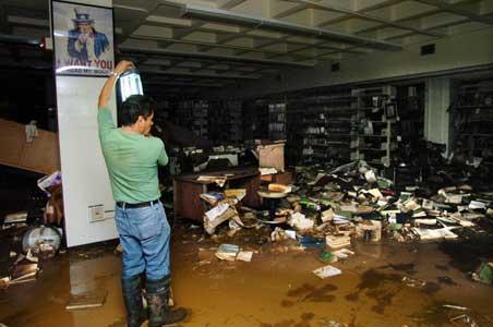
12 What s Wrong With This Picture Why Is My Flood Insurance So Expensive? Uninformed Flood Response Desperation Flood Proofing


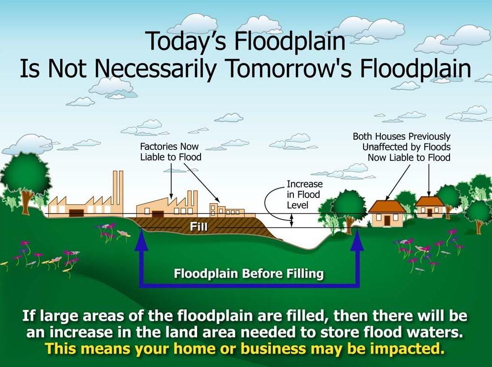
13 Then: 1944 Flood Control Act 1952 Council Bluffs Federal Levee Construction Now: Missouri River Levee Setback near State Hwy 2, Fremont County, IA Lower Flood Stages Lower Velocities More Resilient Reconnected Historic Floodplain Improved Environmental Benefits
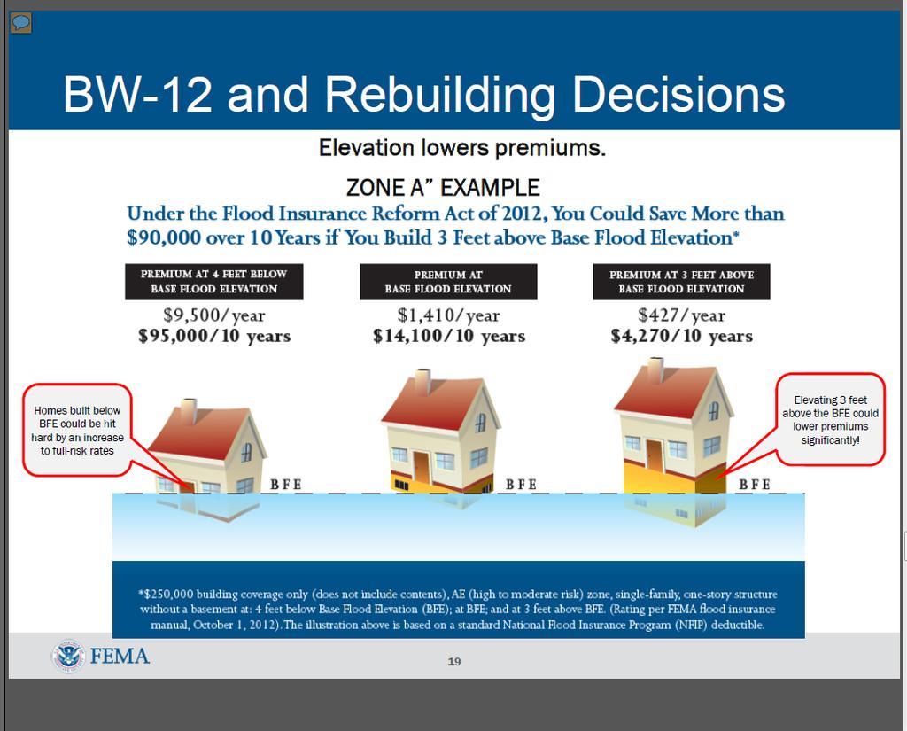
14 EO13690; Federal Flood Risk Management Standards Why Implement? $260Billion in flood damages between Amends EO11988 to incorporate higher standards for Federal actions Three approaches for establishing future Base Flood Elevation: 1. Use best-available data, incorporating actionable climate science 2. Build 2-feet above the 100-year flood elevation or 3-feet above for critical facilities 3. Build to the 500-year flood elevation EO13690 does not change requirements for: o o Flood Insurance FEMA levee accreditation EO13690 anticipated to have minimal impacts on: o o 404 permit process PL84-99 RIP program

15 , and, and more, OH MY! We re off to see the Wizard the Wizard of FRAM
16 Nonstructural Flood Risk Management Definition Nonstructural flood risk management can be categorized as a set of physical or nonphysical measures utilized for mitigating loss of life as well as existing and future flood damages. The physical measures adapt to the natural characteristics of the floodplain without adversely affecting or changing those natural flood characteristics. These measures are generally compliant with the NFIP and cause no adverse affects to the floodplain, flood stages, velocities, or the environment. Because of their ability to adapt to flood risk, these measures may also be referred to as Flood Risk Adaptive Measures (FRAM) and can be incorporated into existing or new structures to mitigate for potential future flood damages and life loss.
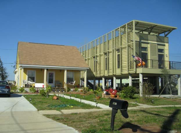
17 Nonstructural Flood Risk Adaptive Measures The most common physical Flood Risk Adaptive Measures implemented for flood damage and life loss reduction are: Acquisition Relocation Elevation Dry Flood Proofing Wet Flood Proofing Basement Removal Nonphysical measures can be considered separately or as a combination of floodplain management and planning functions. Representative nonphysical measures are: Floodplain Mapping Land Use Flood Insurance Evacuation Plans Flood Warning Zoning Operational Changes Emergency Preparedness Plans

18 Future Flood Risk Management (Resiliency, Redundancy, Sustainability)
19
20 * Caution Caution Caution * While nonstructural flood risk adaptive measures may result in lower property damages, there could be potential restrictions which the property owner needs to investigate prior to implementation: Local Ordinances State Regulations National Flood Insurance Program (NFIP) Note: Flood insurance is always recommended, even for structures which may have been retrofitted with nonstructural measures


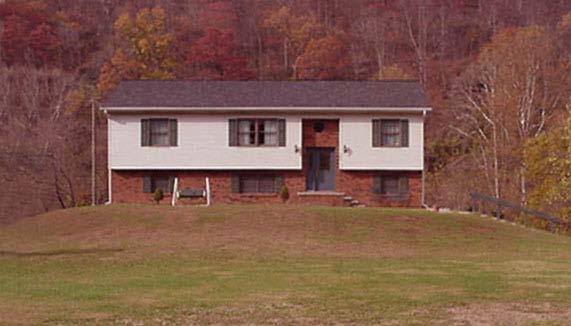
21 Nonstructural Flood Risk Adaptive Measures Elevation on Extended Foundation Walls Elevation with Structural Slab on Segmented Piles


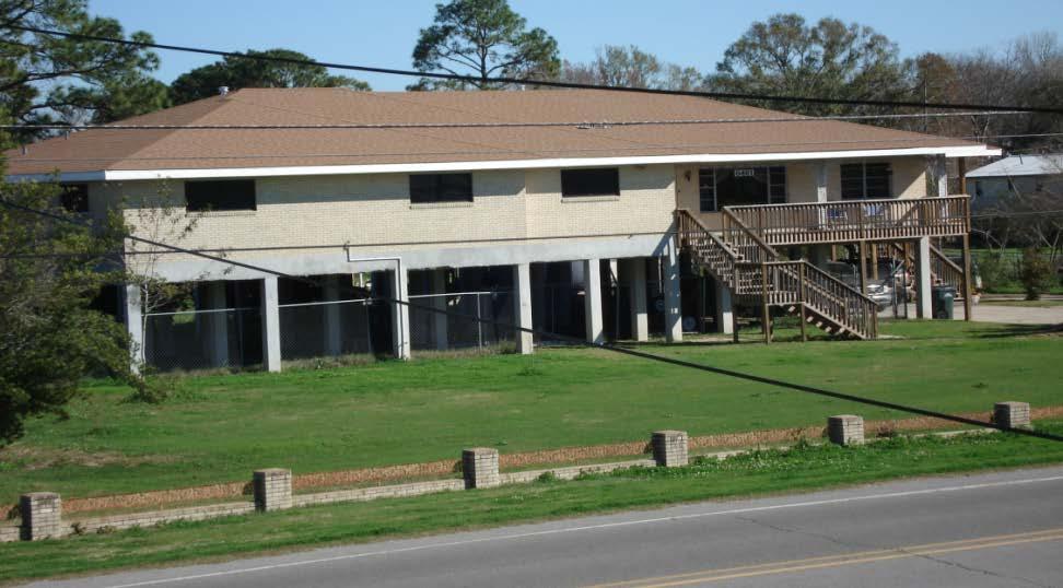
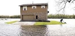
22 Elevation on Piers, Posts, Piles, or Columns
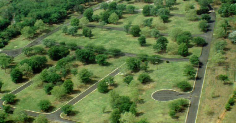
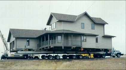
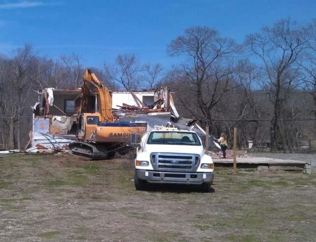
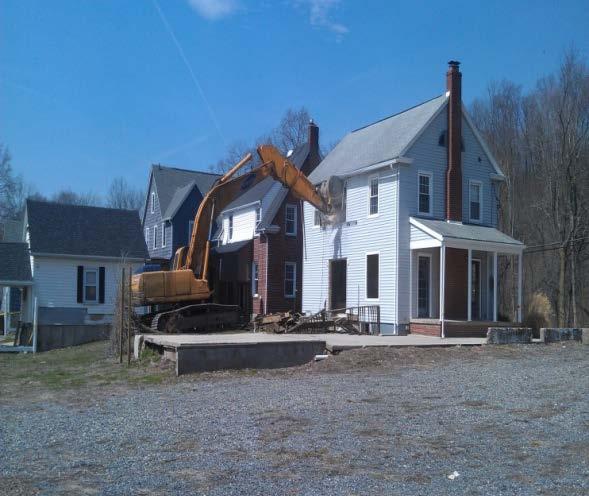
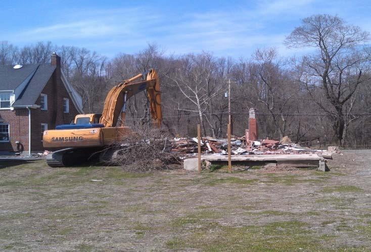
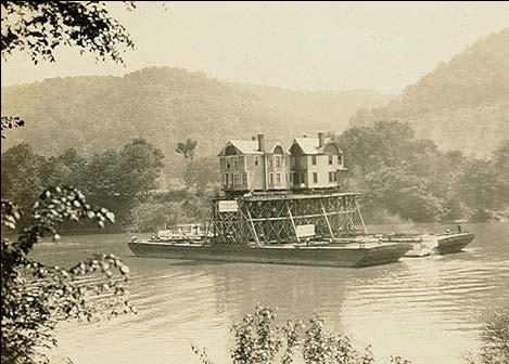
23 Nonstructural Flood Risk Adaptive Measures Relocation Acquisition


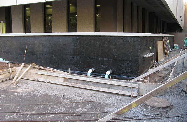

24 Dry Flood Proofing

25 Elevation on Fill


26 Elevation within a Historic Structure


, Historical")


27 Assessing the Situation Flood Characteristics Flood depth, Flood velocity, Flood duration, Rate of rise, Debris/Ice flows, Wave action, Floodway Encroachment Site Characteristics Location, Soil type, Topography, Parcel Size, Urban/Rural Building/Structure Characteristics Type of Construction, Foundation, Condition of the Building, Lower Levels (Basement), Historical Significance Other Considerations Building Occupancy, Building Codes, Zoning Ordinances and Local Restrictions, Other Agencies (Local / State / Federal), Aesthetics, Public Heath/Safety/Welfare

28 USACE National Nonstructural Flood Proofing Committee NFPC Members Randall Behm, Chair Kim Gavigan, Executive Secretary Steve O Leary Keven Lovetro Lea Adams Mary Weidel Bob Finch Brian Rast Technical Resources Publications Assessment Tools Barrier Testing Program Website Google: NFPC web site:


29 QUESTIONS? Randall L. Behm P.E., CFM (402)
IN THE LITTLE APPLE A PRESENTATION FOR THE 2017 ASFPM ANNUAL CONFERENCE IN KANSAS CITY, MO, MANAGING FLOOD RISK IN THE HEARTLAND
 A PRESENTATION FOR THE 2017 ASFPM ANNUAL CONFERENCE IN KANSAS CITY, MO, MANAGING FLOOD RISK IN THE HEARTLAND NONSTRUCTURAL 237 217 200 ASSESSMENT 80 252 237 217 200 119 174 237 217 200 27.59 IN THE LITTLE
Nonstructural Policy Clarification (PB )
") Nonstructural Policy Clarification (PB 2016-01) Jeremy LaDart Economist Office of Water Project Review Headquarters Maria Wegner Senior Policy Advisor Headquarters 3/17/2016 US Army Corps of Engineers
Nonstructural Policy Clarification (PB 2016-01) Jeremy LaDart Economist Office of Water Project Review Headquarters Maria Wegner Senior Policy Advisor Headquarters 3/17/2016 US Army Corps of Engineers
Upper Joachim Creek Public Survey on Potential Flood Risk Reduction
 Upper Joachim Creek Public Survey on Potential Flood Risk Reduction This survey is intended to help the interagency planning committee to receive public feedback on specific flood risk reduction techniques,
Flood Plain Management Services (FPMS) Program
 Program") Flood Plain Management Services (FPMS) Program 2016 Winter Stakeholder Partnering Forum March 2016 Mario Beddingfield, P.E., CFM Hydraulic Engineer/FPMS Program Manager H&H/Water Control Branch U.S. Army
Flood Plain Management Services (FPMS) Program 2016 Winter Stakeholder Partnering Forum March 2016 Mario Beddingfield, P.E., CFM Hydraulic Engineer/FPMS Program Manager H&H/Water Control Branch U.S. Army
Floodplain Management 101. Mississippi Emergency Management Agency Floodplain Management Bureau
 Floodplain Management 101 Mississippi Emergency Management Agency Floodplain Management Bureau Stafford Act The Stafford Disaster Relief and Emergency Assistance Act (Stafford Act) (Public Law 100-707)
Action Items for Flood Risk Management on Wildcat Creek Interagency success with floodplain management plans and flood forecast inundation maps
 Presentation to USACE 2012 Flood Risk Management and Silver Jackets Joint Workshop, Harrisburg, Pennsylvania Action Items for Flood Risk Management on Wildcat Creek Interagency success with floodplain
ADVISORY BASE FLOOD ELEVATIONS (ABFEs)
") The Department of Homeland Security s Federal Emergency Management Agency is committed to helping communities that were impacted by Hurricanes Katrina and Rita rebuild safer and stronger. Following catastrophic
The Department of Homeland Security s Federal Emergency Management Agency is committed to helping communities that were impacted by Hurricanes Katrina and Rita rebuild safer and stronger. Following catastrophic
National Institute of Building Sciences
 National Institute of Building Sciences Provider Number: G168 Improving the Flood Resistance of Buildings and Mitigation Techniques WE3B Peter Spanos, P.E., CFM, LEED AP (Gale Associates, Inc.) Stuart
Chapter 6 - Floodplains
 Chapter 6 - Floodplains 6.1 Overview The goal of floodplain management is to reduce the potential risks to both existing and future developments, and infrastructure, in the 100-year floodplain. Over the
DES MOINES CITY OF TWO RIVERS. Flooding Risk & Impact to Development
 DES MOINES CITY OF TWO RIVERS Flooding Risk & Impact to Development River System Des Moines Flood Protection Des Moines Flood Protection cont. Infrastructure Over 24 miles of levees 21stormwater pump stations
Association of State Floodplain Managers, Inc.
 Association of State Floodplain Managers, Inc. 2809 Fish Hatchery Road, Suite 204, Madison, WI 53713 Phone: 608-274-0123 Fax: 608-274-0696 Email: asfpm@floods.org Website: www.floods.org Critical Facilities
Situation: the need for non-structural flood risk reduction measures
 Evaluating benefits of non-structural measures in flood risk management feasibility studies At left: Example of a house on an open foundation Source Asheville, NC (undated) By Steve Cowdin, CFM; Natalie
Federal Emergency Management Agency
 Page 1 of 3 COMMUNITY AND MAP PANEL INFORMATION COMMUNITY CITY OF MARGATE CITY, ATLANTIC COUNTY, NEW JERSEY LEGAL PROPERTY DESCRIPTION A parcel of land, as described in Deed recorded in Book 4826, page
Requirements for Mapping Levees Complying with Section of the NFIP Regulations
 FACT SHEET Requirements for Mapping Levees Complying with Section 65.10 of the NFIP Regulations As part of a mapping project, it is the levee owner s or community s responsibility to provide data and documentation
Floodplain Management Annual Conference Atlanta, Georgia April 2017
 Floodplain Management 2017 Annual Conference Atlanta, Georgia April 2017 Floodplain Mapping and Flood Zones Zone Deisgnations: Zone A: No base flood elevations have been determined it is an approximated
Justification for Floodplain Regulatory Standards in Illinois
 Justification for Floodplain Regulatory Standards in Illinois Office of Water Resources Issue Paper April, 2015 Proactive Illinois floodplain and floodway regulatory standards have prevented billions of
Interagency Nonstructural Flood Risk Management Workshop. Carey Johnson Kentucky Division of Water
 Interagency Nonstructural Flood Risk Management Workshop Carey Johnson Kentucky Division of Water Nonstructural Flood Risk Management Nonstructural floodproofing Elevation Relocation Buyout/acquisition
Nonstructural Flood Proofing Committee Work Plan
 Nonstructural Flood Proofing Committee Work Plan 2018 2019 Overview The Nonstructural/Flood Proofing Committee is focused on promoting opportunities to work strategically across all levels of government
City of St. Augustine. Floodplain Management Higher Standards Information
 City of St. Augustine Floodplain Management Higher Standards Information There are different regulations that communities can use to help protect existing and future development and natural floodplain
Federal Flood Risk Management Standards. An Update on Federal Flood Resilience Standards
 Federal Flood Risk Management Standards An Update on Federal Flood Resilience Standards Purpose of Today s Briefing Facilitate the understanding of Executive Order (E.O.)13690 and its implementation Discuss
FREQUENTLY ASKED QUESTION ABOUT FLOODPLAINS Michigan Department of Environmental Quality
 FREQUENTLY ASKED QUESTION ABOUT FLOODPLAINS Michigan Department of Environmental Quality WHAT IS A FLOOD? The National Flood Insurance Program defines a flood as a general and temporary condition of partial
ENGINEERING AND CONSTRUCTION BULLETIN
 ENGINEERING AND CONSTRUCTION BULLETIN No. 2016-8 Issuing Office: CECW-CE Issued: 22 Feb 16 Expires: 22 Feb 18 SUBJECT: Interim Risk Reduction Measures (IRRMs) for Levee Safety CATEGORY: Directive and Policy
History of Floodplain Management in Ascension Parish
 History of Floodplain Management in Ascension Parish presented by: Kara Moree Floodplain Coordinator February 6, 2012 Floodplain 101 Floodplain 101 Base or 1% Flood: A flood having a 1% chance of being
Frequently Asked Questions Oxbow / Hickson / Bakke Ring Levee Option
 Frequently Asked Questions Oxbow / Hickson / Bakke Ring Levee Option October 16, 2012 Q1. Why has the position on a ring-levee changed? The feasibility study recommended buy-outs for areas with staging
Repetitive Loss Area Revisit # 6 Walter Road Area Jefferson Parish
 Repetitive Loss Area Revisit # 6 Walter Road Area Jefferson Parish www.floodhelp.uno.edu Supported by FEMA Acknowledgement The compilation if this report was managed by Erin Patton, CFM, a UNO-CHART Research
National Flood Insurance Program (NFIP) for Real Estate Professionals
 for Real Estate Professionals") National Flood Insurance Program (NFIP) for Real Estate Professionals 1 Joshua Oyer, CFM Outreach Specialist NFIP State Coordinator s Office at the Texas Water Development Board 2 Outline Introduction
National Flood Insurance Program (NFIP) for Real Estate Professionals 1 Joshua Oyer, CFM Outreach Specialist NFIP State Coordinator s Office at the Texas Water Development Board 2 Outline Introduction
University Drive Flood Risk Management Project Phase I 58 th Ave S to 500 S of 64 th Ave S City of Fargo Project FM-15-C1
 University Drive Flood Risk Management Project Phase I 58 th Ave S to 500 S of 64 th Ave S City of Fargo Project FM-15-C1 Public Informational Meeting October 15, 2015 6:00 P.M. Overview Flood Risk FEMA
Adaptation Practices and Lessons Learned
 Adaptation Practices and Lessons Learned Increased Flooding Risk Due To Sea Level Rise in Hampton Roads: A Forum to Address Concerns, Best Practices and Plans for Adaptation Nov. 16, 2012 Virginia Modeling,
Flood: How to Protect Your Business from a Natural Disaster
 Flood: How to Protect Your Business from a Natural Disaster Speakers: Greg Bates, Managing Consultant, Global Risk Consultants (GRC) Frank Francone, Manager, Insurance & Risk Services, General Growth Properties
Floodplain Development Permit Application
 Floodplain Development Permit Application **All construction will also require a building permit** This is an application packet for a Floodplain Development Permit. Certain sections are to be completed
Improving Coordinated Flood Preparedness and Response
 Improving Coordinated Flood Preparedness and Response Illinois Silver Jackets Hank DeHaan Rock Island and Saint Louis Districts October 2011 US Army Corps of Engineers Illinois Silver Jackets Program Illinois
Moving Policy and Practice from Flood and Coastal Storm Damage Reduction to Risk Management
 Moving Policy and Practice from Flood and Coastal Storm Damage Reduction to Risk Management and other words of encouragement for my friends in the Planning CoP Eric Halpin, PE Special Assistant for Dam
Authors: Terry Zien, Brian Rast and the Silver Jackets Co presenters: Brian Rast, Dave Lupardus and Frank Dolan
 Authors: Terry Zien, Brian Rast and the Silver Jackets Co presenters: Brian Rast, Dave Lupardus and Frank Dolan http://www.mvp.usace.army.mil/missions/civilworks/floodriskm anagement/emergencyactionplanguidebook.aspx
Wetzel County Floodplain Ordinance
 Wetzel County Floodplain Ordinance AUTHORITY AND PURPOSE: THE PROVISIONS OF THIS ORDINANCE HAVE BEEN PREPARED WITH THE INTENTION OF MEETING THE REQUIREMENTS OF SECTION 60.3 (D) OF THE NATIONAL FLOOD INSURANCE
Presented by: Connie Perkins, PE, CFM April 20, 2016
 Presented by: Connie Perkins, PE, CFM April 20, 2016 City of Sacramento s Flood History Need for a Comprehensive Flood Management Plan (CFMP) Overview of Sacramento s CFMP 2016 Next Steps Sacramento
CHAPTER 160 FLOOD PLAIN REGULATIONS
 CHAPTER 160 FLOOD PLAIN REGULATIONS 160.01 Statutory Authority 160.13 Special Shallow Flooding Areas Standards 160.02 Findings of Fact 160.14 Administration 160.03 Purpose 160.15 Flood Plain Development
1. STATUTORY AUTHORIZATION, FINDINGS OF FACT, AND PURPOSES... 2
 ORDINANCE NO. 15-03 CAPE GIRARDEAU COUNTY FLOODPLAIN MANAGEMENT ORDINANCE ARTICLE # PAGE # 1. STATUTORY AUTHORIZATION, FINDINGS OF FACT, AND PURPOSES... 2 2. GENERAL PROVISIONS... 3 3. ADMINISTRATION...
Appendix P Non-Structural
 Appendix P Non-Structural Fargo-Moorhead Metropolitan Area Flood Risk Management Final Feasibility Report and Environmental Impact Statement July 2011 Prepared by: U.S. Army Corps of Engineers St. Paul
Risk Assessment Framework. Levee Ready Columbia
 Risk Assessment Framework Levee Ready Columbia November 23, 2015 Today s Discussion Level of Protection Levees and Risk Tolerable Risk Guidelines Applying Tolerable Risk Guidelines Levees and Level of
MT-1 Basics: A Comprehensive Overview of LOMAs and Discussion of Common Application Setbacks
 MT-1 Basics: A Comprehensive Overview of LOMAs and Discussion of Common Application Setbacks Introduction: Terminology MT-1s vs. MT-2s LOMAs vs. LOMRs What is a LOMC? Letters of Map Change (LOMCs) MT-1s
Community Rating System. National Flood Insurance Program
 National Flood Insurance Program Community Rating System A Local Official s Guide to Saving Lives Preventing Property Damage Reducing the Cost of Flood Insurance FEMA B-573 / May 2015 How the Community
U.S. Army Corp of Engineers
 U.S. Army Corp of Engineers PL 84-99 Levee Inspections and Levee Certification Hank DeHaan Rock Island District March 9, 2011 US Army Corps of Engineers U.S. Army Corps of Engineers Flood Damage Reduction
Passaic River Basin Flood Advisory Commission Report/Status of Recommendations. October 2014 Update
 Passaic River Basin Flood Advisory Commission Report/Status of Recommendations October 2014 Update Passaic River Basin Flood Advisory Commission April 2010: By Executive Order, Governor Christie created
Public Information Meeting Rahway River Basin, New Jersey Flood Risk Management Feasibility Study
 Public Information Meeting Rahway River Basin, New Jersey Flood Risk Management Feasibility Study U.S. Army Corps of Engineers, New York District New Jersey Department of Environmental Protection 11 &
National Flood Insurance Program (NFIP) and Flood Insurance Rate Map (FIRM) San Francisco Port Commission. October 23, 2007
 and Flood Insurance Rate Map (FIRM) San Francisco Port Commission. October 23, 2007") National Flood Insurance Program (NFIP) and Flood Insurance Rate Map (FIRM) San Francisco Port Commission October 23, 2007 Flood Insurance Rate Map (FIRM) FEMA manages the NFIP using a nationwide system
National Flood Insurance Program (NFIP) and Flood Insurance Rate Map (FIRM) San Francisco Port Commission October 23, 2007 Flood Insurance Rate Map (FIRM) FEMA manages the NFIP using a nationwide system
Levee Safety The Middle Age Of Levee Safety Development
 Levee Safety The Middle Age Of Levee Safety Development HDR Showcase Panel Discussion June 22, 2016 Living the Current Changing Regulatory Climate by Roger Less, PE, CFM Overview of Section 408 Permit
Levees: PL84-99 and the NFIP
 Levees: PL84-99 and the NFIP Tony D. Krause, P.E., CFM Flood Risk and Floodplain Management Omaha District US Army Corps of Engineers Objectives and Overview Objectives: Identify overlaps between Federal
Floodplain Development Permit Application
 Floodplain Development Permit Application City of Jonesboro, AR This is an application packet for a Floodplain Development Permit. Certain sections are to be completed by the Applicant, and certain sections
Flood Resistant Provisions of Connecticut s Newest Building Codes. Laura E. Ghorbi, PE, CFM Risk Management & Resilience
 Flood Resistant Provisions of Connecticut s Newest Building Codes Laura E. Ghorbi, PE, CFM Risk Management & Resilience October 25, 2017 Overview 2018 Connecticut State Building Code Adoption National
Chapter 7 Appendix B: National Flood Insurance Program Summary for Kaua'i County, 2015 Update
 Chapter 7 Appendix B: National Flood Insurance Program Summary for Kaua'i County, 2015 Update Topic Considerations Description INSURANCE SUMMARY STAFF RESOURCES How many NFIP policies are in Kaua i County?
Flood Risk and Climate Adaptation: Policy Reforms and Lessons (Being) Learned from Hurricane Sandy
 Learned from Hurricane Sandy") Flood Risk and Climate Adaptation: Policy Reforms and Lessons (Being) Learned from Hurricane Sandy Adaptive Planning For Coastal Change: Legal Issues For Local Government Briefing Overview 2 Background:
Flood Risk and Climate Adaptation: Policy Reforms and Lessons (Being) Learned from Hurricane Sandy Adaptive Planning For Coastal Change: Legal Issues For Local Government Briefing Overview 2 Background:
ORDINANCE NO. ALLAMAKEE COUNTY FLOODPLAIN MANAGEMENT REGULATION
 ORDINANCE NO. AN ORDINANCE APPROVING AND ADOPTING APPROPRIATE LAND USE AND CONTROL MEASURES TO REDUCE FUTURE FLOOD LOSSES IN ALLAMAKEE COUNTY, IOWA IN A MANNER THAT WILL ALLOW THE COUNTY TO PARTICIPATE
Community Incentives for Nature-Based Flood Solutions
 Community Incentives for Nature-Based Flood Solutions A GUIDE TO FEMA S COMMUNITY RATING SYSTEM FOR CONSERVATION PRACTITIONERS The Federal Emergency Management Agency (FEMA) uses a Community Rating System
10526 Bermuda Isle Dr. Tampa, FL 33647
 Flood Analysis Memo Property Address In Partnership with: ** This property is NOT within a high-risk flood zone ** This property is located in a FEMA low-risk zone designated as Zone X - an area of minimal
Community Resilience & NFIP s Community Rating system
 Community Resilience & NFIP s Community Rating system Ajita Atreya Wharton Risk Management and Decision Processes Center University of Pennsylvania National Association of Counties (NACo) Session on Risk
TOWN OF KENT, CT PLANNING AND ZONING COMMISSION
 TOWN OF KENT, CT PLANNING AND ZONING COMMISSION FLOOD PLAIN MANAGEMENT REGULATIONS Whereas, Congress has determined that a National Flood Insurance Program would alleviate personal hardships and economic
Piloting LAMP from Stream to Sea
 Piloting LAMP from Stream to Sea FEMA s New Analysis and Mapping Procedures for Non-Accredited Levee Systems Presented by: Eric Simmons, CFM Senior Engineer, FEMA Region IX Presentation Outline Levee Issues
Living with levees: using tolerable risk guidelines in California
 Living with levees: using tolerable risk guidelines in California Jessica Ludy, CFM. Arcadis-U.S. Inc. Larry Roth, G.E., P.E., Arcadis-US, Inc. Dustin Jones, P.E., Delta Stewardship Council 1 Hoogwater
Floodplain Management Assessment
 CHEHALIS RIVER BASIN Floodplain Management Assessment Master Report Final April, 2015 TABLE OF CONTENTS Executive Summary... 1 Introduction... 2 The Floodplain... 4 Floodplain Development... 4 Floodplain
Community Development Department
 Community Development Department Ryan DeVore, Interim Director of Community Development Scot Mende, Principal Planner Bill Busath, Interim Director of Utilities Connie Perkins, Senior Engineer, Floodplain
NONSTRUCTURAL FLOOD RISK MANAGEMENT ECONOMIC ASSESSMENT FOR LYCOMING COUNTY LYCOMING COUNTY, PENNSYLVANIA
 NONSTRUCTURAL FLOOD RISK MANAGEMENT ECONOMIC ASSESSMENT FOR LYCOMING COUNTY LYCOMING COUNTY, PENNSYLVANIA Study requested by: Study supported by: Study led by: Lycoming County 330 Pine Street Williamsport,
Flood Vulnerability Assessment for Critical Facilities. Molly Woloszyn Lisa Graff, GISP, CFM
 Flood Vulnerability Assessment for Critical Facilities Molly Woloszyn Lisa Graff, GISP, CFM 2011 University of Illinois Board of Trustees. All rights reserved. For permission information, contact the Illinois
Executive Summary Levee Engineering Assessments September 26, 2014
 Executive Summary s September 26, 2014 Purpose Multnomah County Drainage District (MCDD), the agency responsible for managing the Columbia Corridor levee system, received notification that in August of
FEMA FLOOD MAPS Public Works Department Stormwater Management Division March 6, 2018
 FEMA FLOOD MAPS Public Works Department Stormwater Management Division March 6, 2018 Presentation Overview FEMA National Flood Insurance Program (NFIP) FEMA Community Rating System (CRS) Flood Insurance
Disaster Insurance: Are States and Insurance Companies Prepared?
 Disaster Insurance: Are States and Insurance Companies Prepared? National Conference of State Legislatures 2015 Legislative Summit Roy Wright Deputy Associate Administrator for Insurance and Mitigation
Floodplain Management Plan
 Floodplain Management Plan CITY OF FORT WORTH TFMA 2016 Spring Conference March 10, 2016 Agenda 1. Fort Worth Higher Standards (NFIP & CRS) 2. Floodplain Management Plan Overview and Results 3. Project
10526 Bermuda Isle Dr. Tampa, FL 33647
 Flood Analysis Memo Property Address 10526 Bermuda Isle Dr. In Partnership with: ** This property is NOT within a high-risk flood zone ** 10526 Bermuda Isle Dr. BFE = 35 ft This property is located in
FLOODPLAIN MANAGEMENT: A PRESENT AND A 21st CENTURY IMPERATIVE. Gerald E. Galloway, Jr. United States Military Academy
 FLOODPLAIN MANAGEMENT: A PRESENT AND A 21st CENTURY IMPERATIVE Gerald E. Galloway, Jr. United States Military Academy Introduction The principal rivers of the United States and their tributaries have played
HAZARD MITIGATION IN HISTORIC DISTRICTS. Louisette L. Scott AICP, CFM Director, Dept. Planning & Development Mandeville, LA January 31, 2018
 1 HAZARD MITIGATION IN HISTORIC DISTRICTS Louisette L. Scott AICP, CFM Director, Dept. Planning & Development Mandeville, LA January 31, 2018 Mandeville, LA 2 Mandeville is Located on the northshore of
The National Flood Insurance Program and Flood Insurance Rate Map for San Francisco. Presentation at Treasure Island Community Meeting
 The National Flood Insurance Program and Flood Insurance Rate Map for San Francisco Presentation at Treasure Island Community Meeting October 17, 2007 1 National Flood Insurance Program (NFIP) Overview
Article 23-6 FLOODPLAIN DISTRICT
 AMENDING THE CODE OF THE CITY OF PITTSFIELD CHAPTER 23, ZONING ORDINANCE SECTION I That the Code of the City of Pittsfield, Chapter 23, Article 23-6 Floodplain District, shall be replaced with the following:
ECONOMIC EVALUATION OF FLOODPLAIN MANAGEMENT AND FLOOD MITIGATION
 ECONOMIC EVALUATION OF FLOODPLAIN MANAGEMENT AND FLOOD MITIGATION CITY OF BIRMINGHAM, ALABAMA EDWIN REVELL, CFM FLOOD PLAIN ADMINISTRATOR DENISE PRUITT, CFM PROJECT PLANNER PRESENTATION OUTLINE 1. BACKGROUND/LOCATION
a) Ensure public safety through reducing the threats to life and personal injury.
 Ensure public safety through reducing the threats to life and personal injury.") SECTION VII: FLOODPLAIN DISTRICT 7-1 Statement Of Purpose The purposes of the Floodplain District are to: a) Ensure public safety through reducing the threats to life and personal injury. b) Eliminate
SECTION VII: FLOODPLAIN DISTRICT 7-1 Statement Of Purpose The purposes of the Floodplain District are to: a) Ensure public safety through reducing the threats to life and personal injury. b) Eliminate
Memorandum. November 11,2010. Trinity River Corridor Project Committee Members: David
 Memorandum DATE November 11,2010 CITY OF DALLAS TO Trinity River Corridor Project Committee Members: David A. Neumann (Chairman) Vonciel Jones Steve Salazar (Vice-Chair) Delia Mayor Pro Tern Dwaine Caraway
Erie County Flood Risk Review Meeting. January 18, 2018
 Erie County Flood Risk Review Meeting January 18, 2018 Agenda The value of updated flood maps for your community Review updated flood-risk data and important next steps in the Risk MAP process Increasing
*How Federal Policy. Causes Flood Disasters. Leslie A. Bond, CFM LA Bond Associates
 *How Federal Policy Causes Flood Disasters Leslie A. Bond, CFM LA Bond Associates *The high cost of flood disasters *We do not know what floods cost. *Published estimates do not include all costs of disasters.
Vocabulary of Flood Risk Management Terms
 USACE INSTITUTE FOR WATER RESOURCES Vocabulary of Flood Risk Management Terms Appendix A Leonard Shabman, Paul Scodari, Douglas Woolley, and Carolyn Kousky May 2014 2014-R-02 This is an appendix to: L.
Findings/Debrief Meeting September 9, CDOT R4 Headquarters Big Thompson Conference Room W 10 th St. Greeley, CO 80634
 Findings/Debrief Meeting September 9, 2016 CDOT R4 Headquarters Big Thompson Conference Room 10601 W 10 th St. Greeley, CO 80634 Discovery Review & Outcome May 25 Discovery Meeting Summary Summarize Data
National Flood Insurance Program
 National Flood Insurance Program A Discussion in Three Parts: The Nature of Flood Risk An Overview of the NFIP Impact of Recent Legislation (BW-12 & HFIAA-14) Nature of Flood Risk FLOODS ARE AN ACT OF
Reconstruction Implications
 Federal Emergency Management Agency (FEMA) Recovery Guidance Advisory Base Flood Elevation (ABFE) of April 12, 2006 Reconstruction Implications Presentation to: City of New Orleans July 6 th, 2006 Lambert
2011 MT Floods Damages and Recovery Options
 MONTANA 2011 MT Floods Damages and Recovery Options Damage Estimates Public Works: Between $57.5 million Individual: id Housing Assistance $4,442,194 Small Business Assistance $1,634,100 Other Needs
Integrating Hazard Mitigation and Comprehensive Planning Workshop
 Delaware Valley Regional Planning Commission Philadelphia, PA April 25, 2016 12:30 p.m. Integrating Hazard Mitigation and Comprehensive Planning Workshop Stephen D. Marks Municipal Manager City of Hoboken,
Flooding Part One: BE Informed. Department of Planning & Development
 Flooding Part One: BE Informed Department of Planning & Development Introduction The residents of the City of Noblesville enjoy many benefits from being located on the banks of the White River. These benefits
This survey is expected to take approximately 20 minutes and must be completed in one session.
 State Flood Assessment Survey 1 Introduction Thank you for your willingness to participate in this online survey as part of the State Flood Assessment effort. This first step toward developing comprehensive
Coastal Flood Maps. Chris Penney. Program Manager USACE Baltimore District 2 June US Army Corps of Engineers BUILDING STRONG
 Coastal Flood Maps Chris Penney Program Manager USACE Baltimore District 2 June 2015 US Army Corps of Engineers There are two types of coastal flood risk maps They look different They communicate different
CITIZEN POTAWATOMI NATION PUBLIC CONSERVATION AND ENVIROMENTAL PROTECTION ACT TITLE 35
 CITIZEN POTAWATOMI NATION PUBLIC CONSERVATION AND ENVIROMENTAL PROTECTION ACT TITLE 35 CHAPTER SECTION 1 ESTABLISHMENT OF THE DEPARTMENT OF ENVIRONMENTAL PROTECTION Establishment 101 Required Reporting
This survey is expected to take approximately 20 minutes and must be completed in one session.
 Introduction Thank you for your willingness to participate in this online survey as part of the State Flood Assessment effort. This first step toward developing comprehensive flood planning for Texas does
Introduction to the National Flood Insurance Program: A Guide for Coastal Property Owners MAINE BEACHES CONFERENCE 2017
 Introduction to the National Flood Insurance Program: A Guide for Coastal Property Owners MAINE BEACHES CONFERENCE 2017 SUE BAKER, CFM STATE NFIP COORDINATOR MAINE DEPT OF AGRICULTURE, CONSERVATION & FORESTRY
9/20/2016. Orange County Preliminary FIRM / Consultation Coordination Officer (CCO) Meeting
 Meeting") Orange County Preliminary FIRM / Consultation Coordination Officer (CCO) Meeting Open Pacific Coast Study September 21 and 22, 2016 1 Welcome and Introductions Preliminary FIRM / CCO Meeting Orange County
Orange County Preliminary FIRM / Consultation Coordination Officer (CCO) Meeting Open Pacific Coast Study September 21 and 22, 2016 1 Welcome and Introductions Preliminary FIRM / CCO Meeting Orange County
Silver Jackets - Flood Risk Management Program
 COOPERATING TECHNICAL PARTNER INFORMATION EXCHANGE Silver Jackets - Flood Risk Management Program August 31, 2017 Association of State Floodplain Managers AUDIO AND WEB SETTINGS Your Participation Open
Using GISWeb to Determine Your Property s Flood Zone
 Using GISWeb to Determine Your Property s Flood Zone 1. In a new browser window, go to http://www.co.santacruz.ca.us/departments/geographicinformationsystemsgis.aspx 2. Click on GISWeb - GIS Mapping Application
FLOOD PLAIN DEVELOPMENT ORDINANCE
 FLOOD PLAIN DEVELOPMENT ORDINANCE DES MOINES COUNTY, IOWA ORDINANCE NO. 25 Adopted July 19, 1993 Amended July 26, 1993 Amended January 3, 1995 Amended August 7, 2011 Amended October 16, 2015 TABLE OF CONTENTS
HENRY COUNTY, OHIO SPECIAL PURPOSE FLOOD DAMAGE PREVENTION REGULATIONS TABLE OF CONTENTS
 HENRY COUNTY, OHIO SPECIAL PURPOSE FLOOD DAMAGE PREVENTION REGULATIONS TABLE OF CONTENTS TABLE OF CONTENTS... i-ii SECTION 1.0 STATUTORY AUTHORIZATION, FINDINGS OF FACT PURPOSE AND OBJECTIVES 1.1 STATUTORY
City of Santa Clarita Engineering Services Division Valencia Boulevard Santa Clarita, CA (661) Levee Certification
 Levee Certification") City of Santa Clarita Engineering Services Division 23920 Valencia Boulevard Santa Clarita, CA 91355 (661) 255-4942 Levee Certification FEMA is currently updating the nation s flood hazard maps under a
City of Santa Clarita Engineering Services Division 23920 Valencia Boulevard Santa Clarita, CA 91355 (661) 255-4942 Levee Certification FEMA is currently updating the nation s flood hazard maps under a
THE ECONOMIC ARGUMENT FOR AMPHIBIOUS RETROFIT CONSTRUCTION
 THE ECONOMIC ARGUMENT FOR AMPHIBIOUS RETROFIT CONSTRUCTION Elizabeth C. English Ph.D., A.M. ASCE Associate Professor School of Architecture University of Waterloo WHAT IS AMPHIBIOUS ARCHITECTURE? Amphibious
July 31, 2017 NFIP Flood Map Open House Flood Maps 101 Flood Mapping acronyms History of the NFIP Flood Mapping Updates Flood Insurance Fairhope,
 July 31, 2017 NFIP Flood Map Open House Flood Maps 101 Flood Mapping acronyms History of the NFIP Flood Mapping Updates Flood Insurance Fairhope, Alabama Flood Maps Fairhope Permitting Jurisdiction Coastal
Dealing With Unnumbered A Zones in Maine Floodplain Management
 Dealing With Unnumbered A Zones in Maine Floodplain Management The following is a list of acceptable methods that the State Floodplain Management Coordinator and the Federal Emergency Management Agency
COMMUNITY CERTIFICATIONS
 OMB No. xxxxxxxx Expires: xxxxxxxx National Flood Insurance Program Community Rating System COMMUNITY CERTIFICATIONS D R A F T CRS COMMUNITY CERTIFICATIONS The following community certifications are part
Ocean City Office of Emergency Management. Environmental Commission Lecture Series October 24, 2017
 Ocean City Office of Emergency Management Environmental Commission Lecture Series October 24, 2017 FEMA Region II Flood Insurance Rate Maps (FIRM s) Adopted as of 10/5/2017 All of Cape May County adopted
Pre-Development Floodplain Application
 Pre-Development Floodplain Application The Department of Planning, at the recommendation of FEMA, is now requiring completion of a Pre- Development Floodplain Application for all properties in the regulated