NONSTRUCTURAL FLOOD RISK MANAGEMENT ECONOMIC ASSESSMENT FOR LYCOMING COUNTY LYCOMING COUNTY, PENNSYLVANIA
|
|
|
- Earl Osborne
- 5 years ago
- Views:
Transcription


1 NONSTRUCTURAL FLOOD RISK MANAGEMENT ECONOMIC ASSESSMENT FOR LYCOMING COUNTY LYCOMING COUNTY, PENNSYLVANIA Study requested by: Study supported by: Study led by: Lycoming County 330 Pine Street Williamsport, Pennsylvania Pennsylvania Silver Jackets Team Planning Division U.S. Army Corps of Engineers, Baltimore District P.O. Box 1715 Baltimore, Maryland APRIL 2016
2
3 NONSTRUCTURAL FLOOD RISK MANAGEMENT ECONOMIC ASSESSMENT FOR LYCOMING COUNTY Lycoming County, Pennsylvania Prepared for: Lycoming County Planning and Community Development 330 Pine Street Williamsport, Pennsylvania Prepared by: Planning Division U.S. Army Corps of Engineers, Baltimore District P.O. Box 1715 Baltimore, Maryland MAY 2016
4
5 TABLE OF CONTENTS 1 INTRODUCTION PURPOSE OF STUDY STUDY AREA BACKGROUND COORDINATION BUILDING ELEVATION SURVEYS NONSTRUCTURAL FLOODPROOFING EVALUATION ECONOMIC ANALYSES FLOOD INSURANCE PREMIUM BENEFIT-COST ANALYSIS DAMAGES PREVENTED BENEFIT-COST ANALYSIS CONCLUSIONS REFERENCES LIST OF FIGURES Figure 1-1 Location of Lycoming County Within Pennsylvania Figure 1-2 Map of Study Area Figure 2-1 Building Elevation Survey Point Types Figure 2-2 Map of Surveyed Properties in Muncy Borough Figure 3-1 Locations of Nonstructural Analyses Conducted in Muncy Borough Figure 3-2 Locations of Nonstructural Analyses Conducted in Jersey Shore Borough Figure 3-3 Locations of Nonstructural Analyses Conducted in Old Lycoming Township LIST OF TABLES Table 2-1 Property Addresses for Building Elevation Surveys Table 3-1 Property Addresses of s Table 3-2 Nonstructural Mitigation Estimated Costs Table 4-1 Key Descriptive Characteristics of the Four Sample Structures Table 4-2 Insurance Premium Reduction Benefits for Four Sample Structures Table 4-3 Nonstructural Mitigation Costs Table 4-4 Long-Term Cost of Flood Insurance with and without Implementation of Nonstructural Mitigation Options Table 4-5 Capital Recovery Factors (CRF) Used for Animalization of Costs Over Various Time Periods Nonstructural Flood Risk Management Economic Assessment for Lycoming County April 2016 TOC- i
6 Table 4-6 Insurance Benefit-Cost Ratios for the Sample Structures Based on Different Time Periods Table 4-7 Expected Annual Benefits ($) from Damages Avoided Table 4-8 Damages Avoided Benefit-Cost Ratios for the Sample Structures Based on Different Time Periods Appendix A: Appendix B: Economic Analysis APPENDICES Nonstructural Flood Risk Management Economic Assessment for Lycoming County April 2016 TOC- ii
7 1 INTRODUCTION 1.1 PURPOSE OF STUDY Lycoming County, Pennsylvania consists of over 2,200 miles of streams. Land use and floodplain regulations were not yet in place when most settlements were established, so many structures were built in areas with high risk for flood damages. Many structures are located within the regulated floodplain and flood insurance premiums for residents and business owners in the County are expected to rise significantly due to recent changes in legislation (the Biggert- Waters Flood Insurance Reform and Modernization Act of 2012 and the Homeowner Flood Insurance Affordability Act of 2014). With these legislative changes, primary residential properties currently receiving subsidized flood insurance premiums will receive incrementally higher premiums each year. The County has received a grant from the Pennsylvania Housing Affordability and Rehabilitation Enhancement program, and intends to use these funds to assist in implementation of nonstructural flood risk mitigation projects to help reduce the flood risk and flood insurance premiums. As part of this effort, the County requested the assistance of the Pennsylvania Silver Jackets Interagency Flood Risk Management Team to assess the potential for nonstructural mitigation activities for structures located between the 2% annual chance floodplain (50-year floodplain) and 0.2% annual chance floodplain (500-year floodplain) in three high-risk communities. To assess the potential for nonstructural mitigation activities, six tasks were completed: 1) conduct building elevation surveys; 2) perform nonstructural floodproofing assessments for prototypical structures; 3) develop preliminary costs for constructing the nonstructural measures; 4) develop a cost matrix database; 5) perform a cost-benefit analysis to determine the cost-effectiveness of mitigation; and 6) participate in outreach efforts. The information developed through these tasks will assist with prioritization of future flood risk management efforts and implementation of nonstructural mitigation projects. 1.2 STUDY AREA The highest risk communities in the County include: Jersey Shore Borough, Muncy Borough, and Old Lycoming Township. The location of Lycoming County within Pennsylvania is shown in Figure 1-1. The study area includes the three communities shown in Figure 1-2. Nonstructural Flood Risk Management Economic Assessment for Lycoming County April

8 FIGURE 1-1 LOCATION OF LYCOMING COUNTY WITHIN PENNSYLVANIA Nonstructural Flood Risk Management Economic Assessment for Lycoming County April
9 FIGURE 1-2 MAP OF STUDY AREA Nonstructural Flood Risk Management Economic Assessment for Lycoming County April
10 1.3 BACKGROUND Lycoming County includes many residential areas at risk of flood damage. Within the County, ten percent of the structures are located within the regulatory floodplain, 528 are repetitive loss structures, and 30 are severe repetitive loss structures. In the three municipalities studied, Jersey Shore Borough, Muncy Borough, and Old Lycoming Township, nearly 50% of homes are in the floodplain. The County has previously worked to acquire many of the most vulnerable structures, and now looks to consider nonstructural mitigation alternatives for the remaining atrisk structures. This project was selected and funded as an interagency Silver Jackets project. The Silver Jackets program is designed to bring together a team of federal, state, and local agencies to address flood risk management challenges identified by the state. The interagency projects developed and funded through the Silver Jackets program are intended to be small projects, which do not include any construction, to address specific flood risk management challenges and develop solutions to reduce flood risk through interagency collaboration. All state teams have the opportunity to submit proposals for consideration, and proposals are selected for funding based on the amount of funding available. United States Army Corps of Engineers (USACE) participation on these interagency projects is provided from the Floodplain Management Services Program (FPMS), which is leveraged against resources from interagency partners in the form of additional funds or work-in-kind. For this project, Lycoming County voluntarily contributed non-federal funds for use in economic and cost-benefit analyses. The County identified 112 structures for USACE to survey in Muncy Borough (recent elevation survey data already existed for structures in Jersey Shore Borough and Old Lycoming Township so surveys were not done in these communities). The County selected 19 prototype buildings throughout the three communities in the study area to be assessed for nonstructural floodproofing measures and provided USACE with the data necessary to perform the analysis for each structure. Based on the data collected from the site visits, nonstructural floodproofing concepts and preliminary cost estimates were completed for each of the 19 prototype structures. Cost-benefit analyses were conducted to determine the viability of the nonstructural floodproofing alternatives. 1.4 COORDINATION USACE s role in this project is part of a larger interagency effort shared by other agencies through the Pennsylvania Silver Jackets team. Contributing partners included the Federal Emergency Management Agency, the Susquehanna River Basin Commission, the Pennsylvania Emergency Management Agency, and Lycoming County. Nonstructural Flood Risk Management Economic Assessment for Lycoming County April
11 2 BUILDING ELEVATION SURVEYS A list of residential and commercial structures in Muncy Borough was provided by Lycoming County for the elevation surveys. USACE surveyed these properties in April Elevation measurements were taken at the lowest adjacent grade (LAG) to assist in identifying the elevation at which the start of damages to the structure could occur; the lowest opening (LO) to identify the elevation at which flood waters could enter the structure and cause damage to the contents within the structure; and at the first floor (FF), which is the first enclosed level of the structure representing livable space subject to property damage/loss (Figure 2-1). Elevations were determined using a Trimble TM Real Time Kinematic (RTK) Global Positioning System (GPS) hardware device, with vertical elevations accurate to approximately 20 millimeters and referenced in NAVD88 (Trimble, 2012a). USACE utilized standard differential leveling and/or other surveying techniques where tree/building cover obstructed the RTK signal. Trimble TM Yuma GPS tablet recorded geographic location in longitude and latitude. The Yuma tablet GPS function is accurate to approximately 2-5 meters (Trimble, 2012b). A Microsoft Office Access database was developed to inventory each structure and its associated data (Microsoft, 2006). The data collected for each structure included the following: date inventoried, staff, latitude/longitude, street address, primary structure use (e.g., commercial, residential, or other), structure type (e.g., detached, duplex, townhouse), structure condition (e.g., good, fair, poor), basement (e.g., yes/no and type (e.g., no access, below grade, walkout)), crawlspace or slab on grade, lowest adjacent grade elevation, low opening type (e.g., door, window, vent, other), low opening elevation, first floor elevation, digital pictures, and comments. This information is also provided in Global Information System (GIS) shapefiles. The project disc provided with this report includes digital pictures of each building surveyed. USACE completed elevation surveys for 112 structures within Muncy Borough. Figure 2-2 shows the location of each surveyed building, and Table 2-1 lists the addresses. Building elevation data and structure location GIS shapefiles are provided on the accompanying project disc. Nonstructural Flood Risk Management Economic Assessment for Lycoming County April

12 FIGURE 2-1 BUILDING ELEVATION SURVEY POINT TYPES Low opening Lowest adjacent grade First floor Lowest adjacent grade in this example is the front left corner, the lowest point the water would reach the structure. Low opening in this example is the basement window, where water would first enter the building. First floor opening here is the front door entrance into the main floor, where the most damage would typically occur if floodwaters reached this elevation. Nonstructural Flood Risk Management Economic Assessment for Lycoming County April

13 FIGURE 2-2 MAP OF SURVEYED PROPERTIES IN MUNCY BOROUGH Nonstructural Flood Risk Management Economic Assessment for Lycoming County April
14 TABLE 2-1 PROPERTY ADDRESSES FOR BUILDING ELEVATION SURVEYS Street Address Street Address Street Address Street Address 503 Allegheny St 151 Carpenter St 151 E Water St 44 Green St 508 Allegheny St 153 Carpenter St 152 E Water St 46 Green St 512 Allegheny St 155 Carpenter St 153 E Water St 47 Green St 513 Allegheny St 157 Carpenter St 154 E Water St 48 Green St 516 Allegheny St 15 E Water St 155 E Water St 50 Green St 517 Allegheny St 124 E Water St 156 E Water St 51 Green St 520 Allegheny St 126 E Water St 157 E Water St 52 Green St 521 Allegheny St 128 E Water St 158 E Water St 53 Green St 601 Allegheny St 130 E Water St 159 E Water St 54 Green St 108 Carpenter St 131 E Water St 160 E Water St 56 Green St 110 Carpenter St 132 E Water St 161 E Water St 57 Green St 117 Carpenter St 133 E Water St 130A E Water St 58 Green St 119 Carpenter St 134 E Water St 25 Green St 59 Green St 120 Carpenter St 135 E Water St 26 Green St 60 Green St 123 Carpenter St 136 E Water St 28 Green St 61 Green St 124 Carpenter St 137 E Water St 30 Green St 101 Green St 125 Carpenter St 138 E Water St 31 Green St 107 Green St 127 Carpenter St 139 E Water St 32 Green St 109 Green St 129 Carpenter St 140 E Water St 33 Green St 113 Green St 130 Carpenter St 141 E Water St 34 Green St 119 Green St 134 Carpenter St 142 E Water St 35 Green St 1801 Jamison Ave 135 Carpenter St 143 E Water St 36 Green St 1805 Jamison Ave 138 Carpenter St 144 E Water St 37 Green St 1811 Jamison Ave 139 Carpenter St 145 E Water St 38 Green St 1814 Jamison Ave 140 Carpenter St 146 E Water St 39 Green St 1824 Jamison Ave 143 Carpenter St 147 E Water St 40 Green St 1840 Jamison Ave 147 Carpenter St 149 E Water St 41 Green St 1844 Janet Ave 150 Carpenter St 150 E Water St 42 Green St 136 Rear Carpenter St Nonstructural Flood Risk Management Economic Assessment for Lycoming County April
15 3 NONSTRUCTURAL FLOODPROOFING EVALUATION The USACE Baltimore District worked with the USACE National Nonstructural Flood Proofing Committee (NFPC) to develop reconnaissance level concepts for nonstructural flood risk adaptive measures for 19 prototype structures. These 19 structures were selected by Lycoming County to provide a representative sample. Figure 3-1 shows the locations of properties assessed in Muncy Borough, Figure 3-2 shows the locations of properties assessed in Jersey Shore Borough, and Figure 3-3 shows the locations of structures assessed in Old Lycoming Township. The addresses for all 19 prototype structures are provided in Table 3-1. For a nonstructural assessment, each individual structure must be investigated to determine the most appropriate mitigation measure(s). The investigation should consider the type of building being evaluated, location within the floodplain, relevant flood characteristics (particularly expected flood velocities and stages), and other site conditions, such as soil type, permeability, and vegetation. For this analysis, a site visit was made to each of the 19 properties identified by Lycoming County. In addition to the information discussed, detailed information was collected in the field to contribute to development of estimated costs for implementation of various nonstructural mitigation alternatives for each structure. For each structure, three nonstructural flood risk adaptive measures were considered. These included filling in the basement, filling in the basement and elevating the first floor to 1.5 feet above the Base Flood Elevation (BFE, also known as the 1% annual chance or 100-year flood elevation), and filling in the basement and elevating the first floor to 2.5 feet above the BFE. Filling in the basement includes relocating storage, utilities, mechanical equipment, electrical panels, and circuits above the BFE. These alternatives were considered because they would both reduce future flood damages to the structure and reduce flood insurance premiums for the owner. Dry floodproofing alternatives were not considered because, while they would reduce future flood damages, they are not specifically compliant with the National Flood Insurance Program (NFIP) and would not result in any reduction in flood insurance premiums for the owner. There were several considerations that had to be evaluated to determine if the three nonstructural flood risk adaptive measures described would be appropriate for a given structure. In particular, the structure had to be in good enough condition, i.e., had to be structurally sound, in order to withstand elevation. If that was not the case, only filling in the basement was considered. Also, there needed to be adequate room around the structure to maneuver the necessary equipment for implementing elevation. For one of the commercial structures, due to challenging structure/site limitations and existing structure conditions, rather than elevate the entire structure, construction of a new first floor at higher elevation was evaluated. Appendix A provides an overview of the nonstructural flood risk adaptive measures considered and provides a concept plan and cost estimate for each of the 19 prototype structures. Nonstructural Flood Risk Management Economic Assessment for Lycoming County April
16 FIGURE 3-1 LOCATIONS OF NONSTRUCTURAL ANALYSES CONDUCTED IN MUNCY BOROUGH Nonstructural Flood Risk Management Economic Assessment for Lycoming County April

17 FIGURE 3-2 LOCATIONS OF NONSTRUCTURAL ANALYSES CONDUCTED IN JERSEY SHORE BOROUGH Nonstructural Flood Risk Management Economic Assessment for Lycoming County April

18 FIGURE 3-3 LOCATIONS OF NONSTRUCTURAL ANALYSES CONDUCTED IN OLD LYCOMING TOWNSHIP Nonstructural Flood Risk Management Economic Assessment for Lycoming County April
19 TABLE 3-1 PROPERTY ADDRESSES OF NONSTRUCTURAL ASSESSMENTS Address Community Occupancy 15 E Water St Muncy Borough Commercial 101 Green St Muncy Borough Residential 107 Green St Muncy Borough Residential 109 Green St Muncy Borough Residential 113 Green St Muncy Borough Residential 1801 Jamison Ave Old Lycoming Township Residential 1811 Jamison Ave Old Lycoming Township Residential 1814 Jamison Ave Old Lycoming Township Residential 1824 Jamison Ave Old Lycoming Township Residential 1840 Jamison Ave Old Lycoming Township Residential 1844 Janet Ave Old Lycoming Township Residential 503 Allegheny St Jersey Shore Borough Residential 508 Allegheny St Jersey Shore Borough Residential 512 Allegheny St Jersey Shore Borough Residential 513 Allegheny St Jersey Shore Borough Residential 516 Allegheny St Jersey Shore Borough Residential 517 Allegheny St Jersey Shore Borough Residential 520 Allegheny St Jersey Shore Borough Residential 521 Allegheny St Jersey Shore Borough Commercial For each of the 19 prototype structures evaluated, rough costs to implement the mitigation alternatives were calculated. The NFPC used the nservo computer program to determine reconnaissance level costs for elevation of the prototype structures, as appropriate. nservo is a web-based cost estimating tool developed by the USACE Huntington District to model construction costs for elevation scenarios. Cost estimates for filling in the basement without elevating the structures were made using hand calculations. The square-foot area and depth of each basement was determined from the structure inventory and the volume of material required to fill the basement was calculated. The NFPC team did not access the interior of the structures; they made general assumptions in the analysis. Table 3-2 provides estimated costs for each nonstructural flood risk adaptive measure considered for each of the 19 prototype structures. Nonstructural Flood Risk Management Economic Assessment for Lycoming County April
20 TABLE 3-2 NONSTRUCTURAL MITIGATION ESTIMATED COSTS Property Cost to Fill Basement Cost to Fill Basement and Elevate 1.5' Above BFE Cost to Fill Basement and Elevate 2.5' Above BFE Muncy Borough 101 Green Street $32,000-$35,000 $114,000-$118,000 $119,000-$123, Green Street $32,000-$35,000 $121,000-$125,000 $130,000-$134, Green Street $30,000-$33,000 $100,000-$104,000 $104,000-$108, Green Street $34,000-$37,000 $119,000-$123,000 $127,000-$131, E. Water Street $50,000-$53,000 $115,000-$125,000 N/A Old Lycoming 1840 Jamison Ave. $37,000-$40,000 $110,000-$114,000 $116,000-$120, Jamison Ave. $33,000-$36,000 $100,000-$104,000 $104,000-$108, Jamison Ave. $43,000-$46,000 $126,000-$130,000 $133,000-$137, Jamison Ave. $36,000-$39,000 $110,000-$114,000 $116,000-$120, Jamison Ave. $42,000-$45,000 $122,000-$126,000 $129,000-$133, Janet Ave. $41,000-$44,000 $112,000-$116,000 $117,000-$121,000 Jersey Shore 508 Allegheny St. $35,000-$38,000 $108,000-$112,000 $113,000-$117, Allegheny St. $29,000-$32,000 $90,000-$94,000 $95,000-$99, Allegheny St. $40,000-$43,000 N/A N/A 520 Allegheny St. $34,000-$37,000 N/A $107,000-$111, Allegheny St. $31,000-$34,000 $106,000-$110,000 $110,000-$114, Allegheny St. $31,000-$34,000 $89,000-$93,000 $91,000-$95, Allegheny St. $30,000-$33,000 $96,000-$100,000 $99,000-$103, Allegheny St. $36,000-$39,000 $115,000-$119,000 $119,000-$123,000 If the County or one of the three communities were interested in undertaking a large-scale nonstructural mitigation project, information regarding the approximate cost to mitigate other structures would be beneficial for planning purposes. Appendix A contains a Mitigation Estimated Cost Matrix for filling in the basement or elevating a structure. The Cost Matrix provides estimated costs for elevating a structure a given number of feet, based on the square footage and depth of the first floor, or for filling in the basement, based on the square footage of the basement. This information can be used to determine a rough cost estimate for a large scale project or to estimate costs in a community that was not included in this study. Nonstructural Flood Risk Management Economic Assessment for Lycoming County April
21 4 ECONOMIC ANALYSES Based on the results of the nonstructural mitigation assessment, two economic analyses were conducted to evaluate the benefits of implementing nonstructural flood risk adaptive measures. First, the benefits to the residential structure owner or business owner in terms of reduced flood insurance premiums was evaluated. This analysis compared the cost of implementing nonstructural flood risk adaptive measures to the future flood insurance cost reduction earned from implementation of the measure. The second economic analysis compared the cost of implementing the nonstructural flood risk adaptive measures with the potential flood damages that would be prevented by implementation. 4.1 FLOOD INSURANCE PREMIUM BENEFIT-COST ANALYSIS Implementing nonstructural flood risk adaptive measures can result in reduced flood insurance premiums under the NFIP. Insurance premiums for structures located within the Special Flood Hazard Area are functions of the elevation of the first floor of the structure (which may be the basement if there is one) with respect to the BFE. To determine the reduction in insurance premiums by the nonstructural flood risk adaptive measures, an insurance premium calculator developed by Lycoming County personnel was used. This calculator was used to determine current subsidized insurance premiums, full actuarial rates based on current, existing conditions, and full actuarial rates if each nonstructural flood risk adaptive measure were to be implemented. Due to recent legislation (i.e, the Biggert-Waters Flood Insurance Reform and Modernization Act of 2012 and the Homeowner Flood Insurance Affordability Act of 2014), primary residential properties currently receiving subsidized flood insurance premiums will receive incremental increases in premiums each year. Beginning in the spring of 2014, subsidized premiums began increasing by as much as 18% per year. Rates will increase each year until the full actuarial rate is achieved. All of the residential properties in the 19 prototype structures evaluated were primary residences. For the cost calculator, two Excel spreadsheet models for different building/contents categories were developed: Model 1: PRE-FIRM buildings using subsidized pricing rates Model 2: POST-FIRM, and PRE-FIRM actuarial rates (using regular rates) Model 1 was used to determine the current subsidized flood insurance rates for all 19 structures. Model 2 was used to determine the full actuarial rate of all 19 structures based on current conditions and then with each of the nonstructural flood risk adaptive measures implemented. In developing the calculators, a number of insurance factors were included, as described herein. Coverage limits were obtained from the Amount of Insurance Available table on page RATE 1 of the Rating section (FEMA, 2015a). Pricing rates were obtained from different tables for different scenarios, specifically: Model 1: Table 2A Regular Program PRE-FIRM Construction Rates (page RATE 2, Rating section) (FEMA, 2015a) Model 2: Table 3B Regular Program POST-FIRM Construction Rates (page RATE 7, Rating section) (FEMA, 2015a) Nonstructural Flood Risk Management Economic Assessment for Lycoming County April
22 Deductible factors were obtained from Table 8B on page RATE 17 of the Rating section (FEMA, 2015a). Increased Cost of Compliance (ICC) Premiums were obtained from Table 9 on page RATE 18, Rating section. The ICC Premium was $70 for Model 1, and $4 - $5 for Model 3. For Model 2, ICC values were obtained from the table on page 5-4 of the Specific Rating Guidelines. Community Rating System (CRS) discount rates were obtained from Table 2, page CRS 2, CRS section (FEMA, 2015a). Jersey Shore Borough is a Class 8 community in CRS; thus, properties within this community received a 10% discount on their insurance premiums. Neither Muncy Borough nor Old Lycoming Township participate in the CRS program; thus, properties in these communities received no premium discount. Reserve Fund Assessment rates were obtained from Table 7B, page RATE 15, Rating section. The Homeowner Flood Insurance Affordability Act (HFIAA) surcharge was obtained from Table 7C, page RATE 15, Rating section. Finally, the Federal Policy Fee was obtained from Table 7A, page RATE 15, Rating section. This is typically $45 for all policies (FEMA, 2015a). All information used to calculate premium rates was current as of January For all 19 structures, regardless of estimated structure value, the calculators were run using an assumed building insured value of $150,000. This is far more than the estimated value of most of the structures; however, this value was assumed based on the understanding that many mortgage lenders require borrowers to carry this level of flood insurance to ensure that the structure could be fully replaced if significantly damaged in a flood event. Assumptions were also made for the value of the contents insured. When the structures were not elevated, a value of $60,000 in contents was assumed to be insured, and when the structures were elevated, that value was reduced to $10,000 in contents insured. This is based on the assumption that most people would reduce their contents insured coverage when they elevate their structure because their possessions are at lower risk of being damaged in a flood after the structure is elevated. Economic analyses were conducted for all 19 of the prototype structures evaluated and the results are presented in Appendix B. Results are only presented in this main report for a representative sample of four structures. Key characteristics of the four sample structures are provided in Table 4-1. TABLE 4-1 KEY DESCRIPTIVE CHARACTERISTICS OF THE FOUR SAMPLE STRUCTURES Structure ID Property Type Number of Stories Basement Type Structure A Residential 2 Partial basement/partial crawlspace Structure B Commercial 2 Partial basement Structure C Residential 1 Full basement Structure D Residential 2 Partial basement/partial crawlspace After the insurance premium calculators were used to determine the subsidized and full actuarial insurance premiums under existing conditions and for each of the nonstructural flood risk Nonstructural Flood Risk Management Economic Assessment for Lycoming County April
23 adaptive measures, benefits were calculated. For each nonstructural measure, the benefits were calculated as the difference between the full actuarial premium with the flood risk adaptive measure implemented and the full actuarial premium under existing conditions. The resulting benefits are presented in Table 4-2 for the four sample structures. The subsidized premium values are provided to demonstrate what residents in the study communities have been paying for flood insurance. Insurance premium benefits could not be calculated for all three mitigation options for all four of the sample structures. Due to challenges that would be experienced in elevating Structure B (high cost, access issues, and historical/aesthetic impacts), filling the basement and elevating the first floor to 2.5 feet above the BFE was not recommended. In fact, elevation was not recommended at all; instead, the nonstructural flood risk adaptive measure identified for this structure included filling the basement and constructing an elevated first floor on top of the existing first floor, such that the new first flood would be 1.5 feet above the BFE. TABLE 4-2 INSURANCE PREMIUM REDUCTION BENEFITS FOR FOUR SAMPLE STRUCTURES Structure ID Existing Conditions without Flood Risk Adaptive Measures Subsidized Premium Existing Actuarial Premium Annual Actuarial Premiums with Flood Risk Adaptive Measures Implemented Fill Basement Fill Basement and Elevate 1.5' Above BFE Fill Basement and Elevate 2.5' Above BFE Reduction in Annual Actuarial Premiums (Benefits) Due to Implementation of Flood Risk Adaptive Measures Fill Basement Fill Basement and Elevate 1.5' Above BFE Fill Basement and Elevate 2.5' Above BFE Structure A $2,900 $7,000 $2,000 $500 $400 $5,000 $6,500 $6,600 Structure B $5,900 $14,600 $10,200 $1,200 N/A $4,400 $13,400 N/A Structure C $2,900 $5,900 $4,200 $500 $400 $1,700 $5,400 $5,500 Structure D $2,600 $3,700 $800 $500 $400 $2,900 $3,200 $3,300 Concept-level costs for each nonstructural flood risk adaptive measures considered for each of the 19 structures were also developed. Additional information on the methodology used for these calculations was presented in Chapter 3. The complete concept plans are presented in Appendix A. The estimated costs to implement each of the nonstructural flood risk adaptive measures considered for the four sample properties are presented in Table 4-3. For purposes of comparison, Table 4-4 provides the long-term actuarial flood insurance costs (calculated over 10, 20, and 30 years). This includes the long-term amount of money the property owner will pay to maintain flood insurance if no flood risk adaptive measures are implemented and if each of the three nonstructural mitigation options are implemented. It should be noted in evaluating the insurance costs that these totals were calculated assuming that the actuarial costs determined based on the 2015 rating tables would remain constant over the entire time period. In reality, it Nonstructural Flood Risk Management Economic Assessment for Lycoming County April
24 can be expected that insurance costs would increase over time, so the total insurance costs reported in Table 4-4 are likely low. Comparing Tables 4-3 and 4-4, it is evident that, though the costs to implement the nonstructural measures are high (many of the costs are higher than the structure s value), the cost of full, actuarial based flood insurance without mitigation over an extended period of time is typically much higher. Further, implementation of the nonstructural flood risk adaptive measures significantly decreases the total cost of flood insurance that the property owner would have to pay over the long term. These considerations must be weighed against the high cost of implementation of the nonstructural measures. TABLE 4-3 NONSTRUCTURAL MITIGATION COSTS Mitigation Costs Cost to Fill Basement and Elevate 1.5' Above BFE Cost to Fill Basement and Elevate 2.5' Above BFE Structure ID Approximate Structure Value Cost to Fill Basement Structure A $84,000 $33,000 $116,000 $121,000 Structure B $31,000 $51,000 $120,000 N/A Structure C $88,000 $45,000 $128,000 $135,000 Structure D $55,000 $31,000 $97,000 $101,000 Nonstructural Flood Risk Management Economic Assessment for Lycoming County April
25 TABLE 4-4 ESTIMATED LONG-TERM COST OF FLOOD INSURANCE WITH AND WITHOUT IMPLEMENTATION OF NONSTRUCTURAL FLOOD RISK ADAPTIVE MEASURES Structure ID Total Cost of Flood Insurance Over 10 Years Total Cost of Flood Insurance Over 20 Years Total Cost of Flood Insurance Over 30 Years Total Cost of Flood Insurance Under Existing Conditions Structure A $70,000 $140,000 $210,000 Structure B $146,000 $292,000 $438,000 Structure C $59,000 $118,000 $177,000 Structure D $37,000 $74,000 $111,000 Total Cost of Flood Insurance with Filled Basement Structure A $20,000 $40,000 $60,000 Structure B $102,000 $204,000 $306,000 Structure C $42,000 $84,000 $126,000 Structure D $8,000 $16,000 $24,000 Total Cost of Flood Insurance with Filled Basement and Elevated to 1.5' Above BFE Structure A $5,000 $10,000 $15,000 Structure B $12,000 $24,000 $36,000 Structure C $5,000 $10,000 $15,000 Structure D $5,000 $10,000 $15,000 Total Cost of Flood Insurance with Filled Basement and Elevated to 2.5' Above BFE Structure A $4,000 $8,000 $12,000 Structure B N/A N/A N/A Structure C $4,000 $8,000 $12,000 Structure D $4,000 $8,000 $12,000 Using the benefits and costs calculated for each structure, benefit-cost ratios were developed. To calculate the Benefit Cost Ratio (BCR) it is important to annualize the costs and benefits to compare them on equal levels. It was an assumed condition for this analysis to annualize the costs over 10, 20, and 30 years for the flood insurance cost reduction analysis (since mortgages are often over 30 years and these timeframes could represent potential numbers of years the homeowner may live in the house). For the flood damage reduction analysis, a 50 year economic period was used as this is standard for USACE projects (and the structure is expected to exist that long). To annualize these costs, the Capital Recovery Factor is used. The Capital Recovery Factor converts a present value into a stream of equal annual payments over a specified time, at a specified discount rate. Using the Capital Recovery Factor equation in Excel (=PMT(discount rate, years to be analyzed, -1)) with the given years and the discount rate for Fiscal Year 16 of 3.125%, the Capital Recovery Factors presented in Table 4-5 were calculated. These factors are multiplied by the total costs to get the annualized cost. Nonstructural Flood Risk Management Economic Assessment for Lycoming County April
26 TABLE 4-5 CAPITAL RECOVERY FACTORS (CRF) USED FOR ANIMALIZATION OF COSTS OVER VARIOUS TIME PERIODS Years CRF Based on the CRF values, annualized costs for nonstructural mitigation implementation were calculated for each of the 19 structures. The insurance premium benefits calculated for each mitigation measure for each structure were already annualized, as they were calculated as the difference in expected annual insurance premium values. With annualized benefits and annualized costs, benefit-cost ratios (BCR) could be calculated by dividing the annualized benefits by the annualized costs. A BCR greater than 1.0 demonstrates that a project has more benefits than costs, which makes it a beneficial project to pursue. Table 4-6 presents the BCRs calculated for each of the four sample structures when costs were annualized over 10 years, 20 years, 30 years, and 50 years. As the length of time over which costs were annualized increases, the BCRs also increased. This indicates that, in terms of reaping benefits from reduced flood insurance premiums, the nonstructural mitigation options should be most attractive to those who plan to own and maintain their structure for longer periods of time. Nonstructural Flood Risk Management Economic Assessment for Lycoming County April
27 TABLE 4-6 INSURANCE BENEFIT-COST RATIOS FOR THE SAMPLE STRUCTURES BASED ON Structure ID DIFFERENT TIME PERIODS Fill Basement Fill Basement and Elevate 1.5' Above BFE BCRs Annualized Over 10 Years Fill Basement and Elevate 2.5' Above BFE Structure A Structure B N/A Structure C Structure D BCRs Annualized over 20 years Structure A Structure B N/A Structure C Structure D BCRs Annualized over 30 years Structure A Structure B N/A Structure C Structure D BCRs Annualized over 50 years Structure A Structure B N/A Structure C Structure D DAMAGES PREVENTED BENEFIT-COST ANALYSIS The second economic analysis evaluated the benefits of implementing the nonstructural mitigation measures in terms of flood damages that would be avoided due to the implementation of nonstructural mitigation measures. The benefits used for calculating the BCR from damages avoided were obtained from running the individual structures through the Hydrologic Engineering Center Flood Damage Reduction Analysis (HEC-FDA) software. HEC-FDA integrates hydrologic engineering and economic analysis for flood risk management studies. The software calculated expected annual damages the structures could incur with each alternative implemented. It is based on the probability of future floods (including the 2 year, 5 year, 10 year, 25 year, 50 year, 100 year, 200 year, and 500 year flood events) and the damage resulting to structures from those associated flood conditions. Table 4-7 provides the benefits obtained from the HEC-FDA computer model for the four sample structures. Nonstructural Flood Risk Management Economic Assessment for Lycoming County April
28 TABLE 4-7 EXPECTED ANNUAL BENEFITS ($) FROM DAMAGES AVOIDED Structure ID Without Project Fill Basement Fill Basement and Elevate 1.5' Above BFE Fill Basement and Elevate 2.5' Above BFE Structure A $0 $570 $1,060 $1,200 Structure B $0 $0 $1,870 $1,920 Structure C $0 $1,990 $3,880 $4,140 Structure D $0 $640 $680 $800 After calculating benefits in terms of damages avoided, annualized costs were needed in order to calculate BCRs for each structure. Table 4-3 previously presented the costs to implement each nonstructural mitigation measure for the four sample structures. Based on the expected annual benefits in Table 4-7 and the annualized costs, damages prevented BCRs were calculated for each sample structure. The resulting BCRs are presented in Table 4-8. A BCR greater than 1.0 would indicate that the mitigation measure has more benefits than costs. In evaluating the results in Table 4-8, very low BCR values are evident. This suggests that the annualized costs to implement the nonstructural mitigation measures will be greater than the future annualized damages prevented. TABLE 4-8 DAMAGES AVOIDED BENEFIT-COST RATIOS FOR THE SAMPLE STRUCTURES BASED ON DIFFERENT TIME PERIODS Structure ID Fill Basement Fill Basement and Elevate 1.5' Above BFE Fill Basement and Elevate 2.5' Above BFE BCRs Annualized over 10 years Structure A Structure B Structure C Structure D BCRs Annualized over 20 years Structure A Structure B Structure C Structure D BCRs Annualized over 30 years Structure A Structure B Structure C Structure D BCRs Annualized over 50 years Structure A Structure B Structure C Structure D Nonstructural Flood Risk Management Economic Assessment for Lycoming County April
29 5 CONCLUSIONS Lycoming County has numerous communities with extensive development in the one-percent annual chance floodplain. The County requested assistance from the Pennsylvania Silver Jackets team to identify potential nonstructural flood risk adaptive measures that could be implemented in three of those communities: Muncy Borough, Old Lycoming Township, and Jersey Shore Borough. The County also requested that two economic analyses be conducted, one to evaluate reductions in flood insurance costs and one to evaluate reduction in future flood damages, due to implementation of the nonstructural mitigation measures. To assist with future planning efforts, USACE provided building elevation survey data for 112 structures located within Muncy Borough. The County already had thorough elevation survey data for Old Lycoming Township and Jersey Shore Borough, so this information was not needed in these two communities. Additionally, the County selected 19 prototype structures from these communities and USACE conducted a nonstructural evaluation of each. The nonstructural assessment evaluated the potential for implementing various nonstructural flood risk adaptive measures, including filling in the basement (and relocating storage, utilities, mechanical equipment, electrical panels, and circuits above the BFE), filling in the basement and elevating the first floor to 1.5 feet above the BFE, and filling in the basement and elevating the first floor to 2.5 feet above the BFE. Concept plans explaining the potential nonstructural mitigation options, including a range of costs to implement the mitigation options, are presented for each structure in Appendix A. Filling in the basement without elevation is the least costly mitigation measure considered, ranging in costs from approximately $30,000 to $50,000 for the structures evaluated. Filling in the basement and elevating to 1.5 feet above the BFE increased the costs to $90,000 to $130,000. Adding an additional foot of elevation, such that the structures would be 2.5 feet above the BFE, raised the costs slightly to $95,000 to $135,000. In addition to cost estimates for specific sample structures, a Cost Matrix was provided that includes general cost estimates for generic structures in each of the three communities. This will assist the County or other communities in planning for implementation of a large scale nonstructural project covering numerous buildings. Implementing the nonstructural mitigation measures could provide benefits to the structure owners in two ways. First, the mitigation projects would result in decreased flood insurance premiums. Second, the mitigation projects would reduce future flood damages if the structure were to be flooded. The benefits provided by each nonstructural mitigation measure were evaluated using a benefit-cost analysis. Benefit-cost ratios were calculated over a 10-year, 20- year, 30-year, and 50-year time period for both the flood insurance benefit and the flood damages avoided benefit. Evaluation of the benefits in terms of flood insurance premium reductions, it was found that the benefit-cost ratio (BCR) increased as the time period of the evaluation increased. This suggests that the nonstructural mitigation measures provide more benefit in terms of reduced insurance premiums to those who plan to remain in their home or business for longer periods of time. For this analysis, the BCRs were generally found to be low. Filling the basement without elevation was, in a few cases (3 out of the 19 structures evaluated), Nonstructural Flood Risk Management Economic Assessment for Lycoming County April
30 found to be cost-effective (i.e., BCR was greater than 1.0, meaning the benefits were greater than the costs) over 10 years; however, no elevation measures were found to be cost-effective over the shortest time period evaluated. As the time period lengthened, each of the nonstructural mitigation measures became more cost-effective. When evaluating over 50 years, filling the basement was beneficial in all but one case, and elevating at least 1.5 feet above the BFE was found to be beneficial for nearly half the sample structures. Benefits in terms of flood damages avoided were also used to conduct benefit-cost analyses over 10, 20, 30, and 50 years. The BCRs calculated for these scenarios were very low in all cases. None of the mitigation alternatives considered were found to be cost-effective when evaluated over 10, 20, or even 30 years. Filling the basement was found to be cost-effective in one case when evaluated over 50 years, but neither elevation scenario was found to be cost-effective, even over a 50-year time period. The low BCRs for analyses based on future flood damages avoided can be explained by the location of the structures evaluated. Because the structures selected for evaluation by the County were generally located in the floodplain fringe, where they would be subject to infrequent, shallow flooding, the nonstructural mitigation alternatives were not found to be cost-effective in terms of flood damages avoided. The benefit-cost analyses reveal an interesting phenomena. Because these structures are located within the 1%-annual-chance floodplain, they are subject to flood insurance costs that are expected to increase significantly in the future. However, given their locations within the floodplain fringe, they would typically not experience frequent or deep flooding (high damages). Additionally, because the structures have basements, the actuarial flood insurance rates are very high. The anticipated higher future insurance rates do not correspond to the low risk of flood damages expected. Mitigating these structures will reduce flood insurance premiums significantly; however, the cost to mitigate is quite high, more than the value of the structure in many cases. Based on the assumptions in this study, for most of these homeowners and business owners, the nonstructural mitigation measures considered are not cost-effective. However, for personal reasons, some homeowners and business owners may decide to implement the measures. As it is the least cost measure, filling in the basement may be a consideration. The structure owners could consider working together to have one contractor perform the work for various structures to gain a cost savings. An option the building owners could consider to potentially lower their flood insurance rates without mitigation would be to investigate non-nfip insurance policies. The insurance figures in this study assumed insurance policies under the NFIP. For more information on nonstructural flood risk adaptive measures and flood related issues, please access the websites below. USACE National Flood Proofing Committee PA Silver Jackets Flood Risk Management Resources Site Nonstructural Flood Risk Management Economic Assessment for Lycoming County April
31 6 REFERENCES ESRI. (2011). ArcGIS Desktop: Release 10. Redlands, CA. FEMA. (2015a). National Flood Insurance Program Flood Insurance Manual, April 1, Washington, DC. FEMA. (2015b). National Flood Insurance Program Specific Rating Guidelines, November 1, Washington, DC. FEMA. (2016). Flood Insurance Study, Lycoming County, June FEMA. (2016). Preliminary Flood Insurance Rate Map, Lycoming County, June Microsoft. (2006). Microsoft Office Access Trimble. (2012a). Website accessed September 19, Trimble. (2012b). < September 19, Website accessed Nonstructural Flood Risk Management Economic Assessment for Lycoming County April
32
33 APPENDIX A NONSTRUCTURAL ASSESSMENT
34 [BLANK PAGE]


35 April 2016 USACE National Nonstructural Flood Proofing Committee In support of the Pennsylvania Silver Jackets Team
36 [Blank Page]
37 Appendix A April 2016 Table of Contents Page 1.0 Introduction Nonstructural Flood Risk Adaptive Measures Floodplain and Flood Risk Characteristics Executive Order 11988; Floodplain Management Critical Facilities General Nonstructural Mitigation Measures Objectives Description of Nonstructural Structure Dataset Description of Structure Assessment Structure Data / Assessment Sheets Structure #1-15 E Water St, Muncy Structure #2-101 Green Street, Muncy Structure #3-107 Green Street, Muncy Structure #4-109 Green Street, Muncy Structure #5-113 Green Street, Muncy Structure # Jamison Avenue, Old Lycoming Structure # Jamison Avenue, Old Lycoming Structure # Jamison Avenue, Old Lycoming Structure # Jamison Avenue, Old Lycoming Structure # Jamison Avenue, Old Lycoming Structure # Janet Avenue, Old Lycoming Structure # Allegheny Street, Jersey Shore Structure # Allegheny Street, Jersey Shore Structure # Allegheny Street, Jersey Shore Structure # Allegheny Street, Jersey Shore Structure # Allegheny Street, Jersey Shore Structure # Allegheny Street, Jersey Shore Structure #18-516/518 Allegheny Street Structure # Allegheny Street i
38 Table of Contents (continued) Page 5.0 Mitigation Cost Matrix Abbreviations / Acronyms Glossary Biographies List of Figures Figure 1; Location of... 1 Figure 2; Elevation of Structure (Diagrammatic Section)... 6 Figure 3; Dry Flood Proofing (Diagrammatic Detail)... 7 Figure 4; Wet Flood Proofing (Diagrammatic Detail/Section)... 7 Figure 5; Berms, Levees, Floodwalls (Diagrammatic Detail)... 8 Figure 6; Muncy, Lycoming County, PA - Assessment Area Figure 7; Old Lycoming, Lycoming County, PA - Assessment Area Figure 8; Jersey Shore, Lycoming County, PA - Assessment Area Figure 9; Berm/Floodwall Examples Figure 10; Closures/Shields (Detail) Figure 11; Dry Flood Proofing (Details) Figure 12; Temporary Dry Flood Proofing (Detail/Example) Figure 13; Elevation (Graphic Illustration) List of Tables Table 1; Structures Information for... 2 Table 2; Structure Information Table 3; Structure Mitigation Estimated Cost Matrix i

39 Lycoming County, Pennsylvania 1.0 Introduction This nonstructural assessment has been conducted in support of the Pennsylvania Silver Jackets Team, to assess the flood risk of 19 prototype structures, consisting of residential and commercial buildings, in order to identify potential flood risk adaptive measures (FRAM), generally referred to as nonstructural mitigation measures within the three communities of Muncy, Old Lycoming, and Jersey Shore, all of which are located within Lycoming County and illustrated in Figure 1. Information regarding the 19 structures assessed is provided in Table 1. This reconnaissance level assessment was conducted by two members of the USACE National Nonstructural Flood Proofing Committee (NFPC), Randall Behm, Omaha District and Stephen O Leary, Huntington District. Figure 1 Location of The data collected for this assessment is being provided to USACE, Baltimore District (NAB), for inclusion in their ongoing activities with the State of Pennsylvania and Lycoming County for consideration in mitigating the current flood risk associated with these structures. Whether hydrologic conditions remain the same or increase in the future, the structures and others within the vicinity of the assessment area are at risk of flooding. This assessment focuses on at-risk structures and contains the detailed technical assessment used for 1
40 investigating the incorporation of nonstructural FRAM measures within the assessment area. Without the incorporation of nonstructural flood risk adaptive measures or other structural measures such as levees, floodwalls, and channel modifications, these structures are at risk of being damaged or destroyed from flooding occurring in the future. Table 1 Structures Information for Community Number of Residential Structures Assessed Structures Muncy Old Lycoming Jersey Shore Total Commercial Structures While nonstructural FRAM measures are specific to the individual structure being investigated, when considered for the mitigation of flood damages, the cumulative effect is to determine a strategy for incorporating a full range of nonstructural FRAM measures which are economically feasible, socially acceptable, environmentally acceptable, and will reduce the cumulative risk of flooding. Each individual structure assessed may require a different nonstructural technique. While this assessment relies on data collected in the field for implementation, the assessment is not conclusive as to the ultimate feasibility of the alternative. Because of the limited nature of this level of investigation, this assessment was conducted as reconnaissance level detail. Nonstructural FRAM measures require different implementation methods than structural measures. Since each structure is owned and typically occupied, nonstructural implementation agreements must be entered into with each individual owner. Nonstructural FRAM measures are proven methods and techniques specifically directed at reducing flood risk and flood damages in floodplains. Numerous structures across the nation are subject to reduced risk and damage or no risk and no damage due to implementation of nonstructural measures. Nonstructural mitigation measures are very effective for both short and long term flood risk and flood damage reduction and can be very cost effective when compared to other types of flood risk management (levee systems, detention, and channel modification) measures. The ability of nonstructural FRAM measures to be implemented in very small increments, each increment producing flood risk reduction benefits, is an important characteristic of this form of flood risk reduction. Also important is the ability to implement measures over intermediate and long periods such that layering of measures, each one providing a higher degree of risk reduction, is possible and given both Federal and non-federal funding constraints may be probable. 1.1 Nonstructural Flood Risk Adaptive Measures (FRAM) The overall purpose of a nonstructural FRAM measure is to reduce flood risk, decrease flood damages, and to potentially eliminate life-loss. FRAM measures reduce flood risk by modifying the characteristics of the vulnerable buildings and structures that are subject 2
41 to flooding or modifying the behavior of people living in or near floodplains. In general, nonstructural FRAM measures do not modify the characteristics of floods (stage, velocity) nor do they induce development in a floodplain that is inconsistent with reducing flood risk. Some nonstructural FRAM measures that can be formulated include removing buildings from the floodplain by relocation or acquisition; flood proofing buildings; placing small levees, berms or walls around buildings; implementing flood warning and preparedness activities; and implementing floodplain regulation. The National Flood Insurance Program (NFIP) is also considered among nonstructural flood risk adaptive measures since it contains programs to provide minimum standards for floodplain regulation, to provide flood insurance, and to provide flood hazard mitigation. Some FRAM measures considered for flood damage reduction by USACE, such as dry flood proofing a residential structure, does not result in a flood insurance premium reduction for the owner. The intent is to design an engineered application of dry flood proofing which will reduce future flood damages. In contrast, structural alternatives reduce flood risk by modifying the probability or frequency of flooding at a particular location. Structural measures do not modify the characteristics of existing development in the floodplain. Structural alternatives, although they decrease the frequency of flooding, can actually increase flood risk if the consequences of flooding are allowed to increase. This occurs when new development is placed in the floodplain that is inconsistent with reducing flood risk, such as extensive levee and floodwall systems. Some of the basic considerations used to develop nonstructural FRAM measures are as follows: Relocate buildings from the floodplain to a flood-free location. Acquire the floodplain land on which the relocated buildings previously existed and enforce deed restrictions so the land will never be developed in the future for uses that are subject to flood risk. Acquire floodplain land that is in existing open space use to prevent future development that could be at flood risk. Acquire buildings within the floodplain, demolish them, and enforce deed restrictions to prevent future development that could be at flood risk. Elevate buildings above a particular flood elevation. Dry flood proof buildings (traditional building waterproofing) Wet flood proof buildings (retrofitting existing buildings below a design flood elevation with water resistant materials and allowing flood water to flow through the building). Install small ring levees, berms, and walls around one building or a few buildings that are in close proximity to one another. Such levees, berms, and walls are not to be accredited for the National Flood Insurance Program. Develop flood warning systems. Develop and implement emergency flood preparedness plans. Employ educational outreach programs aimed at reducing flood risk. 3
42 Each of these general categories of nonstructural FRAM measures can be applied as a single measure or can be applied in combination with one another or with structural measures to reduce or eliminate flood risk. The range of benefits, costs, and residual damages associated with application of each measure is broad. The extent and severity of social and economic impacts associated with the various measures can be likewise broad and must be identified for any plan. Depending upon the nonstructural measures selected for application and the relative percentage of each applied, the future land use pattern of the area could look considerably different in specific areas. The consequences associated with locating damageable property and people within floodplain areas can be extreme to property owners and floodplain occupants. Within the context of this assessment, an objective is to identify strategies and measures that can be used in tandem to reduce flood risk. Some strategies and measures may be more appropriate for Federal action while others will be more attuned to local regulatory action and administration. In either case, these measures must be effective, socially acceptable, environmentally suitable, and mindful of the existing neighborhood and community social and economic systems within which they would be implemented. It is the intent of this assessment to identify such nonstructural FRAM measures. 1.2 Floodplain and Flood Risk Characteristics The source of the most major historic floods in the assessment area is rainfall associated with hurricanes. Because of the characteristics of the local flood sources, flood warning is generally quite ample to enable human intervention to reduce flood damages. The floodplains located within Muncy, Old Lycoming, and Jersey Shore consist of the entire spectrum of development; residential, commercial, and governmental. Basements and crawl spaces exist in some of the buildings. Age of development is from very old to relatively new. The floodplain associated with each structure varied in size based upon its drainage area. 1.3 Executive Order 11988; Floodplain Management (EO11988) This Executive Order (EO11988) was issued by President Carter on 24 May In issuing EO11988 the President stated in order to avoid to the extent possible the long and short term adverse impacts associated with the occupancy and modification of floodplains and to avoid direct and indirect support of floodplain development wherever there is a practicable alternative, it is hereby ordered that each agency shall provide leadership and shall take action to reduce the risk of flood loss, to minimize the impact of floods on human safety, health and welfare, and to restore and preserve the natural and beneficial values served by floodplains in carrying out its responsibilities. The nonstructural FRAM measures contained herein was conducted in complete compliance with EO11988 meaning that any nonstructural FRAM measures that are incorporated into alternatives recommended for implementation support the vision of EO Critical Facilities Structures/facilities which may become inoperable during a flood event and result in additional adverse impacts or hardship on the effected population are critical facilities. They are essential during a flood to provide human safety, health, and welfare. Critical 4


43 facilities are generally those services required during the flood such as police and fire protection, emergency operations, evacuation sites, and medical services. Facilities which house the elderly, disabled, or requiring medical assistance, require extensive evacuation time would also be considered critical. Facilities that could, if flooded, add to the severity of the disaster such as power stations, waste water treatment plants, and toxic material storage sites are considered critical. Each critical facility within the guidelines of EO11988 should be located at a flood free site. If this is not possible or practicable, the facility should be located external to the 500-year floodplain. If this is not possible or practicable, the facility must be, at a minimum, protected to the extent that it can function as intended during all floods up to and equal to a 500-year event. 1.5 Common Nonstructural Flood Risk Adaptive Measures (FRAM) The following nonstructural FRAM measures are commonly utilized for reducing flood risk within urban and rural areas across the nation. Each measure must meet specific criteria that would make it acceptable to the flood characteristics and site conditions. While many nonstructural FRAM measures are described in detail, not all measures were found to be acceptable for implementation within the Lycoming County study area Acquisition with Demolition of the Structure. This measure consists of buying the structure and the associated land as part of the measure. The structure is either demolished or the structure is sold to others and relocated to a location external to the floodplain. Development sites, if needed, can be part of a project in order to have locations where displaced people can build new homes or businesses. This measure is applicable anywhere within the study area Relocation of Structure. This measure requires physically moving the atrisk structure and buying the land upon which the structure is located. This measure achieves a high level of flood risk reduction when structures can be relocated from a high flood hazard area to an area that is located completely out of the floodplain. Development of relocation sites where structures could be moved to achieve the planning objectives and retain such aspects as community tax base, neighborhood cohesion, or cultural and historic significance can be part of any relocation project. This measure could be applicable anywhere within the study area Removal of Basement. This measure consists of relocation of basement storage, utilities, mechanical equipment, electrical panels and circuits above the base flood elevation. Filling in the existing basement without elevating the remainder of the structure. This would occur if the structures first floor was located above the Base Flood Elevation (BFE) or above the design elevation or whichever is higher. Placing an addition onto the side of the structure as part of the measure could occur to compensate for the lost habitable basement space to the owner. If the addition could not be developed because of limited space within the property parcel or because the owner did not want it, compensation for the lost basement space would be in order to the owner. Typically basement space is not of the same value as above ground finished space. Hydrodynamic forces on the structure would also be a consideration. 5


44 1.5.4 Elevation of Structure. This measure requires lifting the entire structure or the habitable area to above a specific flood elevation, as shown in Figure 2. If a basement exists and had been fully developed prior to elevation and could not be developed post-elevation, compensation of the basement space would be in order to the owner. Typically basement space is not of the same value as above ground finished space. This measure is applicable anywhere within the study area unless the required elevation is greater than a maximum of 12 feet above the adjacent grade, where the recommendation would be for acquisition or relocation. Velocity and hydrodynamic forces on the structure would also have to be considered. Figure 2 Elevation of Structure (Diagrammatic Section) Dry Flood Proofing. This measure consists of waterproofing the structure. While this measure is generally acceptable with commercial buildings, it can be conducted on residential homes as well as all other types of structures. An example is shown in Figure 3. T-his measure achieves flood risk reduction benefits but it is not recognized by the NFIP for any flood insurance premium rate reduction if applied to residential structures. Based upon testing, a conventional built structure can generally be dry flood proofed up to 3 feet on the walls. A structural analysis of the wall strength would be required if it was desired to achieve higher protection. A sump pump and perhaps French drain system may be required as part of the project. Closure panels are required for all openings. This concept does not work with basements or crawl spaces due to the possible long duration of flooding. For buildings with basements and/or crawlspaces, the only way that dry flood proofing could be considered to work is for the first floor to be made impermeable to the passage of floodwater. Hydrodynamic forces would also be a consideration. 6

45 Figure 3 Dry Flood Proofing (Diagrammatic Detail) Wet Flood Proofing. This measure is applicable as either a stand-alone measure or as a measure combined with other measures such as elevation. As a stand-alone measure, all construction materials and finishing materials to a specified height are required to be water resistant. An example is shown in Figure 4. All utilities must be elevated above the design flood elevation. Because of these requirements, wet flood proofing of finished residential structures is generally not recommended. Wet flood proofing is quite applicable to commercial and industrial structures and should be considered for combining with a flood warning system, flood preparedness, and flood response plan. This measure is generally not applicable to large flood depths and high velocity flows. Figure 4 Wet Flood Proofing (Diagrammatic Detail/Section) 7


46 1.5.7 Berms, Levees, and Floodwalls. As nonstructural measures, berms, levees, and floodwalls should be constructed according to current USACE design standards to no higher than 5 feet above grade and are not certifiable for the NFIP, meaning that flood insurance and floodplain management requirements of the NFIP are still applicable within the protected area. These nonstructural measures are intended to reduce the frequency of flooding but not eliminate floodplain management and flood insurance requirements. With application of these measures to be nonstructural, they cannot adversely impact the water surface elevation of the 100-year flood by any more than 0.00 feet. An example is shown in Figure 5. Figure 5 Berms, Levees, Floodwalls (Diagrammatic Detail) Flood Warning, Preparedness, Evacuation Plans and Pertinent Equipment Installation. These nonphysical nonstructural measures are applicable to the entire study area. Any flood risk management plan should consider the development and implementation of flood warning systems and emergency preparedness planning. The development of such plans and the installation of pertinent equipment such as data collection devices (rain gages, stream gages) and data processing equipment can become an integral feature of a project Land Acquisition. Land acquisition can be in the form of fee title or permanent easement with fee title. Land use after acquisition is open space use via deed restriction that prohibits any type of development that can sustain flood damages or restrict flood flows. Land acquired as part of a nonstructural project can be converted to a new use such as ecosystem restoration and/or recreation that is open space based such as trails, shoreline access, and interpretive markers. Conversion of previously developed land to open space means that infrastructure no longer has need for utilities, streets, and sidewalks which can be removed as part of the project. The conversion to new use (ecosystem restoration and/or recreation) can also be part of a nonstructural project. By incorporating new uses of the permanently evacuated floodplains into the nonstructural flood risk reduction project, economic feasibility of the buyout or relocation projects is enhanced due to 8
47 transfer of some flood risk reduction costs to ecosystem restoration and by adding benefits and costs of recreation Floodplain Regulation and Floodplain Management. Floodplain regulation and floodplain management have proven to be very effective in reducing flood risk and flood damage. The basics principles of these tools are based nationally in the NFIP which requires minimum standards of floodplain management and floodplain regulation for those communities that participate in the NFIP. While the minimum standards have not resulted in substantial flood risk reduction, incorporation of more stringent building codes and zoning ordinances may meet community objectives of no flood risk National Flood Insurance Program (NFIP). The NFIP contains 3 basic parts; flood insurance, flood mitigation, and floodplain regulation. In terms of reducing flood risk, only flood mitigation and floodplain regulation have a direct impact in theory. In regard to the flood insurance part of the NFIP, flood insurance simply allows spreading the flood risk across multiple properties as does any insurance program. It does not reduce flood risk. It shares flood risk. In terms of the NFIP as a nonstructural measure to truly reduce flood risk, the flood mitigation and floodplain regulation parts of the NFIP are those measures. Five mitigation programs exist within the NFIP. They are the hazard mitigation grant program, pre disaster mitigation grant program, flood mitigation public assistance program, repetitive loss program, and severe repetitive loss program. Within the floodplain regulation part of the NFIP, this serves as a nonstructural mitigation measure indirectly through adoption of minimum floodplain management standards by communities participating in the NFIP. 2.0 Objectives The nonstructural assessment area consisted of multiple individual structures and these structures are generally classified as residential or commercial. For a nonstructural assessment, each structure must be investigated for purposes of what type of nonstructural measure is most appropriate for that particular structure given what it is, where it is located within the floodplain, what the flood characteristics are (velocities and stages), and other site conditions (soil, permeability, vegetation). A 1% (100-year) annual chance exceedance flood was considered as the benchmark for implementation of FRAM measures to mitigate the structures. Detailed information was collected in the field, combined with additional information provided by NAB, and used to develop nonstructural costs and recommendations. While section 1.5 of this appendix discusses all of the typical nonstructural FRAM techniques, for this study, and for each structure assessed, three nonstructural nonstructural techniques were considered. These included filling in the basement, filling in the basement and elevating the first floor to 1.5 feet above the Base Flood Elevation (BFE, also known as the 1% annual chance or 100-year flood elevation), and filling in the basement and elevating the first floor to 2.5 feet above the BFE. Filling in the basement includes relocating utilities, mechanical equipment, electrical panels and circuits, as well as some storage to above the BFE. These measures were considered because they would both reduce future flood damages to the structure and reduce flood insurance premiums for the owner. There were several considerations that had to be evaluated to determine if the three 9
48 nonstructural flood risk adaptive measures described would be appropriate for a given structure. In particular, the structure had to be in relatively good condition, i.e., had to be structurally sound, in order to withstand elevation. If the structure was in poor condition, then only filling in the basement was considered. Also, there needed to be adequate room around the structure to maneuver the necessary equipment for implementing elevation. Assessment objectives included determination of the feasibility and the estimated costs to reduce flood risk as following: 1. Removal of basements removal of contents and fill of basement to grade. 2. Structure mitigation to a design elevation of 1.5 feet above the 1% (100-year) annual exceedance flood. 3. Structure mitigation to a design elevation of 2.5 feet above the 1% (100-year) annual exceedance flood. The recommended FRAMs and associated estimated mitigation costs were utilized by NAB to prepare a flood risk management economic analysis and impacts on flood insurance rates. Refer to the main report for the aforementioned analysis. 2.1 Description of Nonstructural Structure Dataset For this assessment, structure information was collected for the 19 prototype structures. In addition to the dataset provided by NAB, field data was collected for each structure. Structure information is summarized in Table 2. 10
49 Structure ID Table 2 Structure Information Community Street Address Category 1 Muncy 15 E Water Street Commercial 17 2 Muncy 101 Green Street Residential 19 3 Muncy 107 Green Street Residential 21 4 Muncy 109 Green Street Residential 23 5 Muncy 113 Green Street Residential 25 6 Old Lycoming 1840 Jamison Avenue Residential 27 7 Old Lycoming 1824 Jamison Avenue Residential 29 8 Old Lycoming 1814 Jamison Avenue Residential 31 9 Old Lycoming 1801 Jamison Avenue Residential Old Lycoming 1811 Jamison Avenue Residential Old Lycoming 1844 Janet Avenue Residential Jersey Shore 521 Allegheny Street Commercial Jersey Shore 517 Allegheny Street Residential Jersey Shore 513 Allegheny Street Residential Jersey Shore 503 Allegheny Street Residential Jersey Shore 508 Allegheny Street Residential Jersey Shore 512 Allegheny Street Residential Jersey Shore 516/518 Allegheny Street Residential Jersey Shore 520 Allegheny Street Residential 53 Data Sheet Page # The location of each structure is illustrated on Figures 6, 7, and 8. The structures represent a sampling of residential and commercial buildings in the community which are at flood risk. 11


50 Figure 6 Muncy, Lycoming County, PA - Assessment Area Figure 7 Old Lycoming, Lycoming County, PA - Assessment Area 12

51 Figure 8 Jersey Shore, Lycoming County, PA - Assessment Area 3.0 Description of Structure Assessment Structure inventory/data and flood elevations were provided by USACE, Baltimore District and Lycoming County Emergency Management Office. A field visit followed by an office assessment was conducted by the NFPC in support of Us Army Corps of Engineers Baltimore District, for each of the 19 structures. The field visits allowed the NFPC members, along with personnel from Lycoming County Planning Commission, to observe each structure from the exterior, to enter several structure basement levels, and to visit with several property owners. Structure and site characteristics, conditions and elevations and design flood elevations were compiled with field observations and presented on structure data/assessment sheets. The compiled information on the structure data/assessment sheets helped to demonstrate the potential flood risk and were used to identify nonstructural flood risk adaptive measures (FRAM) to recommend to reduce the flood risk. A feasibility level cost estimate was prepared for each recommendation. Elevations of 1.5 feet and 2.5 feet above the 1% (100-year) annual exceedance flood were used as design elevations for structure assessments and recommended mitigation measures. Each of the structures was assessed using a similar format. The assessments and recommendations focused on mitigating structures in place, not acquiring or relocating. As requested by Lycoming County, only FRAM measures which would be compliant with the NFIP and would reduce flood insurance premiums for the owner were considered. The recommended measures in this report are presented as individually or in combination with other measures to provide the most effective level of flood risk reduction. Three 13
52 mitigation measures were determined feasible for the selected prototype structures. and proposed by this report. See section 1.5 of this appendix for a description of the measures. The proposed mitigation measures are as follows: 1. Removal of basement remove contents and fill with clean run sand or pea gravel to adjacent exterior grade elevation. 2. Removal of basement and elevated floor construction on top of existing first floor construction. 3. Removal of basement and elevate structure. The following assumptions were made and used because of the limited access to structures: 1. Basements vacant and unfinished except for storage of HVAC equipment, water heater, electrical equipment, general storage, laundry, other. 2. Heating fuel base on field observation. Both fuel oil and natural gas was observed in the communities. 3. Basement utilities, equipment and storage are proposed to be relocated to the interior of the existing structure and above the design flood elevation. A more detailed investigaton is required to determine if additional space is required to accommodate these items. 4. Inventory data was adjusted based on field observations. Estimated structure mitigation costs were prepared by USACE - Huntington District, Cost Engineering Branch. Removal of basement and elevated structure cost were prepared using nservo, a parametric based cost estimating tool developed by USACE - Huntington District, supporting efficient consideration of non-structural alternatives/measures. The tool drastically reduces the estimating effort by modeling the required scope and quantities from a handful of user inputs. Removal of basement and elevated floor construction costs were prepared using traditional manual cost estimating methods. A Structure Mitigation Estimated Cost Matrix is provided on page 57 of this appendix. This matrix can be used to approximate the structure mitigation costs for mitigation measures similar to those recommended in this report. These costs were calculated using regression based on the calculated costs for specific structures, therefore they represent the average cost for a structure in the area. An average structure would be frame with siding with a basement slightly smaller than the first floor and some HVAC replacement. Costs will vary per specific structure characteristics. All elevation data in this report are referenced to the North American Vertical Datum of 1988 (NAVD88). 3.1 Special Assessment of 15 East Water Street While the three nonstructural techniques previously mentioned were suitable for most structures, it was determined that due to the size and location of the structure at 15 East Water Street, filling the basement and elevating the structure were not effective or efficient means of reducing flood damages. Elevation of the structure, a large historical commercial 14
53 structure of masonry and timber construction, was not recommended due challenging structure/site limitations and existing structure conditions. In addition, wet and dry flood proofing were not feasible recommendations due to the building elevation, i.e. large, wooded framed, structure with basement.. Flood damage reduction for this structure requires innovative considerations, beyond filling the basement and elevating the structure, which is described within the structure assessment sheet of Appendix A Section
54 [Blank Page] 16
55 4.0 Structure Data / Assessment Sheets 17
56 [Blank Page] 18
 Left Side View Site Visit Observations and Mitigation Recommendations Site Visit Observations General: The structure was viewed/observed from the exterior, interior")


 was observed in the structure. Public sewer/water. Flood Risk: The first floor is approximately 0-10 below the 1% flood elevation.")

57 STRUCTURE DATA / ASSESSMENT SHEET STRUCTURE ID COMMUNITY STREET ADDRESS OCCUPANCY 1 Muncy 15 E Water Street Commercial Front View Right Side View Rear View Rear View (Areaway) Left Side View Site Visit Observations and Mitigation Recommendations Site Visit Observations General: The structure was viewed/observed from the exterior, interior and basement (partial). The structure was vacant and in fair condition. The structure is situated on an urban site, free standing with adjacent structures in close proximity. The grade around the structure slopes slightly to the rear and a basement access areaway. Building Construction: The structure is two stories with basement. The foundation walls are constructed of stone. Exterior walls are unreinforced bearing masonry. Interior construction is timber and rough cut lumber with wood floors. Basement is unoccupied, unfinished with dirt floor. Utilities/Other: The structure was probably heated with hot water or steam with the boiler in the basement. It appears the structure is currently heated via electric base board unit heater and suspended electric unit heaters. No air conditioning (cooling) was observed in the structure. Public sewer/water. Flood Risk: The first floor is approximately 0-10 below the 1% flood elevation. The basement is below the 1% flood elevation (flooded). Mitigation Recommendations Recommendations: 1. Fill basement; 2. Fill basement and construct elevated first floor on top of existing, 1-6 above the BFE. (Note- Elevation of structure not recommended due to challenging structure/site limitations and conditions. See Section 3.0 of report for justification). Acronyms: FF First Floor; BF - Basement Floor; LAG - Low Adjacent Grade; BFE - Base Flood Elevation 19
58 Structure / Flood Elevation Data and Graphics FF BF LAG FF-LAG BFE FF-BFE BF-BFE LAG-BFE EXISTING STRUCTURE FIRST FLOOR BFE FF LG FOUNDATION GRADE (TYPICAL) BASEMENT BF DIAGRAMATIC BUILDING SECTION (EXISTING) NOT TO SCALE UTILITIES/EQUIPMENT/ STORAGE. Proposed Mitigation Measures Proposed Mitigation BFE Measure(s) (1%) FF FF-LAG Estimated Mitigation Cost None Existing Existing $0 Fill basement $50,000 - $53, Fill basement & New $115,000 - $125,000 elevated FF (BFE+1.5 ) EXISTING STRUCTURE NEW FIRST FLOOR CONSTRUCTION EXISTING FIRST FLOOR BFE FF LG BF GRADE FILL BASEMENT TO GRADE RELOCATE UTILITIES/ EQUIPMENT/STORAGE DIAGRAMATIC BUILDING SECTION (PROPOSED) NOT TO SCALE Acronyms: FF First Floor; BF - Basement Floor; LAG - Low Adjacent Grade; BFE - Base Flood Elevation 20


, Gas meter left side front.")
. Mitigation Recommendations Recommendations: 1. Fill basement, 2.")
59 STRUCTURE DATA / ASSESSMENT SHEET STRUCTURE ID COMMUNITY STREET ADDRESS OCCUPANCY 2 Muncy 101 Green Street Residential Front View Right Side View Rear View Left Side View Site Visit Observations and Mitigation Recommendations Site Visit Observations General: The structure was viewed/observed from the exterior only. The structure was occupied and in very good condition. The structure is situated on a suburban/rural site, free standing with adjacent small storage structures in close proximity. The grade around the structure is level. An exterior basement/cellar access door is located on the right side of the structure. Structure is comprised of original building and multiple additions. Building Construction: The structure is two stories with partial basement and partial crawl space. The foundation walls are constructed of stone/concrete masonry units. The building is wood framed construction. Utilities/Other: Public sewer/water. Baseboard heat (gas fired hot water/basement boiler), Gas meter left side front. Electric service left side middle with interior first floor electric panel. Heating oil tank fill pipe/tube front left side (probably abandoned in place in including interior oil storage tank). Flood Risk: The first floor is approximately 1-9 below the 1% flood elevation. The basement below the 1% flood elevation (flooded). Mitigation Recommendations Recommendations: 1. Fill basement, 2. Fill basement and elevate structure 1-6 above the BFE, 3. Fill basement and elevate structure 2-6 above the BFE. Acronyms: FF First Floor; BF - Basement Floor; LAG - Low Adjacent Grade; BFE - Base Flood Elevation 21
60 Structure / Flood Elevation Table FF BF LAG FF-LAG BFE FF-BFE BF-BFE LAG-BFE EXISTING STRUCTURE SECOND FLOOR FIRST FLOOR BFE FOUNDATION FF LG BF GRADE (TYPICAL) BASEMENT UTILITIES/EQUIPMENT/ STORAGE DIAGRAMATIC BUILDING SECTION (EXISTING) NOT TO SCALE Proposed Mitigation Measures Proposed Mitigation BFE Measure(s) (1%) FF FF-LAG Estimated Mitigation Cost None Existing Existing $0.00 Fill basement ( ) (2.20 ) $32,000 - $35,000 Fill basement & elevate New FF (BFE+ 1.5 ) $114,000 - $118,000 Fill basement & elevate New FF (BFE+ 2.5 ) $119,000 - $123,000 EXISTING STRUCTURE SECOND FLOOR FIRST FLOOR BFE FF LG BF EXTEND FOUNDATION RELOCATE UTILITIES/ EQUIPMENT/STORAGE FILL BASEMENT TO GRADE DIAGRAMATIC BUILDING SECTION (PROPOSED) NOT TO SCALE Acronyms: FF First Floor; BF - Basement Floor; LAG - Low Adjacent Grade; BFE - Base Flood Elevation 22


, Gas meter left side front.")
. Mitigation Recommendations Recommendations: 1. Fill basement, 2. Fill basement and elevate structure 1-6 above the BFE, 3.")
61 STRUCTURE DATA / ASSESSMENT SHEET STRUCTURE ID COMMUNITY STREET ADDRESS OCCUPANCY 3 Muncy 107 Green Street Residential Front View Right Side View Rear View Left Side View Site Visit Observations and Mitigation Recommendations Site Visit Observations General: The structure was viewed/observed from the exterior only. The structure was occupied and in very good condition. The structure is situated on a suburban/rural site and free standing. The grade around the structure is level. An exterior basement/cellar access door is located on the right side of the structure. Structure is comprised of original building and multiple additions. Building Construction: The structure is two and one half stories with partial basement and partial crawl space. The foundation walls are constructed of stone/concrete masonry units. The original structure is constructed of unreinforced bearing masonry exterior walls with wood framed interior on the interior. The additions are wood framed construction. Utilities/Other: Public sewer/water. Baseboard heat (gas fired hot water/basement boiler), Gas meter left side front. Electric service right side rear with interior basement electric panel. Flood Risk: The first floor is approximately 0-3 above the 1% flood elevation. The basement is below the 1% flood elevation (flooded). Mitigation Recommendations Recommendations: 1. Fill basement, 2. Fill basement and elevate structure 1-6 above the BFE, 3. Fill basement and elevate structure 2-6 above the BFE. Acronyms: FF First Floor; BF - Basement Floor; LAG - Low Adjacent Grade; BFE - Base Flood Elevation 23
62 Structure / Flood Elevation Table and Graphic FF BF LAG FF-LAG BFE FF-BFE BF-BFE LAG-BFE EXISTING STRUCTURE SECOND FLOOR FIRST FLOOR BFE FOUNDATION FF LG BF GRADE (TYPICAL) BASEMENT DIAGRAMATIC BUILDING SECTION (EXISTING) NOT TO SCALE UTILITIES/EQUIPMENT/ STORAGE Proposed Mitigation Measures Proposed Mitigation BFE Measure(s) (1%) FF FF-LAG Estimated Mitigation Cost None Existing Existing $0.00 Fill basement ( ) (3.24 ) $32,000 - $35,000 Fill basement & elevate New FF (BFE+ 1.5 ) $121,000 - $125,000 Fill basement & elevate New FF (BFE+ 2.5 ) $130,000 - $134,000 ELEVATE STRUCTURE SECOND FLOOR FIRST FLOOR BFE FF LG BF NEW FOUNDATION RELOCATE UTILITIES/ EQUIPMENT/STORAGE FILL BASEMENT TO GRADE DIAGRAMATIC BUILDING SECTION (PROPOSED) NOT TO SCALE Acronyms: FF First Floor; BF - Basement Floor; LAG - Low Adjacent Grade; BFE - Base Flood Elevation 24


.")
 flood elevation. The basement is below the 1% flood elevation (flooded). Mitigation Recommendations Recommendations: 1.")
63 STRUCTURE DATA / ASSESSMENT SHEET STRUCTURE ID COMMUNITY STREET ADDRESS OCCUPANCY 4 Muncy 109 Green Street Residential Front View Right Side View Rear View Left Side View Site Visit Observations and Mitigation Recommendations Site Visit Observations General: The structure was viewed/observed from the exterior only. The structure was occupied and in good condition. The structure is situated on a suburban/rural site and free standing. The grade around the structure is level. An exterior basement/cellar access door is located on the right side of the structure. Structure is comprised of the original building and an addition at the rear. Building Construction: The structure is two stories with partial basement and partial crawl space. The foundation walls are constructed of stone/concrete masonry units. The building is wood framed construction. Utilities/Other: Public sewer/water. Baseboard heat (oil fired hot water/basement boiler). Electric service left side rear with interior basement electric panel. Heating oil tank fill pipe/tube left side front (probably interior oil storage tank). Flood Risk: The first floor is at the 1% (same elevation) flood elevation. The basement is below the 1% flood elevation (flooded). Mitigation Recommendations Recommendations: 1. Fill basement, 2. Fill basement and elevate structure 1-6 above the BFE, 3. Fill basement and elevate structure 2-6 above the BFE. Acronyms: FF First Floor; BF - Basement Floor; LAG - Low Adjacent Grade; BFE - Base Flood Elevation 25
64 Structure / Flood Elevation Table FF BF LAG FF-LAG BFE FF-BFE BF-BFE LAG-BFE EXISTING STRUCTURE SECOND FLOOR FIRST FLOOR BFE FOUNDATION FF LG BF GRADE (TYPICAL) BASEMENT DIAGRAMATIC BUILDING SECTION (EXISTING) NOT TO SCALE UTILITIES/EQUIPMENT/ STORAGE Proposed Mitigation Measures Proposed Mitigation BFE Measure(s) (1%) FF FF-LAG Estimated Mitigation Cost None Existing Existing $0.00 Fill basement ( ) (2.61 ) $30,000 - $33,000 Fill basement & elevate New FF (BFE+ 1.5 ) $100,000 - $104,000 Fill basement & elevate New FF (BFE+ 2.5 ) $104,000 - $108,000 ELEVATE STRUCTURE SECOND FLOOR FIRST FLOOR BFE FF LG BF NEW FOUNDATION RELOCATE UTILITIES/ EQUIPMENT/STORAGE FILL BASEMENT TO GRADE DIAGRAMATIC BUILDING SECTION (PROPOSED) NOT TO SCALE Acronyms: FF First Floor; BF - Basement Floor; LAG - Low Adjacent Grade; BFE - Base Flood Elevation 26


, Gas meter left side front. Electric service left side front with interior basement electric panel.")

65 STRUTURE DATA / ASSESSMENT SHEET STRUCTURE ID COMMUNITY STREET ADDRESS OCCUPANCY 5 Muncy 113 Green Street Residential Front View Right Side View Rear View Left Side View Site Visit Observations and Mitigation Recommendations Site Visit Observations General: The structure was viewed/observed from the exterior only. The structure was occupied and in good condition. The structure is situated on a suburban/rural site and free standing with an adjacent detached garage in close proximity. The grade around the structure is level. Structure is comprised of the original building and an addition at the rear. Building Construction: The structure is two and one half stories with partial basement and partial crawl space. The foundation walls are constructed of stone/concrete masonry units. The building is wood framed construction. Utilities/Other: Public sewer, well water. Baseboard heat (gas fired hot water/basement boiler), Gas meter left side front. Electric service left side front with interior basement electric panel. Heating oil tank fill pipe/tube front left side (probably abandoned in place in including interior oil storage tank). Flood Risk: The first floor is approximately 1-0 below the 1% flood elevation. The basement is below the 1% flood elevation. Mitigation Recommendations Recommendations: 1. Fill basement, 2. Fill basement and elevate structure 1-6 above the BFE, 3. Fill basement and elevate structure 2-6 above the BFE. Acronyms: FF First Floor; BF - Basement Floor; LAG - Low Adjacent Grade; BFE - Base Flood Elevation 27
66 Structure / Flood Elevation Table FF BF LAG FF-LAG BFE FF-BFE BF-BFE LAG-BFE EXISTING STRUCTURE SECOND FLOOR FIRST FLOOR BFE FOUNDATION FF LG B GRADE (TYPICAL) BASEMENT DIAGRAMATIC BUILDING SECTION (EXISTING) NOT TO SCALE UTILITIES/EQUIPMENT/ STORAGE Proposed Mitigation Measures Proposed Mitigation BFE Measure(s) (1%) FF FF-LAG Estimated Mitigation Cost None Existing Existing $0.00 Fill basement ( ) (2.65 ) $34,000 - $37,000 Fill basement & elevate New FF (BFE+ 1.5 ) $119,000 - $123,000 Fill basement & elevate New FF (BFE+ 2.5 ) $127,000 - $131,000 ELEVATE STRUCTURE SECOND FLOOR FIRST FLOOR BFE FF LG BF NEW FOUNDATION RELOCATE UTILITIES/ EQUIPMENT/STORAGE FILL BASEMENT TO GRADE DIAGRAMATIC BUILDING SECTION (PROPOSED) NOT TO SCALE Acronyms: FF First Floor; BF - Basement Floor; LAG - Low Adjacent Grade; BFE - Base Flood Elevation 28


67 STRUCTURE DATA / ASSESSMENT SHEET STRUCTURE ID COMMUNITY STREET ADDRESS OCCUPANCY 6 Old Lycoming 1840 Jamison Avenue Residential Front View Right Side View Rear View Left Side View Site Visit Observations and Mitigation Recommendations Site Visit Observations General: The structure was viewed/observed from the exterior only. The structure was occupied and in very good condition. The structure is situated on a suburban/rural site and free standing with a detached garage and enclosed breezeway connector. The grade around the structure is level. Building Construction: The structure is a one story with a full basement. The foundation walls are constructed of concrete masonry units. The building is wood framed construction. Utilities/Other: Public sewer/water. Baseboard heat (oil fired hot water/basement boiler), Heating oil tank fill pipe/tube front left side. Electric service - rear right side with interior basement electric panel. Flood Risk: The first floor is approximately 0-2 below the 1% flood elevation. The basement is below the 1% flood elevation. Mitigation Recommendations Recommendations: 1. Fill basement, 2. Fill basement and elevate structure 1-6 above the BFE, 3. Fill basement and elevate structure 2-6 above the BFE. Acronyms: FF First Floor; BF - Basement Floor; LAG - Low Adjacent Grade; BFE - Base Flood Elevation 29
68 Structure / Flood Elevation Data Table and Diagram FF BF LAG FF-LAG BFE FF-BFE BF-BFE LAG-BFE EXISTING STRUCTURE BFE FF LG BF FIRST FLOOR GRADE FOUNDATION BASEMENT UTILITIES/EQUIPMENT/ STORAGE DIAGRAMATIC BUILDING SECTION (EXISTING) NOT TO SCALE Proposed Mitigation Measures Proposed Mitigation BFE Measure(s) (1%) FF FF-LG Estimated Mitigation Cost None Existing Existing $0.00 Fill basement ( ) (2.77 ) $37,000 - $40,000 Fill basement & elevate New FF (BFE+ 1.5 ) $110,000 - $114,000 Fill basement & elevate New FF (BFE+ 2.5 ) $116,000 - $120,000 ELEVATE STRUCTURE BFE FF LG BF RELOCATE UTILITIES/EQUIPMENT/ STORAGE FIRST FLOOR NEW FOUNDATION GRADE FILL BASEMENT DIAGRAMATIC BUILDING SECTION (EXISTING) NOT TO SCALE Acronyms: FF First Floor; BF - Basement Floor; LAG - Low Adjacent Grade; BFE - Base Flood Elevation 30


69 STRUCTURE DATA / ASSESSMNT SHEET STRUCTURE ID COMMUNITY STREET ADDRESS OCCUPANCY 7 Old Lycoming 1824 Jamison Avenue Residential Front View Right Side View Rear View Left Side View Site Visit Observations and Mitigation Recommendations Site Visit Observations General: The structure was viewed/observed from the exterior only. The structure was occupied and in very good condition. The structure is situated on a suburban/rural site and free standing with a detached garage and partially enclosed patio at the side. The grade around the structure is level. Building Construction: The structure is a one and one half stories with a full basement. The foundation walls are constructed of concrete masonry units. The building is wood framed construction. Utilities/Other: Public sewer / Well water. Forced air heat (gas fired furnace), Gas meter front left side. Electric service left side rear with interior basement electric panel. Flood Risk: The first floor is approximately 0-3 below the 1% flood elevation. The basement is below the 1% flood elevation. Mitigation Recommendations Recommendations: 1. Fill basement, 2. Fill basement and elevate structure 1-6 above the BFE, 3. Fill basement and elevate structure 2-6 above the BFE. Acronyms: FF First Floor; BF - Basement Floor; LAG - Low Adjacent Grade; BFE - Base Flood Elevation 31
70 Structure / Flood Elevation Data Table and Diagram FF BF LAG FF-LAG BFE FF-BFE BF-BFE LAG-BFE EXISTING STRUCTURE FIRST FLOOR BFE FF LG BF GRADE FOUNDATION BASEMENT UTILITIES/EQUIPMENT/ STORAGE DIAGRAMATIC BUILDING SECTION (EXISTING) NOT TO SCALE Proposed Mitigation Measures Proposed Mitigation BFE Measure(s) (1%) FF FF-LAG Estimated Mitigation Cost None Existing Existing $0.00 Fill basement ( ) (2.48 ) $33,000 - $36,000 Fill basement & elevate (New FF = BFE+1.5 ) $100,000 - $104,000 Fill basement & elevate (New FF = BFE+2.5 ) $104,000 - $108,000 ELEVATE STRUCTURE BFE FF LG BF RELOCATE UTILITIES/EQUIPMENT/ STORAGE FIRST FLOOR NEW FOUNDATION GRADE FILL BASEMENT DIAGRAMATIC BUILDING SECTION (EXISTING) NOT TO SCALE Acronyms: FF First Floor; BF - Basement Floor; LAG - Low Adjacent Grade; BFE - Base Flood Elevation 32


, Propane tank - rear right side. Electric service rear middle with interior basement electric panel.")

71 STRUCTURE DATA / ASSESSMENT SHEET STRUCTURE ID COMMUNITY STREET ADDRESS OCUPANCY 8 Old Lycoming 1814 Jamison Avenue Residential Front View Right Side View Rear View Left Side View Site Visit Observations and Mitigation Recommendations Site Visit Observations General: The structure was viewed/observed from the exterior only. The structure was occupied and in very good condition. The structure is situated on a suburban/rural site and free standing with a detached garage nearby. The grade around the structure is level. Rear exterior areaway for basement access. Building Construction: The structure is a one story with a full basement. The foundation walls are constructed of concrete masonry units. The building is wood framed construction. Utilities/Other: Public sewer/water. Baseboard heat (propane fired hot water/basement boiler), Propane tank - rear right side. Electric service rear middle with interior basement electric panel. Flood Risk: The first floor is approximately 1-4 below the 1% flood elevation. The basement is below the 1% flood elevation. Mitigation Recommendations Recommendations: 1. Fill basement, 2. Fill basement and elevate structure 1-6 above the BFE, 3. Fill basement and elevate structure 2-6 above the BFE. Acronyms: FF First Floor; BF - Basement Floor; LAG - Low Adjacent Grade; BFE - Base Flood Elevation 33
72 Structure / Flood Elevation Table FF BF LAG FF-LAG BFE FF-BFE BF-BFE LAG-BFE EXISTING STRUCTURE BFE FF LG BF FIRST FLOOR GRADE FOUNDATION BASEMENT UTILITIES/EQUIPMENT/ STORAGE DIAGRAMATIC BUILDING SECTION (EXISTING) NOT TO SCALE Proposed Mitigation Measures Proposed Mitigation BFE Measure(s) (1%) FF FF-LAG Estimated Mitigation Cost None Existing Existing $0 Fill basement ( ) (1.55 ) $43,000 - $46,000 Fill basement & elevate New FF (BFE+ 1.5 ) $126,000 - $130,000 Fill basement & elevate New FF (BFE+ 2.5 ) $133,000 - $137,000 ELEVATE STRUCTURE BFE FF LG BF RELOCATE UTILITIES/EQUIPMENT/ STORAGE FIRST FLOOR NEW FOUNDATION GRADE FILL BASEMENT DIAGRAMATIC BUILDING SECTION (EXISTING) NOT TO SCALE Acronyms: FF First Floor; BF - Basement Floor; LAG - Low Adjacent Grade; BFE - Base Flood Elevation 34


. Heating oil tank fill pipe/tube left side middle.")

73 STRUCTURE DATA / ASSESSMENT SHEET STRUTURE ID COMMUNITY STREET ADDRESS OCCUPNACY 9 Old Lycoming 1801 Jamison Avenue Residential Front View Right Side View Rear View Left Side View Site Visit Observations and Mitigation Recommendations Site Visit Observations General: The structure was viewed/observed from the exterior only. The structure was occupied and in very good condition. The structure is situated on a suburban/rural site and free standing with a detached garage and covered breezeway connector. The grade around the structure is level. Structure is comprised of the original building and an addition at the left side. Building Construction: The structure is a one story with a full basement. The foundation walls are constructed of concrete masonry units. The building is wood framed construction. Utilities/Other: Public sewer / well water. Baseboard heat (oil fired hot water/basement boiler). Heating oil tank fill pipe/tube left side middle. Electric service (underground) right side rear with interior first floor electric panel (in garage). Flood Risk: The first floor is approximately 1-2 above the 1% flood elevation. The basement floor is estimated to be 6-10 below the 1% flood elevation. Mitigation Recommendations Recommendations: 1. Fill basement, 2. Fill basement and elevate structure 1-6 above the BFE, 3. Fill basement and elevate structure 2-6 above the BFE. Acronyms: FF First Floor; BF - Basement Floor; LAG - Low Adjacent Grade; BFE - Base Flood Elevation 35
74 Structure / Flood Elevation Table FF BF LAG FF-LAG BFE FF-BFE B-BFE LAG-BFE EXISTING STRUCTURE BFE FF LG BF FIRST FLOOR GRADE FOUNDATION BASEMENT UTILITIES/EQUIPMENT/ STORAGE DIAGRAMATIC BUILDING SECTION (EXISTING) NOT TO SCALE Proposed Mitigation Measures Proposed Mitigation BFE Measure(s) (1%) FF FF-LG Estimated Mitigation Cost None Existing Existing $0.00 Fill basement ( ) (3.48 ) $36,000 - $39,000 Fill basement & elevate New FF (BFE+ 1.5 ) $110,000 - $114,000 Fill basement & elevate New FF (BFE+ 2.5 ) $116,000 - $120,000 ELEVATE STRUCTURE BFE FF LG BF RELOCATE UTILITIES/ EQUIPMENT/STORAGE FIRST FLOOR NEW FOUNDATION GRADE FILL BASEMENT DIAGRAMATIC BUILDING SECTION (EXISTING) NOT TO SCALE Acronyms: FF First Floor; BF - Basement Floor; LAG - Low Adjacent Grade; BFE - Base Flood Elevation 36


. Gas meter left side middle.")

75 STRUCTURE DATA / ASSESSMENT SHEET STRUCTURE ID COMMUNITY STREET ADDRESS OCCUPANCY 10 Old Lycoming 1811 Jamison Avenue Residential Front View Right Side View Rear View Left Side View Site Visit Observations and Mitigation Recommendations Site Visit Observations General: The structure was viewed/observed from the exterior only. The structure was occupied and in very good condition. The structure is situated on a suburban/rural site and free standing with a detached garage and enclosed breezeway connector. The grade around the structure is level. Building Construction: The structure is a one story with a full basement. The foundation walls are constructed of concrete masonry units. The building is wood framed construction. Utilities/Other: Public sewer / well water. Baseboard heat (gas fired hot water/basement boiler). Gas meter left side middle. Electric service (overhead) left side middle with interior first floor electric panel (in garage). Flood Risk: The first floor is approximately 0-4 below the 1% flood elevation. The basement is below the 1% flood elevation. Mitigation Recommendations Recommendations: 1. Fill basement, 2. Fill basement and elevate structure 1-6 above the BFE, 3. Fill basement and elevate structure 2-6 above the BFE. Acronyms: FF First Floor; BF - Basement Floor; LAG - Low Adjacent Grade; BFE - Base Flood Elevation 37
76 Structure / Flood Elevation Table FF BF LAG FF-LAG BFE FF-BFE BF-BFE LAG-BFE EXISTING STRUCTURE BFE FF LG BF FIRST FLOOR GRADE FOUNDATION BASEMENT UTILITIES/EQUIPMENT/ STORAGE DIAGRAMATIC BUILDING SECTION (EXISTING) NOT TO SCALE Proposed Mitigation Measures Proposed Mitigation BFE Measure(s) (1%) FF FF-LAG Estimated Mitigation Cost None Existing Existing $0.00 Fill basement ( ) (2.12 ) $42,000 - $45,000 Fill basement & elevate New FF (BFE+ 1.5 ) $122,000 - $126,000 Fill basement & elevate New FF (BFE+ 2.5 ) $129,000 - $133,000 ELEVATE STRUCTURE BFE FF LG BF RELOCATE UTILITIES/EQUIPMENT/ STORAGE FIRST FLOOR NEW FOUNDATION GRADE FILL BASEMENT DIAGRAMATIC BUILDING SECTION (EXISTING) NOT TO SCALE Acronyms: FF First Floor; BF - Basement Floor; LAG - Low Adjacent Grade; BFE - Base Flood Elevation 38


 with wood stove supplemental heat.")

77 STRUCTURE DATA / ASSESSMENT SHEET STRUCTURE ID COMMUNITY STREET ADDRESS OCCUPNACY 11 Old Lycoming 1844 Janet Avenue Residential Front View Right Side View Rear View Left Side View Site Visit Observations and Mitigation Recommendations Site Visit Observations General: The structure was viewed/observed from the exterior only. The structure was occupied and in very good condition. The structure is situated on a suburban/rural site and free standing with a detached garage and enclosed breezeway connector. The grade around the structure is level. Building Construction: The structure is a one story with a full basement. The foundation walls are constructed of concrete masonry units. The building is wood framed construction. Utilities/Other: Public sewer / well water. Forced hot air heat (fuel source unknown) with wood stove supplemental heat. Electric central air conditioning. Electric service (overhead) rear right side with interior basement electric panel. Flood Risk: The First floor is approximately 0-4 below the 1% flood elevation. The basement is below the 1% flood elevation. Mitigation Recommendations Recommendations: 1. Fill basement, 2. Fill basement and elevate structure 1-6 above the BFE, 3. Fill basement and elevate structure 2-6 above the BFE. Acronyms: FF First Floor; BF - Basement Floor; LAG - Low Adjacent Grade; BFE - Base Flood Elevation 39
78 Structure / Flood Elevation Table FF BF LAG FF-LAG BFE FF-BFE BF-BFE LAG-BFE EXISTING STRUCTURE BFE FF LG BF FIRST FLOOR GRADE FOUNDATION BASEMENT UTILITIES/EQUIPMENT/ STORAGE DIAGRAMATIC BUILDING SECTION (EXISTING) NOT TO SCALE Proposed Mitigation Measures Proposed Mitigation BFE Measure(s) (1%) FF FF-LAG Estimated Mitigation Cost None Existing Existing $0.00 Fill basement ( ) (2.10 ) $41,000 - $44,000 Fill basement & elevate New FF (BFE+ 1.5 ) $112,000 - $116,000 Fill basement & elevate New FF (BFE+ 2.5 ) $117,000 - $121,000 EXISTING STRUCTURE BFE FF LG BF RELOCATE UTILITIES/ EQUIPMENT/STORAGE FIRST FLOOR EXTEND FOUNDATION GRADE FILL BASEMENT DIAGRAMATIC BUILDING SECTION (EXISTING) NOT TO SCALE Acronyms: FF First Floor; BF - Basement Floor; LAG - Low Adjacent Grade; BFE - Base Flood Elevation 40


.")

79 STRUCTURE DATA / ASSESSMENT SHEET STRUCTURE ID COMMUNITY STREET ADDRESS OCCUPNACY 12 Jersey Shore 521 Allegheny Street Commercial Front View Right Side View Rear View Left Side View Site Visit Observations and Mitigation Recommendations Site Visit Observations General: The structure was viewed/observed from the exterior only. The structure was occupied and in very good condition. The structure is situated on a suburban/rural site and free standing. The grade around the structure is level. Structure is comprised of original building and multiple additions. Building Construction: The structure is a one and one half stories with a full basement. The foundation walls are constructed of concrete masonry units. The building is wood framed construction. Utilities/Other: Public sewer/water. Gas fired heat (distribution type unknown). Electric service (overhead) left side front with interior first floor electric panel. Flood Risk: The first floor is approximately 1-1 above the 1% flood elevation. The basement floor is estimated to be approximately 6-9 below the 1% flood elevation. Mitigation Recommendations Recommendations: 1. Fill basement, 2. Fill basement and elevate structure 1-6 feet above the BFE, 3. Fill basement and elevate structure 2-6 above the BFE. Acronyms: FF First Floor; BF - Basement Floor; LAG - Low Adjacent Grade; BFE - Base Flood Elevation 41
80 Structure / Flood Elevation Table FF BF LAG FF-LAG BFE FF-BFE BF-BFE LAG-BFE EXISTING STRUCTURE BFE FF LG BF FIRST FLOOR GRADE FOUNDATION BASEMENT UTILITIES/EQUIPMENT/ STORAGE DIAGRAMATIC BUILDING SECTION (EXISTING) NOT TO SCALE Proposed Mitigation Measures Proposed Mitigation BFE Measure(s) (1%) FF FF-LAG Estimated Mitigation Cost None Existing Existing $0.00 Fill basement ( ) (1.04 ) $31,000 - $34,000 Fill basement & elevate New FF (BFE+ 1.5 ) $106,000 - $110,000 Fill basement & elevate New FF (BFE+ 2.5 ) $110,000 - $114,000 ELEVATE STRUCTURE BFE FF LG BF RELOCATE UTILITIES/ EQUIPMENT/STORAGE FIRST FLOOR NEW FOUNDATION GRADE FILL BASEMENT DIAGRAMATIC BUILDING SECTION (EXISTING) NOT TO SCALE Acronyms: FF First Floor; BF - Basement Floor; LAG - Low Adjacent Grade; BFE - Base Flood Elevation 42


. Electric service right side rear with interior basement electric panel.")

81 STRUCTURE DATA / ASSESSMENT SHEET STRUCTURE ID COMMUNITY STREET ADDRESS OCCUPANCY 13 Jersey Shore 517 Allegheny Street Residential Front View Right Side View Rear View Basement Site Visit Observations and Mitigation Recommendations Site Visit Observations General: The structure was viewed/observed from the exterior only. The structure was occupied and in good condition. The structure is situated on a suburban/rural site and free standing. The grade around the structure is level. Structure is comprised of the original building and an addition at the rear. Building Construction: The structure is two stories with full basement. The foundation walls are constructed of stone/concrete masonry units. The building is wood framed construction. Utilities/Other: Public sewer/water. Baseboard heat (gas fired hot water/basement boiler). Electric service right side rear with interior basement electric panel. Flood Risk: The first floor is approximately 1-2 above the 1% flood elevation. The basement floor is estimated to be 6-10 below the 1% flood elevation. Mitigation Recommendations Recommendations: 1. Fill basement, 2. Fill basement and elevate structure 1-6 above the BFE, 3. Fill basement and elevate structure 2-6 above the BFE. Acronyms: FF First Floor; BF - Basement Floor; LAG - Low Adjacent Grade; BFE - Base Flood Elevation 43
82 Structure / Flood Elevation Table FF BF LAG FF-LAG BFE FF-BFE BF-BFE LAG-BFE EXISTING STRUCTURE SECOND FLOOR FIRST FLOOR BFE FOUNDATION FF LG BFB GRADE (TYPICAL) BASEMENT DIAGRAMATIC BUILDING SECTION (EXISTING) NOT TO SCALE UTILITIES/EQUIPMENT/ STORAGE Proposed Mitigation Measures Proposed Mitigation BFE Measure(s) (1%) FF FF-LAG Estimated Mitigation Cost None Existing Existing $0.00 Fill basement ( ) (3.23 ) $31,000 - $34,000 Fill basement & elevate New FF (BFE+ 1.5 ) $89,000 - $93,000 Fill basement & elevate New FF (BFE+ 2.5 ) $91,000 - $95,000 ELEVATE STRUCTURE SECOND FLOOR FIRST FLOOR BFE FF LG BF NEW FOUNDATION RELOCATE UTILITIES/ EQUIPMENT/STORAGE FILL BASEMENT TO GRADE DIAGRAMATIC BUILDING SECTION (PROPOSED) NOT TO SCALE Acronyms: FF First Floor; BF - Basement Floor; LAG - Low Adjacent Grade; BFE - Base Flood Elevation 44


. The grade around the structure is level.")

. Heating oil tank fill pipe/tube left side middle.")

83 STRUCTURE DATA / ASSESSMNT SHEET STRUCTURE ID COMMUNITY STREET ADDRESS OCCUPANCY 14 Jersey Shore 513 Allegheny Street Residential Front View Right Side View Rear View Left Side View Site Visit Observations and Mitigation Recommendations Site Visit Observations General: The structure was viewed/observed from the exterior only. The structure was occupied and in good condition. The structure is situated on a suburban/rural site and free standing with an adjacent neighboring structure in close proximity (right side). The grade around the structure is level. Structure is comprised of the original building and an addition at the rear. Building Construction: The structure is two stories with partial basement and partial crawl space. The foundation walls are constructed of stone/concrete masonry units. The building is wood framed construction. Utilities/Other: Public sewer/water. Forced air heat (oil fired furnace). Heating oil tank fill pipe/tube left side middle. Electric service right side rear with interior basement electric panel. Flood Risk: The first floor is approximately 1-2 below the 1% flood elevation. The basement floor is estimated to be approximately 6-10 below the 1% flood elevation. Mitigation Recommendations Recommendations: 1. Fill basement, 2. Fill basement and elevate structure 1-6 above the BFE, 3. Fill basement and elevate structure 2-6 feet above the BFE. Acronyms: FF First Floor; BF - Basement Floor; LAG - Low Adjacent Grade; BFE - Base Flood Elevation 45
84 Structure / Flood Elevation Table FF BF LAG FF-LAG BFE FF-BFE BF-BFE LAG-BFE EXISTING STRUCTURE SECOND FLOOR FIRST FLOOR BFE FOUNDATION FF LG BF F GRADE (TYPICAL) BASEMENT DIAGRAMATIC BUILDING SECTION (EXISTING) NOT TO SCALE UTILITIES/EQUIPMENT/ STORAGE Proposed Mitigation Measures Proposed Mitigation BFE Measure(s) (1%) FF FF-LAG Estimated Mitigation Cost None Existing Existing $0.00 Fill basement ( ) (3.89 ) $30,000 - $33,000 Fill basement & elevate New FF (BFE+ 1.5 ) $96,000 - $100,000 Fill basement & elevate New FF (BFE+ 2.5 ) $99,000 - $103,000 ELEVATE STRUCTURE SECOND FLOOR FIRST FLOOR BFE FF LG BF NEW FOUNDATION RELOCATE UTILITIES/ EQUIPMENT/STORAGE FILL BASEMENT TO GRADE DIAGRAMATIC BUILDING SECTION (PROPOSED) NOT TO SCALE Acronyms: FF First Floor; BF - Basement Floor; LAG - Low Adjacent Grade; BFE - Base Flood Elevation 46


. Gas meter left side rear.")

85 STRUCTURE DATA / ASSESSMENT SHEET STRUCURE ID COMMUNITY STREET ADDRESS OCCUPANCY 15 Jersey Shore 503 Allegheny Street Residential Front View Right Side View Rear View Left Side View Site Visit Observations and Mitigation Recommendations Site Visit Observations General: The structure was viewed/observed from the exterior only. The structure was occupied and in very good condition. The structure is situated on a suburban/rural site, free standing with adjacent small storage structures in close proximity. The grade around the structure is level. Structure is comprised of original building and multiple additions. Building Construction: The structure is two and one half stories with partial basement and partial crawl space. The foundation walls are constructed of stone/concrete masonry units. The building is wood framed construction. Utilities/Other: Public sewer/water. Baseboard heat (gas fired hot water/basement boiler). Gas meter left side rear. Electric service (overhead) rear side left with interior first floor electric panel. Flood Risk: The first floor is approximately 1-9 below the 1% flood elevation. The basement is below the 1% flood elevation. Mitigation Recommendations Recommendations: 1. Fill basement, 2. Fill basement and elevate structure 1-6 above the BFE, 3. Fill basement and elevate structure 2-6 above the BFE. Acronyms: FF First Floor; BF - Basement Floor; LAG - Low Adjacent Grade; BFE - Base Flood Elevation 47
86 Structure / Flood Elevation Table FF BF LAG FF-LAG BFE FF-BFE BF-BFE LAG-BFE EXISTING STRUCTURE SECOND FLOOR FIRST FLOOR BFE FOUNDATION FF LG BF GRADE (TYPICAL) BASEMENT DIAGRAMATIC BUILDING SECTION (EXISTING) NOT TO SCALE UTILITIES/EQUIPMENT/ STORAGE Proposed Mitigation Measures Proposed Mitigation BFE Measure(s) (1%) FF FF-LAG Estimated Mitigation Cost None Existing Existing $0.00 Fill basement ( ) (1.71 ) $36,000 - $39,000 Fill basement & elevate New FF (BFE+ 1.5 ) $115,000 - $119,000 Fill basement & elevate New FF (BFE+ 2.5 ) $119,000 - $123,000 ELEVATE STRUCTURE SECOND FLOOR FIRST FLOOR BFE FF LG BF NEW FOUNDATION RELOCATE UTILITIES/EQUIPMENT/ STORAGE FILL BASEMENT TO GRADE DIAGRAMATIC BUILDING SECTION (PROPOSED) NOT TO SCALE Acronyms: FF First Floor; BF - Basement Floor; LAG - Low Adjacent Grade; BFE - Base Flood Elevation 48


. Gas meter left side middle.")

87 STRUCTURE DATA / ASSESSMENT SHEET STRUCTURE ID COMMUNITY STREET ADDRESS OCCUPANCY 16 Jersey Shore 508 Allegheny Street Residential Front View Right Side View Rear View Left Side View Site Visit Observations and Mitigation Recommendations Site Visit Observations General: The structure was viewed/observed from the exterior only. The structure was occupied and in good condition. The structure is situated on a suburban/rural site and free standing. The grade around the structure is level. Structure is comprised of original building and multiple additions at the rear. Building Construction: The structure is two stories with partial basement and partial crawl space. The foundation walls are constructed of stone/concrete masonry units. The building is wood framed construction. Utilities/Other: Public sewer/water. Baseboard heat (gas fired hot water/basement boiler). Gas meter left side middle. Electric service (overhead) rear side left with interior first floor electric panel. Flood Risk: The first floor is approximately 0-4 below the 1% flood elevation. The basement is below the 1% flood elevation. Mitigation Recommendations Recommendations: 1. Fill basement, 2. Fill basement and elevate structure 1-6 above the BFE, 3. Fill basement and elevate structure 2-6 above the BFE. Acronyms: FF First Floor; BF - Basement Floor; LAG - Low Adjacent Grade; BFE - Base Flood Elevation 49
88 Structure / Flood Elevation Table FF BF LAG FF-LAG BFE FF-BFE BF-BFE LAG-BFE EXISTING STRUCTURE SECOND FLOOR FIRST FLOOR BFE FF LG BF FOUNDATION GRADE (TYPICAL) BASEMENT UTILITIES/EQUIPMENT/ STORAGE DIAGRAMATIC BUILDING SECTION (EXISTING) NOT TO SCALE Proposed Mitigation Measures Proposed Mitigation BFE Measure(s) (1%) FF FF-LAG Estimated Mitigation Cost None Existing Existing $0.00 Fill basement ( ) (2.55 ) $35,000 - $38,000 Fill basement & elevate New FF (BFE+ 1.5 ) $108,000 - $112,000 Fill basement & elevate New FF (BFE+ 2.5 ) $113,000 - $117,000 ELEVATE STRUCTURE SECOND FLOOR FIRST FLOOR BFE FF LG BF NEW FOUNDATION RELOCATE UTILITIES/EQUIPMENT/ STORAGE FILL BASEMENT TO GRADE DIAGRAMATIC BUILDING SECTION (PROPOSED) NOT TO SCALE Acronyms: FF First Floor; BF - Basement Floor; LAG - Low Adjacent Grade; BFE - Base Flood Elevation 50


. Heating oil tank fill pipe/tube left side middle.")

89 STRUCTURE DATA / ASSESSMNT SHEET STRUCTURE ID COMMUNITY STREET ADDRESS OCCUPANCY 17 Jersey Shore 512 Allegheny Street Residential Front View Right Side View Rear View Left Side View Site Visit Observations and Mitigation Recommendations Site Visit Observations General: The structure was viewed/observed from the exterior only. The structure was occupied and in very good condition. The structure is situated on a suburban/rural site, free standing with adjacent small storage structures in close proximity. The grade around the structure is level. Structure is comprised of original building and multiple additions. Building Construction: The structure is two and one half stories with partial basement and partial crawl space. The foundation walls are constructed of stone/concrete masonry units. The building is wood framed construction. Utilities/Other: Public sewer/water. Forced air heat (oil fired furnace). Heating oil tank fill pipe/tube left side middle. Electric service (overhead) left side middle with interior first floor electric panel. Flood Risk: The first floor is approximately 0-8 above the 1% flood elevation. The basement floor is estimated to be 7-4 below the 1% flood elevation. Mitigation Recommendations Recommendations: 1. Fill basement, 2. Fill basement and elevate structure 1-6 above the BFE, 3. Fill basement and elevate structure 2-6 above the BFE. Acronyms: FF First Floor; BF - Basement Floor; LAG - Low Adjacent Grade; BFE - Base Flood Elevation 51
90 Structure / Flood Elevation Table FF BF LAG FF-LAG BFE FF-BFE BF-BFE LAG-BFE EXISTING STRUCTURE SECOND FLOOR FIRST FLOOR BFE FOUNDATION FF LG BF GRADE (TYPICAL) BASEMENT DIAGRAMATIC BUILDING SECTION (EXISTING) NOT TO SCALE UTILITIES/EQUIPMENT/ STORAGE Proposed Mitigation Measures Proposed Mitigation BFE Measure(s) (1%) FF FF-LAG Estimated Mitigation Cost None Existing Existing $0.00 Fill basement ( ) (2.30 ) $29,000 - $32,000 Fill basement & elevate New FF (BFE+ 1.5 ) $90,000 - $94,000 Fill basement & elevate New FF (BFE+ 2.5 ) $95,000 - $99,000 ELEVATE STRUCTURE SECOND FLOOR FIRST FLOOR BFE FF LG BF NEW FOUNDATION RELOCATE UTILITIES/EQUIPMENT / STORAGE FILL BASEMENT TO GRADE DIAGRAMATIC BUILDING SECTION (PROPOSED) NOT TO SCALE Acronyms: FF First Floor; BF - Basement Floor; LAG - Low Adjacent Grade; BFE - Base Flood Elevation 52


 right side left with interior first floor electric panel. Flood Risk: The first floor is approximately 1-3 above the 1% flood elevation.")
91 STRUCTURE DATA / ASSESSMENT SHEET STRUCTURE ID COMMUNITY STREET ADDRESS OCCUPANCY 18 Jersey Shore 516 Allegheny Street Residential Front View Right Side View Rear View Left Side View Site Visit Observations and Mitigation Recommendations Site Visit Observations General: The structure was viewed/observed from the exterior only. The structure was occupied and in very poor condition. The structure is situated on a suburban/rural site and free standing. The grade around the structure is level. Structure is comprised of original building and multiple additions. Building Construction: The structure is two and one half stories with partial basement and partial crawl space. The foundation walls are constructed of stone/concrete masonry units. The building is wood framed construction. Utilities/Other: Public sewer/water. Baseboard heat (oil fired hot water/basement boiler). Heating oil tank fill pipe/tube front side left. Electric service (overhead) right side left with interior first floor electric panel. Flood Risk: The first floor is approximately 1-3 above the 1% flood elevation. The basement floor is estimated to be approximately 6-10 below the 1% flood elevation. Mitigation Recommendations Recommendations: 1. Fill basement. Due to poor condition of the structure, elevation is not feasible. Acronyms: FF First Floor; BF - Basement Floor; LAG - Low Adjacent Grade; BFE - Base Flood Elevation 53
92 Structure / Flood Elevation Table FF BF LAG FF-LAG BFE FF-BFE BF-BFE LAG-BFE F EXISTING STRUCTURE SECOND FLOOR FIRST FLOOR BFE FOUNDATION FF LG BF GRADE (TYPICAL) BASEMENT DIAGRAMATIC BUILDING SECTION (EXISTING) NOT TO SCALE UTILITIES/EQUIPMENT/ STORAGE Proposed Mitigation Measures Proposed Mitigation BFE Measure(s) (1%) FF FF-LAG Estimated Mitigation Cost None Existing Existing $0.00 Fill basement ( ) (2.83 ) $40,000 - $43,000 Fill basement & elevate New FF (BFE+ 1.5 ) NA NA NA Fill basement & elevate New FF (BFE+ 2.5 ) NA NA NA EXISTING STRUCTURE SECOND FLOOR FIRST FLOOR BFE FF LG BF EXISTING FOUNDATION RELOCATE UTILITIES/ EQUIPMENT/STORAGE FILL BASEMENT TO GRADE DIAGRAMATIC BUILDING SECTION (PROPOSED) NOT TO SCALE Acronyms: FF First Floor; BF - Basement Floor; LAG - Low Adjacent Grade; BFE - Base Flood Elevation 54


93 STRUCTURE DATA / ASSESSMENT SHEET STRUCTURE ID COMMUNITY STREET ADDRESS OCCUPANCY 19 Jersey Shore 520 Allegheny Street Residential Front View Right Side View Rear View Left Side View Site Visit Observations and Mitigation Recommendations Site Visit Observations General: The structure was viewed/observed from the exterior only. The structure was occupied and in very good condition. The structure is situated on a suburban/rural site and free standing. The grade around the structure is level. Structure is comprised of original building and an addition/enclosed porch on the left side. Building Construction: The structure is two and one half stories with partial basement and partial crawl space. The foundation walls are constructed of stone/concrete masonry units. The building is wood framed construction. Utilities/Other: Public sewer/water. Baseboard heat (gas fired hot water/basement boiler). Gas meter rear side middle. Electric service (overhead) rear side middle with interior first floor electric panel. Flood Risk: The first floor is approximately 1-9 above the 1% flood elevation. The basement floor is estimated to 6-4 below the 1% flood elevation. Mitigation Recommendations Recommendations: 1. Fill basement, 2. Fill basement and elevate structure 2-6 above the BFE Acronyms: FF First Floor; BF - Basement Floor; LAG - Low Adjacent Grade; BFE - Base Flood Elevation 55
94 Structure / Flood Elevation Table FF BF LAG FF-LAG BFE FF-BFE BF-BFE LAG-BFE EXISTING STRUCTURE SECOND FLOOR FIRST FLOOR BFE FOUNDATION FF LG BF GRADE (TYPICAL) BASEMENT DIAGRAMATIC BUILDING SECTION (EXISTING) NOT TO SCALE UTILITIES/EQUIPMENT/ STORAGE Proposed Mitigation Measures Proposed Mitigation BFE Measure(s) (1%) FF FF-LAG Estimated Mitigation Cost None Existing Existing $0.00 Fill basement ( ) (2.05 ) $34,000 - $37,000 Fill basement & elevate New FF (BFE+ 1.5 ) NA NA NA Fill basement & elevate New FF (BFE+ 2.5 ) $107,000 - $111,000 ELEVATE STRUCTURE SECOND FLOOR FIRST FLOOR BFE FF LG BF NEW FOUNDATION RELOCATE UTILITIES/EQUIPMENT/S TORAGE FILL BASEMENT TO GRADE DIAGRAMATIC BUILDING SECTION (PROPOSED) NOT TO SCALE Acronyms: FF First Floor; BF - Basement Floor; LAG - Low Adjacent Grade; BFE - Base Flood Elevation 56
95 5.0 Mitigation Cost Estimate Matrix 57
96 [Blank Page] 58
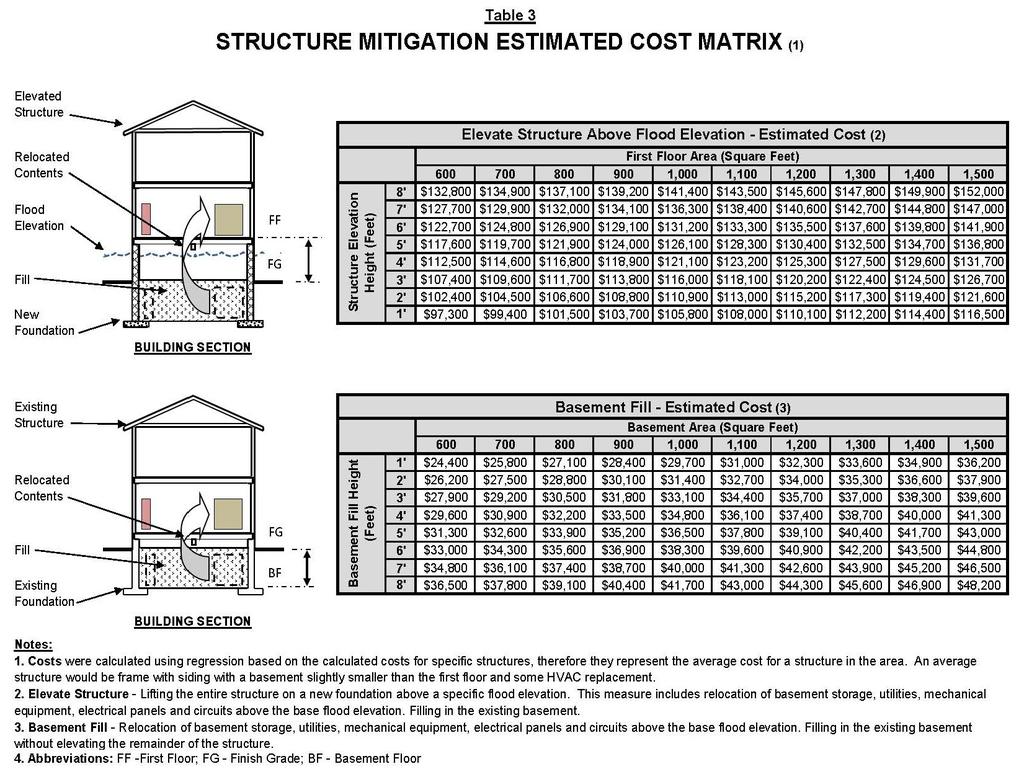
97 59
98 [Blank Page] 60
99 6.0 Abbreviations and Acronyms ACE...Annual Chance Exceedance A/E...Architect/Engineer AIA...American Institute of Architects ASFPM...Association of State Floodplain Managers AIA...American Institute of Architects BFE...Base Flood Elevation B...Basement CFM...Certified Floodplain Manager DFE...Design Flood Elevation EO...Executive Order FEMA...Federal Emergency Management Agency FF...First Floor FG...Finish Grade FIRM...Flood Insurance Rate Map FPM...Floodplain Management FPMP...Floodplain Management Plan FRAM...Flood Risk Adaptive Measure FRM... Flood Risk Management HQUSACE...Headquarters, U.S. Army Corps of Engineers HVAC...Heating Ventilation and Air Conditioning ID #...Identification Number LG...Low Grade (or Low Adjacent Grade) 61
100 LO...Low Opening MII...Second generation of the Micro-Computer Aided Cost Estimating System (MCASES) MCACES...Micro-Computer Aided Cost Estimating System NFIP...National Flood Insurance Program NFPC...National Nonstructural Flood Proofing Committee USACE...United States Army Corps of Engineers...Delta/Difference 62
 chance of being exceeded in any given")
 located adjacent to a structure that prevents the")

101 7.0 Glossary 100-year flood The 1% annual chance exceedance expressed as a return period. Annual chance exceedance flood The flood that has a (stated percent - %) chance of being exceeded in any given year, such as the 1% annual chance exceedance (ACE) flood. Berms, Levees, Floodwalls - Freestanding structure(s) located adjacent to a structure that prevents the encroachment of floodwaters. Examples shown in Figure 9 Figure 9 Berm/Floodwall Examples Breakaway Panel A panel designed and constructed to collapse under water loads without causing collapse, displacement, or other structural damage to a structure s bearing walls or supporting foundation system. 63


 - The effect, result, or outcome of inundation/flooding as reflected in the potential loss of life, economic losses, and adverse")
102 Closures / Shields Closures, shown in Figure 10, act to close the openings in flood barriers and prevent water from entering. They can be of a variety of shapes, sizes, and materials. In some cases closures are permanently attached using hinges so that they can remain open when there is not flood threat. They may also be portable, normally stored in a convenient location and slipped into place when a flood threatens. Figure 10 Closures / Shields (Detail) Community Any state or area or political subdivision thereof, or any Indian tribe or authorized tribal organization, or Alaska Native village, or authorized native organization that has the authority to adopt and enforce flood plain management regulations for the areas within its jurisdiction. Consequences (of inundation) - The effect, result, or outcome of inundation/flooding as reflected in the potential loss of life, economic losses, and adverse social - environmental impacts. Dry Flood Proofing involves temporary or permanent sealing building walls with waterproofing compounds, impermeable sheeting, or other materials to prevent the entry of floodwaters into damageable structures. Dry flood proofing, as shown in Figures 11 and 12, are applicable in areas of shallow, low velocity flooding Figure 11 Dry Flood Proofing (Details) 64


103 Figure 12 Temporary Dry Flood Proofing (Detail/Example) Elevation involves raising the buildings in place so that the structure sees a reduction in frequency and/or depth of flooding during high-water events. Elevation, as shown in Figure 13, can be done on fill, foundation walls, piers, piles, posts or columns. Selection of proper elevation method depends on flood characteristics such as flood depth or velocity. Figure 13 Elevation (Graphic Illustration) Federal Emergency Management Agency (FEMA) The agency within the Emergency Preparedness and Response Directorate of the U.S. Department of Homeland Security. FEMA facilitates coordination of Federal dam safety programs and administers the NFIP and several flood mitigation planning and grant programs. Fenestration The arrangement of windows and doors in a structure. FIRM Flood Insurance Rate Map Flood - A flood is an overflow of water that submerges land or structures which is normally dry. 65
Upper Joachim Creek Public Survey on Potential Flood Risk Reduction
 Upper Joachim Creek Public Survey on Potential Flood Risk Reduction This survey is intended to help the interagency planning committee to receive public feedback on specific flood risk reduction techniques,
IN THE LITTLE APPLE A PRESENTATION FOR THE 2017 ASFPM ANNUAL CONFERENCE IN KANSAS CITY, MO, MANAGING FLOOD RISK IN THE HEARTLAND
 A PRESENTATION FOR THE 2017 ASFPM ANNUAL CONFERENCE IN KANSAS CITY, MO, MANAGING FLOOD RISK IN THE HEARTLAND NONSTRUCTURAL 237 217 200 ASSESSMENT 80 252 237 217 200 119 174 237 217 200 27.59 IN THE LITTLE
ADVISORY BASE FLOOD ELEVATIONS (ABFEs)
") The Department of Homeland Security s Federal Emergency Management Agency is committed to helping communities that were impacted by Hurricanes Katrina and Rita rebuild safer and stronger. Following catastrophic
The Department of Homeland Security s Federal Emergency Management Agency is committed to helping communities that were impacted by Hurricanes Katrina and Rita rebuild safer and stronger. Following catastrophic
CRISP COUNTY, GEORGIA AND INCORPORATED AREAS
 CRISP COUNTY, GEORGIA AND INCORPORATED AREAS Community Name Community Number ARABI, CITY OF 130514 CORDELE, CITY OF 130214 CRISP COUNTY (UNINCORPORATED AREAS) 130504 Crisp County EFFECTIVE: SEPTEMBER 25,
Door County Floodplain Program Informational Meeting
 Door County Floodplain Program Informational Meeting Door County Land Use Services Department Wisconsin Department of Natural Resources January 15, 2018 Floodplain = Land affected by flood event with a
JAXGIS FEMA Flood Hazard Mapping -- Frequently Asked Questions
 Flood Hazard Zone Designations Summary Zones starting with the letter 'A' (for instance, Zone A, Zone AE, Zone AH, Zone AO) denote a Special Flood Hazard Area, which can also be thought of as the 100-year
ASFPM Partnerships for Statewide Mitigation Actions. Alicia Williams GIS and HMP Section Manager, Amec Foster Wheeler June 2016
 ASFPM Partnerships for Statewide Mitigation Actions Alicia Williams GIS and HMP Section Manager, Amec Foster Wheeler June 2016 Summary The Concept Leveraging Existing Data and Partnerships to reduce risk
City of Pensacola and Escambia County Flood Risk and Flood Insurance Study
 City of Pensacola and Escambia County Flood Risk and Flood Insurance Study Preliminary Report 1: Long Hollow and Sanders Beach Tracts Wharton Risk Management and Decision Processes Center November 8, 2016
Floodplain Management 101. Mississippi Emergency Management Agency Floodplain Management Bureau
 Floodplain Management 101 Mississippi Emergency Management Agency Floodplain Management Bureau Stafford Act The Stafford Disaster Relief and Emergency Assistance Act (Stafford Act) (Public Law 100-707)
BUTTS COUNTY, GEORGIA AND INCORPORATED AREAS
 BUTTS COUNTY, GEORGIA AND INCORPORATED AREAS Butts County Community Name Community Number BUTTS COUNTY (UNICORPORATED AREAS) 130518 FLOVILLA, CITY OF 130283 JACKSON, CITY OF 130222 JENKINSBURG, TOWN OF
Kevin Wagner Maryland Department of the Environment
 Kevin Wagner Maryland Department of the Environment Topics Overview of the National Flood Insurance Program (NFIP) Mapping Regulations Insurance Mitigation Community Rating System (CRS) Questions Know
Comprehensive Flood Mitigation for 12,000 Properties
 Comprehensive Flood Mitigation for 12,000 Properties Lori Rafferty, PE, CFM, Louisville MSD & Louie Greenwell, GISP, CFM, T&M Associates Association of State Floodplain Managers 2014 State Conference June
NFIP: October 2016 Updates and Community Decision Impacts on Individual Rates
 NFIP: October 2016 Updates and Community Decision Impacts on Individual Rates Carl Watts, Regional Liaison NFIP-iService, Region VI cwatts@nfip-iservice.com P: 405-257-9000 1 1 NFIP: Review and October
AMENDMENTS TO CHAPTER 50: FLOODPLAIN DEVELOPMENT
 AMENDMENTS TO CHAPTER 50: FLOODPLAIN DEVELOPMENT PART I: 2018 FLOOD MAP IMPLEMENTATION PART II: STRATEGIES TO IMPROVE THE CITY S COMMUNITY RATING SYSTEM SCORE NATIONAL FLOOD INSURANCE PROGRAM (NFIP) CREATED
Floodplain Management Services Baltimore District Studies
 Floodplain Management Services Baltimore District Studies FACT SHEET as of December 31, 2014 AUTHORIZATION: Floodplain Management Services (FPMS) TYPE OF PROJECT: Flood Risk Management (Technical Services)
Situation: the need for non-structural flood risk reduction measures
 Evaluating benefits of non-structural measures in flood risk management feasibility studies At left: Example of a house on an open foundation Source Asheville, NC (undated) By Steve Cowdin, CFM; Natalie
Westfield Boulevard Alternative
 Westfield Boulevard Alternative Supplemental Concept-Level Economic Analysis 1 - Introduction and Alternative Description This document presents results of a concept-level 1 incremental analysis of the
National Flood Insurance Program
 National Flood Insurance Program FEMA ELEVATION CERTIFICATES PA Surveyor Training Presented by Thomas F. Smith, PE, PLS January 22, 2018 1 FEMA Region III Mitigation Division Floodplain Management & Insurance
FREQUENTLY ASKED QUESTION ABOUT FLOODPLAINS Michigan Department of Environmental Quality
 FREQUENTLY ASKED QUESTION ABOUT FLOODPLAINS Michigan Department of Environmental Quality WHAT IS A FLOOD? The National Flood Insurance Program defines a flood as a general and temporary condition of partial
MOKAN CRS Users Group Activity 310, Elevation Certificates Packet
 http://mokan.stormsmart.org/ MOKAN CRS Users Group Activity 310, Elevation Certificates Packet This packet includes the following documents to be used as applicable to your community: EC checklist EC correction
In 1993, spring came in like a lion, but refused
 36 UNIVERSITIES COUNCIL ON WATER RESOURCES ISSUE 130, PAGES 36-40, MARCH 2005 FEMA and Mitigation: Ten Years After the 1993 Midwest Flood Norbert Director of Federal Insurance and Mitigation Division Federal
FEMA Elevation Certificates and Hydrostatic Venting Requirements
 FEMA Elevation Certificates and Hydrostatic Venting Requirements Tennessee Association of Floodplain Managers Conference Gatlinburg, TN July 30 August 2, 2013 1 What is the National Flood Insurance Program
National Flood Insurance Program
 National Flood Insurance Program A Discussion in Three Parts: The Nature of Flood Risk An Overview of the NFIP Impact of Recent Legislation (BW-12 & HFIAA-14) Nature of Flood Risk FLOODS ARE AN ACT OF
National Flood Insurance Program, Biggert-Waters 2012, and Homeowners Flood Insurance Affordability Act 2014
 National Flood Insurance Program, Biggert-Waters 2012, and Homeowners Flood Insurance Affordability Act 2014 Janice Mitchell, Insurance Specialist Floodplain Management and Insurance Branch FEMA Region
National Institute of Building Sciences
 National Institute of Building Sciences Provider Number: G168 Improving the Flood Resistance of Buildings and Mitigation Techniques WE3B Peter Spanos, P.E., CFM, LEED AP (Gale Associates, Inc.) Stuart
Floodplain Design, Construction, and Impacts On Flood Insurance
 Floodplain Design, Construction, and Impacts On Flood Insurance AIA/CES Registration Architectural Record is a registered provider with The American Institute of Architects Continuing Education Systems.
Abington Township Public Meeting
 Abington Township Public Meeting Flood Insurance Rate Map Update March 23, 2016 1 Meeting Agenda and Format Provide residents/property owners of Abington Township with information about the map update,
SPECIAL CERTIFICATIONS
 SPECIAL CERTIFICATIONS This section presents detailed instructions for the completion of the National Flood Insurance Program (NFIP) Elevation Certificate (EC) and the NFIP Floodproofing Certificates.
Skagit County Flood Insurance Study Update. Ryan Ike, CFM FEMA Region 10
 Skagit County Flood Insurance Study Update Ryan Ike, CFM FEMA Region 10 Skagit County Flood Insurance Study Process Overview Process, Schedule, & Deliverables Base Flood Elevations, Modeling, & Levees
Flood Risk Assessment in the
 Georgia Flood M.A.P. Program Flood Risk Assessment in the Upper Chattahoochee h h River Basin GAFM Annual Conference March 28, 2012 Agenda Map Mod to Risk MAP (Georgia Flood M.A.P.) transition Flood Risk
Pre-Development Floodplain Application
 Pre-Development Floodplain Application The Department of Planning, at the recommendation of FEMA, is now requiring completion of a Pre- Development Floodplain Application for all properties in the regulated
Comparing HAZUS Flood Loss Estimates Across Hazard Identification Methods and Building Stock Inventory Data. Albion Township Dane County, Wisconsin
 Across Hazard Identification Methods and Building Stock Inventory Data Albion Township Dane County, Wisconsin Prepared for the Association of State Floodplain Managers September 1, 2010 Across Various
October 1, Write Your Own (WYO) Principal Coordinators and the National Flood Insurance Program (NFIP) Servicing Agent
 Principal Coordinators and the National Flood Insurance Program (NFIP) Servicing Agent") U.S. Department of Homeland Security Washington, D.C. 20472 October 1, 2015 MEMORANDUM FOR: Write Your Own (WYO) Principal Coordinators and the National Flood Insurance Program (NFIP) Servicing Agent FROM:
U.S. Department of Homeland Security Washington, D.C. 20472 October 1, 2015 MEMORANDUM FOR: Write Your Own (WYO) Principal Coordinators and the National Flood Insurance Program (NFIP) Servicing Agent FROM:
PARK COUNTY, WYOMING AND INCORPORATED AREAS
 PARK COUNTY, WYOMING AND INCORPORATED AREAS Community Name Community Number CODY, CITY OF 560038 MEETEETSE, TOWN OF 560039 PARK COUNTY UNINCORPORATED AREAS 560085 POWELL, CITY OF 560040 June 18, 2010 Federal
ENGINEERING AND CONSTRUCTION BULLETIN
 ENGINEERING AND CONSTRUCTION BULLETIN No. 2016-8 Issuing Office: CECW-CE Issued: 22 Feb 16 Expires: 22 Feb 18 SUBJECT: Interim Risk Reduction Measures (IRRMs) for Levee Safety CATEGORY: Directive and Policy
April 3, 4, & 5, 2017 Pittsburgh, Butler, Erie Western PA
 April 3, 4, & 5, 2017 Pittsburgh, Butler, Erie Western PA 2 Hazard Mitigation is: any cost-effective action taken to eliminate or reduce the long term risk to life and property from natural and technological
Federal Emergency Management Agency
 Page 1 of 3 COMMUNITY AND MAP PANEL INFORMATION COMMUNITY CITY OF MARGATE CITY, ATLANTIC COUNTY, NEW JERSEY LEGAL PROPERTY DESCRIPTION A parcel of land, as described in Deed recorded in Book 4826, page
SECTION 9: MAPS AND DATA
 SECTION 9: MAPS AND DATA Contents 9.1. NFIP Maps and Data... 9-2 9.1.1. Adopting and enforcing NFIP floodplain maps and data... 9-2 9.1.2. Adopting and enforcing more restrictive data... 9-2 9.1.3. Annexations...
Historic Structures in the Floodplain
 Historic Structures in the Floodplain Frances McJunkin, CFM Deputy Director Sal Vitko Hazard Reduction Planner County of Lycoming Department of Planning & Community Development Pennsylvania Statewide Conference
Pricing storm surge risks in Florida: Implications for determining flood insurance premiums and evaluating mitigation measures
 Pricing storm surge risks in Florida: Implications for determining flood insurance premiums and evaluating mitigation measures Marilyn Montgomery Postdoctoral Fellow, Wharton Risk Center, University of
Action Items for Flood Risk Management on Wildcat Creek Interagency success with floodplain management plans and flood forecast inundation maps
 Presentation to USACE 2012 Flood Risk Management and Silver Jackets Joint Workshop, Harrisburg, Pennsylvania Action Items for Flood Risk Management on Wildcat Creek Interagency success with floodplain
Pricing storm surge risks in Florida: Implications for determining flood insurance premiums and evaluating mitigation measures
 Pricing storm surge risks in Florida: Implications for determining flood insurance premiums and evaluating mitigation measures Marilyn Montgomery Postdoctoral Fellow, Wharton Risk Center, University of
City of Ocean City Permit and Application Process Quality Improvement
 Introduction. This report embodies a thorough evaluation of Ocean City s land use approval and development permitting procedures. Specific reference is made to application requirements and administrative
Best Practices. for Incorporating Building Science Guidance into Community Risk MAP Implementation November 2012
 Best Practices for Incorporating Building Science Guidance into Community Risk MAP Implementation November 2012 Federal Emergency Management Agency Department of Homeland Security 500 C Street, SW Washington,
Herkimer County, New York Flood Hazard Mapping Status Report for Property Owners
 Herkimer County, New York Flood Hazard Mapping Status Report for Property Owners Herkimer County, New York Flood Hazard Mapping Status Report for Property Owners FLOOD INSURANCE Who Should Purchase Flood
National Flood Insurance Program Making Sense of April 2019 Changes
 National Flood Insurance Program Making Sense of April 2019 Changes Foreword The National Flood Insurance Program (NFIP) provides an important means for property owners to protect themselves financially
Many of the changes to the NFIP were recently revised on March 21, 2014 by the Homeowner Flood Insurance Affordability Act of 2014.
 F l oodawa r e ne swe e k Ma r c h19-ma r c h25 2017 Below is a summary of the topics we will discuss today. On July 6, 2012, the Biggert-Waters Flood Insurance Reform Act of 2012 was passed by Congress
Pinellas County Flood Map Information Service & Real Estate Disclosure Program Training January 26, 2017 COMMON FLOODPLAIN ACRONYMS
 FEMA ASFPM BFE CAV Pinellas County Flood Map Information Service & Real Estate Disclosure Program Training COMMON FLOODPLAIN ACRONYMS Federal Emergency Management Agency Association of State Floodplain
WASHINGTON COUNTY, KENTUCKY AND INCORPORATED AREAS
 WASHINGTON COUNTY, KENTUCKY AND INCORPORATED AREAS COMMUNITY NAME COMMUNITY NUMBER *MACKVILLE, CITY OF 210475 SPRINGFIELD, CITY OF 210220 WASHINGTON COUNTY (UNINCORPORATED AREAS) 210365 *WILLISBURG, CITY
University Drive Flood Risk Management Project Phase I 58 th Ave S to 500 S of 64 th Ave S City of Fargo Project FM-15-C1
 University Drive Flood Risk Management Project Phase I 58 th Ave S to 500 S of 64 th Ave S City of Fargo Project FM-15-C1 Public Informational Meeting October 15, 2015 6:00 P.M. Overview Flood Risk FEMA
Using GISWeb to Determine Your Property s Flood Zone
 Using GISWeb to Determine Your Property s Flood Zone 1. In a new browser window, go to http://www.co.santacruz.ca.us/departments/geographicinformationsystemsgis.aspx 2. Click on GISWeb - GIS Mapping Application
Reconstruction Implications
 Federal Emergency Management Agency (FEMA) Recovery Guidance Advisory Base Flood Elevation (ABFE) of April 12, 2006 Reconstruction Implications Presentation to: City of New Orleans July 6 th, 2006 Lambert
Walter Road Jefferson Parish Repetitive Loss Area Analysis
 Walter Road Jefferson Parish Repetitive Loss Area Analysis www.floodhelp.uno.edu Supported by FEM A Repetitive Loss Area Analysis Background Jefferson Parish Walter Road Area The National Flood Insurance
W October 1, Write Your Own (WYO) Principal Coordinators and the National Flood Insurance Program (NFIP) Servicing Agent
 Principal Coordinators and the National Flood Insurance Program (NFIP) Servicing Agent") U.S. Department of Homeland Security 500 C St. SW Washington, D.C. 20472 W-14053 October 1, 2014 MEMORANDUM FOR: Write Your Own (WYO) Principal Coordinators and the National Flood Insurance Program (NFIP)
U.S. Department of Homeland Security 500 C St. SW Washington, D.C. 20472 W-14053 October 1, 2014 MEMORANDUM FOR: Write Your Own (WYO) Principal Coordinators and the National Flood Insurance Program (NFIP)
Why do we care about floodplains?
 NFIP 101 Outline What is the NFIP? What are its goals? What is a flood? A floodplain? Maps, FIRMs, and FISs NFIP Requirements Local Flood Ordinances & Permitting Tips, Tricks, & Tools Mitigation & Other
Floodplain Management Assessment
 CHEHALIS RIVER BASIN Floodplain Management Assessment Master Report Final April, 2015 TABLE OF CONTENTS Executive Summary... 1 Introduction... 2 The Floodplain... 4 Floodplain Development... 4 Floodplain
Requirements for Mapping Levees Complying with Section of the NFIP Regulations
 FACT SHEET Requirements for Mapping Levees Complying with Section 65.10 of the NFIP Regulations As part of a mapping project, it is the levee owner s or community s responsibility to provide data and documentation
Flood Risk Management and Nonstructural Flood Risk Adaptive Measures
 Flood Risk Management and Nonstructural Flood Risk Adaptive Measures Randall Behm, P.E., CFM USACE-Omaha District Chair, National Nonstructural Flood Proofing Committee US Army Corps of Engineers BUILDING
Oak Island 1999 Hurricane Floyd
 Oak Island 1999 Hurricane Floyd Topics to be Discussed What is a flood zone Flood zones in Oak Island Special Flood Hazard Areas (SFHA) Flood insurance Base Flood Elevations (BFEs) Building in flood zones
GPS elevation surveys a key to proactive flood plain management
 Destructive Water: Water-Caused Natural Disasters, their Abatement and Control (Proceedings of the Conference held at Anaheim, California, June 1996). IAHS Publ. no. 239, 1997. 331 GPS elevation surveys
Changes Coming to the National Flood Insurance Program What to Expect. Impact of changes to the NFIP under Section 205 of the Biggert-Waters Act
 Changes Coming to the National Flood Insurance Program What to Expect Impact of changes to the NFIP under Section 205 of the Biggert-Waters Act Flood Risk Flood risks and the costs of flooding Weather
April 2, Write Your Own Principal Coordinators and the NFIP Servicing Agent
 U.S. Department of Homeland Security 500 C Street, SW Washington, DC 20472 W-09021 April 2, 2009 MEMORANDUM TO: Write Your Own Principal Coordinators and the NFIP Servicing Agent FROM: SUBJECT: Edward
Durham County Preliminary Flood Hazard Data Public Meeting. July 28, 2016
 Durham County Preliminary Flood Hazard Data Public Meeting July 28, 2016 Why Are We Here New flood hazard data has been released as Preliminary for Durham County Statutory Due Process for review/comments
NFIP Program Basics. KAMM Regional Training
 NFIP Program Basics KAMM Regional Training Floodplain 101 Homeowners insurance does not cover flood damage Approximately 25,000 flood insurance policies in KY According to BW12 analysis, approximately
Meeting the Nation s Levee Challenges
 ASDSO USACE/FEMA Levee Discussion Meeting the Nation s Levee Challenges November 2015 Presenters: Richard Varuso, USACE Michael Bishop, FEMA 1 This Session s Objective KNOWLEDGE - Provide you with insight
California Building Code and the NFIP. John Ingargiola, Senior Engineer FEMA Building Science Branch
 California Building Code and the NFIP John Ingargiola, Senior Engineer FEMA Building Science Branch CA Major Disaster Declarations and Federal Assistance $21 $21 $76 $78 7 declarations, 2004-2016, total
Delaware River Basin Commission s Role in Flood Loss Reduction Efforts
 Delaware River Basin Commission s Role in Flood Loss Reduction Efforts There is a strong need to reduce flood vulnerability and damages in the Delaware River Basin. This paper presents the ongoing role
Flood Risk Review (FRR) Meeting. Cumberland County, Pennsylvania Carlisle, Pennsylvania December 5, 2016
 Meeting. Cumberland County, Pennsylvania Carlisle, Pennsylvania December 5, 2016") Flood Risk Review (FRR) Meeting Cumberland County, Pennsylvania Carlisle, Pennsylvania December 5, 2016 Why are we here today? The Flood Insurance Study (FIS) report and Flood Insurance Rate Maps (FIRMs)
Flood Risk Review (FRR) Meeting Cumberland County, Pennsylvania Carlisle, Pennsylvania December 5, 2016 Why are we here today? The Flood Insurance Study (FIS) report and Flood Insurance Rate Maps (FIRMs)
FEMA FLOOD MAPS Public Works Department Stormwater Management Division March 6, 2018
 FEMA FLOOD MAPS Public Works Department Stormwater Management Division March 6, 2018 Presentation Overview FEMA National Flood Insurance Program (NFIP) FEMA Community Rating System (CRS) Flood Insurance
Chapter 6 - Floodplains
 Chapter 6 - Floodplains 6.1 Overview The goal of floodplain management is to reduce the potential risks to both existing and future developments, and infrastructure, in the 100-year floodplain. Over the
Sources of FEMA Funding
 ASFPM Nonstructural/Floodproofing Workshops Sources of FEMA Funding ASFPM Nonstructural/Floodproofing Committee Gene Barr, CFM Principal Project Manager Nonstructural Specialist Sources of FEMA Funding
DES MOINES CITY OF TWO RIVERS. Flooding Risk & Impact to Development
 DES MOINES CITY OF TWO RIVERS Flooding Risk & Impact to Development River System Des Moines Flood Protection Des Moines Flood Protection cont. Infrastructure Over 24 miles of levees 21stormwater pump stations
National Capitol Region HAZUS User Group Call
 Listen to the recording here to follow along with the presentation: http://www.freeconferencecalling.com/recordings/recording.aspx?fileid=l AF3494_04252013070630062_1154707&bridge=697620&email=&account
Introduction to the National Flood Insurance Program: A Guide for Coastal Property Owners MAINE BEACHES CONFERENCE 2017
 Introduction to the National Flood Insurance Program: A Guide for Coastal Property Owners MAINE BEACHES CONFERENCE 2017 SUE BAKER, CFM STATE NFIP COORDINATOR MAINE DEPT OF AGRICULTURE, CONSERVATION & FORESTRY
Integrating Hazus into the Flood Risk Assessment
 Integrating Hazus into the Flood Risk Assessment GAFM Conference, March 22, 2016 Mapping Assessment Planning Agenda What is Hazus & Risk Assessment? Census Block vs. Site Specific Analysis User Defined
CDBG-DR, BW-12, CRS and Dauphin County, PA: What do they have in common? 2015 ASFPM Annual Conference
 CDBG-DR, BW-12, CRS and Dauphin County, PA: What do they have in common? 2015 ASFPM Annual Conference June 3, 2015 Today's Speaker Rob Flaner Hazard Mitigation Program Manager, Tetra Tech, Inc. Over 25
National Flood Insurance Program (NFIP) for Real Estate Professionals
 for Real Estate Professionals") National Flood Insurance Program (NFIP) for Real Estate Professionals 1 Joshua Oyer, CFM Outreach Specialist NFIP State Coordinator s Office at the Texas Water Development Board 2 Outline Introduction
National Flood Insurance Program (NFIP) for Real Estate Professionals 1 Joshua Oyer, CFM Outreach Specialist NFIP State Coordinator s Office at the Texas Water Development Board 2 Outline Introduction
10526 Bermuda Isle Dr. Tampa, FL 33647
 Flood Analysis Memo Property Address In Partnership with: ** This property is NOT within a high-risk flood zone ** This property is located in a FEMA low-risk zone designated as Zone X - an area of minimal
May 1, Write Your Own (WYO) Principal Coordinators and the National Flood Insurance Program (NFIP) Servicing Agent
 Principal Coordinators and the National Flood Insurance Program (NFIP) Servicing Agent") U.S. Department of Homeland Security 500 C St. SW Washington, D.C. 20472 W-15016 May 1, 2015 MEMORANDUM FOR: Write Your Own (WYO) Principal Coordinators and the National Flood Insurance Program (NFIP)
U.S. Department of Homeland Security 500 C St. SW Washington, D.C. 20472 W-15016 May 1, 2015 MEMORANDUM FOR: Write Your Own (WYO) Principal Coordinators and the National Flood Insurance Program (NFIP)
Flood Insurance for Local Officials and Floodplain Managers. What Every Community Official Needs to Know About Flood Insurance
 Flood Insurance for Local Officials and Floodplain Managers What Every Community Official Needs to Know About Flood Insurance Illinois Association for Floodplain and Stormwater Management 2011 Annual Conference
ATTACHMENT A SUMMARY OF THE NFIP OCTOBER 2013 PREMIUM RATE AND RULE CHANGES
 ATTACHMENT A SUMMARY OF THE NFIP OCTOBER 2013 PREMIUM RATE AND RULE CHANGES National Flood Insurance Program October 1, 2013, Premium Rate and Rule Changes: A Summary 1. Premium Increases Premiums will
On March 21, 2014, President Obama signed the Homeowner Flood Insurance Affordability Act of 2014 into law.
 On March 21, 2014, President Obama signed the Homeowner Flood Insurance Affordability Act of 2014 into law. This law repeals and modifies certain provisions of the Biggert-Waters Flood Insurance Reform
Michael Taylor, PE, CFM Project Manager, AECOM August 25, 2015
 Promoting FEMA s Flood Risk Products in the Lower Levisa Watershed Michael Taylor, PE, CFM Project Manager, AECOM August 25, 2015 Agenda Study Background Flood Risk Product Overview AOMI and Mitigation
National Flood Insurance Program and Biggert-Waters 2012
 National Flood Insurance Program and Biggert-Waters 2012 National Flood Insurance Program NFIP was created by Congress in 1968 Coverage underwritten by the Federal Government, administered by FEMA NFIP
Erie County Flood Risk Review Meeting. January 18, 2018
 Erie County Flood Risk Review Meeting January 18, 2018 Agenda The value of updated flood maps for your community Review updated flood-risk data and important next steps in the Risk MAP process Increasing
Agenda. Introduction. Introduction -Map Study Lifecycle. Insurance Benefits of New Map
 Agenda Introduction Effects of Map Changes on Flood Insurance Lower risk to higher risk ( Grandfathering ) Higher risk to lower risk ( Conversion ) No Change Vertical Datum change Summary Levees Levees
April 16, Write Your Own (WYO) Principal Coordinators and the National Flood Insurance Program (NFIP) Servicing Agent
 Principal Coordinators and the National Flood Insurance Program (NFIP) Servicing Agent") U.S. Department of Homeland Security 500 C Street, SW Washington, DC 20472 W-12028 April 16, 2012 MEMORANDUM TO: Write Your Own (WYO) Principal Coordinators and the National Flood Insurance Program (NFIP)
U.S. Department of Homeland Security 500 C Street, SW Washington, DC 20472 W-12028 April 16, 2012 MEMORANDUM TO: Write Your Own (WYO) Principal Coordinators and the National Flood Insurance Program (NFIP)
COMMUNITY CERTIFICATIONS
 OMB No. xxxxxxxx Expires: xxxxxxxx National Flood Insurance Program Community Rating System COMMUNITY CERTIFICATIONS D R A F T CRS COMMUNITY CERTIFICATIONS The following community certifications are part
Georgia Silver Jackets Team
 Georgia Silver Jackets Team 9 th Annual GAFM Technical Conference Jeff Morris GA SJ Collaborator Savannah District, USACE US Army Corps of Engineers SMART GOVERNMENT Integrate and synchronize flood risk
Federal Emergency Management Agency
 Page 1 of 5 Issue Date: July 27, 2012 Effective Date: December 10, 2012 Case No.: 11-06-4512P Follows Conditional Case No.: 06-06-B789R LOMR-APP Federal Emergency Management Agency Washington, D.C. 20472
210 W Canal Dr Palm Harbor, FL 34684
 Flood Analysis Memo Property Address In Partnership with: ** This property is within a high risk flood zone ** BFE = 6 ft This property is located in the FEMA designated high-risk zone, Zone AE - an area
Biggert-Waters The Changing Script
 Biggert-Waters 2012 The Changing Script Policyholder Subsidies These policies are not Pre-FIRM subsidized (already actuarially rated), 4,480,669 policies. They are not affected by 205 but may see routine
LELAND CONSULTING GROUP
 Memorandum Date 25 April 2013 To From CC Thomas Puttman, Puttman Infrastructure April Chastain, Leland Consulting Group Chris Zahas, Leland Consulting Group Matt Arnold, SERA Architects Kevin Cronin, Portland
Hazard Mitigation Grants. Technical Assistance Session Middlesex County, NJ December 7, 2011
 Hazard Mitigation Grants Technical Assistance Session Middlesex County, NJ December 7, 2011 Outline Purpose of Hazard Mitigation Hazard Mitigation Projects Hazard Mitigation Assistance Grant Programs Using
CDBG-DR, BW-12, CRS and Dauphin County, PA: What do they have in common? 2015 FMA Annual Conference
 CDBG-DR, BW-12, CRS and Dauphin County, PA: What do they have in common? 2015 FMA Annual Conference September 9, 2015 Today's Speaker Kristen Gelino Hazard Mitigation Planner, Tetra Tech, Inc. 2 years
CONDOMINIUMS I. METHODS OF INSURING CONDOMINIUMS. Important Notice to Agents/Producers:
 Previous Section Main Menu Table of Contents Next Section Important Notice to Agents/Producers: CONDOMINIUMS Boards of directors of condominium associations typically are responsible under their by-laws
10526 Bermuda Isle Dr. Tampa, FL 33647
 Flood Analysis Memo Property Address 10526 Bermuda Isle Dr. In Partnership with: ** This property is NOT within a high-risk flood zone ** 10526 Bermuda Isle Dr. BFE = 35 ft This property is located in
NFIP Overview Elevation Certificate Flood Insurance Rate Maps. By: Maureen O Shea, AICP, CFM State NFIP Coordinator
 NFIP Overview Elevation Certificate Flood Insurance Rate Maps By: Maureen O Shea, AICP, CFM State NFIP Coordinator Example of a flood failure Example of a flood failure Purposes of the NFIP Identify &
SILVER JACKETS: TEAMING TO MITIGATE AND MANAGE STATE FLOOD HAZARD PRIORITIES
 SILVER JACKETS: TEAMING TO MITIGATE AND MANAGE STATE FLOOD 255 255 255 237 237 237 0 0 0 217 217 217 163 163 163 200 200 200 131 132 122 239 65 53 80 119 27 HAZARD PRIORITIES 110 135 120 252 174.59 112
Floodplain Development Permit Application
 Floodplain Development Permit Application **All construction will also require a building permit** This is an application packet for a Floodplain Development Permit. Certain sections are to be completed