Comprehensive Flood Mitigation for 12,000 Properties
|
|
|
- Ashlynn Warner
- 5 years ago
- Views:
Transcription


1 Comprehensive Flood Mitigation for 12,000 Properties Lori Rafferty, PE, CFM, Louisville MSD & Louie Greenwell, GISP, CFM, T&M Associates Association of State Floodplain Managers 2014 State Conference June 4, 2015
2 PRESENTATION OUTLINE Project background Methodology Document previous mitigation Develop floodprone inventory Risk evaluation Develop mitigation alternatives Community Rating System benefits Next steps


3 PROJECT BACKGROUND Louisville, KY is a river town Significant history of flooding


4 PROJECT BACKGROUND Approximately 15% of Louisville/Jefferson County is in the floodplain 12,000 floodprone properties 44 SRL Properties 278 RL Properties
5


6 HISTORICAL FLOODING ,000 people evacuated Ohio River crested about 40 above normal pool

7 HISTORICAL FLOODING Floodwall and Levee System 28.9 miles long Protects approximately 80,000 properties 16 flood pump stations

8 HISTORICAL FLOODING 1997 Up to 12.5 inches in 2 days Ohio River crested 26 above normal pool


9 HISTORICAL FLOODING September 2006: Up to 10 in 24 hrs


10 HISTORICAL FLOODING August 2009: Up to 8 in 75 minutes


11 HISTORICAL FLOODING October 2013 Up to 7 in 24 hrs


12 HISTORICAL FLOODING March 2015 Ohio River flooding


13 HISTORICAL FLOODING April in 24 hours

14 PREVIOUS BUYOUTS
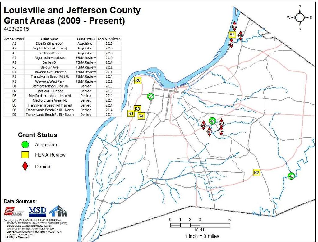
15

16 PROJECT JUSTIFICATION Widespread flooding issues Reactive mitigation projects Needed a Comprehensive Mitigation Plan Fair and balanced Easy to communicate Transparent Include floodprone Combined Sewer Area
17 PROJECT SCOPE Develop a plan to address countywide flooding issues for approximately 12,000 flood prone structures Project Task / Activities Task 1: Document Prior Mitigation Activities Task 2: Grant Administration & Support Task 3: Grant Development Task 4: Countywide Mitigation Inventory Task 5: Risk Evaluation Task 6: Define Mitigation Options/Actions Task 7: Compile List of Alternative Funding Sources Task 8: Develop Countywide Report & Presentation Task 9: Coordination with MSD CRS Team Task 10: October 2013 Mitigation Support
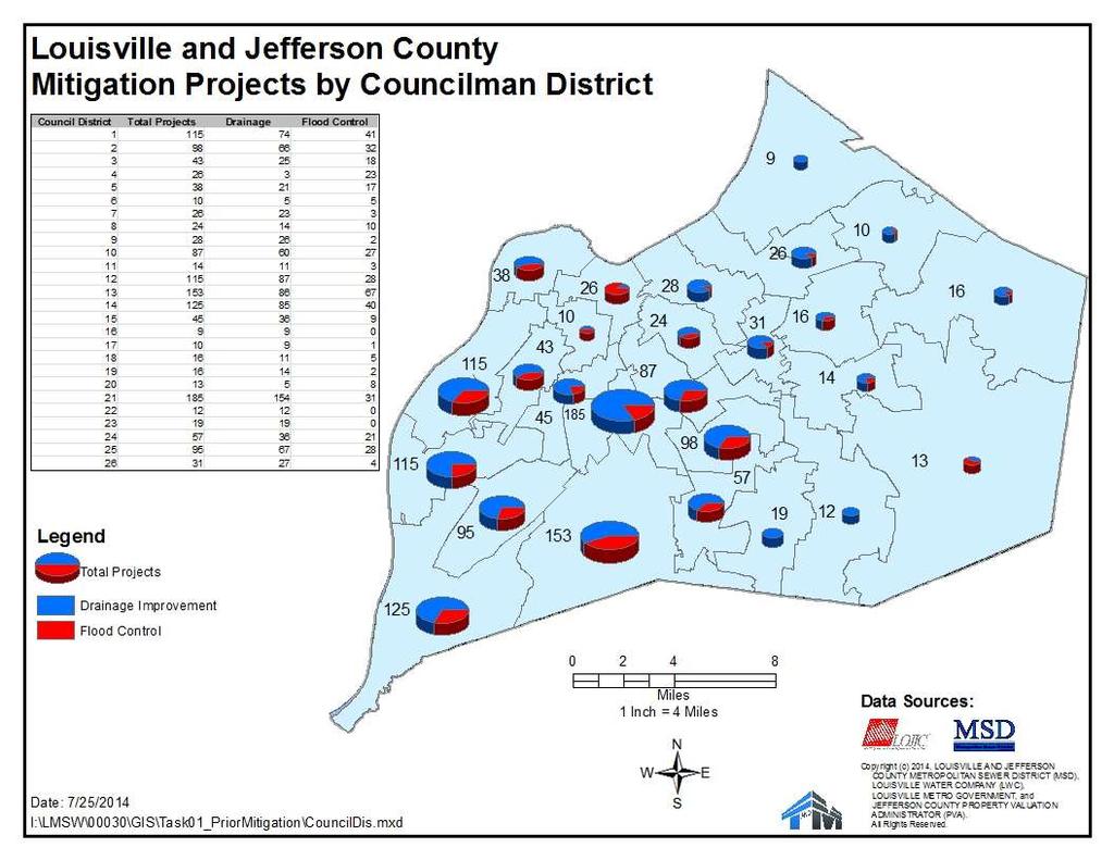
18 PRIOR MITIGATION PROJECTS Almost 700 completed projects identified Used multiple source documents Prior Grant submissions Board Presentations 50 year history of MSD and other historical documents Review of plans in eb Each classified by type of mitigation (e.g., acquisition, elevation, basin, floodwall/levee, floodproofing) Designated as flood control or local drainage improvement Identified the project year and cost/funding where available
19
20
21
22
23 COUNTYWIDE MITIGATION PRIORITIZATION Identify Flood Prone Structures Data collection from multiple sources Property value info from County PVA Ground elevation data from LOJIC GIS Determine foundation height from desktop analysis Define project areas based on hydraulically connected areas Export data to FEMA BCA software to calculate annualized damages Identify and Estimate costs for mitigation measures

24 AT-RISK STRUCTURE INVENTORY
25 COUNTYWIDE MITIGATION PRIORITIZATION Identify Flood Prone Structures Data collection from multiple sources Property value info from County PVA Ground elevation data from LOJIC GIS Determine foundation height from desktop analysis Define project areas based on hydraulically connected areas Export data to FEMA BCA software to calculate annualized damages Identify and Estimate costs for mitigation measures

26 AT-RISK STRUCTURE INVENTORY
27 COUNTYWIDE MITIGATION PRIORITIZATION Identify Flood Prone Structures Data collection from multiple sources Property value info from County PVA Ground elevation data from LOJIC GIS Determine foundation height from desktop analysis Define project areas based on hydraulically connected areas Export data to FEMA BCA software to calculate annualized damages Identify and Estimate costs for mitigation measures
 with a 5 cell size created from 2012 LiDAR The script completely automates HAG/LAG determination (a few minutes for 12,000")
28 DETERMINE HIGHEST & LOWEST ADJACENT GRADES Determine HAG & LAG using ArcGIS ModelBuilder script Uses LOJIC Digital Elevation Model (DEM) with a 5 cell size created from 2012 LiDAR The script completely automates HAG/LAG determination (a few minutes for 12,000 structures)
29 COUNTYWIDE MITIGATION PRIORITIZATION Identify Flood Prone Structures Data collection from multiple sources Property value info from PVA Ground elevation data from LOJIC Determine foundation height from desktop analysis Define project areas based on hydraulically connected areas Export data to FEMA BCA software to calculate annualized damages Identify and Estimate costs for mitigation measures

30 DETERMINE FOUNDATION HEIGHT
31 DETERMINE FOUNDATION HEIGHT Compared Results to prior completed survey of 263 First Floor Elevations (FFE) of Repetitive Loss Structures (2012) Average difference was 0.3 Maximum difference was 2.4 and that was due to misclassification of the first floor on a split level home Standard Deviation = 0.86, therefore 68% are within % are within 1.72 Future task compare to ~2,000 EC database
32 COUNTYWIDE MITIGATION PRIORITIZATION Identify Flood Prone Structures Data collection from multiple sources Property value info from PVA Ground elevation data from LOJIC Determine foundation height from desktop analysis Define project areas based on hydraulically connected areas Export data to FEMA BCA software to calculate annualized damages Identify and Estimate costs for mitigation measures

33
34 COUNTYWIDE MITIGATION PRIORITIZATION Identify Flood Prone Structures Data collection from multiple sources Property value info from County PVA Ground elevation data from LOJIC GIS Determine foundation height from desktop analysis Define project areas based on hydraulically connected areas Export data to FEMA BCA software to calculate annualized damages Identify and Estimate costs for mitigation measures


35 FEMA BENEFIT-COST ANALYSIS
36 COUNTYWIDE MITIGATION PRIORITIZATION Identify Flood Prone Structures Data collection from multiple sources Property value info from County PVA Ground elevation data from LOJIC GIS Determine foundation height from desktop analysis Define project areas based on hydraulically connected areas Export data to FEMA BCA software to calculate annualized damages Identify mitigation measures and estimate costs


37 COUNTYWIDE MITIGATION PRIORITIZATION Alternatives considered Acquisition Elevation on Foundation Walls Berms or Barrier walls Detention Basins Enlarging Culvert/Drainage Improvement Dry Floodproofing Wet Floodproofing
 58 Number of Claims 4 Value of Claims $8,725 Rep Loss Properties 0 SRL Properties")
38 EXAMPLE PROJECT AREA BROOKLAWN TRIB Watershed Project ID Project Name Flooding Source South Fork Beargrass Creek SFBC001 Brooklawn Tributary Brooklawn Tributary Floodprone Primary Structures (100 yr) 58 Number of Claims 4 Value of Claims $8,725 Rep Loss Properties 0 SRL Properties 0
39 ANALYSIS AND RECOMMENDATION Annualized Damages Existing Conditions Annualized Damages with Annualized Loss Proposed Avoided Mitigation Alternatives # of Structure Present Worth Loss Avoided Present Worth Project Cost BCR Acquisition - Apartments/Condos 6 $6,688 $ - $6,688 $95,433 $1, Acquisition - Non- Residential 10 $12,306 $ - $12,306 $175,527 $9,357, Acquisition - Residential <0' 40 $10,785 $ - $10,785 $150,912 $5,505, Acquisition - Residential 0-2.9' 1 $612 $ - $612 $8,729 $114, Acquisition - Residential 3-5' 1 $12,559 $ - $12,559 $179,214 $182, Elevation on Foundation Walls 18 $22,497 $ - $22,497 $321,015 $4,122, Floodwall/Berm Dry Flood Proofing Wet Flood Proofing 23 $1,734 $ - $1,734 $24,743 $107, Channelization / Diversion Detention Basin $3,461,030 Recommendation: Acquisition for 1 structure whose flooding depth is between 3' & 5'
 105 Number of Claims 114 Value of Claims $1,332,296 Rep Loss Properties 24 SRL")
40 EXAMPLE PROJECT AREA HAYFIELD DUNDEE Watershed South Fork Beargrass Creek Project ID SFBC002 Project Name Flooding Source Hayfield-Dundee South Fork Beargrass Creek Floodprone Primary Structures (100 yr) 105 Number of Claims 114 Value of Claims $1,332,296 Rep Loss Properties 24 SRL Properties 0
41 ANALYSIS AND RECOMMENDATION Mitigation Alternatives # of Structure Annualized Damages Existing Conditions Annualized Damages with Proposed Annualized Loss Avoided Present Worth Loss Avoided Present Worth Project Cost Acquisition - Apartments/ Condos 8 $1,034 $ - $1,034 $14,753 $4,453,527 0 Acquisition - Non- Residential 4 $6,143 $ - $6,143 $87,652 $2,952, Acquisition - Residential <0' 70 $99,629 $ - $99,629 $1,421,665 $9,358, Acquisition - Residential 0-2.9' 22 $179,602 $ - $179,602 $2,562,820 $6,619, Acquisition - Residential 3-5' 1 $36,267 $ - $36,267 $522,756 $252, Elevation 58 $305,023 $55,291 $249,732 $772,704 $22,985, Floodwall/Berm $322,675 $106,136 $216,539 $3,089,874 $97,548, Dry Flood Proofing Wet Flood Proofing 12 $5,259 $ - $5,259 $75,112 $263, Channelization / Diversion Detention Basin Recommendation: Acquire the 2 properties with a BCR > 1 and Elevate 1 property with a BCR > 1 BCR
 10 Number of Claims 86 Value of Claims $1,495,824 Rep Loss Properties 4 SRL Properties")
42 EXAMPLE PROJECT AREA EIFLER BEACH Watershed Ohio River Project ID Project Name OHIO001 Eifler Beach Flooding Source Ohio River Floodprone Primary Structures (100 yr) 10 Number of Claims 86 Value of Claims $1,495,824 Rep Loss Properties 4 SRL Properties 1
43 ANALYSIS AND RECOMMENDATION Mitigation Alternatives # of Structure Annualized Damages Existing Conditions Annualized Damages with Proposed Annualized Loss Avoided Present Worth Loss Avoided Present Worth Project Cost BCR Acquisition - Non- Residential 1 $13,182 $ - $13,182 $188,102 $337, Acquisition - Residential <0' 1 $2,530 $ - $2,530 $36,099 $642, Acquisition - Residential >5' 8 $98,778 $ - $98,778 $1,409,494 $2,409, Elevation on Foundation Walls 3 $7,235 $1,572 $5,663 $80,812 $1,239, Floodwall/Berm Dry Flood Proofing Wet Flood Proofing Channelization / Diversion Detention Basin Recommendation: Acquire the SRL property that has the 2 structures with BCR > 1; If FEMA grants become available, acquire the RL properties as well.


44 COMMUNITY RATING SYSTEM BENEFITS MSD is currently a Class 4, scheduled to be Class 3 on October 1 st, Flood Damage Reduction 520 Acquisition & Relocation 530 Flood Protection 610 Flood Warning & Response Flood threat recognition Emergency warning dissemination


45 PROJECT TAKEAWAYS / BENEFITS Louisville MSD can be more proactive in mitigating floodprone areas Projects are prioritized Wide range of alternatives, not just acquisition Cost effective mitigation solutions!
46 NEXT STEPS Complete remaining prioritization areas Determine Top 50 project areas and recommended mitigation measures Determine alternative funding sources Develop summary report & presentation Submit for grants or other funding sources as available to complete recommended projects
47 QUESTIONS?
MSD Quick Buy Program. Lori Rafferty, PE, CFM
 MSD Quick Buy Program Lori Rafferty, PE, CFM March 2015 Ohio River Flooding April 2015 Flooding Substantial Damage Louisville Metro s substantial damage definition was based on a 10-year rolling period
CONTINUING AUTHORITIES PROJECT (CAP) Federal Interest Determination
 Federal Interest Determination") Date: 8 May 2013 Division: Great Lakes and Ohio River Division District: Nashville District CONTINUING AUTHORITIES PROJECT (CAP) Federal Interest Determination 1. Project: Cumberland River, Metropolitan
Date: 8 May 2013 Division: Great Lakes and Ohio River Division District: Nashville District CONTINUING AUTHORITIES PROJECT (CAP) Federal Interest Determination 1. Project: Cumberland River, Metropolitan
Sources of FEMA Funding
 ASFPM Nonstructural/Floodproofing Workshops Sources of FEMA Funding ASFPM Nonstructural/Floodproofing Committee Gene Barr, CFM Principal Project Manager Nonstructural Specialist Sources of FEMA Funding
NONSTRUCTURAL FLOOD RISK MANAGEMENT ECONOMIC ASSESSMENT FOR LYCOMING COUNTY LYCOMING COUNTY, PENNSYLVANIA
 NONSTRUCTURAL FLOOD RISK MANAGEMENT ECONOMIC ASSESSMENT FOR LYCOMING COUNTY LYCOMING COUNTY, PENNSYLVANIA Study requested by: Study supported by: Study led by: Lycoming County 330 Pine Street Williamsport,
Upper Joachim Creek Public Survey on Potential Flood Risk Reduction
 Upper Joachim Creek Public Survey on Potential Flood Risk Reduction This survey is intended to help the interagency planning committee to receive public feedback on specific flood risk reduction techniques,
DES MOINES CITY OF TWO RIVERS. Flooding Risk & Impact to Development
 DES MOINES CITY OF TWO RIVERS Flooding Risk & Impact to Development River System Des Moines Flood Protection Des Moines Flood Protection cont. Infrastructure Over 24 miles of levees 21stormwater pump stations
A Flood Mitigation Plan for the Non-Tidal N.J. Section of the Delaware River Basin. Warren County Planning Workshop (2 nd Meeting) March 7, 2007
 March 7, 2007") A Flood Mitigation Plan for the Non-Tidal N.J. Section of the Delaware River Basin Warren County Planning Workshop (2 nd Meeting) March 7, 2007 Study Area Participation: Hunterdon: 16 Eligible Municipalities
A Flood Mitigation Plan for the Non-Tidal N.J. Section of the Delaware River Basin Warren County Planning Workshop (2 nd Meeting) March 7, 2007 Study Area Participation: Hunterdon: 16 Eligible Municipalities
Chapter 6 - Floodplains
 Chapter 6 - Floodplains 6.1 Overview The goal of floodplain management is to reduce the potential risks to both existing and future developments, and infrastructure, in the 100-year floodplain. Over the
Community Rating System. National Flood Insurance Program
 National Flood Insurance Program Community Rating System A Local Official s Guide to Saving Lives Preventing Property Damage Reducing the Cost of Flood Insurance FEMA B-573 / May 2015 How the Community
Action Items for Flood Risk Management on Wildcat Creek Interagency success with floodplain management plans and flood forecast inundation maps
 Presentation to USACE 2012 Flood Risk Management and Silver Jackets Joint Workshop, Harrisburg, Pennsylvania Action Items for Flood Risk Management on Wildcat Creek Interagency success with floodplain
Volusia County Floodplain Management Plan 2012
 Volusia County Floodplain Management Plan 2012 Introduction The National Flood Insurance Program (NFIP) provides federally supported flood insurance in communities that regulate development in floodplains.
Updated Total Exposure in Floodplain (TEIF) Method. Cynthia McCoy, FEMA Region X James Mawby, RAMPP (Dewberry)
 Method. Cynthia McCoy, FEMA Region X James Mawby, RAMPP (Dewberry)") Updated Total Exposure in Floodplain (TEIF) Method Cynthia McCoy, FEMA Region X James Mawby, RAMPP (Dewberry) What Are We Doing? Saving lives! Protecting property! 2 Need - Alternative Approach to Evaluate
Updated Total Exposure in Floodplain (TEIF) Method Cynthia McCoy, FEMA Region X James Mawby, RAMPP (Dewberry) What Are We Doing? Saving lives! Protecting property! 2 Need - Alternative Approach to Evaluate
Floodplain Management Plan
 Floodplain Management Plan CITY OF FORT WORTH TFMA 2016 Spring Conference March 10, 2016 Agenda 1. Fort Worth Higher Standards (NFIP & CRS) 2. Floodplain Management Plan Overview and Results 3. Project
Repetitive Loss Area Revisit # 6 Walter Road Area Jefferson Parish
 Repetitive Loss Area Revisit # 6 Walter Road Area Jefferson Parish www.floodhelp.uno.edu Supported by FEMA Acknowledgement The compilation if this report was managed by Erin Patton, CFM, a UNO-CHART Research
Floodplain Management Assessment
 CHEHALIS RIVER BASIN Floodplain Management Assessment Master Report Final April, 2015 TABLE OF CONTENTS Executive Summary... 1 Introduction... 2 The Floodplain... 4 Floodplain Development... 4 Floodplain
Flood Risk Products. New Techniques for Identifying and Communicating Flood Risk
 Flood Risk Products New Techniques for Identifying and Communicating Flood Risk Mark Zito, GISP, CFM GIS Specialist Amol Daxikar, GISP, CFM Project Manager March 28, 2012 1% Flood with 3 Feet Sea Level
Bucks County, PA Flood Risk Review Meeting. November 2014
 Bucks County, PA Flood Risk Review Meeting November 2014 Agenda for Today Risk MAP Program overview Overview of non-regulatory Flood Risk Products and datasets Discuss mitigation action Technical overview
A Little Less Conversation a Little More ACTION! Louie Greenwell, GISP, CFM T&M Associates Carey Johnson KY Division of Water
 A Little Less Conversation a Little More ACTION! Louie Greenwell, GISP, CFM T&M Associates Carey Johnson KY Division of Water Topics Covered It s all about ACTION! Kentucky s plan for delivering actions
Michael Taylor, PE, CFM Project Manager, AECOM August 25, 2015
 Promoting FEMA s Flood Risk Products in the Lower Levisa Watershed Michael Taylor, PE, CFM Project Manager, AECOM August 25, 2015 Agenda Study Background Flood Risk Product Overview AOMI and Mitigation
Vision to Action: Creating and Using a Flood Risk Assessment for Identifying Mitigation Options
 Vision to Action: Creating and Using a Flood Risk Assessment for Identifying Mitigation Options Lisa Graff, CFM, GISP Clayton Ballerine, CFM Brad McVay, CFM, GISP University of Illinois Prairie Research
Hazard Mitigation Overview
 Hazard Mitigation Overview Yahara Lakes Advisory Group April 28, 2011 1 Discussion Topics Recent flood losses and damages Hazard mitigation programs Project opportunities 2 Recent Flood Losses* Date May
Public Information Meeting Rahway River Basin, New Jersey Flood Risk Management Feasibility Study
 Public Information Meeting Rahway River Basin, New Jersey Flood Risk Management Feasibility Study U.S. Army Corps of Engineers, New York District New Jersey Department of Environmental Protection 11 &
Flood Mitigation Workgroup. Kickoff Meeting Metro Hall, Room 106 May 11, 2015
 Flood Mitigation Workgroup Kickoff Meeting Metro Hall, Room 106 May 11, 2015 Flood Mitigation Workgroup May 11, 2015 Agenda 1. Opening and Introductions Greg Heitzman (MSD) 5 min 2. Workgroup Roles (Chair/Leader,
University Drive Flood Risk Management Project Phase I 58 th Ave S to 500 S of 64 th Ave S City of Fargo Project FM-15-C1
 University Drive Flood Risk Management Project Phase I 58 th Ave S to 500 S of 64 th Ave S City of Fargo Project FM-15-C1 Public Informational Meeting October 15, 2015 6:00 P.M. Overview Flood Risk FEMA
Hazard Mitigation Planning
 Hazard Mitigation Planning Mitigation In order to develop an effective mitigation plan for your facility, residents and staff, one must understand several factors. The first factor is geography. Is your
Attachment B. King County Flood Control Zone District Work Program
 Attachment B King County Flood Control Zone District Work Program The King County Flood Control Zone District work program is comprised of two major categories: Programmatic Work Program o Flood Preparedness,
DRAFT. Prioritizing the Implementation of Harris County Flood Control District 2018 Bond Projects
 DRAFT Prioritizing the Implementation of Harris County Flood Control District 2018 Bond Projects February 27, 2019 Purpose This document provides the draft documentation for the Harris County Flood Control
Thurston County, WA Flood Hazard Mitigation Plan Annual Progress Report CRS Activity 510
 Thurston County, WA Flood Hazard Mitigation Plan Annual Progress Report CRS Activity 510 Reporting Period: ctober 1, 2014 to September 30, 2015 Background: Thurston County developed a flood hazard mitigation
Skagit County Flood Insurance Study Update. Ryan Ike, CFM FEMA Region 10
 Skagit County Flood Insurance Study Update Ryan Ike, CFM FEMA Region 10 Skagit County Flood Insurance Study Process Overview Process, Schedule, & Deliverables Base Flood Elevations, Modeling, & Levees
Kentucky Risk MAP It s not Map Mod II
 Kentucky Risk MAP It s not Map Mod II Risk Mapping Assessment and Planning Carey Johnson Kentucky Division of Water carey.johnson@ky.gov What is Risk MAP? Risk Mapping, Assessment, and Planning (Risk MAP)
Non Regulatory Risk MAP Products Flood Depth and Probability Grids
 Non Regulatory Risk MAP Products Flood Depth and Probability Grids Virginia Floodplain Management Association 2015 Floodplain Management Workshop October 29th, 2015 Nabil Ghalayini, P.E., PMP, D.WRE, CFM
Delaware River Basin Commission s Role in Flood Loss Reduction Efforts
 Delaware River Basin Commission s Role in Flood Loss Reduction Efforts There is a strong need to reduce flood vulnerability and damages in the Delaware River Basin. This paper presents the ongoing role
REQUEST FOR PROPOSALS. Planning in Water s Way: Flood Resilient Economic Development Strategy for the I-86 Innovation Corridor
 REQUEST FOR PROPOSALS Planning in Water s Way: Flood Resilient Economic Development Strategy for the I-86 Innovation Corridor Southern Tier Central Regional Planning and Development Board (STC) is seeking
Chehalis River Basin Repetitive Flood Loss Strategy
 Chehalis River Basin Repetitive Flood Loss Strategy November 30, 2014 French & Associates, LTD. 2601 Havelock Court Steilacoom, WA 98388 Chehalis River Basin Repetitive Flood Loss Strategy Contents Executive
Why do we care about floodplains?
 NFIP 101 Outline What is the NFIP? What are its goals? What is a flood? A floodplain? Maps, FIRMs, and FISs NFIP Requirements Local Flood Ordinances & Permitting Tips, Tricks, & Tools Mitigation & Other
Chehalis River Basin Basin-Wide Floodplain Management Assessment
 Chehalis River Basin Basin-Wide Floodplain Management Assessment November 30, 2014 French & Associates, LTD. 2601 Havelock Court Steilacoom, WA 98388 Chehalis River Basin Basin-Wide Floodplain Management
Welcome to a Silver Jackets Webinar
 Welcome to a Silver Jackets Webinar The CRS and Repetitive Loss Area Analysis (RLAA) For audio, Dial: 877 336-1839 Access code: 5884527 Security code: 4567 Visual 10.1 David A. Stroud, CFM Emergency &
New Tools for Mitigation & Outreach. Louie Greenwell Stantec
 New Tools for Mitigation & Outreach Louie Greenwell Stantec Our Discussion Today Background What is Risk MAP? FEMA Products Overview of RiskMAP Data Sets Changes Since Last FIRM Depth and Analysis Grids
Public Meeting Impact of Hurricane Irma on Central Beach
 Public Meeting Impact of Hurricane Irma on Central Beach CITY OF NEW SMYRNA BEACH October 11, 2017 at 6:00 pm Presentation Outline Hurricane Irma Impacts Flooding Caused by Hurricane Irma Original Goals
FEMA FLOOD MAPS Public Works Department Stormwater Management Division March 6, 2018
 FEMA FLOOD MAPS Public Works Department Stormwater Management Division March 6, 2018 Presentation Overview FEMA National Flood Insurance Program (NFIP) FEMA Community Rating System (CRS) Flood Insurance
Frequently Asked Questions (FAQs)
") FLOODS Floods are one of the most common hazards in the United States. Flood effects can be local, impacting a neighborhood or community, or very large, affecting entire river basins and multiple states.
FLOODS Floods are one of the most common hazards in the United States. Flood effects can be local, impacting a neighborhood or community, or very large, affecting entire river basins and multiple states.
Changes in Criteria and Scoring for CRS Outreach Projects
 Changes in Criteria and Scoring for CRS Outreach Projects A Handout for the National Flood Insurance Program Community Rating System Many communities want to keep disseminating and obtaining CRS credit
Flood Risk Resilience in Alabama: Challenges and Successes
 Flood Risk Resilience in Alabama: Challenges and Successes Leslie A. Durham, P.E. Floodplain Management Branch Chief Alabama Office of Water Resources 10 Year Partnership with FEMA Flood Map Modernization
IN THIS ISSUE SPRING FLOODS. Black River, Pocahontas, Arkansas
 IN THIS ISSUE April and May brought a series of severe storm events to Arkansas, causing extensive damage throughout the state. ANRC spoke with many of you, gathering information on damages, providing
Federal Emergency Management Agency
 Page 1 of 5 Issue Date: July 27, 2012 Effective Date: December 10, 2012 Case No.: 11-06-4512P Follows Conditional Case No.: 06-06-B789R LOMR-APP Federal Emergency Management Agency Washington, D.C. 20472
Discovery Report. Cache River Watershed, Alexander, Johnson, Pulaski, and Union Counties, Illinois
 Discovery Report Cache River Watershed, 07140108 Alexander, Johnson, Pulaski, and Union Counties, Illinois 12/21/2012 i Project Area Community List Community Name Alexander County Village of Tamms Johnson
King County Flood Control District 2015 Work Program
 Attachment A 2015 Work Plan 10-24-14 King County Flood Control District 2015 Work Program The District work program is comprised of three categories: district oversight and policy development, operations,
Flood Vulnerability Assessment for Critical Facilities. Molly Woloszyn Lisa Graff, GISP, CFM
 Flood Vulnerability Assessment for Critical Facilities Molly Woloszyn Lisa Graff, GISP, CFM 2011 University of Illinois Board of Trustees. All rights reserved. For permission information, contact the Illinois
Floodplain Manager s Toolkit Unlocking the Hidden Potential of Floodplain Data for Your Community
 Floodplain Manager s Toolkit Unlocking the Hidden Potential of Floodplain Data for Your Community TFMA South Central Lunch Event San Antonio, TX June 12, 2014 Jessica D. Baker, PE, CFM, PMP Samuel Amoako-Atta,
This survey is expected to take approximately 20 minutes and must be completed in one session.
 Introduction Thank you for your willingness to participate in this online survey as part of the State Flood Assessment effort. This first step toward developing comprehensive flood planning for Texas does
Presented by: Connie Perkins, PE, CFM April 20, 2016
 Presented by: Connie Perkins, PE, CFM April 20, 2016 City of Sacramento s Flood History Need for a Comprehensive Flood Management Plan (CFMP) Overview of Sacramento s CFMP 2016 Next Steps Sacramento
SUBJECT: EXECUTIVE DIRECTOR'S REPORT FOR JANUARY 19, 2017 WATER INFRASTRUCTURE IMPROVEMENTS FOR THE NATION (WIIN) ACT
 ACT") ITEM 2 Agenda of January 19, 2017 TO: FROM: Board of Directors Sacramento Area Flood Control Agency Richard M. Johnson, Executive Director (916) 874-7606 SUBJECT: EXECUTIVE DIRECTOR'S REPORT FOR JANUARY
ITEM 2 Agenda of January 19, 2017 TO: FROM: Board of Directors Sacramento Area Flood Control Agency Richard M. Johnson, Executive Director (916) 874-7606 SUBJECT: EXECUTIVE DIRECTOR'S REPORT FOR JANUARY
RESOLUTION - APPROVING FINAL FISCAL YEAR BUDGET
 ITEM 12 TO: FROM: SUBJECT: Sacramento Area Flood Control Agency Board of Directors Richard M. Johnson, Executive Director (916) 874-7606 RESOLUTION - APPROVING FINAL FISCAL YEAR 2015-16 BUDGET OVERVIEW:
Fighting the Flood: Current Political, Regulatory and Financial Challenges
 Fighting the Flood: Current Political, Regulatory and Financial Challenges for Levee Owners Kansas City, Missouri January 23, 2013 Emerging Policy, Programs and Tools for the Management of Levee Systems
Kentucky Division of Water Permitting Floodplain Overview and Considerations
 Kentucky Division of Water Permitting Floodplain Overview and Considerations Presentation to: 2014 KAMM Conference Lake Barkley State Resort Park by Solitha Dharman Department for Environmental Protection
SECTION 6: MITIGATION STRATEGIES
 SECTION 6: MITIGATION STRATEGIES This section presents mitigation actions for Somerset County to reduce potential exposure and losses identified as concerns in the Risk Assessment portion of this plan.
All Hazard All Discipline Minutes
 All Hazard All Discipline Minutes October 27, 2016 11:30 am Gallatin County Coordination Center Agenda Present Patrick Lonergan, Kerri Strasheim; Mary Martin; Sean O Callaghan, Graver Johnson, Don Wilson,
BUYOUTS/RELOCATION/FLOODPROOFING: REGULATORY PROGRAMS AND EXPERIENCE IN OTHER COMMUNITIES
 BUYOUTS/RELOCATION/FLOODPROOFING: REGULATORY PROGRAMS AND EXPERIENCE IN OTHER COMMUNITIES The following provides details on new federal and state programs, including associated funding options for program
Developing a Repetitive Loss Area Analysis. for Credit under Activity 510 (Floodplain Management Planning) of the Community Rating System
 of the Community Rating System") for Credit under Activity 510 (Floodplain Management Planning) of the Community Rating System 2017 CONTENTS Section 1. Background...1 Purpose...1 Definition of Repetitibve Losses...2 Addressing Repetitive
for Credit under Activity 510 (Floodplain Management Planning) of the Community Rating System 2017 CONTENTS Section 1. Background...1 Purpose...1 Definition of Repetitibve Losses...2 Addressing Repetitive
SECTION V THE LOCAL MITIGATION STRATEGY BLUEPRINT
 SECTION V THE LOCAL MITIGATION STRATEGY BLUEPRINT A. GUIDING MITIGATION PRINCIPLES The Local Mitigation Strategy (LMS) is Hillsborough County s program developed to reduce or eliminate all forms of losses
Not Your Average Risk Assessment: Multi-Stage Risk Assessments for Sites in the Passaic River Basin Stuart Geiger, CFM Joseph Ruggeri, PE, CFM
 Not Your Average Risk Assessment: Multi-Stage Risk Assessments for Sites in the Passaic River Basin Stuart Geiger, CFM Joseph Ruggeri, PE, CFM Agenda Project Background Risk Assessment Development Refined
Situation: the need for non-structural flood risk reduction measures
 Evaluating benefits of non-structural measures in flood risk management feasibility studies At left: Example of a house on an open foundation Source Asheville, NC (undated) By Steve Cowdin, CFM; Natalie
ADVISORY BASE FLOOD ELEVATIONS (ABFEs)
") The Department of Homeland Security s Federal Emergency Management Agency is committed to helping communities that were impacted by Hurricanes Katrina and Rita rebuild safer and stronger. Following catastrophic
The Department of Homeland Security s Federal Emergency Management Agency is committed to helping communities that were impacted by Hurricanes Katrina and Rita rebuild safer and stronger. Following catastrophic
Role of Disaster Insurance in Improving Resilience: An Expert Meeting The Resilient America Roundtable
 Role of Disaster Insurance in Improving Resilience: An Expert Meeting The Resilient America Roundtable National Academy of Science Washington, DC July 9, 2015 Roseville Demographics Primary population
ELIGIBILITY REQUIREMENTS
 3.4 SEVERE REPETITIVE LOSS PROGRAM 3.4.1 Program Overview SRL PROGRAM The Severe Repetitive Loss (SRL) Pilot Program, hereafter referred to as the SRL program, provides funding to reduce or eliminate the
Date: May 15, Council, Mayor, & City Manager. James Walton PE, CRS Coordinator, Stormwater Utility
 Date: May 15, 2018 TO: FROM: SUBJECT: Council, Mayor, & City Manager James Walton PE, CRS Coordinator, Stormwater Utility Annual Floodplain Management Plan Progress Report The City s Flood Management Plan
COMMUNITY CERTIFICATIONS
 OMB No. xxxxxxxx Expires: xxxxxxxx National Flood Insurance Program Community Rating System COMMUNITY CERTIFICATIONS D R A F T CRS COMMUNITY CERTIFICATIONS The following community certifications are part
This survey is expected to take approximately 20 minutes and must be completed in one session.
 State Flood Assessment Survey 1 Introduction Thank you for your willingness to participate in this online survey as part of the State Flood Assessment effort. This first step toward developing comprehensive
National Flood Insurance Program s Community Rating System:
 National Flood Insurance Program s Community Rating System: An Introduction and Discussion of the RDO Role: 1/2 Presentation - 1/2 Discussion Bill Lesser, Federal Insurance and Mitigation Administration,
UPDATE ON DALLAS FLOODWAY
 UPDATE ON DALLAS FLOODWAY ENVIRONMENTAL IMPACT STATEMENT [ EIS ] Transportation and Trinity River Project Committee Rob Newman Director, Trinity River Corridor Project, Fort Worth District 28 April 2014
The Future of Floodplain Management in Kentucky
 The Future of Floodplain Management in Kentucky Outline Background Federal Reauthorization Regulation Changes Insurance Changes Disclaimer All changes discussed in this presentation are PROPOSED ONLY.
IN THE LITTLE APPLE A PRESENTATION FOR THE 2017 ASFPM ANNUAL CONFERENCE IN KANSAS CITY, MO, MANAGING FLOOD RISK IN THE HEARTLAND
 A PRESENTATION FOR THE 2017 ASFPM ANNUAL CONFERENCE IN KANSAS CITY, MO, MANAGING FLOOD RISK IN THE HEARTLAND NONSTRUCTURAL 237 217 200 ASSESSMENT 80 252 237 217 200 119 174 237 217 200 27.59 IN THE LITTLE
Pre-Development Floodplain Application
 Pre-Development Floodplain Application The Department of Planning, at the recommendation of FEMA, is now requiring completion of a Pre- Development Floodplain Application for all properties in the regulated
CITY OF PLANTATION ENGINEERING DEPARTMENT INTEROFFICE MEMORANDUM NO
 CITY OF PLANTATION ENGINEERING DEPARTMENT INTEROFFICE MEMORANDUM NO. 2013-003 DATE: October 22, 2012 TO: Mayor and Members of City Council FROM: Brett W. Butler, PE, CFM City Engineer SUBJECT: CRS Program
10/5/2015. What Makes a Sound Floodplain Management Program? What are the Flood Problems in your Community?
 The Community Rating System (CRS) and Hazard Mitigation Planning Preparing Your Community Through Common Program Goals September 3, 2015 What Makes a Sound Floodplain Management Program? Know your community
Public Outreach Strategy
 Public Outreach Strategy The Hillsborough County Public Outreach program is a community wide effort and includes participants from all jurisdictions. This report illustrates a commitment by Hillsborough
THE $64,000 FLOOD INSURANCE BILL
 THE $64,000 FLOOD INSURANCE BILL GEORGIA ASSOCIATION OF FLOODPLAIN MANAGERS 9 TH ANNUAL TECHNICAL CONFERENCE Patrick Gervais, PE, CFM A CASE STUDY IN FLOOD INSURANCE This is a true story that happened
Federal Emergency Management Agency
 Page 1 of 5 Issue Date: June 21, 2013 Follows Conditional Case No.: 04-06-A148R DETERMINATION DOCUMENT COMMUNITY COMMUNITY AND REVISION INFORMATION City of Irving Dallas County Texas FILL PROJECT DESCRIPTION
ECONOMIC EVALUATION OF FLOODPLAIN MANAGEMENT AND FLOOD MITIGATION
 ECONOMIC EVALUATION OF FLOODPLAIN MANAGEMENT AND FLOOD MITIGATION CITY OF BIRMINGHAM, ALABAMA EDWIN REVELL, CFM FLOOD PLAIN ADMINISTRATOR DENISE PRUITT, CFM PROJECT PLANNER PRESENTATION OUTLINE 1. BACKGROUND/LOCATION
Little Wabash River HUC Watershed FEMA Risk MAP Discovery Meeting August 18, 2016
 Little Wabash River HUC 05120114 Watershed FEMA Risk MAP Discovery Meeting August 18, 2016 Sally McConkey P.E., CFM Glenn Heistand P.E., CFM Greg Byard P.E., CFM Zoe Zaloudek GISP, CFM Brad McVay GISP,
Flood Risk Assessment in the
 Georgia Flood M.A.P. Program Flood Risk Assessment in the Upper Chattahoochee h h River Basin GAFM Annual Conference March 28, 2012 Agenda Map Mod to Risk MAP (Georgia Flood M.A.P.) transition Flood Risk
How to Get Property Owners to Floodproof
 How to Get Property Owners to Floodproof French Wetmore, French & Associates Pat Skinner, Louisiana State University How to Get Property Owners to Floodproof Objective: get people to protect themselves
Flood Plain Management Services (FPMS) Program
 Program") Flood Plain Management Services (FPMS) Program 2016 Winter Stakeholder Partnering Forum March 2016 Mario Beddingfield, P.E., CFM Hydraulic Engineer/FPMS Program Manager H&H/Water Control Branch U.S. Army
Flood Plain Management Services (FPMS) Program 2016 Winter Stakeholder Partnering Forum March 2016 Mario Beddingfield, P.E., CFM Hydraulic Engineer/FPMS Program Manager H&H/Water Control Branch U.S. Army
FREQUENTLY ASKED QUESTION ABOUT FLOODPLAINS Michigan Department of Environmental Quality
 FREQUENTLY ASKED QUESTION ABOUT FLOODPLAINS Michigan Department of Environmental Quality WHAT IS A FLOOD? The National Flood Insurance Program defines a flood as a general and temporary condition of partial
Pinellas County Flood Map Information Service & Real Estate Disclosure Program Training January 26, 2017 COMMON FLOODPLAIN ACRONYMS
 FEMA ASFPM BFE CAV Pinellas County Flood Map Information Service & Real Estate Disclosure Program Training COMMON FLOODPLAIN ACRONYMS Federal Emergency Management Agency Association of State Floodplain
Flood Risk Review (FRR) Meeting. Cumberland County, Pennsylvania Carlisle, Pennsylvania December 5, 2016
 Meeting. Cumberland County, Pennsylvania Carlisle, Pennsylvania December 5, 2016") Flood Risk Review (FRR) Meeting Cumberland County, Pennsylvania Carlisle, Pennsylvania December 5, 2016 Why are we here today? The Flood Insurance Study (FIS) report and Flood Insurance Rate Maps (FIRMs)
Flood Risk Review (FRR) Meeting Cumberland County, Pennsylvania Carlisle, Pennsylvania December 5, 2016 Why are we here today? The Flood Insurance Study (FIS) report and Flood Insurance Rate Maps (FIRMs)
AMENDMENTS TO CHAPTER 50: FLOODPLAIN DEVELOPMENT
 AMENDMENTS TO CHAPTER 50: FLOODPLAIN DEVELOPMENT PART I: 2018 FLOOD MAP IMPLEMENTATION PART II: STRATEGIES TO IMPROVE THE CITY S COMMUNITY RATING SYSTEM SCORE NATIONAL FLOOD INSURANCE PROGRAM (NFIP) CREATED
Leveraging HAZUS for Risk Assessment Analysis within Risk MAP
 Leveraging HAZUS for Risk Assessment Analysis within Risk MAP Jen Meyer - FEMA Region X Shane Parson - RAMPP PTS Team (URS Corp.) 2010 HAZUS Conference - August 2010 The Paradigm Shift: Map Mod to Risk
Wetzel County Floodplain Ordinance
 Wetzel County Floodplain Ordinance AUTHORITY AND PURPOSE: THE PROVISIONS OF THIS ORDINANCE HAVE BEEN PREPARED WITH THE INTENTION OF MEETING THE REQUIREMENTS OF SECTION 60.3 (D) OF THE NATIONAL FLOOD INSURANCE
What Was Updated in 2004 in Hennepin Countywide Maps?
 What Was Updated in 2004 in Hennepin Countywide Maps? Combined the city and township maps into one countywide index Done by USACE Mainly digital capture of old floodplain boundaries; some spots with shifts
A Flood Mitigation Plan for the Non-Tidal N.J. Section of the Delaware River Basin. Sussex County Kick-off Meeting November 28, 2006
 A Flood Mitigation Plan for the Non-Tidal N.J. Section of the Delaware River Basin Sussex County Kick-off Meeting November 28, 2006 The Delaware River. crosses many boundaries Four states: DE, PA, NJ,
Water Resources Engineering Division Public Works City of Colorado Springs
 Water Resources Engineering Division Public Works City of Colorado Springs Richard Mulledy, P.E. Division Manager City of Colorado Springs/Pueblo County IGA City of Colorado Springs/Pueblo County IGA $460
Erie County Flood Risk Review Meeting. January 18, 2018
 Erie County Flood Risk Review Meeting January 18, 2018 Agenda The value of updated flood maps for your community Review updated flood-risk data and important next steps in the Risk MAP process Increasing
State of Vermont Hazard Mitigation Grant Program Project Application
 State of Vermont Hazard Mitigation Grant Program Project Application FEMA- DR- VT Date Submitted: Part 1: Applicant Information Applicant (Eligible Applicant i.e. local government, state agency, non-profit)
National Flood Insurance Program, Biggert-Waters 2012, and Homeowners Flood Insurance Affordability Act 2014
 National Flood Insurance Program, Biggert-Waters 2012, and Homeowners Flood Insurance Affordability Act 2014 Janice Mitchell, Insurance Specialist Floodplain Management and Insurance Branch FEMA Region
A Flood Mitigation Plan for the Non-Tidal N.J. Section of the Delaware River Basin. Mercer County Kick-off Meeting December 6, 2006
 A Flood Mitigation Plan for the Non-Tidal N.J. Section of the Delaware River Basin Mercer County Kick-off Meeting December 6, 2006 The Delaware River. crosses many boundaries Four states: DE, PA, NJ, NY
Use of FEMA Non regulatory Flood Risk Products in Planning
 Use of FEMA Non regulatory Flood Risk Products in Planning Georgia Association of Floodplain Managers Annual Conference March 24, 2016 What are the Non regulatory Flood Risk products? Go beyond the basic
DRAFT REPETITIVE LOSS AREA ANALYSIS
 DRAFT REPETITIVE LOSS AREA ANALYSIS City of Savannah, Georgia Development Services Department Prepared by: Amec Foster Wheeler Environment & Infrastructure, Inc. July 2015 Table of Contents 1 Repetitive
In 1993, spring came in like a lion, but refused
 36 UNIVERSITIES COUNCIL ON WATER RESOURCES ISSUE 130, PAGES 36-40, MARCH 2005 FEMA and Mitigation: Ten Years After the 1993 Midwest Flood Norbert Director of Federal Insurance and Mitigation Division Federal
Durham County Preliminary Flood Hazard Data Public Meeting. July 28, 2016
 Durham County Preliminary Flood Hazard Data Public Meeting July 28, 2016 Why Are We Here New flood hazard data has been released as Preliminary for Durham County Statutory Due Process for review/comments