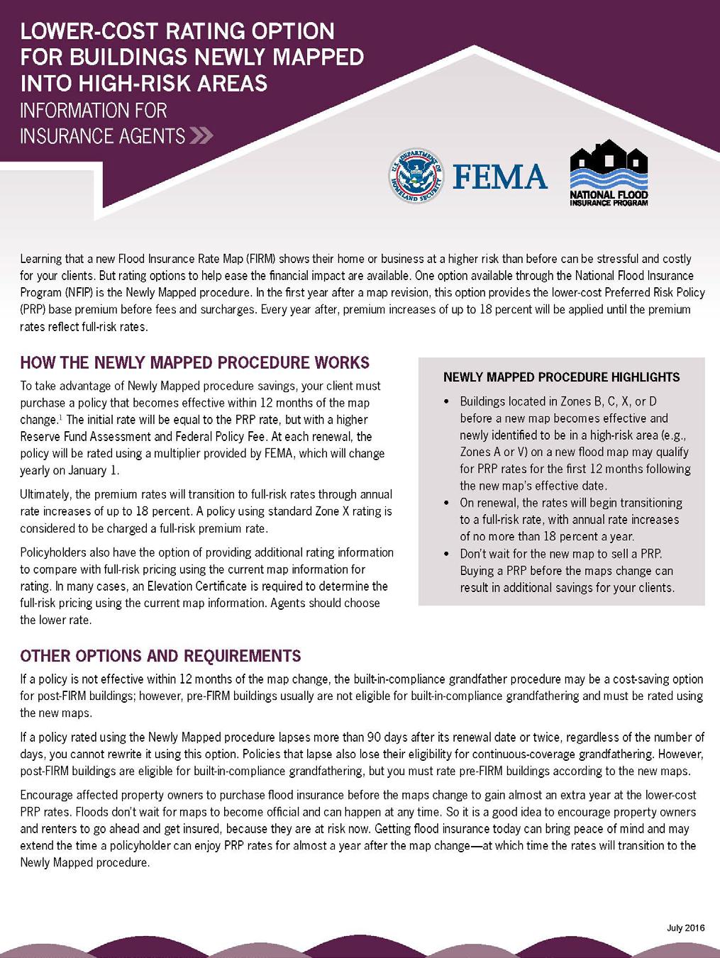
Pinellas County Flood Map Information Service & Real Estate Disclosure Program Training January 26, 2017 COMMON FLOODPLAIN ACRONYMS
|
|
|
- Lambert Bradford
- 5 years ago
- Views:
Transcription
1 FEMA ASFPM BFE CAV Pinellas County Flood Map Information Service & Real Estate Disclosure Program Training COMMON FLOODPLAIN ACRONYMS Federal Emergency Management Agency Association of State Floodplain Managers Base Flood Elevation Community Assistance Visit The Federal agency under which the NFIP is administered. In March 2003, FEMA became part of the newly created U.S. Department of Homeland Security. The elevation of surface water resulting from a flood that has a 1% chance of equaling or exceeding that level in any given year. The BFE is shown on the Flood Insurance Rate Map (FIRM) for zones AE, AH, A1 A30, AR, AR/A, AR/AE, AR/A1 A30, AR/AH, AR/AO, V1 V30 and VE. CBRA Coastal Barrier Resources Act (1982) The Coastal Barrier Resources Act (CBRA) established the Coastal Barrier Resources System (CBRS) designated certain portions of the Gulf and East Coasts as undeveloped coastal barriers. These areas are shown on appropriate flood insurance map panels and have certain coverage restrictions. CBIA Coastal Barrier Improvement Act (1990) New CBRS units and Otherwise Protected Areas (OPAs) were established (revised in 1996 and 1998) CBRRA Coastal Barrier Reauthorization Act (2000) Pilot project to determine the feasibility and cost of creating digital maps for the entire CBRS CFR CHHA CRS DFIRM EC FFE FFMA FHA FHBM FIRM FIS GIS H&H HAG LAG LOMA Code of Federal Regulations Coastal High Hazard Areas Community Rating System Digital Flood Insurance Rate Map Elevation Certificate Finished Floor Elevation Florida Floodplain Managers Association Flood Hazard Area Flood Hazard Boundary Map Flood Insurance Rate Map Flood Insurance Study Geographic Information System Hydrology and Hydraulics Highest Adjacent Grade Lowest Adjacent Grade Letter of Map Amendment Special Flood Hazard Areas (SFHAs) along the coasts that have additional hazards due to wind and wave action. These areas are identified on Flood Insurance Rate Maps (FIRMs) as zones V, V1-V30 and VE. A program developed by FEMA to provide incentives for those communities in the Regular Program that have gone beyond the minimum floodplain management requirements to develop extra measures to provide protection from flooding. Official map of a community issued by FEMA, where the boundaries of the flood, mudflow and related erosion areas having special hazards have been designated. Official map of a community on which FEMA has delineated the Special Flood Hazard Areas (SFHAs), the Base Flood Elevations (BFEs) and the risk premium zones applicable to the community. An amendment to the currently effective FEMA map which establishes that a property is not located in a Special Flood Hazard Area (SFHA). A LOMA is issued only by FEMA.
2 LOMR LOMR-F MSC Letter of Map Revision Pinellas County Flood Map Information Service & Real Estate Disclosure Program Training Letter of Map Revision-Fill Map Service Center NAVD North American Vertical Datum of 1988 NFIP National Flood Insurance Program NGVD National Geodetic Vertical Datum of 1929 OPA PRP SFHA Otherwise Protected Areas Preferred Risk Policy Special Flood Hazard Area Base Flood Enclosure Freeboard Grandfathering Lowest Floor Minimal flood hazard areas Moderate flood hazard areas Post-FIRM Building Pre-FIRM Building Repetitive Loss Structure An official amendment to the currently effective FEMA map. It is issued by FEMA and changes flood zones, delineations and elevations. The program of flood insurance coverage and floodplain management administered under the Act and applicable federal regulations promulgated in Title 44 of the Code of Federal Regulations, Subchapter B. National standard reference datum for elevations, formerly referred to as Mean Sea Level (MSL) of NGVD 1929 may be used as the reference datum on some Flood Insurance Rate Maps (FIRMs). Areas established under federal, state or local law or held by a qualified organization, primarily for wildlife refuge, sanctuary, recreational or natural resource conservation purposes. The only federal spending prohibition within OPAs is federal flood insurance. A lower-cost Standard Flood Insurance Policy (SFIP) written under the Dwelling Form or General Property Form. It offers fixed combinations of building/contents coverage limits or contents-only coverage. The PRP is available for property located in B, C and X Zones in Regular Program communities that meets eligibility requirements based on the property s flood loss history. It is also available for buildings that are eligible under the PRP Eligibility Extension. An area having special flood, mudflow or flood-related erosion hazards and shown on a Flood Hazard Boundary Map (FHBM) or a Flood Insurance Rate Map (FIRM) Zone A, AO, A1-A30, AE, A99, AH, AR, AR/A, AR/AE, AR/AH, AR/AO, AR/A1-A30, V1-V30, VE or V. For the purpose of determining Community Rating System (CRS) premium discounts, all AR and A99 zones are treated as non-sfhas. A flood having a 1% chance of being equaled or exceeded in any given year. That portion of an elevated building below the lowest elevated floor that is either partially or fully shut in by rigid walls An additional amount of height above the Base Flood Elevation used as a factor of safety (e.g., 2 feet above the Base Flood) in determining the level at which a structure's lowest floor must be elevated or floodproofed to be in accordance with state or community floodplain management regulations. An exemption based on circumstances previously existing. The lowest floor of the lowest enclosed area (including a basement). An unfinished or flood-resistant enclosure, usable solely for parking of vehicles, building access or storage in an area other than a basement area, is not considered a building's lowest floor provided that such enclosure is not built so as to render the structure in violation of requirements. Zone C or Zone X (unshaded); Areas outside the SFHA and higher than the elevation of the 0.2-percent-annual-chance flood Zone B or Zone X (shaded); Areas between the limits of the base flood and the 0.2-percent-annual-chance (or 500- year) flood A building for which construction or substantial improvement occurred after December 31, 1974 or on or after the effective date of an initial Flood Insurance Rate Map (FIRM), whichever is later. A building for which construction or substantial improvement occurred on or before December 31, 1974 or before the effective date of an initial Flood Insurance Rate Map (FIRM). An NFIP-insured structure that has had at least 2 paid flood losses of more than $1,000 each in any 10-year period since 1978.
3 CRS Ratings and Discounts *Data as of October 2017 Community Name County *Current CRS Class *Current CRS Discount Previous discount Amount change in October 2017 Belleair Pinellas 8 $44,414 Belleair Beach Pinellas 6 $369,792 $277,248 $92,544 Belleair Bluffs Pinellas 7 $5,569 Belleair Shore Pinellas 10 $0 Clearwater Pinellas 6 $1,854,543 Dunedin Pinellas 5 $1,044,053 Gulfport Pinellas 6 $355,673 Indian Rocks Beach Pinellas 6 $594,981 Indian Shores Pinellas 6 $400,496 Kenneth City Pinellas 8 $13,531 Largo Pinellas 7 $165,062 Madeira Beach Pinellas 6 $735,764 North Redington Beach Pinellas 7 $159,707 Oldsmar Pinellas 6 $362,580 Pinellas County Pinellas 5 $5,672,783 Pinellas Park Pinellas 6 $266,576 $193,001 $73,575 Redington Beach Pinellas 7 $217,785 Redington Shores Pinellas 7 $179,572 Safety Harbor Pinellas 7 $49,073 Seminole Pinellas 10 $0 South Pasadena Pinellas 7 $291,793 St. Pete Beach Pinellas 6 $1,779,359 St. Petersburg Pinellas 5 $10,203,640 Tarpon Springs Pinellas 7 $524,693 Treasure Island Pinellas 6 $1,187,515 TOTAL $26,478,954 $470,249 $166,119
4
5 Map Service and Brochure Practice ULMERTON ROAD, CLEARWATER US 19 N, CLEARWATER N RING AVE, TARPON SPRINGS SUNSET DR S, SOUTH PASADENA SOUTH FORT HARRISON AVE, CLEARWATER
REAL ESTATE FLOOD DISCLOSURE PROGRAM & FLOOD MAP INFORMATION SERVICES
 REAL ESTATE FLOOD DISCLOSURE PROGRAM & FLOOD MAP INFORMATION SERVICES Agenda 10:30-12:00 Flood Disclosure Program 12:00-12:30 Lunch 12:30-1:30 Flood Map Service Center Lisa Foster, CFM, Floodplain Coordinator
COMMUNITY RATING SYSTEM FLORIDA RESPONSE TO BW-12. Bryan W. Koon Director Division of Emergency Management
 COMMUNITY RATING SYSTEM FLORIDA RESPONSE TO BW-12 Bryan W. Koon Director Division of Emergency Management 2014 Biggert-Waters Reform Act 2012 Signed into law on July 6, 2012, reauthorizing the program
NFIP Mapping Issues. Wendy Lathrop, PLS, CFM. Cadastral Consulting, LLC
 NFIP Mapping Issues Cadastral Consulting, LLC NFIP Basic Objectives: Reduce the exposure to flood damages through the use of minimum standards for the placement and design of structures located in flood
JAXGIS FEMA Flood Hazard Mapping -- Frequently Asked Questions
 Flood Hazard Zone Designations Summary Zones starting with the letter 'A' (for instance, Zone A, Zone AE, Zone AH, Zone AO) denote a Special Flood Hazard Area, which can also be thought of as the 100-year
REAL ESTATE FLOOD DISCLOSURE PROGRAM & FLOOD MAP INFORMATION SERVICES
 REAL ESTATE FLOOD DISCLOSURE PROGRAM & FLOOD MAP INFORMATION SERVICES Lisa Foster, CFM, Floodplain Coordinator ldfoster@pinellascounty.org January 26, 2018 Why are you here? Save your clients money on
MOKAN CRS Users Group Activity 310, Elevation Certificates Packet
 http://mokan.stormsmart.org/ MOKAN CRS Users Group Activity 310, Elevation Certificates Packet This packet includes the following documents to be used as applicable to your community: EC checklist EC correction
Floodplain Management 101. Mississippi Emergency Management Agency Floodplain Management Bureau
 Floodplain Management 101 Mississippi Emergency Management Agency Floodplain Management Bureau Stafford Act The Stafford Disaster Relief and Emergency Assistance Act (Stafford Act) (Public Law 100-707)
Article 23-6 FLOODPLAIN DISTRICT
 AMENDING THE CODE OF THE CITY OF PITTSFIELD CHAPTER 23, ZONING ORDINANCE SECTION I That the Code of the City of Pittsfield, Chapter 23, Article 23-6 Floodplain District, shall be replaced with the following:
Introduction to the National Flood Insurance Program: A Guide for Coastal Property Owners MAINE BEACHES CONFERENCE 2017
 Introduction to the National Flood Insurance Program: A Guide for Coastal Property Owners MAINE BEACHES CONFERENCE 2017 SUE BAKER, CFM STATE NFIP COORDINATOR MAINE DEPT OF AGRICULTURE, CONSERVATION & FORESTRY
Questions about the National Flood Insurance Program
 Questions about the National Flood Insurance Program Federal Emergency Management Agency (FEMA) Questions and Answers What is the National Flood Insurance Program (NFIP)? The NFIP is a Federal program
10526 Bermuda Isle Dr. Tampa, FL 33647
 Flood Analysis Memo Property Address 10526 Bermuda Isle Dr. In Partnership with: ** This property is NOT within a high-risk flood zone ** 10526 Bermuda Isle Dr. BFE = 35 ft This property is located in
210 W Canal Dr Palm Harbor, FL 34684
 Flood Analysis Memo Property Address In Partnership with: ** This property is within a high risk flood zone ** BFE = 6 ft This property is located in the FEMA designated high-risk zone, Zone AE - an area
10526 Bermuda Isle Dr. Tampa, FL 33647
 Flood Analysis Memo Property Address In Partnership with: ** This property is NOT within a high-risk flood zone ** This property is located in a FEMA low-risk zone designated as Zone X - an area of minimal
a) Ensure public safety through reducing the threats to life and personal injury.
 Ensure public safety through reducing the threats to life and personal injury.") SECTION VII: FLOODPLAIN DISTRICT 7-1 Statement Of Purpose The purposes of the Floodplain District are to: a) Ensure public safety through reducing the threats to life and personal injury. b) Eliminate
SECTION VII: FLOODPLAIN DISTRICT 7-1 Statement Of Purpose The purposes of the Floodplain District are to: a) Ensure public safety through reducing the threats to life and personal injury. b) Eliminate
Flood Analysis Memo. 629 Orangewood Dr. Dunedin, FL BFE = 21 ft
 Flood Analysis Memo Property Address 629 Orangewood Dr. In Partnership with: ** This property is NOT within a high-risk flood zone ** 629 Orangewood Dr. BFE = 21 ft This property is located in the FEMA
National Flood Insurance Program Making Sense of April 2019 Changes
 National Flood Insurance Program Making Sense of April 2019 Changes Foreword The National Flood Insurance Program (NFIP) provides an important means for property owners to protect themselves financially
Kevin Wagner Maryland Department of the Environment
 Kevin Wagner Maryland Department of the Environment Topics Overview of the National Flood Insurance Program (NFIP) Mapping Regulations Insurance Mitigation Community Rating System (CRS) Questions Know
17.13 FLOOD DAMAGE PREVENTION ORDINANCE. Article I. Statutory Authorization, Findings of Fact, Purpose, and Methods
 17.13 FLOOD DAMAGE PREVENTION ORDINANCE Article I Statutory Authorization, Findings of Fact, Purpose, and Methods 17.1301 Statutory Authorization. The Legislature of the State of South Dakota has in (statutes)
Agenda. Introduction. Introduction -Map Study Lifecycle. Insurance Benefits of New Map
 Agenda Introduction Effects of Map Changes on Flood Insurance Lower risk to higher risk ( Grandfathering ) Higher risk to lower risk ( Conversion ) No Change Vertical Datum change Summary Levees Levees
De-Mystifying Grandfathering (and Other Flood Insurance Options) -What Floodplain Managers Should Know When Maps Change-
 -What Floodplain Managers Should Know When Maps Change-") De-Mystifying Grandfathering (and Other Flood Options) -What Floodplain Managers Should Know When Maps Change- ASFPM 2009 Annual Conference Orlando, FL June 11, 2009 Bruce A. Bender Services, Inc. Agenda
De-Mystifying Grandfathering (and Other Flood Options) -What Floodplain Managers Should Know When Maps Change- ASFPM 2009 Annual Conference Orlando, FL June 11, 2009 Bruce A. Bender Services, Inc. Agenda
ORDINANCE NO. 246 FLOOD DAMAGE PREVENTION ORDINANCE STATUTORY AUTHORIZATION, FINDINGS OF FACT, PURPOSE, AND OBJECTIVES
 ORDINANCE NO. 246 FLOOD DAMAGE PREVENTION ORDINANCE Article I. Section A. STATUTORY AUTHORIZATION, FINDINGS OF FACT, PURPOSE, AND OBJECTIVES Statutory Authority The Legislature of the State of Idaho, pursuant
SPECIAL CERTIFICATIONS
 SPECIAL CERTIFICATIONS This section presents detailed instructions for the completion of the National Flood Insurance Program (NFIP) Elevation Certificate (EC) and the NFIP Floodproofing Certificates.
FLOOD INSURANCE. Introduction
 FLOOD INSURANCE Introduction The purpose of this course is to provide a comprehensive description of the NFIP for insurance producers who are seeking continuing education credits. It provides an overview
ATTACHMENT A SUMMARY OF THE NFIP OCTOBER 2013 PREMIUM RATE AND RULE CHANGES
 ATTACHMENT A SUMMARY OF THE NFIP OCTOBER 2013 PREMIUM RATE AND RULE CHANGES National Flood Insurance Program October 1, 2013, Premium Rate and Rule Changes: A Summary 1. Premium Increases Premiums will
Enough about me! Topics Covered
 About Me Worked in land surveying since 1997 Employed by the City of Orlando since 2006 City of Orlando City Surveyor since February 2015 Certified Floodplain Manager since 2015 Florida Licensed Surveyor,
Preliminary DFIRM Community Coordination (PDCC) Meeting Gilchrist & Levy Counties, FL. April 30, 2015
 Meeting Gilchrist & Levy Counties, FL. April 30, 2015") Preliminary DFIRM Community Coordination (PDCC) Meeting Gilchrist & Levy Counties, FL April 30, 2015 Agenda 1. Introductions 2. Study Process and Timeline 3. Overview of Preliminary Products 4. Overview
Preliminary DFIRM Community Coordination (PDCC) Meeting Gilchrist & Levy Counties, FL April 30, 2015 Agenda 1. Introductions 2. Study Process and Timeline 3. Overview of Preliminary Products 4. Overview
ADVISORY BASE FLOOD ELEVATIONS (ABFEs)
") The Department of Homeland Security s Federal Emergency Management Agency is committed to helping communities that were impacted by Hurricanes Katrina and Rita rebuild safer and stronger. Following catastrophic
The Department of Homeland Security s Federal Emergency Management Agency is committed to helping communities that were impacted by Hurricanes Katrina and Rita rebuild safer and stronger. Following catastrophic
ATTACHMENT 1. Amendments to Chapter 18.20, Definitions Area of shallow flooding Area of special flood hazard
 Amendments to Chapter 18.20, Definitions 18.20.206 Area of shallow flooding Area of shallow flooding means a designated AO, or AH, AR/AO, AR/AH, or VO Zone on the a community's flood insurance rate map
FLOOD DAMAGE PREVENTION RULES
 60.3(d) FLOOD DAMAGE PREVENTION RULES ARTICLE 1 STATUTORY AUTHORIZATION, FINDINGS OF FACT, PURPOSE AND METHODS SECTION A. STATUTORY AUTHORIZATION The Legislature of the State of Texas adopted the Flood
REAL ESTATE FLOOD DISCLOSURE PROGRAM & FLOOD MAP INFORMATION SERVICES
 REAL ESTATE FLOOD DISCLOSURE PROGRAM & FLOOD MAP INFORMATION SERVICES Lisa Foster, CFM, Floodplain Coordinator ldfoster@pinellascounty.org January 26, 2018 Why are you here? Save your clients money on
Floodplain Management 101: UNIT II. Maps & Flood Insurance Studies
 Floodplain Management 101: UNIT II Maps & Flood Insurance Studies Who is ASFPM? ASFPM stands for the Association of State Floodplain Managers A national organization of floodplain management professionals
COLLIER COUNTY FLOODPLAIN MANAGEMENT
 COLLIER COUNTY FLOODPLAIN MANAGEMENT FREQUENTLY ASKED QUESTIONS The following information is based on common questions from the public. If you have a specific question or need further information, please
National Flood Insurance Program (NFIP) for Real Estate Professionals
 for Real Estate Professionals") National Flood Insurance Program (NFIP) for Real Estate Professionals 1 Joshua Oyer, CFM Outreach Specialist NFIP State Coordinator s Office at the Texas Water Development Board 2 Outline Introduction
National Flood Insurance Program (NFIP) for Real Estate Professionals 1 Joshua Oyer, CFM Outreach Specialist NFIP State Coordinator s Office at the Texas Water Development Board 2 Outline Introduction
Oak Island 1999 Hurricane Floyd
 Oak Island 1999 Hurricane Floyd Topics to be Discussed What is a flood zone Flood zones in Oak Island Special Flood Hazard Areas (SFHA) Flood insurance Base Flood Elevations (BFEs) Building in flood zones
Key Fundamentals of Flood Insurance
 a Welcome to Key Fundamentals of Flood Insurance An entry-level approach for real estate professionals [Photo credit: Oliver Gruener] We will get started in a few minutes. Presented Meanwhile, by: let
W October 1, Write Your Own (WYO) Principal Coordinators and the National Flood Insurance Program (NFIP) Servicing Agent
 Principal Coordinators and the National Flood Insurance Program (NFIP) Servicing Agent") U.S. Department of Homeland Security 500 C St. SW Washington, D.C. 20472 W-14053 October 1, 2014 MEMORANDUM FOR: Write Your Own (WYO) Principal Coordinators and the National Flood Insurance Program (NFIP)
U.S. Department of Homeland Security 500 C St. SW Washington, D.C. 20472 W-14053 October 1, 2014 MEMORANDUM FOR: Write Your Own (WYO) Principal Coordinators and the National Flood Insurance Program (NFIP)
CONTRA COSTA COUNTY FLOODPLAIN MANAGEMENT PROGRAM
 CONTRA COSTA COUNTY FLOODPLAIN MANAGEMENT PROGRAM Answers to Commonly Asked Questions and A Guide for Residential Construction Within Special Flood Hazard Areas Revised February 2015 Introduction Ninety
The National Flood Insurance Program. Introduction Section I
 Introduction Section I Course Material The following course material reflects input gathered by FEMA (Federal Emergency Management Agency) from state insurance regulators, insurers that sell flood insurance
North Carolina Department of Public Safety Emergency Management Risk Management
 North Carolina Department of Public Safety Emergency Management Risk Management Roy Cooper, Governor Erik A. Hooks, Secretary Michael A. Sprayberry, Director INSTRUCTIONS FOR COMPLETING THE NORTH CAROLINA
Updates to Maine Coastal Flood Insurance Rate Maps (FIRM s): What a Local Official Should Know. Presented by: Steve Johnson, P.E.
: What a Local Official Should Know. Presented by: Steve Johnson, P.E.") Updates to Maine Coastal Flood Insurance Rate Maps (FIRM s): What a Local Official Should Know Presented by: Steve Johnson, P.E. Town Engineer October 4, 2018 Introduction Federal Emergency Management
Updates to Maine Coastal Flood Insurance Rate Maps (FIRM s): What a Local Official Should Know Presented by: Steve Johnson, P.E. Town Engineer October 4, 2018 Introduction Federal Emergency Management
ORDINANCE # FLOOD DAMAGE PREVENTION ORDINANCE STATUTORY AUTHORIZATION, FINDINGS OF FACT, PURPOSE AND METHODS
 ORDINANCE # 304 - FLOOD DAMAGE PREVENTION ORDINANCE ARTICLE I STATUTORY AUTHORIZATION, FINDINGS OF FACT, PURPOSE AND METHODS SECTION A. STATUTORY AUTHORIZATION The Legislature of the State of South Dakota
National Flood Insurance Program, Biggert-Waters 2012, and Homeowners Flood Insurance Affordability Act 2014
 National Flood Insurance Program, Biggert-Waters 2012, and Homeowners Flood Insurance Affordability Act 2014 Janice Mitchell, Insurance Specialist Floodplain Management and Insurance Branch FEMA Region
National Flood Insurance Program and Biggert-Waters 2012
 National Flood Insurance Program and Biggert-Waters 2012 National Flood Insurance Program NFIP was created by Congress in 1968 Coverage underwritten by the Federal Government, administered by FEMA NFIP
NESHOBA COUNTY, MISSISSIPPI FLOOD DAMAGE PREVENTION ORDINANCE
 NESHOBA COUNTY, MISSISSIPPI FLOOD DAMAGE PREVENTION ORDINANCE January 22, 2019 NESHOBA COUNTY, MISSISSIPPI FLOOD DAMAGE PREVENTION ORDINANCE TABLE OF CONTENTS ARTICLE 1. STATUTORY AUTHORIZATION, FINDINGS
Flood Insurance for Local Officials and Floodplain Managers. What Every Community Official Needs to Know About Flood Insurance
 Flood Insurance for Local Officials and Floodplain Managers What Every Community Official Needs to Know About Flood Insurance Illinois Association for Floodplain and Stormwater Management 2011 Annual Conference
DELTA COUNTY FLOOD DAMAGE PREVENTION REGULATIONS CERTIFIED BY THE. Delta County Planning Commission September 26, 2013 ADOPTED BY THE
 DELTA COUNTY FLOOD DAMAGE PREVENTION REGULATIONS CERTIFIED BY THE Delta County Planning Commission September 26, 2013 ADOPTED BY THE Board of Delta County Commissioners December 9, 2013 REVISED BY THE
Model B E. Flood Damage Prevention Ordinance 4/11
 Model B E Flood Damage Prevention Ordinance 4/11 The following information is provided to assist you in developing an ordinance that will comply with the minimum participating criteria of the National
Federal Emergency Management Agency
 Page 1 of 3 COMMUNITY AND MAP PANEL INFORMATION COMMUNITY CITY OF MARGATE CITY, ATLANTIC COUNTY, NEW JERSEY LEGAL PROPERTY DESCRIPTION A parcel of land, as described in Deed recorded in Book 4826, page
AMENDMENTS TO CHAPTER 50: FLOODPLAIN DEVELOPMENT
 AMENDMENTS TO CHAPTER 50: FLOODPLAIN DEVELOPMENT PART I: 2018 FLOOD MAP IMPLEMENTATION PART II: STRATEGIES TO IMPROVE THE CITY S COMMUNITY RATING SYSTEM SCORE NATIONAL FLOOD INSURANCE PROGRAM (NFIP) CREATED
Floodplain Development Permit Application
 Floodplain Development Permit Application City of Jonesboro, AR This is an application packet for a Floodplain Development Permit. Certain sections are to be completed by the Applicant, and certain sections
April 2, Write Your Own Principal Coordinators and the NFIP Servicing Agent
 U.S. Department of Homeland Security 500 C Street, SW Washington, DC 20472 W-09021 April 2, 2009 MEMORANDUM TO: Write Your Own Principal Coordinators and the NFIP Servicing Agent FROM: SUBJECT: Edward
Flood Insurance Information for Prospective Buyers
 Flood Insurance Information for Prospective Buyers 25. Who may purchase a flood insurance policy? NFIP coverage is available to all owners of eligible property (a building and/or its contents) located
History of Floodplain Management in Ascension Parish
 History of Floodplain Management in Ascension Parish presented by: Kara Moree Floodplain Coordinator February 6, 2012 Floodplain 101 Floodplain 101 Base or 1% Flood: A flood having a 1% chance of being
Door County Floodplain Program Informational Meeting
 Door County Floodplain Program Informational Meeting Door County Land Use Services Department Wisconsin Department of Natural Resources January 15, 2018 Floodplain = Land affected by flood event with a
F E M A Mapping Changes. FEMA Mapping Changes. National Flood Insurance Program
 FEMA Mapping Changes National Flood Insurance Program 1 Welcome to FEMA Mapping Changes! We will get started in a few minutes. Meanwhile, let s perform a warm up exercise. 2 1 Training Agenda Section 1-
Using GISWeb to Determine Your Property s Flood Zone
 Using GISWeb to Determine Your Property s Flood Zone 1. In a new browser window, go to http://www.co.santacruz.ca.us/departments/geographicinformationsystemsgis.aspx 2. Click on GISWeb - GIS Mapping Application
Nassau County, Florida Consultation Coordination Officer (CCO) Meeting. February 24, 2016 Fernandina Beach, Florida
 Meeting. February 24, 2016 Fernandina Beach, Florida") Nassau County, Florida Consultation Coordination Officer (CCO) Meeting February 24, 2016 Fernandina Beach, Florida Agenda Introductions Coastal Study Update Study Process and Timeline Flood Insurance Implications
Nassau County, Florida Consultation Coordination Officer (CCO) Meeting February 24, 2016 Fernandina Beach, Florida Agenda Introductions Coastal Study Update Study Process and Timeline Flood Insurance Implications
FLOOD DAMAGE PREVENTION REGULATION ARTICLE I STATUTORY AUTHORIZATION, FINDINGS OF FACT, PURPOSE AND OBJECTIVES
 CHAPTER 12 FLOOD DAMAGE PREVENTION REGULATION ARTICLE I STATUTORY AUTHORIZATION, FINDINGS OF FACT, PURPOSE AND OBJECTIVES SECTION A. STATUTORY AUTHORIZATION The Legislature of the State of Colorado has,
Floodplain Development Permit Application
 Floodplain Development Permit Application **All construction will also require a building permit** This is an application packet for a Floodplain Development Permit. Certain sections are to be completed
Flood Map Revisions. Town of Nags Head Public Information and Input Session. December 14, 2016, 6 pm
 Flood Map Revisions Town of Nags Head Public Information and Input Session December 14, 2016, 6 pm Flood Map Revisions New preliminary flood maps released for Dare County June 30, 2016 www.nagsheadnc.gov/floodmaps
Skagit County Flood Insurance Study Update. Ryan Ike, CFM FEMA Region 10
 Skagit County Flood Insurance Study Update Ryan Ike, CFM FEMA Region 10 Skagit County Flood Insurance Study Process Overview Process, Schedule, & Deliverables Base Flood Elevations, Modeling, & Levees
Florida Division of Emergency Management
 2017 FLOODPLAIN MANAGEMENT IN FLORIDA Florida Division of Emergency Management Bureau of Mitigation State Floodplain Management Office 2555 Shumard Oak Boulevard, Tallahassee, FL 32399 www.floridadisaster.org/mitigation
Appendix D - Floodplain Documents
 City of Aspen Urban Runoff Management Plan Appendix D - Floodplain Documents 1. Floodplain Development Permit 2. Elevation Certificate and Instructions 3. Floodproofing Certificate for Non-Residential
Federal Emergency Management Agency
 Page 1 of 4 Issue Date: April 11, 2013 Case No.: DETERMINATION DOCUMENT COMMUNITY AND REVISION INFORMATION PROJECT DESCRIPTION BASIS OF REQUEST Town Of Stratford Fairfield County Connecticut NO PROJECT
National Flood Insurance Program. Jennifer Gilbert, CFM, ANFI New Hampshire NFIP State Coordinator
 National Flood Insurance Program Jennifer Gilbert, CFM, ANFI New Hampshire NFIP State Coordinator What is the National Flood Insurance Program? Created by Congress in 1968 Participating Communities voluntarily
National Flood Insurance Program
 National Flood Insurance Program FEMA ELEVATION CERTIFICATES PA Surveyor Training Presented by Thomas F. Smith, PE, PLS January 22, 2018 1 FEMA Region III Mitigation Division Floodplain Management & Insurance
NFIP Overview Elevation Certificate Flood Insurance Rate Maps. By: Maureen O Shea, AICP, CFM State NFIP Coordinator
 NFIP Overview Elevation Certificate Flood Insurance Rate Maps By: Maureen O Shea, AICP, CFM State NFIP Coordinator Example of a flood failure Example of a flood failure Purposes of the NFIP Identify &
Federal Emergency Management Agency
 Page 1 of 4 Issue Date: September 7, 2012 Effective Date: January 22, 2013 DETERMINATION DOCUMENT COMMUNITY COMMUNITY AND REVISION INFORMATION City of Lubbock Lubbock County Texas PROJECT DESCRIPTION CHANNELIZATION
Changes Coming to the National Flood Insurance Program What to Expect. Impact of changes to the NFIP under Section 205 of the Biggert-Waters Act
 Changes Coming to the National Flood Insurance Program What to Expect Impact of changes to the NFIP under Section 205 of the Biggert-Waters Act Flood Risk Flood risks and the costs of flooding Weather
AN ORDINANCE RELATING TO FLOOD DAMAGE PREVENTION FOR. Hardin County, Kentucky. August 14, 2007
 Commonwealth of Kentucky AN ORDINANCE RELATING TO FLOOD DAMAGE PREVENTION FOR Hardin County, Kentucky August 14, 2007 ACKNOWLEDGEMENT Thanks to Kentucky Division of Water Water Resources Branch Floodplain
ORDINANCE NO A FLOOD DAMAGE PREVENTION ORDINANCE
 ORDINANCE NO. 692-14 A FLOOD DAMAGE PREVENTION ORDINANCE WHEREAS, for a community to participate in the National Flood Insurance Program NFIP, it must adopt and enforce floodplain management regulations
SECTION 9: MAPS AND DATA
 SECTION 9: MAPS AND DATA Contents 9.1. NFIP Maps and Data... 9-2 9.1.1. Adopting and enforcing NFIP floodplain maps and data... 9-2 9.1.2. Adopting and enforcing more restrictive data... 9-2 9.1.3. Annexations...
Dealing With Unnumbered A Zones in Maine Floodplain Management
 Dealing With Unnumbered A Zones in Maine Floodplain Management The following is a list of acceptable methods that the State Floodplain Management Coordinator and the Federal Emergency Management Agency
Kentucky Floodplain Administrators Handbook
 Kentucky Floodplain Administrators Handbook A Guide for Local Permitting Officials This handbook is published by the Floodplain Management Section of the Department for Environmental Protection, Division
Durham County Preliminary Flood Hazard Data Public Meeting. July 28, 2016
 Durham County Preliminary Flood Hazard Data Public Meeting July 28, 2016 Why Are We Here New flood hazard data has been released as Preliminary for Durham County Statutory Due Process for review/comments
CHAPTER 156: FLOOD DAMAGE PREVENTION. General Provisions
 CHAPTER 156: FLOOD DAMAGE PREVENTION Section General Provisions 156.01 Statutory authorization, findings of fact, purpose, objectives 156.02 Definitions 156.03 Lands to which this chapter applies 156.04
Changes to the National Flood Insurance Program: From Biggert to Grimm Waters. Click to edit Master title style. Click to edit Master subtitle style
 Changes to the National Flood Insurance Program: Click to edit Master title style From Biggert to Grimm Waters Click to edit Master subtitle style Thomas Ruppert Coastal Planning Specialist With thanks
ORDINANCE NO. 2 Series 2013 TOWN OF PITKIN FLOODPLAIN DAMAGE PREVENTION ORDINANCE
 ORDINANCE NO. 2 Series 2013 TOWN OF PITKIN FLOODPLAIN DAMAGE PREVENTION ORDINANCE FLOOD DAMAGE PREVENTION ORDINANCE TABLE OF CONTENTS ARTICLE I - TITLE AND PURPOSE... 1 SECTION A. STATUTORY AUTHORIZATION...
Federal Emergency Management Agency
 Page 1 of 4 Issue Date: October 2, 2017 Effective Date: October 2, 2017 Case No.: 17-09-2731P LOMR-APP Federal Emergency Management Agency Washington, D.C. 20472 LETTER OF MAP REVISION DETERMINATION DOCUMENT
Role of the Local Floodplain Administrator
 2/22/2016 Role of the Local Floodplain Administrator Marsha Hilmes-Robinson Floodplain Administrator City of Fort Collins, Colorado mhilmesrobinson@fcgov.com 1 Partnership Engineer/Architect/ Contractor
Federal Emergency Management Agency
 Page 1 of 4 Issue Date: February 14, 2013 Effective Date: June 28, 2013 DETERMINATION DOCUMENT COMMUNITY AND REVISION INFORMATION City of Sunny Isles Beach Miami-Dade County Florida PROJECT DESCRIPTION
National Flood Insurance Program Changes Effective April 1, 2016
 National Flood Insurance Program Changes Effective April 1, 2016 Beginning April 1, 2016, the National Flood Insurance Program (NFIP) will begin implementing additional flood insurance program changes
PARK COUNTY, WYOMING AND INCORPORATED AREAS
 PARK COUNTY, WYOMING AND INCORPORATED AREAS Community Name Community Number CODY, CITY OF 560038 MEETEETSE, TOWN OF 560039 PARK COUNTY UNINCORPORATED AREAS 560085 POWELL, CITY OF 560040 June 18, 2010 Federal
YOLO COUNTY FLOODPLAIN MANAGEMENT PROGRAM
 YOLO COUNTY FLOODPLAIN MANAGEMENT PROGRAM Answers to Commonly Asked Questions and A Guide for Residential Construction Within Special Flood Hazard Areas The automatic entry and exit of flood water); Or
What Was Updated in 2004 in Hennepin Countywide Maps?
 What Was Updated in 2004 in Hennepin Countywide Maps? Combined the city and township maps into one countywide index Done by USACE Mainly digital capture of old floodplain boundaries; some spots with shifts
October 1, Write Your Own (WYO) Principal Coordinators and the National Flood Insurance Program (NFIP) Servicing Agent
 Principal Coordinators and the National Flood Insurance Program (NFIP) Servicing Agent") U.S. Department of Homeland Security Washington, D.C. 20472 October 1, 2015 MEMORANDUM FOR: Write Your Own (WYO) Principal Coordinators and the National Flood Insurance Program (NFIP) Servicing Agent FROM:
U.S. Department of Homeland Security Washington, D.C. 20472 October 1, 2015 MEMORANDUM FOR: Write Your Own (WYO) Principal Coordinators and the National Flood Insurance Program (NFIP) Servicing Agent FROM:
11/18/2011. FEMA All rights reserved. FEMA All rights reserved. Session Overview
 3 Session Overview 4 1 Welcome to Session 2 of the FEMA NFIP Agent Training Program! Dorothy Martinez Rich Slevin Recall your learning from the previous session and share at least one important takeaway.
REGION X FLOOD DAMAGE PREVENTION ORDINANCE WASHINGTON MODEL (REVISED 5/13/2004)
") REGION X FLOOD DAMAGE PREVENTION ORDINANCE WASHINGTON MODEL (REVISED 5/13/2004) Close to 300 towns, cities, counties, and tribes within the State of Washington participate in the National Flood Insurance
REGION X FLOOD DAMAGE PREVENTION ORDINANCE WASHINGTON MODEL (REVISED 5/13/2004) Close to 300 towns, cities, counties, and tribes within the State of Washington participate in the National Flood Insurance
FLOOD HAZARD AREA REGULATION TOWN OF GLOVER, VERMONT. Adopted by the Glover Board of Selectmen on June 27, 1991
 FLOOD HAZARD AREA REGULATION TOWN OF GLOVER, VERMONT Adopted by the Glover Board of Selectmen on June 27, 1991 1 TOWN OF GLOVER, VERMONT FLOOD HAZARD AREA REGULATIONS Table of Contents Sec 101: Statutory
Herkimer County, New York Flood Hazard Mapping Status Report for Property Owners
 Herkimer County, New York Flood Hazard Mapping Status Report for Property Owners Herkimer County, New York Flood Hazard Mapping Status Report for Property Owners FLOOD INSURANCE Who Should Purchase Flood
If you have any questions or concerns please give us a call at , or Walter Jenkins at (ext 300).
.") FLORIDA ZONE SERVICES Flood Insurance and Zone Consulting 461 SE 3 rd Terrace Pompano Beach, FL 33060 Phone 954-290-7420 bspencer@florida-floodzone.com March 6, 2014 Dear Pebblebrook II Homeowner: We informing
FLORIDA ZONE SERVICES Flood Insurance and Zone Consulting 461 SE 3 rd Terrace Pompano Beach, FL 33060 Phone 954-290-7420 bspencer@florida-floodzone.com March 6, 2014 Dear Pebblebrook II Homeowner: We informing
National Flood Insurance Program (NFIP) and Flood Insurance Rate Map (FIRM) San Francisco Port Commission. October 23, 2007
 and Flood Insurance Rate Map (FIRM) San Francisco Port Commission. October 23, 2007") National Flood Insurance Program (NFIP) and Flood Insurance Rate Map (FIRM) San Francisco Port Commission October 23, 2007 Flood Insurance Rate Map (FIRM) FEMA manages the NFIP using a nationwide system
National Flood Insurance Program (NFIP) and Flood Insurance Rate Map (FIRM) San Francisco Port Commission October 23, 2007 Flood Insurance Rate Map (FIRM) FEMA manages the NFIP using a nationwide system
Appendix B. A Comparison of the Minimum NFIP Requirements and the CRS
 A Comparison of the Minimum s and the CRS The Community Rating System provides credits for exceeding the minimum requirements of the National Flood Insurance Program (NFIP). Many local officials are not
May 5, Write Your Own (WYO) Principal Coordinators and the National Flood Insurance Program (NFIP) Servicing Agent
 Principal Coordinators and the National Flood Insurance Program (NFIP) Servicing Agent") U.S. Department of Homeland Security 500 C Street, SW Washington, DC 20472 W-13026 May 5, 2013 MEMORANDUM FOR: Write Your Own (WYO) Principal Coordinators and the National Flood Insurance Program (NFIP)
U.S. Department of Homeland Security 500 C Street, SW Washington, DC 20472 W-13026 May 5, 2013 MEMORANDUM FOR: Write Your Own (WYO) Principal Coordinators and the National Flood Insurance Program (NFIP)
ATTACHMENT A SUMMARY OF THE NFIP PROGRAM CHANGES EFFECTIVE APRIL 1, 2018 AND JANUARY 1, 2019
 ATTACHMENT A SUMMARY OF THE NFIP PROGRAM CHANGES EFFECTIVE APRIL 1, 2018 AND JANUARY 1, 2019 National Flood Insurance Program April 1, 2018 and January 1, 2019 Program Changes: A Summary The changes outlined
Bullitt County, Kentucky Preliminary DFIRM Community Open House. October 8, 2014 Shepherdsville, Kentucky
 Bullitt County, Kentucky Preliminary DFIRM Community Open House October 8, 2014 Shepherdsville, Kentucky Meeting Agenda Introductions Overview of Preliminary DFIRMs Overview of Map Appeal Process Questions
Chapter 6 - Floodplains
 Chapter 6 - Floodplains 6.1 Overview The goal of floodplain management is to reduce the potential risks to both existing and future developments, and infrastructure, in the 100-year floodplain. Over the
Taylor County, Florida Community Coordination and Outreach (CCO) Meeting
 Meeting") Taylor County, Florida Community Coordination and Outreach (CCO) Meeting Suwannee River Water Management District April 26, 2017 11:00AM to 12:00PM Taylor County Administration Building, 201 E. Green Street,
Taylor County, Florida Community Coordination and Outreach (CCO) Meeting Suwannee River Water Management District April 26, 2017 11:00AM to 12:00PM Taylor County Administration Building, 201 E. Green Street,
Community Coordination Meeting Sagadahoc County, Maine
 Community Coordination Meeting Sagadahoc County, Maine Risk MAP Study April 2, 2014 Agenda Welcome and Introductions Project Timeline Flood Hazard Analysis Recap Flood Risk Products Action: Hazard Mitigation
Requirements for Construction on Properties in the Special Flood Hazard Area (SFHA)
") Requirements for Construction on Properties in the Special Flood Hazard Area (SFHA) Rev 010915 The website for the IDNR to request the EFARA (Electronic Floodplain Analysis/Regulatory Assessment is found
Requirements for Construction on Properties in the Special Flood Hazard Area (SFHA) Rev 010915 The website for the IDNR to request the EFARA (Electronic Floodplain Analysis/Regulatory Assessment is found