F E M A Mapping Changes. FEMA Mapping Changes. National Flood Insurance Program
|
|
|
- Sandra Spencer
- 6 years ago
- Views:
Transcription


1 FEMA Mapping Changes National Flood Insurance Program 1 Welcome to FEMA Mapping Changes! We will get started in a few minutes. Meanwhile, let s perform a warm up exercise. 2 1

2 Training Agenda Section 1- EVOLUTION of flood maps Section 2- PROCESS of flood mapping Section 3- RESOURCES for finding flood maps Section 4- BENEFITS of updated flood maps Section 5- IMPACTS of mapping changes Section 6- IMPLEMENTATION issues for agents and lenders Section 7- CHALLENGES to the flood maps 3 Section 1 EVOLUTION of flood maps 4 2
3 Evolution How do we get to where we are going? FHBM FIRM DFIRM 5 Evolution FEMA Mapping Flood Hazard Boundary Map (FHBM) Flood Insurance Rate Map (FIRM) Digital Flood Insurance Rate Map (DFIRM) 6 3


4 Evolution FEMA Mapping FEMA Map Modernization FEMA Risk MAP 7 Section 2 PROCESS of flood mapping 8 4
5 Process FEMA Mapping Changes Processing the Process Adoption Stakeholder, Media & Public Outreach Project Scoping or Discovery Initial Involvement Preliminary Release Stakeholder, Media & Public Outreach Data/Map Development Stakeholder Outreach 10 Section 3 RESOURCES for finding flood maps 11 5

 AE (replaces")
 V, VO")
6 Don t hesitate to be resourceful! 12 Flood Zone Designations High Risk (SFHA) AE (replaces A1-A30) A, AH, AO, A99, AR VE (replaces V1-V30) V, VO Moderate to Low Risk B, C, X 13 6

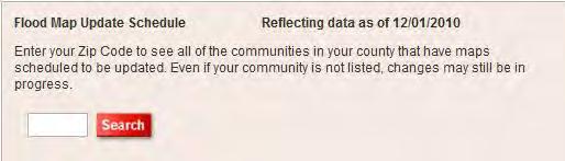
7 Flood Zone Designations 100-Year Floodplain 1-percent chance of being flooded in any given year (base flood). At least 26% chance of flooding over a 30 year mortgage 14 Finding FEMA Map Changes For Finding Map Changes Map Service Center FloodSmart website Community Status Book* Click Here *Community Status Book
8 Visit the Map Service Center


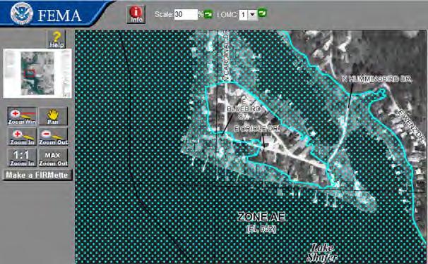
9 FEMA Map Service Center 18 FEMA Map Service Center 19 9


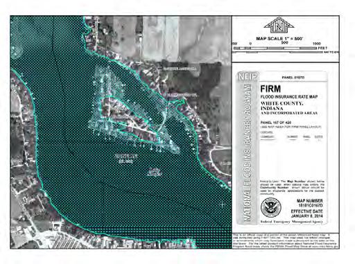
10 FEMA Map Service Center Flood Insurance Rate Map 20 FEMA Map Service Center FIRMETTE 21 10

11 FEMA Map Service Center 22 FEMA Map Service Center 23 11


12 FEMA Map Service Center 24 FEMA Map Service Center 25 12
13 FEMA Map Service Center


14 FEMA Map Service Center 28 FEMA Map Service Center 29 14


15 Locating Historic Flood Maps 30 Locating Historic Flood Maps 31 15

16 Locating Historic Flood Maps 32 Locating Historic Flood Maps 33 16

17 Finding FEMA Map Changes For Finding Map Changes Map Service Center FloodSmart website Community Status Book* Click Here *Community Status Book
18


19 38 Topic 1: The National Flood Insurance Program


20 Topic 1: The National Flood Insurance Program 40 Finding FEMA Map Changes For Finding Map Changes Map Service Center FloodSmart website Community Status Book* Click Here *Community Status Book

21 Community Status Book 42 Community Status Book 43 21


22 Defining Pre-FIRM and Post-FIRM Pre-FIRM Built before initial FIRM or On or before 12/31/1974 Post-FIRM On or After the initial FIRM or After 12/31/ whichever is LATER 44 Community Status Book 45 22


23 Section 4 BENEFITS of updated flood maps 47 Benefits Each new benefit is more beneficial than the one before. Risk Identity Accuracy Informed Decisions 48 23

 Provides for more accurate rating")

. 50 24")
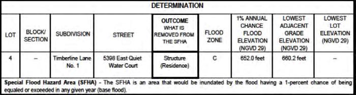
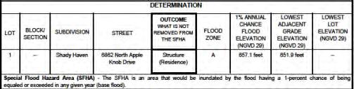
24 Benefits Insurance Benefits of New Maps Identifies current flood hazard risks Better delineates Base Flood Elevations (BFEs) Provides for more accurate rating Allows property owners to make more informed decisions 49 Benefits Insurance Benefits of New Maps SFHAs appear as dark shading on a Flood Insurance Rate Map (FIRM)


25 Benefits Insurance Benefits of New Maps SFHAs appear as aqua dotted area on the Digital Flood Insurance Rate Map (DFIRM). 51 Section 5 IMPACTS of mapping changes 52 25


26 Impacts Every flood makes a big impact on someone. 53 Impacts Properties Moving into Special Flood Hazard Areas Enter SFHA Mandatory Purchase of Flood Insurance Required? 54 26


27 Impacts Properties Removed From Special Flood Hazard Areas Exit SFHA Eligible for Low-Cost Preferred Risk Policy 55 Impacts Mapped In Flood risk increased More structures in floodplain Mandatory purchase of flood insurance Mapped Out Flood risk reduced Risk not eliminated Low-cost preferred risk coverage available Keep coverage Lower cost 56 27
28 Impacts What is a Preferred Risk Policy (PRP)? Low-Cost Flood Policy B, C & X Zones Building/Contents Combinations Loss eligibility Premium Comparisons* $200,000 Bldg $80,000 Contents Pre-FIRM AE Zone $3,321 Post-FIRM +1 AE Zone $945 Standard X Zone $1,908 PRP in B, C, X zone $405 * Single family, one floor, no basement, minimum deductible (4/1/15 rates) 57 Section 6 IMPLEMENTATION issues for stakeholders 59 28


29 Implementation Making it all work together Lender Agent Property Owner 60 Implementation Insurance Agent Implementation Issues Importance of identifying properties affected by map change Significance of understanding rating options available Rating options that may apply: Grandfather rating rules Newly Mapped Procedure 62 29

30 Implementation Rating Options Following a Map Revision 4/01/2015 GRANDFATHER RATING RULES PRP ELIGIBILITY EXTENSION NEWLY MAPPED 10/01/2008 PROCEDURE until further notice 63 Implementation Grandfathering Allows premium benefits after Changes in map zones Changes to compliance standards May provide legitimate reason for zone discrepancies on policy declarations page 64 30


31 Implementation Grandfathering Allows a property owner to: Lock in a previous Flood Zone Lock in a previous Base Flood Elevation 65 Implementation Grandfathering Continuous Coverage For policy in effect prior to map change date, maintain prior zone and BFE Coverage must be continuous 66 31


32 Implementation Grandfathering Built In Compliance If building was constructed in compliance with a specific FIRM, use that map s zone and BFE Submit proof to carrier Continuous coverage not required 67 Implementation Rating Options Following a Map Revision 4/01/2015 GRANDFATHER RATING RULES PRP ELIGIBILITY EXTENSION NEWLY MAPPED 10/01/2008 PROCEDURE until further notice 68 32
33 F E M A M a p p i n g C h a n g e s Implementation Newly Mapped Procedure Effective April 1, 2015 PRP Eligibility Extension transitioned to Newly Mapped Procedure Properties newly mapped into SFHA receive a preferred risk premium for first year after map revision Identical to the Preferred Risk Policy premium before application of: Reserve Fund Assessment Federal Policy Fee After first year, policies transition to full-risk rates via premium increases subject to the 18% limitation 69 Implementation Newly Mapped Procedure Newly Mapped on or after April 1, 2015 F E M A M a p p i n g C h a n g e s Eligible for Newly Mapped Procedure If coverage obtained within 12 months of map revision Preferred risk premium first year Not eligible for Newly Mapped Procedure If coverage not obtained within 12 months of map change Only eligible for grandfathering to zone and/or BFE in effect at time of construction Within 12 months of map revision NOTE: All Properties must meet Preferred Risk Policy loss requirements to be eligible for Newly Mapped Procedure 70 33
34 F E M A M a p p i n g C h a n g e s Implementation Newly Mapped Procedure Newly Mapped between: October 1, 2008 and March 31, 2015 Oct 1, 2008 Newly Mapped between Mar 31, 2015 Eligible for Newly Mapped Procedure If coverage obtained before April 1, 2016 Properties eligible under the PRP Eligibility Extension (PRPEE) Policies issued under PRPEE before 4/1/15: Renew under Newly Mapped Procedure on first effective date on or after April 1, 2015 Coverage must be purchased BEFORE Apr 1, 2016 NOTE: All Properties must meet Preferred Risk Policy loss requirements to be eligible for Newly Mapped Procedure 71 Implementation Lending Community Issues How do lenders know maps have changed? Portfolio reviews required? Life of loan flood zone determinations Process for requiring flood insurance Borrower notification 45 day letter Force Placement 73 34
35 Implementation Lending Community Issues What happens once the policy arrives? Lender verifies compliance issues Resolves flood zone discrepancies What is a flood zone discrepancy? Lender determination and policy declaration have different flood zones SFHA vs. Non-SFHA discrepancies Unless Grandfather Rating Rules or Newly Mapped Procedure apply 74 Implementation Flood Zones on Declarations Pages Current Flood Zone flood zone of property on current (revised) Flood Insurance Rate Map (FIRM) Flood Risk/Rated Zone flood zone from the previous map used to rate policy Lenders are not required to investigate or resolve differences between Current Flood Zone and Flood Risk/Rated Zone 75 35


36 Implementation Current Zone/Rated Zone 76 Section 7 CHALLENGES to the flood maps 77 36
 Letter of Determination Review (LODR) Lender and borrower")
37 Challenges What happens when we all can t agree? 78 Challenges Letters of Map Change (LOMC) Letter of Determination Review (LODR) Lender and borrower must jointly request 45-day window to request 79 37


38 LODR - Letter of Determination Review AE AE River AE Riverside Road 80 LODR - Letter of Determination Review AE AE River AE Riverside Road 81 38
 Letter of Determination")

 Single")

39 Challenges Letters of Map Change (LOMC) Letter of Determination Review (LODR) Lender and borrower must jointly request 45-day window to request Letter of Map Amendment (LOMA) Single structure, single lot 82 LOMA - Letter of Map Amendment 83 39
40
41
42 Challenges Letters of Map Change (LOMC) Letter of Determination Review (LODR) Lender and borrower must jointly request 45-day window to request Letter of Map Amendment (LOMA) Single structure, single lot Letter of Map Revision (LOMR) Multiple structures/lots LOMR-F - based on fill 88 LOMR - Letter of Map Revision 89 42
43 Challenges Letters of Map Change (LOMC) Letter of Determination Review (LODR) Lender and borrower must jointly request 45-day window to request Letter of Map Amendment (LOMA) Single structure, single lot Letter of Map Revision (LOMR) Multiple structures/lots LOMR-F - based on fill LOMAs, SOMAs, and so on LOMA Out as Shown 91 LOMA Out as Shown AE AE River AE Riverside Road 92 43
44 LOMA Out as Shown AE AE River AE Riverside Road
")

45 95 Challenges Letters of Map Change (LOMC) Letter of Determination Review (LODR) Lender and borrower must jointly request 45-day window to request Letter of Map Amendment (LOMA) Single structure, single lot Letter of Map Revision (LOMR) Multiple structures/lots LOMR-F - based on fill LOMAs, SOMAs, and so on LOMA Out as Shown SOMA Summary of Map Action 96 45
 Letter of Determination Review")
 Single")


46 SOMA Summary of Map Action 97 Challenges Letters of Map Change (LOMC) Letter of Determination Review (LODR) Lender and borrower must jointly request 45-day window to request Letter of Map Amendment(LOMA) Single structure, single lot Letter of Map Revision (LOMR) Multiple structures/lots LOMR-F - based on fill LOMAs, SOMAs, and so on LOMA Out as Shown SOMA Summary of Map Action Contact FEMA Mapping Specialist at


47 Overview of NFIP Flood Manual Community Status Book FIRMettes for Documentation Current Effective Maps/Historic Maps FEMA Map Information exchange (FMIX) Flood Map Update Schedule Understanding Flood Maps Other WYO Companies NFIP Direct Servicing Agent 99 F E M A N F I P Agent Tr a i n i n g P r o g r a m Evaluations - Online All attendees will be receiving an with a link to an evaluation and feedback form. Please take time to complete and help us improve our training effort! THANKS


48 F E M A N F I P Agent Tr a i n i n g P r o g r a m Social Media - Online Follow us on twitter: Like us on Facebook at: LIKE. FOLLOW. LEARN. 101 Training Information Melanie Graham melanie@h2opartnersusa.com Dorothy Martinez dorothy@h2opartnersusa.com Rich Slevin rich@h2opartnersusa.com Sonja Wood sonja@h2opartnersusa.com Rich Waalkes rwaalkes@h2opartnersusa.com Aaron Montanez nfip-producer@h2opartnersusa.com

49 103 49
Key Fundamentals of Flood Insurance
 a Welcome to Key Fundamentals of Flood Insurance An entry-level approach for real estate professionals [Photo credit: Oliver Gruener] We will get started in a few minutes. Presented Meanwhile, by: let
Introduction to Lender Compliance. National Flood Insurance Program
 Introduction to Lender Compliance National Flood Insurance Program 1 Welcome to Introduction to Lender Compliance! We will get started in a few minutes. Meanwhile, let s perform a warm up exercise. 2 1
National Flood Insurance Program 3. FEMA All rights reserved
 National Flood Insurance Program 3 Poll Question 1 A very upset property owner comes to you with a letter from the Bank. The letter states he has now been moved into a high risk zone and Flood Insurance
Key Fundamentals of Flood Compliance!
 a Welcome to Key Fundamentals of Flood Compliance! An entry-level approach for lenders [Photo credit: Oliver Gruener] We will get started in a few minutes. Presented Meanwhile, by: let s perform a warm
11/18/2011. FEMA All rights reserved. FEMA All rights reserved. Session Overview
 3 Session Overview 4 1 Welcome to Session 2 of the FEMA NFIP Agent Training Program! Dorothy Martinez Rich Slevin Recall your learning from the previous session and share at least one important takeaway.
Welcome to Demystifying the Interagency Q&A! 10/28/2013. National Flood Insurance Program. Demystifying the Lender Q&As
 Demystifying the Lender Q&As National Flood Insurance Program 1 Welcome to Demystifying the Interagency Q&A! We will get started in a few minutes. Meanwhile, let s perform a warm up exercise. 2 1 Seminar
Agenda. Introduction. Introduction -Map Study Lifecycle. Insurance Benefits of New Map
 Agenda Introduction Effects of Map Changes on Flood Insurance Lower risk to higher risk ( Grandfathering ) Higher risk to lower risk ( Conversion ) No Change Vertical Datum change Summary Levees Levees
Abington Township Public Meeting
 Abington Township Public Meeting Flood Insurance Rate Map Update March 23, 2016 1 Meeting Agenda and Format Provide residents/property owners of Abington Township with information about the map update,
Preliminary DFIRM Community Coordination (PDCC) Meeting Gilchrist & Levy Counties, FL. April 30, 2015
 Meeting Gilchrist & Levy Counties, FL. April 30, 2015") Preliminary DFIRM Community Coordination (PDCC) Meeting Gilchrist & Levy Counties, FL April 30, 2015 Agenda 1. Introductions 2. Study Process and Timeline 3. Overview of Preliminary Products 4. Overview
Preliminary DFIRM Community Coordination (PDCC) Meeting Gilchrist & Levy Counties, FL April 30, 2015 Agenda 1. Introductions 2. Study Process and Timeline 3. Overview of Preliminary Products 4. Overview
Kevin Wagner Maryland Department of the Environment
 Kevin Wagner Maryland Department of the Environment Topics Overview of the National Flood Insurance Program (NFIP) Mapping Regulations Insurance Mitigation Community Rating System (CRS) Questions Know
Durham County Preliminary Flood Hazard Data Public Meeting. July 28, 2016
 Durham County Preliminary Flood Hazard Data Public Meeting July 28, 2016 Why Are We Here New flood hazard data has been released as Preliminary for Durham County Statutory Due Process for review/comments
BEING PREPARED FOR MAP CHANGES What to Know; What to Say National Flood Conference May 16, 2016
 BEING PREPARED FOR MAP CHANGES What to Know; What to Say National Flood Conference May 16, 2016 0 Discussion Topics Risk MAP Program Background Eric Simmons FEMA Region 9 Map Change Rating Options Edie
YAVAPAI COUNTY FLOOD CONTROL DISTRICT STAKEHOLDER WORKSHOP. March 30 th & 31 st, 2015
 YAVAPAI COUNTY FLOOD CONTROL DISTRICT STAKEHOLDER WORKSHOP March 30 th & 31 st, 2015 1 Floods Happen In Yavapai County September 1983 Northwest Prescott Area: - Willow Creek - Bottleneck Wash - Granite
What Was Updated in 2004 in Hennepin Countywide Maps?
 What Was Updated in 2004 in Hennepin Countywide Maps? Combined the city and township maps into one countywide index Done by USACE Mainly digital capture of old floodplain boundaries; some spots with shifts
Bullitt County, Kentucky Preliminary DFIRM Community Open House. October 8, 2014 Shepherdsville, Kentucky
 Bullitt County, Kentucky Preliminary DFIRM Community Open House October 8, 2014 Shepherdsville, Kentucky Meeting Agenda Introductions Overview of Preliminary DFIRMs Overview of Map Appeal Process Questions
Impacts of Map Changes -Flood Insurance-
 Impacts of Map Changes -Flood Insurance- 1 Effective Dates Waiting Periods 30-day 1-day 0 day 2 Flood Zones Moderate- and Low-Risk B, C, X, Shaded X Over 35% of Arizona flood claims occur here High-Risk
Flood Compliance: Final Rules in 60!
 Flood Compliance: Final Rules in 60! A RULE-BY-RULE APPROACH FOR LENDERS Presented by: 1 Flood Compliance: Final Rules in 60! A RULE-BY-RULE APPROACH FOR LENDERS Rich Slevin Flood Compliance & Education
Flood Insurance for Local Officials and Floodplain Managers. What Every Community Official Needs to Know About Flood Insurance
 Flood Insurance for Local Officials and Floodplain Managers What Every Community Official Needs to Know About Flood Insurance Illinois Association for Floodplain and Stormwater Management 2011 Annual Conference
Requirements for Construction on Properties in the Special Flood Hazard Area (SFHA)
") Requirements for Construction on Properties in the Special Flood Hazard Area (SFHA) Rev 010915 The website for the IDNR to request the EFARA (Electronic Floodplain Analysis/Regulatory Assessment is found
Requirements for Construction on Properties in the Special Flood Hazard Area (SFHA) Rev 010915 The website for the IDNR to request the EFARA (Electronic Floodplain Analysis/Regulatory Assessment is found
De-Mystifying Grandfathering (and Other Flood Insurance Options) -What Floodplain Managers Should Know When Maps Change-
 -What Floodplain Managers Should Know When Maps Change-") De-Mystifying Grandfathering (and Other Flood Options) -What Floodplain Managers Should Know When Maps Change- ASFPM 2009 Annual Conference Orlando, FL June 11, 2009 Bruce A. Bender Services, Inc. Agenda
De-Mystifying Grandfathering (and Other Flood Options) -What Floodplain Managers Should Know When Maps Change- ASFPM 2009 Annual Conference Orlando, FL June 11, 2009 Bruce A. Bender Services, Inc. Agenda
210 W Canal Dr Palm Harbor, FL 34684
 Flood Analysis Memo Property Address In Partnership with: ** This property is within a high risk flood zone ** BFE = 6 ft This property is located in the FEMA designated high-risk zone, Zone AE - an area
Taylor County, Florida Community Coordination and Outreach (CCO) Meeting
 Meeting") Taylor County, Florida Community Coordination and Outreach (CCO) Meeting Suwannee River Water Management District April 26, 2017 11:00AM to 12:00PM Taylor County Administration Building, 201 E. Green Street,
Taylor County, Florida Community Coordination and Outreach (CCO) Meeting Suwannee River Water Management District April 26, 2017 11:00AM to 12:00PM Taylor County Administration Building, 201 E. Green Street,
FLOODPLAIN FAQ s. Last Update: June 2017
 FLOODPLAIN FAQ s Last Update: June 2017 What does FEMA stand for? Federal Emergency Management Agency - the operation of FEMA is to lead America to prepare for, prevent, respond to, and recover from disasters.
Using GISWeb to Determine Your Property s Flood Zone
 Using GISWeb to Determine Your Property s Flood Zone 1. In a new browser window, go to http://www.co.santacruz.ca.us/departments/geographicinformationsystemsgis.aspx 2. Click on GISWeb - GIS Mapping Application
10526 Bermuda Isle Dr. Tampa, FL 33647
 Flood Analysis Memo Property Address In Partnership with: ** This property is NOT within a high-risk flood zone ** This property is located in a FEMA low-risk zone designated as Zone X - an area of minimal
Pinellas County Flood Map Information Service & Real Estate Disclosure Program Training January 26, 2017 COMMON FLOODPLAIN ACRONYMS
 FEMA ASFPM BFE CAV Pinellas County Flood Map Information Service & Real Estate Disclosure Program Training COMMON FLOODPLAIN ACRONYMS Federal Emergency Management Agency Association of State Floodplain
NFIP Mapping Issues. Wendy Lathrop, PLS, CFM. Cadastral Consulting, LLC
 NFIP Mapping Issues Cadastral Consulting, LLC NFIP Basic Objectives: Reduce the exposure to flood damages through the use of minimum standards for the placement and design of structures located in flood
1. Will policies that need to be cancelled and rewritten be done so under cancellation reason number 24? If not how do we handle agency commissions?
 Part II: Technical Questions and Answers Regarding the Extension of Preferred Risk Policy Eligibility Effective October 1, 2010, After Flood Insurance Rate Map Changes Effective On or After October 1,
THE FEDERAL EMERGENCY MANAGEMENT AGENCY. Letters of Map Change Kristen Martinenza, P.E., CFM FEMA Region IV
 THE FEDERAL EMERGENCY MANAGEMENT AGENCY Letters of Map Change Presented by: Kristen Martinenza, P.E., CFM FEMA Region IV 1 NATIONAL FLOOD INSURANCE ACT OF 1968 At the start of the program, there was not
National Flood Insurance Program, Biggert-Waters 2012, and Homeowners Flood Insurance Affordability Act 2014
 National Flood Insurance Program, Biggert-Waters 2012, and Homeowners Flood Insurance Affordability Act 2014 Janice Mitchell, Insurance Specialist Floodplain Management and Insurance Branch FEMA Region
National Flood Insurance Program Changes Effective April 1, 2016
 National Flood Insurance Program Changes Effective April 1, 2016 Beginning April 1, 2016, the National Flood Insurance Program (NFIP) will begin implementing additional flood insurance program changes
National Flood Insurance Program (NFIP) Biggert-Waters Act 2012 (BW12)
 Biggert-Waters Act 2012 (BW12)") National Flood Insurance Program (NFIP) Biggert-Waters Act 2012 (BW12) NFIP Re-Authorization & Reform Todd Bass Natural Hazards Program Specialist Floodplain Management and Insurance Branch Mitigation
National Flood Insurance Program (NFIP) Biggert-Waters Act 2012 (BW12) NFIP Re-Authorization & Reform Todd Bass Natural Hazards Program Specialist Floodplain Management and Insurance Branch Mitigation
Questions about the National Flood Insurance Program
 Questions about the National Flood Insurance Program Federal Emergency Management Agency (FEMA) Questions and Answers What is the National Flood Insurance Program (NFIP)? The NFIP is a Federal program
Changes to the National Flood Insurance Program: From Biggert to Grimm Waters. Click to edit Master title style. Click to edit Master subtitle style
 Changes to the National Flood Insurance Program: Click to edit Master title style From Biggert to Grimm Waters Click to edit Master subtitle style Thomas Ruppert Coastal Planning Specialist With thanks
Floodplain Management 101: UNIT II. Maps & Flood Insurance Studies
 Floodplain Management 101: UNIT II Maps & Flood Insurance Studies Who is ASFPM? ASFPM stands for the Association of State Floodplain Managers A national organization of floodplain management professionals
National Flood Insurance Program Making Sense of April 2019 Changes
 National Flood Insurance Program Making Sense of April 2019 Changes Foreword The National Flood Insurance Program (NFIP) provides an important means for property owners to protect themselves financially
National Flood Insurance Program BW-12
 National Flood Insurance Program BW-12 Janice Mitchell, Insurance Specialist, Floodplain Management and Insurance Branch FEMA, Region 4 Janice.mitchell@fema.dhs.gov Biggert-Waters 2012 - What Everyone
10526 Bermuda Isle Dr. Tampa, FL 33647
 Flood Analysis Memo Property Address 10526 Bermuda Isle Dr. In Partnership with: ** This property is NOT within a high-risk flood zone ** 10526 Bermuda Isle Dr. BFE = 35 ft This property is located in
LOCAL OFFICIALS MEETING Lake Wausau Physical Map Revision MARATHON COUNTY, WISCONSIN FEBRUARY 9, 2017
 LOCAL OFFICIALS MEETING Lake Wausau Physical Map Revision MARATHON COUNTY, WISCONSIN FEBRUARY 9, 2017 Welcome & Introduction Michelle Staff Floodplain Management Policy Coordinator, WDNR Michelle.Staff@Wisconsin.gov
MT-1 Basics: A Comprehensive Overview of LOMAs and Discussion of Common Application Setbacks
 MT-1 Basics: A Comprehensive Overview of LOMAs and Discussion of Common Application Setbacks Introduction: Terminology MT-1s vs. MT-2s LOMAs vs. LOMRs What is a LOMC? Letters of Map Change (LOMCs) MT-1s
SECTION 9: MAPS AND DATA
 SECTION 9: MAPS AND DATA Contents 9.1. NFIP Maps and Data... 9-2 9.1.1. Adopting and enforcing NFIP floodplain maps and data... 9-2 9.1.2. Adopting and enforcing more restrictive data... 9-2 9.1.3. Annexations...
Nassau County, Florida Consultation Coordination Officer (CCO) Meeting. February 24, 2016 Fernandina Beach, Florida
 Meeting. February 24, 2016 Fernandina Beach, Florida") Nassau County, Florida Consultation Coordination Officer (CCO) Meeting February 24, 2016 Fernandina Beach, Florida Agenda Introductions Coastal Study Update Study Process and Timeline Flood Insurance Implications
Nassau County, Florida Consultation Coordination Officer (CCO) Meeting February 24, 2016 Fernandina Beach, Florida Agenda Introductions Coastal Study Update Study Process and Timeline Flood Insurance Implications
SUPERHERO!!! Elevation Certificate. You are about to go from SURVEYOR 2/18/2019
 Karol L. Grove Licensed Professional Surveyor Certified Floodplain Manager Elevation Certificate No longer the Animal it used to be When are they needed??? You are about to go from SURVEYOR to SUPERHERO!!!
Changes Coming to the National Flood Insurance Program What to Expect. Impact of changes to the NFIP under Section 205 of the Biggert-Waters Act
 Changes Coming to the National Flood Insurance Program What to Expect Impact of changes to the NFIP under Section 205 of the Biggert-Waters Act Flood Risk Flood risks and the costs of flooding Weather
NFIP Overview Elevation Certificate Flood Insurance Rate Maps. By: Maureen O Shea, AICP, CFM State NFIP Coordinator
 NFIP Overview Elevation Certificate Flood Insurance Rate Maps By: Maureen O Shea, AICP, CFM State NFIP Coordinator Example of a flood failure Example of a flood failure Purposes of the NFIP Identify &
The National Flood Insurance Program and Flood Insurance Rate Map for San Francisco. Presentation at Treasure Island Community Meeting
 The National Flood Insurance Program and Flood Insurance Rate Map for San Francisco Presentation at Treasure Island Community Meeting October 17, 2007 1 National Flood Insurance Program (NFIP) Overview
History of Floodplain Management in Ascension Parish
 History of Floodplain Management in Ascension Parish presented by: Kara Moree Floodplain Coordinator February 6, 2012 Floodplain 101 Floodplain 101 Base or 1% Flood: A flood having a 1% chance of being
Changes to the National Flood Insurance Program: From Biggert-Waters. to Grimm-Waters. Click to edit Master title style
 Changes to the National Flood Insurance Program: From Biggert-Waters Click to edit Master title style to Grimm-Waters Click to edit Master subtitle style Thomas Ruppert Coastal Planning Specialist Florida
Flood Analysis Memo. 629 Orangewood Dr. Dunedin, FL BFE = 21 ft
 Flood Analysis Memo Property Address 629 Orangewood Dr. In Partnership with: ** This property is NOT within a high-risk flood zone ** 629 Orangewood Dr. BFE = 21 ft This property is located in the FEMA
Door County Floodplain Program Informational Meeting
 Door County Floodplain Program Informational Meeting Door County Land Use Services Department Wisconsin Department of Natural Resources January 15, 2018 Floodplain = Land affected by flood event with a
Updates to Maine Coastal Flood Insurance Rate Maps (FIRM s): What a Local Official Should Know. Presented by: Steve Johnson, P.E.
: What a Local Official Should Know. Presented by: Steve Johnson, P.E.") Updates to Maine Coastal Flood Insurance Rate Maps (FIRM s): What a Local Official Should Know Presented by: Steve Johnson, P.E. Town Engineer October 4, 2018 Introduction Federal Emergency Management
Updates to Maine Coastal Flood Insurance Rate Maps (FIRM s): What a Local Official Should Know Presented by: Steve Johnson, P.E. Town Engineer October 4, 2018 Introduction Federal Emergency Management
COLLIER COUNTY FLOODPLAIN MANAGEMENT
 COLLIER COUNTY FLOODPLAIN MANAGEMENT FREQUENTLY ASKED QUESTIONS The following information is based on common questions from the public. If you have a specific question or need further information, please
REAL ESTATE FLOOD DISCLOSURE PROGRAM & FLOOD MAP INFORMATION SERVICES
 REAL ESTATE FLOOD DISCLOSURE PROGRAM & FLOOD MAP INFORMATION SERVICES Lisa Foster, CFM, Floodplain Coordinator ldfoster@pinellascounty.org January 26, 2018 Why are you here? Save your clients money on
JAXGIS FEMA Flood Hazard Mapping -- Frequently Asked Questions
 Flood Hazard Zone Designations Summary Zones starting with the letter 'A' (for instance, Zone A, Zone AE, Zone AH, Zone AO) denote a Special Flood Hazard Area, which can also be thought of as the 100-year
NFIP Overview and Legislative Changes. North Carolina Emergency Management
 NFIP Overview and Legislative Changes Reauthorization Extended to July 31, 2018 Congress to consider reforms Who Writes Flood Insurance? State Licensed Insurance Agents: Can write property and casualty
October 1, Write Your Own (WYO) Principal Coordinators and the National Flood Insurance Program (NFIP) Servicing Agent
 Principal Coordinators and the National Flood Insurance Program (NFIP) Servicing Agent") U.S. Department of Homeland Security Washington, D.C. 20472 October 1, 2015 MEMORANDUM FOR: Write Your Own (WYO) Principal Coordinators and the National Flood Insurance Program (NFIP) Servicing Agent FROM:
U.S. Department of Homeland Security Washington, D.C. 20472 October 1, 2015 MEMORANDUM FOR: Write Your Own (WYO) Principal Coordinators and the National Flood Insurance Program (NFIP) Servicing Agent FROM:
Flood Compliance by the Case
 Flood Compliance by the Case A CASE STUDY APPROACH FOR LENDERS Presented by: 1 Topic 1: Private Flood Insurance Topic 2: Force Placement Topic 3: Condo Conundrum Here s our agenda for today Topic 4: Escrows
The New Maryland Model Floodplain Management Ordinance
 Department of the Environment The New Maryland Model Floodplain Management Ordinance MAFSM Conference October 21, 2010 Kevin G. Wagner Agenda Brief history/background What s driving new ordinances Introduction
Introduction to the National Flood Insurance Program: A Guide for Coastal Property Owners MAINE BEACHES CONFERENCE 2017
 Introduction to the National Flood Insurance Program: A Guide for Coastal Property Owners MAINE BEACHES CONFERENCE 2017 SUE BAKER, CFM STATE NFIP COORDINATOR MAINE DEPT OF AGRICULTURE, CONSERVATION & FORESTRY
Consultation Coordination Officer (CCO) Meeting
 Meeting") Consultation Coordination Officer (CCO) Meeting Middle Brazos Lake Whitney Physical Map Revision Hill and McLennan Counties FEMA Region 6 Agenda National Flood Insurance Program Purpose of the Meeting
Consultation Coordination Officer (CCO) Meeting Middle Brazos Lake Whitney Physical Map Revision Hill and McLennan Counties FEMA Region 6 Agenda National Flood Insurance Program Purpose of the Meeting
SECTION 5 FLOOD DISASTER PROTECTION ACT
 2018 CUNA MORTGAGE LENDING REGULATIONS 5-1 Section 5 Flood Disaster Protection Act Background The Flood Disaster Protection Act (FDPA) of 1973 and the National Flood Insurance Reform Act (NFIRA) of 1994
National Flood Insurance Program and Biggert-Waters 2012
 National Flood Insurance Program and Biggert-Waters 2012 National Flood Insurance Program NFIP was created by Congress in 1968 Coverage underwritten by the Federal Government, administered by FEMA NFIP
Mistakes on Elevation Certificates
 Mistakes on Elevation Certificates What is the Base Flood Elevation (BFE) & how do you determine it? FIRM Map Panel? Flood Insurance Study? o Profile Sheet o Floodway Data Chart o Stillwater Chart Community
Georgia Flood M.A.P. Program Risk MAP Plenary Session GAFM 2011
 Georgia Flood M.A.P. Program Risk MAP Plenary Session GAFM 2011 Collis Brown, Georgia DNR March 24, 2011 GA Flood Map Modernization Responsible for end-to-end production Developed aggressive outreach program
Physical Map Revisions as a Result of Updated Coastal Flood Hazards
 Physical Map Revisions as a Result of Updated Coastal Flood Hazards Agenda Coastal Flood Hazard Analysis Recap Public Review and Appeal Period Effect on Existing Letters of Map Change Insurance Questions
TOP 10 Flood Insurance Changes
 TOP 10 Flood Insurance Changes What Every Floodplain Official Should Know Rich Slevin, H 2 O Partners Dorothy Martinez, H 2 O Partners 1 TOP 10 Flood Insurance Changes What Every Floodplain Official Should
Key Fundamentals of Flood Insurance in the NFIP!
 a Welcome to Key Fundamentals of Flood Insurance in the NFIP! A Before and After approach for Housing Counselors Presented by: 1 Before the Flood Presenter Melanie Graham After the Flood Presenter Erin
How Does Flood Insurance Work?
 How Does Flood Insurance Work? The National Flood Insurance Program (NFIP) Makes Available: flood insurance disaster assistance grants and loans In Exchange For: Local adoption of a floodplain ordinance
Community Officials Meeting. Plumas and Sierra County Physical Map Revision
 Community Officials Meeting Plumas and Sierra County Physical Map Revision March 6, 2014 Agenda Introductions/Sign In Project Scope Sierra Valley Flood Study (Plumas and Sierra Counties) North Yuba River
BIGGERT-WATERS 2012 TALKING POINTS
 BIGGERT-WATERS 2012 TALKING POINTS No Extension of Subsidy on the Pre-FIRM Properties in SFHA s & Zone D Effective October 1, 2013, the NFIP will no longer provide any extension of premium rate subsidy
National Flood Insurance Program (NFIP) for Real Estate Professionals
 for Real Estate Professionals") National Flood Insurance Program (NFIP) for Real Estate Professionals 1 Joshua Oyer, CFM Outreach Specialist NFIP State Coordinator s Office at the Texas Water Development Board 2 Outline Introduction
National Flood Insurance Program (NFIP) for Real Estate Professionals 1 Joshua Oyer, CFM Outreach Specialist NFIP State Coordinator s Office at the Texas Water Development Board 2 Outline Introduction
Role of the Local Floodplain Administrator
 2/22/2016 Role of the Local Floodplain Administrator Marsha Hilmes-Robinson Floodplain Administrator City of Fort Collins, Colorado mhilmesrobinson@fcgov.com 1 Partnership Engineer/Architect/ Contractor
Gail Moldovan-Trujillo, ACSR,CPIW Hagan Hamilton Insurance 2012 NFIP Agency of the year Flood Insurance Specialist & Consultant
 Gail Moldovan-Trujillo, ACSR,CPIW Hagan Hamilton Insurance 2012 NFIP Agency of the year Flood Insurance Specialist & Consultant Flood Insurance regulations continue to change at a very rapid pace, therefore
FLOOD ZONE DETERMINATION REPORT
 Western Technologies Group FLOOD ZONE DETERMINATION REPORT Flood Determination WTG provides Flood accurate, Zone Determination high-quality, Reports insured provide Flood high Determinations. quality,
Floodplain Management 101. Mississippi Emergency Management Agency Floodplain Management Bureau
 Floodplain Management 101 Mississippi Emergency Management Agency Floodplain Management Bureau Stafford Act The Stafford Disaster Relief and Emergency Assistance Act (Stafford Act) (Public Law 100-707)
REAL ESTATE FLOOD DISCLOSURE PROGRAM & FLOOD MAP INFORMATION SERVICES
 REAL ESTATE FLOOD DISCLOSURE PROGRAM & FLOOD MAP INFORMATION SERVICES Agenda 10:30-12:00 Flood Disclosure Program 12:00-12:30 Lunch 12:30-1:30 Flood Map Service Center Lisa Foster, CFM, Floodplain Coordinator
RichSmith_slate-FEMA_320x240.wmv.
 Nebraska DNR s role in the making of FEMA s Digital Flood Insurance Rate Maps Becky Groshens (grow-hands) & Shelley Schindler Important Terms: FIRM: Flood Insurance Rate Map FIS: Flood Insurance Study
Cameron County, TX. Consultation Coordination Officer (CCO) Meeting. Please sign in (sheet at front of the room) Meeting will begin at 9:00
 Meeting. Please sign in (sheet at front of the room) Meeting will begin at 9:00") Cameron County, TX Consultation Coordination Officer (CCO) Meeting Please sign in (sheet at front of the room) Meeting will begin at 9:00 July 29, 2015 Lisa Jennings FEMA Region 6 Roles & Responsibilities
Cameron County, TX Consultation Coordination Officer (CCO) Meeting Please sign in (sheet at front of the room) Meeting will begin at 9:00 July 29, 2015 Lisa Jennings FEMA Region 6 Roles & Responsibilities
9/20/2016. Orange County Preliminary FIRM / Consultation Coordination Officer (CCO) Meeting
 Meeting") Orange County Preliminary FIRM / Consultation Coordination Officer (CCO) Meeting Open Pacific Coast Study September 21 and 22, 2016 1 Welcome and Introductions Preliminary FIRM / CCO Meeting Orange County
Orange County Preliminary FIRM / Consultation Coordination Officer (CCO) Meeting Open Pacific Coast Study September 21 and 22, 2016 1 Welcome and Introductions Preliminary FIRM / CCO Meeting Orange County
CANCELLATION/NULLIFICATION
 Previous Section Main Menu Table of Contents Next Section Fld insurance coverage may be terminated by either canceling or nullifying the policy, only in accordance with a valid reason for the transaction,
FEMA Elevation Certificates and Hydrostatic Venting Requirements
 FEMA Elevation Certificates and Hydrostatic Venting Requirements Tennessee Association of Floodplain Managers Conference Gatlinburg, TN July 30 August 2, 2013 1 What is the National Flood Insurance Program
a) Ensure public safety through reducing the threats to life and personal injury.
 Ensure public safety through reducing the threats to life and personal injury.") SECTION VII: FLOODPLAIN DISTRICT 7-1 Statement Of Purpose The purposes of the Floodplain District are to: a) Ensure public safety through reducing the threats to life and personal injury. b) Eliminate
SECTION VII: FLOODPLAIN DISTRICT 7-1 Statement Of Purpose The purposes of the Floodplain District are to: a) Ensure public safety through reducing the threats to life and personal injury. b) Eliminate
St. Johns County, Florida Consultation Coordination Officer (CCO) Meeting. August 31, 2016 St. Augustine, Florida
 Meeting. August 31, 2016 St. Augustine, Florida") St. Johns County, Florida Consultation Coordination Officer (CCO) Meeting August 31, 2016 St. Augustine, Florida Agenda Introductions Coastal Study Update Study Process and Timeline Flood Insurance Implications
St. Johns County, Florida Consultation Coordination Officer (CCO) Meeting August 31, 2016 St. Augustine, Florida Agenda Introductions Coastal Study Update Study Process and Timeline Flood Insurance Implications
Louisiana Transportation Conference
 Louisiana Transportation Conference February 10, 2009 Cindy N. O Neal, CFM THE NATIONAL FLOOD INSURANCE PROGRAM (NFIP) IN LOUISIANA If your home is located within the Special Flood Hazard Area There is
The National Flood Insurance Program. Introduction Section I
 Introduction Section I Course Material The following course material reflects input gathered by FEMA (Federal Emergency Management Agency) from state insurance regulators, insurers that sell flood insurance
Federal Emergency Management Agency
 Page 1 of 5 Issue Date: July 27, 2012 Effective Date: December 10, 2012 Case No.: 11-06-4512P Follows Conditional Case No.: 06-06-B789R LOMR-APP Federal Emergency Management Agency Washington, D.C. 20472
cost of the building. (See Example 4 at the end of this section.)
") . The National Flood Insurance Program (NFIP) General Change Endorsement form or a similar request can be used to make certain types of coverage and rating changes or corrections to the existing policy.
. The National Flood Insurance Program (NFIP) General Change Endorsement form or a similar request can be used to make certain types of coverage and rating changes or corrections to the existing policy.
Middlesex County Timeline
 Community Coordination Meeting for Middlesex County, Connecticut Risk MAP Study November 9, 2011 Agenda Welcome and Introductions Project Timeline Coastal Flood Hazard Analysis Recap Public Review and
Duval County, Florida Consultation Coordination Officer (CCO) Meeting. January 25, 2017 Jacksonville, Florida
 Meeting. January 25, 2017 Jacksonville, Florida") Duval County, Florida Consultation Coordination Officer (CCO) Meeting January 25, 2017 Jacksonville, Florida Agenda Introductions Coastal Study Update Study Process and Timeline Flood Insurance Implications
Duval County, Florida Consultation Coordination Officer (CCO) Meeting January 25, 2017 Jacksonville, Florida Agenda Introductions Coastal Study Update Study Process and Timeline Flood Insurance Implications
May 16th, FEMA Region I. MA Agents Association Live-Stream on May 16, 2017 AGENDA
 May 16th, 2017 FEMA Region I MA Agents Association Live-Stream on May 16, 2017 AGENDA 1. April 1, 2017 Changes 2. October 2017 Changes 3. Section 28 Clear Communications 4. Private Flood Insurance 5. Misc.
Outreach Georgia Flood M.A.P. Program. GAFM Technical Conference Flood Risk Outreach and Policy Session
 Outreach Georgia Flood M.A.P. Program GAFM Technical Conference Flood Risk Outreach and Policy Session 7 th Annual Technical Conference, Lanier Islands March 29, 2012 Risk Communication Key Learnings People
REAL ESTATE FLOOD DISCLOSURE PROGRAM & FLOOD MAP INFORMATION SERVICES
 REAL ESTATE FLOOD DISCLOSURE PROGRAM & FLOOD MAP INFORMATION SERVICES Lisa Foster, CFM, Floodplain Coordinator ldfoster@pinellascounty.org January 26, 2018 Why are you here? Save your clients money on
Article 23-6 FLOODPLAIN DISTRICT
 AMENDING THE CODE OF THE CITY OF PITTSFIELD CHAPTER 23, ZONING ORDINANCE SECTION I That the Code of the City of Pittsfield, Chapter 23, Article 23-6 Floodplain District, shall be replaced with the following:
Federal Emergency Management Agency
 Page 1 of 4 Issue Date: October 2, 2017 Effective Date: October 2, 2017 Case No.: 17-09-2731P LOMR-APP Federal Emergency Management Agency Washington, D.C. 20472 LETTER OF MAP REVISION DETERMINATION DOCUMENT
Guidelines and Specifications for Flood Hazard Mapping Partners. Introduction
 Introduction INT.1 Purpose and Scope of Document The Federal Emergency Management Agency (FEMA), as the agency responsible for administration of the National Flood Insurance Program (NFIP), conducts flood
Zone A. Non Studied Area? Where do we go? Establishing the BFE. Bridge Design 1/9/2019
 Karol L. Grove Licensed Professional Surveyor Certified Floodplain Manager 1 Establishing the BFE Zone A Where do we go? Non Studied Area? 2 Bridge Design 3 1 4 5 6 2 Look at the age of the culvert or
Chemung HUC-8 Watershed Project. February 1, 2011
 Chemung HUC-8 Watershed Project Kickoff Bi Fl t NY Big Flats, NY February 1, 2011 Introductions FEMA Region II Alan Springett, Senior Engineer, FEMA Risk Analysis Risk Assessment Lead Robert Schaefer,
April 2, Write Your Own Principal Coordinators and the NFIP Servicing Agent
 U.S. Department of Homeland Security 500 C Street, SW Washington, DC 20472 W-09021 April 2, 2009 MEMORANDUM TO: Write Your Own Principal Coordinators and the NFIP Servicing Agent FROM: SUBJECT: Edward
National Flood Insurance Program. Jennifer Gilbert, CFM, ANFI New Hampshire NFIP State Coordinator
 National Flood Insurance Program Jennifer Gilbert, CFM, ANFI New Hampshire NFIP State Coordinator What is the National Flood Insurance Program? Created by Congress in 1968 Participating Communities voluntarily
Preliminary Work Map Release
 Coastal Mapping in New Jersey Preliminary Work Map Release Monmouth County, New Jersey June 14, 2013 Agenda Introduction and Purpose of Briefing Hurricane Sandy Advisory Base Flood Elevations Transitioning