BEING PREPARED FOR MAP CHANGES What to Know; What to Say National Flood Conference May 16, 2016
|
|
|
- Henry Walker
- 5 years ago
- Views:
Transcription

1 BEING PREPARED FOR MAP CHANGES What to Know; What to Say National Flood Conference May 16,
2 Discussion Topics Risk MAP Program Background Eric Simmons FEMA Region 9 Map Change Rating Options Edie Lohmann, CFM, ANFI FEMA Region 9 Mapping Tips & Tricks Mel Hodges, ANFI Torrent Technologies Outreach, Messaging & Resources Bruce Bender, CFM Questions 1
3 RISK MAP PROGRAM BACKGROUND ERIC SIMMONS 2
4 Early Flood Maps (e.g., Crystal City) 3

5 Current Flood Mapping in Crystal City 4
 will")
6 What is Risk MAP? Through collaboration with State, Local, and Tribal entities, Risk Mapping, Assessment, and Planning (Risk MAP) will deliver quality data that increases public awareness and leads to action that reduces risk to life and property 5

7 Modernized Flood Hazard Mapping 6
 Your own GIS.")
8 National Flood Hazard Layer (NFHL) FEMA Map Service Center Website: GeoPlatform Map website: Web Map Service (e.g., NFHL in Google Earth) Your own GIS. For more information search: data.gov nfhl 7


9 NFIP Flood Map: Basic Components + Base Mapping Flood Hazard Data = Digital FIRM 8


10 New FIS and FIRM Format Revised FIS Reports and digital FIRMs will continue to fulfill regulatory requirements and support the NFIP 9


11 New Risk MAP Products Changes Since Last FIRM Depth Grids 10

12 Updating Flood Insurance Rate Maps 1,000+ active mapping projects; 4-10 FIRMs revised every other week Local partners are a key component of the Risk MAP Program FEMA s mapping focus past 5 years has been coastal Nearly 100 levee mapping projects initiated nationally since 2013; 200+ additional studies need resources in 2016 and beyond 11

13 FEMA Flood Mapping Lifecycle All encouraged to ask questions, participate in mapping process and attend public events Discovery: beginning of a Risk MAP project Preliminary FIRM: public can view draft maps online Post-Preliminary FIRM: another opportunity to follow up Compliance Period: final time for outreach before effective 12
14 MAP CHANGE RATING OPTIONS EDIE LOHMANN, ANFI, CFM 13

15 Map Change Scenarios 1. Newly mapped into a high risk area 2. Removed from the high risk area 3. Change in type of high risk area 4. Change in Base Flood Elevation 5. No change 14
16 1. Newly Mapped into a High-Risk Area Flood zone D, B, C, X to A or V Increased flood risk D, B, C, X Mandatory purchase applies Newly Mapped Procedure A or V 15


17 2. Change in Type of High-Risk Area Flood zone AE to VE Changed risk AE to VE Mandatory purchase applies Grandfathering Continuous Coverage Built in Compliance AE VE 16
18 3. Change in Base Flood Elevation Flood zone remains the same Increased/decreased flood risk AE (or VE) Mandatory purchase applies Grandfathering Continuous Coverage Built In Compliance 3 feet 5 feet 17
19 4. Removed from the High-Risk Area Flood zone A or V to B, C, X Low-risk does not mean no risk B, C, X Flood insurance optional, but recommended Convert to the Preferred Risk Policy A or V 18
20 5. No Change Flood zone remains the same No change in flood risk Review Coverage No Change 19
21 UNDERWRITING TIPS & TRICKS MEL HODGES, ANFI 20
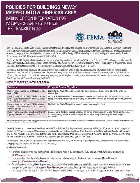
22 Newly Mapped Into SFHA Following a map revision, a building newly mapped into an SFHA can be rated as a Newly Mapped Policy. This rate will be equal to the PRP rate for the first 12 months of the policy After the first year of the Newly Mapped policy, the rate will begin its transition to a full-risk rate with annual rate increases of no more than 18 percent each year. 21
23 Newly Mapped Procedure 11/11/2016 Map Effective Date 11/10/ mos. after Map Effective Date 2016 Standard Zone X = $2, Zone X PRP Policy $441* 1/1/11 Zone AE Newly Mapped Property (PRP Rate*) $490 Newly Mapped Property Rate** $565 Newly Mapped Property Rate** $650 11/09/2016 New Policy Effective Date 11/09/2017 Renewal Date 11/09/2018 Renewal Date 11/09/2019 Renewal Date $200K/$80K Building/Contents April 2016; excludes HFIAA Surcharge *Current PRP Rates (assumes 3 % increase) plus higher RFA and FPF) **Guesstimates Actual planned rate increases unknown Bender Consulting Services, Inc. 22

24 Grandfathering BFE or Zone When flood map changes occur, a lower-cost rating option known as grandfathering is available. It is available for property owners who: Already have flood insurance policies in effect when the new flood maps become effective and then maintain Continuous Coverage; or Have Built in Compliance with the FIRM in effect at the time of construction. Grandfather the best PREMIUM, not the best ZONE e.g. AE +3 may be lower premium than PRP or STD X 23
25 Mapped Out of SFHA Cancel/Rewrite Reason 24 to PRP (Conversion) Cancel/Rewrite Due to Map Revision, LOMA, or LOMR (Page CN 9 of FIM): Used to cancel and rewrite a standard-rated policy to a PRP as the result of a map revision, LOMA, or LOMR. The standard-rated policy will be canceled and rewritten as a PRP. Premium from the canceled policy will be applied to the PRP, with the difference refunded to the policyholder. The agent/producer will retain the full commission on both policies, and the company s expense allowance will not be reduced. 24
, and send a new declarations page and refund to the")
26 Mapped Out of SFHA Proactively change to PRP as soon as map changes to try to retain the business. At WYO direction, we will endorse to PRP (if eligible), and send a new declarations page and refund to the insured. 25
")

27 Multi-Rating Comparatively rating against all possible/eligible/valid rating methods or paths Determine total premium based on new zone / BFE; then check: Grandfathering Newly Mapped PRP Conversion Pre-FIRM Subsidized Pre-FIRM Actuarial (EC-Rated) Prior SFHA with EC rates may be better than current B,C,X STD rates. Annual premium may be lower by grandfathering the SFHA with an EC. Rating with lowest total annual premium that the insured is eligible for provides the best customer experience. 26

28 ive OUTREACH & MESSAGING BRUCE A. BENDER, 27 CFM


29 AGENT/WYO ENGAGEMENT Connect with community officials early. When released, note where changes occur. Critical time to reach out to clients; get ahead of the media. Great opportunity to reach out to prospects. 28

30 AGENT/WYO ENGAGEMENT OPEN HOUSE Public can view maps; ask local officials questions. Encourage clients and prospects to attend. Typical questions to prepare for: How am I affected? If newly mapped in: How do I get out of it? What s the cheapest cost for flood insurance? So Know Your Rating Options 29

31 AGENT/WYO ENGAGEMENT Final opportunity to reach out before effective date. Review existing residential and commercial clients to see how they are affected. Even if not affected, are they properly covered? Great prospecting opportunity as well. 30
32 MESSAGING Newly Mapped into High-Risk Area The area your building is in has been newly identified as a high-risk area for flooding. Most lenders require flood insurance in these areas. If you don t carry a mortgage, you should still protect your investment with flood insurance. National statistics show that you are more likely to experience a flood than a fire. The NFIP offers options to help you save on flood insurance. Purchase and have a PRP in effect before the new maps become effective to maximize your savings and reduce your financial risk now. 31


33 MESSAGING High-risk to Higher-Risk (BFE or Zone) Your building is now at an even higher risk of flooding. Rates are higher for higher-risk areas. Purchasing a policy before the map revision allows you to lock in the lower-risk zone or BFE for future rating, and therefore save on insurance. Renew the policy each year to stay financially protected and save money. In high-risk areas, there is at least a 1 in 4 chance of flooding over the life of a 30-year loan and a greater chance of a flood than a fire. 32
34 MESSAGING High-risk to Moderate-Low Risk Your risk is reduced, not removed. People in moderate- and low-risk areas file more than 20% of all NFIP flood insurance claims and receive one third of flood disaster assistance. You may be eligible for a lower-cost PRP, which includes contents. Stay financially protected and get money back once the map is effective. There will be no gaps in coverage and no additional money up front. 33
35 MESSAGING No Change in BFE or Zone Still at risk; understand your level of risk If currently has flood insurance: Is it at current replacement cost? Are the contents fully covered? If not currently covered for flood: Do they qualify for a PRP? If they don t want coverage, have them decline in writing! 34

36 RESOURCES 35
37 FLOODSMART.GOV 36

38 Agents.FloodSmart.gov 37


39 Agents.FloodSmart.gov FloodSmart Resources for Agents Newly Mapped Procedure Fact Sheet Flood Map Change Tips Fact Sheet Grandfather Fact Sheet PRP Conversion Fact Sheet Flood Insurance Waiver Template Direct Mail Postcard Template Direct Mail Letter Template FEMA Resources for Agents NFIP Training Modules 38


40 Agents.FloodSmart.gov + Risk MAP Risk MAP Depth Grid 39


41 Other Resources MSC.FEMA.gov 40
42 Other Resources

43 QUESTIONS? I know, but calling it Grandmothering just doesn t have the same effect! 42
Agenda. Introduction. Introduction -Map Study Lifecycle. Insurance Benefits of New Map
 Agenda Introduction Effects of Map Changes on Flood Insurance Lower risk to higher risk ( Grandfathering ) Higher risk to lower risk ( Conversion ) No Change Vertical Datum change Summary Levees Levees
De-Mystifying Grandfathering (and Other Flood Insurance Options) -What Floodplain Managers Should Know When Maps Change-
 -What Floodplain Managers Should Know When Maps Change-") De-Mystifying Grandfathering (and Other Flood Options) -What Floodplain Managers Should Know When Maps Change- ASFPM 2009 Annual Conference Orlando, FL June 11, 2009 Bruce A. Bender Services, Inc. Agenda
De-Mystifying Grandfathering (and Other Flood Options) -What Floodplain Managers Should Know When Maps Change- ASFPM 2009 Annual Conference Orlando, FL June 11, 2009 Bruce A. Bender Services, Inc. Agenda
Impacts of Map Changes -Flood Insurance-
 Impacts of Map Changes -Flood Insurance- 1 Effective Dates Waiting Periods 30-day 1-day 0 day 2 Flood Zones Moderate- and Low-Risk B, C, X, Shaded X Over 35% of Arizona flood claims occur here High-Risk
National Flood Insurance Program 3. FEMA All rights reserved
 National Flood Insurance Program 3 Poll Question 1 A very upset property owner comes to you with a letter from the Bank. The letter states he has now been moved into a high risk zone and Flood Insurance
YAVAPAI COUNTY FLOOD CONTROL DISTRICT STAKEHOLDER WORKSHOP. March 30 th & 31 st, 2015
 YAVAPAI COUNTY FLOOD CONTROL DISTRICT STAKEHOLDER WORKSHOP March 30 th & 31 st, 2015 1 Floods Happen In Yavapai County September 1983 Northwest Prescott Area: - Willow Creek - Bottleneck Wash - Granite
National Flood Insurance Program (NFIP) Biggert-Waters Act 2012 (BW12)
 Biggert-Waters Act 2012 (BW12)") National Flood Insurance Program (NFIP) Biggert-Waters Act 2012 (BW12) NFIP Re-Authorization & Reform Todd Bass Natural Hazards Program Specialist Floodplain Management and Insurance Branch Mitigation
National Flood Insurance Program (NFIP) Biggert-Waters Act 2012 (BW12) NFIP Re-Authorization & Reform Todd Bass Natural Hazards Program Specialist Floodplain Management and Insurance Branch Mitigation
National Flood Insurance Program Changes Effective April 1, 2016
 National Flood Insurance Program Changes Effective April 1, 2016 Beginning April 1, 2016, the National Flood Insurance Program (NFIP) will begin implementing additional flood insurance program changes
F E M A Mapping Changes. FEMA Mapping Changes. National Flood Insurance Program
 FEMA Mapping Changes National Flood Insurance Program 1 Welcome to FEMA Mapping Changes! We will get started in a few minutes. Meanwhile, let s perform a warm up exercise. 2 1 Training Agenda Section 1-
Kevin Wagner Maryland Department of the Environment
 Kevin Wagner Maryland Department of the Environment Topics Overview of the National Flood Insurance Program (NFIP) Mapping Regulations Insurance Mitigation Community Rating System (CRS) Questions Know
National Flood Insurance Program BW-12
 National Flood Insurance Program BW-12 Janice Mitchell, Insurance Specialist, Floodplain Management and Insurance Branch FEMA, Region 4 Janice.mitchell@fema.dhs.gov Biggert-Waters 2012 - What Everyone
NFIP Overview and Legislative Changes. North Carolina Emergency Management
 NFIP Overview and Legislative Changes Reauthorization Extended to July 31, 2018 Congress to consider reforms Who Writes Flood Insurance? State Licensed Insurance Agents: Can write property and casualty
Changes to the National Flood Insurance Program What to Expect
 Changes to the National Flood Insurance Program What to Expect Impact of changes to the NFIP under Homeowner Flood Insurance Affordability Act of 2014 More Changes are Coming to the NFIP On March 21, 2014,
October 1, Write Your Own (WYO) Principal Coordinators and the National Flood Insurance Program (NFIP) Servicing Agent
 Principal Coordinators and the National Flood Insurance Program (NFIP) Servicing Agent") U.S. Department of Homeland Security Washington, D.C. 20472 October 1, 2015 MEMORANDUM FOR: Write Your Own (WYO) Principal Coordinators and the National Flood Insurance Program (NFIP) Servicing Agent FROM:
U.S. Department of Homeland Security Washington, D.C. 20472 October 1, 2015 MEMORANDUM FOR: Write Your Own (WYO) Principal Coordinators and the National Flood Insurance Program (NFIP) Servicing Agent FROM:
Changes to the National Flood Insurance Program What to Expect
 Changes to the National Flood Insurance Program What to Expect Impact of changes to the NFIP under Homeowner Flood Insurance Affordability Act of 2014 BW-12: What Changed Subsidies to be phased out Non-primary
Durham County Preliminary Flood Hazard Data Public Meeting. July 28, 2016
 Durham County Preliminary Flood Hazard Data Public Meeting July 28, 2016 Why Are We Here New flood hazard data has been released as Preliminary for Durham County Statutory Due Process for review/comments
Abington Township Public Meeting
 Abington Township Public Meeting Flood Insurance Rate Map Update March 23, 2016 1 Meeting Agenda and Format Provide residents/property owners of Abington Township with information about the map update,
CANCELLATION/NULLIFICATION
 Previous Section Main Menu Table of Contents Next Section Fld insurance coverage may be terminated by either canceling or nullifying the policy, only in accordance with a valid reason for the transaction,
BIGGERT-WATERS 2012 TALKING POINTS
 BIGGERT-WATERS 2012 TALKING POINTS No Extension of Subsidy on the Pre-FIRM Properties in SFHA s & Zone D Effective October 1, 2013, the NFIP will no longer provide any extension of premium rate subsidy
ATTACHMENT A UNDERWRITING GUIDELINES OCTOBER 1, 2014 REFUND PROCEDURES
 ATTACHMENT A UNDERWRITING GUIDELINES OCTOBER 1, 2014 REFUND PROCEDURES Underwriting Guidelines for HFIAA Section 3 and Section 5 Refund Procedures Background Section 3 of HFIAA requires FEMA to restore
Changes Coming to the National Flood Insurance Program What to Expect. Impact of changes to the NFIP under Section 205 of the Biggert-Waters Act
 Changes Coming to the National Flood Insurance Program What to Expect Impact of changes to the NFIP under Section 205 of the Biggert-Waters Act Flood Risk Flood risks and the costs of flooding Weather
GENERAL CHANGE ENDORSEMENT
 Previous Section Main Menu Table of Contents Next Section GENERAL CHANGE ENDORSEMENT The National Flood Insurance Program (NFIP) General Change Endorsement form cannot be used to renew a policy, or extend
Preliminary DFIRM Community Coordination (PDCC) Meeting Gilchrist & Levy Counties, FL. April 30, 2015
 Meeting Gilchrist & Levy Counties, FL. April 30, 2015") Preliminary DFIRM Community Coordination (PDCC) Meeting Gilchrist & Levy Counties, FL April 30, 2015 Agenda 1. Introductions 2. Study Process and Timeline 3. Overview of Preliminary Products 4. Overview
Preliminary DFIRM Community Coordination (PDCC) Meeting Gilchrist & Levy Counties, FL April 30, 2015 Agenda 1. Introductions 2. Study Process and Timeline 3. Overview of Preliminary Products 4. Overview
National Flood Insurance Program, Biggert-Waters 2012, and Homeowners Flood Insurance Affordability Act 2014
 National Flood Insurance Program, Biggert-Waters 2012, and Homeowners Flood Insurance Affordability Act 2014 Janice Mitchell, Insurance Specialist Floodplain Management and Insurance Branch FEMA Region
cost of the building. (See Example 4 at the end of this section.)
") . The National Flood Insurance Program (NFIP) General Change Endorsement form or a similar request can be used to make certain types of coverage and rating changes or corrections to the existing policy.
. The National Flood Insurance Program (NFIP) General Change Endorsement form or a similar request can be used to make certain types of coverage and rating changes or corrections to the existing policy.
11/18/2011. FEMA All rights reserved. FEMA All rights reserved. Session Overview
 3 Session Overview 4 1 Welcome to Session 2 of the FEMA NFIP Agent Training Program! Dorothy Martinez Rich Slevin Recall your learning from the previous session and share at least one important takeaway.
Key Fundamentals of Flood Insurance
 a Welcome to Key Fundamentals of Flood Insurance An entry-level approach for real estate professionals [Photo credit: Oliver Gruener] We will get started in a few minutes. Presented Meanwhile, by: let
REAL ESTATE FLOOD DISCLOSURE PROGRAM & FLOOD MAP INFORMATION SERVICES
 REAL ESTATE FLOOD DISCLOSURE PROGRAM & FLOOD MAP INFORMATION SERVICES Agenda 10:30-12:00 Flood Disclosure Program 12:00-12:30 Lunch 12:30-1:30 Flood Map Service Center Lisa Foster, CFM, Floodplain Coordinator
Federal Emergency Management Agency
 Page 1 of 3 COMMUNITY AND MAP PANEL INFORMATION COMMUNITY CITY OF MARGATE CITY, ATLANTIC COUNTY, NEW JERSEY LEGAL PROPERTY DESCRIPTION A parcel of land, as described in Deed recorded in Book 4826, page
1. Will policies that need to be cancelled and rewritten be done so under cancellation reason number 24? If not how do we handle agency commissions?
 Part II: Technical Questions and Answers Regarding the Extension of Preferred Risk Policy Eligibility Effective October 1, 2010, After Flood Insurance Rate Map Changes Effective On or After October 1,
Door County Floodplain Program Informational Meeting
 Door County Floodplain Program Informational Meeting Door County Land Use Services Department Wisconsin Department of Natural Resources January 15, 2018 Floodplain = Land affected by flood event with a
History of Floodplain Management in Ascension Parish
 History of Floodplain Management in Ascension Parish presented by: Kara Moree Floodplain Coordinator February 6, 2012 Floodplain 101 Floodplain 101 Base or 1% Flood: A flood having a 1% chance of being
National Flood Insurance Program and Biggert-Waters 2012
 National Flood Insurance Program and Biggert-Waters 2012 National Flood Insurance Program NFIP was created by Congress in 1968 Coverage underwritten by the Federal Government, administered by FEMA NFIP
May 16th, FEMA Region I. MA Agents Association Live-Stream on May 16, 2017 AGENDA
 May 16th, 2017 FEMA Region I MA Agents Association Live-Stream on May 16, 2017 AGENDA 1. April 1, 2017 Changes 2. October 2017 Changes 3. Section 28 Clear Communications 4. Private Flood Insurance 5. Misc.
June 26, Write Your Own (WYO) Principal Coordinators and the National Flood Insurance Program (NFIP) Direct Servicing Agent (DSA)
 Principal Coordinators and the National Flood Insurance Program (NFIP) Direct Servicing Agent (DSA)") June 26, 2014 MEMORANDUM FOR: FROM: SUBJECT: Write Your Own (WYO) Principal Coordinators and the National Flood Insurance Program (NFIP) Direct Servicing Agent (DSA) David L. Miller Associate Administrator
June 26, 2014 MEMORANDUM FOR: FROM: SUBJECT: Write Your Own (WYO) Principal Coordinators and the National Flood Insurance Program (NFIP) Direct Servicing Agent (DSA) David L. Miller Associate Administrator
National Flood Insurance Program Making Sense of April 2019 Changes
 National Flood Insurance Program Making Sense of April 2019 Changes Foreword The National Flood Insurance Program (NFIP) provides an important means for property owners to protect themselves financially
Presented by: Brian T. Ford, CPCU, MBA of Insurance Resources and Ashley Tharp of Wright Flood
 Presented by: Brian T. Ford, CPCU, MBA of Insurance Resources and Ashley Tharp of Wright Flood National Flood Insurance Program 1/28/69 Goals Prevent future loss of life & property Reduce public monies
NFIP: October 2016 Updates and Community Decision Impacts on Individual Rates
 NFIP: October 2016 Updates and Community Decision Impacts on Individual Rates Carl Watts, Regional Liaison NFIP-iService, Region VI cwatts@nfip-iservice.com P: 405-257-9000 1 1 NFIP: Review and October
Using GISWeb to Determine Your Property s Flood Zone
 Using GISWeb to Determine Your Property s Flood Zone 1. In a new browser window, go to http://www.co.santacruz.ca.us/departments/geographicinformationsystemsgis.aspx 2. Click on GISWeb - GIS Mapping Application
Cameron County, TX. Consultation Coordination Officer (CCO) Meeting. Please sign in (sheet at front of the room) Meeting will begin at 9:00
 Meeting. Please sign in (sheet at front of the room) Meeting will begin at 9:00") Cameron County, TX Consultation Coordination Officer (CCO) Meeting Please sign in (sheet at front of the room) Meeting will begin at 9:00 July 29, 2015 Lisa Jennings FEMA Region 6 Roles & Responsibilities
Cameron County, TX Consultation Coordination Officer (CCO) Meeting Please sign in (sheet at front of the room) Meeting will begin at 9:00 July 29, 2015 Lisa Jennings FEMA Region 6 Roles & Responsibilities
National Flood Insurance Program
 National Flood Insurance Program A Discussion in Three Parts: The Nature of Flood Risk An Overview of the NFIP Impact of Recent Legislation (BW-12 & HFIAA-14) Nature of Flood Risk FLOODS ARE AN ACT OF
Changes to the National Flood Insurance Program: From Biggert to Grimm Waters. Click to edit Master title style. Click to edit Master subtitle style
 Changes to the National Flood Insurance Program: Click to edit Master title style From Biggert to Grimm Waters Click to edit Master subtitle style Thomas Ruppert Coastal Planning Specialist With thanks
NFIP Program Basics. KAMM Regional Training
 NFIP Program Basics KAMM Regional Training Floodplain 101 Homeowners insurance does not cover flood damage Approximately 25,000 flood insurance policies in KY According to BW12 analysis, approximately
ATTACHMENT A SUMMARY OF THE NFIP OCTOBER 2013 PREMIUM RATE AND RULE CHANGES
 ATTACHMENT A SUMMARY OF THE NFIP OCTOBER 2013 PREMIUM RATE AND RULE CHANGES National Flood Insurance Program October 1, 2013, Premium Rate and Rule Changes: A Summary 1. Premium Increases Premiums will
May 5, Write Your Own (WYO) Principal Coordinators and the National Flood Insurance Program (NFIP) Servicing Agent
 Principal Coordinators and the National Flood Insurance Program (NFIP) Servicing Agent") U.S. Department of Homeland Security 500 C Street, SW Washington, DC 20472 W-13026 May 5, 2013 MEMORANDUM FOR: Write Your Own (WYO) Principal Coordinators and the National Flood Insurance Program (NFIP)
U.S. Department of Homeland Security 500 C Street, SW Washington, DC 20472 W-13026 May 5, 2013 MEMORANDUM FOR: Write Your Own (WYO) Principal Coordinators and the National Flood Insurance Program (NFIP)
Updates to Maine Coastal Flood Insurance Rate Maps (FIRM s): What a Local Official Should Know. Presented by: Steve Johnson, P.E.
: What a Local Official Should Know. Presented by: Steve Johnson, P.E.") Updates to Maine Coastal Flood Insurance Rate Maps (FIRM s): What a Local Official Should Know Presented by: Steve Johnson, P.E. Town Engineer October 4, 2018 Introduction Federal Emergency Management
Updates to Maine Coastal Flood Insurance Rate Maps (FIRM s): What a Local Official Should Know Presented by: Steve Johnson, P.E. Town Engineer October 4, 2018 Introduction Federal Emergency Management
REAL ESTATE FLOOD DISCLOSURE PROGRAM & FLOOD MAP INFORMATION SERVICES
 REAL ESTATE FLOOD DISCLOSURE PROGRAM & FLOOD MAP INFORMATION SERVICES Lisa Foster, CFM, Floodplain Coordinator ldfoster@pinellascounty.org January 26, 2018 Why are you here? Save your clients money on
210 W Canal Dr Palm Harbor, FL 34684
 Flood Analysis Memo Property Address In Partnership with: ** This property is within a high risk flood zone ** BFE = 6 ft This property is located in the FEMA designated high-risk zone, Zone AE - an area
VFMA Workshop October 16, David M. Gunn, P.E., CFM Henrico County DPW
 VFMA Workshop October 16, 2014 David M. Gunn, P.E., CFM Henrico County DPW Agenda NFIP Virginia Statistics BW-12 GW-14 Community Actions Flood Damages are not the result of a Natural Disaster, They are
National Flood Insurance Program. Jennifer Gilbert, CFM, ANFI New Hampshire NFIP State Coordinator
 National Flood Insurance Program Jennifer Gilbert, CFM, ANFI New Hampshire NFIP State Coordinator What is the National Flood Insurance Program? Created by Congress in 1968 Participating Communities voluntarily
10526 Bermuda Isle Dr. Tampa, FL 33647
 Flood Analysis Memo Property Address In Partnership with: ** This property is NOT within a high-risk flood zone ** This property is located in a FEMA low-risk zone designated as Zone X - an area of minimal
Floodplain Management 101. Mississippi Emergency Management Agency Floodplain Management Bureau
 Floodplain Management 101 Mississippi Emergency Management Agency Floodplain Management Bureau Stafford Act The Stafford Disaster Relief and Emergency Assistance Act (Stafford Act) (Public Law 100-707)
The National Flood Insurance Program and Flood Insurance Rate Map for San Francisco. Presentation at Treasure Island Community Meeting
 The National Flood Insurance Program and Flood Insurance Rate Map for San Francisco Presentation at Treasure Island Community Meeting October 17, 2007 1 National Flood Insurance Program (NFIP) Overview
Introduction to the National Flood Insurance Program: A Guide for Coastal Property Owners MAINE BEACHES CONFERENCE 2017
 Introduction to the National Flood Insurance Program: A Guide for Coastal Property Owners MAINE BEACHES CONFERENCE 2017 SUE BAKER, CFM STATE NFIP COORDINATOR MAINE DEPT OF AGRICULTURE, CONSERVATION & FORESTRY
On March 21, 2014, President Obama signed the Homeowner Flood Insurance Affordability Act of 2014 into law.
 On March 21, 2014, President Obama signed the Homeowner Flood Insurance Affordability Act of 2014 into law. This law repeals and modifies certain provisions of the Biggert-Waters Flood Insurance Reform
Floodplain Manager s Toolkit Unlocking the Hidden Potential of Floodplain Data for Your Community
 Floodplain Manager s Toolkit Unlocking the Hidden Potential of Floodplain Data for Your Community TFMA South Central Lunch Event San Antonio, TX June 12, 2014 Jessica D. Baker, PE, CFM, PMP Samuel Amoako-Atta,
Changes to the National Flood Insurance Program: From Biggert-Waters. to Grimm-Waters. Click to edit Master title style
 Changes to the National Flood Insurance Program: From Biggert-Waters Click to edit Master title style to Grimm-Waters Click to edit Master subtitle style Thomas Ruppert Coastal Planning Specialist Florida
PREFERRED RISK POLICY
 Previous Section Main Menu Table of Contents Next Section PREFERRED RISK POLICY I. GENERAL DESCRIPTION The Preferred Risk Policy (PRP) is a lower-cost Standard Fld Insurance Policy (SFIP), written under
If you have any questions or concerns please give us a call at , or Walter Jenkins at (ext 300).
.") FLORIDA FLOODZONE SERVICES Flood Insurance and Zone Consulting 461 SE 3 rd Terrace Pompano Beach, FL 33060 Phone 954-290-7420 bspencer@florida-floodzone.com March 15, 2010 Dear Portofino Lakes Homeowner:
FLORIDA FLOODZONE SERVICES Flood Insurance and Zone Consulting 461 SE 3 rd Terrace Pompano Beach, FL 33060 Phone 954-290-7420 bspencer@florida-floodzone.com March 15, 2010 Dear Portofino Lakes Homeowner:
ATTACHMENT A SUMMARY OF THE NFIP PROGRAM CHANGES EFFECTIVE APRIL 1, 2018 AND JANUARY 1, 2019
 ATTACHMENT A SUMMARY OF THE NFIP PROGRAM CHANGES EFFECTIVE APRIL 1, 2018 AND JANUARY 1, 2019 National Flood Insurance Program April 1, 2018 and January 1, 2019 Program Changes: A Summary The changes outlined
Flood Hazard Risk Mapping:
 Mitigation Division Flood Hazard Risk Mapping: Past, Present and Future Oklahoma Floodplain Management Association Ron Wanhanen, PE FEMA Region 6 Risk Analysis Branch Overview The Past The Present Risk
10526 Bermuda Isle Dr. Tampa, FL 33647
 Flood Analysis Memo Property Address 10526 Bermuda Isle Dr. In Partnership with: ** This property is NOT within a high-risk flood zone ** 10526 Bermuda Isle Dr. BFE = 35 ft This property is located in
Skagit County Flood Insurance Study Update. Ryan Ike, CFM FEMA Region 10
 Skagit County Flood Insurance Study Update Ryan Ike, CFM FEMA Region 10 Skagit County Flood Insurance Study Process Overview Process, Schedule, & Deliverables Base Flood Elevations, Modeling, & Levees
Kentucky Risk MAP It s not Map Mod II
 Kentucky Risk MAP It s not Map Mod II Risk Mapping Assessment and Planning Carey Johnson Kentucky Division of Water carey.johnson@ky.gov What is Risk MAP? Risk Mapping, Assessment, and Planning (Risk MAP)
TOP 10 Flood Insurance Changes
 TOP 10 Flood Insurance Changes What Every Floodplain Official Should Know Rich Slevin, H 2 O Partners Dorothy Martinez, H 2 O Partners 1 TOP 10 Flood Insurance Changes What Every Floodplain Official Should
W October 1, Write Your Own (WYO) Principal Coordinators and the National Flood Insurance Program (NFIP) Servicing Agent
 Principal Coordinators and the National Flood Insurance Program (NFIP) Servicing Agent") U.S. Department of Homeland Security 500 C St. SW Washington, D.C. 20472 W-14053 October 1, 2014 MEMORANDUM FOR: Write Your Own (WYO) Principal Coordinators and the National Flood Insurance Program (NFIP)
U.S. Department of Homeland Security 500 C St. SW Washington, D.C. 20472 W-14053 October 1, 2014 MEMORANDUM FOR: Write Your Own (WYO) Principal Coordinators and the National Flood Insurance Program (NFIP)
Flood Analysis Memo. 629 Orangewood Dr. Dunedin, FL BFE = 21 ft
 Flood Analysis Memo Property Address 629 Orangewood Dr. In Partnership with: ** This property is NOT within a high-risk flood zone ** 629 Orangewood Dr. BFE = 21 ft This property is located in the FEMA
Many of the changes to the NFIP were recently revised on March 21, 2014 by the Homeowner Flood Insurance Affordability Act of 2014.
 F l oodawa r e ne swe e k Ma r c h19-ma r c h25 2017 Below is a summary of the topics we will discuss today. On July 6, 2012, the Biggert-Waters Flood Insurance Reform Act of 2012 was passed by Congress
Biggert-Waters The Changing Script
 Biggert-Waters 2012 The Changing Script Policyholder Subsidies These policies are not Pre-FIRM subsidized (already actuarially rated), 4,480,669 policies. They are not affected by 205 but may see routine
REAL ESTATE FLOOD DISCLOSURE PROGRAM & FLOOD MAP INFORMATION SERVICES
 REAL ESTATE FLOOD DISCLOSURE PROGRAM & FLOOD MAP INFORMATION SERVICES Lisa Foster, CFM, Floodplain Coordinator ldfoster@pinellascounty.org January 26, 2018 Why are you here? Save your clients money on
Gail Moldovan-Trujillo, ACSR,CPIW Hagan Hamilton Insurance 2012 NFIP Agency of the year Flood Insurance Specialist & Consultant
 Gail Moldovan-Trujillo, ACSR,CPIW Hagan Hamilton Insurance 2012 NFIP Agency of the year Flood Insurance Specialist & Consultant Flood Insurance regulations continue to change at a very rapid pace, therefore
Duval County, Florida Consultation Coordination Officer (CCO) Meeting. January 25, 2017 Jacksonville, Florida
 Meeting. January 25, 2017 Jacksonville, Florida") Duval County, Florida Consultation Coordination Officer (CCO) Meeting January 25, 2017 Jacksonville, Florida Agenda Introductions Coastal Study Update Study Process and Timeline Flood Insurance Implications
Duval County, Florida Consultation Coordination Officer (CCO) Meeting January 25, 2017 Jacksonville, Florida Agenda Introductions Coastal Study Update Study Process and Timeline Flood Insurance Implications
National Flood Insurance Program (NFIP) for Real Estate Professionals
 for Real Estate Professionals") National Flood Insurance Program (NFIP) for Real Estate Professionals 1 Joshua Oyer, CFM Outreach Specialist NFIP State Coordinator s Office at the Texas Water Development Board 2 Outline Introduction
National Flood Insurance Program (NFIP) for Real Estate Professionals 1 Joshua Oyer, CFM Outreach Specialist NFIP State Coordinator s Office at the Texas Water Development Board 2 Outline Introduction
Floodplain Management 101: UNIT II. Maps & Flood Insurance Studies
 Floodplain Management 101: UNIT II Maps & Flood Insurance Studies Who is ASFPM? ASFPM stands for the Association of State Floodplain Managers A national organization of floodplain management professionals
Bullitt County, Kentucky Preliminary DFIRM Community Open House. October 8, 2014 Shepherdsville, Kentucky
 Bullitt County, Kentucky Preliminary DFIRM Community Open House October 8, 2014 Shepherdsville, Kentucky Meeting Agenda Introductions Overview of Preliminary DFIRMs Overview of Map Appeal Process Questions
Pinellas County Flood Map Information Service & Real Estate Disclosure Program Training January 26, 2017 COMMON FLOODPLAIN ACRONYMS
 FEMA ASFPM BFE CAV Pinellas County Flood Map Information Service & Real Estate Disclosure Program Training COMMON FLOODPLAIN ACRONYMS Federal Emergency Management Agency Association of State Floodplain
Using Non-Regulatory RiskMAP Products in Floodplain Management. Ferrin Affleck, PE, CFM, Water Resources Engineer Project Manager Atkins
 Using Non-Regulatory RiskMAP Products in Floodplain Management Ferrin Affleck, PE, CFM, Water Resources Engineer Project Manager Atkins 1 Goal of this Presentation Inform Peak interest Stimulate creativity
How Does Flood Insurance Work?
 How Does Flood Insurance Work? The National Flood Insurance Program (NFIP) Makes Available: flood insurance disaster assistance grants and loans In Exchange For: Local adoption of a floodplain ordinance
Flood Risk Review (FRR) Meeting. Cumberland County, Pennsylvania Carlisle, Pennsylvania December 5, 2016
 Meeting. Cumberland County, Pennsylvania Carlisle, Pennsylvania December 5, 2016") Flood Risk Review (FRR) Meeting Cumberland County, Pennsylvania Carlisle, Pennsylvania December 5, 2016 Why are we here today? The Flood Insurance Study (FIS) report and Flood Insurance Rate Maps (FIRMs)
Flood Risk Review (FRR) Meeting Cumberland County, Pennsylvania Carlisle, Pennsylvania December 5, 2016 Why are we here today? The Flood Insurance Study (FIS) report and Flood Insurance Rate Maps (FIRMs)
May 1, Write Your Own (WYO) Principal Coordinators and the National Flood Insurance Program (NFIP) Servicing Agent
 Principal Coordinators and the National Flood Insurance Program (NFIP) Servicing Agent") U.S. Department of Homeland Security 500 C St. SW Washington, D.C. 20472 W-15016 May 1, 2015 MEMORANDUM FOR: Write Your Own (WYO) Principal Coordinators and the National Flood Insurance Program (NFIP)
U.S. Department of Homeland Security 500 C St. SW Washington, D.C. 20472 W-15016 May 1, 2015 MEMORANDUM FOR: Write Your Own (WYO) Principal Coordinators and the National Flood Insurance Program (NFIP)
JAXGIS FEMA Flood Hazard Mapping -- Frequently Asked Questions
 Flood Hazard Zone Designations Summary Zones starting with the letter 'A' (for instance, Zone A, Zone AE, Zone AH, Zone AO) denote a Special Flood Hazard Area, which can also be thought of as the 100-year
Nassau County, Florida Consultation Coordination Officer (CCO) Meeting. February 24, 2016 Fernandina Beach, Florida
 Meeting. February 24, 2016 Fernandina Beach, Florida") Nassau County, Florida Consultation Coordination Officer (CCO) Meeting February 24, 2016 Fernandina Beach, Florida Agenda Introductions Coastal Study Update Study Process and Timeline Flood Insurance Implications
Nassau County, Florida Consultation Coordination Officer (CCO) Meeting February 24, 2016 Fernandina Beach, Florida Agenda Introductions Coastal Study Update Study Process and Timeline Flood Insurance Implications
National Flood Insurance Program Making Sense of. April 2018 Changes. April
 National Flood Insurance Program Making Sense of April 2018 Changes April 2018 Introduction Table of Contents As you may know, the National Flood Insurance Program (NFIP) implements program changes biannually.
April 2, Write Your Own Principal Coordinators and the NFIP Servicing Agent
 U.S. Department of Homeland Security 500 C Street, SW Washington, DC 20472 W-09021 April 2, 2009 MEMORANDUM TO: Write Your Own Principal Coordinators and the NFIP Servicing Agent FROM: SUBJECT: Edward
Georgia Flood M.A.P. Program Risk MAP Plenary Session GAFM 2011
 Georgia Flood M.A.P. Program Risk MAP Plenary Session GAFM 2011 Collis Brown, Georgia DNR March 24, 2011 GA Flood Map Modernization Responsible for end-to-end production Developed aggressive outreach program
Taylor County, Florida Community Coordination and Outreach (CCO) Meeting
 Meeting") Taylor County, Florida Community Coordination and Outreach (CCO) Meeting Suwannee River Water Management District April 26, 2017 11:00AM to 12:00PM Taylor County Administration Building, 201 E. Green Street,
Taylor County, Florida Community Coordination and Outreach (CCO) Meeting Suwannee River Water Management District April 26, 2017 11:00AM to 12:00PM Taylor County Administration Building, 201 E. Green Street,
Requirements for Construction on Properties in the Special Flood Hazard Area (SFHA)
") Requirements for Construction on Properties in the Special Flood Hazard Area (SFHA) Rev 010915 The website for the IDNR to request the EFARA (Electronic Floodplain Analysis/Regulatory Assessment is found
Requirements for Construction on Properties in the Special Flood Hazard Area (SFHA) Rev 010915 The website for the IDNR to request the EFARA (Electronic Floodplain Analysis/Regulatory Assessment is found
COMMUNICATING FLOOD RISK AT THE LOCAL LEVEL
 COMMUNICATING FLOOD RISK AT THE LOCAL LEVEL BRUCE A. BENDER BENDER CONSULTING SERVICES, INC. NOVEMBER 12-13, 2008 COMMUNICATING FLOOD RISK AT THE LOCAL LEVEL AGENDA A Look at Risk Communicating Risk Planning
City of Pensacola and Escambia County Flood Risk and Flood Insurance Study
 City of Pensacola and Escambia County Flood Risk and Flood Insurance Study Preliminary Report 1: Long Hollow and Sanders Beach Tracts Wharton Risk Management and Decision Processes Center November 8, 2016
AGENDA. Floodplain Manager s Toolkit Unlocking the Hidden Potential of Floodplain Data for Your Community
 Floodplain Manager s Toolkit Unlocking the Hidden Potential of Floodplain Data for Your Community TFMA Spring Conference May 29, 2014 Jessica D. Baker, PE, CFM, PMP Samuel Amoako-Atta, GISP, CFM Eric Hajek,
Questions about the National Flood Insurance Program
 Questions about the National Flood Insurance Program Federal Emergency Management Agency (FEMA) Questions and Answers What is the National Flood Insurance Program (NFIP)? The NFIP is a Federal program
THE FEDERAL EMERGENCY MANAGEMENT AGENCY. Letters of Map Change Kristen Martinenza, P.E., CFM FEMA Region IV
 THE FEDERAL EMERGENCY MANAGEMENT AGENCY Letters of Map Change Presented by: Kristen Martinenza, P.E., CFM FEMA Region IV 1 NATIONAL FLOOD INSURANCE ACT OF 1968 At the start of the program, there was not
Introduction to Lender Compliance. National Flood Insurance Program
 Introduction to Lender Compliance National Flood Insurance Program 1 Welcome to Introduction to Lender Compliance! We will get started in a few minutes. Meanwhile, let s perform a warm up exercise. 2 1
CONDOMINIUMS I. METHODS OF INSURING CONDOMINIUMS. Important Notice to Agents/Producers:
 Previous Section Main Menu Table of Contents Next Section Important Notice to Agents/Producers: CONDOMINIUMS Boards of directors of condominium associations typically are responsible under their by-laws
National Flood Insurance Program
 National Flood Insurance Program FEMA ELEVATION CERTIFICATES PA Surveyor Training Presented by Thomas F. Smith, PE, PLS January 22, 2018 1 FEMA Region III Mitigation Division Floodplain Management & Insurance
Consultation Coordination Officer (CCO) Meeting
 Meeting") Consultation Coordination Officer (CCO) Meeting Middle Brazos Lake Whitney Physical Map Revision Hill and McLennan Counties FEMA Region 6 Agenda National Flood Insurance Program Purpose of the Meeting
Consultation Coordination Officer (CCO) Meeting Middle Brazos Lake Whitney Physical Map Revision Hill and McLennan Counties FEMA Region 6 Agenda National Flood Insurance Program Purpose of the Meeting
SPECIAL CERTIFICATIONS
 SPECIAL CERTIFICATIONS This section presents detailed instructions for the completion of the National Flood Insurance Program (NFIP) Elevation Certificate (EC) and the NFIP Floodproofing Certificates.
What Was Updated in 2004 in Hennepin Countywide Maps?
 What Was Updated in 2004 in Hennepin Countywide Maps? Combined the city and township maps into one countywide index Done by USACE Mainly digital capture of old floodplain boundaries; some spots with shifts
ASFPM Partnerships for Statewide Mitigation Actions. Alicia Williams GIS and HMP Section Manager, Amec Foster Wheeler June 2016
 ASFPM Partnerships for Statewide Mitigation Actions Alicia Williams GIS and HMP Section Manager, Amec Foster Wheeler June 2016 Summary The Concept Leveraging Existing Data and Partnerships to reduce risk
COLLIER COUNTY FLOODPLAIN MANAGEMENT
 COLLIER COUNTY FLOODPLAIN MANAGEMENT FREQUENTLY ASKED QUESTIONS The following information is based on common questions from the public. If you have a specific question or need further information, please
9/20/2016. Orange County Preliminary FIRM / Consultation Coordination Officer (CCO) Meeting
 Meeting") Orange County Preliminary FIRM / Consultation Coordination Officer (CCO) Meeting Open Pacific Coast Study September 21 and 22, 2016 1 Welcome and Introductions Preliminary FIRM / CCO Meeting Orange County
Orange County Preliminary FIRM / Consultation Coordination Officer (CCO) Meeting Open Pacific Coast Study September 21 and 22, 2016 1 Welcome and Introductions Preliminary FIRM / CCO Meeting Orange County