Consultation Coordination Officer (CCO) Meeting
|
|
|
- Silas Lawrence
- 5 years ago
- Views:
Transcription


1 Consultation Coordination Officer (CCO) Meeting Middle Brazos Lake Whitney Physical Map Revision Hill and McLennan Counties FEMA Region 6

2 Agenda National Flood Insurance Program Purpose of the Meeting Study Overview and Results Products Next Steps Appeals and Comments Ordinance Requirements Insurance Communications and Resources Contacts 2

3 The NFIP Its Purpose Protect Lives and Property Identify Risks Flood Hazard Mapping Establish Safe Building Standards Floodplain Management Provide Affordable Flood Insurance Flood Insurance 3
4 The NFIP NFIP is a voluntary participation program Community signs Resolution of Intent to join NFIP administered at local level Indicates community s: explicit desire to participate in the NFIP commitment to recognize flood hazards adoption of minimum (or higher) standards for community development 4

5 The NFIP is a Quid Pro Quo Program FEMA agrees to make flood insurance available within a community when that community agrees to adopt and enforce floodplain management regulations. For more information on joining the NFIP, contact Charla Marchuk, FEMA Region 6. 5

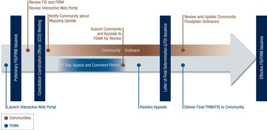
6 Consultation Coordination Officer (CCO) Meeting New/Updated FIRM release requires community adoption of these maps and a review/update of the current Flood Damage Prevention ordinance. CCO Meeting allows communities and FEMA to review the local responsibilities and statutory requirements related to map adoption and ordinance update 6
7 Middle Brazos Lake Whitney PMR - Overview Discovery Meeting for MBLW Sep 2014 Findings Meeting Feb 2015 Current Effective dates Hill County 6/2/2011 McLennan County 9/26/2008 Project Selection and Kick off Meeting Jun 2015 Used 2011 and 2013 LiDAR Non-Regulatory Flood Risk Products available on MSC Preliminary Map Released: Feb 15, 2018 Updated 46 panels Majority of both counties have updated Zone A mapping 7

8 Middle Brazos Lake Whitney PMR McLennan County Panels McLennan County 28 panels with Index Bellmead Beverly Hills Gholson Golinda Hallsburg Hewitt Lacy-Lakeview Leroy Lorena Reisel Robinson Ross Waco West Woodway McLennan County Unincorporated Areas 8

9 Middle Brazos Lake Whitney PMR Hill County Panels Hill County 18 panels with Index Abbott Bynum Carl s Corner Covington Hillsboro Itasca Mount Calm Penelope Whitney Hill County Unincorporated Areas 9

 Preliminary map for review Flood")


10 Regulatory Products Used to administer 44CFR and rate flood insurance. Includes: Flood Insurance Rate Map (FIRM) Preliminary map for review Flood Insurance Study (FIS) Text Overview of engineering analysis and approach DFIRM Database - Digital data on DVD Data is preliminary; comments and questions are welcomed! 10


11 Interactive Flood Information Portal Detailed Property Reports Preliminary FIRM Effective FIRM Change Layer User Fact sheet available: /documents/resour ce/what is you Flood Risk.pdf 11
12 Changes Since Last FIRM (CSLF) Proactive notification of residents and business owners of changes Informing development decisions and community planning Determining where flood mitigation is needed Review of flood profiles in local Hazard Mitigation Plans that may require updating Promotion of insurance/agent training in your area

13 How Flood Risk Products Help Help local business owners and residents: Understand current flood risk Enable informed decisions about protecting against that risk Aid communities and state officials Grant funding application review and selection process Identify mitigation actions Inform Hazard Mitigation Plans 13

14 Next Steps For Local Communities Review the revised preliminary products Outreach to citizens on risk of living behind levees and mapping efforts moving forward Communicate study results to residents and business owners Review current floodplain ordinances for any needed updates Consider local communications strategy for Open House, social media, community website Do collect appeal and comment cases from citizens and submit to FEMA during the regulatory 90-day appeal period 14

15 When does the Appeal Period Open? After Preliminary Issuance and CCO Meeting: Letter sent to Community Elected Official Federal Register Proposed Notice Printing Local Newspaper Printing twice within 10 days day appeal period initiates

16 Comment versus Appeal Comment Objection to base map feature/addition, update to FIS report material or other non-appealable change Road locations, road names, corporate limits, etc. Appeal Formal written objection to the addition/modification of a preliminary Base Flood Elevation/Flood Depth, Special Flood Hazard Boundary, Zone Designation or Regulatory floodway boundary. Appellants asked to demonstrate a different/more appropriate methodology, provide alternative analysis or data for use in updated FIRM. All appeals/comments should be reviewed by community prior to submittal to FEMA 16

17 Community Responsibilities Review of Preliminary FIRM/FIS, use interactive map viewers Provide appeals/comments to FEMA for review within 90 day period Compilation/review of all appeals/comments received. Submittal of appeal/comment suggests community support of appeal/comment Availability for review of appeal resolution outcomes Coordinate with local decision makers for map adoption and ordinance updates Update of local community ordinance and submittal to State/FEMA for review. 17
18 Summary of Map Actions - SOMA The SOMA provides a comprehensive list of previously issued Letters of Map Change (LOMC) for a community Assists community officials and property owners in determining the status of these LOMCs as a result of revisions to the FIRM. Local Communities should review their SOMA carefully FEMA (or its contractors) may reach out to determine if a community has older case files/documentation Preliminary SOMA review now Final SOMA prior to Effective Issuance Contact FEMA with concerns 18

19 Appeal and Comment Period Appeals and comments should be submitted within the 90-day appeal and comment period, in writing, to FEMA at: Mitigation Division Director c/o Lisa Jennings, Appeal Coordinator FEMA Region VI 800 North Loop 288 Denton, Texas


20 Scientific Resolution Panel Community can request SRP review of appeal if parties cannot come to an agreeable resolution Only applies to Appeal Submittals not Comments Must be community supported Received with the 90-day appeal period Submit an application available on website (see Fact Sheet) e5a fe301cef8bfab130b764a3/srp_overview_fixed_link.pdf 20
21 Post-Preliminary Process 21


22 Local Ordinances The local community has the RESPONSIBILITY and AUTHORITY to enforce its local provisions Proper permitting Inspections Certifications 22
 V or VE Zones FIS, BFE, plus Coastal (No Floodway) AE Zones FIS, BFE, plus Floodway Detailed studies 60.3(c) AE Zones FIS and BFE Detailed studies with BFEs 60.")
23 Ordinance Update Ordinance Level Auto Adopt Clause Regulation Staircase 44 CFR 60.3(a)-(e) 60.3(d) 60.3(e) V or VE Zones FIS, BFE, plus Coastal (No Floodway) AE Zones FIS, BFE, plus Floodway Detailed studies 60.3(c) AE Zones FIS and BFE Detailed studies with BFEs 60.3(b) Approximate Zone A Flood Hazard Boundary Map (FHBM) Identifies SFHA but has minimal accuracy no detailed study 60.3(a) No Flood Map NOTE: with no maps, there are no Special Flood Hazard Areas (SFHAs) 23
24 Ordinance Update Texas Community Floodplain Ordinance should be reviewed for update needs FEMA Model Ordinance available for use Auto-adopt allows automatic adoption without update of ordinance when FIRMs are revised FEMA compliance specialist and State NFIP coordinator will work to update ordinances as required 24

25 Consider Higher Standards Communities may adopt additional and more restrictive practices than outlined in the model ordinances. Communities may reach out to State or FEMA staff for draft language to include in ordinance updates. Within the State of Texas a number of higher standards have been adopted, to include: Study required in/around Zone A areas to establish BFE Elevation Certificates required prior to framing permits Freeboard above the Base Flood Elevation Open Space Planning Full build out conditions hydrology assessed Fill placed in floodplain requires mitigation 25

26 Ordinance Update Key Steps 26


27 Insurance Update Homeowners Flood Insurance Affordability Act - HFIAA HR3370 Signed into law March 21,
28 Mandatory Purchase When is flood insurance required? When a structure is located in a high risk flood zone (A, AE, etc.) and there is a federally backed loan Keep in mind that insurance risks are based on the current effective Flood Insurance Rate Map (FIRM) and not revised panels until issued effective If your community is participating, insurance is always available no matter if your property is located in a SFHA or not. 28

29 Eligibility Newly Mapped Properties newly mapped into the SFHA Structures that were in a B, C, D and X flood zones, but now indicated in newly mapped into the A or V flood zones Certain Properties not eligible for Newly Mapped Structures located in communities that are participating in Emergency Program Multi Unit Residential condos insured under Residential Condominium Building Association Policy (RCBAP) 29
30 Risk Communication Link local websites to this interactive flood map index on FEMA s RiskMap6.com website: Interactive Flood Map Index Newsletters, Fact sheets, and Handouts 30


31 Risk Communications Guidebook Online access to tools, templates to communicate risk with residents and business owners: Post-Preliminary Toolkit Press Releases Web Content Talking Points Social Media messages Facebook and Twitter Community Outreach Strategy Template Communication Technical Assistance Available to Local Community Officials 31
32 Community Support Contacts - TX Engineering and Mapping john.bourdeaujr@fema.dhs.gov Compliance Specialist charla.marchuk@fema.dhs.gov Insurance Specialist mark.lujan@fema.dhs.gov Compliance Team Leads david.hiegel@fema.dhs.gov lisa.jennings@fema.dhs.gov Mitigation Planning jamie.price@fema.dhs.gov Outreach cynthia.wirz@fema.dhs.gov

33 Questions? 33
Cameron County, TX. Consultation Coordination Officer (CCO) Meeting. Please sign in (sheet at front of the room) Meeting will begin at 9:00
 Meeting. Please sign in (sheet at front of the room) Meeting will begin at 9:00") Cameron County, TX Consultation Coordination Officer (CCO) Meeting Please sign in (sheet at front of the room) Meeting will begin at 9:00 July 29, 2015 Lisa Jennings FEMA Region 6 Roles & Responsibilities
Cameron County, TX Consultation Coordination Officer (CCO) Meeting Please sign in (sheet at front of the room) Meeting will begin at 9:00 July 29, 2015 Lisa Jennings FEMA Region 6 Roles & Responsibilities
LOCAL OFFICIALS MEETING Lake Wausau Physical Map Revision MARATHON COUNTY, WISCONSIN FEBRUARY 9, 2017
 LOCAL OFFICIALS MEETING Lake Wausau Physical Map Revision MARATHON COUNTY, WISCONSIN FEBRUARY 9, 2017 Welcome & Introduction Michelle Staff Floodplain Management Policy Coordinator, WDNR Michelle.Staff@Wisconsin.gov
Durham County Preliminary Flood Hazard Data Public Meeting. July 28, 2016
 Durham County Preliminary Flood Hazard Data Public Meeting July 28, 2016 Why Are We Here New flood hazard data has been released as Preliminary for Durham County Statutory Due Process for review/comments
Preliminary DFIRM Community Coordination (PDCC) Meeting Gilchrist & Levy Counties, FL. April 30, 2015
 Meeting Gilchrist & Levy Counties, FL. April 30, 2015") Preliminary DFIRM Community Coordination (PDCC) Meeting Gilchrist & Levy Counties, FL April 30, 2015 Agenda 1. Introductions 2. Study Process and Timeline 3. Overview of Preliminary Products 4. Overview
Preliminary DFIRM Community Coordination (PDCC) Meeting Gilchrist & Levy Counties, FL April 30, 2015 Agenda 1. Introductions 2. Study Process and Timeline 3. Overview of Preliminary Products 4. Overview
Kevin Wagner Maryland Department of the Environment
 Kevin Wagner Maryland Department of the Environment Topics Overview of the National Flood Insurance Program (NFIP) Mapping Regulations Insurance Mitigation Community Rating System (CRS) Questions Know
Georgia Flood M.A.P. Program Risk MAP Plenary Session GAFM 2011
 Georgia Flood M.A.P. Program Risk MAP Plenary Session GAFM 2011 Collis Brown, Georgia DNR March 24, 2011 GA Flood Map Modernization Responsible for end-to-end production Developed aggressive outreach program
Taylor County, Florida Community Coordination and Outreach (CCO) Meeting
 Meeting") Taylor County, Florida Community Coordination and Outreach (CCO) Meeting Suwannee River Water Management District April 26, 2017 11:00AM to 12:00PM Taylor County Administration Building, 201 E. Green Street,
Taylor County, Florida Community Coordination and Outreach (CCO) Meeting Suwannee River Water Management District April 26, 2017 11:00AM to 12:00PM Taylor County Administration Building, 201 E. Green Street,
9/20/2016. Orange County Preliminary FIRM / Consultation Coordination Officer (CCO) Meeting
 Meeting") Orange County Preliminary FIRM / Consultation Coordination Officer (CCO) Meeting Open Pacific Coast Study September 21 and 22, 2016 1 Welcome and Introductions Preliminary FIRM / CCO Meeting Orange County
Orange County Preliminary FIRM / Consultation Coordination Officer (CCO) Meeting Open Pacific Coast Study September 21 and 22, 2016 1 Welcome and Introductions Preliminary FIRM / CCO Meeting Orange County
Nassau County, Florida Consultation Coordination Officer (CCO) Meeting. February 24, 2016 Fernandina Beach, Florida
 Meeting. February 24, 2016 Fernandina Beach, Florida") Nassau County, Florida Consultation Coordination Officer (CCO) Meeting February 24, 2016 Fernandina Beach, Florida Agenda Introductions Coastal Study Update Study Process and Timeline Flood Insurance Implications
Nassau County, Florida Consultation Coordination Officer (CCO) Meeting February 24, 2016 Fernandina Beach, Florida Agenda Introductions Coastal Study Update Study Process and Timeline Flood Insurance Implications
Bullitt County, Kentucky Preliminary DFIRM Community Open House. October 8, 2014 Shepherdsville, Kentucky
 Bullitt County, Kentucky Preliminary DFIRM Community Open House October 8, 2014 Shepherdsville, Kentucky Meeting Agenda Introductions Overview of Preliminary DFIRMs Overview of Map Appeal Process Questions
Georgia Flood M.A.P. Program
 Georgia Flood M.A.P. Program Georgia Flood M.A.P. Program The Upper Chattahoochee River Basin Risk MAP Project Transitioning State Program to align with FEMA s Risk MAP Program Increase focus on risk assessment
Chapter 7 Appendix B: National Flood Insurance Program Summary for Kaua'i County, 2015 Update
 Chapter 7 Appendix B: National Flood Insurance Program Summary for Kaua'i County, 2015 Update Topic Considerations Description INSURANCE SUMMARY STAFF RESOURCES How many NFIP policies are in Kaua i County?
Outreach Georgia Flood M.A.P. Program. GAFM Technical Conference Flood Risk Outreach and Policy Session
 Outreach Georgia Flood M.A.P. Program GAFM Technical Conference Flood Risk Outreach and Policy Session 7 th Annual Technical Conference, Lanier Islands March 29, 2012 Risk Communication Key Learnings People
Community Officials Meeting. Plumas and Sierra County Physical Map Revision
 Community Officials Meeting Plumas and Sierra County Physical Map Revision March 6, 2014 Agenda Introductions/Sign In Project Scope Sierra Valley Flood Study (Plumas and Sierra Counties) North Yuba River
Abington Township Public Meeting
 Abington Township Public Meeting Flood Insurance Rate Map Update March 23, 2016 1 Meeting Agenda and Format Provide residents/property owners of Abington Township with information about the map update,
Kentucky Risk MAP It s not Map Mod II
 Kentucky Risk MAP It s not Map Mod II Risk Mapping Assessment and Planning Carey Johnson Kentucky Division of Water carey.johnson@ky.gov What is Risk MAP? Risk Mapping, Assessment, and Planning (Risk MAP)
Middlesex County Timeline
 Community Coordination Meeting for Middlesex County, Connecticut Risk MAP Study November 9, 2011 Agenda Welcome and Introductions Project Timeline Coastal Flood Hazard Analysis Recap Public Review and
Door County Floodplain Program Informational Meeting
 Door County Floodplain Program Informational Meeting Door County Land Use Services Department Wisconsin Department of Natural Resources January 15, 2018 Floodplain = Land affected by flood event with a
Changes to the National Flood Insurance Program What to Expect
 Changes to the National Flood Insurance Program What to Expect Impact of changes to the NFIP under Homeowner Flood Insurance Affordability Act of 2014 More Changes are Coming to the NFIP On March 21, 2014,
St. Johns County, Florida Consultation Coordination Officer (CCO) Meeting. August 31, 2016 St. Augustine, Florida
 Meeting. August 31, 2016 St. Augustine, Florida") St. Johns County, Florida Consultation Coordination Officer (CCO) Meeting August 31, 2016 St. Augustine, Florida Agenda Introductions Coastal Study Update Study Process and Timeline Flood Insurance Implications
St. Johns County, Florida Consultation Coordination Officer (CCO) Meeting August 31, 2016 St. Augustine, Florida Agenda Introductions Coastal Study Update Study Process and Timeline Flood Insurance Implications
Natchitoches Parish, Louisiana Flood Insurance Study Update Risk Analysis March 3, Shona Gibson Project Monitor, FEMA Region VI
 Natchitoches Parish, Louisiana Flood Insurance Study Update Risk Analysis Shona Gibson Project Monitor, FEMA Region VI Presentation Overview Introductions Why are we here? Levee Status and Opportunities
Flood Hazard Risk Mapping:
 Mitigation Division Flood Hazard Risk Mapping: Past, Present and Future Oklahoma Floodplain Management Association Ron Wanhanen, PE FEMA Region 6 Risk Analysis Branch Overview The Past The Present Risk
Floodplain Management 101. Mississippi Emergency Management Agency Floodplain Management Bureau
 Floodplain Management 101 Mississippi Emergency Management Agency Floodplain Management Bureau Stafford Act The Stafford Disaster Relief and Emergency Assistance Act (Stafford Act) (Public Law 100-707)
Changes to the National Flood Insurance Program What to Expect
 Changes to the National Flood Insurance Program What to Expect Impact of changes to the NFIP under Homeowner Flood Insurance Affordability Act of 2014 BW-12: What Changed Subsidies to be phased out Non-primary
Duval County, Florida Consultation Coordination Officer (CCO) Meeting. January 25, 2017 Jacksonville, Florida
 Meeting. January 25, 2017 Jacksonville, Florida") Duval County, Florida Consultation Coordination Officer (CCO) Meeting January 25, 2017 Jacksonville, Florida Agenda Introductions Coastal Study Update Study Process and Timeline Flood Insurance Implications
Duval County, Florida Consultation Coordination Officer (CCO) Meeting January 25, 2017 Jacksonville, Florida Agenda Introductions Coastal Study Update Study Process and Timeline Flood Insurance Implications
Federal Emergency Management Agency
 Page 1 of 4 Issue Date: September 7, 2012 Effective Date: January 22, 2013 DETERMINATION DOCUMENT COMMUNITY COMMUNITY AND REVISION INFORMATION City of Lubbock Lubbock County Texas PROJECT DESCRIPTION CHANNELIZATION
Now You re Cooking! Recipes for Resilience. Jerri Daniels, Dewberry Diane Howe, FEMA Region 6
 Now You re Cooking! Recipes for Resilience Jerri Daniels, Dewberry jdaniels@dewberry.com Diane Howe, FEMA Region 6 diane.howe@fema.dhs.gov I ve lived here all my life 2 Who loves to cook? 3 Ingredients
Federal Emergency Management Agency
 Page 1 of 4 Issue Date: April 26, 2013 DETERMINATION DOCUMENT COMMUNITY AND REVISION INFORMATION PROJECT DESCRIPTION BASIS OF REQUEST City of Coppell Dallas County Texas FILL HYDRAULIC ANALYSIS NEW TOPOGRAPHIC
Tarrant County, TX Monthly Progress Report No. 33 (FEMA Contract No, HSFEHQ-09-D-0369) Task Order 01
 Task Order 01") Tarrant County, TX Monthly Progress Report No. 33 (FEMA Contract No, HSFEHQ-09-D-0369) Task Order 01 Period of Coverage: June 1, 2012 June 30, 2012 of Submittal: July 2, 2012 Submitted To: Ron Wanhanen
Tarrant County, TX Monthly Progress Report No. 33 (FEMA Contract No, HSFEHQ-09-D-0369) Task Order 01 Period of Coverage: June 1, 2012 June 30, 2012 of Submittal: July 2, 2012 Submitted To: Ron Wanhanen
NFIP Program Basics. KAMM Regional Training
 NFIP Program Basics KAMM Regional Training Floodplain 101 Homeowners insurance does not cover flood damage Approximately 25,000 flood insurance policies in KY According to BW12 analysis, approximately
SECTION 9: MAPS AND DATA
 SECTION 9: MAPS AND DATA Contents 9.1. NFIP Maps and Data... 9-2 9.1.1. Adopting and enforcing NFIP floodplain maps and data... 9-2 9.1.2. Adopting and enforcing more restrictive data... 9-2 9.1.3. Annexations...
REAL ESTATE FLOOD DISCLOSURE PROGRAM & FLOOD MAP INFORMATION SERVICES
 REAL ESTATE FLOOD DISCLOSURE PROGRAM & FLOOD MAP INFORMATION SERVICES Lisa Foster, CFM, Floodplain Coordinator ldfoster@pinellascounty.org January 26, 2018 Why are you here? Save your clients money on
National Flood Insurance Program. Jennifer Gilbert, CFM, ANFI New Hampshire NFIP State Coordinator
 National Flood Insurance Program Jennifer Gilbert, CFM, ANFI New Hampshire NFIP State Coordinator What is the National Flood Insurance Program? Created by Congress in 1968 Participating Communities voluntarily
F E M A Mapping Changes. FEMA Mapping Changes. National Flood Insurance Program
 FEMA Mapping Changes National Flood Insurance Program 1 Welcome to FEMA Mapping Changes! We will get started in a few minutes. Meanwhile, let s perform a warm up exercise. 2 1 Training Agenda Section 1-
Flood Risk Review (FRR) Meeting. Cumberland County, Pennsylvania Carlisle, Pennsylvania December 5, 2016
 Meeting. Cumberland County, Pennsylvania Carlisle, Pennsylvania December 5, 2016") Flood Risk Review (FRR) Meeting Cumberland County, Pennsylvania Carlisle, Pennsylvania December 5, 2016 Why are we here today? The Flood Insurance Study (FIS) report and Flood Insurance Rate Maps (FIRMs)
Flood Risk Review (FRR) Meeting Cumberland County, Pennsylvania Carlisle, Pennsylvania December 5, 2016 Why are we here today? The Flood Insurance Study (FIS) report and Flood Insurance Rate Maps (FIRMs)
Orleans Parish, LA Initial Coordination Meeting Preliminary DFIRM Update September 29, 2011
 Orleans Parish, LA Initial Coordination Meeting Preliminary DFIRM Update September 29, 2011 Introductions Project History Description of Update Effort Project Benefits Project Schedule How You Can Help
Federal Emergency Management Agency
 Page 1 of 5 Issue Date: July 27, 2012 Effective Date: December 10, 2012 Case No.: 11-06-4512P Follows Conditional Case No.: 06-06-B789R LOMR-APP Federal Emergency Management Agency Washington, D.C. 20472
NFIP Mapping Issues. Wendy Lathrop, PLS, CFM. Cadastral Consulting, LLC
 NFIP Mapping Issues Cadastral Consulting, LLC NFIP Basic Objectives: Reduce the exposure to flood damages through the use of minimum standards for the placement and design of structures located in flood
Bucks County, PA Flood Risk Review Meeting. November 2014
 Bucks County, PA Flood Risk Review Meeting November 2014 Agenda for Today Risk MAP Program overview Overview of non-regulatory Flood Risk Products and datasets Discuss mitigation action Technical overview
Federal Emergency Management Agency
 Page 1 of 5 Issue Date: June 21, 2013 Follows Conditional Case No.: 04-06-A148R DETERMINATION DOCUMENT COMMUNITY COMMUNITY AND REVISION INFORMATION City of Irving Dallas County Texas FILL PROJECT DESCRIPTION
JAXGIS FEMA Flood Hazard Mapping -- Frequently Asked Questions
 Flood Hazard Zone Designations Summary Zones starting with the letter 'A' (for instance, Zone A, Zone AE, Zone AH, Zone AO) denote a Special Flood Hazard Area, which can also be thought of as the 100-year
Floodplain Manager s Toolkit Unlocking the Hidden Potential of Floodplain Data for Your Community
 Floodplain Manager s Toolkit Unlocking the Hidden Potential of Floodplain Data for Your Community TFMA South Central Lunch Event San Antonio, TX June 12, 2014 Jessica D. Baker, PE, CFM, PMP Samuel Amoako-Atta,
Community Coordination Meeting. York County, Maine. Risk MAP Study
 Community Coordination Meeting York County, Maine Risk MAP Study January 9, 2014 Agenda Welcome and Introductions Project Timeline Flood Hazard Analysis Recap (Digital Conversion, Riverine and Coastal)
Physical Map Revisions as a Result of Updated Coastal Flood Hazards
 Physical Map Revisions as a Result of Updated Coastal Flood Hazards Agenda Coastal Flood Hazard Analysis Recap Public Review and Appeal Period Effect on Existing Letters of Map Change Insurance Questions
Federal Emergency Management Agency
 Page 1 of 4 Issue Date: October 2, 2017 Effective Date: October 2, 2017 Case No.: 17-09-2731P LOMR-APP Federal Emergency Management Agency Washington, D.C. 20472 LETTER OF MAP REVISION DETERMINATION DOCUMENT
King County, WA DFIRM Update and Seclusion Process. Webinar June 14, 2016
 King County, WA DFIRM Update and Seclusion Process Webinar June 14, 2016 Agenda King County DFIRM Study History What is/has been done Process for moving forward Seclusion Seclusion mapping process Seclusion
Skagit County Flood Insurance Study Update. Ryan Ike, CFM FEMA Region 10
 Skagit County Flood Insurance Study Update Ryan Ike, CFM FEMA Region 10 Skagit County Flood Insurance Study Process Overview Process, Schedule, & Deliverables Base Flood Elevations, Modeling, & Levees
Federal Emergency Management Agency
 Page 1 of 6 Issue Date: October 24, 2012 Effective Date: March 7, 2013 Case No.: LOMR-APP DETERMINATION DOCUMENT COMMUNITY AND REVISION INFORMATION PROJECT DESCRIPTION BASIS OF REQUEST City of Lubbock
WAYNE COUNTY COMMUNITY CONSULTATION OFFICERS (CCO) MEETING. February 27, 2019
 MEETING. February 27, 2019") WAYNE COUNTY COMMUNITY CONSULTATION OFFICERS (CCO) MEETING February 27, 2019 TODAY S AGENDA Review the Updated Flood Risk Data for Your County Next Steps in the Map Adoption Process Understanding Flood
WAYNE COUNTY COMMUNITY CONSULTATION OFFICERS (CCO) MEETING February 27, 2019 TODAY S AGENDA Review the Updated Flood Risk Data for Your County Next Steps in the Map Adoption Process Understanding Flood
Federal Emergency Management Agency
 Page 1 of 5 Issue Date: April 2, 2015 DETERMINATION DOCUMENT COMMUNITY AND REVISION INFORMATION PROJECT DESCRIPTION BASIS OF REQUEST Ventura County California NO PROJECT UPDATE COMMUNITY (Unincorporated
Federal Emergency Management Agency
 Page 1 of 4 Issue Date: February 14, 2013 Effective Date: June 28, 2013 DETERMINATION DOCUMENT COMMUNITY AND REVISION INFORMATION City of Sunny Isles Beach Miami-Dade County Florida PROJECT DESCRIPTION
National Flood Insurance Program (NFIP) for Real Estate Professionals
 for Real Estate Professionals") National Flood Insurance Program (NFIP) for Real Estate Professionals 1 Joshua Oyer, CFM Outreach Specialist NFIP State Coordinator s Office at the Texas Water Development Board 2 Outline Introduction
National Flood Insurance Program (NFIP) for Real Estate Professionals 1 Joshua Oyer, CFM Outreach Specialist NFIP State Coordinator s Office at the Texas Water Development Board 2 Outline Introduction
BEING PREPARED FOR MAP CHANGES What to Know; What to Say National Flood Conference May 16, 2016
 BEING PREPARED FOR MAP CHANGES What to Know; What to Say National Flood Conference May 16, 2016 0 Discussion Topics Risk MAP Program Background Eric Simmons FEMA Region 9 Map Change Rating Options Edie
OTTAWA COUNTY AND SANDUSKY COUNTY COMMUNITY CONSULTATION OFFICERS (CCO) MEETING December 7, 2017
 MEETING December 7, 2017") OTTAWA COUNTY AND SANDUSKY COUNTY COMMUNITY CONSULTATION OFFICERS (CCO) MEETING December 7, 2017 TODAY S AGENDA The Value of Updated Flood Maps for Your Community Reviewing the Updated Flood Risk Data
OTTAWA COUNTY AND SANDUSKY COUNTY COMMUNITY CONSULTATION OFFICERS (CCO) MEETING December 7, 2017 TODAY S AGENDA The Value of Updated Flood Maps for Your Community Reviewing the Updated Flood Risk Data
FOR LOCAL GOVERNMENTS
 FLOOD MAP OUTREACH PLANNING GUIDEBOOK FOR LOCAL GOVERNMENTS Version 1.1 Georgia Department of Natural Resources March 2010 Dear Community Official: Georgia s Department of Natural Resources (DNR) has partnered
Questions about the National Flood Insurance Program
 Questions about the National Flood Insurance Program Federal Emergency Management Agency (FEMA) Questions and Answers What is the National Flood Insurance Program (NFIP)? The NFIP is a Federal program
Floodplain Management 101: UNIT II. Maps & Flood Insurance Studies
 Floodplain Management 101: UNIT II Maps & Flood Insurance Studies Who is ASFPM? ASFPM stands for the Association of State Floodplain Managers A national organization of floodplain management professionals
Community Coordination Meeting Sagadahoc County, Maine
 Community Coordination Meeting Sagadahoc County, Maine Risk MAP Study April 2, 2014 Agenda Welcome and Introductions Project Timeline Flood Hazard Analysis Recap Flood Risk Products Action: Hazard Mitigation
REAL ESTATE FLOOD DISCLOSURE PROGRAM & FLOOD MAP INFORMATION SERVICES
 REAL ESTATE FLOOD DISCLOSURE PROGRAM & FLOOD MAP INFORMATION SERVICES Agenda 10:30-12:00 Flood Disclosure Program 12:00-12:30 Lunch 12:30-1:30 Flood Map Service Center Lisa Foster, CFM, Floodplain Coordinator
Requirements for Construction on Properties in the Special Flood Hazard Area (SFHA)
") Requirements for Construction on Properties in the Special Flood Hazard Area (SFHA) Rev 010915 The website for the IDNR to request the EFARA (Electronic Floodplain Analysis/Regulatory Assessment is found
Requirements for Construction on Properties in the Special Flood Hazard Area (SFHA) Rev 010915 The website for the IDNR to request the EFARA (Electronic Floodplain Analysis/Regulatory Assessment is found
Community Rating System. National Flood Insurance Program
 National Flood Insurance Program Community Rating System A Local Official s Guide to Saving Lives Preventing Property Damage Reducing the Cost of Flood Insurance FEMA B-573 / May 2015 How the Community
Flood Risk Outreach Tools for Georgia Communities. GAFM 10 th Annual Conference Presented By: Jarrett Mattli
 Flood Risk Outreach Tools for Georgia Communities GAFM 10 th Annual Conference Presented By: Jarrett Mattli April 13, 2016 Presentation Overview Guidebooks Toolkits Templates Educational Videos Resource
Updates to Maine Coastal Flood Insurance Rate Maps (FIRM s): What a Local Official Should Know. Presented by: Steve Johnson, P.E.
: What a Local Official Should Know. Presented by: Steve Johnson, P.E.") Updates to Maine Coastal Flood Insurance Rate Maps (FIRM s): What a Local Official Should Know Presented by: Steve Johnson, P.E. Town Engineer October 4, 2018 Introduction Federal Emergency Management
Updates to Maine Coastal Flood Insurance Rate Maps (FIRM s): What a Local Official Should Know Presented by: Steve Johnson, P.E. Town Engineer October 4, 2018 Introduction Federal Emergency Management
Federal Emergency Management Agency
 Page 1 of 6 Issue Date: September 27, 2010 Effective Date: February 14, 2011 Follows Conditional Case No.: 08-08-0873R DETERMINATION DOCUMENT COMMUNITY AND REVISION INFORMATION PROJECT DESCRIPTION BASIS
ASFPM Update and NFIP Reform. KAMM 10 th Anniversary Conference September 9, 2014
 ASFPM Update and NFIP Reform KAMM 10 th Anniversary Conference September 9, 2014 AND HE SAID Floods are 'acts of God,' but flood losses are largely acts of man. 1945 PhD Dissertation Human Adjustments
Flood Map Revisions. Town of Nags Head Public Information and Input Session. December 14, 2016, 6 pm
 Flood Map Revisions Town of Nags Head Public Information and Input Session December 14, 2016, 6 pm Flood Map Revisions New preliminary flood maps released for Dare County June 30, 2016 www.nagsheadnc.gov/floodmaps
Enough about me! Topics Covered
 About Me Worked in land surveying since 1997 Employed by the City of Orlando since 2006 City of Orlando City Surveyor since February 2015 Certified Floodplain Manager since 2015 Florida Licensed Surveyor,
Federal Emergency Management Agency
 Page 1 of 5 Issue Date: October 28, 2009 Follows Conditional Case No.: 08-08-0612R DETERMINATION DOCUMENT COMMUNITY AND REVISION INFORMATION PROJECT DESCRIPTION BASIS OF REQUEST COMMUNITY Lincoln County
Best Practices. for Incorporating Building Science Guidance into Community Risk MAP Implementation November 2012
 Best Practices for Incorporating Building Science Guidance into Community Risk MAP Implementation November 2012 Federal Emergency Management Agency Department of Homeland Security 500 C Street, SW Washington,
RichSmith_slate-FEMA_320x240.wmv.
 Nebraska DNR s role in the making of FEMA s Digital Flood Insurance Rate Maps Becky Groshens (grow-hands) & Shelley Schindler Important Terms: FIRM: Flood Insurance Rate Map FIS: Flood Insurance Study
ASFPM REGION 6 DIRECTOR ANNUAL REPORT. Annual Conference-Atlanta, Georgia
 ASFPM REGION 6 DIRECTOR ANNUAL REPORT Annual Conference-Atlanta, Georgia Jessica Baker, Regional Director 5/31/2015 ASFPM REGION 6 DIRECTOR ANNUAL REPORT Annual Conference-Atlanta, Georgia Region 6 Report
Federal Emergency Management Agency
 Page 1 of 4 Issue Date: August 1, 2012 Effective Date: December 13, 2012 Case No.: 12-06-0595P LOMR-APP Washington, D.C. 20472 LETTER OF MAP REVISION DETERMINATION DOCUMENT COMMUNITY AND REVISION INFORMATION
July 31, 2017 NFIP Flood Map Open House Flood Maps 101 Flood Mapping acronyms History of the NFIP Flood Mapping Updates Flood Insurance Fairhope,
 July 31, 2017 NFIP Flood Map Open House Flood Maps 101 Flood Mapping acronyms History of the NFIP Flood Mapping Updates Flood Insurance Fairhope, Alabama Flood Maps Fairhope Permitting Jurisdiction Coastal
Federal Emergency Management Agency
 Page 1 of 4 Issue Date: April 11, 2013 Case No.: DETERMINATION DOCUMENT COMMUNITY AND REVISION INFORMATION PROJECT DESCRIPTION BASIS OF REQUEST Town Of Stratford Fairfield County Connecticut NO PROJECT
Federal Emergency Management Agency
 Page 1 of 4 Issue ate: May 18, 2012 Follows Conditional Case No.: 08-06-1597R ETERMINATION OCUMENT COMMUNITY AN REVISION INFORMATION PROJECT ESCRIPTION BASIS OF REQUEST COMMUNITY Harris County Texas (Unincorporated
AMENDMENTS TO CHAPTER 50: FLOODPLAIN DEVELOPMENT
 AMENDMENTS TO CHAPTER 50: FLOODPLAIN DEVELOPMENT PART I: 2018 FLOOD MAP IMPLEMENTATION PART II: STRATEGIES TO IMPROVE THE CITY S COMMUNITY RATING SYSTEM SCORE NATIONAL FLOOD INSURANCE PROGRAM (NFIP) CREATED
The National Flood Insurance Program and Flood Insurance Rate Map for San Francisco. Presentation at Treasure Island Community Meeting
 The National Flood Insurance Program and Flood Insurance Rate Map for San Francisco Presentation at Treasure Island Community Meeting October 17, 2007 1 National Flood Insurance Program (NFIP) Overview
Introduction to the National Flood Insurance Program: A Guide for Coastal Property Owners MAINE BEACHES CONFERENCE 2017
 Introduction to the National Flood Insurance Program: A Guide for Coastal Property Owners MAINE BEACHES CONFERENCE 2017 SUE BAKER, CFM STATE NFIP COORDINATOR MAINE DEPT OF AGRICULTURE, CONSERVATION & FORESTRY
ASFPM Partnerships for Statewide Mitigation Actions. Alicia Williams GIS and HMP Section Manager, Amec Foster Wheeler June 2016
 ASFPM Partnerships for Statewide Mitigation Actions Alicia Williams GIS and HMP Section Manager, Amec Foster Wheeler June 2016 Summary The Concept Leveraging Existing Data and Partnerships to reduce risk
NFIP: October 2016 Updates and Community Decision Impacts on Individual Rates
 NFIP: October 2016 Updates and Community Decision Impacts on Individual Rates Carl Watts, Regional Liaison NFIP-iService, Region VI cwatts@nfip-iservice.com P: 405-257-9000 1 1 NFIP: Review and October
What Was Updated in 2004 in Hennepin Countywide Maps?
 What Was Updated in 2004 in Hennepin Countywide Maps? Combined the city and township maps into one countywide index Done by USACE Mainly digital capture of old floodplain boundaries; some spots with shifts
Use of FEMA Non regulatory Flood Risk Products in Planning
 Use of FEMA Non regulatory Flood Risk Products in Planning Georgia Association of Floodplain Managers Annual Conference March 24, 2016 What are the Non regulatory Flood Risk products? Go beyond the basic
Floodplain Management. City Council Work Session April 16, 2013
 Floodplain Management City Council Work Session April 16, 2013 1 Discussion Agenda Flood Insurance Rate Changes Community Rating System Recommendation Floodplain Ordinance Enhancements Modifications Public
Strategies for Data Sharing
 Proud Titanium Sponsor of the ASFPM 2016 Annual Conference Strategies for Data Sharing Vince Geronimo, PE, CFM Operations Manager, Oakland, CA Krista Bethune Melnar, PE, CFM Technical Director, Water,
History of Floodplain Management in Ascension Parish
 History of Floodplain Management in Ascension Parish presented by: Kara Moree Floodplain Coordinator February 6, 2012 Floodplain 101 Floodplain 101 Base or 1% Flood: A flood having a 1% chance of being
CITY OF PLANTATION ENGINEERING DEPARTMENT INTEROFFICE MEMORANDUM NO
 CITY OF PLANTATION ENGINEERING DEPARTMENT INTEROFFICE MEMORANDUM NO. 2013-003 DATE: October 22, 2012 TO: Mayor and Members of City Council FROM: Brett W. Butler, PE, CFM City Engineer SUBJECT: CRS Program
Herkimer County, New York Flood Hazard Mapping Status Report for Property Owners
 Herkimer County, New York Flood Hazard Mapping Status Report for Property Owners Herkimer County, New York Flood Hazard Mapping Status Report for Property Owners FLOOD INSURANCE Who Should Purchase Flood
North Carolina Department of Public Safety Emergency Management Risk Management
 North Carolina Department of Public Safety Emergency Management Risk Management Roy Cooper, Governor Erik A. Hooks, Secretary Michael A. Sprayberry, Director INSTRUCTIONS FOR COMPLETING THE NORTH CAROLINA
Federal Emergency Management Agency
 Page 1 of 5 Issue Date: October 16, 2014 Effective Date: March 2, 2015 Case No.: 14-09-2279P LOMR-APP Federal Emergency Management Agency Washington, D.C. 20472 LETTER OF MAP REVISION DETERMINATION DOCUMENT
Using GISWeb to Determine Your Property s Flood Zone
 Using GISWeb to Determine Your Property s Flood Zone 1. In a new browser window, go to http://www.co.santacruz.ca.us/departments/geographicinformationsystemsgis.aspx 2. Click on GISWeb - GIS Mapping Application
Federal Emergency Management Agency
 Page 1 of 4 Issue Date: November 16 2016 Effective Date: March 31 2017 Case No: 16-06-2056P LOMR-APP Follows Conditional Case No: 10-06-3320R Federal Emergency Management Agency Washington DC 20472 LETTER
AGENDA. Floodplain Manager s Toolkit Unlocking the Hidden Potential of Floodplain Data for Your Community
 Floodplain Manager s Toolkit Unlocking the Hidden Potential of Floodplain Data for Your Community TFMA Spring Conference May 29, 2014 Jessica D. Baker, PE, CFM, PMP Samuel Amoako-Atta, GISP, CFM Eric Hajek,
Repetitive Loss Area Revisit # 6 Walter Road Area Jefferson Parish
 Repetitive Loss Area Revisit # 6 Walter Road Area Jefferson Parish www.floodhelp.uno.edu Supported by FEMA Acknowledgement The compilation if this report was managed by Erin Patton, CFM, a UNO-CHART Research
National Flood Insurance Program
 National Flood Insurance Program A Discussion in Three Parts: The Nature of Flood Risk An Overview of the NFIP Impact of Recent Legislation (BW-12 & HFIAA-14) Nature of Flood Risk FLOODS ARE AN ACT OF
Non Regulatory Risk MAP Products Flood Depth and Probability Grids
 Non Regulatory Risk MAP Products Flood Depth and Probability Grids Virginia Floodplain Management Association 2015 Floodplain Management Workshop October 29th, 2015 Nabil Ghalayini, P.E., PMP, D.WRE, CFM
FEMA Region IX May 30-31, 2017
 Ventura County Preliminary Flood Maps FEMA Region IX May 30-31, 2017 National Flood Insurance Program U.S. Congress established the NFIP with the passage of the National Flood Insurance Act of 1968: 1.
FLOODPLAIN FAQ s. Last Update: June 2017
 FLOODPLAIN FAQ s Last Update: June 2017 What does FEMA stand for? Federal Emergency Management Agency - the operation of FEMA is to lead America to prepare for, prevent, respond to, and recover from disasters.
PARK COUNTY, WYOMING AND INCORPORATED AREAS
 PARK COUNTY, WYOMING AND INCORPORATED AREAS Community Name Community Number CODY, CITY OF 560038 MEETEETSE, TOWN OF 560039 PARK COUNTY UNINCORPORATED AREAS 560085 POWELL, CITY OF 560040 June 18, 2010 Federal
Martin County, Florida Consultation Coordination Officer (CCO) Meeting. March 22, 2018 Stuart, Florida
 Meeting. March 22, 2018 Stuart, Florida") Martin County, Florida Consultation Coordination Officer (CCO) Meeting March 22, 2018 Stuart, Florida Agenda Introductions Coastal Flood Risk Study Review Data Collected Storm Surge Modeling Overland Wave
Martin County, Florida Consultation Coordination Officer (CCO) Meeting March 22, 2018 Stuart, Florida Agenda Introductions Coastal Flood Risk Study Review Data Collected Storm Surge Modeling Overland Wave
David A. Stroud, CFM AMEC Earth & Environmental Raleigh, NC
 David A. Stroud, CFM AMEC Earth & Environmental Raleigh, NC Objectives Risk MAP background North Carolina s Risk MAP role Role of communication in Risk MAP Effective risk communication two examples Multi-hazard