King County, WA DFIRM Update and Seclusion Process. Webinar June 14, 2016
|
|
|
- Lucinda Todd
- 5 years ago
- Views:
Transcription


1 King County, WA DFIRM Update and Seclusion Process Webinar June 14, 2016


2 Agenda King County DFIRM Study History What is/has been done Process for moving forward Seclusion Seclusion mapping process Seclusion Criteria Areas to be Secluded Areas that are eligible for a Provisionally Accredited Levee Status Timeline for update
3 King County DFIRM Timeline History Scoping Meeting July 27, 2005 Levee Certification Documentation Needs Identified April 2006 Preliminary Map Release September 2007 King County Appeal February 2008 Revised Preliminary Map Release November 8, 2010 CCO Meeting November 29, 2010 Public Meeting Auburn January 26, 2011 Public Meeting Renton January 27, 2011 Public Meeting Kent February 7, 2011 FEMA Letter to Senators on Levee Policy March 2011
4 Map Modernization Process What s new New maps are county-wide Follows a USGS Quad layout countywide coverage with no city cut-outs Contains 100- & 500-year floodplains (AE/X zones) 10, 50, 100, 500 year flood elevations published Re-delineation of flooding sources where better topography was available Vertical Datum change (NGVD 1929 to NAVD 1988)
5 What s new Vertical Datum Change NGVD 29 Based on a mean sea level from 21 tidal stations in the US & 5 stations in Canada NAVD 88 Based on the density of the Earth instead of varying values of sea heights More accurate Conversion for King County Varies NGVD + (vertical adjustment ) = NAVD Conversion factor for County for FIS ranges from 3.5 to 4.1 feet
6 Digital Flood Insurance Rate Maps Vertical Datum and FIRMs (e.g. uses 3.8 conversion) NGVD 29 NAVD BFE = 2 ft BFE = 5.8 ft

7 Digital Flood Insurance Rate Maps Digital Format Special Flood Hazard Areas Land Ownership Transportation Surface Waters Boundaries Geodetic Control Elevation Aerial Imagery

8
9

10 Digital Flood Insurance Rate Maps Apply local parcel and topo layers
11 Digital Flood Insurance Rate Maps Zone Designation Changes Old FIRMs New FIRMs Definition A A Approximate Floodplain (SFHA) A1- A30 AE Detail River Floodplain (SFHA) A99 A99 Protected by Levee AH AH Shallow Floodplain with BFE AO AO Shallow FP without BFE B X (shaded) 500 Year Floodplain C X (un-shaded) Outside 500 Year Floodplain D D Undetermined Floodplain V V Approx Coastal Floodplain V1-30 VE Detailed Coastal Floodplain
 AE Zone X Zone")
12 Digital Flood Insurance Rate Maps FIRM Labels Floodway X Zone (shaded) AE Zone X Zone (unshaded)

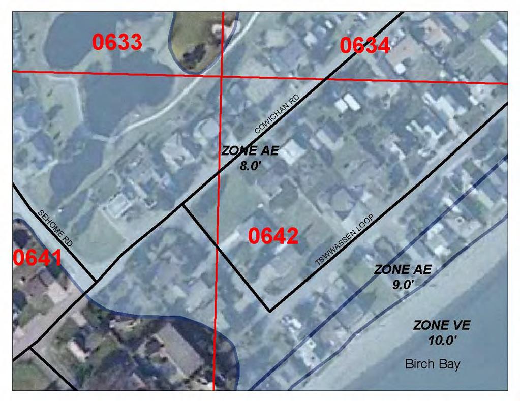
13 Appeal Period Area
14 Appeal Period Area
15 Appeal Period Area Flooding Source Description Affected Communities Black River Approximately 330 feet City of Renton City Tukwila downstream of Oaksdale Avenue Southwest to the confluence with Green River Cedar River At the upstream side of North Boeing Bridge to approximately 350 feet upstream of Landsburg Road Southeast City of Renton - Unincorporated Areas of King County Green River Kelsey Creek Mill Creek (Auburn) Mill Creek (Kent) Richards Creek Southwest 23 rd Street Drainage Channel Springbrook Creek West Tributary to Kelsey Creek Approximately 250 feet upstream of 42 nd Avenue South to approximately 1.8 miles upstream of Southeast Flaming Geyser Road At the upstream side of I-405 to the upstream side of Northeast 8 th Street Approximately 125 feet downstream of West Valley Highway to approximately 1,500 feet upstream of State Route 167 At the Springbrook Creek Confluence to approximately 133 feet downstream of East Smith Street At the confluence with Kelsey Creek to the approximately 752 feet upstream of Richards Road At the confluence with Springbrook Creek to Approximately 170 feet upstream of East Valley Road At the upstream side of the Black River Pump Station to approximately 0.32 miles upstream of South 228 th Street At confluence with Kelsey Creek to approximately 320 feet downstream of Northeast 1 st Street City of Auburn City of Kent City of Renton City of SeaTac City of Tukwila Muckleshoot Tribe Unincorporated Areas of King County City of Bellevue City of Auburn City of Kent Unincorporated Areas of King County City of Kent City of Bellevue City of Renton City of Kent City of Renton City of Bellevue

16 Why Modify our Current Approach? Throughout Map Modernization, stakeholders expressed concern on the without-levee procedures used to map non-accredited levees In February 2011, a group of U.S. Representatives and Senators wrote to FEMA requesting a revision to the current practice of mapping levees and their associated flood risk. Stakeholders and Congress felt the historical mapping approach did not reflect the hazard reduction that some non-accredited levees may still afford.

17 Levee Policy Process The King County Flood Insurance Study has been on hold as it waits for FEMA to finalize a new approach in showing floodplains on the landward side of levees that are not accredited to protect against the 1% flood.

18 Levee Policy Process FEMA has been introducing the new levee policy approach with a small number of pilot projects to understand the approach s impacts, benefits, allowing the agency to consideration its broader implementation. The Agency rolled-out the new levee policy approach in about 10% of the current on-hold studies, where communities were interested in moving forward with the new levee policy solution.
19 Levee Policy Process FEMA has been working since March 2011 to develop guidance for the new levee policy implementation on a national scale. The Agency will engage with the pilot project communities to: document the trial applications of the new levee policy, refine the standards and guidance for implementation, and prepare educational and training materials for future communities that will be engaged in the new levee policy.
20 Levee Policy Process Implement the new levee policy on a larger scale across the nation. The Agency is aware that the new levee policy approach requires more interaction between FEMA and the local communities and is committed to understanding the local knowledge and operation of a levee system prior to its determination of the appropriate new levee policy procedure(-s) King County was not chosen as one of the pilot studies. For more detail on the process, see: It is for these reasons that we do not have a timeframe for moving forward at this time but we will be sure to communicate this to all of the affected communities when this becomes known.
21 Seclusion Mapping Process This Process Allows: Historic investments of updated flood hazard analyses are able to be released on updated mapping Community officials, residents, and business owners are provided with more up to date flood hazard risk information On-hold projects (due to non-accredited levee) to move forward The Region reviews projects to determine applicability, works with community to verify they understand approach prior to its application


22 Seclusion Mapping Process Current Effective FIRM Depicted Study Findings Depicted Seclusion Boundary
23 Seclusion Mapping Process Inside the Levee Seclusion Area Flood hazards related to the levee system(s) will be defined as depicted on the current effective FIRM. Outside the Levee Seclusion Area Flood hazards may be modified and updated by the current revision and study efforts. A countywide database will be provided at preliminary and effective issuance for communities to review the flood hazards in their vicinity. Community officials should consult their current effective FIRM to determine the areas that have been modified.
 will be provided to aid community floodplain management enforcement and operations FEMA will return to analyze the flood risk in the vicinity of the levee at a future")
24 Seclusion Mapping Process Important items of note: Process is not applicable to all non-accredited levee systems This effort results in: Updated set of effective FIRMs for the community. Digital Data (DFIRM database) will be provided to aid community floodplain management enforcement and operations FEMA will return to analyze the flood risk in the vicinity of the levee at a future date Accreditation Status Change Analysis and Mapping Procedures for Non-Accredited Levees will be applied All levees in the nation will be addressed and updated
25 Seclusion criteria The levee has not been shown to meet 44 CFR The levee is hydraulically significant during the 1% flood, The levee has an owner, the levee meets the definition of a levee as spelled out in 44 CFR 59, and/or, the flood hazards on the river side of the levee will be updated with the most recent analysis in the flood study efforts.
26 Provisionally Accredited Levee (PAL)
27 Provisionally Accredited Levee (PAL) criteria Levee system needs to currently show accreditation by FEMA but the documentation needs updating A PAL is a process to provide a community seeking re-accredition of a levee system with additional time to submit the necessary documentation This process can only take place if the levee owner and a representative of each impacted community sign and return an enclosed agreement within 90 days of a letter to be sent shortly

28 Provisionally Accredited Levee (PAL) criteria Completion and submittal of the enclosed template will serve as your official request that FEMA label the levee as a Provisionally Accredited Levee (PAL) on the DFIRM and will serve as your agreement that, to the best of your knowledge, the levee meets the requirements of 44 CFR It is the responsibility of the levee owner to submit the data required by 44 CFR in order to certify the levee as providing protection from the base flood By endorsing the agreement, it acknowledges that if all necessary documentation to comply with 44 CFR is not provided in 2 years from the agreement start date, FEMA may initiate a map revision to re-designate certain areas on the landward side of the levee as flood-prone.

29 King County Levee Report

30 Levee Areas Evaluated

31 Levee Areas Evaluated

32 Levee Areas Evaluated

33 Levee Areas Evaluated

34 Levee Areas Evaluated
35 Post Preliminary Processing Timeline of events Preliminary maps issued... ~September 2016 Appeal Period ~Winter 2016/2017 End of Appeal Period.. FEMA issues Letter of Final Determination (LFD)... to communities and publishes the BFEs in the Federal Register Communities have 6 months to adopt the study before the data becomes effective. Failure to adopt results in suspension from NFIP Effective date... ~Spring 2017 ~Fall 2017 ~Spring 2018

36 King County Coastal Study
37 King County Coastal Study Timeline of events Preliminary maps issued... February 1, 2013 CCO Meeting... Public Meeting... Appeal Period Start Appeal Period End.. Letter of Final Determination.. Effective Date May 6 & 7, 2013 August 12, 2013 September 11, 2013 December 10, 2013 ~Fall 2017 ~Spring 2018

 14 river miles studied Prior data from 1978")
38 Sammamish River City of Bothell Floodplain Mapping Study Lake Sammamish to Lake Washington City of Kenmore City of Woodinville Unincorporated King County Study initiated to develop up-to-date and accurate floodplain analyses and to update FEMA s Digital Flood Insurance Rate Map (DFIRM) 14 river miles studied Prior data from 1978 City of Redmond

39 King County White River Study
40 Sammamish River/White River Study Timeline of events Preliminary maps issued... February 1, 2013 CCO Meeting... Public Meetings... Appeal Period Start Appeal Period End.. Letter of Final Determination.. Effective Date June 6, 2013 July 29, August 14, and August 21, 2013 September 11, 2013 December 10, 2013 ~Fall 2017 ~Spring 2018

41 Thornton Creek Watershed Study limited to the City of Seattle boundaries Extends from mouth at Lake Washington to Interstate 5 (Northgate area) Detailed study of Thornton Creek Mainstem, South Branch and North Branch (total of 6.8 miles) Approximate study of 5 tributaries: Littlebrook, Willow, Victory, Kramer, and Maple Creeks (total of ~ 1 mile)
42 Thornton Creek Study Timeline of events Preliminary maps issued... September 3, 2013 CCO Meeting... Public Meeting... Appeal Period Start Appeal Period End.. Letter of Final Determination.. Effective Date September 12, 2013 October 2, 2013 April 18, 2014 July 15, 2014 ~Fall 2017 ~Spring 2018
43 Questions & Comments FEMA: Flood Study Engineer: Ted Perkins (425) Risk Analyst/GIS Specialist: Kelly Stone (425) NFIP Insurance Specialist: Deb Gauthier (425) Floodplain Management Spec.: Karen Wood-McGuiness (425) Mitigation Planner: Brett Holt (425) WA DOE: Flood Study Coordinator Jerry Franklin (360) NFIP Coordinator David Radabaugh (425) STARR Project Manager: Carmen Burducea (301) Mark Seidelmann (614) Flood Insurance Information:
Skagit County Flood Insurance Study Update. Ryan Ike, CFM FEMA Region 10
 Skagit County Flood Insurance Study Update Ryan Ike, CFM FEMA Region 10 Skagit County Flood Insurance Study Process Overview Process, Schedule, & Deliverables Base Flood Elevations, Modeling, & Levees
CRISP COUNTY, GEORGIA AND INCORPORATED AREAS
 CRISP COUNTY, GEORGIA AND INCORPORATED AREAS Community Name Community Number ARABI, CITY OF 130514 CORDELE, CITY OF 130214 CRISP COUNTY (UNINCORPORATED AREAS) 130504 Crisp County EFFECTIVE: SEPTEMBER 25,
BUTTS COUNTY, GEORGIA AND INCORPORATED AREAS
 BUTTS COUNTY, GEORGIA AND INCORPORATED AREAS Butts County Community Name Community Number BUTTS COUNTY (UNICORPORATED AREAS) 130518 FLOVILLA, CITY OF 130283 JACKSON, CITY OF 130222 JENKINSBURG, TOWN OF
Updates to Maine Coastal Flood Insurance Rate Maps (FIRM s): What a Local Official Should Know. Presented by: Steve Johnson, P.E.
: What a Local Official Should Know. Presented by: Steve Johnson, P.E.") Updates to Maine Coastal Flood Insurance Rate Maps (FIRM s): What a Local Official Should Know Presented by: Steve Johnson, P.E. Town Engineer October 4, 2018 Introduction Federal Emergency Management
Updates to Maine Coastal Flood Insurance Rate Maps (FIRM s): What a Local Official Should Know Presented by: Steve Johnson, P.E. Town Engineer October 4, 2018 Introduction Federal Emergency Management
Using GISWeb to Determine Your Property s Flood Zone
 Using GISWeb to Determine Your Property s Flood Zone 1. In a new browser window, go to http://www.co.santacruz.ca.us/departments/geographicinformationsystemsgis.aspx 2. Click on GISWeb - GIS Mapping Application
Herkimer County, New York Flood Hazard Mapping Status Report for Property Owners
 Herkimer County, New York Flood Hazard Mapping Status Report for Property Owners Herkimer County, New York Flood Hazard Mapping Status Report for Property Owners FLOOD INSURANCE Who Should Purchase Flood
Federal Emergency Management Agency
 Page 1 of 5 Issue Date: October 16, 2014 Effective Date: March 2, 2015 Case No.: 14-09-2279P LOMR-APP Federal Emergency Management Agency Washington, D.C. 20472 LETTER OF MAP REVISION DETERMINATION DOCUMENT
Bucks County, PA Flood Risk Review Meeting. November 2014
 Bucks County, PA Flood Risk Review Meeting November 2014 Agenda for Today Risk MAP Program overview Overview of non-regulatory Flood Risk Products and datasets Discuss mitigation action Technical overview
Flood Risk Review (FRR) Meeting. Cumberland County, Pennsylvania Carlisle, Pennsylvania December 5, 2016
 Meeting. Cumberland County, Pennsylvania Carlisle, Pennsylvania December 5, 2016") Flood Risk Review (FRR) Meeting Cumberland County, Pennsylvania Carlisle, Pennsylvania December 5, 2016 Why are we here today? The Flood Insurance Study (FIS) report and Flood Insurance Rate Maps (FIRMs)
Flood Risk Review (FRR) Meeting Cumberland County, Pennsylvania Carlisle, Pennsylvania December 5, 2016 Why are we here today? The Flood Insurance Study (FIS) report and Flood Insurance Rate Maps (FIRMs)
MONROE COUNTY, GEORGIA
 MONROE COUNTY, GEORGIA AND INCORPORATED AREAS Monroe County Community Name Community Number *CULLODEN, CITY OF 130543 FORSYTH, CITY OF 130359 MONROE COUNTY 130138 (UNINCORPORATED AREAS) *No Flood Hazard
JAXGIS FEMA Flood Hazard Mapping -- Frequently Asked Questions
 Flood Hazard Zone Designations Summary Zones starting with the letter 'A' (for instance, Zone A, Zone AE, Zone AH, Zone AO) denote a Special Flood Hazard Area, which can also be thought of as the 100-year
Federal Emergency Management Agency
 Page 1 of 6 Issue Date: May 13 2016 Case No.: Follows Conditional Case No.: 14-05-0595R DETERMINATION DOCUMENT COMMUNITY AND REVISION INFORMATION PROECT DESCRIPTION BASIS OF REQUEST COMMUNITY Village of
Taylor County, Florida Community Coordination and Outreach (CCO) Meeting
 Meeting") Taylor County, Florida Community Coordination and Outreach (CCO) Meeting Suwannee River Water Management District April 26, 2017 11:00AM to 12:00PM Taylor County Administration Building, 201 E. Green Street,
Taylor County, Florida Community Coordination and Outreach (CCO) Meeting Suwannee River Water Management District April 26, 2017 11:00AM to 12:00PM Taylor County Administration Building, 201 E. Green Street,
Federal Emergency Management Agency
 Page 1 of 5 Issue Date: June 21, 2013 Follows Conditional Case No.: 04-06-A148R DETERMINATION DOCUMENT COMMUNITY COMMUNITY AND REVISION INFORMATION City of Irving Dallas County Texas FILL PROJECT DESCRIPTION
Federal Emergency Management Agency
 Page 1 of 5 Issue Date: April 2, 2015 DETERMINATION DOCUMENT COMMUNITY AND REVISION INFORMATION PROJECT DESCRIPTION BASIS OF REQUEST Ventura County California NO PROJECT UPDATE COMMUNITY (Unincorporated
DES MOINES COUNTY, IOWA AND INCORPORATED AREAS
 VOLUME 1 OF 1 DES MOINES COUNTY, IOWA AND INCORPORATED AREAS COMMUNITY NAME CID CITY OF BURLINGTON 190114 CITY OF DANVILLE 190115 DES MOINES COUNTY (UNINCORPORATED AREAS) 190113 CITY OF MEDIAPOLIS 190615
Understanding and Using NFIP Data
 Understanding and Using NFIP Data The understanding of those who provide information and of those who have to act responsibly in using that information is often very much misunderstood. Old Proverb Overview
Natchitoches Parish, Louisiana Flood Insurance Study Update Risk Analysis March 3, Shona Gibson Project Monitor, FEMA Region VI
 Natchitoches Parish, Louisiana Flood Insurance Study Update Risk Analysis Shona Gibson Project Monitor, FEMA Region VI Presentation Overview Introductions Why are we here? Levee Status and Opportunities
NFIP Mapping Issues. Wendy Lathrop, PLS, CFM. Cadastral Consulting, LLC
 NFIP Mapping Issues Cadastral Consulting, LLC NFIP Basic Objectives: Reduce the exposure to flood damages through the use of minimum standards for the placement and design of structures located in flood
Federal Emergency Management Agency
 Page 1 of 4 Issue Date: October 2, 2017 Effective Date: October 2, 2017 Case No.: 17-09-2731P LOMR-APP Federal Emergency Management Agency Washington, D.C. 20472 LETTER OF MAP REVISION DETERMINATION DOCUMENT
JENKINS COUNTY, GEORGIA
 JENKINS COUNTY, GEORGIA AND INCORPORATED AREAS Community Name Community Number Jenkins County JENKINS COUNTY 130118 (UNINCORPORATED AREAS) MILLEN, CITY OF 130119 Revised: August 5, 2010 FLOOD INSURANCE
VOLUME 1 OF 1 CARROLL COUNTY, IOWA AND INCORPORATED AREAS
 VOLUME 1 OF 1 CARROLL COUNTY, IOWA AND INCORPORATED AREAS COMMUNITY NAME NUMBER ARCADIA, CITY OF 190694 BREDA, CITY OF* 190926 CARROLL, CITY OF 190041 CARROLL COUNTY UNINCORPORATED AREAS 190039 COON RAPIDS,
Kentucky Risk MAP It s not Map Mod II
 Kentucky Risk MAP It s not Map Mod II Risk Mapping Assessment and Planning Carey Johnson Kentucky Division of Water carey.johnson@ky.gov What is Risk MAP? Risk Mapping, Assessment, and Planning (Risk MAP)
Durham County Preliminary Flood Hazard Data Public Meeting. July 28, 2016
 Durham County Preliminary Flood Hazard Data Public Meeting July 28, 2016 Why Are We Here New flood hazard data has been released as Preliminary for Durham County Statutory Due Process for review/comments
July 31, 2017 NFIP Flood Map Open House Flood Maps 101 Flood Mapping acronyms History of the NFIP Flood Mapping Updates Flood Insurance Fairhope,
 July 31, 2017 NFIP Flood Map Open House Flood Maps 101 Flood Mapping acronyms History of the NFIP Flood Mapping Updates Flood Insurance Fairhope, Alabama Flood Maps Fairhope Permitting Jurisdiction Coastal
DECATUR COUNTY, GEORGIA AND INCORPORATED AREAS
 DECATUR COUNTY, GEORGIA AND INCORPORATED AREAS Community Name Community Number ATTAPULGUS, CITY OF 130541 BAINBRIDGE, CITY OF 130204 BRINSON, TOWN OF 130670 CLIMAX, CITY OF 130542 DECATUR COUNTY (UNINCORPORATED
Community Coordination Meeting. York County, Maine. Risk MAP Study
 Community Coordination Meeting York County, Maine Risk MAP Study January 9, 2014 Agenda Welcome and Introductions Project Timeline Flood Hazard Analysis Recap (Digital Conversion, Riverine and Coastal)
Nassau County, Florida Consultation Coordination Officer (CCO) Meeting. February 24, 2016 Fernandina Beach, Florida
 Meeting. February 24, 2016 Fernandina Beach, Florida") Nassau County, Florida Consultation Coordination Officer (CCO) Meeting February 24, 2016 Fernandina Beach, Florida Agenda Introductions Coastal Study Update Study Process and Timeline Flood Insurance Implications
Nassau County, Florida Consultation Coordination Officer (CCO) Meeting February 24, 2016 Fernandina Beach, Florida Agenda Introductions Coastal Study Update Study Process and Timeline Flood Insurance Implications
Preliminary DFIRM Community Coordination (PDCC) Meeting Gilchrist & Levy Counties, FL. April 30, 2015
 Meeting Gilchrist & Levy Counties, FL. April 30, 2015") Preliminary DFIRM Community Coordination (PDCC) Meeting Gilchrist & Levy Counties, FL April 30, 2015 Agenda 1. Introductions 2. Study Process and Timeline 3. Overview of Preliminary Products 4. Overview
Preliminary DFIRM Community Coordination (PDCC) Meeting Gilchrist & Levy Counties, FL April 30, 2015 Agenda 1. Introductions 2. Study Process and Timeline 3. Overview of Preliminary Products 4. Overview
Federal Emergency Management Agency
 Page 1 of 6 Issue Date: September 27, 2010 Effective Date: February 14, 2011 Follows Conditional Case No.: 08-08-0873R DETERMINATION DOCUMENT COMMUNITY AND REVISION INFORMATION PROJECT DESCRIPTION BASIS
HOLMES COUNTY, FLORIDA AND INCORPORATED AREAS
 HOLMES COUNTY, FLORIDA AND INCORPORATED AREAS Community Name Community Number BONIFAY, CITY OF 120116 ESTO, TOWN OF 120630 HOLMES COUNTY (UNINCORPORATED AREAS) 120420 NOMA, TOWN OF 120631 PONCE DE LEON,
Federal Emergency Management Agency
 Page 1 of 5 Issue Date: July 27, 2012 Effective Date: December 10, 2012 Case No.: 11-06-4512P Follows Conditional Case No.: 06-06-B789R LOMR-APP Federal Emergency Management Agency Washington, D.C. 20472
PARK COUNTY, WYOMING AND INCORPORATED AREAS
 PARK COUNTY, WYOMING AND INCORPORATED AREAS Community Name Community Number CODY, CITY OF 560038 MEETEETSE, TOWN OF 560039 PARK COUNTY UNINCORPORATED AREAS 560085 POWELL, CITY OF 560040 June 18, 2010 Federal
Community Coordination Meeting Sagadahoc County, Maine
 Community Coordination Meeting Sagadahoc County, Maine Risk MAP Study April 2, 2014 Agenda Welcome and Introductions Project Timeline Flood Hazard Analysis Recap Flood Risk Products Action: Hazard Mitigation
Cameron County, TX. Consultation Coordination Officer (CCO) Meeting. Please sign in (sheet at front of the room) Meeting will begin at 9:00
 Meeting. Please sign in (sheet at front of the room) Meeting will begin at 9:00") Cameron County, TX Consultation Coordination Officer (CCO) Meeting Please sign in (sheet at front of the room) Meeting will begin at 9:00 July 29, 2015 Lisa Jennings FEMA Region 6 Roles & Responsibilities
Cameron County, TX Consultation Coordination Officer (CCO) Meeting Please sign in (sheet at front of the room) Meeting will begin at 9:00 July 29, 2015 Lisa Jennings FEMA Region 6 Roles & Responsibilities
SENECA COUNTY, OHIO AND INCORPORATED AREAS
 SENECA COUNTY, OHIO AND INCORPORATED AREAS COMMUNITY NAME COMMUNITY NUMBER ATTICA, VILLAGE OF* 390991 BETTSVILLE, VILLAGE OF 390500 BLOOMFIELD, VILLAGE OF* 390989 NEW RIEGEL, VILLAGE OF* 390990 REPUBLIC,
ENGINEERING REPORT FREEBOARD ANALYSIS. HOUSATONIC RIVER and NAUGATUCK RIVER FLOOD PROTECTION PROJECTS SECTION 1. ANSONIA and DERBY, CONNECTICUT
 ENGINEERING REPORT FREEBOARD ANALYSIS HOUSATONIC RIVER and NAUGATUCK RIVER FLOOD PROTECTION PROJECTS SECTION 1 ANSONIA and DERBY, CONNECTICUT December 2010 MMI #1560-119 and #3118-03 Prepared for: City
Floodplain Management 101. Mississippi Emergency Management Agency Floodplain Management Bureau
 Floodplain Management 101 Mississippi Emergency Management Agency Floodplain Management Bureau Stafford Act The Stafford Disaster Relief and Emergency Assistance Act (Stafford Act) (Public Law 100-707)
MEIGS COUNTY UNINCORPORATED AREAS
 VOLUME 1 MEIGS COUNTY, OHIO AND INCORPORATED AREAS COMMUNITY NAME COMMUNITY NUMBER MEIGS COUNTY UNINCORPORATED AREAS 390387 MIDDLEPORT, VILLAGE OF 390388 POMEROY, VILLAGE OF 390389 RACINE, VILLAGE OF 390390
Introduction to the National Flood Insurance Program: A Guide for Coastal Property Owners MAINE BEACHES CONFERENCE 2017
 Introduction to the National Flood Insurance Program: A Guide for Coastal Property Owners MAINE BEACHES CONFERENCE 2017 SUE BAKER, CFM STATE NFIP COORDINATOR MAINE DEPT OF AGRICULTURE, CONSERVATION & FORESTRY
Federal Emergency Management Agency
 Page 1 of 5 Issue Date: October 28, 2009 Follows Conditional Case No.: 08-08-0612R DETERMINATION DOCUMENT COMMUNITY AND REVISION INFORMATION PROJECT DESCRIPTION BASIS OF REQUEST COMMUNITY Lincoln County
CONWAY COUNTY, ARKANSAS AND INCORPORATED AREAS
 E VOLUME 1 OF 1 CONWAY COUNTY, ARKANSAS AND INCORPORATED AREAS COMMUNITY NAME CONWAY COUNTY, UNINCORPORATED AREAS COMMUNITY NUMBER 050426 MENIFEE, TOWN OF 050266 MORRILTON, CITY OF 050044 OPPELO, CITY
Table of Revisions for Appendix J,
 Table of Revisions for Appendix J, Format and Specifications for Flood Insurance Study Reports The following Summary of Changes details revisions of Appendix J subsequent to the initial publication of
Federal Emergency Management Agency
 Page 1 of 4 Issue Date: November 16 2016 Effective Date: March 31 2017 Case No: 16-06-2056P LOMR-APP Follows Conditional Case No: 10-06-3320R Federal Emergency Management Agency Washington DC 20472 LETTER
REVISED: MARCH 7, 2019 VOLUME 1 OF 3 MISSOULA COUNTY, MONTANA AND INCORPORATED AREAS COMMUNITY NUMBER COMMUNITY NAME
 VOLUME 1 OF 3 MISSOULA COUNTY, MONTANA AND INCORPORATED AREAS COMMUNITY NAME MISSOULA COUNTY, UNINCORPORATED AREAS COMMUNITY NUMBER 300048 MISSOULA, CITY OF 300049 REVISED: MARCH 7, 2019 FLOOD INSURANCE
JONES COUNTY GEORGIA AND INCORPORATED AREAS. Effective: May 4, 2009 FLOOD INSURANCE STUDY NUMBER 13169CV000A
 JONES COUNTY, GEORGIA AND INCORPORATED AREAS JONES COUNTY COMMUNITY NAME COMMUNITY NUMBER GRAY, CITY OF 130237 JONES COUNTY 130434 (UNINCORPORATED AREAS) Effective: May 4, 2009 FLOOD INSURANCE STUDY NUMBER
National Flood Insurance Program. Jennifer Gilbert, CFM, ANFI New Hampshire NFIP State Coordinator
 National Flood Insurance Program Jennifer Gilbert, CFM, ANFI New Hampshire NFIP State Coordinator What is the National Flood Insurance Program? Created by Congress in 1968 Participating Communities voluntarily
OTTAWA COUNTY AND SANDUSKY COUNTY COMMUNITY CONSULTATION OFFICERS (CCO) MEETING December 7, 2017
 MEETING December 7, 2017") OTTAWA COUNTY AND SANDUSKY COUNTY COMMUNITY CONSULTATION OFFICERS (CCO) MEETING December 7, 2017 TODAY S AGENDA The Value of Updated Flood Maps for Your Community Reviewing the Updated Flood Risk Data
OTTAWA COUNTY AND SANDUSKY COUNTY COMMUNITY CONSULTATION OFFICERS (CCO) MEETING December 7, 2017 TODAY S AGENDA The Value of Updated Flood Maps for Your Community Reviewing the Updated Flood Risk Data
Questions about the National Flood Insurance Program
 Questions about the National Flood Insurance Program Federal Emergency Management Agency (FEMA) Questions and Answers What is the National Flood Insurance Program (NFIP)? The NFIP is a Federal program
Pinellas County Flood Map Information Service & Real Estate Disclosure Program Training January 26, 2017 COMMON FLOODPLAIN ACRONYMS
 FEMA ASFPM BFE CAV Pinellas County Flood Map Information Service & Real Estate Disclosure Program Training COMMON FLOODPLAIN ACRONYMS Federal Emergency Management Agency Association of State Floodplain
Federal Emergency Management Agency
 Page 1 of 4 Issue Date: September 7, 2012 Effective Date: January 22, 2013 DETERMINATION DOCUMENT COMMUNITY COMMUNITY AND REVISION INFORMATION City of Lubbock Lubbock County Texas PROJECT DESCRIPTION CHANNELIZATION
Kevin Wagner Maryland Department of the Environment
 Kevin Wagner Maryland Department of the Environment Topics Overview of the National Flood Insurance Program (NFIP) Mapping Regulations Insurance Mitigation Community Rating System (CRS) Questions Know
WASHINGTON COUNTY, KENTUCKY AND INCORPORATED AREAS
 WASHINGTON COUNTY, KENTUCKY AND INCORPORATED AREAS COMMUNITY NAME COMMUNITY NUMBER *MACKVILLE, CITY OF 210475 SPRINGFIELD, CITY OF 210220 WASHINGTON COUNTY (UNINCORPORATED AREAS) 210365 *WILLISBURG, CITY
Georgia Flood M.A.P. Program Risk MAP Plenary Session GAFM 2011
 Georgia Flood M.A.P. Program Risk MAP Plenary Session GAFM 2011 Collis Brown, Georgia DNR March 24, 2011 GA Flood Map Modernization Responsible for end-to-end production Developed aggressive outreach program
LONG COUNTY, GEORGIA AND INCORPORATED AREAS. Long County. Effective: September 26, 2008 FLOOD INSURANCE STUDY NUMBER 13183CV000A
 LONG COUNTY, GEORGIA AND INCORPORATED AREAS Long County Community Name Community Number LONG COUNTY 130127 (UNINCORPORATED AREAS) LUDOWICI, CITY OF 130128 Effective: September 26, 2008 FLOOD INSURANCE
Federal Emergency Management Agency
 Page 1 of 6 Issue Date: October 24, 2012 Effective Date: March 7, 2013 Case No.: LOMR-APP DETERMINATION DOCUMENT COMMUNITY AND REVISION INFORMATION PROJECT DESCRIPTION BASIS OF REQUEST City of Lubbock
Cumberland County, NJ. Risk MAP Project Status Update April 22, 2013
 Cumberland County, NJ Risk MAP Project Status Update April 22, 2013 Agenda Project Team Milestones Risk MAP Overview Study Scope overview Regulatory products Non-regulatory products Proposed Schedule Risk
USACE Levee Safety Meeting FEMA Overview
 USACE Levee Safety Meeting FEMA Overview Christine Gaynes, CFM FEMA Region V Roger Denick, PE, CFM FEMA Region V Service Center Agenda FEMA Region V Overview FEMA Levee Program Levee Guidance Transformation
Federal Emergency Management Agency
 Page 1 of 4 Issue Date: August 1, 2012 Effective Date: December 13, 2012 Case No.: 12-06-0595P LOMR-APP Washington, D.C. 20472 LETTER OF MAP REVISION DETERMINATION DOCUMENT COMMUNITY AND REVISION INFORMATION
Analysis and Mapping Procedures for Non-Accredited Levees
 Analysis and Mapping Procedures for Non-Accredited Levees Proposed Approach for Public Review December 9, 2011 www.fema.gov/plan/prevent/fhm/rm_main.shtm 1 877 FEMA MAP Executive Summary Background This
Federal Emergency Management Agency
 Page 1 of 4 Issue Date: April 29, 2011 DETERMINATION DOCUMENT COMMUNITY COMMUNITY AND REVISION INFORMATION City of Simi Valley Ventura County California PROJECT DESCRIPTION NO PROJECT BASIS OF REQUEST
Federal Emergency Management Agency
 Page 1 of 4 Issue Date: April 26, 2013 DETERMINATION DOCUMENT COMMUNITY AND REVISION INFORMATION PROJECT DESCRIPTION BASIS OF REQUEST City of Coppell Dallas County Texas FILL HYDRAULIC ANALYSIS NEW TOPOGRAPHIC
Federal Emergency Management Agency
 Page 1 of 4 Issue Date: February 14, 2013 Effective Date: June 28, 2013 DETERMINATION DOCUMENT COMMUNITY AND REVISION INFORMATION City of Sunny Isles Beach Miami-Dade County Florida PROJECT DESCRIPTION
PUTNAM COUNTY, GEORGIA
 PUTNAM COUNTY, GEORGIA AND INCORPORATED AREAS Community Name Community Number Eatonton, City of 130218 Putnam County 130540 (Unincorporated Areas) Putnam County Effective: September 26, 2008 FLOOD INSURANCE
Requirements for Construction on Properties in the Special Flood Hazard Area (SFHA)
") Requirements for Construction on Properties in the Special Flood Hazard Area (SFHA) Rev 010915 The website for the IDNR to request the EFARA (Electronic Floodplain Analysis/Regulatory Assessment is found
Requirements for Construction on Properties in the Special Flood Hazard Area (SFHA) Rev 010915 The website for the IDNR to request the EFARA (Electronic Floodplain Analysis/Regulatory Assessment is found
Chemung HUC-8 Watershed Project. February 1, 2011
 Chemung HUC-8 Watershed Project Kickoff Bi Fl t NY Big Flats, NY February 1, 2011 Introductions FEMA Region II Alan Springett, Senior Engineer, FEMA Risk Analysis Risk Assessment Lead Robert Schaefer,
RichSmith_slate-FEMA_320x240.wmv.
 Nebraska DNR s role in the making of FEMA s Digital Flood Insurance Rate Maps Becky Groshens (grow-hands) & Shelley Schindler Important Terms: FIRM: Flood Insurance Rate Map FIS: Flood Insurance Study
Duval County, Florida Consultation Coordination Officer (CCO) Meeting. January 25, 2017 Jacksonville, Florida
 Meeting. January 25, 2017 Jacksonville, Florida") Duval County, Florida Consultation Coordination Officer (CCO) Meeting January 25, 2017 Jacksonville, Florida Agenda Introductions Coastal Study Update Study Process and Timeline Flood Insurance Implications
Duval County, Florida Consultation Coordination Officer (CCO) Meeting January 25, 2017 Jacksonville, Florida Agenda Introductions Coastal Study Update Study Process and Timeline Flood Insurance Implications
Community Officials Meeting. Plumas and Sierra County Physical Map Revision
 Community Officials Meeting Plumas and Sierra County Physical Map Revision March 6, 2014 Agenda Introductions/Sign In Project Scope Sierra Valley Flood Study (Plumas and Sierra Counties) North Yuba River
St. Johns County, Florida Consultation Coordination Officer (CCO) Meeting. August 31, 2016 St. Augustine, Florida
 Meeting. August 31, 2016 St. Augustine, Florida") St. Johns County, Florida Consultation Coordination Officer (CCO) Meeting August 31, 2016 St. Augustine, Florida Agenda Introductions Coastal Study Update Study Process and Timeline Flood Insurance Implications
St. Johns County, Florida Consultation Coordination Officer (CCO) Meeting August 31, 2016 St. Augustine, Florida Agenda Introductions Coastal Study Update Study Process and Timeline Flood Insurance Implications
INSTRUCTIONS FOR COMPLETING THE APPLICATION FORMS FOR CONDITIONAL LETTERS OF MAP REVISION AND LETTERS OF MAP REVISION
 INSTRUCTIONS FOR COMPLETING THE APPLICATION FORMS FOR CONDITIONAL LETTERS OF MAP REVISION AND LETTERS OF MAP REVISION GENERAL In 1968, the U.S. Congress passed the National Flood Insurance Act, which created
VOLUME 1 OF 1 GONZALES COUNTY, TEXAS AND INCORPORATED AREAS GONZALES COUNTY, UNINCORPORATED AREAS
 VOLUME 1 OF 1 GONZALES COUNTY, TEXAS AND INCORPORATED AREAS COMMUNITY NAME GONZALES COUNTY, UNINCORPORATED AREAS COMMUNITY NUMBER 480253 GONZALES, CITY OF 480254 NIXON, CITY OF 481114 SMILEY, CITY OF*
SECTION 9: MAPS AND DATA
 SECTION 9: MAPS AND DATA Contents 9.1. NFIP Maps and Data... 9-2 9.1.1. Adopting and enforcing NFIP floodplain maps and data... 9-2 9.1.2. Adopting and enforcing more restrictive data... 9-2 9.1.3. Annexations...
Discovery Report. Cache River Watershed, Alexander, Johnson, Pulaski, and Union Counties, Illinois
 Discovery Report Cache River Watershed, 07140108 Alexander, Johnson, Pulaski, and Union Counties, Illinois 12/21/2012 i Project Area Community List Community Name Alexander County Village of Tamms Johnson
VOLUME 1 OF 1 DALLAS COUNTY, TEXAS AND INCORPORATED AREAS
 VOLUME 1 OF 1 DALLAS COUNTY, TEXAS AND INCORPORATED AREAS COMMUNITY NAME NUMBER Lancaster, City of 480182 Lewisville, City of 480195 Mesquite, City of 485490 Ovilla, City of 481155 Richardson, City of
Bullitt County, Kentucky Preliminary DFIRM Community Open House. October 8, 2014 Shepherdsville, Kentucky
 Bullitt County, Kentucky Preliminary DFIRM Community Open House October 8, 2014 Shepherdsville, Kentucky Meeting Agenda Introductions Overview of Preliminary DFIRMs Overview of Map Appeal Process Questions
ASSUMPTION PARISH, LOUISIANA AND INCORPORATED AREAS
 VOLUME 1 of 1 ASSUMPTION PARISH, LOUISIANA AND INCORPORATED AREAS COMMUNITY NAME ASSUMPTION PARISH UNINCORPORATED AREAS COMMUNITY NUMBER 220017 NAPOLEONVILLE, TOWN OF 220018 REVISED PRELIMINARY November
Flood Map Revisions. Town of Nags Head Public Information and Input Session. December 14, 2016, 6 pm
 Flood Map Revisions Town of Nags Head Public Information and Input Session December 14, 2016, 6 pm Flood Map Revisions New preliminary flood maps released for Dare County June 30, 2016 www.nagsheadnc.gov/floodmaps
Non Regulatory Risk MAP Products Flood Depth and Probability Grids
 Non Regulatory Risk MAP Products Flood Depth and Probability Grids Virginia Floodplain Management Association 2015 Floodplain Management Workshop October 29th, 2015 Nabil Ghalayini, P.E., PMP, D.WRE, CFM
Federal Emergency Management Agency
 Page 1 of Issue Date: October 2 201 Effective Date: March 10 2017 Case No.: 1-08-0839P LOMR-APP Federal Emergency Management Agency Washington D.C. 2072 LETTER OF MAP REVISION DETERMINATION DOCUMENT COMMUNITY
Calhoun County Flood Insurance Study Update
 Calhoun County Flood Insurance Study Update Larry Voice FEMA Region VI September 18, 2009 AGENDA Introduction Study Overview and Status Update Levees Post-Preliminary Process Outreach Moving Forward 2
What Was Updated in 2004 in Hennepin Countywide Maps?
 What Was Updated in 2004 in Hennepin Countywide Maps? Combined the city and township maps into one countywide index Done by USACE Mainly digital capture of old floodplain boundaries; some spots with shifts
CONTRA COSTA COUNTY FLOODPLAIN MANAGEMENT PROGRAM
 CONTRA COSTA COUNTY FLOODPLAIN MANAGEMENT PROGRAM Answers to Commonly Asked Questions and A Guide for Residential Construction Within Special Flood Hazard Areas Revised February 2015 Introduction Ninety
Abington Township Public Meeting
 Abington Township Public Meeting Flood Insurance Rate Map Update March 23, 2016 1 Meeting Agenda and Format Provide residents/property owners of Abington Township with information about the map update,
EFFINGHAM COUNTY, GEORGIA
 EFFINGHAM COUNTY, GEORGIA AND INCORPORATED AREAS Effingham County COMMUNITY NAME COMMUNITY NUMBER EFFINGHAM COUNTY 130076 (UNINCORPORATED AREAS) GUYTON, CITY OF 130456 RINCON, CITY OF 130426 SPRINGFIELD,
King County Flood Control District Flood Risk Reduction Work Program and Accomplishments
 King County Flood Control District Flood Risk Reduction Work Program and Accomplishments Brian Murray Water and Land Resources Division April 26, 2016 Department of Natural Resources and Parks Water and
Agenda. Introduction. Introduction -Map Study Lifecycle. Insurance Benefits of New Map
 Agenda Introduction Effects of Map Changes on Flood Insurance Lower risk to higher risk ( Grandfathering ) Higher risk to lower risk ( Conversion ) No Change Vertical Datum change Summary Levees Levees
Enough about me! Topics Covered
 About Me Worked in land surveying since 1997 Employed by the City of Orlando since 2006 City of Orlando City Surveyor since February 2015 Certified Floodplain Manager since 2015 Florida Licensed Surveyor,
Federal Emergency Management Agency
 Page 1 of 5 Issue Date: October 19, 2012 Effective Date: March 4, 2013 Case No.: 12-06-3459P LOMR-APP Washington, D.C. 20472 LETTER OF MAP REVISION DETERMINATION DOCUMENT COMMUNITY AND REVISION INFORMATION
EMANUEL COUNTY, GEORGIA
 EMANUEL COUNTY, GEORGIA AND INCORPORATED AREAS Emanuel County COMMUNITY NAME COMMUNITY NUMBER *ADRIAN, CITY OF 130601 EMANUEL COUNTY 130307 (UNINCORPORATED AREAS) GARFIELD, CITY OF 130584 NUNEZ, TOWN OF
FOR LOCAL GOVERNMENTS
 FLOOD MAP OUTREACH PLANNING GUIDEBOOK FOR LOCAL GOVERNMENTS Version 1.1 Georgia Department of Natural Resources March 2010 Dear Community Official: Georgia s Department of Natural Resources (DNR) has partnered
GIS - Introduction and Sample Uses
 PDHonline Course L145 (5 PDH) GIS - Introduction and Sample Uses Instructor: Jonathan Terry, P.L.S. 2012 PDH Online PDH Center 5272 Meadow Estates Drive Fairfax, VA 22030-6658 Phone & Fax: 703-988-0088
Consultation Coordination Officer (CCO) Meeting
 Meeting") Consultation Coordination Officer (CCO) Meeting Middle Brazos Lake Whitney Physical Map Revision Hill and McLennan Counties FEMA Region 6 Agenda National Flood Insurance Program Purpose of the Meeting
Consultation Coordination Officer (CCO) Meeting Middle Brazos Lake Whitney Physical Map Revision Hill and McLennan Counties FEMA Region 6 Agenda National Flood Insurance Program Purpose of the Meeting
Erie County Flood Risk Review Meeting. January 18, 2018
 Erie County Flood Risk Review Meeting January 18, 2018 Agenda The value of updated flood maps for your community Review updated flood-risk data and important next steps in the Risk MAP process Increasing
AGENDA PLANNING ADVISORY BOARD SUBCOMMITTEE INDUSTRIAL STANDARDS FOR CONSTRUCTION WITHIN A FLOODPLAIN THURSDAY, AUGUST 25, :00-5:00 P.M.
 AGENDA PLANNING ADVISORY BOARD SUBCOMMITTEE INDUSTRIAL STANDARDS FOR CONSTRUCTION WITHIN A FLOODPLAIN THURSDAY, AUGUST 25, 2016 3:00-5:00 P.M. CITY COMMISSION CHAMBERS 204 ASH STREET FERNANDINA BEACH,
Federal Emergency Management Agency
 Federal Emergency Management Agency Washington, D.C. 20472 August 16, 2016 CERTIFIED MAIL IN REPLY REFER TO: RETURN RECEIPT REQUESTED Case No.: 16-07-1180P Community Name: City of Overland Park, KS The
Federal Emergency Management Agency
 Page 1 of 4 Issue Date: April 11, 2013 Case No.: DETERMINATION DOCUMENT COMMUNITY AND REVISION INFORMATION PROJECT DESCRIPTION BASIS OF REQUEST Town Of Stratford Fairfield County Connecticut NO PROJECT
Flood Hazard Risk Mapping:
 Mitigation Division Flood Hazard Risk Mapping: Past, Present and Future Oklahoma Floodplain Management Association Ron Wanhanen, PE FEMA Region 6 Risk Analysis Branch Overview The Past The Present Risk
Dealing With Unnumbered A Zones in Maine Floodplain Management
 Dealing With Unnumbered A Zones in Maine Floodplain Management The following is a list of acceptable methods that the State Floodplain Management Coordinator and the Federal Emergency Management Agency
FEDERAL INSURANCE AND MITIGATION ADMINISTRATION POLICY
 FEDERAL INSURANCE AND MITIGATION ADMINISTRATION POLICY I. TITLE: s for Flood Risk Analysis and Mapping II. DATE OF ISSUANCE: August 22, 2013 III. IV. POLICY STATEMENT: Flood risk projects, regulatory National