Federal Emergency Management Agency
|
|
|
- Erin Lyons
- 5 years ago
- Views:
Transcription
1 Federal Emergency Management Agency Washington, D.C August 16, 2016 CERTIFIED MAIL IN REPLY REFER TO: RETURN RECEIPT REQUESTED Case No.: P Community Name: City of Overland Park, KS The Honorable Carl Gerlach Community No.: Effective Date of Mayor, City of Overland Park 8500 Santa Fe Drive This Revision: January 4, 2017 Overland Park, KS Dear Mayor Gerlach: The Flood Insurance Rate Map for your community has been revised by this Letter of Map Revision (LOMR). Please use the enclosed annotated map panel revised by this LOMR for floodplain management purposes and for all flood insurance policies and renewals issued in your community. Additional documents are enclosed which provide information regarding this LOMR. Please see the List of Enclosures below to determine which documents are included. Other attachments specific to this request may be included as referenced in the Determination Document. If you have any questions regarding floodplain management regulations for your community or the National Flood Insurance Program (NFIP) in general, please contact the Consultation Coordination Officer for your community. If you have any technical questions regarding this LOMR, please contact the Director, Mitigation Division of the Department of Homeland Security's Federal Emergency Management Agency (FEMA) in Kansas City, Missouri, at (8 16) , or the FEMA Map Information exchange toll free at (l-877-fema MAP). Additional information about the NFIP is available on our website at Sincerely, Patrick "Rick" F. Sacbibt, P.E., Branch Chief Engineering Services Branch Federal Insurance and Mitigation Administration List of Enclosures: Letter of Map Revision Determination Document Annotated Flood Insurance Rate Map cc: Mr. Anthony Meyers, P.E. City of Overland Park Mr. Tony Rome, P.E. City of Overland Park Mr. Tom Morey, CFM Kansas Dept. of Agriculture Mr. Timothy Morgan HNTB Corporation
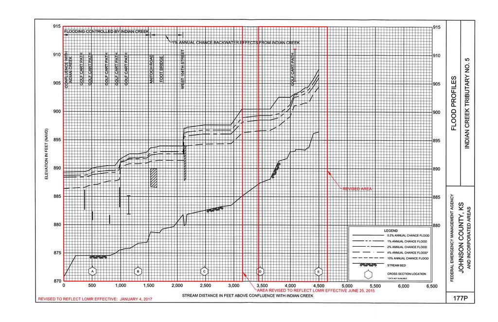
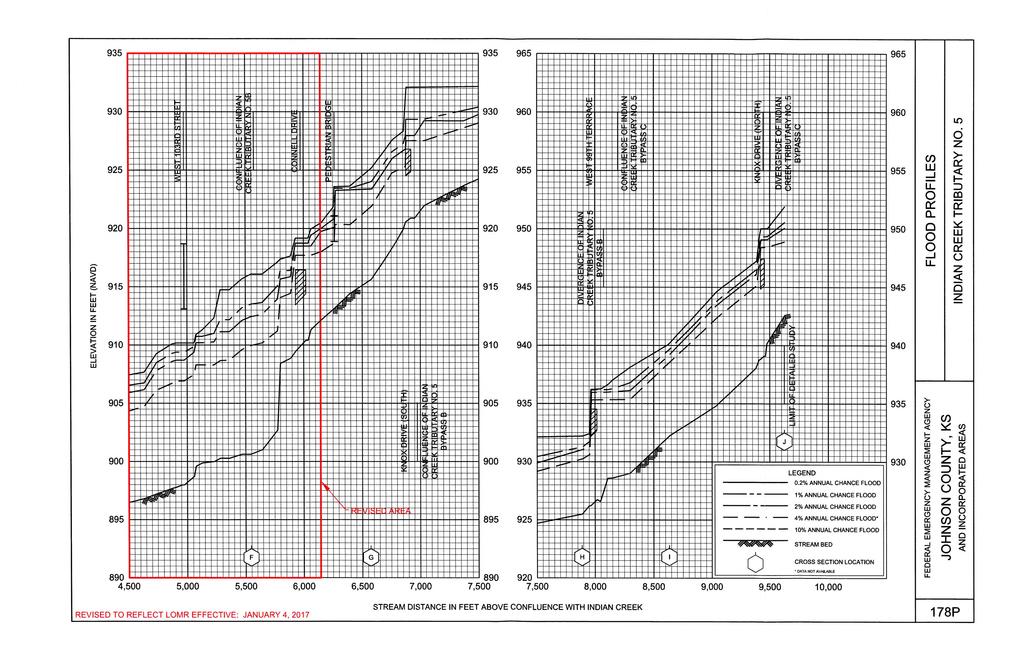
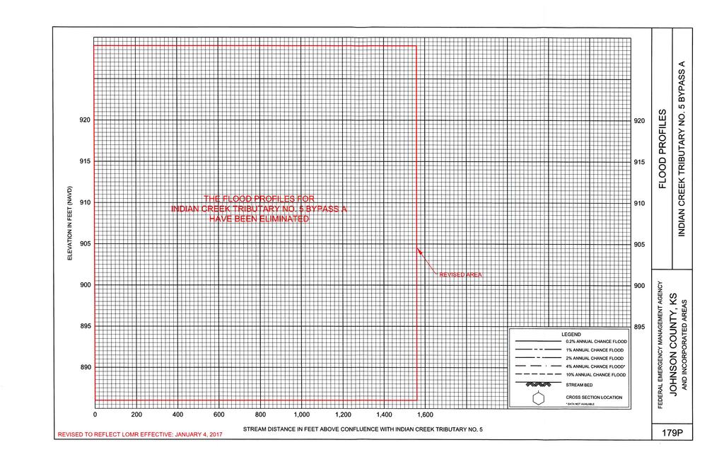
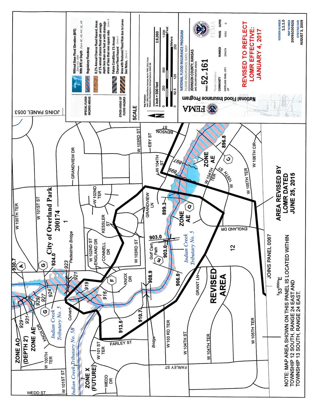
2 From Page 1 of 5 Issue Date: August 16, 2016 Effective Date: January 4, 2017 Case No.: P LOMR-APP Federal Emergency Management Agency Washington, D.C LETTER OF MAP REVISION DETERMINATION DOCUMENT COMMUNITY ANDREVISION FNFORMATION PROJECT DESCRIPTION BASISOF REQUEST COMMUNITY City Of Overland Park BRIDGE FLOODWAY Johnson County CHANNELIZATION HYDRAULIC ANALYSIS Kansas NEW TOPOGRAPHIC DATA COMMUNITY NO.: IDENTIFIER 103Rd and Connell Flood Control Project APPROXIMATE LATlTUDE& LONGITUDE: , SOURCE: USGS QUADRANGLE DATUM: NAD 83 ANNOTATED MAPPINGENCLOSURES ANNOTATED STUDYENCLOSURES TYPE: FlRM* NO.: 20091COO52G DATE: August 3, 2009 DATE OF EFFECTIVE FLOODINSURANCE STUDY: August 03, 2009 PROFILES: 177P, 178P, AND 179P FLOODWAY DATA TABLE: 6 Enclosures reflect changes to flooding sources affected by thisrevision. * Flood Insurance FIRM- Rate Map Indian Creek TributaryNo. 5 - FLOODINGSOURCE(S) & REVISED REACH(ES) See Page 2 for Additional Flooding Sources approximately 1,600 feet downstream of West 103rd Street to approximately200 feet upstream of Connell Drive. SUMMARY OF REVISIONS - Flooding Source Effective Flooding Revised Flooding Increases Decreases Indian Creek Tributary No. 5 Zone AE Zone AE NONE YES Zone X (unshaded) Zone X (unshaded) YES YES BFEs* BFEs YES YES Floodway Floodway NONE YES Zone AO Removed NONE YES BFEs Base Flood Elevations * DETERMINATION This document provides thedetermination from the Department of Homeland Security's Federal Emergency Management Agency (FEMA) regarding a request for a Letter of Map Revision (LOMR) for the area described above. Using the information submitted, we have determined that a revision to the flood hazards depicted in the Flood Insurance Study (FIS) report and/or National Flood Insurance Program (NFIP) map is warranted. This document revises the effective NF1P map, as indicated in the attached documentation. Please use the enclosed annotated map panels revised by this LOMR for floodplain management purposes and for all flood insurance policies and renewals in your community. This determination is based on the flood data presently available. The enclosed documents provide additionalinformation regarding thisdetermination. Ifyou have any questions about this document, please contact the FEMA Map Information exchange tollfree at (1-877-FEMA MAP)or by letter addressed to the LOMCClearinghouse, 847 South Pickett Street, Alexandria, VA Additional Information about the NFIP is available on our website at Patrick "Rick"F. Sacbibit, P E., Branch Chief Engineering Services Branch Federal insurance and Mitigation Administration P 102-l-A-C
3 Page 2 of 5 Issue Date: August 16, 2016 Effective Date: January 4, 2017 Case No.: P LOMR-APP Federal Emergency Management Agency Washington, D.C LETTER OF MAP REVISION DETERMINATION DOCUMENT (CONTINUED) OTHER FLOODING SOURCES AFFECTED BY THIS REVISION FLOODINGSOURCE(S) &REVISED REACH(ES) Indian Creek Tributary No. 5 Bypass A - Flooding source removed. SUMMARY OF REVISIONS Flooding Source Effective Flooding Revised Flooding Increases Decreases - Indian Creek Tributary No 5 Bypass A Zone X (unshaded) Zone X (unshaded) YES NONE Zone AE Removed NONE YES BFEs* Removed NONE YES Floodway Removed NONE YES BFEs Base Flood Elevations * This determination is based on the flood data presently available. The enclosed documents provide additionalinformation regarding this determination Ifyou have any questions about this document, please contact the FEMA Map Information exchange tollfree at (1-877-FEMA MAP) or by letter addressed to the LOMC Clearinghouse, 847 South Pickett Street Alexandria, VA AdditionalInformation about the NFIP is available on our website at Patrick 'Rick" F. Sacbibit, P.E., Branch Chief Engineering Services Branch Federal Insurance and Mitigation Administration P 102-l-A-C

4 Page 3 of 5 Issue Date: August 16, 2016 Effective Date: January 4, 2017 Case No.: P LOMR-APP. D $. Federal Emergency Management Agency Washington, D.C LETTER OF MAP REVISION DETERMINATION DOCUMENT (CONTINUED) COMMUNITY INFORMATION APPLICABLE NFIP REGULATIONS/COMMUNITY OBLIGATION We have made this determination pursuant to Section 206 of the Flood Disaster Protection Act of 1973 (P.L ) and in accordance with the National Flood Insurance Act of 1968, as amended (Title XIII of the Housing and Urban Development Act of 1968, P.L ), 42 U.S.C , and 44 CFR Part 65. Pursuant to Section 1361 of the National Flood Insurance Act of 1968, as amended, communities participating in the NFIP are required to adopt and enforce floodplain management regulations that meet or exceed NFIP criteria. These criteria, includingadoption of the FIS report and FIRM, and the modifications made by this LOMR, are the minimum requirements for continued NFIP participation and do not supersede more stringent State/Commonwealth or local requirements to which the regulations apply. We provide the floodway designation to your community as a tool to regulate floodplain development. Therefore, the floodway revision we have described in this letter, while acceptable to us, must also be acceptable to your community and adopted by appropriate community action, as specified in Paragraph 60.3(d) of the NFIP regulations. NFIP regulations Subparagraph 60.3(b)(7) requires communities to ensure that the flood-carrying capacity within the altered or relocated portion of any watercourse is maintained. This provision is incorporated into your community's existing floodplain management ordinances; therefore, responsibility for maintenance of the altered or relocated watercourse, including any related appurtenances such as bridges, culverts, and other drainagestructures, rests with your community. We may request that your community submit a description and schedule of maintenance activities necessary to ensure this requirement. COMMUNITY REMINDERS We based this determination on the 1-percent-annual-chance flood dischargescomputed in the FIS for your community without considering subsequent changes in watershed characteristics that could increase flood discharges. Future development of projects upstream could cause increased flood discharges,which could cause increased flood hazards. A comprehensive restudy of your community's flood hazards would consider the cumulative effects of development on flood discharges subsequent to the publication of the FIS report for your community and could, therefore, establish greater flood hazards in this area. Your community must regulate all proposed floodplain development and ensure that permits required by Federal and/or State/Commonwealth law have been obtained. State/Commonwealth or community officials, based on knowledge of local conditions and in the interest of safety, may set higher standards for construction or may limit development in floodplain areas. If your State/Commonwealth or community has adopted more restrictive or comprehensive floodplainmanagement criteria, those criteria take precedence over the minimum NFIP requirements. This determination is based on the flood data presently available. The enclosed documents provide additional information regarding this determination. If you have any questions aboutthis document, please contact the FEMA Map Information exchange tollfree at (1-877-FEMAMAP) or by letter addressed to the LOMCClearinghouse, 847 South Pickett Street, Alexandria,VA Additional Information aboutthe NFIP is available on our website at Patrick "Rick"F. Sacbibit, P.E Branch Chief, Engineering Serviœs Branch Federal Insurance and Mitigation Administration P 102-l-A-C
5 Page 4 of 5 Issue Date: August 16, 2016 Effective Date: January 4, 2017 Case No.: P LOMR-APP D Federal Emergency Management Agency Washington, D.C LETTER OF MAP REVISION DETERMINATION DOCUMENT (CONTINUED) We will not print and distribute this LOMR to primary users, such as local insurance agents or mortgage lenders; instead, the community will serve as a repository for the new data. We encourage you to disseminate the information in this LOMR by preparing a news release for publication in your community's newspaper that describes the revision and explains how your community will provide the data and help interpret the NFIP maps. In that way, interested persons, such as property owners, insurance agents, and mortgage lenders, can benefit from the information. We have designated a Consultation Coordination Officer (CCO) to assist your community. The CCO will be the primary liaison between your community and FEMA. For information regarding your CCO, please contact: Mr. Michael R. Scott Director, Mitigation Division Federal Emergency Management Agency, Region VII 9221 Ward Parkway, Suite 300 Kansas City, MO (816) STATUS OF THE COMMUNITY NFIP MAPS We will not physically revise and republish the FIRM and FlS report for your community to reflect the modifications made by this LOMR at this time. When changes to the previously cited FIRM panel(s) and FIS report warrant physical revision and republication in the future, we will incorporate the modifications made by this LOMR at that time. This determination is based on the flood data presently available. The enclosed documents provide additional information regarding this determination. If you have any questions aboutthis document, please contact the FEMAMap Information exchange tollfree at (1-877-FEMA MAP) or by letter addressed to the LOMCClearinghouse, 847 South Pickett Street, Alexandria, VA Additional Information aboutthe NFIP is available on our website at Patrick "Rick F. Sacbibit, P E., Branch Chief Engineering Services Branch Federal Insurance and Mitigation Administration P A-C
6 Page 5 of 5 Issue Date: August 16, 2016 Effective Date: January 4, 2017 Case No.: P LOMR-APP Federal Emergency Management Agency Washington, D.C LETTER OF MAP REVISION DETERMINATION DOCUMENT (CONTINUED) PUBLIC NOTIFICATION OF REVISION A notice of changes will be published in the Federal Register. This information also will be published in your local newspaper on or about the dates listed below, and through FEMA's Flood Hazard Mappingwebsite at status/bfe main.asp LOCAL NEWSPAPER Name: The Kansas City Star Dates: August 30, 2016 and September 6, 2016 Within 90 days of the second publication in the local newspaper, any interested party may request that we reconsider this determination. Any request for reconsideration must be based on scientific or technical data. Therefore, this letter will be effective only after the 90-day appeal period has elapsed and we have resolved any appeals that we receive during this appeal period. Until this LOMR is effective, the revised flood hazard determination presented in this LOMR may be changed. This determination is based on the flood data presently available. The enclosed documents provideadditional information regarding ttiis determination. If you have any questions about this document, please contact the FEMA Map Information exchange tollfree at (1-877-FEMAMAP) or by letter addressed to the LOMCClearinghouse, 847 South Pickett Street, Alexandria, VA Additional Information aboutthe NFIP is available on our website at fema.govlnfip. Patrick "Rick" F. Sacbibit, P.E., Branch Chief Engineering Services Branch Federal Insurance and Mitigation Administration P 102-l-A-C
7 FLOODING SOURCE.fl, RFVISFD TO RFFI FOT I OMR FFFFOTIVF JNF 25, 2015 FLOODWAY 1-PERCENT-ANNUAL-CHANCEFLOOD WATER SURFACE ELEVATION EXISTING EXIST1NG SECTION MEAN EXISTING FUTURE CONDITIONS CONDITIONS CROSS SECTION DISTANCE1 WlDTH AREA VELOCITY WITHOUT CONDITIONS CONDITIONS WITH INCREASE (FEET) (SQUARE (FEET PER (FEET NAVD) (FEET NAVD) FLOODWAY FLOODWAY (FEET) FEET) SECOND) (FEET (FEET NAVD88) NAVDSB) INDIANCREEK TRIR TARY NC) 5 gr A B 1, ' C D 3, , E 4, F G 6, H 7, \ I 8, J 9, Feet above confluene:e with Indian C eek "Elevation computedwithoutconsiderationof flooding controlledby Indian Creek REVlSED DATA m FEDERAL EMERGENCY MANAGEMENTAGENCY JOHNSON COUNTY, KS AND INCORPORATED AREAS FLOODWAY DATA INDIAN CREEK TRIBUTARY NO. 5 REVISED TO REFLECT LOMR EFFECTIVE: JANUARY 4, 2017
8 REVISED DATA 1-PERCENT-A FLOODING SOURCE MNUAL-CHANCEFLOOD FLOODWAY WATER SURFACE ELEVATION I EXISTING EXISTING SECTION MEAN EXISTING FUTURE CONDITIONS CONDITIONS CROSS SECTION DISTANCE1 WIDTH AREA VELOCITY CONDITIONS CONDITIONS WITHOUT WITH INCREASE (FEET) (SQUARE (FEET PER (FEET NAVD) (FEET NAVD) FLOODWAY FLOODWAY (FEET) FEET) SECOND) (FEET (FEET NAVD88) NAVDS8) INDIANCREEK TRIBUTARYNO. 5 BYPASS B A B C , INDIANCREEK TRIBUTARYNO. 5 BYPASS C A B C 1, D 1, Feet above confluence with Indian C eek Tributarl No. 5 FEDERAL EMERGENCY MANAGEMENTAGENCY JOHNSON COUNTY, KS AND INCORPORATED AREAs REVISED TO REFLECT LOMR EFFECTIVE: JANUARY 4, 2017 FLOODWAY DATA - INDIAN CREEK TRIBUTARY NO. 5 BYPASS B CREEK TRIBUTARY NO. 5 BYPASS C REVISED DAl \ INDIAN
9
10
11
12
Federal Emergency Management Agency
 Page 1 of 5 Issue Date: July 27, 2012 Effective Date: December 10, 2012 Case No.: 11-06-4512P Follows Conditional Case No.: 06-06-B789R LOMR-APP Federal Emergency Management Agency Washington, D.C. 20472
Federal Emergency Management Agency
 Page 1 of 5 Issue Date: October 16, 2014 Effective Date: March 2, 2015 Case No.: 14-09-2279P LOMR-APP Federal Emergency Management Agency Washington, D.C. 20472 LETTER OF MAP REVISION DETERMINATION DOCUMENT
Federal Emergency Management Agency
 Page 1 of 4 Issue Date: October 2, 2017 Effective Date: October 2, 2017 Case No.: 17-09-2731P LOMR-APP Federal Emergency Management Agency Washington, D.C. 20472 LETTER OF MAP REVISION DETERMINATION DOCUMENT
Federal Emergency Management Agency
 Page 1 of 4 Issue Date: August 1, 2012 Effective Date: December 13, 2012 Case No.: 12-06-0595P LOMR-APP Washington, D.C. 20472 LETTER OF MAP REVISION DETERMINATION DOCUMENT COMMUNITY AND REVISION INFORMATION
Federal Emergency Management Agency
 Page 1 of 4 Issue Date: April 11, 2013 Case No.: DETERMINATION DOCUMENT COMMUNITY AND REVISION INFORMATION PROJECT DESCRIPTION BASIS OF REQUEST Town Of Stratford Fairfield County Connecticut NO PROJECT
Federal Emergency Management Agency
 Page 1 of 5 Issue Date: October 28, 2009 Follows Conditional Case No.: 08-08-0612R DETERMINATION DOCUMENT COMMUNITY AND REVISION INFORMATION PROJECT DESCRIPTION BASIS OF REQUEST COMMUNITY Lincoln County
Federal Emergency Management Agency
 Page 1 of 4 Issue Date: September 7, 2012 Effective Date: January 22, 2013 DETERMINATION DOCUMENT COMMUNITY COMMUNITY AND REVISION INFORMATION City of Lubbock Lubbock County Texas PROJECT DESCRIPTION CHANNELIZATION
Federal Emergency Management Agency
 Page 1 of 6 Issue Date: September 27, 2010 Effective Date: February 14, 2011 Follows Conditional Case No.: 08-08-0873R DETERMINATION DOCUMENT COMMUNITY AND REVISION INFORMATION PROJECT DESCRIPTION BASIS
Federal Emergency Management Agency
 Page 1 of 5 Issue Date: April 2, 2015 DETERMINATION DOCUMENT COMMUNITY AND REVISION INFORMATION PROJECT DESCRIPTION BASIS OF REQUEST Ventura County California NO PROJECT UPDATE COMMUNITY (Unincorporated
Federal Emergency Management Agency
 Federal Emergency Management Agency Washington, D. C. 24 72 December 29, 214 CERTIFIED MAIL RETURN RECEIPT REQUESTED The Honorable Gary Wescott Mayor, City of Stevens Point 1515 Strongs A venue Stevens
Federal Emergency Management Agency
 Page 1 of 6 Issue Date: October 24, 2012 Effective Date: March 7, 2013 Case No.: LOMR-APP DETERMINATION DOCUMENT COMMUNITY AND REVISION INFORMATION PROJECT DESCRIPTION BASIS OF REQUEST City of Lubbock
Federal Emergency Management Agency
 Page 1 of 4 Issue Date: April 26, 2013 DETERMINATION DOCUMENT COMMUNITY AND REVISION INFORMATION PROJECT DESCRIPTION BASIS OF REQUEST City of Coppell Dallas County Texas FILL HYDRAULIC ANALYSIS NEW TOPOGRAPHIC
Federal Emergency Management Agency
 Page 1 of 6 Issue Date: May 13 2016 Case No.: Follows Conditional Case No.: 14-05-0595R DETERMINATION DOCUMENT COMMUNITY AND REVISION INFORMATION PROECT DESCRIPTION BASIS OF REQUEST COMMUNITY Village of
Federal Emergency Management Agency
 Page 1 of 5 Issue Date: June 21, 2013 Follows Conditional Case No.: 04-06-A148R DETERMINATION DOCUMENT COMMUNITY COMMUNITY AND REVISION INFORMATION City of Irving Dallas County Texas FILL PROJECT DESCRIPTION
l ederal Emergency Management Agency
 past.it ~[.~hn 014 854 482 l ederal Emergency Management Agency August 16, 2011 CERTIFIED MAIL RETURN RECEIPT REQUESTED The Honorable Frank Mann Chairman, Lee County Board of Commissioners Post Office
Federal Emergency Management Agency
 Page 1 of 4 Issue Date: November 16 2016 Effective Date: March 31 2017 Case No: 16-06-2056P LOMR-APP Follows Conditional Case No: 10-06-3320R Federal Emergency Management Agency Washington DC 20472 LETTER
Federal Emergency Management Agency
 Page 1 of 4 Issue Date: February 14, 2013 Effective Date: June 28, 2013 DETERMINATION DOCUMENT COMMUNITY AND REVISION INFORMATION City of Sunny Isles Beach Miami-Dade County Florida PROJECT DESCRIPTION
Federal Emergency Management Agency
 Page 1 of 5 Issue Date: October 19, 2012 Effective Date: March 4, 2013 Case No.: 12-06-3459P LOMR-APP Washington, D.C. 20472 LETTER OF MAP REVISION DETERMINATION DOCUMENT COMMUNITY AND REVISION INFORMATION
Federal Emergency Management Agency
 Page 1 of 4 Issue Date: April 29, 2011 DETERMINATION DOCUMENT COMMUNITY COMMUNITY AND REVISION INFORMATION City of Simi Valley Ventura County California PROJECT DESCRIPTION NO PROJECT BASIS OF REQUEST
Federal Emergency Management Agency
 Page 1 of 4 Issue ate: May 18, 2012 Follows Conditional Case No.: 08-06-1597R ETERMINATION OCUMENT COMMUNITY AN REVISION INFORMATION PROJECT ESCRIPTION BASIS OF REQUEST COMMUNITY Harris County Texas (Unincorporated
Federal Emergency Management Agency
 age 1 of 4 Issue Date: April 16, 2013 Effective Date: August 30, 2013 DETERMINATION DOCUMENT COMMUNITY AND REVISION INFORMATION ROJECT DESCRITION BASIS OF REQUEST City of Naples Collier County Florida
Federal Emergency Management Agency
 Page 1 of Issue Date: October 2 201 Effective Date: March 10 2017 Case No.: 1-08-0839P LOMR-APP Federal Emergency Management Agency Washington D.C. 2072 LETTER OF MAP REVISION DETERMINATION DOCUMENT COMMUNITY
Federal Emergency Management Agency
 Page 1 of 4 Issue ate: January 16, 2013 Effective ate: May 30, 2013 ETERMINATION OCUMENT COMMUNITY COMMUNITY AN REVISION INFORMATION City of Lawton Comanche County Oklahoma BRIGE CULVERT PROJECT ESCRIPTION
If you have any questions or concerns please give us a call at , or Walter Jenkins at (ext 300).
.") FLORIDA ZONE SERVICES Flood Insurance and Zone Consulting 461 SE 3 rd Terrace Pompano Beach, FL 33060 Phone 954-290-7420 bspencer@florida-floodzone.com March 6, 2014 Dear Pebblebrook II Homeowner: We informing
FLORIDA ZONE SERVICES Flood Insurance and Zone Consulting 461 SE 3 rd Terrace Pompano Beach, FL 33060 Phone 954-290-7420 bspencer@florida-floodzone.com March 6, 2014 Dear Pebblebrook II Homeowner: We informing
Federal Emergency Management Agency
 Page 1 of 5 Issue Date: May 14, 2013 Effective Date: September 25, 2013 Case No.: 13-06-1508P LOMR-APP Washington, D.C. 20472 LETTER OF MAP REVISION DETERMINATION DOCUMENT COMMUNITY AND REVISION INFORMATION
Federal Emergency Management Agency. Washington, D.C August 14,2014
 August 14,2014 CERTIFIED MAIL RETURN RECEIPT REQUESTED The Honorable Greg Chilcott Chairman, Ravalli County Board of Commissioners 215 South 4th Street, Suite A Hamilton, MT 59840 IN REPLY REFER TO: Case
Federal Emergency Management Agency
 Page 1 of 4 Date: January 27, 2015 COMMUNITY AND MAP PANEL INFORMATION COMMUNITY CITY OF FARGO, CASS COUNTY, LEGAL PROPERTY DESCRIPTION Lots 28, 32, 42 and 43, Block 2, Lot 9, Block 8, Legacy I Fourth,
Federal Emergency Management Agency
 Page 1 of 4 Issue Date: May 28, 21 Effective Date: May 28, 21 Follows Conditional Case o.: Case o.: 9-9-241P 7-9-557R ington, D.C. 2472 LETTER OF MAP REVISIO DETERMIATIO DOCUMET COMMUITY AD REVISIO IFORMATIO
Federal Emergency Management Agency
 Page 1 of 4 Issue ate: January 16, 2013 Effective ate: May 30, 2013 Case No.: 11-06-3317P LOMR-APP Washington,.C. 20472 LETTER OF MAP REVISION ETERMINATION OCUMENT COMMUNITY AN REVISION INFORMATION PROJECT
CRISP COUNTY, GEORGIA AND INCORPORATED AREAS
 CRISP COUNTY, GEORGIA AND INCORPORATED AREAS Community Name Community Number ARABI, CITY OF 130514 CORDELE, CITY OF 130214 CRISP COUNTY (UNINCORPORATED AREAS) 130504 Crisp County EFFECTIVE: SEPTEMBER 25,
Federal Emergency Management Agency
 Page 1 of 5 Issue ate: November 19 2013 ffective ate: April 2 2014 Case No.: Washington.C. 20472 TMINATION OCUMNT COMMUNITY AN VISION INFOMATION POJCT SCIPTION BASIS OF QUST Town of Fishkill utchess County
Federal Emergency Management Agency
 Page 1 of 5 Issue ate: July 6, 216 ffective ate: July 6, 216 Case No.: 16-2-154P LOM-APP Federal mergency Management Agency Washington,.C. 2472 LTT OF MAP VISION TMINATION OCUMNT AN VISION INFOMATION POJCT
Durham County Preliminary Flood Hazard Data Public Meeting. July 28, 2016
 Durham County Preliminary Flood Hazard Data Public Meeting July 28, 2016 Why Are We Here New flood hazard data has been released as Preliminary for Durham County Statutory Due Process for review/comments
Taylor County, Florida Community Coordination and Outreach (CCO) Meeting
 Meeting") Taylor County, Florida Community Coordination and Outreach (CCO) Meeting Suwannee River Water Management District April 26, 2017 11:00AM to 12:00PM Taylor County Administration Building, 201 E. Green Street,
Taylor County, Florida Community Coordination and Outreach (CCO) Meeting Suwannee River Water Management District April 26, 2017 11:00AM to 12:00PM Taylor County Administration Building, 201 E. Green Street,
INSTRUCTIONS FOR COMPLETING THE APPLICATION FORMS FOR CONDITIONAL LETTERS OF MAP REVISION AND LETTERS OF MAP REVISION
 INSTRUCTIONS FOR COMPLETING THE APPLICATION FORMS FOR CONDITIONAL LETTERS OF MAP REVISION AND LETTERS OF MAP REVISION GENERAL In 1968, the U.S. Congress passed the National Flood Insurance Act, which created
Herkimer County, New York Flood Hazard Mapping Status Report for Property Owners
 Herkimer County, New York Flood Hazard Mapping Status Report for Property Owners Herkimer County, New York Flood Hazard Mapping Status Report for Property Owners FLOOD INSURANCE Who Should Purchase Flood
Federal Emergency Management Agency
 Page 1 of 3 COMMUNITY AND MAP PANEL INFORMATION COMMUNITY CITY OF MARGATE CITY, ATLANTIC COUNTY, NEW JERSEY LEGAL PROPERTY DESCRIPTION A parcel of land, as described in Deed recorded in Book 4826, page
Federal Emergency Management Agency
 Page 1 of 5 Issue ate: November 19 213 ffective ate: April 2 214 Case No.: Federal mergency Management Agency Washington.C. 2472 LTT OF MAP VISION TMINATION OCUMNT COMMUNITY AN VISION INFOMATION POJCT
SECTION 9: MAPS AND DATA
 SECTION 9: MAPS AND DATA Contents 9.1. NFIP Maps and Data... 9-2 9.1.1. Adopting and enforcing NFIP floodplain maps and data... 9-2 9.1.2. Adopting and enforcing more restrictive data... 9-2 9.1.3. Annexations...
Requirements for Construction on Properties in the Special Flood Hazard Area (SFHA)
") Requirements for Construction on Properties in the Special Flood Hazard Area (SFHA) Rev 010915 The website for the IDNR to request the EFARA (Electronic Floodplain Analysis/Regulatory Assessment is found
Requirements for Construction on Properties in the Special Flood Hazard Area (SFHA) Rev 010915 The website for the IDNR to request the EFARA (Electronic Floodplain Analysis/Regulatory Assessment is found
THE FEDERAL EMERGENCY MANAGEMENT AGENCY. Letters of Map Change Kristen Martinenza, P.E., CFM FEMA Region IV
 THE FEDERAL EMERGENCY MANAGEMENT AGENCY Letters of Map Change Presented by: Kristen Martinenza, P.E., CFM FEMA Region IV 1 NATIONAL FLOOD INSURANCE ACT OF 1968 At the start of the program, there was not
Nassau County, Florida Consultation Coordination Officer (CCO) Meeting. February 24, 2016 Fernandina Beach, Florida
 Meeting. February 24, 2016 Fernandina Beach, Florida") Nassau County, Florida Consultation Coordination Officer (CCO) Meeting February 24, 2016 Fernandina Beach, Florida Agenda Introductions Coastal Study Update Study Process and Timeline Flood Insurance Implications
Nassau County, Florida Consultation Coordination Officer (CCO) Meeting February 24, 2016 Fernandina Beach, Florida Agenda Introductions Coastal Study Update Study Process and Timeline Flood Insurance Implications
Table 1: Federal, State and Local Government Rules applicable to LOMRs/CLOMRS submittal
 MnDNR LOMC Guide This document has been prepared by the Minnesota Department of Natural Resources floodplain staff and is intended to provide assistance with LOMR/CLOMR submittals. This information is
Preliminary DFIRM Community Coordination (PDCC) Meeting Gilchrist & Levy Counties, FL. April 30, 2015
 Meeting Gilchrist & Levy Counties, FL. April 30, 2015") Preliminary DFIRM Community Coordination (PDCC) Meeting Gilchrist & Levy Counties, FL April 30, 2015 Agenda 1. Introductions 2. Study Process and Timeline 3. Overview of Preliminary Products 4. Overview
Preliminary DFIRM Community Coordination (PDCC) Meeting Gilchrist & Levy Counties, FL April 30, 2015 Agenda 1. Introductions 2. Study Process and Timeline 3. Overview of Preliminary Products 4. Overview
St. Johns County, Florida Consultation Coordination Officer (CCO) Meeting. August 31, 2016 St. Augustine, Florida
 Meeting. August 31, 2016 St. Augustine, Florida") St. Johns County, Florida Consultation Coordination Officer (CCO) Meeting August 31, 2016 St. Augustine, Florida Agenda Introductions Coastal Study Update Study Process and Timeline Flood Insurance Implications
St. Johns County, Florida Consultation Coordination Officer (CCO) Meeting August 31, 2016 St. Augustine, Florida Agenda Introductions Coastal Study Update Study Process and Timeline Flood Insurance Implications
NFIP Mapping Issues. Wendy Lathrop, PLS, CFM. Cadastral Consulting, LLC
 NFIP Mapping Issues Cadastral Consulting, LLC NFIP Basic Objectives: Reduce the exposure to flood damages through the use of minimum standards for the placement and design of structures located in flood
Floodplain Management 101: UNIT II. Maps & Flood Insurance Studies
 Floodplain Management 101: UNIT II Maps & Flood Insurance Studies Who is ASFPM? ASFPM stands for the Association of State Floodplain Managers A national organization of floodplain management professionals
PARK COUNTY, WYOMING AND INCORPORATED AREAS
 PARK COUNTY, WYOMING AND INCORPORATED AREAS Community Name Community Number CODY, CITY OF 560038 MEETEETSE, TOWN OF 560039 PARK COUNTY UNINCORPORATED AREAS 560085 POWELL, CITY OF 560040 June 18, 2010 Federal
INSTRUCTIONS FOR COMPLETING THE APPLICATION FORMS FOR CONDITIONAL LETTERS OF MAP REVISION AND LETTERS OF MAP REVISION
 INSTRUCTIONS FOR COMPLETING THE APPLICATION FORMS FOR CONDITIONAL LETTERS OF MAP REVISION AND LETTERS OF MAP REVISION GENERAL In 1968, the U.S. Congress passed the National Flood Insurance Act, which created
BUTTS COUNTY, GEORGIA AND INCORPORATED AREAS
 BUTTS COUNTY, GEORGIA AND INCORPORATED AREAS Butts County Community Name Community Number BUTTS COUNTY (UNICORPORATED AREAS) 130518 FLOVILLA, CITY OF 130283 JACKSON, CITY OF 130222 JENKINSBURG, TOWN OF
LOCAL OFFICIALS MEETING Lake Wausau Physical Map Revision MARATHON COUNTY, WISCONSIN FEBRUARY 9, 2017
 LOCAL OFFICIALS MEETING Lake Wausau Physical Map Revision MARATHON COUNTY, WISCONSIN FEBRUARY 9, 2017 Welcome & Introduction Michelle Staff Floodplain Management Policy Coordinator, WDNR Michelle.Staff@Wisconsin.gov
King County, WA DFIRM Update and Seclusion Process. Webinar June 14, 2016
 King County, WA DFIRM Update and Seclusion Process Webinar June 14, 2016 Agenda King County DFIRM Study History What is/has been done Process for moving forward Seclusion Seclusion mapping process Seclusion
Community Coordination Meeting. York County, Maine. Risk MAP Study
 Community Coordination Meeting York County, Maine Risk MAP Study January 9, 2014 Agenda Welcome and Introductions Project Timeline Flood Hazard Analysis Recap (Digital Conversion, Riverine and Coastal)
If you have any questions or concerns please give us a call at , or Walter Jenkins at (ext 300).
.") FLORIDA FLOODZONE SERVICES Flood Insurance and Zone Consulting 461 SE 3 rd Terrace Pompano Beach, FL 33060 Phone 954-290-7420 bspencer@florida-floodzone.com March 15, 2010 Dear Portofino Lakes Homeowner:
FLORIDA FLOODZONE SERVICES Flood Insurance and Zone Consulting 461 SE 3 rd Terrace Pompano Beach, FL 33060 Phone 954-290-7420 bspencer@florida-floodzone.com March 15, 2010 Dear Portofino Lakes Homeowner:
Appendix D - Floodplain Documents
 City of Aspen Urban Runoff Management Plan Appendix D - Floodplain Documents 1. Floodplain Development Permit 2. Elevation Certificate and Instructions 3. Floodproofing Certificate for Non-Residential
DECATUR COUNTY, GEORGIA AND INCORPORATED AREAS
 DECATUR COUNTY, GEORGIA AND INCORPORATED AREAS Community Name Community Number ATTAPULGUS, CITY OF 130541 BAINBRIDGE, CITY OF 130204 BRINSON, TOWN OF 130670 CLIMAX, CITY OF 130542 DECATUR COUNTY (UNINCORPORATED
VOLUME 1 OF 1 CARROLL COUNTY, IOWA AND INCORPORATED AREAS
 VOLUME 1 OF 1 CARROLL COUNTY, IOWA AND INCORPORATED AREAS COMMUNITY NAME NUMBER ARCADIA, CITY OF 190694 BREDA, CITY OF* 190926 CARROLL, CITY OF 190041 CARROLL COUNTY UNINCORPORATED AREAS 190039 COON RAPIDS,
MONROE COUNTY, GEORGIA
 MONROE COUNTY, GEORGIA AND INCORPORATED AREAS Monroe County Community Name Community Number *CULLODEN, CITY OF 130543 FORSYTH, CITY OF 130359 MONROE COUNTY 130138 (UNINCORPORATED AREAS) *No Flood Hazard
Dealing With Unnumbered A Zones in Maine Floodplain Management
 Dealing With Unnumbered A Zones in Maine Floodplain Management The following is a list of acceptable methods that the State Floodplain Management Coordinator and the Federal Emergency Management Agency
Updates to Maine Coastal Flood Insurance Rate Maps (FIRM s): What a Local Official Should Know. Presented by: Steve Johnson, P.E.
: What a Local Official Should Know. Presented by: Steve Johnson, P.E.") Updates to Maine Coastal Flood Insurance Rate Maps (FIRM s): What a Local Official Should Know Presented by: Steve Johnson, P.E. Town Engineer October 4, 2018 Introduction Federal Emergency Management
Updates to Maine Coastal Flood Insurance Rate Maps (FIRM s): What a Local Official Should Know Presented by: Steve Johnson, P.E. Town Engineer October 4, 2018 Introduction Federal Emergency Management
Community Coordination Meeting Sagadahoc County, Maine
 Community Coordination Meeting Sagadahoc County, Maine Risk MAP Study April 2, 2014 Agenda Welcome and Introductions Project Timeline Flood Hazard Analysis Recap Flood Risk Products Action: Hazard Mitigation
9/20/2016. Orange County Preliminary FIRM / Consultation Coordination Officer (CCO) Meeting
 Meeting") Orange County Preliminary FIRM / Consultation Coordination Officer (CCO) Meeting Open Pacific Coast Study September 21 and 22, 2016 1 Welcome and Introductions Preliminary FIRM / CCO Meeting Orange County
Orange County Preliminary FIRM / Consultation Coordination Officer (CCO) Meeting Open Pacific Coast Study September 21 and 22, 2016 1 Welcome and Introductions Preliminary FIRM / CCO Meeting Orange County
Duval County, Florida Consultation Coordination Officer (CCO) Meeting. January 25, 2017 Jacksonville, Florida
 Meeting. January 25, 2017 Jacksonville, Florida") Duval County, Florida Consultation Coordination Officer (CCO) Meeting January 25, 2017 Jacksonville, Florida Agenda Introductions Coastal Study Update Study Process and Timeline Flood Insurance Implications
Duval County, Florida Consultation Coordination Officer (CCO) Meeting January 25, 2017 Jacksonville, Florida Agenda Introductions Coastal Study Update Study Process and Timeline Flood Insurance Implications
National Flood Insurance Program (NFIP) for Real Estate Professionals
 for Real Estate Professionals") National Flood Insurance Program (NFIP) for Real Estate Professionals 1 Joshua Oyer, CFM Outreach Specialist NFIP State Coordinator s Office at the Texas Water Development Board 2 Outline Introduction
National Flood Insurance Program (NFIP) for Real Estate Professionals 1 Joshua Oyer, CFM Outreach Specialist NFIP State Coordinator s Office at the Texas Water Development Board 2 Outline Introduction
Skagit County Flood Insurance Study Update. Ryan Ike, CFM FEMA Region 10
 Skagit County Flood Insurance Study Update Ryan Ike, CFM FEMA Region 10 Skagit County Flood Insurance Study Process Overview Process, Schedule, & Deliverables Base Flood Elevations, Modeling, & Levees
Flood Risk Review (FRR) Meeting. Cumberland County, Pennsylvania Carlisle, Pennsylvania December 5, 2016
 Meeting. Cumberland County, Pennsylvania Carlisle, Pennsylvania December 5, 2016") Flood Risk Review (FRR) Meeting Cumberland County, Pennsylvania Carlisle, Pennsylvania December 5, 2016 Why are we here today? The Flood Insurance Study (FIS) report and Flood Insurance Rate Maps (FIRMs)
Flood Risk Review (FRR) Meeting Cumberland County, Pennsylvania Carlisle, Pennsylvania December 5, 2016 Why are we here today? The Flood Insurance Study (FIS) report and Flood Insurance Rate Maps (FIRMs)
Pre-Development Floodplain Application
 Pre-Development Floodplain Application The Department of Planning, at the recommendation of FEMA, is now requiring completion of a Pre- Development Floodplain Application for all properties in the regulated
FREQUENTLY ASKED QUESTION ABOUT FLOODPLAINS Michigan Department of Environmental Quality
 FREQUENTLY ASKED QUESTION ABOUT FLOODPLAINS Michigan Department of Environmental Quality WHAT IS A FLOOD? The National Flood Insurance Program defines a flood as a general and temporary condition of partial
North Carolina Department of Public Safety Emergency Management Risk Management
 North Carolina Department of Public Safety Emergency Management Risk Management Roy Cooper, Governor Erik A. Hooks, Secretary Michael A. Sprayberry, Director INSTRUCTIONS FOR COMPLETING THE NORTH CAROLINA
PROPOSED ORDINANCE AMENDMENT SUMMARY
 PROPOSED ORDINANCE AMENDMENT SUMMARY DATE: March 14,2012 ORDINANCES TO BE AMENDED: Walworth County Code of Ordinances; Shoreland Zoning SECTIONS OF THE ORDINANCE TO BE AMENDED: 74-264 PROPOSED HEARING
MEIGS COUNTY UNINCORPORATED AREAS
 VOLUME 1 MEIGS COUNTY, OHIO AND INCORPORATED AREAS COMMUNITY NAME COMMUNITY NUMBER MEIGS COUNTY UNINCORPORATED AREAS 390387 MIDDLEPORT, VILLAGE OF 390388 POMEROY, VILLAGE OF 390389 RACINE, VILLAGE OF 390390
THE $64,000 FLOOD INSURANCE BILL
 THE $64,000 FLOOD INSURANCE BILL GEORGIA ASSOCIATION OF FLOODPLAIN MANAGERS 9 TH ANNUAL TECHNICAL CONFERENCE Patrick Gervais, PE, CFM A CASE STUDY IN FLOOD INSURANCE This is a true story that happened
VOLUME 1 OF 1 GONZALES COUNTY, TEXAS AND INCORPORATED AREAS GONZALES COUNTY, UNINCORPORATED AREAS
 VOLUME 1 OF 1 GONZALES COUNTY, TEXAS AND INCORPORATED AREAS COMMUNITY NAME GONZALES COUNTY, UNINCORPORATED AREAS COMMUNITY NUMBER 480253 GONZALES, CITY OF 480254 NIXON, CITY OF 481114 SMILEY, CITY OF*
PUTNAM COUNTY, GEORGIA
 PUTNAM COUNTY, GEORGIA AND INCORPORATED AREAS Community Name Community Number Eatonton, City of 130218 Putnam County 130540 (Unincorporated Areas) Putnam County Effective: September 26, 2008 FLOOD INSURANCE
Floodplain Management 101. Mississippi Emergency Management Agency Floodplain Management Bureau
 Floodplain Management 101 Mississippi Emergency Management Agency Floodplain Management Bureau Stafford Act The Stafford Disaster Relief and Emergency Assistance Act (Stafford Act) (Public Law 100-707)
SENECA COUNTY, OHIO AND INCORPORATED AREAS
 SENECA COUNTY, OHIO AND INCORPORATED AREAS COMMUNITY NAME COMMUNITY NUMBER ATTICA, VILLAGE OF* 390991 BETTSVILLE, VILLAGE OF 390500 BLOOMFIELD, VILLAGE OF* 390989 NEW RIEGEL, VILLAGE OF* 390990 REPUBLIC,
Technical Memorandum 3.4 E Avenue NW Watershed Drainage Study. Appendix E Floodplain Impacts and Implications Memo
 Technical Memorandum 3.4 E Avenue NW Watershed Drainage Study Appendix E Floodplain Impacts and Implications Memo September 8, 2017 City of Cedar Rapids E Avenue Watershed Drainage Study Memo Date: Tuesday,
JENKINS COUNTY, GEORGIA
 JENKINS COUNTY, GEORGIA AND INCORPORATED AREAS Community Name Community Number Jenkins County JENKINS COUNTY 130118 (UNINCORPORATED AREAS) MILLEN, CITY OF 130119 Revised: August 5, 2010 FLOOD INSURANCE
Questions about the National Flood Insurance Program
 Questions about the National Flood Insurance Program Federal Emergency Management Agency (FEMA) Questions and Answers What is the National Flood Insurance Program (NFIP)? The NFIP is a Federal program
Bullitt County, Kentucky Preliminary DFIRM Community Open House. October 8, 2014 Shepherdsville, Kentucky
 Bullitt County, Kentucky Preliminary DFIRM Community Open House October 8, 2014 Shepherdsville, Kentucky Meeting Agenda Introductions Overview of Preliminary DFIRMs Overview of Map Appeal Process Questions
NFIP Overview Elevation Certificate Flood Insurance Rate Maps. By: Maureen O Shea, AICP, CFM State NFIP Coordinator
 NFIP Overview Elevation Certificate Flood Insurance Rate Maps By: Maureen O Shea, AICP, CFM State NFIP Coordinator Example of a flood failure Example of a flood failure Purposes of the NFIP Identify &
JONES COUNTY GEORGIA AND INCORPORATED AREAS. Effective: May 4, 2009 FLOOD INSURANCE STUDY NUMBER 13169CV000A
 JONES COUNTY, GEORGIA AND INCORPORATED AREAS JONES COUNTY COMMUNITY NAME COMMUNITY NUMBER GRAY, CITY OF 130237 JONES COUNTY 130434 (UNINCORPORATED AREAS) Effective: May 4, 2009 FLOOD INSURANCE STUDY NUMBER
Bucks County, PA Flood Risk Review Meeting. November 2014
 Bucks County, PA Flood Risk Review Meeting November 2014 Agenda for Today Risk MAP Program overview Overview of non-regulatory Flood Risk Products and datasets Discuss mitigation action Technical overview
JAXGIS FEMA Flood Hazard Mapping -- Frequently Asked Questions
 Flood Hazard Zone Designations Summary Zones starting with the letter 'A' (for instance, Zone A, Zone AE, Zone AH, Zone AO) denote a Special Flood Hazard Area, which can also be thought of as the 100-year
Abington Township Public Meeting
 Abington Township Public Meeting Flood Insurance Rate Map Update March 23, 2016 1 Meeting Agenda and Format Provide residents/property owners of Abington Township with information about the map update,
OTTAWA COUNTY AND SANDUSKY COUNTY COMMUNITY CONSULTATION OFFICERS (CCO) MEETING December 7, 2017
 MEETING December 7, 2017") OTTAWA COUNTY AND SANDUSKY COUNTY COMMUNITY CONSULTATION OFFICERS (CCO) MEETING December 7, 2017 TODAY S AGENDA The Value of Updated Flood Maps for Your Community Reviewing the Updated Flood Risk Data
OTTAWA COUNTY AND SANDUSKY COUNTY COMMUNITY CONSULTATION OFFICERS (CCO) MEETING December 7, 2017 TODAY S AGENDA The Value of Updated Flood Maps for Your Community Reviewing the Updated Flood Risk Data
DES MOINES COUNTY, IOWA AND INCORPORATED AREAS
 VOLUME 1 OF 1 DES MOINES COUNTY, IOWA AND INCORPORATED AREAS COMMUNITY NAME CID CITY OF BURLINGTON 190114 CITY OF DANVILLE 190115 DES MOINES COUNTY (UNINCORPORATED AREAS) 190113 CITY OF MEDIAPOLIS 190615
National Flood Insurance Program. Jennifer Gilbert, CFM, ANFI New Hampshire NFIP State Coordinator
 National Flood Insurance Program Jennifer Gilbert, CFM, ANFI New Hampshire NFIP State Coordinator What is the National Flood Insurance Program? Created by Congress in 1968 Participating Communities voluntarily
Door County Floodplain Program Informational Meeting
 Door County Floodplain Program Informational Meeting Door County Land Use Services Department Wisconsin Department of Natural Resources January 15, 2018 Floodplain = Land affected by flood event with a
Chapter 5 Floodplain Management
 Chapter 5 Floodplain Management Contents 1.0 Introduction... 1 2.0 Floodplain Management and Regulation... 1 2.1 City Code... 1 2.2 Floodplain Management... 1 2.3 Level of Flood Protection... 2 2.3.1 Standard
July 31, 2017 NFIP Flood Map Open House Flood Maps 101 Flood Mapping acronyms History of the NFIP Flood Mapping Updates Flood Insurance Fairhope,
 July 31, 2017 NFIP Flood Map Open House Flood Maps 101 Flood Mapping acronyms History of the NFIP Flood Mapping Updates Flood Insurance Fairhope, Alabama Flood Maps Fairhope Permitting Jurisdiction Coastal
Table of Revisions for Appendix J,
 Table of Revisions for Appendix J, Format and Specifications for Flood Insurance Study Reports The following Summary of Changes details revisions of Appendix J subsequent to the initial publication of
Martin County, Florida Consultation Coordination Officer (CCO) Meeting. March 22, 2018 Stuart, Florida
 Meeting. March 22, 2018 Stuart, Florida") Martin County, Florida Consultation Coordination Officer (CCO) Meeting March 22, 2018 Stuart, Florida Agenda Introductions Coastal Flood Risk Study Review Data Collected Storm Surge Modeling Overland Wave
Martin County, Florida Consultation Coordination Officer (CCO) Meeting March 22, 2018 Stuart, Florida Agenda Introductions Coastal Flood Risk Study Review Data Collected Storm Surge Modeling Overland Wave
Floodplain Development Permit Application
 Floodplain Development Permit Application **All construction will also require a building permit** This is an application packet for a Floodplain Development Permit. Certain sections are to be completed
HOLMES COUNTY, FLORIDA AND INCORPORATED AREAS
 HOLMES COUNTY, FLORIDA AND INCORPORATED AREAS Community Name Community Number BONIFAY, CITY OF 120116 ESTO, TOWN OF 120630 HOLMES COUNTY (UNINCORPORATED AREAS) 120420 NOMA, TOWN OF 120631 PONCE DE LEON,
EFFINGHAM COUNTY, GEORGIA
 EFFINGHAM COUNTY, GEORGIA AND INCORPORATED AREAS Effingham County COMMUNITY NAME COMMUNITY NUMBER EFFINGHAM COUNTY 130076 (UNINCORPORATED AREAS) GUYTON, CITY OF 130456 RINCON, CITY OF 130426 SPRINGFIELD,
Enough about me! Topics Covered
 About Me Worked in land surveying since 1997 Employed by the City of Orlando since 2006 City of Orlando City Surveyor since February 2015 Certified Floodplain Manager since 2015 Florida Licensed Surveyor,
Using GISWeb to Determine Your Property s Flood Zone
 Using GISWeb to Determine Your Property s Flood Zone 1. In a new browser window, go to http://www.co.santacruz.ca.us/departments/geographicinformationsystemsgis.aspx 2. Click on GISWeb - GIS Mapping Application
LONG COUNTY, GEORGIA AND INCORPORATED AREAS. Long County. Effective: September 26, 2008 FLOOD INSURANCE STUDY NUMBER 13183CV000A
 LONG COUNTY, GEORGIA AND INCORPORATED AREAS Long County Community Name Community Number LONG COUNTY 130127 (UNINCORPORATED AREAS) LUDOWICI, CITY OF 130128 Effective: September 26, 2008 FLOOD INSURANCE
Article 23-6 FLOODPLAIN DISTRICT
 AMENDING THE CODE OF THE CITY OF PITTSFIELD CHAPTER 23, ZONING ORDINANCE SECTION I That the Code of the City of Pittsfield, Chapter 23, Article 23-6 Floodplain District, shall be replaced with the following: