July 31, 2017 NFIP Flood Map Open House Flood Maps 101 Flood Mapping acronyms History of the NFIP Flood Mapping Updates Flood Insurance Fairhope,
|
|
|
- Rosa Jackson
- 6 years ago
- Views:
Transcription
1 July 31, 2017 NFIP Flood Map Open House Flood Maps 101 Flood Mapping acronyms History of the NFIP Flood Mapping Updates Flood Insurance Fairhope, Alabama Flood Maps Fairhope Permitting Jurisdiction Coastal Map Changes Inland Map Changes Public review and comment period Further Information Questions?
2 Flood Maps 101
3 Flood Zone terminology and acronyms NFIP- National Flood Insurance Program BFE- Base Flood Elevation is anticipated flood elevation measured in feet above Mean Sea Level. CAV- Community Assistance Visit FIRM- Flood Insurance Rate Map SFHA- Special Flood Hazard Areas are commonly referred to as flood zones (AE, VE, Floodway, Etc) Floodway- riverine channel or watercourse that carries high velocity flood waters AE Zone- area determined to be in the 100 year floodplain with potential flooding caused by rising water. VE Zone- area determined to be in the 100 year floodplain with potential flooding caused by rising water and subject to wave action. X Zone- area determined to be outside the 500 year floodplain. Shaded X Zone- area determined to be outside the 100 year floodplain but within the 500 year floodplain with rising water generally 1 or less. LOMA/ LOMR- Letter of Map Amendment or Letter of Map Revision Freeboard- additional clearance above the BFE required by local ordinance.
4 History of the National Flood Insurance Program (NFIP) Created by Congress in 1968 by the National Flood Insurance Act Purpose was to address specific flood hazards in communities throughout the country by creating regulations for construction and building elevation in known flood hazard areas. Specific requirements for flood insurance program and construction standards are in 44 CFR (Code of Federal Regulations), Section 60.3 NFIP participation voluntary Community must adopt a Flood Damage Prevention Ordinance meeting at least the minimum requirements in 44 CFR and enforce construction and elevation requirements. Insurance Discounts are available by enforcing requirements above the minimums listed in 44 CFR, Section 60.3 Communities are rated based on an Audit (Community Assistance Visit) Community Insurance Rates based on score determined by CAV Individuals cannot opt-out of NFIP construction requirements
5 Flood Mapping Updates At various intervals, FEMA provides funding for flood studies and mapping updates to reflect current flood hazards within a community FEMA s Mapping, Assessment, and Planning (MAP) Program (goals) Implement watershed-based studies that create a more accurate, holistic picture of risk. Ensure 80% of nation s flood hazards are current Maximize the number of communities that use Risk MAP data to develop, implement, or update their hazard mitigation plans Deliver accurate flood data that leads to actions that reduce risk to life and property. Current Effective maps dated July 7, 2007 FEMA/ Alabama Office of Water Resources coordinating agencies AMEC Foster Wheeler coordinating engineering consultant Coordination with Northwest Florida Water Management District

6 Flood Mapping Updates Detailed Studies Zone AE Zone AE 214 miles of studies Zone VE 111 miles of studies Approximate Studies Zone A 494 miles of studies
7 Flood Mapping Updates Data Collection Aerial imagery LiDAR ground surface elevation data Field survey data Effective FEMA studies and existing engineering studies Develop Riverine Hydrology USGS Regression Equations USGS Gage Data Rainfall-Runoff Model Effective Flows
8 Elevation (ft) Flood Mapping Updates Riverine Hydraulic Modeling Cross section geometry developed from LiDAR, field survey, and leverage model geometry Hydraulic structure data developed from field survey Manning s n roughness coefficients developed from review of field investigation and aerial imagery Ineffective flow areas and expansion/contraction coefficients based on topography (Floodplain geometry) Flows from hydrologic studies Water surface profiles are computed Flint Creek Plan: Multiple Profiles_Floodway 7/29/2015 Interpolated based on UPS-DS Survey inverts, FTC390XS Legend WS P100yr Crit P100yr Ground Ineff Bank Sta Station (ft)
9 Flood Insurance Flood Insurance is a federally backed insurance program that is part of the National Flood Insurance Program providing insurance coverage from flood damage to homes and businesses. You do not have to live in a flood zone to purchase flood insurance. Flood damage is typically not covered by a standard homeowners insurance policy. Flood Insurance can cover up to $250,000 for structural and $100,000 in contents for residential policy holders. Coverages for businesses are up to $500,000 for both structure and contents. The terms Flood and Water Damage refer to separate things on most insurance policies. Buildings and insurance rates are rated as Pre-FIRM and Post-FIRM. Flood Insurance is significantly different from Disaster Assistance Between 60-80% of flood losses occur outside SFHA
10 Fairhope, Alabama Flood Maps
11

12
13
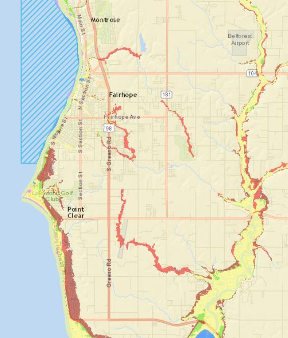
14 Coastal Map Changes Generally, most Coastal High Hazard zones (VE Zones) pushed further out to water and often changed to AE Zones on land (Point Clear, Montrose, Bayfront areas) Most Bayfront flood zones North of Bailey s Creek had decreases in BFE or remained same as 2007 maps Increases in BFE generally start at Bailey s Creek and carry South to County Road 1 Shaded Zone X created along East side of Scenic Hwy 98
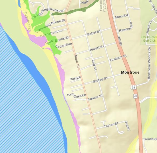
15 Montrose

16 North Fairhope- Bluff area

17 Fairhope- Fruit and Nut area

18 Point Clear- Battles Wharf area

19 Point Clear- Grand Hotel area
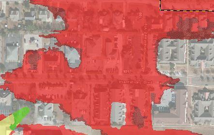
20 Inland Map Changes Cowpen Creek and several un-named creeks mapped for the first time West of Greeno Road- South of Middle St to Twin Beech Rd Affects several existing subdivisions: Spring Lake River Oaks /D Estrehan Fairfield Place Hawthorne Glen Song Grove Fly Creek outfall at Mobile Bay (Fly Creek Marina) Outfall at Fly Creek Marina changed from AE to VE Zone Seacliff Drive Woodlands Plantation Pines
21 Inland Map Changes Un-named creek at Quail Creek North Entrance to River Oaks Bunker Loop Portions of Falls Creek Waterhole Branch (Fairhope Airport) Significant map changes to inland creek beds Have not historically been mapped, were included in 2017 riverine study


22 Fairhope- Fly Creek new riverine AE zone

23 Fairhope- Cowpen Creek and Tributaries
24 Public Comment and Review Period
25 Review Process Per Fairhope Flood Damage Prevention Ordinance, these maps are in effect as they are considered best available data Maps are considered Preliminary under FEMA adoption process. Review and Comment period will take approximately 12 months. During review period, anyone who disagrees with map determinations may undertake the LOMA/ LOMR process to amend the maps. Burden of proof is on the individual challenging the map determination All existing LOMAs/ LOMRs are voided if map is more restrictive. Public meetings will be held at various locations and intervals. Meeting dates and times will be announced at they are made known
26 Fairhope Floodplain Enforcement Revision and update of Flood Damage Prevention Ordinance Fairhope to join the Community Ratings System (CRS) in 2018 Code-plus enforcement of floodplain regulations allows for across the board flood insurance discounts for all Fairhope residents Elevation Certificates required for all flood zone construction Total of 3 certificates required for new construction Fairhope Ordinance requires 1 freeboard for all flood zones Measured to interior floor in AE zone Measured to lowest structural member in VE zones
27 Additional Information and Resources
28 Additional Resources and Information Alabama Office of Water Resources (OWR) flood maps (preliminary map data dated 7/25/2017) FEMA flood maps online (current effective maps dated 7/7/2007) FEMA National Flood Insurance Program FEMA Letter of Map Amendment / Letter of Map Revision information City of Fairhope Building Department (updates to begin September 18, 2017)


29 Alabama Office of Water Resources Map Tips for using OWR website: Website address is You can toggle and change the view from the current maps to the new, preliminary maps on the Legend on the right hand side. Preliminary Data is the new mapping information dated July 2017 Regulatory Effective is the current map information dated July 2007
30 Contact Information City of Fairhope Building Department Erik Cortinas, CBO, LEED AP Building Official (251)
THE $64,000 FLOOD INSURANCE BILL
 THE $64,000 FLOOD INSURANCE BILL GEORGIA ASSOCIATION OF FLOODPLAIN MANAGERS 9 TH ANNUAL TECHNICAL CONFERENCE Patrick Gervais, PE, CFM A CASE STUDY IN FLOOD INSURANCE This is a true story that happened
Floodplain Management 101. Mississippi Emergency Management Agency Floodplain Management Bureau
 Floodplain Management 101 Mississippi Emergency Management Agency Floodplain Management Bureau Stafford Act The Stafford Disaster Relief and Emergency Assistance Act (Stafford Act) (Public Law 100-707)
Durham County Preliminary Flood Hazard Data Public Meeting. July 28, 2016
 Durham County Preliminary Flood Hazard Data Public Meeting July 28, 2016 Why Are We Here New flood hazard data has been released as Preliminary for Durham County Statutory Due Process for review/comments
Bucks County, PA Flood Risk Review Meeting. November 2014
 Bucks County, PA Flood Risk Review Meeting November 2014 Agenda for Today Risk MAP Program overview Overview of non-regulatory Flood Risk Products and datasets Discuss mitigation action Technical overview
Door County Floodplain Program Informational Meeting
 Door County Floodplain Program Informational Meeting Door County Land Use Services Department Wisconsin Department of Natural Resources January 15, 2018 Floodplain = Land affected by flood event with a
History of Floodplain Management in Ascension Parish
 History of Floodplain Management in Ascension Parish presented by: Kara Moree Floodplain Coordinator February 6, 2012 Floodplain 101 Floodplain 101 Base or 1% Flood: A flood having a 1% chance of being
210 W Canal Dr Palm Harbor, FL 34684
 Flood Analysis Memo Property Address In Partnership with: ** This property is within a high risk flood zone ** BFE = 6 ft This property is located in the FEMA designated high-risk zone, Zone AE - an area
Preliminary DFIRM Community Coordination (PDCC) Meeting Gilchrist & Levy Counties, FL. April 30, 2015
 Meeting Gilchrist & Levy Counties, FL. April 30, 2015") Preliminary DFIRM Community Coordination (PDCC) Meeting Gilchrist & Levy Counties, FL April 30, 2015 Agenda 1. Introductions 2. Study Process and Timeline 3. Overview of Preliminary Products 4. Overview
Preliminary DFIRM Community Coordination (PDCC) Meeting Gilchrist & Levy Counties, FL April 30, 2015 Agenda 1. Introductions 2. Study Process and Timeline 3. Overview of Preliminary Products 4. Overview
SECTION 9: MAPS AND DATA
 SECTION 9: MAPS AND DATA Contents 9.1. NFIP Maps and Data... 9-2 9.1.1. Adopting and enforcing NFIP floodplain maps and data... 9-2 9.1.2. Adopting and enforcing more restrictive data... 9-2 9.1.3. Annexations...
10526 Bermuda Isle Dr. Tampa, FL 33647
 Flood Analysis Memo Property Address 10526 Bermuda Isle Dr. In Partnership with: ** This property is NOT within a high-risk flood zone ** 10526 Bermuda Isle Dr. BFE = 35 ft This property is located in
Flood Analysis Memo. 629 Orangewood Dr. Dunedin, FL BFE = 21 ft
 Flood Analysis Memo Property Address 629 Orangewood Dr. In Partnership with: ** This property is NOT within a high-risk flood zone ** 629 Orangewood Dr. BFE = 21 ft This property is located in the FEMA
AMENDMENTS TO CHAPTER 50: FLOODPLAIN DEVELOPMENT
 AMENDMENTS TO CHAPTER 50: FLOODPLAIN DEVELOPMENT PART I: 2018 FLOOD MAP IMPLEMENTATION PART II: STRATEGIES TO IMPROVE THE CITY S COMMUNITY RATING SYSTEM SCORE NATIONAL FLOOD INSURANCE PROGRAM (NFIP) CREATED
FREQUENTLY ASKED QUESTION ABOUT FLOODPLAINS Michigan Department of Environmental Quality
 FREQUENTLY ASKED QUESTION ABOUT FLOODPLAINS Michigan Department of Environmental Quality WHAT IS A FLOOD? The National Flood Insurance Program defines a flood as a general and temporary condition of partial
Taylor County, Florida Community Coordination and Outreach (CCO) Meeting
 Meeting") Taylor County, Florida Community Coordination and Outreach (CCO) Meeting Suwannee River Water Management District April 26, 2017 11:00AM to 12:00PM Taylor County Administration Building, 201 E. Green Street,
Taylor County, Florida Community Coordination and Outreach (CCO) Meeting Suwannee River Water Management District April 26, 2017 11:00AM to 12:00PM Taylor County Administration Building, 201 E. Green Street,
10526 Bermuda Isle Dr. Tampa, FL 33647
 Flood Analysis Memo Property Address In Partnership with: ** This property is NOT within a high-risk flood zone ** This property is located in a FEMA low-risk zone designated as Zone X - an area of minimal
CRISP COUNTY, GEORGIA AND INCORPORATED AREAS
 CRISP COUNTY, GEORGIA AND INCORPORATED AREAS Community Name Community Number ARABI, CITY OF 130514 CORDELE, CITY OF 130214 CRISP COUNTY (UNINCORPORATED AREAS) 130504 Crisp County EFFECTIVE: SEPTEMBER 25,
YOLO COUNTY FLOODPLAIN MANAGEMENT PROGRAM
 YOLO COUNTY FLOODPLAIN MANAGEMENT PROGRAM Answers to Commonly Asked Questions and A Guide for Residential Construction Within Special Flood Hazard Areas The automatic entry and exit of flood water); Or
NFIP Mapping Issues. Wendy Lathrop, PLS, CFM. Cadastral Consulting, LLC
 NFIP Mapping Issues Cadastral Consulting, LLC NFIP Basic Objectives: Reduce the exposure to flood damages through the use of minimum standards for the placement and design of structures located in flood
LOCAL OFFICIALS MEETING Lake Wausau Physical Map Revision MARATHON COUNTY, WISCONSIN FEBRUARY 9, 2017
 LOCAL OFFICIALS MEETING Lake Wausau Physical Map Revision MARATHON COUNTY, WISCONSIN FEBRUARY 9, 2017 Welcome & Introduction Michelle Staff Floodplain Management Policy Coordinator, WDNR Michelle.Staff@Wisconsin.gov
Federal Emergency Management Agency
 Page 1 of 5 Issue Date: July 27, 2012 Effective Date: December 10, 2012 Case No.: 11-06-4512P Follows Conditional Case No.: 06-06-B789R LOMR-APP Federal Emergency Management Agency Washington, D.C. 20472
Questions about the National Flood Insurance Program
 Questions about the National Flood Insurance Program Federal Emergency Management Agency (FEMA) Questions and Answers What is the National Flood Insurance Program (NFIP)? The NFIP is a Federal program
Using Non-Regulatory RiskMAP Products in Floodplain Management. Ferrin Affleck, PE, CFM, Water Resources Engineer Project Manager Atkins
 Using Non-Regulatory RiskMAP Products in Floodplain Management Ferrin Affleck, PE, CFM, Water Resources Engineer Project Manager Atkins 1 Goal of this Presentation Inform Peak interest Stimulate creativity
ASFPM Partnerships for Statewide Mitigation Actions. Alicia Williams GIS and HMP Section Manager, Amec Foster Wheeler June 2016
 ASFPM Partnerships for Statewide Mitigation Actions Alicia Williams GIS and HMP Section Manager, Amec Foster Wheeler June 2016 Summary The Concept Leveraging Existing Data and Partnerships to reduce risk
King County, WA DFIRM Update and Seclusion Process. Webinar June 14, 2016
 King County, WA DFIRM Update and Seclusion Process Webinar June 14, 2016 Agenda King County DFIRM Study History What is/has been done Process for moving forward Seclusion Seclusion mapping process Seclusion
Federal Emergency Management Agency
 Page 1 of 4 Issue Date: April 26, 2013 DETERMINATION DOCUMENT COMMUNITY AND REVISION INFORMATION PROJECT DESCRIPTION BASIS OF REQUEST City of Coppell Dallas County Texas FILL HYDRAULIC ANALYSIS NEW TOPOGRAPHIC
Herkimer County, New York Flood Hazard Mapping Status Report for Property Owners
 Herkimer County, New York Flood Hazard Mapping Status Report for Property Owners Herkimer County, New York Flood Hazard Mapping Status Report for Property Owners FLOOD INSURANCE Who Should Purchase Flood
Federal Emergency Management Agency
 Page 1 of 5 Issue Date: June 21, 2013 Follows Conditional Case No.: 04-06-A148R DETERMINATION DOCUMENT COMMUNITY COMMUNITY AND REVISION INFORMATION City of Irving Dallas County Texas FILL PROJECT DESCRIPTION
Nassau County, Florida Consultation Coordination Officer (CCO) Meeting. February 24, 2016 Fernandina Beach, Florida
 Meeting. February 24, 2016 Fernandina Beach, Florida") Nassau County, Florida Consultation Coordination Officer (CCO) Meeting February 24, 2016 Fernandina Beach, Florida Agenda Introductions Coastal Study Update Study Process and Timeline Flood Insurance Implications
Nassau County, Florida Consultation Coordination Officer (CCO) Meeting February 24, 2016 Fernandina Beach, Florida Agenda Introductions Coastal Study Update Study Process and Timeline Flood Insurance Implications
JAXGIS FEMA Flood Hazard Mapping -- Frequently Asked Questions
 Flood Hazard Zone Designations Summary Zones starting with the letter 'A' (for instance, Zone A, Zone AE, Zone AH, Zone AO) denote a Special Flood Hazard Area, which can also be thought of as the 100-year
CONTRA COSTA COUNTY FLOODPLAIN MANAGEMENT PROGRAM
 CONTRA COSTA COUNTY FLOODPLAIN MANAGEMENT PROGRAM Answers to Commonly Asked Questions and A Guide for Residential Construction Within Special Flood Hazard Areas Revised February 2015 Introduction Ninety
Enough about me! Topics Covered
 About Me Worked in land surveying since 1997 Employed by the City of Orlando since 2006 City of Orlando City Surveyor since February 2015 Certified Floodplain Manager since 2015 Florida Licensed Surveyor,
Erie County Flood Risk Review Meeting. January 18, 2018
 Erie County Flood Risk Review Meeting January 18, 2018 Agenda The value of updated flood maps for your community Review updated flood-risk data and important next steps in the Risk MAP process Increasing
Flood Risk Review (FRR) Meeting. Cumberland County, Pennsylvania Carlisle, Pennsylvania December 5, 2016
 Meeting. Cumberland County, Pennsylvania Carlisle, Pennsylvania December 5, 2016") Flood Risk Review (FRR) Meeting Cumberland County, Pennsylvania Carlisle, Pennsylvania December 5, 2016 Why are we here today? The Flood Insurance Study (FIS) report and Flood Insurance Rate Maps (FIRMs)
Flood Risk Review (FRR) Meeting Cumberland County, Pennsylvania Carlisle, Pennsylvania December 5, 2016 Why are we here today? The Flood Insurance Study (FIS) report and Flood Insurance Rate Maps (FIRMs)
FLOODPLAIN FAQ s. Last Update: June 2017
 FLOODPLAIN FAQ s Last Update: June 2017 What does FEMA stand for? Federal Emergency Management Agency - the operation of FEMA is to lead America to prepare for, prevent, respond to, and recover from disasters.
Pinellas County Flood Map Information Service & Real Estate Disclosure Program Training January 26, 2017 COMMON FLOODPLAIN ACRONYMS
 FEMA ASFPM BFE CAV Pinellas County Flood Map Information Service & Real Estate Disclosure Program Training COMMON FLOODPLAIN ACRONYMS Federal Emergency Management Agency Association of State Floodplain
National Flood Insurance Program (NFIP) for Real Estate Professionals
 for Real Estate Professionals") National Flood Insurance Program (NFIP) for Real Estate Professionals 1 Joshua Oyer, CFM Outreach Specialist NFIP State Coordinator s Office at the Texas Water Development Board 2 Outline Introduction
National Flood Insurance Program (NFIP) for Real Estate Professionals 1 Joshua Oyer, CFM Outreach Specialist NFIP State Coordinator s Office at the Texas Water Development Board 2 Outline Introduction
OTTAWA COUNTY AND SANDUSKY COUNTY COMMUNITY CONSULTATION OFFICERS (CCO) MEETING December 7, 2017
 MEETING December 7, 2017") OTTAWA COUNTY AND SANDUSKY COUNTY COMMUNITY CONSULTATION OFFICERS (CCO) MEETING December 7, 2017 TODAY S AGENDA The Value of Updated Flood Maps for Your Community Reviewing the Updated Flood Risk Data
OTTAWA COUNTY AND SANDUSKY COUNTY COMMUNITY CONSULTATION OFFICERS (CCO) MEETING December 7, 2017 TODAY S AGENDA The Value of Updated Flood Maps for Your Community Reviewing the Updated Flood Risk Data
Flood Map Revisions. Town of Nags Head Public Information and Input Session. December 14, 2016, 6 pm
 Flood Map Revisions Town of Nags Head Public Information and Input Session December 14, 2016, 6 pm Flood Map Revisions New preliminary flood maps released for Dare County June 30, 2016 www.nagsheadnc.gov/floodmaps
Skagit County Flood Insurance Study Update. Ryan Ike, CFM FEMA Region 10
 Skagit County Flood Insurance Study Update Ryan Ike, CFM FEMA Region 10 Skagit County Flood Insurance Study Process Overview Process, Schedule, & Deliverables Base Flood Elevations, Modeling, & Levees
Chapter 5 Floodplain Management
 Chapter 5 Floodplain Management Contents 1.0 Introduction... 1 2.0 Floodplain Management and Regulation... 1 2.1 City Code... 1 2.2 Floodplain Management... 1 2.3 Level of Flood Protection... 2 2.3.1 Standard
Federal Emergency Management Agency
 Page 1 of 6 Issue Date: October 24, 2012 Effective Date: March 7, 2013 Case No.: LOMR-APP DETERMINATION DOCUMENT COMMUNITY AND REVISION INFORMATION PROJECT DESCRIPTION BASIS OF REQUEST City of Lubbock
BUTTS COUNTY, GEORGIA AND INCORPORATED AREAS
 BUTTS COUNTY, GEORGIA AND INCORPORATED AREAS Butts County Community Name Community Number BUTTS COUNTY (UNICORPORATED AREAS) 130518 FLOVILLA, CITY OF 130283 JACKSON, CITY OF 130222 JENKINSBURG, TOWN OF
Dealing With Unnumbered A Zones in Maine Floodplain Management
 Dealing With Unnumbered A Zones in Maine Floodplain Management The following is a list of acceptable methods that the State Floodplain Management Coordinator and the Federal Emergency Management Agency
The National Flood Insurance Program and Flood Insurance Rate Map for San Francisco. Presentation at Treasure Island Community Meeting
 The National Flood Insurance Program and Flood Insurance Rate Map for San Francisco Presentation at Treasure Island Community Meeting October 17, 2007 1 National Flood Insurance Program (NFIP) Overview
Federal Emergency Management Agency
 Page 1 of 4 Issue Date: September 7, 2012 Effective Date: January 22, 2013 DETERMINATION DOCUMENT COMMUNITY COMMUNITY AND REVISION INFORMATION City of Lubbock Lubbock County Texas PROJECT DESCRIPTION CHANNELIZATION
Introduction to the National Flood Insurance Program: A Guide for Coastal Property Owners MAINE BEACHES CONFERENCE 2017
 Introduction to the National Flood Insurance Program: A Guide for Coastal Property Owners MAINE BEACHES CONFERENCE 2017 SUE BAKER, CFM STATE NFIP COORDINATOR MAINE DEPT OF AGRICULTURE, CONSERVATION & FORESTRY
Bullitt County, Kentucky Preliminary DFIRM Community Open House. October 8, 2014 Shepherdsville, Kentucky
 Bullitt County, Kentucky Preliminary DFIRM Community Open House October 8, 2014 Shepherdsville, Kentucky Meeting Agenda Introductions Overview of Preliminary DFIRMs Overview of Map Appeal Process Questions
Federal Emergency Management Agency
 Page 1 of 6 Issue Date: May 13 2016 Case No.: Follows Conditional Case No.: 14-05-0595R DETERMINATION DOCUMENT COMMUNITY AND REVISION INFORMATION PROECT DESCRIPTION BASIS OF REQUEST COMMUNITY Village of
INSTRUCTIONS FOR COMPLETING THE APPLICATION FORMS FOR CONDITIONAL LETTERS OF MAP REVISION AND LETTERS OF MAP REVISION
 INSTRUCTIONS FOR COMPLETING THE APPLICATION FORMS FOR CONDITIONAL LETTERS OF MAP REVISION AND LETTERS OF MAP REVISION GENERAL In 1968, the U.S. Congress passed the National Flood Insurance Act, which created
REAL ESTATE FLOOD DISCLOSURE PROGRAM & FLOOD MAP INFORMATION SERVICES
 REAL ESTATE FLOOD DISCLOSURE PROGRAM & FLOOD MAP INFORMATION SERVICES Lisa Foster, CFM, Floodplain Coordinator ldfoster@pinellascounty.org January 26, 2018 Why are you here? Save your clients money on
National Flood Insurance Program. Jennifer Gilbert, CFM, ANFI New Hampshire NFIP State Coordinator
 National Flood Insurance Program Jennifer Gilbert, CFM, ANFI New Hampshire NFIP State Coordinator What is the National Flood Insurance Program? Created by Congress in 1968 Participating Communities voluntarily
Federal Emergency Management Agency
 Page 1 of 4 Issue Date: August 1, 2012 Effective Date: December 13, 2012 Case No.: 12-06-0595P LOMR-APP Washington, D.C. 20472 LETTER OF MAP REVISION DETERMINATION DOCUMENT COMMUNITY AND REVISION INFORMATION
Updates to Maine Coastal Flood Insurance Rate Maps (FIRM s): What a Local Official Should Know. Presented by: Steve Johnson, P.E.
: What a Local Official Should Know. Presented by: Steve Johnson, P.E.") Updates to Maine Coastal Flood Insurance Rate Maps (FIRM s): What a Local Official Should Know Presented by: Steve Johnson, P.E. Town Engineer October 4, 2018 Introduction Federal Emergency Management
Updates to Maine Coastal Flood Insurance Rate Maps (FIRM s): What a Local Official Should Know Presented by: Steve Johnson, P.E. Town Engineer October 4, 2018 Introduction Federal Emergency Management
What Was Updated in 2004 in Hennepin Countywide Maps?
 What Was Updated in 2004 in Hennepin Countywide Maps? Combined the city and township maps into one countywide index Done by USACE Mainly digital capture of old floodplain boundaries; some spots with shifts
Abington Township Public Meeting
 Abington Township Public Meeting Flood Insurance Rate Map Update March 23, 2016 1 Meeting Agenda and Format Provide residents/property owners of Abington Township with information about the map update,
NFIP Program Basics. KAMM Regional Training
 NFIP Program Basics KAMM Regional Training Floodplain 101 Homeowners insurance does not cover flood damage Approximately 25,000 flood insurance policies in KY According to BW12 analysis, approximately
Federal Emergency Management Agency
 Page 1 of 4 Issue Date: October 2, 2017 Effective Date: October 2, 2017 Case No.: 17-09-2731P LOMR-APP Federal Emergency Management Agency Washington, D.C. 20472 LETTER OF MAP REVISION DETERMINATION DOCUMENT
COLLIER COUNTY FLOODPLAIN MANAGEMENT
 COLLIER COUNTY FLOODPLAIN MANAGEMENT FREQUENTLY ASKED QUESTIONS The following information is based on common questions from the public. If you have a specific question or need further information, please
SUPERHERO!!! Elevation Certificate. You are about to go from SURVEYOR 2/18/2019
 Karol L. Grove Licensed Professional Surveyor Certified Floodplain Manager Elevation Certificate No longer the Animal it used to be When are they needed??? You are about to go from SURVEYOR to SUPERHERO!!!
Federal Emergency Management Agency
 Page 1 of 3 COMMUNITY AND MAP PANEL INFORMATION COMMUNITY CITY OF MARGATE CITY, ATLANTIC COUNTY, NEW JERSEY LEGAL PROPERTY DESCRIPTION A parcel of land, as described in Deed recorded in Book 4826, page
REAL ESTATE FLOOD DISCLOSURE PROGRAM & FLOOD MAP INFORMATION SERVICES
 REAL ESTATE FLOOD DISCLOSURE PROGRAM & FLOOD MAP INFORMATION SERVICES Lisa Foster, CFM, Floodplain Coordinator ldfoster@pinellascounty.org January 26, 2018 Why are you here? Save your clients money on
Article 23-6 FLOODPLAIN DISTRICT
 AMENDING THE CODE OF THE CITY OF PITTSFIELD CHAPTER 23, ZONING ORDINANCE SECTION I That the Code of the City of Pittsfield, Chapter 23, Article 23-6 Floodplain District, shall be replaced with the following:
Role of Disaster Insurance in Improving Resilience: An Expert Meeting The Resilient America Roundtable
 Role of Disaster Insurance in Improving Resilience: An Expert Meeting The Resilient America Roundtable National Academy of Science Washington, DC July 9, 2015 Roseville Demographics Primary population
NFIP Overview Elevation Certificate Flood Insurance Rate Maps. By: Maureen O Shea, AICP, CFM State NFIP Coordinator
 NFIP Overview Elevation Certificate Flood Insurance Rate Maps By: Maureen O Shea, AICP, CFM State NFIP Coordinator Example of a flood failure Example of a flood failure Purposes of the NFIP Identify &
Using GISWeb to Determine Your Property s Flood Zone
 Using GISWeb to Determine Your Property s Flood Zone 1. In a new browser window, go to http://www.co.santacruz.ca.us/departments/geographicinformationsystemsgis.aspx 2. Click on GISWeb - GIS Mapping Application
N.C. Floodplain Mapping Program
 N.C. Floodplain Mapping Program Current Status and Update April 23, 2018 NCFMP Program Objectives Purpose: Develop, Maintain, and Disseminate current, accurate, digital flood hazard data for all of NC,
Technical Memorandum 3.4 E Avenue NW Watershed Drainage Study. Appendix E Floodplain Impacts and Implications Memo
 Technical Memorandum 3.4 E Avenue NW Watershed Drainage Study Appendix E Floodplain Impacts and Implications Memo September 8, 2017 City of Cedar Rapids E Avenue Watershed Drainage Study Memo Date: Tuesday,
Floodplain Management Annual Conference Atlanta, Georgia April 2017
 Floodplain Management 2017 Annual Conference Atlanta, Georgia April 2017 Floodplain Mapping and Flood Zones Zone Deisgnations: Zone A: No base flood elevations have been determined it is an approximated
Floodplain Management 101: UNIT II. Maps & Flood Insurance Studies
 Floodplain Management 101: UNIT II Maps & Flood Insurance Studies Who is ASFPM? ASFPM stands for the Association of State Floodplain Managers A national organization of floodplain management professionals
Flood: How to Protect Your Business from a Natural Disaster
 Flood: How to Protect Your Business from a Natural Disaster Speakers: Greg Bates, Managing Consultant, Global Risk Consultants (GRC) Frank Francone, Manager, Insurance & Risk Services, General Growth Properties
Federal Emergency Management Agency
 Page 1 of 5 Issue Date: October 16, 2014 Effective Date: March 2, 2015 Case No.: 14-09-2279P LOMR-APP Federal Emergency Management Agency Washington, D.C. 20472 LETTER OF MAP REVISION DETERMINATION DOCUMENT
Floodplain Management. City Council Work Session April 16, 2013
 Floodplain Management City Council Work Session April 16, 2013 1 Discussion Agenda Flood Insurance Rate Changes Community Rating System Recommendation Floodplain Ordinance Enhancements Modifications Public
FLOOD INSURANCE. Introduction
 FLOOD INSURANCE Introduction The purpose of this course is to provide a comprehensive description of the NFIP for insurance producers who are seeking continuing education credits. It provides an overview
St. Johns County, Florida Consultation Coordination Officer (CCO) Meeting. August 31, 2016 St. Augustine, Florida
 Meeting. August 31, 2016 St. Augustine, Florida") St. Johns County, Florida Consultation Coordination Officer (CCO) Meeting August 31, 2016 St. Augustine, Florida Agenda Introductions Coastal Study Update Study Process and Timeline Flood Insurance Implications
St. Johns County, Florida Consultation Coordination Officer (CCO) Meeting August 31, 2016 St. Augustine, Florida Agenda Introductions Coastal Study Update Study Process and Timeline Flood Insurance Implications
Federal Emergency Management Agency
 Page 1 of 4 Issue ate: May 18, 2012 Follows Conditional Case No.: 08-06-1597R ETERMINATION OCUMENT COMMUNITY AN REVISION INFORMATION PROJECT ESCRIPTION BASIS OF REQUEST COMMUNITY Harris County Texas (Unincorporated
RichSmith_slate-FEMA_320x240.wmv.
 Nebraska DNR s role in the making of FEMA s Digital Flood Insurance Rate Maps Becky Groshens (grow-hands) & Shelley Schindler Important Terms: FIRM: Flood Insurance Rate Map FIS: Flood Insurance Study
Community Coordination Meeting. York County, Maine. Risk MAP Study
 Community Coordination Meeting York County, Maine Risk MAP Study January 9, 2014 Agenda Welcome and Introductions Project Timeline Flood Hazard Analysis Recap (Digital Conversion, Riverine and Coastal)
Federal Emergency Management Agency
 Page 1 of 4 Issue Date: February 14, 2013 Effective Date: June 28, 2013 DETERMINATION DOCUMENT COMMUNITY AND REVISION INFORMATION City of Sunny Isles Beach Miami-Dade County Florida PROJECT DESCRIPTION
Coordinating CRS Success on a County Scale. Presented at the 41st Annual ASFPM Conference Managing Flood Risk in the Heartland
 Coordinating CRS Success on a County Scale Presented at the 41st Annual ASFPM Conference Managing Flood Risk in the Heartland May 3, 2017 Today's Speaker Cynthia Bianco, CFM, AICP/PP Community Resiliency
DECATUR COUNTY, GEORGIA AND INCORPORATED AREAS
 DECATUR COUNTY, GEORGIA AND INCORPORATED AREAS Community Name Community Number ATTAPULGUS, CITY OF 130541 BAINBRIDGE, CITY OF 130204 BRINSON, TOWN OF 130670 CLIMAX, CITY OF 130542 DECATUR COUNTY (UNINCORPORATED
Community Rating System. National Flood Insurance Program
 National Flood Insurance Program Community Rating System A Local Official s Guide to Saving Lives Preventing Property Damage Reducing the Cost of Flood Insurance FEMA B-573 / May 2015 How the Community
Federal Emergency Management Agency
 Page 1 of 4 Issue Date: April 11, 2013 Case No.: DETERMINATION DOCUMENT COMMUNITY AND REVISION INFORMATION PROJECT DESCRIPTION BASIS OF REQUEST Town Of Stratford Fairfield County Connecticut NO PROJECT
Wetzel County Floodplain Ordinance
 Wetzel County Floodplain Ordinance AUTHORITY AND PURPOSE: THE PROVISIONS OF THIS ORDINANCE HAVE BEEN PREPARED WITH THE INTENTION OF MEETING THE REQUIREMENTS OF SECTION 60.3 (D) OF THE NATIONAL FLOOD INSURANCE
The New Maryland Model Floodplain Management Ordinance
 Department of the Environment The New Maryland Model Floodplain Management Ordinance MAFSM Conference October 21, 2010 Kevin G. Wagner Agenda Brief history/background What s driving new ordinances Introduction
Federal Emergency Management Agency
 Page 1 of 5 Issue Date: October 28, 2009 Follows Conditional Case No.: 08-08-0612R DETERMINATION DOCUMENT COMMUNITY AND REVISION INFORMATION PROJECT DESCRIPTION BASIS OF REQUEST COMMUNITY Lincoln County
Community Officials Meeting. Plumas and Sierra County Physical Map Revision
 Community Officials Meeting Plumas and Sierra County Physical Map Revision March 6, 2014 Agenda Introductions/Sign In Project Scope Sierra Valley Flood Study (Plumas and Sierra Counties) North Yuba River
Volusia County Floodplain Management Plan 2012
 Volusia County Floodplain Management Plan 2012 Introduction The National Flood Insurance Program (NFIP) provides federally supported flood insurance in communities that regulate development in floodplains.
Kentucky Division of Water Permitting Floodplain Overview and Considerations
 Kentucky Division of Water Permitting Floodplain Overview and Considerations Presentation to: 2014 KAMM Conference Lake Barkley State Resort Park by Solitha Dharman Department for Environmental Protection
REVISED: MARCH 7, 2019 VOLUME 1 OF 3 MISSOULA COUNTY, MONTANA AND INCORPORATED AREAS COMMUNITY NUMBER COMMUNITY NAME
 VOLUME 1 OF 3 MISSOULA COUNTY, MONTANA AND INCORPORATED AREAS COMMUNITY NAME MISSOULA COUNTY, UNINCORPORATED AREAS COMMUNITY NUMBER 300048 MISSOULA, CITY OF 300049 REVISED: MARCH 7, 2019 FLOOD INSURANCE
Federal Emergency Management Agency
 Page 1 of 6 Issue Date: September 27, 2010 Effective Date: February 14, 2011 Follows Conditional Case No.: 08-08-0873R DETERMINATION DOCUMENT COMMUNITY AND REVISION INFORMATION PROJECT DESCRIPTION BASIS
Facts & Info regarding the NFIP in Mathews County VA And the Mathews County Floodplain Management Ordinance
 Facts & Info regarding the NFIP in Mathews County VA And the Mathews County Floodplain Management Ordinance As of 05-31-2014: Current NFIP policies in Mathews County = 1687 NFIP Claims= 1127, for a total
LAURENS COUNTY, GEORGIA
 LAURENS COUNTY, GEORGIA AND INCORPORATED AREAS Community Name Community Number Laurens County ALLENTOWN, TOWN OF 130605 CADWELL, TOWN OF 130606 DEXTER, TOWN OF 130607 DUBLIN, CITY OF 130217 DUDLEY, CITY
Kevin Wagner Maryland Department of the Environment
 Kevin Wagner Maryland Department of the Environment Topics Overview of the National Flood Insurance Program (NFIP) Mapping Regulations Insurance Mitigation Community Rating System (CRS) Questions Know
FEMA FLOOD MAPS Public Works Department Stormwater Management Division March 6, 2018
 FEMA FLOOD MAPS Public Works Department Stormwater Management Division March 6, 2018 Presentation Overview FEMA National Flood Insurance Program (NFIP) FEMA Community Rating System (CRS) Flood Insurance
Upper Joachim Creek Public Survey on Potential Flood Risk Reduction
 Upper Joachim Creek Public Survey on Potential Flood Risk Reduction This survey is intended to help the interagency planning committee to receive public feedback on specific flood risk reduction techniques,
Duval County, Florida Consultation Coordination Officer (CCO) Meeting. January 25, 2017 Jacksonville, Florida
 Meeting. January 25, 2017 Jacksonville, Florida") Duval County, Florida Consultation Coordination Officer (CCO) Meeting January 25, 2017 Jacksonville, Florida Agenda Introductions Coastal Study Update Study Process and Timeline Flood Insurance Implications
Duval County, Florida Consultation Coordination Officer (CCO) Meeting January 25, 2017 Jacksonville, Florida Agenda Introductions Coastal Study Update Study Process and Timeline Flood Insurance Implications
VOLUME 1 OF 1 CARROLL COUNTY, IOWA AND INCORPORATED AREAS
 VOLUME 1 OF 1 CARROLL COUNTY, IOWA AND INCORPORATED AREAS COMMUNITY NAME NUMBER ARCADIA, CITY OF 190694 BREDA, CITY OF* 190926 CARROLL, CITY OF 190041 CARROLL COUNTY UNINCORPORATED AREAS 190039 COON RAPIDS,
JENKINS COUNTY, GEORGIA
 JENKINS COUNTY, GEORGIA AND INCORPORATED AREAS Community Name Community Number Jenkins County JENKINS COUNTY 130118 (UNINCORPORATED AREAS) MILLEN, CITY OF 130119 Revised: August 5, 2010 FLOOD INSURANCE
WAYNE COUNTY COMMUNITY CONSULTATION OFFICERS (CCO) MEETING. February 27, 2019
 MEETING. February 27, 2019") WAYNE COUNTY COMMUNITY CONSULTATION OFFICERS (CCO) MEETING February 27, 2019 TODAY S AGENDA Review the Updated Flood Risk Data for Your County Next Steps in the Map Adoption Process Understanding Flood
WAYNE COUNTY COMMUNITY CONSULTATION OFFICERS (CCO) MEETING February 27, 2019 TODAY S AGENDA Review the Updated Flood Risk Data for Your County Next Steps in the Map Adoption Process Understanding Flood
Location: Tampa, Florida March 6, 2013
 Discovery Meeting: West Florida Coastal Study Location: Tampa, Florida March 6, 2013 Agenda Introductions Why we are here Outline Risk MAP products and datasets Discovery Overview: Project scoping and