Martin County, Florida Consultation Coordination Officer (CCO) Meeting. March 22, 2018 Stuart, Florida
|
|
|
- Lee Melton
- 5 years ago
- Views:
Transcription


1 Martin County, Florida Consultation Coordination Officer (CCO) Meeting March 22, 2018 Stuart, Florida

2 Agenda Introductions Coastal Flood Risk Study Review Data Collected Storm Surge Modeling Overland Wave Modeling Mapping Milestones & Schedule Moving Forward Map Update Options Flood Insurance Implications Flood Risk Open House Information Questions & Answers Now & Later Hobe Sound Melbourne Beach 2

3 FEMA Coastal Flood Risk Study Is Not an Evacuation Study 3

4 Project Area East Coast Central Florida (ECCFL) Study Brevard County Indian River County Martin County St Lucie County 4

5 Why the Coastal Flood Risk Study Is Being Updated Flood risk changes over time Effective study based on outdated hurricane modeling and topographic data Ability to more accurately define risk and account for significant development in project area To gain a complete and current picture of coastal flood risks, which helps the community: Plan for the risk. Communicate the risk to citizens. Take action to reduce flood risk to lives and property. Build smarter and safer. 5
6 Why the Study Is Being Updated (Cont d) Current surge analysis is 30 to 40+ years old SURGE FEMA Coastal Flood Storm Surge Model, last updated1988 Climate data from 1975, 1978, and 1979 NOAA reports Your risk is better defined through Updated elevation data (topographic data and aerial imagery) New climatological data based on recent storms Computing resources a lot has changed in 30 years! Updated coastal hazard methodologies/modeling Improvement in Geographic Information System technologies to improve coastal mapping accuracy 6
7 Outreach Meetings Discovery Meeting May 16, 2012 Technical Update Meeting June 17, 2013 Storm Surge Analysis Update Meeting November 20, 2014 Flood Risk Review Meeting March 29, 2017 CCO Meeting March 22, 2018 Flood Risk Open House March 22, 2018 Resilience Meeting - TBD 7

8 ECCFL Coastal Flood Risk Study Phases 8
 Determined from storm surge model 2. Amount of wave setup 3. Wave height above storm surge (SWEL) elevation 4.")
9 Basic Elements of a Coastal Flood Risk Study Base Flood Elevation (BFE) on FIRM includes four components: 1. Storm surge stillwater elevation (SWEL) Determined from storm surge model 2. Amount of wave setup 3. Wave height above storm surge (SWEL) elevation 4. Wave runup above storm surge elevation (where present) 9
")
10 Basic Elements of a Coastal Flood Risk Study (Cont d) 10


11 Gathered Field Data Coordinated with community officials and stakeholders regarding available data Conducted thorough data investigation Conducted field investigations for surge and overland wave modeling efforts 11


12 Gathered LIDAR, Topographic Data Light Detection and Ranging System (LIDAR) systemgenerated data Gathered bathymetric data 12
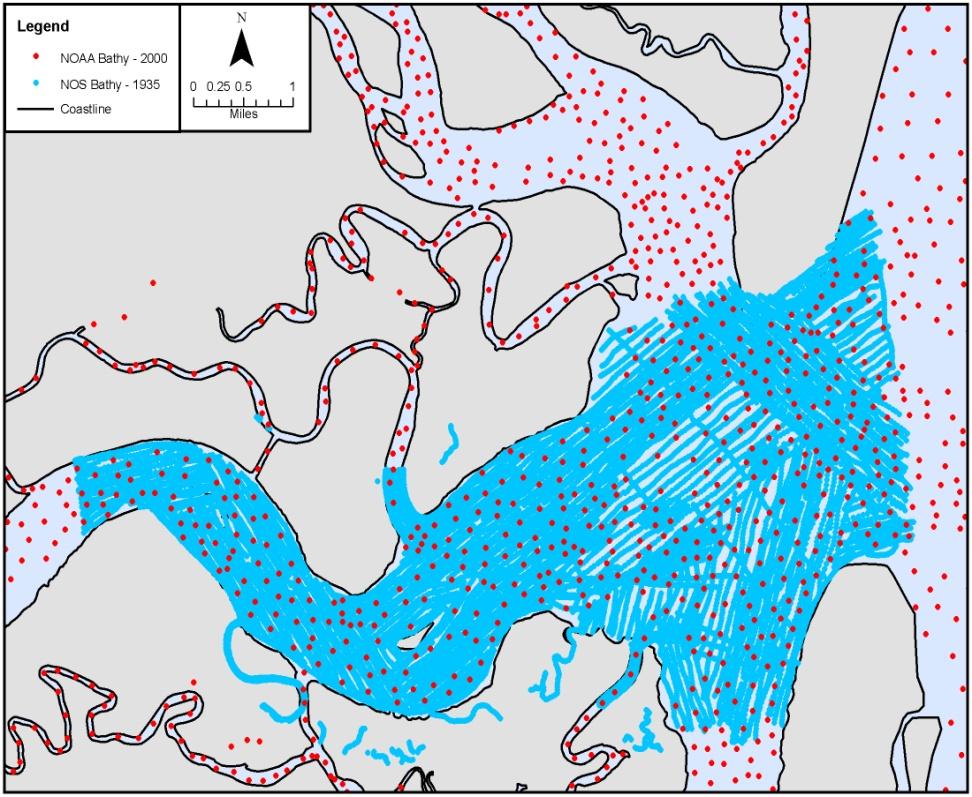
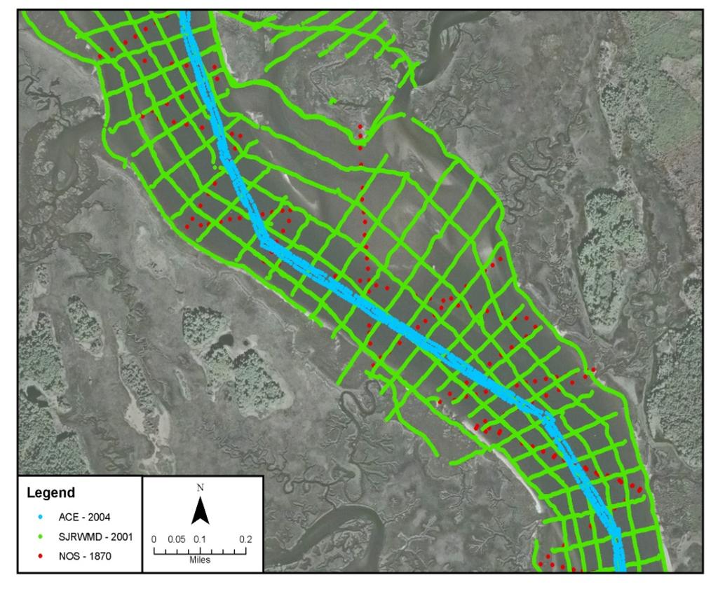
13 Gathered Bathymetric Data 13

14 Hurricane Model Mesh Development 14
 Nearshore: 80 200 m (260 655 feet) Offshore Boundary: 1 5 km (3,000 16,000")
15 Seamless Digital Elevation Model Mesh resolution 1,406,658 Nodes Complex Terrain/ Developed Areas: m ( feet) Nearshore: m ( feet) Offshore Boundary: 1 5 km (3,000 16,000 feet) 15

16 Hurricane Model Mesh Atlantic Basin 16

17 Hurricane Model Mesh Martin County St. Lucie Inlet, FL Sewall s Point ICWW St. Lucie River 17

18 Comparison of Old and New Mesh 18
19 Hurricane Modeling Validated tidal elevation modeling Reviewed historical storms Picked five storms to validate the hurricane/ surge model Generated hundreds of hypothetical storms 19

20 Validation Storm Selection: Tidal Elevations Astronomical tides simulated based on eight tidal constituents Modeled tides compared to 10 NOAA stations Agreement based on amplitude and phase 20

21 Storm Climatology: In Study Area Tropical storms: Passing within 175 NM of Melbourne, FL Limited data before

22 Validation Storm Selection: Significant Surge Events, Landfalling, bypassing, and exiting storms that passed near study area 22

23 Validation Storm Selection: Significant Surge Events 23
 2. Hurricane Frances (2004) 3. Hurricane Jeanne (2004) 4. Tropical Storm Tammy (2005) 5.")
24 Validation Storm Selection: Significant Surge Events (Cont d) Five validation storms selected 1. Hurricane Irene (1999) 2. Hurricane Frances (2004) 3. Hurricane Jeanne (2004) 4. Tropical Storm Tammy (2005) 5. Hurricane Wilma (2005) 24

25 Validation Storm Selection: Significant Surge Events (Cont d) 25
26 Validation: Summary Validation completed for tides and five historical storms Demonstrated model capability to reproduce water levels and waves in project area Comparisons to available data showed reasonable agreement for water levels and waves 26
27 Hypothetical Storms Developed using five parameters 1. Central pressure 2. Radius to maximum winds 3. Forward speed 4. Storm heading 5. Holland s B (shape parameter) Simulated whole range of possible storms for FL (based on historical data for area) Ran storms on high-speed computer Performed quality control reviews of results 27

28 Surge Modeling Gives 1-Percent Annual- Chance SWELs, Martin County Set up mesh for hurricane/ surge model Validated hurricane/surge model Ran hundreds of hypothetical storms Computed return periods for study area Storm surge SWELs for 1-percent-annual-chance event resulted 28
29 Overland Wave Analysis 29

30 Overland Wave Analysis (Cont d) 30


31 Martin County Transects 31


32 WHAFIS Modeling and Mapping 32


33 Primary Frontal Dune (PFD) a continuous or nearly continuous mound or ridge of sand with relatively steep seaward and landward slopes immediately landward and adjacent to the beach and subject to erosion and overtopping from high tides and waves during major coastal storms NFIP regulations 33


34 Wave Runup Modeling and Mapping 34
 No Federal insurance requirements tied to LiMWA CRS benefit for communities requiring VE zone construction standards in")
35 Limit of Moderate Wave Action (LiMWA) FEMA Procedure Memorandum No. 50, 2008 Not an NFIP regulatory requirement (at present) No Federal insurance requirements tied to LiMWA CRS benefit for communities requiring VE zone construction standards in areas defined by LiMWA (coastal A zone areas subject to waves greater then 1.5 feet, but less than 3 feet) 36

36 Combined Probability Mapping Coastal Riverine 37

37 Combined Probability Mapping (Cont d) 38

38 Combined Probability Mapping (Cont d) 39

39 Example FIRM 40

40 Example FIRM (Cont d) 41
41 Preliminary Map Package Sent to each community (CEOs and FPAs) on July 12, 2017 Package included: Updated Martin County FIRM Index panel Updated FIRM panels for community Updated Flood Insurance Study (FIS) report Preliminary Summary of Map Actions (SOMA) Digital data 42

42 Updated FIRM Panels 43
 Issued CCO Meeting and Flood Risk Open House Held")


43 Post-Preliminary Processing Milestones Preliminary Flood Insurance Rate Map (FIRM) Issued CCO Meeting and Flood Risk Open House Held Notices Published; Appeal Period Started Appeal Period Ends Letter of Final Determination Issued FIRM Effective Preliminary Phase Community Review 90-Day Appeal Period Administered Appeals Resolved & Map Products Finalized 6-Month Adoption/ Compliance Period Administereed 44
44 Schedule Moving Forward Preliminary FIRM Issued July 12, 2017 CCO Meeting/Flood Risk Open Houses Held March 22, 2018 Appeal Period Administered June-September 2018* Letter of Final Determination Issued December 2018* Adoption/Compliance Period Administered December 2018 June 2019* FIRM Effective June 2019* *estimated times 45
45 Appeal Period Martin County and incorporated communities will have a 90-day period to appeal new or revised flood hazard information shown on the FIRM and FIS report. Notice of changes published in the FEDERAL REGISTER, on the FEMA website, and twice in local newspapers within 10-day period Second newspaper publication begins 90-day appeal period Appeals are for new or revised flood hazard information. 46
46 What Is an Appeal? Appellant believes the new or revised flood hazard information is scientifically or technically incorrect. The information is scientifically incorrect if: The methodology used and assumptions made in the determination of the information are inappropriate or incorrect. The information is technically incorrect if: The methodology was not applied correctly or was based on insufficient or poor-quality data. The methodology did not account for the effects of physical changes that have occurred in the floodplain. 47

47 Data Submission Examples - Coastal Study Areas Storm surge and wave analysis (i.e., revised ADCIRC/SWAN model or other model) Revised WHAFIS transects/ analysis Revised PFD delineation Revised BFEs and flood hazard zones Newer topographic or bathymetric data Data certifications from Professional Land Surveyors/ Engineers 48
48 Comments During Appeal Period Martin County and incorporated communities also will have an opportunity to comment during the appeal period. Comments do not involve flood hazard information (BFEs, floodplain boundaries, etc.). Comments include, but are not limited to, the following: Channel name and location changes Road name and location changes Corporate limit changes Comments are change requests that do not involve hazard information. 49
49 Where to Submit Appeals and Comments Please have appeals and comments directed to your local floodplain administrator. Your local floodplain administrator can submit all appeals and comments to: Christopher Mack AECOM 4016 Salt Pointe Parkway North Charleston, SC FEMA will not move forward until your appeals and comments are resolved. 50
50 Appeal Resolution Process At end of 90-day appeal period, FEMA will: Acknowledge receipt of appeal(s)/comment(s) via letter(s) to CEO(s) Review appeal(s)/comment(s) and supporting data/ information Request additional data/information, if required Inform CEO(s) by letter of denial if appeal(s)/ comments not supported by data/information submitted FEMA will deny appeals and comments that are not adequately supported by data/information. 51
51 Appeal Resolution Process (Cont d) FEMA also will: Revise flood hazard information if appeal(s) adequately supported Revise other information if comment(s) adequately supported Prepare Revised Preliminary FIRM panel(s) and FIS report materials if necessary Send CEO(s) letter(s) to explain resolution of appeal(s)/ comment(s) and start review and comment period Community officials/appellants will have 30 days to review and comment on the resolution. 52

52 Letter of Final Determination (LFD) After 90-day appeal period elapses and appeals/ comments addressed, FEMA will issue LFDs. LFDs begin the 6-month adoption/ compliance periods, during which communities adopt the new FIRM into floodplain ordinances. Along with LFDs, FEMA sends Final SOMAs, informing CEOs/FPAs of Letters of Map Change (LOMCs) to be revalidated or superseded on the FIRM effective date. 53
53 Adoption/Compliance Period FDEM or FEMA Region IV staff may contact communities and offer assistance with reviewing and updating their floodplain ordinances. Ordinance may require update to adopt new FIRM, FIS report, and supporting technical data. Community may update ordinance any time after LFD is received. After adoption, communities send copies of their NFIP-compliant ordinances to FDEM and FEMA Region IV. 54
54 Adoption/Compliance Period (Cont d) FDEM and FEMA determine whether updated community ordinances are compliant. If a compliant ordinance is not received before the FIRM effective date, the community will be suspended from NFIP, so Please begin the ordinance review process as soon as you receive LFD. 55
55 Adoption/Compliance Period (Cont d) Communities can obtain technical support from FDEM staff by telephone at or by at For more information, please contact the Florida State NFIP Coordinator: Steve Martin 56

56 Effective FIRM During the adoption/compliance period, before the FIRM effective date, communities receive: Paper copies of effective FIRM Index, FIRM panels, and FIS report Digital data Revalidation Letter, effective 1 day after new FIRM effective date, informing community of LOMCs that are revalidated or superseded by new FIRM 57
 Letter of Map Revision Based on Fill (LOMR-F) Letter of Map")
57 Opportunities to Update Effective FIRM A FEMA flood hazard study update is NOT the only time the effective FIRM can be updated. The effective FIRM can be updated by LOMC: Letter of Map Amendment (LOMA) Letter of Map Revision Based on Fill (LOMR-F) Letter of Map Revision (LOMR) 58

 or electronically through www.fema.")
58 LOMA and LOMR-F (MT-EZ, MT-1) Provide administrative procedures for FEMA review of information from property owners who believe property has been inadvertently included in a designated Special Flood Hazard Area (SFHA) Can be submitted using paper form (MT-EZ or MT-1) or electronically through 59
 or electronically through www.fema.")
59 LOMR (MT-2) Applicable any time better data available Based on changes to hydrologic or hydraulic characteristics of flooding source that results in modification of BFEs, regulatory floodway, or SFHA Is a modification to an effective FIRM and/or FIS report; officially revises the FIRM and/or FIS report Can be submitted using paper forms (MT-2) or electronically through 60
60 Risk and Flood Insurance Determine your flood risk Nearly everyone is at some risk of flooding: High Risk SFHA, identified as Zone A, Zone AE, Zone V, or Zone VE on FIRM Moderate Risk Identified as shaded Zone X on FIRM Low Risk Identified as unshaded Zone X on FIRM 61

61 Risk and Flood Insurance (Cont d) Requirements in a high-risk zone Federally regulated lenders making new loans or modifying existing loans secured by buildings in SFHAs must require borrowers to purchase flood insurance for the term of the loan. 62


62 Flood Risk Open House Date: March 22, 2018 Venue: Time: Indian River State College Chastain Campus Wolf High-Technology Center 2400 SE Salerno Road Stuart, FL :00 p.m. 7:00 p.m. EST 63

63 Flood Risk Open House Layout 64


64 Questions & Answers Now & Later Mark A. Vieira, PE Henrietta Williams, CFM Danon Lucas Steve Martin, CFM Michael (Mike) DeRuntz, CFM Shannon Riess, CFM Jason Hunter, CFM Janice Mitchell 65


65 Questions & Answers Now & Later (Cont d) Chris Mack, PE, PMP Paul Carroll, PE, PMP Richard (Dick) Wild 66
St. Johns County, Florida Consultation Coordination Officer (CCO) Meeting. August 31, 2016 St. Augustine, Florida
 Meeting. August 31, 2016 St. Augustine, Florida") St. Johns County, Florida Consultation Coordination Officer (CCO) Meeting August 31, 2016 St. Augustine, Florida Agenda Introductions Coastal Study Update Study Process and Timeline Flood Insurance Implications
St. Johns County, Florida Consultation Coordination Officer (CCO) Meeting August 31, 2016 St. Augustine, Florida Agenda Introductions Coastal Study Update Study Process and Timeline Flood Insurance Implications
Duval County, Florida Consultation Coordination Officer (CCO) Meeting. January 25, 2017 Jacksonville, Florida
 Meeting. January 25, 2017 Jacksonville, Florida") Duval County, Florida Consultation Coordination Officer (CCO) Meeting January 25, 2017 Jacksonville, Florida Agenda Introductions Coastal Study Update Study Process and Timeline Flood Insurance Implications
Duval County, Florida Consultation Coordination Officer (CCO) Meeting January 25, 2017 Jacksonville, Florida Agenda Introductions Coastal Study Update Study Process and Timeline Flood Insurance Implications
Nassau County, Florida Consultation Coordination Officer (CCO) Meeting. February 24, 2016 Fernandina Beach, Florida
 Meeting. February 24, 2016 Fernandina Beach, Florida") Nassau County, Florida Consultation Coordination Officer (CCO) Meeting February 24, 2016 Fernandina Beach, Florida Agenda Introductions Coastal Study Update Study Process and Timeline Flood Insurance Implications
Nassau County, Florida Consultation Coordination Officer (CCO) Meeting February 24, 2016 Fernandina Beach, Florida Agenda Introductions Coastal Study Update Study Process and Timeline Flood Insurance Implications
Taylor County, Florida Community Coordination and Outreach (CCO) Meeting
 Meeting") Taylor County, Florida Community Coordination and Outreach (CCO) Meeting Suwannee River Water Management District April 26, 2017 11:00AM to 12:00PM Taylor County Administration Building, 201 E. Green Street,
Taylor County, Florida Community Coordination and Outreach (CCO) Meeting Suwannee River Water Management District April 26, 2017 11:00AM to 12:00PM Taylor County Administration Building, 201 E. Green Street,
Preliminary DFIRM Community Coordination (PDCC) Meeting Gilchrist & Levy Counties, FL. April 30, 2015
 Meeting Gilchrist & Levy Counties, FL. April 30, 2015") Preliminary DFIRM Community Coordination (PDCC) Meeting Gilchrist & Levy Counties, FL April 30, 2015 Agenda 1. Introductions 2. Study Process and Timeline 3. Overview of Preliminary Products 4. Overview
Preliminary DFIRM Community Coordination (PDCC) Meeting Gilchrist & Levy Counties, FL April 30, 2015 Agenda 1. Introductions 2. Study Process and Timeline 3. Overview of Preliminary Products 4. Overview
Middlesex County Timeline
 Community Coordination Meeting for Middlesex County, Connecticut Risk MAP Study November 9, 2011 Agenda Welcome and Introductions Project Timeline Coastal Flood Hazard Analysis Recap Public Review and
Community Coordination Meeting Sagadahoc County, Maine
 Community Coordination Meeting Sagadahoc County, Maine Risk MAP Study April 2, 2014 Agenda Welcome and Introductions Project Timeline Flood Hazard Analysis Recap Flood Risk Products Action: Hazard Mitigation
Community Coordination Meeting. York County, Maine. Risk MAP Study
 Community Coordination Meeting York County, Maine Risk MAP Study January 9, 2014 Agenda Welcome and Introductions Project Timeline Flood Hazard Analysis Recap (Digital Conversion, Riverine and Coastal)
Southwest Florida Discovery Kick-Off Meeting. February 4, 2014
 Southwest Florida Discovery Kick-Off Meeting February 4, 2014 Agenda Introductions Outline Risk MAP products and datasets Project scoping and schedule Data gathered Next steps Gather stakeholder input/feedback
Location: Tampa, Florida March 6, 2013
 Discovery Meeting: West Florida Coastal Study Location: Tampa, Florida March 6, 2013 Agenda Introductions Why we are here Outline Risk MAP products and datasets Discovery Overview: Project scoping and
N.C. Floodplain Mapping Program
 N.C. Floodplain Mapping Program Current Status and Update April 23, 2018 NCFMP Program Objectives Purpose: Develop, Maintain, and Disseminate current, accurate, digital flood hazard data for all of NC,
OTTAWA COUNTY AND SANDUSKY COUNTY COMMUNITY CONSULTATION OFFICERS (CCO) MEETING December 7, 2017
 MEETING December 7, 2017") OTTAWA COUNTY AND SANDUSKY COUNTY COMMUNITY CONSULTATION OFFICERS (CCO) MEETING December 7, 2017 TODAY S AGENDA The Value of Updated Flood Maps for Your Community Reviewing the Updated Flood Risk Data
OTTAWA COUNTY AND SANDUSKY COUNTY COMMUNITY CONSULTATION OFFICERS (CCO) MEETING December 7, 2017 TODAY S AGENDA The Value of Updated Flood Maps for Your Community Reviewing the Updated Flood Risk Data
Erie County Flood Risk Review Meeting. January 18, 2018
 Erie County Flood Risk Review Meeting January 18, 2018 Agenda The value of updated flood maps for your community Review updated flood-risk data and important next steps in the Risk MAP process Increasing
Cameron County, TX. Consultation Coordination Officer (CCO) Meeting. Please sign in (sheet at front of the room) Meeting will begin at 9:00
 Meeting. Please sign in (sheet at front of the room) Meeting will begin at 9:00") Cameron County, TX Consultation Coordination Officer (CCO) Meeting Please sign in (sheet at front of the room) Meeting will begin at 9:00 July 29, 2015 Lisa Jennings FEMA Region 6 Roles & Responsibilities
Cameron County, TX Consultation Coordination Officer (CCO) Meeting Please sign in (sheet at front of the room) Meeting will begin at 9:00 July 29, 2015 Lisa Jennings FEMA Region 6 Roles & Responsibilities
Physical Map Revisions as a Result of Updated Coastal Flood Hazards
 Physical Map Revisions as a Result of Updated Coastal Flood Hazards Agenda Coastal Flood Hazard Analysis Recap Public Review and Appeal Period Effect on Existing Letters of Map Change Insurance Questions
Updates to Maine Coastal Flood Insurance Rate Maps (FIRM s): What a Local Official Should Know. Presented by: Steve Johnson, P.E.
: What a Local Official Should Know. Presented by: Steve Johnson, P.E.") Updates to Maine Coastal Flood Insurance Rate Maps (FIRM s): What a Local Official Should Know Presented by: Steve Johnson, P.E. Town Engineer October 4, 2018 Introduction Federal Emergency Management
Updates to Maine Coastal Flood Insurance Rate Maps (FIRM s): What a Local Official Should Know Presented by: Steve Johnson, P.E. Town Engineer October 4, 2018 Introduction Federal Emergency Management
Flood Map Revisions. Town of Nags Head Public Information and Input Session. December 14, 2016, 6 pm
 Flood Map Revisions Town of Nags Head Public Information and Input Session December 14, 2016, 6 pm Flood Map Revisions New preliminary flood maps released for Dare County June 30, 2016 www.nagsheadnc.gov/floodmaps
9/20/2016. Orange County Preliminary FIRM / Consultation Coordination Officer (CCO) Meeting
 Meeting") Orange County Preliminary FIRM / Consultation Coordination Officer (CCO) Meeting Open Pacific Coast Study September 21 and 22, 2016 1 Welcome and Introductions Preliminary FIRM / CCO Meeting Orange County
Orange County Preliminary FIRM / Consultation Coordination Officer (CCO) Meeting Open Pacific Coast Study September 21 and 22, 2016 1 Welcome and Introductions Preliminary FIRM / CCO Meeting Orange County
Bullitt County, Kentucky Preliminary DFIRM Community Open House. October 8, 2014 Shepherdsville, Kentucky
 Bullitt County, Kentucky Preliminary DFIRM Community Open House October 8, 2014 Shepherdsville, Kentucky Meeting Agenda Introductions Overview of Preliminary DFIRMs Overview of Map Appeal Process Questions
Preliminary Work Map Release
 Coastal Mapping in New Jersey Preliminary Work Map Release Monmouth County, New Jersey June 14, 2013 Agenda Introduction and Purpose of Briefing Hurricane Sandy Advisory Base Flood Elevations Transitioning
Durham County Preliminary Flood Hazard Data Public Meeting. July 28, 2016
 Durham County Preliminary Flood Hazard Data Public Meeting July 28, 2016 Why Are We Here New flood hazard data has been released as Preliminary for Durham County Statutory Due Process for review/comments
National Flood Insurance Program. Jennifer Gilbert, CFM, ANFI New Hampshire NFIP State Coordinator
 National Flood Insurance Program Jennifer Gilbert, CFM, ANFI New Hampshire NFIP State Coordinator What is the National Flood Insurance Program? Created by Congress in 1968 Participating Communities voluntarily
Enough about me! Topics Covered
 About Me Worked in land surveying since 1997 Employed by the City of Orlando since 2006 City of Orlando City Surveyor since February 2015 Certified Floodplain Manager since 2015 Florida Licensed Surveyor,
Community Officials Meeting. Plumas and Sierra County Physical Map Revision
 Community Officials Meeting Plumas and Sierra County Physical Map Revision March 6, 2014 Agenda Introductions/Sign In Project Scope Sierra Valley Flood Study (Plumas and Sierra Counties) North Yuba River
Coastal Flood Insurance Studies in Virginia and Climate Change
 Coastal Flood Insurance Studies in Virginia and Climate Change VFMA Floodplain Management Workshop October 22, 2015 Jeff Gangai Why is a Coastal Restudy Needed? New Guidelines need to be implemented Atlantic
WAYNE COUNTY COMMUNITY CONSULTATION OFFICERS (CCO) MEETING. February 27, 2019
 MEETING. February 27, 2019") WAYNE COUNTY COMMUNITY CONSULTATION OFFICERS (CCO) MEETING February 27, 2019 TODAY S AGENDA Review the Updated Flood Risk Data for Your County Next Steps in the Map Adoption Process Understanding Flood
WAYNE COUNTY COMMUNITY CONSULTATION OFFICERS (CCO) MEETING February 27, 2019 TODAY S AGENDA Review the Updated Flood Risk Data for Your County Next Steps in the Map Adoption Process Understanding Flood
LOCAL OFFICIALS MEETING Lake Wausau Physical Map Revision MARATHON COUNTY, WISCONSIN FEBRUARY 9, 2017
 LOCAL OFFICIALS MEETING Lake Wausau Physical Map Revision MARATHON COUNTY, WISCONSIN FEBRUARY 9, 2017 Welcome & Introduction Michelle Staff Floodplain Management Policy Coordinator, WDNR Michelle.Staff@Wisconsin.gov
Calhoun County Flood Insurance Study Update
 Calhoun County Flood Insurance Study Update Larry Voice FEMA Region VI September 18, 2009 AGENDA Introduction Study Overview and Status Update Levees Post-Preliminary Process Outreach Moving Forward 2
Abington Township Public Meeting
 Abington Township Public Meeting Flood Insurance Rate Map Update March 23, 2016 1 Meeting Agenda and Format Provide residents/property owners of Abington Township with information about the map update,
Federal Emergency Management Agency
 Page 1 of 4 Issue Date: April 11, 2013 Case No.: DETERMINATION DOCUMENT COMMUNITY AND REVISION INFORMATION PROJECT DESCRIPTION BASIS OF REQUEST Town Of Stratford Fairfield County Connecticut NO PROJECT
Herkimer County, New York Flood Hazard Mapping Status Report for Property Owners
 Herkimer County, New York Flood Hazard Mapping Status Report for Property Owners Herkimer County, New York Flood Hazard Mapping Status Report for Property Owners FLOOD INSURANCE Who Should Purchase Flood
Federal Emergency Management Agency
 Page 1 of 4 Issue Date: February 14, 2013 Effective Date: June 28, 2013 DETERMINATION DOCUMENT COMMUNITY AND REVISION INFORMATION City of Sunny Isles Beach Miami-Dade County Florida PROJECT DESCRIPTION
Federal Emergency Management Agency
 Page 1 of 5 Issue Date: July 27, 2012 Effective Date: December 10, 2012 Case No.: 11-06-4512P Follows Conditional Case No.: 06-06-B789R LOMR-APP Federal Emergency Management Agency Washington, D.C. 20472
NFIP Mapping Issues. Wendy Lathrop, PLS, CFM. Cadastral Consulting, LLC
 NFIP Mapping Issues Cadastral Consulting, LLC NFIP Basic Objectives: Reduce the exposure to flood damages through the use of minimum standards for the placement and design of structures located in flood
Federal Emergency Management Agency
 Page 1 of 4 Issue Date: August 1, 2012 Effective Date: December 13, 2012 Case No.: 12-06-0595P LOMR-APP Washington, D.C. 20472 LETTER OF MAP REVISION DETERMINATION DOCUMENT COMMUNITY AND REVISION INFORMATION
FOR LOCAL GOVERNMENTS
 FLOOD MAP OUTREACH PLANNING GUIDEBOOK FOR LOCAL GOVERNMENTS Version 1.1 Georgia Department of Natural Resources March 2010 Dear Community Official: Georgia s Department of Natural Resources (DNR) has partnered
REAL ESTATE FLOOD DISCLOSURE PROGRAM & FLOOD MAP INFORMATION SERVICES
 REAL ESTATE FLOOD DISCLOSURE PROGRAM & FLOOD MAP INFORMATION SERVICES Lisa Foster, CFM, Floodplain Coordinator ldfoster@pinellascounty.org January 26, 2018 Why are you here? Save your clients money on
FEMA Region IX May 30-31, 2017
 Ventura County Preliminary Flood Maps FEMA Region IX May 30-31, 2017 National Flood Insurance Program U.S. Congress established the NFIP with the passage of the National Flood Insurance Act of 1968: 1.
Northern Alameda County Consultation Coordination Officer (CCO) Meeting
 Meeting") MEETING TITLE: DATE AND TIME: Northern Alameda County Consultation Coordination Officer (CCO) Meeting May 27, 2015, 1:30 to 3:30 p.m. LOCATION: 950 West Mall Square, Room 201 Alameda, CA ATTENDEES: Eric
MEETING TITLE: DATE AND TIME: Northern Alameda County Consultation Coordination Officer (CCO) Meeting May 27, 2015, 1:30 to 3:30 p.m. LOCATION: 950 West Mall Square, Room 201 Alameda, CA ATTENDEES: Eric
JAXGIS FEMA Flood Hazard Mapping -- Frequently Asked Questions
 Flood Hazard Zone Designations Summary Zones starting with the letter 'A' (for instance, Zone A, Zone AE, Zone AH, Zone AO) denote a Special Flood Hazard Area, which can also be thought of as the 100-year
Bucks County, PA Flood Risk Review Meeting. November 2014
 Bucks County, PA Flood Risk Review Meeting November 2014 Agenda for Today Risk MAP Program overview Overview of non-regulatory Flood Risk Products and datasets Discuss mitigation action Technical overview
INSTRUCTIONS FOR COMPLETING THE APPLICATION FORMS FOR CONDITIONAL LETTERS OF MAP REVISION AND LETTERS OF MAP REVISION
 INSTRUCTIONS FOR COMPLETING THE APPLICATION FORMS FOR CONDITIONAL LETTERS OF MAP REVISION AND LETTERS OF MAP REVISION GENERAL In 1968, the U.S. Congress passed the National Flood Insurance Act, which created
Kevin Wagner Maryland Department of the Environment
 Kevin Wagner Maryland Department of the Environment Topics Overview of the National Flood Insurance Program (NFIP) Mapping Regulations Insurance Mitigation Community Rating System (CRS) Questions Know
Skagit County Flood Insurance Study Update. Ryan Ike, CFM FEMA Region 10
 Skagit County Flood Insurance Study Update Ryan Ike, CFM FEMA Region 10 Skagit County Flood Insurance Study Process Overview Process, Schedule, & Deliverables Base Flood Elevations, Modeling, & Levees
ASSUMPTION PARISH, LOUISIANA AND INCORPORATED AREAS
 VOLUME 1 of 1 ASSUMPTION PARISH, LOUISIANA AND INCORPORATED AREAS COMMUNITY NAME ASSUMPTION PARISH UNINCORPORATED AREAS COMMUNITY NUMBER 220017 NAPOLEONVILLE, TOWN OF 220018 REVISED PRELIMINARY November
Federal Emergency Management Agency
 Page 1 of 3 COMMUNITY AND MAP PANEL INFORMATION COMMUNITY CITY OF MARGATE CITY, ATLANTIC COUNTY, NEW JERSEY LEGAL PROPERTY DESCRIPTION A parcel of land, as described in Deed recorded in Book 4826, page
Floodplain Management 101: UNIT II. Maps & Flood Insurance Studies
 Floodplain Management 101: UNIT II Maps & Flood Insurance Studies Who is ASFPM? ASFPM stands for the Association of State Floodplain Managers A national organization of floodplain management professionals
Requirements for Construction on Properties in the Special Flood Hazard Area (SFHA)
") Requirements for Construction on Properties in the Special Flood Hazard Area (SFHA) Rev 010915 The website for the IDNR to request the EFARA (Electronic Floodplain Analysis/Regulatory Assessment is found
Requirements for Construction on Properties in the Special Flood Hazard Area (SFHA) Rev 010915 The website for the IDNR to request the EFARA (Electronic Floodplain Analysis/Regulatory Assessment is found
Orange County Flood Insurance Study Update
 Orange County Flood Insurance Study Update Larry Voice FEMA Region VI August 26, 2009 AGENDA Introduction Study Overview and Status Update Levees Post-Preliminary Process Outreach Moving Forward 2 Introduction
Federal Emergency Management Agency
 Page 1 of 4 Issue Date: April 26, 2013 DETERMINATION DOCUMENT COMMUNITY AND REVISION INFORMATION PROJECT DESCRIPTION BASIS OF REQUEST City of Coppell Dallas County Texas FILL HYDRAULIC ANALYSIS NEW TOPOGRAPHIC
THE FEDERAL EMERGENCY MANAGEMENT AGENCY. Letters of Map Change Kristen Martinenza, P.E., CFM FEMA Region IV
 THE FEDERAL EMERGENCY MANAGEMENT AGENCY Letters of Map Change Presented by: Kristen Martinenza, P.E., CFM FEMA Region IV 1 NATIONAL FLOOD INSURANCE ACT OF 1968 At the start of the program, there was not
SECTION 9: MAPS AND DATA
 SECTION 9: MAPS AND DATA Contents 9.1. NFIP Maps and Data... 9-2 9.1.1. Adopting and enforcing NFIP floodplain maps and data... 9-2 9.1.2. Adopting and enforcing more restrictive data... 9-2 9.1.3. Annexations...
FLOODPLAIN FAQ s. Last Update: June 2017
 FLOODPLAIN FAQ s Last Update: June 2017 What does FEMA stand for? Federal Emergency Management Agency - the operation of FEMA is to lead America to prepare for, prevent, respond to, and recover from disasters.
Analysis and Mapping Procedures for Non-Accredited Levees
 Analysis and Mapping Procedures for Non-Accredited Levees Proposed Approach for Public Review December 9, 2011 www.fema.gov/plan/prevent/fhm/rm_main.shtm 1 877 FEMA MAP Executive Summary Background This
Pinellas County Flood Map Information Service & Real Estate Disclosure Program Training January 26, 2017 COMMON FLOODPLAIN ACRONYMS
 FEMA ASFPM BFE CAV Pinellas County Flood Map Information Service & Real Estate Disclosure Program Training COMMON FLOODPLAIN ACRONYMS Federal Emergency Management Agency Association of State Floodplain
Sandy + BW-12: Changing the Equation for Building Safer, More Resilient Communities
 Sandy + BW-12: Changing the Equation for Building Safer, More Resilient Communities Grant Smith Jerry Sparks Jean Huang Ken Logsdon Stephanie Routh Session Agenda Moderators: Grant Smith & Jerry Sparks
Door County Floodplain Program Informational Meeting
 Door County Floodplain Program Informational Meeting Door County Land Use Services Department Wisconsin Department of Natural Resources January 15, 2018 Floodplain = Land affected by flood event with a
The New Maryland Model Floodplain Management Ordinance
 Department of the Environment The New Maryland Model Floodplain Management Ordinance MAFSM Conference October 21, 2010 Kevin G. Wagner Agenda Brief history/background What s driving new ordinances Introduction
Federal Emergency Management Agency
 Page 1 of 4 Issue Date: September 7, 2012 Effective Date: January 22, 2013 DETERMINATION DOCUMENT COMMUNITY COMMUNITY AND REVISION INFORMATION City of Lubbock Lubbock County Texas PROJECT DESCRIPTION CHANNELIZATION
National Coastal Outreach
 National Coastal Outreach Answering Tough Questions June 11, 2013 Why Focus on Coastal Flood Risk? 120,475,000 people or 39% of the U.S. population live in counties subject to the 1% annual chance coastal
Georgia Flood M.A.P. Program Risk MAP Plenary Session GAFM 2011
 Georgia Flood M.A.P. Program Risk MAP Plenary Session GAFM 2011 Collis Brown, Georgia DNR March 24, 2011 GA Flood Map Modernization Responsible for end-to-end production Developed aggressive outreach program
THE $64,000 FLOOD INSURANCE BILL
 THE $64,000 FLOOD INSURANCE BILL GEORGIA ASSOCIATION OF FLOODPLAIN MANAGERS 9 TH ANNUAL TECHNICAL CONFERENCE Patrick Gervais, PE, CFM A CASE STUDY IN FLOOD INSURANCE This is a true story that happened
Federal Emergency Management Agency
 Page 1 of 5 Issue Date: June 21, 2013 Follows Conditional Case No.: 04-06-A148R DETERMINATION DOCUMENT COMMUNITY COMMUNITY AND REVISION INFORMATION City of Irving Dallas County Texas FILL PROJECT DESCRIPTION
Panel Decision & Report. SRP MAES Ring s Island, Salisbury, Essex County, Massachusetts
 Panel Decision & Report SRP MAES042211 Ring s Island, Salisbury, Essex County, Massachusetts Table of Contents Summary... 2 About the Scientific Resolution Panel (SRP) and Authority... 2 Panel Members...
AGENDA PLANNING ADVISORY BOARD SUBCOMMITTEE INDUSTRIAL STANDARDS FOR CONSTRUCTION WITHIN A FLOODPLAIN THURSDAY, AUGUST 25, :00-5:00 P.M.
 AGENDA PLANNING ADVISORY BOARD SUBCOMMITTEE INDUSTRIAL STANDARDS FOR CONSTRUCTION WITHIN A FLOODPLAIN THURSDAY, AUGUST 25, 2016 3:00-5:00 P.M. CITY COMMISSION CHAMBERS 204 ASH STREET FERNANDINA BEACH,
Volusia County Floodplain Management Plan 2012
 Volusia County Floodplain Management Plan 2012 Introduction The National Flood Insurance Program (NFIP) provides federally supported flood insurance in communities that regulate development in floodplains.
Accounting for Long-Term Erosion and Sea Level Rise in New England: A TMAC Recommendation
 Accounting for Long-Term Erosion and Sea Level Rise in New England: A TMAC Recommendation Elena Drei-Horgan, PhD, CFM Jeremy Mull, PE Brian Caufield, PE May 2017 Establishment of TMAC, Definition, Members
COLLIER COUNTY FLOODPLAIN MANAGEMENT
 COLLIER COUNTY FLOODPLAIN MANAGEMENT FREQUENTLY ASKED QUESTIONS The following information is based on common questions from the public. If you have a specific question or need further information, please
Discovery Meeting: Lake Ontario. FEMA REGION II November 12-14, 2013 and November 19-21, 2013 Lake Ontario Contributing Watersheds
 Discovery Meeting: Lake Ontario FEMA REGION II November 12-14, 2013 and November 19-21, 2013 Lake Ontario Contributing Watersheds Introductions and Who s Here Project Team FEMA Region II Dewberry New York
Table 1: Federal, State and Local Government Rules applicable to LOMRs/CLOMRS submittal
 MnDNR LOMC Guide This document has been prepared by the Minnesota Department of Natural Resources floodplain staff and is intended to provide assistance with LOMR/CLOMR submittals. This information is
Consultation Coordination Officer (CCO) Meeting
 Meeting") Consultation Coordination Officer (CCO) Meeting Middle Brazos Lake Whitney Physical Map Revision Hill and McLennan Counties FEMA Region 6 Agenda National Flood Insurance Program Purpose of the Meeting
Consultation Coordination Officer (CCO) Meeting Middle Brazos Lake Whitney Physical Map Revision Hill and McLennan Counties FEMA Region 6 Agenda National Flood Insurance Program Purpose of the Meeting
Questions about the National Flood Insurance Program
 Questions about the National Flood Insurance Program Federal Emergency Management Agency (FEMA) Questions and Answers What is the National Flood Insurance Program (NFIP)? The NFIP is a Federal program
What Was Updated in 2004 in Hennepin Countywide Maps?
 What Was Updated in 2004 in Hennepin Countywide Maps? Combined the city and township maps into one countywide index Done by USACE Mainly digital capture of old floodplain boundaries; some spots with shifts
JOINT STUDY ON FLOOD ELEVATIONS AND BUILDING HEIGHT REQUIREMENTS PURSUANT TO 2015 N.C. SESS. LAW 286. Presented by:
 JOINT STUDY ON FLOOD ELEVATIONS AND BUILDING HEIGHT REQUIREMENTS PURSUANT TO 2015 N.C. SESS. LAW 286 Presented by: Dan H. Tingen Chairman of the North Carolina Building Code Council Rick McIntyre North
Flood Plain Management Services (FPMS) Program
 Program") Flood Plain Management Services (FPMS) Program 2016 Winter Stakeholder Partnering Forum March 2016 Mario Beddingfield, P.E., CFM Hydraulic Engineer/FPMS Program Manager H&H/Water Control Branch U.S. Army
Flood Plain Management Services (FPMS) Program 2016 Winter Stakeholder Partnering Forum March 2016 Mario Beddingfield, P.E., CFM Hydraulic Engineer/FPMS Program Manager H&H/Water Control Branch U.S. Army
Best Practices. for Incorporating Building Science Guidance into Community Risk MAP Implementation November 2012
 Best Practices for Incorporating Building Science Guidance into Community Risk MAP Implementation November 2012 Federal Emergency Management Agency Department of Homeland Security 500 C Street, SW Washington,
Lake Erie. June 10 & 11, 2014
 Discovery Meeting: Lake Erie FEMA REGION II June 10 & 11, 2014 Lake Erie Contributing Watersheds eds Introductions and Who s Here Project Team FEMA Region II RAMPP Local Stakeholders Invited Local Community
Flood Analysis Memo. 629 Orangewood Dr. Dunedin, FL BFE = 21 ft
 Flood Analysis Memo Property Address 629 Orangewood Dr. In Partnership with: ** This property is NOT within a high-risk flood zone ** 629 Orangewood Dr. BFE = 21 ft This property is located in the FEMA
History of Floodplain Management in Ascension Parish
 History of Floodplain Management in Ascension Parish presented by: Kara Moree Floodplain Coordinator February 6, 2012 Floodplain 101 Floodplain 101 Base or 1% Flood: A flood having a 1% chance of being
Coastal Flood Maps. Chris Penney. Program Manager USACE Baltimore District 2 June US Army Corps of Engineers BUILDING STRONG
 Coastal Flood Maps Chris Penney Program Manager USACE Baltimore District 2 June 2015 US Army Corps of Engineers There are two types of coastal flood risk maps They look different They communicate different
Federal Emergency Management Agency
 Page 1 of 5 Issue Date: October 16, 2014 Effective Date: March 2, 2015 Case No.: 14-09-2279P LOMR-APP Federal Emergency Management Agency Washington, D.C. 20472 LETTER OF MAP REVISION DETERMINATION DOCUMENT
July 31, 2017 NFIP Flood Map Open House Flood Maps 101 Flood Mapping acronyms History of the NFIP Flood Mapping Updates Flood Insurance Fairhope,
 July 31, 2017 NFIP Flood Map Open House Flood Maps 101 Flood Mapping acronyms History of the NFIP Flood Mapping Updates Flood Insurance Fairhope, Alabama Flood Maps Fairhope Permitting Jurisdiction Coastal
NFIP Overview Elevation Certificate Flood Insurance Rate Maps. By: Maureen O Shea, AICP, CFM State NFIP Coordinator
 NFIP Overview Elevation Certificate Flood Insurance Rate Maps By: Maureen O Shea, AICP, CFM State NFIP Coordinator Example of a flood failure Example of a flood failure Purposes of the NFIP Identify &
Flood Risk Review (FRR) Meeting. Cumberland County, Pennsylvania Carlisle, Pennsylvania December 5, 2016
 Meeting. Cumberland County, Pennsylvania Carlisle, Pennsylvania December 5, 2016") Flood Risk Review (FRR) Meeting Cumberland County, Pennsylvania Carlisle, Pennsylvania December 5, 2016 Why are we here today? The Flood Insurance Study (FIS) report and Flood Insurance Rate Maps (FIRMs)
Flood Risk Review (FRR) Meeting Cumberland County, Pennsylvania Carlisle, Pennsylvania December 5, 2016 Why are we here today? The Flood Insurance Study (FIS) report and Flood Insurance Rate Maps (FIRMs)
10526 Bermuda Isle Dr. Tampa, FL 33647
 Flood Analysis Memo Property Address 10526 Bermuda Isle Dr. In Partnership with: ** This property is NOT within a high-risk flood zone ** 10526 Bermuda Isle Dr. BFE = 35 ft This property is located in
Introduction to the National Flood Insurance Program: A Guide for Coastal Property Owners MAINE BEACHES CONFERENCE 2017
 Introduction to the National Flood Insurance Program: A Guide for Coastal Property Owners MAINE BEACHES CONFERENCE 2017 SUE BAKER, CFM STATE NFIP COORDINATOR MAINE DEPT OF AGRICULTURE, CONSERVATION & FORESTRY
Napa & Solano County, California San Francisco Bay Area Coastal Study
 Napa &, California San Francisco Bay Area Coastal Study April 2014 www.r9coastal.org The Napa and shoreline is part of the San Francisco Bay Area Coastal Study conducted under the Federal Emergency Management
F E M A Mapping Changes. FEMA Mapping Changes. National Flood Insurance Program
 FEMA Mapping Changes National Flood Insurance Program 1 Welcome to FEMA Mapping Changes! We will get started in a few minutes. Meanwhile, let s perform a warm up exercise. 2 1 Training Agenda Section 1-
If you have any questions or concerns please give us a call at , or Walter Jenkins at (ext 300).
.") FLORIDA ZONE SERVICES Flood Insurance and Zone Consulting 461 SE 3 rd Terrace Pompano Beach, FL 33060 Phone 954-290-7420 bspencer@florida-floodzone.com March 6, 2014 Dear Pebblebrook II Homeowner: We informing
FLORIDA ZONE SERVICES Flood Insurance and Zone Consulting 461 SE 3 rd Terrace Pompano Beach, FL 33060 Phone 954-290-7420 bspencer@florida-floodzone.com March 6, 2014 Dear Pebblebrook II Homeowner: We informing
MEIGS COUNTY UNINCORPORATED AREAS
 VOLUME 1 MEIGS COUNTY, OHIO AND INCORPORATED AREAS COMMUNITY NAME COMMUNITY NUMBER MEIGS COUNTY UNINCORPORATED AREAS 390387 MIDDLEPORT, VILLAGE OF 390388 POMEROY, VILLAGE OF 390389 RACINE, VILLAGE OF 390390
10526 Bermuda Isle Dr. Tampa, FL 33647
 Flood Analysis Memo Property Address In Partnership with: ** This property is NOT within a high-risk flood zone ** This property is located in a FEMA low-risk zone designated as Zone X - an area of minimal
Repetitive Loss Area Revisit # 6 Walter Road Area Jefferson Parish
 Repetitive Loss Area Revisit # 6 Walter Road Area Jefferson Parish www.floodhelp.uno.edu Supported by FEMA Acknowledgement The compilation if this report was managed by Erin Patton, CFM, a UNO-CHART Research
Federal Emergency Management Agency
 Federal Emergency Management Agency Washington, D.C. 20472 August 16, 2016 CERTIFIED MAIL IN REPLY REFER TO: RETURN RECEIPT REQUESTED Case No.: 16-07-1180P Community Name: City of Overland Park, KS The
FLOOD STUDY Atlantic County, NJ. FEMA REGION II July 12, :00
 FLOOD STUDY Atlantic County, NJ FEMA REGION II July 12, 2011 14:00 Agenda Introductions FEMA Strategic Plan & Risk Mapping, Assessment, and Planning (Risk MAP) Goals Risk MAP Program Overview Meeting Objectives
Federal Emergency Management Agency
 Page 1 of 6 Issue Date: October 24, 2012 Effective Date: March 7, 2013 Case No.: LOMR-APP DETERMINATION DOCUMENT COMMUNITY AND REVISION INFORMATION PROJECT DESCRIPTION BASIS OF REQUEST City of Lubbock
Flood: How to Protect Your Business from a Natural Disaster
 Flood: How to Protect Your Business from a Natural Disaster Speakers: Greg Bates, Managing Consultant, Global Risk Consultants (GRC) Frank Francone, Manager, Insurance & Risk Services, General Growth Properties
Floodplain Management 101. Mississippi Emergency Management Agency Floodplain Management Bureau
 Floodplain Management 101 Mississippi Emergency Management Agency Floodplain Management Bureau Stafford Act The Stafford Disaster Relief and Emergency Assistance Act (Stafford Act) (Public Law 100-707)
Discovery Report Coastal Flood Study Westchester County New York Report Number 01 1/31/2014
 Discovery Report Coastal Flood Study Westchester County New York Report Number 01 1/31/2014 Federal Emergency Management Agency Department of Homeland Security 26 Federal Plaza New York, NY Project Area
MT-1 Basics: A Comprehensive Overview of LOMAs and Discussion of Common Application Setbacks
 MT-1 Basics: A Comprehensive Overview of LOMAs and Discussion of Common Application Setbacks Introduction: Terminology MT-1s vs. MT-2s LOMAs vs. LOMRs What is a LOMC? Letters of Map Change (LOMCs) MT-1s
Cumberland County, NJ. Risk MAP Project Status Update April 22, 2013
 Cumberland County, NJ Risk MAP Project Status Update April 22, 2013 Agenda Project Team Milestones Risk MAP Overview Study Scope overview Regulatory products Non-regulatory products Proposed Schedule Risk