Coastal Flood Insurance Studies in Virginia and Climate Change
|
|
|
- Cora Hart
- 5 years ago
- Views:
Transcription


1 Coastal Flood Insurance Studies in Virginia and Climate Change VFMA Floodplain Management Workshop October 22, 2015 Jeff Gangai
2 Why is a Coastal Restudy Needed? New Guidelines need to be implemented Atlantic Ocean and Gulf of Mexico Guidelines Update (2007) Sheltered Waters Report (2008) PM 50 Limit of Moderate Wave Action (LiMWA) (2008) and new 2013 OG To update base data such as topographic dataset and aerial imagery to high resolution products and seamless Digital Elevation Model (DEM) To utilize newer coastal hazard methodologies developed during the FEMA Mississippi Coastal Restudy To take advantage of higher performance numerical modeling To take advantage of improvement in GIS technologies to allow for more precise FIRMs 2

3 Modern GIS-Integrated FIS Modeling 3


4 Technology = Efficiency = Increased Precision Example, Suffolk County, NY 1,200 miles of ocean and estuarine shoreline Existing FIRM = 208 coastal transects GeoCoastal application allowed 1611 transects for typical study budget 670% increase in resolution Results easier to defend due to detail of analysis 4


5 Map Modernization New digital FIRMs more precisely represent current flood risk Countywide digital FIRMS easier to use and update 98% of communities in Region III now have digital FIRMs 5

6 Why is a Coastal Restudy Needed? 6

7 Region III Coastal Study Timeline Surge Study Results Winter 2011 Coastal Hazard Analysis Results Spring Summer 2014 Preliminary FIRMs Summer 2013 Spring 2015 Letter of Final Determination Spring 2014 Winter 2015 New Effective Coastal FIRMs Fall 2014 Summer


8 Coastal FIS Project Life-cycle 8
9 Region III Coastal FIRM Status (Hampton Roads) Gloucester 11/19/2014 Newport News 12/09/2014 Chesapeake, Poquoson 12/16/2014 Virginia Beach, York 01/16/2015 Surry 05/04/2015 Suffolk, Portsmouth 08/03/2015 Isle of Wight 12/02/2015 James City/Williamsburg 12/16/2015 Hampton 05/16/2016 Norfolk 90-day appeal period ended September 2015 (1 appeal received) 9


10 FEMA REGION III COASTAL STORM SURGE STUDY Jeff Hanson, Ph.D. Project Leader Mike Forte Project Specialist 10

11 FEMA Region III Study Area Four states plus District of Columbia Five metropolitan areas Complex coastal geomorphology Delaware River/Bay system - Tidal up to Trenton, NJ square mile bay - Strategic shipping and military port Chesapeake bay - Third largest estuary in world - 11,000 miles of tidal shoreline - Major shipping, seafood and military ports 11


12 Storm Surge Study Approach Storm Forcing Extratropical Wind Fields Hurricane Tracks High-Resolution Bathymetry/Topography Storm Surge Modeling Winds Wave s Water Levels Statistical Analysis completed in order to determine Return Period 10%, 2%, 1% and 0.2% annual chance stillwater elevations 12
 and were")
 model 1978 Mesh 3-6 mile resolution 2011 Mesh 100 ft Minimum")
13 Improvement in Modeling Capabilities Current stillwater elevations (SWELs) on FIRMs date back to (few updates made in early-1990s) and were computed using a tidal gage analysis or the Virginia Institute of Marine Sciences (VIMS) model 1978 Mesh 3-6 mile resolution 2011 Mesh 100 ft Minimum Resolution 13
 Wind speed and direction Water levels High water")
14 Modeling System Validation Validation Storms Hurricane Isabel (SEP 03) Hurricane Ernesto (AUG 06) Extratropical Storm Ida (Nov 09) Hurricane Isabel September 2003 Validation Parameters Tides Hurricane Ernesto (AUG 06) Wind speed and direction Water levels High water marks 14


15 High Water Marks: Hurricanes Isabel and Ernesto Hurricane Isabel September 2003 Extra-tropical Storm Ida November 2009 Circles depict observed high water marks to same color scale as background surge predictions 15


16 Production Run Storms Extratropical Storms February 4, 1998 Pressure Field 30 Top ranked storms Based on water levels at 10 stations Careful reanalysis of wind/pressure fields Tropical Storms Record of 20 hurricanes in 60 years insufficient for 100- yr analysis 156 Representative events sampled from ASCE 100,000-year synthetic storm set 156 Simulated Hurricane Tracks A 1-year effort! Intensities range from Tropical Storm to Cat 3 Demonstrated validity with comparisons to historic data 16
")
17 Tidal Contributions Average High Tide Elevation MHHW above MSL (m) 17


18 Updated SWEL Hurricanes Extratropicals Combined Elevation (ft, MSL) 18
 Orange: 1-2 ft higher Green: Less than 1 ft change Blue: 1-3 ft")
19 Hampton Roads Area Difference between updated and published 100-yr SWELs (ft) (Updated published) Orange: 1-2 ft higher Green: Less than 1 ft change Blue: 1-3 ft lower 19


20 Coastal Study Resources - Storm Surge Study 1.1 DEM 1.2 Modeling System 1.3 Storm Forcing 2. Model Validation 3. Final Analysis Coastal Storm Surge Analysis: Final Report Methods and results Released as formal reports Available at or 20
21 Coastal Study Process TERRAIN PROCESSING STORM SURGE ANALYSIS STARTING WAVE CONDITION ANALYSIS TRANSECT LAYOUT & FIELD RECONNAISSANCE FRONTAL DUNE DELINEATION STORM-INDUCED EROSION OVERLAND WAVE HEIGHT & RUNUP ANALYSIS FLOODPLAIN BOUNDARY & FLOOD HAZARD ZONE MAPPING 21


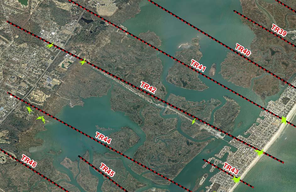
22 Transect Placement Transect Layout City of Virginia Beach 22


23 Overland Wave Hazard Modeling Storm-induced erosion Primary frontal dunes Erodible bluffs WHAFIS 4.0 Profile elevation 1% SWELs Starting wave conditions Wave Setup Obstruction cards (OF, IF, BU, VE, MG) 23

24 Field Reconnaissance 24


25 Field Reconnaissance Efforts DRAFT 25

26 Obstructions Ready for Modeling 26


")
27 Erosion Analysis Dunes: Dune erosion based on the 540 sqft rule Dune retreat Dune removal Primary Frontal Dune (PFD) delineation 27

28 Primary Frontal Dune Line Drawn Based on Aerial Images and Information Obtained from Field Reconnaissance 28


29 Shoreline Protection and Wave Runup Shoreline Protection Structures: Will the shoreline protection structure survive the 1% event? Is the structure certified? Modeling of integral structure vs. fail structure to determine higher hazard FEMA 2007 Guidelines now requires the use of the 2% runup vs. the mean runup computed prior to 2007 Mild-sloping beaches, bluffs and cliffs Methods: CSHORE 1-D, Runup 2.0, TAW, SPM 29


30 Basic Elements of a Coastal Hazard Analysis Base Flood Elevation on FIRM includes 4 components: 1. Storm surge stillwater elevation (SWEL) 2. Amount of wave setup 3. Wave height above storm surge (stillwater) elevation Determined from storm surge model 4. Wave runup above storm surge elevation (where present) 30

31 Mapping 31

32 Limit of Moderate Wave Action (LiMWA) FEMA Procedure Memorandum No. 50, 2008 At present not a regulatory requirement No Federal Insurance requirements tied to LiMWA CRS benefit for communities requiring VE Zone construction standards in areas defined by LiMWA or areas subject to waves greater then 1.5 ft. FEMA OG No Updated Guidance for Identification and Mapping of LiMWA (October, 2013) 32


33 Coastal Study Resources FIS Report Coastal TSDN FEMA Map Service Center Website Property Locator Tool All content transferred to riskmap3.com 33

34 FIS Report Starting Point of Transect (at shoreline) Overland Modeling Input Parameters for Transect (at shoreline) 34
 Modeling Geodatabase with published and mapping transects Transect and obstruction GIS layers Model input parameters and results CHAMP database/whafis input and output files Wave runup and")
35 TSDN Data and Report Detailed methods in Report County/Citywide stillwater surfaces (10%, 2%, 1%, & 0.2%) Modeling Geodatabase with published and mapping transects Transect and obstruction GIS layers Model input parameters and results CHAMP database/whafis input and output files Wave runup and overtopping analyses Mapping Geodatabase Floodplain boundaries (1% and 0.2%) V/A zone boundary Zone gutters/divisions and labeling 35
36 Potential for Ongoing and Future Work SLR studies Assessment of flood protection strategies Design parameters for shoreline protection structures Suitability of living shorelines Boundary conditions for refined regional or local coastal models Establishment of tailwater conditions for stormwater models Floodplain mapping changes for Flood Mitigation Efforts (CLOMR and LOMR) 36
37 Future Updates to Studies Coastal Coordinated Needs Management System (CNMS) Every 5 year evaluate validity of Coastal Study and Mapping on FIRMs Elevation & Bathymetry Data Land Use Modeling Technology Guidelines and Methods Historic Storms Damage Storm Frequency Shoreline Position (Long-term erosion) Water levels (sea level rise/lake level) 37


38 Ongoing Work - Additional Risk MAP Products Traditional Regulatory Products Non-Regulatory Products DFIRM Database Traditional products are regulatory and subject to statutory dueprocess requirements Risk MAP products are non-regulatory and are not subject to statutory dueprocess requirements 38


39 Non-Regulatory Coastal Flood Risk Products and Datasets Flood Risk Products Flood Risk Report Flood Risk Database Flood Risk Map Flood Risk Datasets Changes Since Last FIRM Coastal Depth Grids Flood Risk Assessment (refined Hazus analysis) Areas of Mitigation Interest Flood Risk Products help communities: Gain a better understanding of flood risk and its potential impact on communities and individuals Take proper mitigation actions to reduce this risk 39

40 Coastal Increased Inundation Areas Legend COASTAL INCREASED INUNDATION base + 1 foot base + 2 foot base + 3 foot 40
41 Virginia s Relative Exposure to SLR National Rankings Change in hazard/exposure for 2060 due to SLR State Change in Population from Baseline Change in Housing Units from Baseline Area within Coastal SFHA Change in Area from Baseline FLORIDA NEW YORK LOUISIANA NEW JERSEY TEXAS VIRGINIA CALIFORNIA Based on low SLR projection FEMA Programmatic Environmental Impact Statement 41

42 Why is Climate Change important to NFIP? As of October 2013, NFIP currently has: About 5.6 million policies in force $1.3 trillion coverage in force $24 billion debt to U.S. Treasury Coastal Floodplains expected to increase by up to 55% by 2100 in response to climate change Number of coastal policies expected to increase by 130% 42
43 How is SLR currently treated in NFIP? Directly considered: BCA Calculations for HMA grants Indirectly considered: NFIP Contingency Loadings Long-term coastal erosion, a consequence of long-term SLR, is discussed in detail in FEMA s Coastal Construction manual Brief section in Coastal Construction Manual NFIP Community Rating System (CRS) now gives credit for community efforts to anticipate and take actions that can mitigate adverse impacts from climate change Insurance rates in V Zones consider generalized effects of long-term coastal erosion 43
44 FEMA and SLR FEMA Study on Projected Impact of RSLR on NFIP GAO instructed FEMA to analyze impacts of climate change on NFIP FEMA National CC Study 2008 NC Sea Level Rise Impact Study 2009 FEMA SLR Proof of Concept Study 2012 Biggert-Waters Flood Insurance Reform Act Ensure that FEMA uses best available climate science, sea level rise and future development information to access flood risk. Future implementation pending Technical Mapping Advisory Council SLR Proof of Concept/Pilot Studies PR, FL and CA 44
45 Biggert-Waters Flood Insurance Reform Act of 2012 Section : Authorizes FEMA to include sea level rise information in FIRM updates Inclusion of this information on FIRMs will be done in coordination with a Technical Mapping Advisory Council established in Section Section : Establishes TMAC (Technical Mapping Advisory Council) TMAC will be comprised of members from Federal, State, Local governments, as well as representatives from various Organizations and Associations TMAC will be charged in part in developing recommendations to FEMA on how to incorporate Climate Change data and information into the NFIP 45
46 SLR Advisory Layer Concept Non-regulatory (advisory) Low incremental production cost Develop as add-on to Risk MAP studies Leverage models/data produced by FIS Convey future changes to coastal flood hazard Guide long-term planning & adaptation Develop for pro-active states & communities 46
47 SLR Proof of Concept/Pilot Studies Study areas: Puerto Rico (Caribbean Sea) San Francisco County, CA (Pacific Ocean) Hillsborough and Pinellas Counties, FL (Gulf of Mexico) Goals: Work closely with coastal communities to produce SLR information for advisory purposes Further test whether linear super-position ( bathtub approach ) is adequate for NFIP flood-mapping purposes Test and refine approaches for modeling and mapping Counties selected because: Willingness to work with FEMA on SLR Test different coastal environments (different than PR and NC studies) Leverage ongoing coastal flood studies 47
48 Questions? Dewberry Jeff Gangai, CFM FEMA Robert Pierson
N.C. Floodplain Mapping Program
 N.C. Floodplain Mapping Program Current Status and Update April 23, 2018 NCFMP Program Objectives Purpose: Develop, Maintain, and Disseminate current, accurate, digital flood hazard data for all of NC,
Accounting for Long-Term Erosion and Sea Level Rise in New England: A TMAC Recommendation
 Accounting for Long-Term Erosion and Sea Level Rise in New England: A TMAC Recommendation Elena Drei-Horgan, PhD, CFM Jeremy Mull, PE Brian Caufield, PE May 2017 Establishment of TMAC, Definition, Members
Location: Tampa, Florida March 6, 2013
 Discovery Meeting: West Florida Coastal Study Location: Tampa, Florida March 6, 2013 Agenda Introductions Why we are here Outline Risk MAP products and datasets Discovery Overview: Project scoping and
Martin County, Florida Consultation Coordination Officer (CCO) Meeting. March 22, 2018 Stuart, Florida
 Meeting. March 22, 2018 Stuart, Florida") Martin County, Florida Consultation Coordination Officer (CCO) Meeting March 22, 2018 Stuart, Florida Agenda Introductions Coastal Flood Risk Study Review Data Collected Storm Surge Modeling Overland Wave
Martin County, Florida Consultation Coordination Officer (CCO) Meeting March 22, 2018 Stuart, Florida Agenda Introductions Coastal Flood Risk Study Review Data Collected Storm Surge Modeling Overland Wave
Erie County Flood Risk Review Meeting. January 18, 2018
 Erie County Flood Risk Review Meeting January 18, 2018 Agenda The value of updated flood maps for your community Review updated flood-risk data and important next steps in the Risk MAP process Increasing
Sea Level Rise and the NFIP
 Cheryl A Johnson, PE, CFM, PMP March 26, 2014 http://www.globalchange.gov/ Sea-level rise and the likely increase in hurricane intensity and associated storm surge will be among the most serious consequences
Duval County, Florida Consultation Coordination Officer (CCO) Meeting. January 25, 2017 Jacksonville, Florida
 Meeting. January 25, 2017 Jacksonville, Florida") Duval County, Florida Consultation Coordination Officer (CCO) Meeting January 25, 2017 Jacksonville, Florida Agenda Introductions Coastal Study Update Study Process and Timeline Flood Insurance Implications
Duval County, Florida Consultation Coordination Officer (CCO) Meeting January 25, 2017 Jacksonville, Florida Agenda Introductions Coastal Study Update Study Process and Timeline Flood Insurance Implications
Delaware Bay / River Coastal Flood Risk Study. FEMA REGION II and III September 19, 2012
 Delaware Bay / River Coastal Flood Risk Study FEMA REGION II and III September 19, 2012 Agenda Risk MAP Program Overview Risk MAP Non-Regulatory Products & Datasets Region II New Jersey Coastal Flood Study
Middlesex County Timeline
 Community Coordination Meeting for Middlesex County, Connecticut Risk MAP Study November 9, 2011 Agenda Welcome and Introductions Project Timeline Coastal Flood Hazard Analysis Recap Public Review and
Bucks County, PA Flood Risk Review Meeting. November 2014
 Bucks County, PA Flood Risk Review Meeting November 2014 Agenda for Today Risk MAP Program overview Overview of non-regulatory Flood Risk Products and datasets Discuss mitigation action Technical overview
Cameron County, TX. Consultation Coordination Officer (CCO) Meeting. Please sign in (sheet at front of the room) Meeting will begin at 9:00
 Meeting. Please sign in (sheet at front of the room) Meeting will begin at 9:00") Cameron County, TX Consultation Coordination Officer (CCO) Meeting Please sign in (sheet at front of the room) Meeting will begin at 9:00 July 29, 2015 Lisa Jennings FEMA Region 6 Roles & Responsibilities
Cameron County, TX Consultation Coordination Officer (CCO) Meeting Please sign in (sheet at front of the room) Meeting will begin at 9:00 July 29, 2015 Lisa Jennings FEMA Region 6 Roles & Responsibilities
St. Johns County, Florida Consultation Coordination Officer (CCO) Meeting. August 31, 2016 St. Augustine, Florida
 Meeting. August 31, 2016 St. Augustine, Florida") St. Johns County, Florida Consultation Coordination Officer (CCO) Meeting August 31, 2016 St. Augustine, Florida Agenda Introductions Coastal Study Update Study Process and Timeline Flood Insurance Implications
St. Johns County, Florida Consultation Coordination Officer (CCO) Meeting August 31, 2016 St. Augustine, Florida Agenda Introductions Coastal Study Update Study Process and Timeline Flood Insurance Implications
Cumberland County, NJ. Risk MAP Project Status Update April 22, 2013
 Cumberland County, NJ Risk MAP Project Status Update April 22, 2013 Agenda Project Team Milestones Risk MAP Overview Study Scope overview Regulatory products Non-regulatory products Proposed Schedule Risk
Preliminary Work Map Release
 Coastal Mapping in New Jersey Preliminary Work Map Release Monmouth County, New Jersey June 14, 2013 Agenda Introduction and Purpose of Briefing Hurricane Sandy Advisory Base Flood Elevations Transitioning
Physical Map Revisions as a Result of Updated Coastal Flood Hazards
 Physical Map Revisions as a Result of Updated Coastal Flood Hazards Agenda Coastal Flood Hazard Analysis Recap Public Review and Appeal Period Effect on Existing Letters of Map Change Insurance Questions
9/20/2016. Orange County Preliminary FIRM / Consultation Coordination Officer (CCO) Meeting
 Meeting") Orange County Preliminary FIRM / Consultation Coordination Officer (CCO) Meeting Open Pacific Coast Study September 21 and 22, 2016 1 Welcome and Introductions Preliminary FIRM / CCO Meeting Orange County
Orange County Preliminary FIRM / Consultation Coordination Officer (CCO) Meeting Open Pacific Coast Study September 21 and 22, 2016 1 Welcome and Introductions Preliminary FIRM / CCO Meeting Orange County
Updates to Maine Coastal Flood Insurance Rate Maps (FIRM s): What a Local Official Should Know. Presented by: Steve Johnson, P.E.
: What a Local Official Should Know. Presented by: Steve Johnson, P.E.") Updates to Maine Coastal Flood Insurance Rate Maps (FIRM s): What a Local Official Should Know Presented by: Steve Johnson, P.E. Town Engineer October 4, 2018 Introduction Federal Emergency Management
Updates to Maine Coastal Flood Insurance Rate Maps (FIRM s): What a Local Official Should Know Presented by: Steve Johnson, P.E. Town Engineer October 4, 2018 Introduction Federal Emergency Management
Nassau County, Florida Consultation Coordination Officer (CCO) Meeting. February 24, 2016 Fernandina Beach, Florida
 Meeting. February 24, 2016 Fernandina Beach, Florida") Nassau County, Florida Consultation Coordination Officer (CCO) Meeting February 24, 2016 Fernandina Beach, Florida Agenda Introductions Coastal Study Update Study Process and Timeline Flood Insurance Implications
Nassau County, Florida Consultation Coordination Officer (CCO) Meeting February 24, 2016 Fernandina Beach, Florida Agenda Introductions Coastal Study Update Study Process and Timeline Flood Insurance Implications
Community Coordination Meeting Sagadahoc County, Maine
 Community Coordination Meeting Sagadahoc County, Maine Risk MAP Study April 2, 2014 Agenda Welcome and Introductions Project Timeline Flood Hazard Analysis Recap Flood Risk Products Action: Hazard Mitigation
Sandy + BW-12: Changing the Equation for Building Safer, More Resilient Communities
 Sandy + BW-12: Changing the Equation for Building Safer, More Resilient Communities Grant Smith Jerry Sparks Jean Huang Ken Logsdon Stephanie Routh Session Agenda Moderators: Grant Smith & Jerry Sparks
Community Coordination Meeting. York County, Maine. Risk MAP Study
 Community Coordination Meeting York County, Maine Risk MAP Study January 9, 2014 Agenda Welcome and Introductions Project Timeline Flood Hazard Analysis Recap (Digital Conversion, Riverine and Coastal)
Panel Decision & Report. SRP MAES Ring s Island, Salisbury, Essex County, Massachusetts
 Panel Decision & Report SRP MAES042211 Ring s Island, Salisbury, Essex County, Massachusetts Table of Contents Summary... 2 About the Scientific Resolution Panel (SRP) and Authority... 2 Panel Members...
Kevin Wagner Maryland Department of the Environment
 Kevin Wagner Maryland Department of the Environment Topics Overview of the National Flood Insurance Program (NFIP) Mapping Regulations Insurance Mitigation Community Rating System (CRS) Questions Know
Primer on Sea Level Rise and Future Flooding. Doug Marcy / Russell Jackson Coastal Hazards Specialists NOAA Office for Coastal Management
 Primer on Sea Level Rise and Future Flooding Doug Marcy / Russell Jackson Coastal Hazards Specialists NOAA Office for Coastal Management Sea Level has Changed Throughout Geologic History 1.7mm/year 2.9mm/year
Calhoun County Flood Insurance Study Update
 Calhoun County Flood Insurance Study Update Larry Voice FEMA Region VI September 18, 2009 AGENDA Introduction Study Overview and Status Update Levees Post-Preliminary Process Outreach Moving Forward 2
OTTAWA COUNTY AND SANDUSKY COUNTY COMMUNITY CONSULTATION OFFICERS (CCO) MEETING December 7, 2017
 MEETING December 7, 2017") OTTAWA COUNTY AND SANDUSKY COUNTY COMMUNITY CONSULTATION OFFICERS (CCO) MEETING December 7, 2017 TODAY S AGENDA The Value of Updated Flood Maps for Your Community Reviewing the Updated Flood Risk Data
OTTAWA COUNTY AND SANDUSKY COUNTY COMMUNITY CONSULTATION OFFICERS (CCO) MEETING December 7, 2017 TODAY S AGENDA The Value of Updated Flood Maps for Your Community Reviewing the Updated Flood Risk Data
REAL ESTATE FLOOD DISCLOSURE PROGRAM & FLOOD MAP INFORMATION SERVICES
 REAL ESTATE FLOOD DISCLOSURE PROGRAM & FLOOD MAP INFORMATION SERVICES Lisa Foster, CFM, Floodplain Coordinator ldfoster@pinellascounty.org January 26, 2018 Why are you here? Save your clients money on
Best Practices. for Incorporating Building Science Guidance into Community Risk MAP Implementation November 2012
 Best Practices for Incorporating Building Science Guidance into Community Risk MAP Implementation November 2012 Federal Emergency Management Agency Department of Homeland Security 500 C Street, SW Washington,
Non Regulatory Risk MAP Products Flood Depth and Probability Grids
 Non Regulatory Risk MAP Products Flood Depth and Probability Grids Virginia Floodplain Management Association 2015 Floodplain Management Workshop October 29th, 2015 Nabil Ghalayini, P.E., PMP, D.WRE, CFM
National Capitol Region HAZUS User Group Call
 Listen to the recording here to follow along with the presentation: http://www.freeconferencecalling.com/recordings/recording.aspx?fileid=l AF3494_04252013070630062_1154707&bridge=697620&email=&account
National Flood Insurance Program. Jennifer Gilbert, CFM, ANFI New Hampshire NFIP State Coordinator
 National Flood Insurance Program Jennifer Gilbert, CFM, ANFI New Hampshire NFIP State Coordinator What is the National Flood Insurance Program? Created by Congress in 1968 Participating Communities voluntarily
FLOOD STUDY Atlantic County, NJ. FEMA REGION II July 12, :00
 FLOOD STUDY Atlantic County, NJ FEMA REGION II July 12, 2011 14:00 Agenda Introductions FEMA Strategic Plan & Risk Mapping, Assessment, and Planning (Risk MAP) Goals Risk MAP Program Overview Meeting Objectives
VULNERABILITY ASSESSMENT
 HAMPTON ROADS HAZARD MITIGATION PLAN VULNERABILITY ASSESSMENT 2017 UPDATE Each of the hazards was reviewed and updated to reflect both the revised information obtained for the updated Hazard Identification
Flood Map Revisions. Town of Nags Head Public Information and Input Session. December 14, 2016, 6 pm
 Flood Map Revisions Town of Nags Head Public Information and Input Session December 14, 2016, 6 pm Flood Map Revisions New preliminary flood maps released for Dare County June 30, 2016 www.nagsheadnc.gov/floodmaps
FEMA Region IX May 30-31, 2017
 Ventura County Preliminary Flood Maps FEMA Region IX May 30-31, 2017 National Flood Insurance Program U.S. Congress established the NFIP with the passage of the National Flood Insurance Act of 1968: 1.
Discovery Meeting: Lake Ontario. FEMA REGION II November 12-14, 2013 and November 19-21, 2013 Lake Ontario Contributing Watersheds
 Discovery Meeting: Lake Ontario FEMA REGION II November 12-14, 2013 and November 19-21, 2013 Lake Ontario Contributing Watersheds Introductions and Who s Here Project Team FEMA Region II Dewberry New York
Orange County Flood Insurance Study Update
 Orange County Flood Insurance Study Update Larry Voice FEMA Region VI August 26, 2009 AGENDA Introduction Study Overview and Status Update Levees Post-Preliminary Process Outreach Moving Forward 2 Introduction
Napa & Solano County, California San Francisco Bay Area Coastal Study
 Napa &, California San Francisco Bay Area Coastal Study April 2014 www.r9coastal.org The Napa and shoreline is part of the San Francisco Bay Area Coastal Study conducted under the Federal Emergency Management
Southwest Florida Discovery Kick-Off Meeting. February 4, 2014
 Southwest Florida Discovery Kick-Off Meeting February 4, 2014 Agenda Introductions Outline Risk MAP products and datasets Project scoping and schedule Data gathered Next steps Gather stakeholder input/feedback
Modernization, FEMA is Recognizing the connection between damage reduction and
 EXECUTIVE SUMMARY Every year, devastating floods impact the Nation by taking lives and damaging homes, businesses, public infrastructure, and other property. This damage could be reduced significantly
Kentucky Risk MAP It s not Map Mod II
 Kentucky Risk MAP It s not Map Mod II Risk Mapping Assessment and Planning Carey Johnson Kentucky Division of Water carey.johnson@ky.gov What is Risk MAP? Risk Mapping, Assessment, and Planning (Risk MAP)
VULNERABILITY ASSESSMENT
 SOUTHSIDE HAMPTON ROADS HAZARD MITIGATION PLAN VULNERABILITY ASSESSMENT INTRODUCTION The Vulnerability Assessment section builds upon the information provided in the Hazard Identification and Analysis
Adaptation Practices and Lessons Learned
 Adaptation Practices and Lessons Learned Increased Flooding Risk Due To Sea Level Rise in Hampton Roads: A Forum to Address Concerns, Best Practices and Plans for Adaptation Nov. 16, 2012 Virginia Modeling,
National Coastal Outreach
 National Coastal Outreach Answering Tough Questions June 11, 2013 Why Focus on Coastal Flood Risk? 120,475,000 people or 39% of the U.S. population live in counties subject to the 1% annual chance coastal
ASSUMPTION PARISH, LOUISIANA AND INCORPORATED AREAS
 VOLUME 1 of 1 ASSUMPTION PARISH, LOUISIANA AND INCORPORATED AREAS COMMUNITY NAME ASSUMPTION PARISH UNINCORPORATED AREAS COMMUNITY NUMBER 220017 NAPOLEONVILLE, TOWN OF 220018 REVISED PRELIMINARY November
Risk Assessment Training Cape May County, NJ. FEMA REGION II December 13, :00 pm
 Risk Assessment Training Cape May County, NJ FEMA REGION II December 13, 2011 1:00 pm Agenda Welcome and Introductions Objectives NJ Disaster Recovery Efforts Risk MAP Non-Regulatory Products & Risk Assessment
Door County Floodplain Program Informational Meeting
 Door County Floodplain Program Informational Meeting Door County Land Use Services Department Wisconsin Department of Natural Resources January 15, 2018 Floodplain = Land affected by flood event with a
WAYNE COUNTY COMMUNITY CONSULTATION OFFICERS (CCO) MEETING. February 27, 2019
 MEETING. February 27, 2019") WAYNE COUNTY COMMUNITY CONSULTATION OFFICERS (CCO) MEETING February 27, 2019 TODAY S AGENDA Review the Updated Flood Risk Data for Your County Next Steps in the Map Adoption Process Understanding Flood
WAYNE COUNTY COMMUNITY CONSULTATION OFFICERS (CCO) MEETING February 27, 2019 TODAY S AGENDA Review the Updated Flood Risk Data for Your County Next Steps in the Map Adoption Process Understanding Flood
COASTAL HAZARD MITIGATION TOOLS AND TECHNIQUES
 COASTAL HAZARD MITIGATION TOOLS AND TECHNIQUES Beach Nourishment Responsible Agency/Party: Mitigation for: Management Effort: Federal and/or State sponsored projects Long- and short-term erosion Flood
Lake Erie. June 10 & 11, 2014
 Discovery Meeting: Lake Erie FEMA REGION II June 10 & 11, 2014 Lake Erie Contributing Watersheds eds Introductions and Who s Here Project Team FEMA Region II RAMPP Local Stakeholders Invited Local Community
Flood Risk Products. New Techniques for Identifying and Communicating Flood Risk
 Flood Risk Products New Techniques for Identifying and Communicating Flood Risk Mark Zito, GISP, CFM GIS Specialist Amol Daxikar, GISP, CFM Project Manager March 28, 2012 1% Flood with 3 Feet Sea Level
Broward County, Florida 100 -Year Flood Elevation Map and Associated Modeling. Bid No. R P1 September 27, 2017
 Broward County, Florida 100 -Year Flood Elevation Map and Associated Modeling Bid No. R2114367P1 September 27, 2017 Meet the AECOM Team 2 Key Team Roles and Responsibilities Key Benefit: AECOM has assembled
Pricing storm surge risks in Florida: Implications for determining flood insurance premiums and evaluating mitigation measures
 Pricing storm surge risks in Florida: Implications for determining flood insurance premiums and evaluating mitigation measures Marilyn Montgomery Postdoctoral Fellow, Wharton Risk Center, University of
Flood Analysis Memo. 629 Orangewood Dr. Dunedin, FL BFE = 21 ft
 Flood Analysis Memo Property Address 629 Orangewood Dr. In Partnership with: ** This property is NOT within a high-risk flood zone ** 629 Orangewood Dr. BFE = 21 ft This property is located in the FEMA
Facts & Info regarding the NFIP in Mathews County VA And the Mathews County Floodplain Management Ordinance
 Facts & Info regarding the NFIP in Mathews County VA And the Mathews County Floodplain Management Ordinance As of 05-31-2014: Current NFIP policies in Mathews County = 1687 NFIP Claims= 1127, for a total
Planning for SLR Resiliency in Virginia Beach
 Old Dominion University ODU Digital Commons May 18, 2016: The Economic Impacts of Sea-Level Rise in Hampton Roads Hampton Roads Intergovernmental Pilot Project: Meetings 5-18-2016 Planning for SLR Resiliency
Requirements for Mapping Levees Complying with Section of the NFIP Regulations
 FACT SHEET Requirements for Mapping Levees Complying with Section 65.10 of the NFIP Regulations As part of a mapping project, it is the levee owner s or community s responsibility to provide data and documentation
New Tools for Mitigation & Outreach. Louie Greenwell Stantec
 New Tools for Mitigation & Outreach Louie Greenwell Stantec Our Discussion Today Background What is Risk MAP? FEMA Products Overview of RiskMAP Data Sets Changes Since Last FIRM Depth and Analysis Grids
Increasing Risk Communication for Property Owners with Risk NJAFM Conference Atlantic City, NJ
 RISK COMMUNICATION Increasing Risk Communication for Property Owners with Risk MAP Products Garrett Skinner CFM Garrett Skinner, CFM 2014 NJAFM Conference Atlantic City, NJ Overview Background Flood Risk
The Costs of Doing Nothing: A Sea Level Rise Synopsis for the Hampton Roads Region
 The Costs of Doing Nothing: A Sea Level Rise Synopsis for the Hampton Roads Region October of 2016 brought Hurricane Matthew to coastal Virginia, providing once again an illustration of the vulnerability
Use of FEMA Non regulatory Flood Risk Products in Planning
 Use of FEMA Non regulatory Flood Risk Products in Planning Georgia Association of Floodplain Managers Annual Conference March 24, 2016 What are the Non regulatory Flood Risk products? Go beyond the basic
Adapting Maine s coastal communities to sea level rise and storm surge (2015 State of the Bay Presentation)
") University of Southern Maine USM Digital Commons Presentations Casco Bay Estuary Partnership (CBEP) 2015 Adapting Maine s coastal communities to sea level rise and storm surge (2015 State of the Bay Presentation)
University of Southern Maine USM Digital Commons Presentations Casco Bay Estuary Partnership (CBEP) 2015 Adapting Maine s coastal communities to sea level rise and storm surge (2015 State of the Bay Presentation)
Risk Assessment Training Union County, NJ. FEMA REGION II February 17, :00 am
 Risk Assessment Training Union County, NJ FEMA REGION II February 17, 2012 11:00 am Agenda Welcome and Introductions Objectives Risk MAP Non-Regulatory Products & Datasets FEMA s Coordinated Needs Management
The COAST Approach to Adaptation Action for Sea Level Rise and Storm Surge. Samuel B. Merrill, PhD May 20, 2014
 The COAST Approach to Adaptation Action for Sea Level Rise and Storm Surge Samuel B. Merrill, PhD May 20, 2014 Fig. 3c-City of Portland: Commercial Street EastCOAST Model Results, 100 Year Storm in 2100
Enough about me! Topics Covered
 About Me Worked in land surveying since 1997 Employed by the City of Orlando since 2006 City of Orlando City Surveyor since February 2015 Certified Floodplain Manager since 2015 Florida Licensed Surveyor,
REAL ESTATE FLOOD DISCLOSURE PROGRAM & FLOOD MAP INFORMATION SERVICES
 REAL ESTATE FLOOD DISCLOSURE PROGRAM & FLOOD MAP INFORMATION SERVICES Lisa Foster, CFM, Floodplain Coordinator ldfoster@pinellascounty.org January 26, 2018 Why are you here? Save your clients money on
GIS - Introduction and Sample Uses
 PDHonline Course L145 (5 PDH) GIS - Introduction and Sample Uses Instructor: Jonathan Terry, P.L.S. 2012 PDH Online PDH Center 5272 Meadow Estates Drive Fairfax, VA 22030-6658 Phone & Fax: 703-988-0088
AGENDA PLANNING ADVISORY BOARD SUBCOMMITTEE INDUSTRIAL STANDARDS FOR CONSTRUCTION WITHIN A FLOODPLAIN THURSDAY, AUGUST 25, :00-5:00 P.M.
 AGENDA PLANNING ADVISORY BOARD SUBCOMMITTEE INDUSTRIAL STANDARDS FOR CONSTRUCTION WITHIN A FLOODPLAIN THURSDAY, AUGUST 25, 2016 3:00-5:00 P.M. CITY COMMISSION CHAMBERS 204 ASH STREET FERNANDINA BEACH,
Using GISWeb to Determine Your Property s Flood Zone
 Using GISWeb to Determine Your Property s Flood Zone 1. In a new browser window, go to http://www.co.santacruz.ca.us/departments/geographicinformationsystemsgis.aspx 2. Click on GISWeb - GIS Mapping Application
Volusia County Floodplain Management Plan 2012
 Volusia County Floodplain Management Plan 2012 Introduction The National Flood Insurance Program (NFIP) provides federally supported flood insurance in communities that regulate development in floodplains.
Federal Emergency Management Agency
 Page 1 of 3 COMMUNITY AND MAP PANEL INFORMATION COMMUNITY CITY OF MARGATE CITY, ATLANTIC COUNTY, NEW JERSEY LEGAL PROPERTY DESCRIPTION A parcel of land, as described in Deed recorded in Book 4826, page
Discovery Meeting: Middle Potomac- Catoctin Watershed. FEMA REGION III September 26, 2012 Rockville, MD and Fairfax, VA
 Discovery Meeting: Middle Potomac- Catoctin Watershed FEMA REGION III September 26, 2012 Rockville, MD and Fairfax, VA Agenda Introductions Purpose of This Meeting Discovery Process Community Rating System
Pinellas County Flood Map Information Service & Real Estate Disclosure Program Training January 26, 2017 COMMON FLOODPLAIN ACRONYMS
 FEMA ASFPM BFE CAV Pinellas County Flood Map Information Service & Real Estate Disclosure Program Training COMMON FLOODPLAIN ACRONYMS Federal Emergency Management Agency Association of State Floodplain
Flood Risk Review (FRR) Meeting. Cumberland County, Pennsylvania Carlisle, Pennsylvania December 5, 2016
 Meeting. Cumberland County, Pennsylvania Carlisle, Pennsylvania December 5, 2016") Flood Risk Review (FRR) Meeting Cumberland County, Pennsylvania Carlisle, Pennsylvania December 5, 2016 Why are we here today? The Flood Insurance Study (FIS) report and Flood Insurance Rate Maps (FIRMs)
Flood Risk Review (FRR) Meeting Cumberland County, Pennsylvania Carlisle, Pennsylvania December 5, 2016 Why are we here today? The Flood Insurance Study (FIS) report and Flood Insurance Rate Maps (FIRMs)
REAL ESTATE FLOOD DISCLOSURE PROGRAM & FLOOD MAP INFORMATION SERVICES
 REAL ESTATE FLOOD DISCLOSURE PROGRAM & FLOOD MAP INFORMATION SERVICES Agenda 10:30-12:00 Flood Disclosure Program 12:00-12:30 Lunch 12:30-1:30 Flood Map Service Center Lisa Foster, CFM, Floodplain Coordinator
FEMA FLOOD MAPS Public Works Department Stormwater Management Division March 6, 2018
 FEMA FLOOD MAPS Public Works Department Stormwater Management Division March 6, 2018 Presentation Overview FEMA National Flood Insurance Program (NFIP) FEMA Community Rating System (CRS) Flood Insurance
King County, WA DFIRM Update and Seclusion Process. Webinar June 14, 2016
 King County, WA DFIRM Update and Seclusion Process Webinar June 14, 2016 Agenda King County DFIRM Study History What is/has been done Process for moving forward Seclusion Seclusion mapping process Seclusion
Taylor County, Florida Community Coordination and Outreach (CCO) Meeting
 Meeting") Taylor County, Florida Community Coordination and Outreach (CCO) Meeting Suwannee River Water Management District April 26, 2017 11:00AM to 12:00PM Taylor County Administration Building, 201 E. Green Street,
Taylor County, Florida Community Coordination and Outreach (CCO) Meeting Suwannee River Water Management District April 26, 2017 11:00AM to 12:00PM Taylor County Administration Building, 201 E. Green Street,
North Atlantic Coast Comprehensive Study: Resilient Adaption to Increasing Risk
 North Atlantic Coast Comprehensive Study: Resilient Adaption to Increasing Risk U.S. Army Corps of Engineers Coastal Storm Risk Management Planning Center of Expertise Amy M. Guise, USACE 21 November 2013
Hurricane Matthew Finding the Silver Lining through Mitigation and Disaster Recovery
 Hurricane Matthew Finding the Silver Lining through Mitigation and Disaster Recovery Robbie Coates, Grants Manager, Disaster Programs, Virginia Department of Emergency Management Charlie Baker, Floodplain
The National Flood Insurance Program and Flood Insurance Rate Map for San Francisco. Presentation at Treasure Island Community Meeting
 The National Flood Insurance Program and Flood Insurance Rate Map for San Francisco Presentation at Treasure Island Community Meeting October 17, 2007 1 National Flood Insurance Program (NFIP) Overview
GIS - Introduction and Sample Uses
 PDHonline Course L145 (5 PDH) GIS - Introduction and Sample Uses Instructor: Jonathan Terry, P.L.S. 2012 PDH Online PDH Center 5272 Meadow Estates Drive Fairfax, VA 22030-6658 Phone & Fax: 703-988-0088
COLLIER COUNTY FLOODPLAIN MANAGEMENT
 COLLIER COUNTY FLOODPLAIN MANAGEMENT FREQUENTLY ASKED QUESTIONS The following information is based on common questions from the public. If you have a specific question or need further information, please
Impact of Climate Change and Population Growth on the National Flood Insurance Program. Mark Crowell 2/26/2014
 Impact of Climate Change and Population Growth on the National Flood Insurance Program Mark Crowell 2/26/2014 1 2007 GAO Report Recommends FEMA analyze the potential long-term implications of climate change
10526 Bermuda Isle Dr. Tampa, FL 33647
 Flood Analysis Memo Property Address 10526 Bermuda Isle Dr. In Partnership with: ** This property is NOT within a high-risk flood zone ** 10526 Bermuda Isle Dr. BFE = 35 ft This property is located in
JOINT STUDY ON FLOOD ELEVATIONS AND BUILDING HEIGHT REQUIREMENTS PURSUANT TO 2015 N.C. SESS. LAW 286. Presented by:
 JOINT STUDY ON FLOOD ELEVATIONS AND BUILDING HEIGHT REQUIREMENTS PURSUANT TO 2015 N.C. SESS. LAW 286 Presented by: Dan H. Tingen Chairman of the North Carolina Building Code Council Rick McIntyre North
Comparing HAZUS Flood Loss Estimates Across Hazard Identification Methods and Building Stock Inventory Data. Albion Township Dane County, Wisconsin
 Across Hazard Identification Methods and Building Stock Inventory Data Albion Township Dane County, Wisconsin Prepared for the Association of State Floodplain Managers September 1, 2010 Across Various
Crediting Adaptation Strategies through the National Flood Insurance Program s Community Rating System Coordinator s Manual
 Crediting Adaptation Strategies through the National Flood Insurance Program s Community Rating System Coordinator s Manual W. Thomas Hawkins, Adjunct Faculty, University of Florida, Levin College of Law
September 8, RE: Application for Planned Unit Development and Special Exemption Permit by Bluff Point Holdings LLC
 September 8, 2011 Northumberland County Board of Supervisors P.O. Box 129 Heathsville, VA 22473 RE: Application for Planned Unit Development and Special Exemption Permit by Bluff Point Holdings LLC Dear
Storm Surge Risk and Sea-Level Rise: What the Future May Hold.
 Storm Surge Risk and Sea-Level Rise: What the Future May Hold. Presented by Tom Jeffery Sr. Hazard Scientist, CoreLogic Storm Surge Risk to Residential Properties 4.2 million (Gulf Coast and East Coast)
4 TH ANNUAL CAPE COASTAL CONFERENCE. Adaptation Planning, Environmental Economics and Community Engagement
 4 TH ANNUAL CAPE COASTAL CONFERENCE THE RESILIENT CAPE COD PROJECT Adaptation Planning, Environmental Economics and Community Engagement K r i s t y S e n a t o r i, Cape Cod Commission NOAA COASTAL RESILIENCY
BUTTS COUNTY, GEORGIA AND INCORPORATED AREAS
 BUTTS COUNTY, GEORGIA AND INCORPORATED AREAS Butts County Community Name Community Number BUTTS COUNTY (UNICORPORATED AREAS) 130518 FLOVILLA, CITY OF 130283 JACKSON, CITY OF 130222 JENKINSBURG, TOWN OF
Coastal Vulnerability Assessment and Adaptation Plan CITY OF CLEARWATER
 Coastal Vulnerability Assessment and Adaptation Plan 1 Background Vulnerability Assessment Adaptation Plan Peril of Flood Grant 2 Background SEA LEVEL RISE ADAPTATION PROJECT This publication was funded
Strategies for Data Sharing
 Proud Titanium Sponsor of the ASFPM 2016 Annual Conference Strategies for Data Sharing Vince Geronimo, PE, CFM Operations Manager, Oakland, CA Krista Bethune Melnar, PE, CFM Technical Director, Water,
City of Pensacola and Escambia County Flood Risk and Flood Insurance Study
 City of Pensacola and Escambia County Flood Risk and Flood Insurance Study Preliminary Report 1: Long Hollow and Sanders Beach Tracts Wharton Risk Management and Decision Processes Center November 8, 2016
Community Incentives for Nature-Based Flood Solutions
 Community Incentives for Nature-Based Flood Solutions A GUIDE TO FEMA S COMMUNITY RATING SYSTEM FOR CONSERVATION PRACTITIONERS The Federal Emergency Management Agency (FEMA) uses a Community Rating System
Durham County Preliminary Flood Hazard Data Public Meeting. July 28, 2016
 Durham County Preliminary Flood Hazard Data Public Meeting July 28, 2016 Why Are We Here New flood hazard data has been released as Preliminary for Durham County Statutory Due Process for review/comments
Georgia Flood M.A.P. Program Risk MAP Plenary Session GAFM 2011
 Georgia Flood M.A.P. Program Risk MAP Plenary Session GAFM 2011 Collis Brown, Georgia DNR March 24, 2011 GA Flood Map Modernization Responsible for end-to-end production Developed aggressive outreach program
Michael Taylor, PE, CFM Project Manager, AECOM August 25, 2015
 Promoting FEMA s Flood Risk Products in the Lower Levisa Watershed Michael Taylor, PE, CFM Project Manager, AECOM August 25, 2015 Agenda Study Background Flood Risk Product Overview AOMI and Mitigation
VULNERABILITY ASSESSMENT
 SOUTHSIDE HAMPTON ROADS HAZARD MITIGATION PLAN VULNERABILITY ASSESSMENT 2011 UPDATE Each of the hazards in this section was reviewed and updated to reflect the revised information obtained for the updated