Primer on Sea Level Rise and Future Flooding. Doug Marcy / Russell Jackson Coastal Hazards Specialists NOAA Office for Coastal Management
|
|
|
- Alexandrina McCoy
- 6 years ago
- Views:
Transcription
1 Primer on Sea Level Rise and Future Flooding Doug Marcy / Russell Jackson Coastal Hazards Specialists NOAA Office for Coastal Management
2

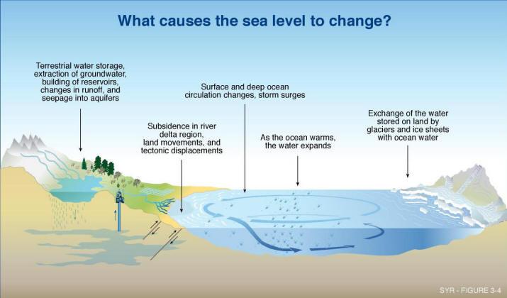
3 Sea Level has Changed Throughout Geologic History
4

5 1.7mm/year 2.9mm/year

6 Past, Present, and Future Forecasts Historic Proxies Gage Data Satellites NTS: Average Height of US Male = 5 10
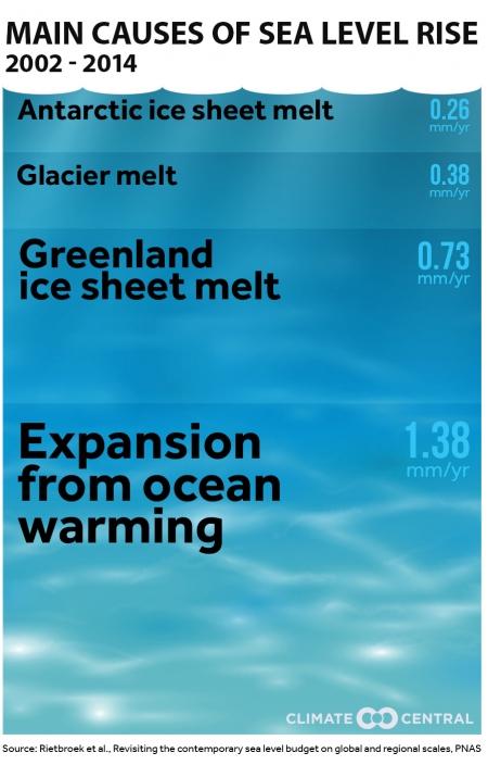
7 Literature Review Sea Level Rise (meters) IPCC Estimates IPCC (2001, 2007, and 2013) acknowledge that there is an unknown additional potential contribution from major ice sheets that is not included in 0.96 the range shown here NRC IPCC IPCC IPCC 2013 Rahmstorf 2007 Horton 2008 Pfeffer 2008 Vermeer 2009 Jevrejeva 2010 Katsman 2011 NRC NOAA 2012 USACE 2013


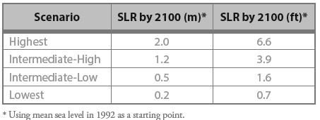
8 Global Sea Level Rise Scenarios for the United States National Climate Assessment

9 Consensus Scenarios that fed the NCA 3 rd Assessment Major Ice Melt Moderate Ice Melt Today Ocean Warming Extrapolation

10 Greatest source of uncertainty? Source: NASA
11 SCENARIOS ARE trajectories of environmental change for the purpose of risk and vulnerability assessment to inform the development of robust adaptation options ARE NOT predictions or projections of what will happen ARE NOT formed under the assumption of reducing uncertainty


12 Why use multiple scenarios? Source: Global Business Network Weeks et al 2011

13 A Decision Analogy Tomorrow there is a chance of rain, but what do you have planned for tomorrow?


14 Why such a large scenario range? Higher risk tolerance: Greater flexibility to accommodate flooding Lower consequence Ability to change in near term Lower risk tolerance: Little flexibility to accommodate flooding Higher consequence Inability to change in near term

15 Sea Level is Not Rising at the Same Rate Everywhere


16 Land Motion Plays a Big Part Too
17 Local Sea Level Rise The mean sea level trend is 3.15 millimeters/year with a 95% confidence interval of +/ mm/yr based on monthly mean sea level data from 1921 to 2006 which is equivalent to a change of 1.03 feet in 100 years.
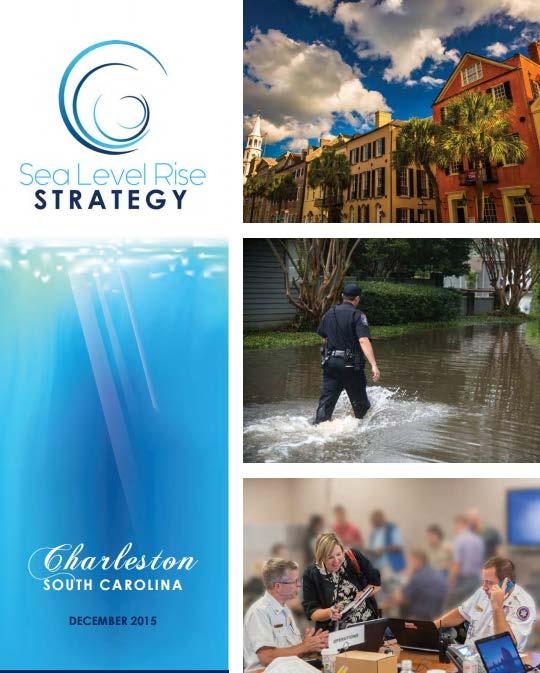
18 Local Projections - Charleston

19 Selecting a SLR Scenario (example) A 1.5 foot increase will be used for short-term, less vulnerable investment, such as a parking lot. A 2.5 foot increase will be used for more critical longer term investments, such as emergency routes and public buildings. From City of Charleston Sea Level Rise Strategy Document

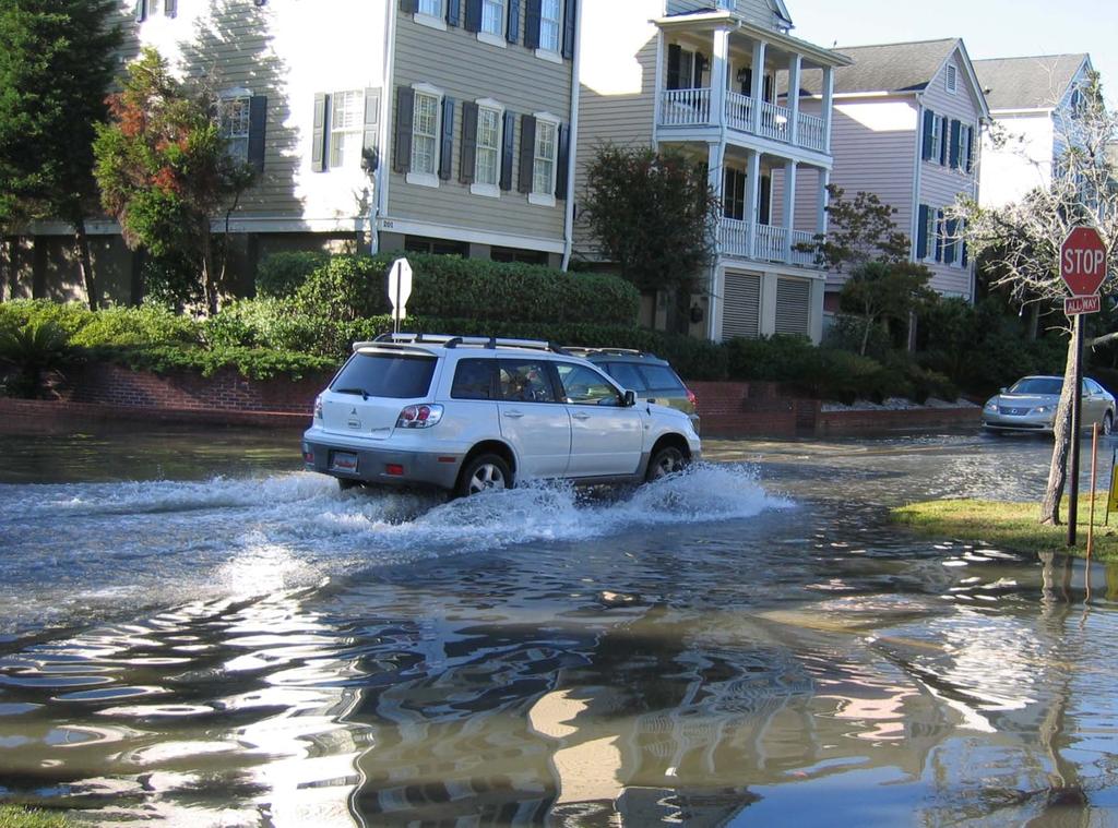
20 Critical Thresholds Are Being Reached More Often

21 Recent High Tide Events
22

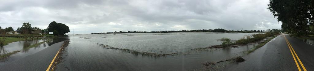
23 Nuisance Flooding

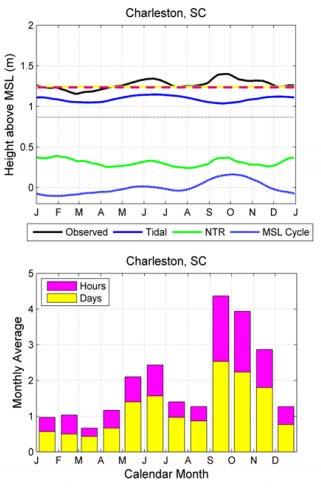
24 Anomaly In October

25 Add Rain and You Get Worse Flooding


26 Stormwater 101 Low Tide High Tide

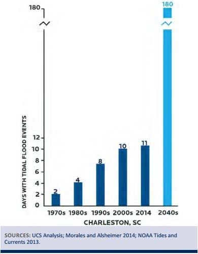
27 Increase in Events

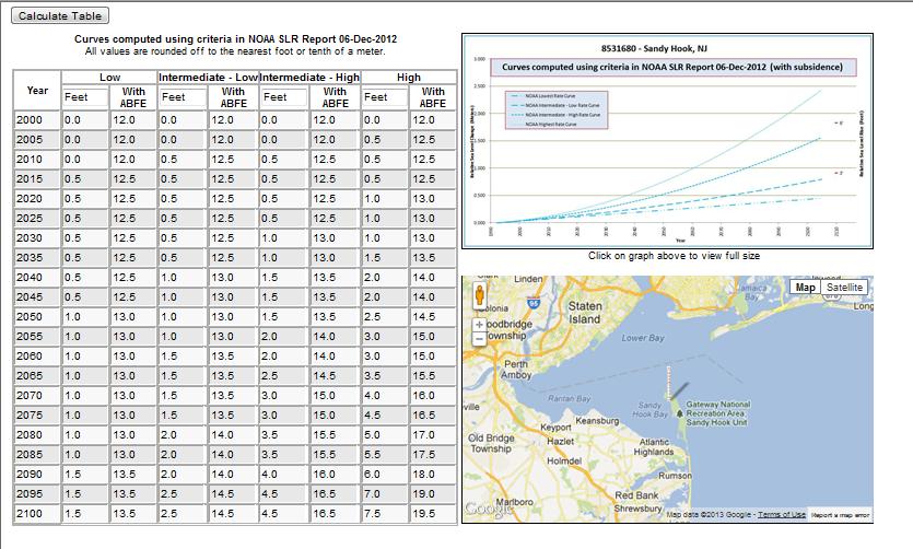
28 Top Ten U.S. Areas with an Increase in Nuisance Flooding Nuisance level : Meters above mean higher high water mark Average nuisance flood days, Average nuisance flood days, Percent Increase Annapolis, Md. Baltimore, Md. Atlantic City, N.J. Philadelphia, Pa. Sandy Hook, N.J. Port Isabel, Texas Charleston, S.C. Washington, D.C. San Francisco, Calif /29/ :56 am Tide at Charleston Gauge 7.2' (observed) Mycoast.org/SC es2014/ _nuisanceflooding. html Norfolk, Va


29 10/29/ :25 am Tide at Charleston Gauge 7.4' (observed) Mycoast.org/SC ov/stories2014/ _sea levelrise.html


30 We Are One of the Poster Children human-caused-coastal-flooding

31 Documenting King Tides

32 What Are We Going To Do?

33 The Stage has Been Set to Look at Future July 2012 Oct 2012 Dec 2012 Spring 2013 Early June 2013 June 2013 Aug 2013 Spring 2014 March 2015 Flood Risks Biggert-Waters Flood Reform Bill Reestablishment of TMAC Hurricane Sandy Sea Level Rise Scenario Consensus Updating Old Flood Risk Maps New Tools to Visualize Future Flood Risk President s Climate Action Plan Sandy Rebuilding Taskforce Federal Flood Risk Management Standard Climate Data Initiative and Climate Resilience Toolkit coast.noaa.gov

.")
34 Hurricane Sandy Turning Point? Places in NJ and NY experienced 6-7 ft of inundation above ground level. At the Battery in New York City, Sandy was estimated to be over a 1600 year event (less than % chance annually). Sandy was the second most costly hurricane to hit the U.S. (Katrina was first).

35 New Tools To Visualize and Compute Flood Risk Sea Level Rise Tool For Sandy Recovery DEMO
36 Usable science supports choices, actions The SLR Tool for Sandy Recovery was used for: 16 local laws in 2013 Natural Hazard Mitigation Plan Multi-purpose levee in Lower Manhattan Beach replenishment and dune construction Restored wetlands and a tidal barrier in Coney Island Creek ConEd rate case

37 Mapping Future Conditions Recommendation 3: Provide flood hazard products and information for coastal and Great Lakes areas that include the future effects of long-term erosion and sea/lake level rise. Major elements are: Provide guidance and standards for the development of future conditions coastal flood hazard and risk products. Incorporate local relative sea/lake level rise scenarios and long-term coastal erosion into coastal flood hazard analyses. Consider the range of potential future natural and manmade coastal changes, such as inundation and coastal erosion.
 using bestavailable, actionable climate science, and considering other factors affecting flood risk, the investment lifetime, and the action s criticality")
38 FFRMS Elevation and Floodplain Agencies select one of three approaches: 1. A Climate-Informed Science Approach (CISA) using bestavailable, actionable climate science, and considering other factors affecting flood risk, the investment lifetime, and the action s criticality (preferred approach where data are available) 2. Freeboard above BFE of 2 feet (standard actions) or 3 feet (critical actions) Percent-Annual-Chance (500-year) flood elevation

39 New DFIRMs
40 It s About Time! Congress has given FEMA the authority to start to evaluate how to incorporate future flood risk Recommendations have been made by TMAC Federal guidance on future global sea level rise now exists more coming New Federal investments will require a higher flood standard Agencies are developing guidance for taking into account climate change/slr (ex. DOT, USACE, DOD, EPA) Going above and beyond the current regulations and standards is now considered a best practice. Communities want to build from disasters stronger and smarter and are looking for tools and guidance for future flooding (and we are working on them).


41 Sea Level Rise and Coastal Flooding Impacts Viewer coast.noaa.gov/digitalcoast/tools/slr Displays potential future sea levels Provides simulations of sea level rise at local landmarks Communicates the spatial uncertainty of mapped sea levels Models potential marsh migration due to sea level rise Overlays social and economic data onto potential sea level rise Examines how tidal flooding will become more frequent with sea level rise
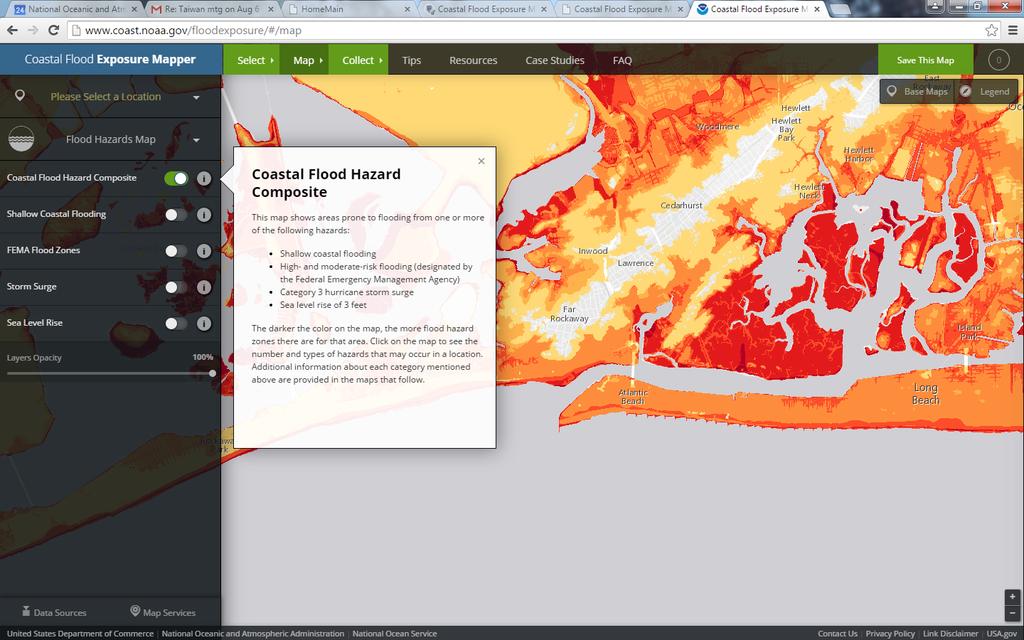
42 Coastal Flood Exposure Mapper coast.noaa.gov/digitalcoast/tools/flood-exposure

43 Steps to Resilience 1. Focus on climate stressors that threaten people, buildings, natural resources, or the economy in your area. 2. Identify specific populations, locations, and infrastructure that may be impacted by the climate problem you identified. 3. Compile a list of potential solutions, drawing on the experiences of others who have addressed similar problems. 4. Consider risks and values to analyze the costs and benefits of favored options. Select the best solution for your situation and make a plan. 5. Implement your plan and monitor your progress. As necessary, adjust your plan to move toward your desired outcomes. Be prepared to iterate, if needed. From U.S. Climate Resilience Toolkit toolkit.climate.gov


44 Robustness vs. Resilience Robust systems, designs, and projects are sturdy (Gray Infrastructure). They function and perform within specifications regardless of externals stressors. External stressors are absorbed or deflected without internal change. Resilient systems, designs, and projects adapt, adjust, and change in response to internal and external stressors (Green Infrastructure) They have response gradients and thresholds or tipping point. Their performance may shift to alternate states or regimes

45 Future Strategy for Charleston

46 Future Strategy for Charleston
47 Questions? Doug Marcy Russell Jackson
Sea Level Rise and the NFIP
 Cheryl A Johnson, PE, CFM, PMP March 26, 2014 http://www.globalchange.gov/ Sea-level rise and the likely increase in hurricane intensity and associated storm surge will be among the most serious consequences
Accounting for Long-Term Erosion and Sea Level Rise in New England: A TMAC Recommendation
 Accounting for Long-Term Erosion and Sea Level Rise in New England: A TMAC Recommendation Elena Drei-Horgan, PhD, CFM Jeremy Mull, PE Brian Caufield, PE May 2017 Establishment of TMAC, Definition, Members
Adaptation Practices and Lessons Learned
 Adaptation Practices and Lessons Learned Increased Flooding Risk Due To Sea Level Rise in Hampton Roads: A Forum to Address Concerns, Best Practices and Plans for Adaptation Nov. 16, 2012 Virginia Modeling,
Coastal Vulnerability Assessment and Adaptation Plan CITY OF CLEARWATER
 Coastal Vulnerability Assessment and Adaptation Plan 1 Background Vulnerability Assessment Adaptation Plan Peril of Flood Grant 2 Background SEA LEVEL RISE ADAPTATION PROJECT This publication was funded
Flood Risk and Climate Adaptation: Policy Reforms and Lessons (Being) Learned from Hurricane Sandy
 Learned from Hurricane Sandy") Flood Risk and Climate Adaptation: Policy Reforms and Lessons (Being) Learned from Hurricane Sandy Adaptive Planning For Coastal Change: Legal Issues For Local Government Briefing Overview 2 Background:
Flood Risk and Climate Adaptation: Policy Reforms and Lessons (Being) Learned from Hurricane Sandy Adaptive Planning For Coastal Change: Legal Issues For Local Government Briefing Overview 2 Background:
Decision-makers Barriers to Climate and Extreme Weather Adaptation for Seaports
 Decision-makers Barriers to Climate and Extreme Weather Adaptation for Seaports ELIZABETH L MCLEAN, PHD AUSTIN BECKER, PHD DUNCAN MCINTOSH, PHD DEPARTMENT OF MARINE AFFAIRS UNIVERSITY OF RHODE ISLAND Chris
Moving Policy and Practice from Flood and Coastal Storm Damage Reduction to Risk Management
 Moving Policy and Practice from Flood and Coastal Storm Damage Reduction to Risk Management and other words of encouragement for my friends in the Planning CoP Eric Halpin, PE Special Assistant for Dam
North Atlantic Coast Comprehensive Study: Resilient Adaption to Increasing Risk
 North Atlantic Coast Comprehensive Study: Resilient Adaption to Increasing Risk U.S. Army Corps of Engineers Coastal Storm Risk Management Planning Center of Expertise Amy M. Guise, USACE 21 November 2013
ADVISORY BASE FLOOD ELEVATIONS (ABFEs)
") The Department of Homeland Security s Federal Emergency Management Agency is committed to helping communities that were impacted by Hurricanes Katrina and Rita rebuild safer and stronger. Following catastrophic
The Department of Homeland Security s Federal Emergency Management Agency is committed to helping communities that were impacted by Hurricanes Katrina and Rita rebuild safer and stronger. Following catastrophic
Primer on Executive Order 11988: Floodplain Management
 Primer on Executive Order 11988: Floodplain Management There are new floodplain management requirements as a result of Executive Order 11988 and the expanded floodplain definition under Executive Order
Recovery Efforts and Legal Issues. Caroline Karp. Senior Lecturer Brown University
 Recovery Efforts and Legal Issues Caroline Karp Senior Lecturer Brown University When retreat is the better part of valor: Analysis of (Some) Strategies to Incentivize Retreat from the Shore EBC/RISEP
Executive Director Deputy Director Director Emeritus Chad M. Berginnis, CFM Ingrid D. Wadsworth, CFM Larry A. Larson, P.E., CFM
 ASSOCIATION OF STATE FLOODPLAIN MANAGERS, INC. 575 D Onofrio Drive, Suite 200, Madison, Wisconsin 53719 www.floods.org Phone: 608-828-3000 Fax: 608-828-6319 asfpm@floods.org www.floods.org Executive Director
Aquidneck Island Resilience Strategy Issue Paper 4. Issue: RESIDENTIAL FLOODING
 Aquidneck Island Resilience Strategy Issue Paper 4 Issue: RESIDENTIAL FLOODING Description of Concern: While much of Aquidneck Island s geography lies outside the reach of coastal flooding, some of the
ASFPM Update OUR CHALLENGE. Floods are 'acts of God,' but flood losses are largely acts of man. Fall, 2016
 ASFPM Update Fall, 2016 OUR CHALLENGE Floods are 'acts of God,' but flood losses are largely acts of man. 1945 PhD Dissertation Human Adjustments to Flood by Gilbert F. White 1 OUR CHALLENGE Credit: Chopperguy
Adapting Maine s coastal communities to sea level rise and storm surge (2015 State of the Bay Presentation)
") University of Southern Maine USM Digital Commons Presentations Casco Bay Estuary Partnership (CBEP) 2015 Adapting Maine s coastal communities to sea level rise and storm surge (2015 State of the Bay Presentation)
University of Southern Maine USM Digital Commons Presentations Casco Bay Estuary Partnership (CBEP) 2015 Adapting Maine s coastal communities to sea level rise and storm surge (2015 State of the Bay Presentation)
2015 AWRA Summer Specialty Conference: Climate Change Adaptation (New Orleans, LA) June 15, 2015 Presenter: John Squerciati, P.E.
 June 15, 2015 Presenter: John Squerciati, P.E.") Economic Assessment Tools for Infrastructure Resilience Projects - FTA - Hazard Mitigation Cost Effectiveness (HMCE) Tool and Recurrence Interval Calculator for Benefit-Cost Analysis 2015 AWRA Summer Specialty
Economic Assessment Tools for Infrastructure Resilience Projects - FTA - Hazard Mitigation Cost Effectiveness (HMCE) Tool and Recurrence Interval Calculator for Benefit-Cost Analysis 2015 AWRA Summer Specialty
National Coastal Outreach
 National Coastal Outreach Answering Tough Questions June 11, 2013 Why Focus on Coastal Flood Risk? 120,475,000 people or 39% of the U.S. population live in counties subject to the 1% annual chance coastal
Reducing Coastal Risk
 Reducing Coastal Risk Committee on U.S. Army Corps of Engineers Water Resources Science, Engineering, and Planning: Coastal Risk Reduction National Research Council Rick Luettich, Committee Chair Committee
Climate Change Policy Update:
 Proud Platinum Sponsor of the ASFPM 2017 Annual Conference Climate Change Policy Update: Overview of Federal Agency Responses to Executive Order 13690 and the Federal Flood Risk Management Standard Dr.
Real Options as a Tool for Valuing Investments in Adaptation to Climate Change
 Real Options as a Tool for Valuing Investments in Adaptation to Climate Change Conference on Economics of Adaptation to Climate Change in Low-Income Countries 18 May 2011 Washington, DC Peter Linquiti
Ocean City Office of Emergency Management. Environmental Commission Lecture Series October 24, 2017
 Ocean City Office of Emergency Management Environmental Commission Lecture Series October 24, 2017 FEMA Region II Flood Insurance Rate Maps (FIRM s) Adopted as of 10/5/2017 All of Cape May County adopted
Sea-Level Rise: Science, Legal Issues, and Adaptation for. Florida Local Governments. Click to edit Master title style
 Sea-Level Rise: Science, Legal Issues, and Adaptation for Click to edit Master title style Florida Local Governments Click to edit Master subtitle style Daytona Beach May 22, 2015 Thomas Ruppert Coastal
Crediting Adaptation Strategies through the National Flood Insurance Program s Community Rating System Coordinator s Manual
 Crediting Adaptation Strategies through the National Flood Insurance Program s Community Rating System Coordinator s Manual W. Thomas Hawkins, Adjunct Faculty, University of Florida, Levin College of Law
Coastal Flood Insurance Studies in Virginia and Climate Change
 Coastal Flood Insurance Studies in Virginia and Climate Change VFMA Floodplain Management Workshop October 22, 2015 Jeff Gangai Why is a Coastal Restudy Needed? New Guidelines need to be implemented Atlantic
ASFPM Update. GAFM 10 th Annual Technical Conference March 24, 2016
 ASFPM Update GAFM 10 th Annual Technical Conference March 24, 2016 AND HE SAID Floods are 'acts of God,' but flood losses are largely acts of man. 1945 PhD Dissertation Human Adjustments to Flood by Gilbert
Huntington Beach LCPA 1-16 (Sunset Beach Specific Plan) DRAFT Hazard Analysis Sug Mod Working Document/Not for general circulation.
 DRAFT Hazard Analysis Sug Mod Working Document/Not for general circulation.") LCPA 1-16 (Sunset Beach Specific Plan) DRAFT Hazard Analysis Sug Mod Working Document/Not for general circulation. 3.3 Regulations (page 34) 3.3.9 (page 60) Add new Section 3.3.9 below after Flood Plain
LCPA 1-16 (Sunset Beach Specific Plan) DRAFT Hazard Analysis Sug Mod Working Document/Not for general circulation. 3.3 Regulations (page 34) 3.3.9 (page 60) Add new Section 3.3.9 below after Flood Plain
State Perspectives on Critical Water Issues: ASFPM Update NAFSMA Annual Meeting
 State Perspectives on Critical Water Issues: ASFPM Update 2016 NAFSMA Annual Meeting OUR CHALLENGE Floods are 'acts of God,' but flood losses are largely acts of man. 1945 PhD Dissertation Human Adjustments
TECHNICAL MAPPING ADVISORY COUNCIL TMAC FUTURE CONDITIONS REPORT INTERIM
 TECHNICAL MAPPING ADVISORY COUNCIL TMAC FUTURE CONDITIONS REPORT INTERIM October 2015 Table of Contents 1. Introduction... 1 1.1 Purpose... 1 1.2 Congressional Charter... 1 1.3 TMAC Responsibilities...
Action Items for Flood Risk Management on Wildcat Creek Interagency success with floodplain management plans and flood forecast inundation maps
 Presentation to USACE 2012 Flood Risk Management and Silver Jackets Joint Workshop, Harrisburg, Pennsylvania Action Items for Flood Risk Management on Wildcat Creek Interagency success with floodplain
September 8, RE: Application for Planned Unit Development and Special Exemption Permit by Bluff Point Holdings LLC
 September 8, 2011 Northumberland County Board of Supervisors P.O. Box 129 Heathsville, VA 22473 RE: Application for Planned Unit Development and Special Exemption Permit by Bluff Point Holdings LLC Dear
History of Floodplain Management in Ascension Parish
 History of Floodplain Management in Ascension Parish presented by: Kara Moree Floodplain Coordinator February 6, 2012 Floodplain 101 Floodplain 101 Base or 1% Flood: A flood having a 1% chance of being
More Legal Quick Takes: SLR, Law & Flooding
 More Legal Quick Takes: SLR, Law & Flooding Click to edit Master title style Click to edit Master subtitle style Erin Deady, President, Erin L. Deady, PA & Thomas Ruppert Coastal Planning Specialist, Florida
Biggert-Waters The Changing Script
 Biggert-Waters 2012 The Changing Script Policyholder Subsidies These policies are not Pre-FIRM subsidized (already actuarially rated), 4,480,669 policies. They are not affected by 205 but may see routine
Impact of Climate Change and Population Growth on the National Flood Insurance Program. Mark Crowell 2/26/2014
 Impact of Climate Change and Population Growth on the National Flood Insurance Program Mark Crowell 2/26/2014 1 2007 GAO Report Recommends FEMA analyze the potential long-term implications of climate change
INFORMED DECISIONS ON CATASTROPHE RISK
 ISSUE BRIEF INFORMED DECISIONS ON CATASTROPHE RISK Analysis of Flood Insurance Protection: The Case of the Rockaway Peninsula in New York City Summer 2013 The Rockaway Peninsula (RP) in New York City was
Delaware River Basin Commission s Role in Flood Loss Reduction Efforts
 Delaware River Basin Commission s Role in Flood Loss Reduction Efforts There is a strong need to reduce flood vulnerability and damages in the Delaware River Basin. This paper presents the ongoing role
THE NATIONAL FLOOD INSURANCE PROGRAM:
 THE NATIONAL FLOOD INSURANCE PROGRAM: Directions for Reform As Congress considers legislative changes to the debt-ridden National Flood Insurance Program, Carolyn Kousky discusses four key issues for reform.
Floodplain Management. Making the Case for a No Adverse Impact (NAI) Approach
 Approach") Floodplain Management Making the Case for a No Adverse Impact (NAI) Approach Options and Actions to Address Flood Insurance Affordability 2 Disclaimer This presentation is neither intended to be, nor may
Floodplain Management Making the Case for a No Adverse Impact (NAI) Approach Options and Actions to Address Flood Insurance Affordability 2 Disclaimer This presentation is neither intended to be, nor may
Orleans Parish, LA Initial Coordination Meeting Preliminary DFIRM Update September 29, 2011
 Orleans Parish, LA Initial Coordination Meeting Preliminary DFIRM Update September 29, 2011 Introductions Project History Description of Update Effort Project Benefits Project Schedule How You Can Help
Delaware Bay / River Coastal Flood Risk Study. FEMA REGION II and III September 19, 2012
 Delaware Bay / River Coastal Flood Risk Study FEMA REGION II and III September 19, 2012 Agenda Risk MAP Program Overview Risk MAP Non-Regulatory Products & Datasets Region II New Jersey Coastal Flood Study
Workshop Summary: Adaptation to Sea Level Rise Best Practices Village of Key Biscayne. Presented by: AECOM May 26, 2017
 Workshop Summary: Adaptation to Sea Level Rise Best Practices Village of Key Biscayne Presented by: AECOM May 26, 2017 Report Prepared June 23, 2017 Chapter 1 Introduction...1 Chapter 2 Flood Hazards...2
4 TH ANNUAL CAPE COASTAL CONFERENCE. Adaptation Planning, Environmental Economics and Community Engagement
 4 TH ANNUAL CAPE COASTAL CONFERENCE THE RESILIENT CAPE COD PROJECT Adaptation Planning, Environmental Economics and Community Engagement K r i s t y S e n a t o r i, Cape Cod Commission NOAA COASTAL RESILIENCY
COASTAL HAZARD MITIGATION TOOLS AND TECHNIQUES
 COASTAL HAZARD MITIGATION TOOLS AND TECHNIQUES Beach Nourishment Responsible Agency/Party: Mitigation for: Management Effort: Federal and/or State sponsored projects Long- and short-term erosion Flood
SILVER JACKETS: TEAMING TO MITIGATE AND MANAGE STATE FLOOD HAZARD PRIORITIES
 SILVER JACKETS: TEAMING TO MITIGATE AND MANAGE STATE FLOOD 255 255 255 237 237 237 0 0 0 217 217 217 163 163 163 200 200 200 131 132 122 239 65 53 80 119 27 HAZARD PRIORITIES 110 135 120 252 174.59 112
Climate Change Adaptation Plan for Choiseul Bay Township, Solomon Islands
 Climate Change Adaptation Plan for Choiseul Bay Township, Solomon Islands Dr Philip Haines and Ms Shannon McGuire Sustainable Engineering Society - Technical Session 17 March 2015 1 Presentation outline
Executive Summary Introduction and Study Context Cecil County s Floodplain Flood Measurement Flood Levels...
 Executive Summary... 2 Introduction and Study Context... 4 Cecil y s Floodplain... 4 Flood Measurement... 6 Flood Levels... 6 Hazards from Floods... 7 Flood Vulnerability Assessment... 9 Study Method...
BY BOB WOODS PLANNING TODAY FOR TOMORROW S TERRAY SYLVESTER / GETTY IMAGES
 BY BOB WOODS PLANNING TODAY FOR TOMORROW S TERRAY SYLVESTER / GETTY IMAGES As weather-related events such as hurricanes multiply and intensify, states and municipalities are recognizing the urgent need
GAFM Showcase: Multiple Agencies Combating Georgia s Flood Risk Together: Proven Results Gained by Strong Partnerships
 National Flood Insurance Program Participation GAFM Showcase: Multiple Agencies Combating Georgia s Flood Risk Together: Proven Results Gained by Strong Partnerships Moderator: Jill Bazinet, PE, CFM GAFM
Sandy + BW-12: Changing the Equation for Building Safer, More Resilient Communities
 Sandy + BW-12: Changing the Equation for Building Safer, More Resilient Communities Grant Smith Jerry Sparks Jean Huang Ken Logsdon Stephanie Routh Session Agenda Moderators: Grant Smith & Jerry Sparks
EXECUTIVE SUMMARY. Donald Leland Craig, AICP Director of Community Development Services
 EXECUTIVE SUMMARY To: Through: From: Jim Scholl, Interim City Manager Donald Leland Craig, AICP Director of Community Development Services Nicole Malo, AICP, LEED GA Planner II Meeting Date: July 1, 2014
Using GISWeb to Determine Your Property s Flood Zone
 Using GISWeb to Determine Your Property s Flood Zone 1. In a new browser window, go to http://www.co.santacruz.ca.us/departments/geographicinformationsystemsgis.aspx 2. Click on GISWeb - GIS Mapping Application
Improving Coordinated Flood Preparedness and Response
 Improving Coordinated Flood Preparedness and Response Illinois Silver Jackets Hank DeHaan Rock Island and Saint Louis Districts October 2011 US Army Corps of Engineers Illinois Silver Jackets Program Illinois
Bucks County, PA Flood Risk Review Meeting. November 2014
 Bucks County, PA Flood Risk Review Meeting November 2014 Agenda for Today Risk MAP Program overview Overview of non-regulatory Flood Risk Products and datasets Discuss mitigation action Technical overview
NFIP Program Basics. KAMM Regional Training
 NFIP Program Basics KAMM Regional Training Floodplain 101 Homeowners insurance does not cover flood damage Approximately 25,000 flood insurance policies in KY According to BW12 analysis, approximately
The COAST Approach to Adaptation Action for Sea Level Rise and Storm Surge. Samuel B. Merrill, PhD May 20, 2014
 The COAST Approach to Adaptation Action for Sea Level Rise and Storm Surge Samuel B. Merrill, PhD May 20, 2014 Fig. 3c-City of Portland: Commercial Street EastCOAST Model Results, 100 Year Storm in 2100
National Flood Insurance Program (NFIP) Community Rating System (CRS) Together North Jersey Resilient Task Force Meeting
 Community Rating System (CRS) Together North Jersey Resilient Task Force Meeting") National Flood Insurance Program (NFIP) Community Rating System (CRS) Together North Jersey Resilient Task Force Meeting April 3, 2017 Marianne Luhrs, AICP FEMA R2 CRS Coordinator Visual Intro-1 CRS Program
National Flood Insurance Program (NFIP) Community Rating System (CRS) Together North Jersey Resilient Task Force Meeting April 3, 2017 Marianne Luhrs, AICP FEMA R2 CRS Coordinator Visual Intro-1 CRS Program
The National Flood Insurance Program and Flood Insurance Rate Map for San Francisco. Presentation at Treasure Island Community Meeting
 The National Flood Insurance Program and Flood Insurance Rate Map for San Francisco Presentation at Treasure Island Community Meeting October 17, 2007 1 National Flood Insurance Program (NFIP) Overview
Community Resilience & NFIP s Community Rating system
 Community Resilience & NFIP s Community Rating system Ajita Atreya Wharton Risk Management and Decision Processes Center University of Pennsylvania National Association of Counties (NACo) Session on Risk
Building a Resilient Energy Gulf Coast: Executive Report
 Building a Resilient Energy Gulf Coast: Executive Report Summary http://americaswetland.com http://entergy.com/gulfcoastadaptation Over the past year, Entergy Corporation has worked to develop a framework
Making Good Decisions Under Uncertainty: A Learning By Doing Workshop
 During a 2008 panel for the IPCC s launch of a report on water and climate, a hydrologist and an engineer called for additional monitoring and research to understand the effects of climate change. The
Leveraging the Community Rating System for Climate Adaptation. Southeast and Caribbean Climate Community of Practice Webinar Series 23 March 2015
 Leveraging the Community Rating System for Climate Adaptation Southeast and Caribbean Climate Community of Practice Webinar Series 23 March 2015 Today s Speakers: Shana Jones, J.D., Carl Vinson Institute
Flood: How to Protect Your Business from a Natural Disaster
 Flood: How to Protect Your Business from a Natural Disaster Speakers: Greg Bates, Managing Consultant, Global Risk Consultants (GRC) Frank Francone, Manager, Insurance & Risk Services, General Growth Properties
3URMHFWHG,PSDFWRI 5HODWLYH6HD/HYHO5LVHRQWKH 1DWLRQDO)ORRG,QVXUDQFH3URJUDP
ORRG,QVXUDQFH3URJUDP") 3URMHFWHG,PSDFWRI 5HODWLYH6HD/HYHO5LVHRQWKH 1DWLRQDO)ORRG,QVXUDQFH3URJUDP October 1991 FEDERAL EMERGENCY MANAGEMENT AGENCY FEDERAL INSURANCE ADMINISTRATION Originally published October 1991 by the Federal
3URMHFWHG,PSDFWRI 5HODWLYH6HD/HYHO5LVHRQWKH 1DWLRQDO)ORRG,QVXUDQFH3URJUDP October 1991 FEDERAL EMERGENCY MANAGEMENT AGENCY FEDERAL INSURANCE ADMINISTRATION Originally published October 1991 by the Federal
Facts & Info regarding the NFIP in Mathews County VA And the Mathews County Floodplain Management Ordinance
 Facts & Info regarding the NFIP in Mathews County VA And the Mathews County Floodplain Management Ordinance As of 05-31-2014: Current NFIP policies in Mathews County = 1687 NFIP Claims= 1127, for a total
Appendix F. Asset Categorization and Classification Report. Draft
 Appendix F Asset Report Appendix F: Asset Report Imagine the result Vulnerability Assessment September 22, 2015 Table of Contents 1. Introduction 1 1.1 Purpose 2 1.2 Definitions and Background 2 2. Approach
Floodplain Management 101. Mississippi Emergency Management Agency Floodplain Management Bureau
 Floodplain Management 101 Mississippi Emergency Management Agency Floodplain Management Bureau Stafford Act The Stafford Disaster Relief and Emergency Assistance Act (Stafford Act) (Public Law 100-707)
Introduction Preparation of a Community Reconstruction Zone Plan
 Guidance for Community Reconstruction Zone Plans A Planning Toolkit for CRZ Planning Committees Table of Contents Introduction.............................................. 1 Preparation of a Community
Erie County Flood Risk Review Meeting. January 18, 2018
 Erie County Flood Risk Review Meeting January 18, 2018 Agenda The value of updated flood maps for your community Review updated flood-risk data and important next steps in the Risk MAP process Increasing
King County Flood Control District Flood Risk Reduction Work Program and Accomplishments
 King County Flood Control District Flood Risk Reduction Work Program and Accomplishments Brian Murray Water and Land Resources Division April 26, 2016 Department of Natural Resources and Parks Water and
Helping communities weather the storm. Shawna Peddle Adaptation Canada 2016 April 13, 2016
 Helping communities weather the storm Shawna Peddle Adaptation Canada 2016 April 13, 2016 FLOOD HAPPENS Our climate is changing Increasing precipitation, snow and ice melt Our communities are changing
Riverine Flooding - Cedar Rapids, Iowa 2008
 Katrina 2005 Riverine Flooding - Cedar Rapids, Iowa 2008 Riverine and Pluvial Flooding Nashville 2010 Mississippi and Missouri Rivers 2011 INFRASTRUCTURE ECONOMY 21 st Century 20 th Century "Toto, I've
Kevin Wagner Maryland Department of the Environment
 Kevin Wagner Maryland Department of the Environment Topics Overview of the National Flood Insurance Program (NFIP) Mapping Regulations Insurance Mitigation Community Rating System (CRS) Questions Know
ASFPM Partnerships for Statewide Mitigation Actions. Alicia Williams GIS and HMP Section Manager, Amec Foster Wheeler June 2016
 ASFPM Partnerships for Statewide Mitigation Actions Alicia Williams GIS and HMP Section Manager, Amec Foster Wheeler June 2016 Summary The Concept Leveraging Existing Data and Partnerships to reduce risk
Coastal Flood Maps. Chris Penney. Program Manager USACE Baltimore District 2 June US Army Corps of Engineers BUILDING STRONG
 Coastal Flood Maps Chris Penney Program Manager USACE Baltimore District 2 June 2015 US Army Corps of Engineers There are two types of coastal flood risk maps They look different They communicate different
North Atlantic Coast Comprehensive Study Visioning Meetings Summary
 North Atlantic Coast Comprehensive Study Visioning Meetings Summary FINAL Report June 2014 Submitted by: CDM Smith 50 Hampshire Street Cambridge, MA 02139 A Report Submitted to: U.S. Army Corps of Engineers
Rainy Days and Hot Summer Nights: Planning for Hazards in a Changing Climate
 BREAKING GROUND 2015 Building Livable Communities in Greater Philadelphia: The Next 50 Years The Union League of Philadelphia Philadelphia, Pa. March 12, 2015 Rainy Days and Hot Summer Nights: Planning
BRANDI GABBARD CHAIR, NATIONAL ASSOCIATION OF REALTORS INSURANCE COMMITTEE COUNCIL MEMBER, CITY OF ST. PETERSBURG, FL
 BUILDING CLIMATE RESILIENCE IN THE REAL ESTATE SECTOR BRANDI GABBARD CHAIR, NATIONAL ASSOCIATION OF REALTORS INSURANCE COMMITTEE COUNCIL MEMBER, CITY OF ST. PETERSBURG, FL RESILIENCY THE ABILITY TO PREPARE
JOINT STUDY ON FLOOD ELEVATIONS AND BUILDING HEIGHT REQUIREMENTS PURSUANT TO 2015 N.C. SESS. LAW 286. Presented by:
 JOINT STUDY ON FLOOD ELEVATIONS AND BUILDING HEIGHT REQUIREMENTS PURSUANT TO 2015 N.C. SESS. LAW 286 Presented by: Dan H. Tingen Chairman of the North Carolina Building Code Council Rick McIntyre North
Institutional and Other Barriers Report PAGE INTENTIONALLY LEFT BLANK
 7 PAGE INTENTIONALLY LEFT BLANK North Atlantic Coast Comprehensive Study (NACCS) INSTITUTIONAL AND OTHER BARRIERS REPORT NORTH ATLANTIC COAST COMPREHENSIVE STUDY North Atlantic Coast Comprehensive Study
Living with levees: using tolerable risk guidelines in California
 Living with levees: using tolerable risk guidelines in California Jessica Ludy, CFM. Arcadis-U.S. Inc. Larry Roth, G.E., P.E., Arcadis-US, Inc. Dustin Jones, P.E., Delta Stewardship Council 1 Hoogwater
National Capitol Region HAZUS User Group Call
 Listen to the recording here to follow along with the presentation: http://www.freeconferencecalling.com/recordings/recording.aspx?fileid=l AF3494_04252013070630062_1154707&bridge=697620&email=&account
Integrating Hazard Mitigation and Comprehensive Planning Workshop
 Delaware Valley Regional Planning Commission Philadelphia, PA April 25, 2016 12:30 p.m. Integrating Hazard Mitigation and Comprehensive Planning Workshop Stephen D. Marks Municipal Manager City of Hoboken,
Floodplain Management Services Baltimore District Studies
 Floodplain Management Services Baltimore District Studies FACT SHEET as of December 31, 2014 AUTHORIZATION: Floodplain Management Services (FPMS) TYPE OF PROJECT: Flood Risk Management (Technical Services)
N.C. Floodplain Mapping Program
 N.C. Floodplain Mapping Program Current Status and Update April 23, 2018 NCFMP Program Objectives Purpose: Develop, Maintain, and Disseminate current, accurate, digital flood hazard data for all of NC,
Risk, Mitigation, & Planning
 Risk, Mitigation, & Planning Lessons from Flooding in the Houston Area Russell Blessing, Samuel Brody & Wesley Highfield CUMULATIVE FLOOD LOSS: 1972-2015 INSURED FLOOD LOSS: 1972-2015 THE HOUSTON-GALVESTON
Position Statement on a 2018 Water Resources Development Act (WRDA)
") Position Statement on a 2018 Water Resources Development Act (WRDA) In order to maintain the safety and resilience of our nation s coastlines, Congress must continue a twoyear cycle for passing Water Resource
Position Statement on a 2018 Water Resources Development Act (WRDA) In order to maintain the safety and resilience of our nation s coastlines, Congress must continue a twoyear cycle for passing Water Resource
G318 Local Mitigation Planning Workshop. Module 2: Risk Assessment. Visual 2.0
 G318 Local Mitigation Planning Workshop Module 2: Risk Assessment Visual 2.0 Unit 1 Risk Assessment Visual 2.1 Risk Assessment Process that collects information and assigns values to risks to: Identify
NFIP Mapping Issues. Wendy Lathrop, PLS, CFM. Cadastral Consulting, LLC
 NFIP Mapping Issues Cadastral Consulting, LLC NFIP Basic Objectives: Reduce the exposure to flood damages through the use of minimum standards for the placement and design of structures located in flood
HOW PLANNING FOR SEA LEVEL RISE CREATES FLOOD INSURANCE REDUCTIONS: THE GEORGIA CONTEXT. Hunter Jones 1 I. INTRODUCTION
 HOW PLANNING FOR SEA LEVEL RISE CREATES FLOOD INSURANCE REDUCTIONS: THE GEORGIA CONTEXT Hunter Jones 1 I. INTRODUCTION Flood insurance rates are rising for homeowners. One way local governments can create
Disaster Insurance: Are States and Insurance Companies Prepared?
 Disaster Insurance: Are States and Insurance Companies Prepared? National Conference of State Legislatures 2015 Legislative Summit Roy Wright Deputy Associate Administrator for Insurance and Mitigation
Changes to the National Flood Insurance Program What to Expect
 Changes to the National Flood Insurance Program What to Expect Impact of changes to the NFIP under Homeowner Flood Insurance Affordability Act of 2014 More Changes are Coming to the NFIP On March 21, 2014,
Risk Based Approaches for Levees in the U.S. and Abroad: Lessons for the NFIP
 Proud Platinum Sponsor of the ASFPM 2017 Annual Conference Risk Based Approaches for Levees in the U.S. and Abroad: Lessons for the NFIP Mike Seering (AECOM) David Powers (HR Wallingford) ASFPM 2017 Annual
On March 21, 2014, President Obama signed the Homeowner Flood Insurance Affordability Act of 2014 into law.
 On March 21, 2014, President Obama signed the Homeowner Flood Insurance Affordability Act of 2014 into law. This law repeals and modifies certain provisions of the Biggert-Waters Flood Insurance Reform
National Flood Insurance Program (NFIP) and Flood Insurance Rate Map (FIRM) San Francisco Port Commission. October 23, 2007
 and Flood Insurance Rate Map (FIRM) San Francisco Port Commission. October 23, 2007") National Flood Insurance Program (NFIP) and Flood Insurance Rate Map (FIRM) San Francisco Port Commission October 23, 2007 Flood Insurance Rate Map (FIRM) FEMA manages the NFIP using a nationwide system
National Flood Insurance Program (NFIP) and Flood Insurance Rate Map (FIRM) San Francisco Port Commission October 23, 2007 Flood Insurance Rate Map (FIRM) FEMA manages the NFIP using a nationwide system
Resilient Coasts: A Blueprint for Action
 Resilient Coasts: A Blueprint for Action The Resilient Coasts Blueprint was authored and endorsed by the following organizations: Risk Management Solutions The Resilient Coasts Initiative was made possible
Changes Coming to the National Flood Insurance Program What to Expect. Impact of changes to the NFIP under Section 205 of the Biggert-Waters Act
 Changes Coming to the National Flood Insurance Program What to Expect Impact of changes to the NFIP under Section 205 of the Biggert-Waters Act Flood Risk Flood risks and the costs of flooding Weather
Hurricane Katrina 10 th Anniversary Test
 Hurricane Katrina 10 th Anniversary Test New Orleans Item Friday September 19, 1947 Bob Jacobsen PE, LLC Coastal Hydrologist June 2015 About the Author Raised in Metairie; family still lives in home they
The Changing NFIP, the CRS & Local Governments. Scott Pippin, J.D., M.E.P.D.
 The Changing NFIP, the CRS & Local Governments Scott Pippin, J.D., M.E.P.D. Flood Insurance Reform Biggert Waters 2012 (BW12) Homeowner Flood Insurance Affordability Act of 2014 (HFIAA) Bigger Waters 2012
ASFPM RECOMMENDED TASK FORCE ACTIONS
 Association of State Floodplain Managers, Inc. 2809 Fish Hatchery Road, Suite 204, Madison, WI 53713 Phone: 608-274-0123 Fax: 608-274-0696 Website: www.floods.org Email: asfpm@floods.org Federal Interagency
Flood Smart Communities
 Flood Smart Communities Stevie Adams, Freshwater Specialist, The Nature Conservancy Funding provided by NOAA Coastal Storms Program through Ohio Sea Grant To conserve the lands and waters on which all