Michael Taylor, PE, CFM Project Manager, AECOM August 25, 2015
|
|
|
- Beverly Gregory
- 5 years ago
- Views:
Transcription


1 Promoting FEMA s Flood Risk Products in the Lower Levisa Watershed Michael Taylor, PE, CFM Project Manager, AECOM August 25, 2015


2 Agenda Study Background Flood Risk Product Overview AOMI and Mitigation Plan Flood Risk Product Rollout Conclusions Wayland, Kentucky, 1937


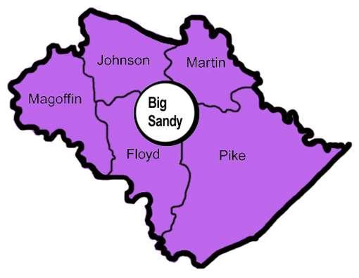
3 Lower Levisa Watershed Floyd County Johnson County Knott County Lawrence County Magoffin County Morgan County Pike County

4 Risk MAP Project Overview Detailed Studies 82 miles Approximate Studies 617 miles Redelineation 207 miles Effective Date September 16, 2015
5 Revised FIRM Panel Breakdown County Number of Revised Panels Floyd 49 Johnson 32 Knott 5 Lawrence 18 Magoffin 5 Morgan 4 Pike 31

6 Flood Risk Datasets and Products Flood Risk Datasets Changes Since Last FIRM Flood Depth & Analysis Grids Flood Risk Assessment Areas of Mitigation Interest Flood Risk Products Flood Risk Database Flood Risk Report Flood Risk Map
7 Purpose of Flood Depth & Analysis Grids Show flood inundation as a function of an event s magnitude or severity Show that flood risk varies within the floodplain Demonstrate the risks associated with different flood depths and probabilities Serve as key inputs to HAZUS Risk Assessment Analyses Can be used as pre-screening criteria for mitigation project potential Benefit Cost Analysis in 1% annual chance floodplain Acquisition of structures less than $276,000 Elevation of structures costing less than $175,000

8 1% Annual Chance Depth Grid

9 Percent Annual Chance Grid

10 Percent Chance of Flooding Over 30-Year Period Grid Legend pct30yrchance Value High : Low :

11 Potential Uses for Depth & Analysis Grids Informs decisions on risk reduction efforts Zero in on your areas of greatest flood risk vulnerability Clear depiction of high flood risk areas for future planning Inform future development decisions Understanding current and future risk Multiple datasets help visualize a variety of flood risk elements for local stakeholders Demonstrating higher flood vulnerability in specific areas Accessible source of data for cost-effectiveness Assists with advanced recovery planning and disaster preparedness
 Study Data Refined HAZUS and Other Risk Analyses Data")
12 Flood Risk Assessment Datasets Flood Risk Assessment Data 2010 HAZUS Average Annualized Loss (AAL) Study Data Refined HAZUS and Other Risk Analyses Data Composite Data
13 Flood Risk Assessment Data Purpose and Uses Quantifies flood risk in dollars: Residential Loss Commercial Loss Other Asset Loss Percent Damage Evaluates Building Stock Structure and Content Considerations Identifies areas of relative flood risk: Floodprone areas Vulnerable people and property Identification of Business Disruption: Considers Total Occupancy Tables Considers Lost Income and Wages Helps estimate potential losses (Risk, Very Low to Very High) due to flood risk: Classification (Residential, Commercial, Other) Average Value (buildings/census block) Population Total Loss Building/Content Loss
 Other Government Agency Data Claims data (RL, SRL, etc.")
14 Areas of Mitigation Interest Sources of Data Community Provided Data Interviews and questionnaire from Discovery Meeting Mining of existing mitigation plans Engineering Data Review of existing H&H models Engineering data from other reports (USACE, DOT, etc.) Other Government Agency Data Claims data (RL, SRL, etc.) CNMS data Flood control structures


15 Areas of Mitigation Interest Examples that may have an impact on the identified flood hazards or flood risks: Dams / Levees Stream flow constriction Past claims hot spots Essential facilities
16 Purpose of Areas of Mitigation Interest Provides input to local mitigation plans Identifies areas that may be affecting flood risk that would benefit from raised local awareness Raises awareness of local stakeholders within and upstream of the watershed that may be contributing to flood risk Identify Mitigate Resilience Assess Communicate
17 Hazard Mitigation Plans
18 Mitigation Goals from the Big Sandy ADD Hazard Mitigation Plan 1. Increase understanding and awareness of natural hazards 2. Identify and prioritize most vulnerable areas 3. Implement regulatory actions and policies for prevention 4. Protect critical facilities 5. Maximize partnerships to improve coordination and communication 6. Develop time frames and cost estimates for implementing mitigation actions including funding mechanisms
19 Lower Levisa Specific Products Structures in the 10% annual chance floodplain Over 3900 identified!

20 Lower Levisa Specific Products Stream constrictions or pinch points Structure Inventory

21 Resilience Meetings Paintsville, KY Prestonsburg, KY Pikeville, KY August 13-14, 2014

22 Reducing Your Flood Risk Develop a strategy Identify needs What types of projects does your community need? Flood hazard reduction Flood risk reduction Policy Prioritize your needs Cost Schedule Identify partners Find a champion
23 Taking Action Hazard Reduction o Bridge o Culvert o Dams o Debris o Drainage Improvements o Levees o Forest or Vegetation Management o Natural Systems Restoration o Soil Stabilization or Erosion Control Risk Reduction o Acquisition o Elevation o Structure o Utilities o Retrofit o Safe Room Construction o Underground Utilities Policy o Floodplain Management o Open Space Preservation o Stormwater Management o Subdivision Ordinance o Zoning o Building and Residential Codes o Community Rating System (CRS) o Natural Hazards Planning o Firewise o NFIP

24 Community Rating System Community CRS Rating Policy Discount Pike County 9 5% City of Pikeville 9 5% City of Paintsville 9 5%


25 FEMA Funding Opportunities Hazard Mitigation Assistance includes both post-disaster and pre-disaster grants HMGP is a post-disaster grant program. PDM and FMA are available annually, subject to Congressional appropriations. Mitigation Plan Requirement Local/State Cost Share States Manage Programs and Set Funding Priorities State Hazard Mitigation Officer (SHMO) is contact


26 Other Federal Agency Programs

27 Coal Run Village
28 Unique Challenges in the Lower Levisa Watershed that Required Further Coordination Floyd County was not updated during Map Modernization and was being studied up to the 1 square mile drainage area for the first time The City of Prestonsburg was largely moving from a high risk zone to a moderate risk zone; many rural areas moving from low risk zone to moderate risk zone Some communities needed special attention and/or follow-up meetings to integrate digital data into GIS platform Changes in the political environment initially impacted product buy-in


29 Additional Outreach in Floyd County Open House Meetings
30 Open House Meeting Setup

31 Additional Outreach in Floyd County - Handouts


32 Additional Outreach in Floyd County - Handouts

33 Additional Outreach in Floyd County - Training
34 Lessons Learned, Challenges, Recommendations Identify watershed-specific issues and concerns Develop a strategy for risk awareness and mitigation actions Continued coordination with watershed stakeholders Our work doesn t end with effective maps Involvement with the next HMP Update Making sure communities understand Flood Risk Product benefits and how to use them as tools Continued education on CRS and higher standards in order to reduce risk and flood insurance premium costs


35 Questions? Michael Taylor, PE, CFM
Non Regulatory Risk MAP Products Flood Depth and Probability Grids
 Non Regulatory Risk MAP Products Flood Depth and Probability Grids Virginia Floodplain Management Association 2015 Floodplain Management Workshop October 29th, 2015 Nabil Ghalayini, P.E., PMP, D.WRE, CFM
Kentucky Risk MAP It s not Map Mod II
 Kentucky Risk MAP It s not Map Mod II Risk Mapping Assessment and Planning Carey Johnson Kentucky Division of Water carey.johnson@ky.gov What is Risk MAP? Risk Mapping, Assessment, and Planning (Risk MAP)
Discovery Meeting: Middle Potomac- Catoctin Watershed. FEMA REGION III September 26, 2012 Rockville, MD and Fairfax, VA
 Discovery Meeting: Middle Potomac- Catoctin Watershed FEMA REGION III September 26, 2012 Rockville, MD and Fairfax, VA Agenda Introductions Purpose of This Meeting Discovery Process Community Rating System
Use of FEMA Non regulatory Flood Risk Products in Planning
 Use of FEMA Non regulatory Flood Risk Products in Planning Georgia Association of Floodplain Managers Annual Conference March 24, 2016 What are the Non regulatory Flood Risk products? Go beyond the basic
Findings/Debrief Meeting September 9, CDOT R4 Headquarters Big Thompson Conference Room W 10 th St. Greeley, CO 80634
 Findings/Debrief Meeting September 9, 2016 CDOT R4 Headquarters Big Thompson Conference Room 10601 W 10 th St. Greeley, CO 80634 Discovery Review & Outcome May 25 Discovery Meeting Summary Summarize Data
New Tools for Mitigation & Outreach. Louie Greenwell Stantec
 New Tools for Mitigation & Outreach Louie Greenwell Stantec Our Discussion Today Background What is Risk MAP? FEMA Products Overview of RiskMAP Data Sets Changes Since Last FIRM Depth and Analysis Grids
ASFPM Partnerships for Statewide Mitigation Actions. Alicia Williams GIS and HMP Section Manager, Amec Foster Wheeler June 2016
 ASFPM Partnerships for Statewide Mitigation Actions Alicia Williams GIS and HMP Section Manager, Amec Foster Wheeler June 2016 Summary The Concept Leveraging Existing Data and Partnerships to reduce risk
Cumberland County, NJ. Risk MAP Project Status Update April 22, 2013
 Cumberland County, NJ Risk MAP Project Status Update April 22, 2013 Agenda Project Team Milestones Risk MAP Overview Study Scope overview Regulatory products Non-regulatory products Proposed Schedule Risk
CITY OF PLANTATION ENGINEERING DEPARTMENT INTEROFFICE MEMORANDUM NO
 CITY OF PLANTATION ENGINEERING DEPARTMENT INTEROFFICE MEMORANDUM NO. 2013-003 DATE: October 22, 2012 TO: Mayor and Members of City Council FROM: Brett W. Butler, PE, CFM City Engineer SUBJECT: CRS Program
Flood Risk Assessment in the
 Georgia Flood M.A.P. Program Flood Risk Assessment in the Upper Chattahoochee h h River Basin GAFM Annual Conference March 28, 2012 Agenda Map Mod to Risk MAP (Georgia Flood M.A.P.) transition Flood Risk
Delaware Bay / River Coastal Flood Risk Study. FEMA REGION II and III September 19, 2012
 Delaware Bay / River Coastal Flood Risk Study FEMA REGION II and III September 19, 2012 Agenda Risk MAP Program Overview Risk MAP Non-Regulatory Products & Datasets Region II New Jersey Coastal Flood Study
Hazard Mitigation Grants. Technical Assistance Session Middlesex County, NJ December 7, 2011
 Hazard Mitigation Grants Technical Assistance Session Middlesex County, NJ December 7, 2011 Outline Purpose of Hazard Mitigation Hazard Mitigation Projects Hazard Mitigation Assistance Grant Programs Using
Bucks County, PA Flood Risk Review Meeting. November 2014
 Bucks County, PA Flood Risk Review Meeting November 2014 Agenda for Today Risk MAP Program overview Overview of non-regulatory Flood Risk Products and datasets Discuss mitigation action Technical overview
Flood Risk Review and Resilience Meeting: Allegheny County
 Flood Risk Review and Resilience Meeting: Allegheny County Allegheny County Conservation District Building December 5-6, 2012 Introductions Risk MAP Project Team Local partners and officials State partners
Best Practices. for Incorporating Building Science Guidance into Community Risk MAP Implementation November 2012
 Best Practices for Incorporating Building Science Guidance into Community Risk MAP Implementation November 2012 Federal Emergency Management Agency Department of Homeland Security 500 C Street, SW Washington,
A Flood Mitigation Plan for the Non-Tidal N.J. Section of the Delaware River Basin. Warren County Planning Workshop (2 nd Meeting) March 7, 2007
 March 7, 2007") A Flood Mitigation Plan for the Non-Tidal N.J. Section of the Delaware River Basin Warren County Planning Workshop (2 nd Meeting) March 7, 2007 Study Area Participation: Hunterdon: 16 Eligible Municipalities
A Flood Mitigation Plan for the Non-Tidal N.J. Section of the Delaware River Basin Warren County Planning Workshop (2 nd Meeting) March 7, 2007 Study Area Participation: Hunterdon: 16 Eligible Municipalities
10/5/2015. What Makes a Sound Floodplain Management Program? What are the Flood Problems in your Community?
 The Community Rating System (CRS) and Hazard Mitigation Planning Preparing Your Community Through Common Program Goals September 3, 2015 What Makes a Sound Floodplain Management Program? Know your community
Are Risk MAP Products Really on Our Mind?
 Are Risk MAP Products Really on Our Mind? ASFPM 2015 Atlanta, GA Presented By: Jason Wilson, PE, CFM William Fain, EIT, CFM Amec Foster Wheeler Presentation Overview 1. What is Risk MAP/What are Risk Map
SECTION 6: MITIGATION STRATEGIES
 SECTION 6: MITIGATION STRATEGIES This section presents mitigation actions for Somerset County to reduce potential exposure and losses identified as concerns in the Risk Assessment portion of this plan.
Chemung HUC-8 Watershed Project. February 1, 2011
 Chemung HUC-8 Watershed Project Kickoff Bi Fl t NY Big Flats, NY February 1, 2011 Introductions FEMA Region II Alan Springett, Senior Engineer, FEMA Risk Analysis Risk Assessment Lead Robert Schaefer,
Flood Risk Review (FRR) Meeting. Cumberland County, Pennsylvania Carlisle, Pennsylvania December 5, 2016
 Meeting. Cumberland County, Pennsylvania Carlisle, Pennsylvania December 5, 2016") Flood Risk Review (FRR) Meeting Cumberland County, Pennsylvania Carlisle, Pennsylvania December 5, 2016 Why are we here today? The Flood Insurance Study (FIS) report and Flood Insurance Rate Maps (FIRMs)
Flood Risk Review (FRR) Meeting Cumberland County, Pennsylvania Carlisle, Pennsylvania December 5, 2016 Why are we here today? The Flood Insurance Study (FIS) report and Flood Insurance Rate Maps (FIRMs)
Leveraging HAZUS for Risk Assessment Analysis within Risk MAP
 Leveraging HAZUS for Risk Assessment Analysis within Risk MAP Jen Meyer - FEMA Region X Shane Parson - RAMPP PTS Team (URS Corp.) 2010 HAZUS Conference - August 2010 The Paradigm Shift: Map Mod to Risk
NFIP Program Basics. KAMM Regional Training
 NFIP Program Basics KAMM Regional Training Floodplain 101 Homeowners insurance does not cover flood damage Approximately 25,000 flood insurance policies in KY According to BW12 analysis, approximately
MUNICIPAL LAND USE STRATEGIES for Improving Flood Resilience
 MUNICIPAL LAND USE STRATEGIES for Improving Flood Resilience Strategy for a Flood Resistant Southern Tier Central Region (LWRP project) This presentation was prepared by Southern Tier Central Regional
Flood Risk in the Schuylkill Watershed. Planning for Resilient Communities
 Flood Risk in the Schuylkill Watershed Planning for Resilient Communities Welcome to Our Poster Session! We are here to talk about: Flood Risk in the Schuylkill River Watershed Taking Action to Reduce
Floodplain Management Plan
 Floodplain Management Plan CITY OF FORT WORTH TFMA 2016 Spring Conference March 10, 2016 Agenda 1. Fort Worth Higher Standards (NFIP & CRS) 2. Floodplain Management Plan Overview and Results 3. Project
Flood Risk Resilience in Alabama: Challenges and Successes
 Flood Risk Resilience in Alabama: Challenges and Successes Leslie A. Durham, P.E. Floodplain Management Branch Chief Alabama Office of Water Resources 10 Year Partnership with FEMA Flood Map Modernization
FEMA s Flood Map Modernization Preparing for FY09 and Beyond: Integrated Flood Data Update, Risk Assessment, and Mitigation Planning
 FEMA s Flood Map Modernization Preparing for FY09 and Beyond: Integrated Flood Data Update, Risk Assessment, and Mitigation Planning DRAFT CONCEPT PAPER June 1, 2007 Integrated Flood Data Update, Risk
HAZARD MITIGATION PLAN POINT OF CONTACT MUNICIPAL PROFILE
 HAZARD MITIGATION PLAN POINT OF CONTACT louise@windgap-pa.gov jeffreyyob@gmail.com MUNICIPAL PROFILE MUNICIPAL PARTICIPATION Compliance with the National Flood Insurance Program (NFIP) Identify source
Discovery Report. Cache River Watershed, Alexander, Johnson, Pulaski, and Union Counties, Illinois
 Discovery Report Cache River Watershed, 07140108 Alexander, Johnson, Pulaski, and Union Counties, Illinois 12/21/2012 i Project Area Community List Community Name Alexander County Village of Tamms Johnson
Flood Risk Products. New Techniques for Identifying and Communicating Flood Risk
 Flood Risk Products New Techniques for Identifying and Communicating Flood Risk Mark Zito, GISP, CFM GIS Specialist Amol Daxikar, GISP, CFM Project Manager March 28, 2012 1% Flood with 3 Feet Sea Level
FEMA FLOOD MAPS Public Works Department Stormwater Management Division March 6, 2018
 FEMA FLOOD MAPS Public Works Department Stormwater Management Division March 6, 2018 Presentation Overview FEMA National Flood Insurance Program (NFIP) FEMA Community Rating System (CRS) Flood Insurance
Name Title/ Department Address Telephone Fax
 9.14 LYNN TOWNSHIP This section presents the jurisdictional annex for Lynn Township. A. HAZARD MITIGATION PLAN POINT OF CONTACT Name Title Address Telephone Fax Email Primary Point of Contact Janet Henritzy
Sources of FEMA Funding
 ASFPM Nonstructural/Floodproofing Workshops Sources of FEMA Funding ASFPM Nonstructural/Floodproofing Committee Gene Barr, CFM Principal Project Manager Nonstructural Specialist Sources of FEMA Funding
9.10 HEIDELBERG TOWNSHIP
 9.10 HEIDELBERG TOWNSHIP This section presents the jurisdictional annex for Heidelberg Township. A. HAZARD MITIGATION PLAN POINT OF CONTACT Name Title/ Department Address Telephone Fax Email Primary Point
9.2 ALBURTIS BOROUGH. This section presents the jurisdictional annex for Alburtis Borough. A. HAZARD MITIGATION PLAN POINT OF CONTACT
 9.2 ALBURTIS BOROUGH This section presents the jurisdictional annex for Alburtis Borough. A. HAZARD MITIGATION PLAN POINT OF CONTACT Name Title/ Department Address Telephone Fax Email Primary Point of
Public Meeting 28 November Presented by: Deepa Srinivasan, Vision Planning and Consulting, LLC Dr. Michael Scott, ESRGC, Salisbury University
 Public Meeting 28 November 2016 Presented by: Deepa Srinivasan, Vision Planning and Consulting, LLC Dr. Michael Scott, ESRGC, Salisbury University To update the all-hazards mitigation plan and flood mitigation
HAZARD MITIGATION PLAN POINT OF CONTACT MUNICIPAL PROFILE
 HAZARD MITIGATION PLAN POINT OF CONTACT hankvb@entermail.net khorvath@kceinc.com MUNICIPAL PROFILE MUNICIPAL PARTICIPATION Compliance with the National Flood Insurance Program (NFIP) Topic 1. Staff Resources
Cameron County, TX. Consultation Coordination Officer (CCO) Meeting. Please sign in (sheet at front of the room) Meeting will begin at 9:00
 Meeting. Please sign in (sheet at front of the room) Meeting will begin at 9:00") Cameron County, TX Consultation Coordination Officer (CCO) Meeting Please sign in (sheet at front of the room) Meeting will begin at 9:00 July 29, 2015 Lisa Jennings FEMA Region 6 Roles & Responsibilities
Cameron County, TX Consultation Coordination Officer (CCO) Meeting Please sign in (sheet at front of the room) Meeting will begin at 9:00 July 29, 2015 Lisa Jennings FEMA Region 6 Roles & Responsibilities
Flood Hazard Risk Mapping:
 Mitigation Division Flood Hazard Risk Mapping: Past, Present and Future Oklahoma Floodplain Management Association Ron Wanhanen, PE FEMA Region 6 Risk Analysis Branch Overview The Past The Present Risk
Thurston County, WA Flood Hazard Mitigation Plan Annual Progress Report CRS Activity 510
 Thurston County, WA Flood Hazard Mitigation Plan Annual Progress Report CRS Activity 510 Reporting Period: ctober 1, 2014 to September 30, 2015 Background: Thurston County developed a flood hazard mitigation
HAZARD MITIGATION PLAN POINT OF CONTACT. MUNICIPAL PROFILE
 HAZARD MITIGATION PLAN POINT OF CONTACT troseberry@easton-pa.gov cmanges@easton-pa.gov MUNICIPAL PROFILE MUNICIPAL PARTICIPATION Compliance with the National Flood Insurance Program (NFIP) Identify source
CRS State Profile: Wyoming
 CRS State Profile: Wyoming This is a profile for communities in your state that are participating in the Community Rating System (CRS). This profile is intended to provide information to the State NFIP
9.46 NAZARETH BOROUGH
 9.46 NAZARETH BOROUGH This section presents the jurisdictional annex for Nazareth Borough. A. HAZARD MITIGATION PLAN POINT OF CONTACT Name Title/ Department Address Telephone Fax Email Primary Point of
Action Items for Flood Risk Management on Wildcat Creek Interagency success with floodplain management plans and flood forecast inundation maps
 Presentation to USACE 2012 Flood Risk Management and Silver Jackets Joint Workshop, Harrisburg, Pennsylvania Action Items for Flood Risk Management on Wildcat Creek Interagency success with floodplain
HAZARD MITIGATION PLAN POINT OF CONTACT MUNICIPAL PROFILE
 HAZARD MITIGATION PLAN POINT OF CONTACT jmeyers75@ptd.net joshbingham@lehighcounty.org MUNICIPAL PROFILE MUNICIPAL PARTICIPATION Compliance with the National Flood Insurance Program (NFIP) Topic 1. Staff
HAZARD MITIGATION PLAN POINT OF CONTACT MUNICIPAL PROFILE
 HAZARD MITIGATION PLAN POINT OF CONTACT nazareth50em1@gmail.com jessicagteel@gmail.com MUNICIPAL PROFILE MUNICIPAL PARTICIPATION 3. Describe how the public will be engaged in the current planning process
This survey is expected to take approximately 20 minutes and must be completed in one session.
 State Flood Assessment Survey 1 Introduction Thank you for your willingness to participate in this online survey as part of the State Flood Assessment effort. This first step toward developing comprehensive
Community Rating System. National Flood Insurance Program
 National Flood Insurance Program Community Rating System A Local Official s Guide to Saving Lives Preventing Property Damage Reducing the Cost of Flood Insurance FEMA B-573 / May 2015 How the Community
FLOODPLAIN MANAGEMENT PLAN 2015 ANNUAL PROGRESS REPORT
 FLOODPLAIN MANAGEMENT PLAN 2015 ANNUAL PROGRESS REPORT Hinds County (Unincorporated) NFIP Community Number 280070 The 2015 Floodplain Management Plan Annual Progress Report on the progress made in implementing
HAZARD MITIGATION PLAN POINT OF CONTACT MUNICIPAL PROFILE
 HAZARD MITIGATION PLAN POINT OF CONTACT assistmanager@lowermilford.net publicworks@lowermilford.org MUNICIPAL PROFILE MUNICIPAL PARTICIPATION Compliance with the National Flood Insurance Program (NFIP)
HAZARD MITIGATION PLAN POINT OF CONTACT MUNICIPAL PROFILE
 HAZARD MITIGATION PLAN POINT OF CONTACT northcatasauquaema@yahoo.com scheirerg@gmail.com MUNICIPAL PROFILE MUNICIPAL PARTICIPATION Compliance with the National Flood Insurance Program (NFIP) Identify source
CNMS and FOA: A Year in Review. Rick Sacbibit, P.E. Andy Read, CFM FEMA HQ, Risk Analysis Division June 4, 2015
 CNMS and FOA: A Year in Review Rick Sacbibit, P.E. Andy Read, CFM FEMA HQ, Risk Analysis Division June 4, 2015 Overview Current NVUE Status NVUE Cliff Update on CNMS Web Viewer CNMS Guidance Updates FOA
Georgia Flood M.A.P. Program
 Georgia Flood M.A.P. Program Georgia Flood M.A.P. Program The Upper Chattahoochee River Basin Risk MAP Project Transitioning State Program to align with FEMA s Risk MAP Program Increase focus on risk assessment
Community Coordination Meeting. York County, Maine. Risk MAP Study
 Community Coordination Meeting York County, Maine Risk MAP Study January 9, 2014 Agenda Welcome and Introductions Project Timeline Flood Hazard Analysis Recap (Digital Conversion, Riverine and Coastal)
9.24 WEISENBERG TOWNSHIP
 9.24 WEISENBERG TOWNSHIP This section presents the jurisdictional annex for Weisenberg Township. A. HAZARD MITIGATION PLAN POINT OF CONTACT Name Title/ Department Address Telephone Fax Email Primary Point
Georgia Flood M.A.P. Program Risk MAP Plenary Session GAFM 2011
 Georgia Flood M.A.P. Program Risk MAP Plenary Session GAFM 2011 Collis Brown, Georgia DNR March 24, 2011 GA Flood Map Modernization Responsible for end-to-end production Developed aggressive outreach program
Name Title/ Department Address Telephone Fax
 9.36 FORKS TOWNSHIP This section presents the jurisdictional annex for Forks Township. A. HAZARD MITIGATION PLAN POINT OF CONTACT Primary Point of Contact Name Title/ Department Address Telephone Fax Email
Location: Tampa, Florida March 6, 2013
 Discovery Meeting: West Florida Coastal Study Location: Tampa, Florida March 6, 2013 Agenda Introductions Why we are here Outline Risk MAP products and datasets Discovery Overview: Project scoping and
Silver Jackets - Flood Risk Management Program
 COOPERATING TECHNICAL PARTNER INFORMATION EXCHANGE Silver Jackets - Flood Risk Management Program August 31, 2017 Association of State Floodplain Managers AUDIO AND WEB SETTINGS Your Participation Open
HAZARD MITIGATION PLAN POINT OF CONTACT MUNICIPAL PROFILE
 HAZARD MITIGATION PLAN POINT OF CONTACT stockpolice@rcn.com stockworks@rcn.com MUNICIPAL PROFILE MUNICIPAL PARTICIPATION Compliance with the National Flood Insurance Program (NFIP) Identify source of information,
Interagency Nonstructural Flood Risk Management Workshop. Carey Johnson Kentucky Division of Water
 Interagency Nonstructural Flood Risk Management Workshop Carey Johnson Kentucky Division of Water Nonstructural Flood Risk Management Nonstructural floodproofing Elevation Relocation Buyout/acquisition
ANNEX B: TOWN OF BLUE RIVER
 ANNEX B: TOWN OF BLUE RIVER B.1 Community Profile Figure B.1 shows a map of the Town of Blue River and its location within Summit County. Figure B.1. Map of Blue River Summit County (Blue River) Annex
Vision to Action: Creating and Using a Flood Risk Assessment for Identifying Mitigation Options
 Vision to Action: Creating and Using a Flood Risk Assessment for Identifying Mitigation Options Lisa Graff, CFM, GISP Clayton Ballerine, CFM Brad McVay, CFM, GISP University of Illinois Prairie Research
Community Coordination Meeting Sagadahoc County, Maine
 Community Coordination Meeting Sagadahoc County, Maine Risk MAP Study April 2, 2014 Agenda Welcome and Introductions Project Timeline Flood Hazard Analysis Recap Flood Risk Products Action: Hazard Mitigation
A Flood Mitigation Plan for the Non-Tidal N.J. Section of the Delaware River Basin. Mercer County Kick-off Meeting December 6, 2006
 A Flood Mitigation Plan for the Non-Tidal N.J. Section of the Delaware River Basin Mercer County Kick-off Meeting December 6, 2006 The Delaware River. crosses many boundaries Four states: DE, PA, NJ, NY
HAZARD MITIGATION PLAN POINT OF CONTACT. MUNICIPAL PROFILE
 HAZARD MITIGATION PLAN POINT OF CONTACT alacko@walnutportpa.org MUNICIPAL PROFILE MUNICIPAL PARTICIPATION Compliance with the National Flood Insurance Program (NFIP) Topic 1. Staff Resources Is the Community
Town of Montrose Annex
 Town of Montrose Annex Community Profile The Town of Montrose is located in the Southwest quadrant of the County, east of the Town of Primrose, south of the Town of Verona, and west of the Town of Oregon.
Disaster Insurance: Are States and Insurance Companies Prepared?
 Disaster Insurance: Are States and Insurance Companies Prepared? National Conference of State Legislatures 2015 Legislative Summit Roy Wright Deputy Associate Administrator for Insurance and Mitigation
Modernization, FEMA is Recognizing the connection between damage reduction and
 EXECUTIVE SUMMARY Every year, devastating floods impact the Nation by taking lives and damaging homes, businesses, public infrastructure, and other property. This damage could be reduced significantly
Simsbury. Challenges Capitol Region Natural Hazards Mitigation Plan Update - Page 356
 Simsbury Simsbury is a suburban community of about 23,600 located in the western portion of the Capitol Region. Its land area encompasses 33.9 square miles. Elevation in town generally ranges from about
9.35 VILLAGE OF TULLY
 9.35 VILLAGE OF TULLY This section presents the jurisdictional annex for the Village of Tully. A.) HAZARD MITIGATION PLAN POINT OF CONTACT Primary Point of Contact Elizabeth L. Greenwood, Mayor 5833 Meetinghouse
This survey is expected to take approximately 20 minutes and must be completed in one session.
 Introduction Thank you for your willingness to participate in this online survey as part of the State Flood Assessment effort. This first step toward developing comprehensive flood planning for Texas does
Flood Hazards and Flood Risk, the Impact of a Changing Climate
 Flood Hazards and Flood Risk, the Impact of a Changing Climate Sally A. McConkey, P.E. CFM, D. WRE. Illinois State Water Survey June 14, 2017 Topics ISWS Coordinated Hazard Assessment and Mapping Program
ECONOMIC EVALUATION OF FLOODPLAIN MANAGEMENT AND FLOOD MITIGATION
 ECONOMIC EVALUATION OF FLOODPLAIN MANAGEMENT AND FLOOD MITIGATION CITY OF BIRMINGHAM, ALABAMA EDWIN REVELL, CFM FLOOD PLAIN ADMINISTRATOR DENISE PRUITT, CFM PROJECT PLANNER PRESENTATION OUTLINE 1. BACKGROUND/LOCATION
Using GISWeb to Determine Your Property s Flood Zone
 Using GISWeb to Determine Your Property s Flood Zone 1. In a new browser window, go to http://www.co.santacruz.ca.us/departments/geographicinformationsystemsgis.aspx 2. Click on GISWeb - GIS Mapping Application
9.8 FOUNTAIN HILL BOROUGH
 9.8 FOUNTAIN HILL BOROUGH This section presents the jurisdictional annex for Fountain Hill Borough. A. HAZARD MITIGATION PLAN POINT OF CONTACT Name Title/ Department Address Telephone Fax Email Primary
HAZARD MITIGATION PLAN POINT OF CONTACT MUNICIPAL PROFILE
 HAZARD MITIGATION PLAN POINT OF CONTACT lee.laubach@allentownpa.gov james.wehr@allentownpa.gov MUNICIPAL PROFILE MUNICIPAL PARTICIPATION Compliance with the National Flood Insurance Program (NFIP) 1. Staff
Name Title/ Department Address Telephone Fax
 9.32 CHAPMAN BOROUGH This section presents the jurisdictional annex for Chapman Borough. A. HAZARD MITIGATION PLAN POINT OF CONTACT Name Title/ Department Address Telephone Fax Email Primary Point of Contact
TERREBONNE PARISH HAZARD MITIGATION PLAN UPDATE
 TERREBONNE PARISH HAZARD MITIGATION PLAN UPDATE HAZARD MITIGATION PLAN UPDATE COMMITTEE KICK-OFF MEETING May 22, 2014 A World of Solutions 0 PRESENTATION AGENDA I. INTRODUCTIONS AND WELCOME II. PURPOSE,
BACKGROUND ANNUAL PROGRESS REPORT DEVELOPMENT ADOPTION OF THE H-GAC HAZARD MITIGATION PLAN/UPDATES MISSION STATEMENT
 BACKGROUND CITY OF CONROE FLOODPLAIN MANAGEMENT ANNUAL PROGRESS Activity 510 of the National Flood Insurance Program s (NFIP) Community Rating System (CRS) requires the development of a Floodplain Management
Mitigation Measures: Sound Investments in Disaster Recovery
 ISSUE 14 EDITOR S NOTE While FEMA is best known for emergency assistance after a disaster, the agency s support of mitigation programs to help identify and reduce risks to life and property before a disaster
GAFM Showcase: Multiple Agencies Combating Georgia s Flood Risk Together: Proven Results Gained by Strong Partnerships
 National Flood Insurance Program Participation GAFM Showcase: Multiple Agencies Combating Georgia s Flood Risk Together: Proven Results Gained by Strong Partnerships Moderator: Jill Bazinet, PE, CFM GAFM
Land Economics 94:2, May 2018 Flood Risk, Local Hazard Mitigation, and the Community Rating System of NFIP, by Jingyuan Li and Craig E.
 APPENDIX Table A1. Community Rating System Activities and Credit Scores Series Description Creditable Activities Points 1. Elevation Certificates 162 Public Information (300) CRS will credit those local
in coordination with Peoria County, Planning and Zoning Department
 Prepared by Amec Foster Wheeler Environment & Infrastructure Hazard Mitigation and Emergency Management Program in coordination with Peoria County, Planning and Zoning Department The purpose of hazard
HAZARD MITIGATION PLAN POINT OF CONTACT MUNICIPAL PROFILE
 HAZARD MITIGATION PLAN POINT OF CONTACT manager@boroughoffreemansburg.org chief@boroughoffreemansburg.org MUNICIPAL PROFILE MUNICIPAL PARTICIPATION Compliance with the National Flood Insurance Program
HAZARD MITIGATION PLAN POINT OF CONTACT MUNICIPAL PROFILE
 HAZARD MITIGATION PLAN POINT OF CONTACT glendonboro@rcn.com glendonboro@rcn.com MUNICIPAL PROFILE MUNICIPAL PARTICIPATION Identify source of information, if different Topic from the one listed 1. Staff
Mitigation 101. KAMM Regional Training. February March Esther White, Speaker
 Mitigation 101 KAMM Regional Training February March 2014 Esther White, Speaker 1 2 Mitigation 101 Outline Intro to Mitigation Mitigation Grant Overview Benefit Cost Analysis (BCA) Methods CHAMPS Disasters
HAZARD MITIGATION PLAN POINT OF CONTACT. MUNICIPAL PROFILE
 HAZARD MITIGATION PLAN POINT OF CONTACT cgarges@hanleco.org hanleco33@aol.com/jmouer@hanleco.org MUNICIPAL PROFILE MUNICIPAL PARTICIPATION Compliance with the National Flood Insurance Program (NFIP) Identify
CRS State Profile: Alaska
 CRS State Profile: Alaska This is a profile for communities in your state that are participating in the Community Rating System (CRS). This profile is intended to provide information to the State NFIP
State of Vermont FLOODPLAIN MANAGEMENT WORK PLAN
 State of Vermont FLOODPLAIN MANAGEMENT WORK PLAN Prepared by: Vermont Agency of Natural Resources Department of Environmental Conservation Water Quality Division July 2004 TABLE OF CONTENTS INTRODUCTION...
Hazard Mitigation Overview
 Hazard Mitigation Overview Yahara Lakes Advisory Group April 28, 2011 1 Discussion Topics Recent flood losses and damages Hazard mitigation programs Project opportunities 2 Recent Flood Losses* Date May
9.42 LOWER MT. BETHEL TOWNSHIP
 9.42 LOWER MT. BETHEL TOWNSHIP This section presents the jurisdictional annex for Lower Mt. Bethel Township. A. HAZARD MITIGATION PLAN POINT OF CONTACT Primary Point of Contact Name Title/ Department Address
HAZARD MITIGATION PLAN POINT OF CONTACT MUNICIPAL PROFILE
 HAZARD MITIGATION PLAN POINT OF CONTACT brian@weisenbergtownship.org fbartholomew@weisenbergfire.com MUNICIPAL PROFILE MUNICIPAL PARTICIPATION Compliance with the National Flood Insurance Program (NFIP)
Oklahoma High Water Marks. CTP Community of Practice April 20, 2017
 Oklahoma High Water Marks CTP Community of Practice April 20, 2017 The Rains Came into Region 6 in May 2015 2 Disaster DR-4222 30 Day Rainfall 3 NOAA Rainfall Amounts / Rainfall Frequency 4 The Rains in
9.48 NORTHAMPTON BOROUGH
 9.48 NORTHAMPTON BOROUGH This section presents the jurisdictional annex for Northampton Borough. A. HAZARD MITIGATION PLAN POINT OF CONTACT Name Title/ Department Address Telephone Fax Email Primary Point
9.24 TOWNSHIP OF WALPACK
 9.24 TOWNSHIP OF WALPACK This section presents the jurisdictional annex for the Township of Walpack. 9.24.1 HAZARD MITIGATION PLAN POINT OF CONTACT The following individuals have been identified as the
Name Title/ Department Address Telephone Fax
 9.27 BANGOR BOROUGH This section presents the jurisdictional annex for Bangor Borough. A. HAZARD MITIGATION PLAN POINT OF CONTACT Name Title/ Department Address Telephone Fax Email Primary Point of Contact
FREQUENTLY ASKED QUESTION ABOUT FLOODPLAINS Michigan Department of Environmental Quality
 FREQUENTLY ASKED QUESTION ABOUT FLOODPLAINS Michigan Department of Environmental Quality WHAT IS A FLOOD? The National Flood Insurance Program defines a flood as a general and temporary condition of partial
Natural Hazards Mitigation Plan. Executive Summary
 Natural Hazards Mitigation Plan Executive Summary 1. Introduction Kane County Illinois, is subject to natural hazards that threaten life and health and have caused extensive property damage. Floods struck