Flood Risk Review and Resilience Meeting: Allegheny County
|
|
|
- Sophia Lester
- 5 years ago
- Views:
Transcription

1 Flood Risk Review and Resilience Meeting: Allegheny County Allegheny County Conservation District Building December 5-6, 2012 Introductions Risk MAP Project Team Local partners and officials State partners and officials Representatives from U.S. and Pennsylvania congresses Other Federal Agency partner representatives Other stakeholder organization representatives 2 Meeting Objectives Project Timeline To help you better understand: Your flood risk, as individual communities and as a County Strategies you can use to reduce your risk Resources available to help you implement those strategies The importance of communicating flood risk to your constituents 3 4 Understanding Your Flood Risk Understanding Your Flood Risk By understanding your flood risks, you can make informed decisions to reduce them FEMA developed your Flood Risk Products based on: Data gathered over the project Analyses associated with the development of the flood risk products Engineering Flood hazard mapping Risk assessment 5 6 1

 for mitigation projects, a big step")


 7 8 Non-Regulatory Flood Risk Products")


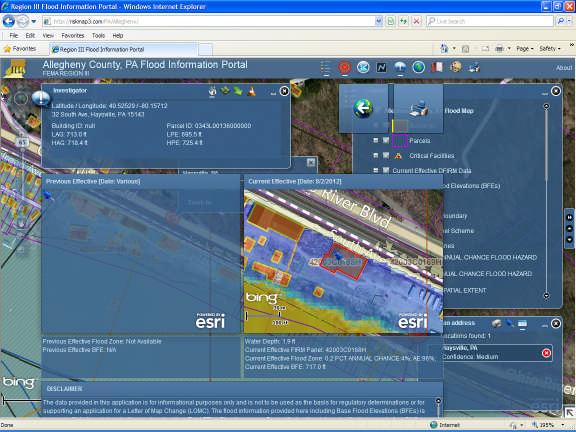
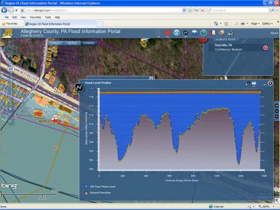
2 Using Depth Grids for Identifying Actions Depth Grids Better information on depth of flooding across the floodplain These provide enhanced data to develop a more accurate Benefit Cost Analysis (BCA) for mitigation projects, a big step towards implementation Using Flood Risk Assessment for Identifying Actions Flood Risk Assessment Identifies areas of higher flood risk by census block Quantifies potential future flood losses to existing structures Improves ability to identify areas requiring higher building code requirements Supports mitigation plan updates and disaster recovery planning through improved risk quantification 1% Chance Risk (100-yr) 7 8 Non-Regulatory Flood Risk Products and Datasets Flood Risk Map Flood Risk Datasets Depth Grids Flood Risk Assessment Flood Risk Map Flood Risk Report Flood Risk Products Flood Risk Map Flood Risk Report Flood Risk Database Flood Risk Database Access portals DVD Flood Risk Datasets Flood Risk Map & Report: Flood Risk Database: Flood Risk Report

3


4 Why We re Doing This: Hazard Mitigation Hazard Mitigation is defined as any Strategies To Reduce Your Flood Risk sustained action taken to reduce or eliminate long-term risk to life and property from hazards FEMA encourages local governments to develop Hazard Mitigation Plans To increase public and political support and a commitment for mitigation To be eligible for Hazard Mitigation Assistance grants Use new Risk MAP information to update your Hazard Mitigation Plan


5 Hazard Mitigation Builds Sustainable, Resilient Communities Strategies to Address Your Specific Areas of Concern RESILIENT tending to recover from or adjust easily to misfortune or change SUSTAIN from Latin sustinēre to hold up Synonyms: nourish, nurture A Community that plans for and mitigates against natural disasters is Resilient and more Sustainable: Economically businesses reopen more quickly Socially daily lives not as disrupted and stressed Environmentally - better functioning ecosystems with restored biodiversity Goals From Current Allegheny Co HMP Strategies From Current Allegheny County HMP Best Practices Promote hazard mitigation as a public value in recognition of its importance to the health, safety, and welfare of the population Provide community outreach and education about flooding/develop a class to educate property owners about the NFIP York Township, York County held a workshop in September to educate area local officials about Flood Risk and Insurance using the Flood Manager Program Weebles Wobble but they don t fall down 25 Ways to take Action Floodplain Management Ordinances Higher building standards Community Rating System (CRS) Reduces flood insurance premiums 26 What Action Will You Take? What are some areas of mitigation interest in your community? Can you think of any potential mitigation projects? Provide feedback to FEMA representatives during the working session Technical assistance Federal agencies and professional associations Grants for Mitigation Projects FEMA: HMGP Other Federal Agency grants: HUD/CDBG 27 Spotlight on a Local Best Practice 29 Land Use Ordinances Local Building Codes Management Best Practices Mitigation Projects Community Identified Mitigation Programs 28 Spotlight on a Regional Best Practice 30 5

 Risk MAP makes it easier to Leads to action Increases overall")


6 Spotlight on a Recent Best Practice Communication Roles and Responsibilities 31 Communicate Your Risk Flood risk awareness: 32 Communicate Your Risk (cont.) Risk MAP makes it easier to Leads to action Increases overall community resilience Builds support for implementing the mitigation plan share flood risk information with your constituents: Community outreach plan template Your constituents*: Expect to hear about flood risk from local officials, insurance agents, and real estate agents Prefer to hear about it in the local news and through mailings Draft letters to citizens Draft media materials Guidance on how to use the Risk MAP products to communicate risk User friendly Flood Risk Report * From 2010 FEMA Risk MAP Flood Risk Awareness Survey Get More from Your Data Community Development Allegheny County, PA Know Your line Initiative -High Local Hazard Mitigation Plan goal to utilize GIS for first responders Water Marks Residential/commercial density in the floodplain Location/inundation area of Build a bridge between historic events local data and maps, the Local Hazard Mitigation Plan and the Risk MAP products Total properties with insurance policies and as a percentage of the population Areas of increasing population growth Areas requiring protection
7 Emergency Management Utilizing Local Data Allegheny Co Hazard Mitigation Plan Accessibility to at risk areas, from critical facilities Industrial/Manufacturing plants in the floodplain Vulnerable populations Characteristics which make communities more/less vulnerable to flood risk Integrate Local Data and New Risk MAP Datasets Resources Next Steps: Driving Action Allegheny County, PA Flood Reference the new Allegheny County Mitigation Plan Information Portal: Substantial Damage Estimator: rd.do?id=4166 Use your new mapping tools Know Your Line Initiative - High Water Marks: To learn more about the Know Your Line Initiative, please contact Vincent Brown of FEMA at vincent.brown@fema.dhs.gov Integrate local data to enhance flood risk awareness Personally Identifiable Information (PII), will require a privacy notice. These data can t be distributed to the public if they identify individual properties

8 Breakout Groups Review the datasets and discuss how it can be used Focus on how the flood risk products and mitigation strategies can enhance plans Review incentives and discuss coordination and communication
Flood Risk in the Schuylkill Watershed. Planning for Resilient Communities
 Flood Risk in the Schuylkill Watershed Planning for Resilient Communities Welcome to Our Poster Session! We are here to talk about: Flood Risk in the Schuylkill River Watershed Taking Action to Reduce
Bucks County, PA Flood Risk Review Meeting. November 2014
 Bucks County, PA Flood Risk Review Meeting November 2014 Agenda for Today Risk MAP Program overview Overview of non-regulatory Flood Risk Products and datasets Discuss mitigation action Technical overview
Flood Risk Review (FRR) Meeting. Cumberland County, Pennsylvania Carlisle, Pennsylvania December 5, 2016
 Meeting. Cumberland County, Pennsylvania Carlisle, Pennsylvania December 5, 2016") Flood Risk Review (FRR) Meeting Cumberland County, Pennsylvania Carlisle, Pennsylvania December 5, 2016 Why are we here today? The Flood Insurance Study (FIS) report and Flood Insurance Rate Maps (FIRMs)
Flood Risk Review (FRR) Meeting Cumberland County, Pennsylvania Carlisle, Pennsylvania December 5, 2016 Why are we here today? The Flood Insurance Study (FIS) report and Flood Insurance Rate Maps (FIRMs)
Use of FEMA Non regulatory Flood Risk Products in Planning
 Use of FEMA Non regulatory Flood Risk Products in Planning Georgia Association of Floodplain Managers Annual Conference March 24, 2016 What are the Non regulatory Flood Risk products? Go beyond the basic
Discovery Meeting: Middle Potomac- Catoctin Watershed. FEMA REGION III September 26, 2012 Rockville, MD and Fairfax, VA
 Discovery Meeting: Middle Potomac- Catoctin Watershed FEMA REGION III September 26, 2012 Rockville, MD and Fairfax, VA Agenda Introductions Purpose of This Meeting Discovery Process Community Rating System
Michael Taylor, PE, CFM Project Manager, AECOM August 25, 2015
 Promoting FEMA s Flood Risk Products in the Lower Levisa Watershed Michael Taylor, PE, CFM Project Manager, AECOM August 25, 2015 Agenda Study Background Flood Risk Product Overview AOMI and Mitigation
Flood Risk Resilience in Alabama: Challenges and Successes
 Flood Risk Resilience in Alabama: Challenges and Successes Leslie A. Durham, P.E. Floodplain Management Branch Chief Alabama Office of Water Resources 10 Year Partnership with FEMA Flood Map Modernization
Kentucky Risk MAP It s not Map Mod II
 Kentucky Risk MAP It s not Map Mod II Risk Mapping Assessment and Planning Carey Johnson Kentucky Division of Water carey.johnson@ky.gov What is Risk MAP? Risk Mapping, Assessment, and Planning (Risk MAP)
Findings/Debrief Meeting September 9, CDOT R4 Headquarters Big Thompson Conference Room W 10 th St. Greeley, CO 80634
 Findings/Debrief Meeting September 9, 2016 CDOT R4 Headquarters Big Thompson Conference Room 10601 W 10 th St. Greeley, CO 80634 Discovery Review & Outcome May 25 Discovery Meeting Summary Summarize Data
New Tools for Mitigation & Outreach. Louie Greenwell Stantec
 New Tools for Mitigation & Outreach Louie Greenwell Stantec Our Discussion Today Background What is Risk MAP? FEMA Products Overview of RiskMAP Data Sets Changes Since Last FIRM Depth and Analysis Grids
Location: Tampa, Florida March 6, 2013
 Discovery Meeting: West Florida Coastal Study Location: Tampa, Florida March 6, 2013 Agenda Introductions Why we are here Outline Risk MAP products and datasets Discovery Overview: Project scoping and
Georgia Flood M.A.P. Program Risk MAP Plenary Session GAFM 2011
 Georgia Flood M.A.P. Program Risk MAP Plenary Session GAFM 2011 Collis Brown, Georgia DNR March 24, 2011 GA Flood Map Modernization Responsible for end-to-end production Developed aggressive outreach program
WELCOME!! Please sign in on one of the attendance rosters
 Georgia Emergency Management Agency GEMAOffice of Homeland Security Jackson County Hazard Mitigation Plan Update Kickoff Meeting WELCOME!! Please sign in on one of the attendance rosters Brian Laughlin
Flood Hazard Risk Mapping:
 Mitigation Division Flood Hazard Risk Mapping: Past, Present and Future Oklahoma Floodplain Management Association Ron Wanhanen, PE FEMA Region 6 Risk Analysis Branch Overview The Past The Present Risk
Plan Maintenance Procedures
 PLAN MAINTENANCE PLAN MAINTENANCE PROCEDURES... 1 MONITORING AND EVALUATION... 2 PLAN MONITORING... 2 PLAN EVALUATION... 2 UPDATING... 2 PLAN AMENDMENTS... 2 FIVE (5) YEAR REVIEW... 3 INCORPORATION...
David A. Stroud, CFM AMEC Earth & Environmental Raleigh, NC
 David A. Stroud, CFM AMEC Earth & Environmental Raleigh, NC Objectives Risk MAP background North Carolina s Risk MAP role Role of communication in Risk MAP Effective risk communication two examples Multi-hazard
FLOODPLAIN MANAGEMENT PLAN 2015 ANNUAL PROGRESS REPORT
 FLOODPLAIN MANAGEMENT PLAN 2015 ANNUAL PROGRESS REPORT Hinds County (Unincorporated) NFIP Community Number 280070 The 2015 Floodplain Management Plan Annual Progress Report on the progress made in implementing
National Capitol Region HAZUS User Group Call
 Listen to the recording here to follow along with the presentation: http://www.freeconferencecalling.com/recordings/recording.aspx?fileid=l AF3494_04252013070630062_1154707&bridge=697620&email=&account
Non Regulatory Risk MAP Products Flood Depth and Probability Grids
 Non Regulatory Risk MAP Products Flood Depth and Probability Grids Virginia Floodplain Management Association 2015 Floodplain Management Workshop October 29th, 2015 Nabil Ghalayini, P.E., PMP, D.WRE, CFM
Cumberland County, NJ. Risk MAP Project Status Update April 22, 2013
 Cumberland County, NJ Risk MAP Project Status Update April 22, 2013 Agenda Project Team Milestones Risk MAP Overview Study Scope overview Regulatory products Non-regulatory products Proposed Schedule Risk
ASFPM Partnerships for Statewide Mitigation Actions. Alicia Williams GIS and HMP Section Manager, Amec Foster Wheeler June 2016
 ASFPM Partnerships for Statewide Mitigation Actions Alicia Williams GIS and HMP Section Manager, Amec Foster Wheeler June 2016 Summary The Concept Leveraging Existing Data and Partnerships to reduce risk
State of Vermont FLOODPLAIN MANAGEMENT WORK PLAN
 State of Vermont FLOODPLAIN MANAGEMENT WORK PLAN Prepared by: Vermont Agency of Natural Resources Department of Environmental Conservation Water Quality Division July 2004 TABLE OF CONTENTS INTRODUCTION...
PLAN MAINTENANCE. Plan Maintenance Procedures. Monitoring and Evaluation
 PLAN MAINTENANCE Plan Maintenance Procedures... 1 Monitoring and Evaluation... 1 Plan Monitoring... 2 Plan Evaluation... 2 Updating... 2 Plan Amendments... 2 Five (5) Year Review... 2 Incorporation...
Preliminary Work Map Release
 Coastal Mapping in New Jersey Preliminary Work Map Release Monmouth County, New Jersey June 14, 2013 Agenda Introduction and Purpose of Briefing Hurricane Sandy Advisory Base Flood Elevations Transitioning
FEMA FLOOD MAPS Public Works Department Stormwater Management Division March 6, 2018
 FEMA FLOOD MAPS Public Works Department Stormwater Management Division March 6, 2018 Presentation Overview FEMA National Flood Insurance Program (NFIP) FEMA Community Rating System (CRS) Flood Insurance
Hazard Mitigation Grants. Technical Assistance Session Middlesex County, NJ December 7, 2011
 Hazard Mitigation Grants Technical Assistance Session Middlesex County, NJ December 7, 2011 Outline Purpose of Hazard Mitigation Hazard Mitigation Projects Hazard Mitigation Assistance Grant Programs Using
Disaster Insurance: Are States and Insurance Companies Prepared?
 Disaster Insurance: Are States and Insurance Companies Prepared? National Conference of State Legislatures 2015 Legislative Summit Roy Wright Deputy Associate Administrator for Insurance and Mitigation
Southwest Florida Discovery Kick-Off Meeting. February 4, 2014
 Southwest Florida Discovery Kick-Off Meeting February 4, 2014 Agenda Introductions Outline Risk MAP products and datasets Project scoping and schedule Data gathered Next steps Gather stakeholder input/feedback
The Community Rating System in Coastal New England: Regional Approaches and Lessons Learned
 Session 4: Flood Insurance and the Community Rating System The Community Rating System in Coastal New England: Regional Approaches and Lessons Learned Abbie Sherwin - Maine Coastal Program Julie LaBranche
Delaware Bay / River Coastal Flood Risk Study. FEMA REGION II and III September 19, 2012
 Delaware Bay / River Coastal Flood Risk Study FEMA REGION II and III September 19, 2012 Agenda Risk MAP Program Overview Risk MAP Non-Regulatory Products & Datasets Region II New Jersey Coastal Flood Study
LOCAL MITIGATION PLAN REVIEW TOOL
 LOCAL MITIGATION PLAN REVIEW TOOL The Local Mitigation Plan Review Tool demonstrates how the Local Mitigation Plan meets the regulation in 44 CFR 201.6 and offers States and FEMA Mitigation Planners an
CITY OF PLANTATION ENGINEERING DEPARTMENT INTEROFFICE MEMORANDUM NO
 CITY OF PLANTATION ENGINEERING DEPARTMENT INTEROFFICE MEMORANDUM NO. 2013-003 DATE: October 22, 2012 TO: Mayor and Members of City Council FROM: Brett W. Butler, PE, CFM City Engineer SUBJECT: CRS Program
Sources of FEMA Funding
 ASFPM Nonstructural/Floodproofing Workshops Sources of FEMA Funding ASFPM Nonstructural/Floodproofing Committee Gene Barr, CFM Principal Project Manager Nonstructural Specialist Sources of FEMA Funding
Now You re Cooking! Recipes for Resilience. Jerri Daniels, Dewberry Diane Howe, FEMA Region 6
 Now You re Cooking! Recipes for Resilience Jerri Daniels, Dewberry jdaniels@dewberry.com Diane Howe, FEMA Region 6 diane.howe@fema.dhs.gov I ve lived here all my life 2 Who loves to cook? 3 Ingredients
New Jersey Department of Environmental Protection. Five-Year Floodplain Management Work Plan
 New Jersey Department of Environmental Protection Five-Year Floodplain Management Work Plan September 30, 2004 I. State Authority New Jersey Department of Environmental Protection Five-Year Floodplain
A Flood Mitigation Plan for the Non-Tidal N.J. Section of the Delaware River Basin. Mercer County Kick-off Meeting December 6, 2006
 A Flood Mitigation Plan for the Non-Tidal N.J. Section of the Delaware River Basin Mercer County Kick-off Meeting December 6, 2006 The Delaware River. crosses many boundaries Four states: DE, PA, NJ, NY
Federal Flood Risk Management Standards. An Update on Federal Flood Resilience Standards
 Federal Flood Risk Management Standards An Update on Federal Flood Resilience Standards Purpose of Today s Briefing Facilitate the understanding of Executive Order (E.O.)13690 and its implementation Discuss
Outreach Georgia Flood M.A.P. Program. GAFM Technical Conference Flood Risk Outreach and Policy Session
 Outreach Georgia Flood M.A.P. Program GAFM Technical Conference Flood Risk Outreach and Policy Session 7 th Annual Technical Conference, Lanier Islands March 29, 2012 Risk Communication Key Learnings People
G318 Local Mitigation Planning Workshop. Module 2: Risk Assessment. Visual 2.0
 G318 Local Mitigation Planning Workshop Module 2: Risk Assessment Visual 2.0 Unit 1 Risk Assessment Visual 2.1 Risk Assessment Process that collects information and assigns values to risks to: Identify
Flood Risk Products. New Techniques for Identifying and Communicating Flood Risk
 Flood Risk Products New Techniques for Identifying and Communicating Flood Risk Mark Zito, GISP, CFM GIS Specialist Amol Daxikar, GISP, CFM Project Manager March 28, 2012 1% Flood with 3 Feet Sea Level
HAZARD MITIGATION PLAN POINT OF CONTACT. MUNICIPAL PROFILE
 HAZARD MITIGATION PLAN POINT OF CONTACT troseberry@easton-pa.gov cmanges@easton-pa.gov MUNICIPAL PROFILE MUNICIPAL PARTICIPATION Compliance with the National Flood Insurance Program (NFIP) Identify source
T-318. Hazard Mitigation Section TDEM Recovery, Mitigation, and Standards
 T-318 Local Hazard Mitigation Plan Requirements Hazard Mitigation Section TDEM Recovery, Mitigation, and Standards Raymond Mejia, Lead Hazard Mitigation Planner Samantha Aburto, Hazard Mitigation Planner
SECTION 6: MITIGATION STRATEGIES
 SECTION 6: MITIGATION STRATEGIES This section presents mitigation actions for Somerset County to reduce potential exposure and losses identified as concerns in the Risk Assessment portion of this plan.
HAZARD MITIGATION PLAN POINT OF CONTACT. MUNICIPAL PROFILE
 HAZARD MITIGATION PLAN POINT OF CONTACT cgarges@hanleco.org hanleco33@aol.com/jmouer@hanleco.org MUNICIPAL PROFILE MUNICIPAL PARTICIPATION Compliance with the National Flood Insurance Program (NFIP) Identify
CITY OF VESTAVIA HILLS
 CITY OF VESTAVIA HILLS FLOODPLAIN MANAGEMENT PLAN KICK-OFF MEETING MARCH 10, 2015 FLOODPLAIN MANAGEMENT PLANNING COMMITTEE Representative of the following categories Preventive Maintenance (e.g., codes)
Georgia Flood M.A.P. Program
 Georgia Flood M.A.P. Program Georgia Flood M.A.P. Program The Upper Chattahoochee River Basin Risk MAP Project Transitioning State Program to align with FEMA s Risk MAP Program Increase focus on risk assessment
Chemung HUC-8 Watershed Project. February 1, 2011
 Chemung HUC-8 Watershed Project Kickoff Bi Fl t NY Big Flats, NY February 1, 2011 Introductions FEMA Region II Alan Springett, Senior Engineer, FEMA Risk Analysis Risk Assessment Lead Robert Schaefer,
10/5/2015. What Makes a Sound Floodplain Management Program? What are the Flood Problems in your Community?
 The Community Rating System (CRS) and Hazard Mitigation Planning Preparing Your Community Through Common Program Goals September 3, 2015 What Makes a Sound Floodplain Management Program? Know your community
HAZARD MITIGATION PLAN POINT OF CONTACT MUNICIPAL PROFILE
 HAZARD MITIGATION PLAN POINT OF CONTACT hankvb@entermail.net khorvath@kceinc.com MUNICIPAL PROFILE MUNICIPAL PARTICIPATION Compliance with the National Flood Insurance Program (NFIP) Topic 1. Staff Resources
in coordination with Peoria County, Planning and Zoning Department
 Prepared by Amec Foster Wheeler Environment & Infrastructure Hazard Mitigation and Emergency Management Program in coordination with Peoria County, Planning and Zoning Department The purpose of hazard
Federal Flood Insurance Changes (National Flood Insurance Program NFIP)
") Federal Flood Insurance Changes (National Flood Insurance Program NFIP) Biggert-Waters (BW-12) Flood Insurance Reform Act 2012 HR 4348 Signed by the President on July 6, 2012 Public Works, Engineering
Federal Flood Insurance Changes (National Flood Insurance Program NFIP) Biggert-Waters (BW-12) Flood Insurance Reform Act 2012 HR 4348 Signed by the President on July 6, 2012 Public Works, Engineering
Section 2. Introduction and Purpose of the LMS
 Section 2. Introduction and Purpose of the LMS 2.1 Introduction The Disaster Mitigation Act of 2000 (DMA 2000), signed into law by the President of the United States on October 30, 2000 (P.L. 106-390),
HAZARD MITIGATION PLAN POINT OF CONTACT MUNICIPAL PROFILE
 HAZARD MITIGATION PLAN POINT OF CONTACT northcatasauquaema@yahoo.com scheirerg@gmail.com MUNICIPAL PROFILE MUNICIPAL PARTICIPATION Compliance with the National Flood Insurance Program (NFIP) Identify source
Are Risk MAP Products Really on Our Mind?
 Are Risk MAP Products Really on Our Mind? ASFPM 2015 Atlanta, GA Presented By: Jason Wilson, PE, CFM William Fain, EIT, CFM Amec Foster Wheeler Presentation Overview 1. What is Risk MAP/What are Risk Map
ECONOMIC EVALUATION OF FLOODPLAIN MANAGEMENT AND FLOOD MITIGATION
 ECONOMIC EVALUATION OF FLOODPLAIN MANAGEMENT AND FLOOD MITIGATION CITY OF BIRMINGHAM, ALABAMA EDWIN REVELL, CFM FLOOD PLAIN ADMINISTRATOR DENISE PRUITT, CFM PROJECT PLANNER PRESENTATION OUTLINE 1. BACKGROUND/LOCATION
HAZARD MITIGATION PLAN POINT OF CONTACT MUNICIPAL PROFILE
 HAZARD MITIGATION PLAN POINT OF CONTACT louise@windgap-pa.gov jeffreyyob@gmail.com MUNICIPAL PROFILE MUNICIPAL PARTICIPATION Compliance with the National Flood Insurance Program (NFIP) Identify source
Community Resilience & NFIP s Community Rating system
 Community Resilience & NFIP s Community Rating system Ajita Atreya Wharton Risk Management and Decision Processes Center University of Pennsylvania National Association of Counties (NACo) Session on Risk
Cameron County, TX. Consultation Coordination Officer (CCO) Meeting. Please sign in (sheet at front of the room) Meeting will begin at 9:00
 Meeting. Please sign in (sheet at front of the room) Meeting will begin at 9:00") Cameron County, TX Consultation Coordination Officer (CCO) Meeting Please sign in (sheet at front of the room) Meeting will begin at 9:00 July 29, 2015 Lisa Jennings FEMA Region 6 Roles & Responsibilities
Cameron County, TX Consultation Coordination Officer (CCO) Meeting Please sign in (sheet at front of the room) Meeting will begin at 9:00 July 29, 2015 Lisa Jennings FEMA Region 6 Roles & Responsibilities
HAZARD MITIGATION PLAN POINT OF CONTACT MUNICIPAL PROFILE
 HAZARD MITIGATION PLAN POINT OF CONTACT brian@weisenbergtownship.org fbartholomew@weisenbergfire.com MUNICIPAL PROFILE MUNICIPAL PARTICIPATION Compliance with the National Flood Insurance Program (NFIP)
Coordinating CRS Success on a County Scale. Presented at the 41st Annual ASFPM Conference Managing Flood Risk in the Heartland
 Coordinating CRS Success on a County Scale Presented at the 41st Annual ASFPM Conference Managing Flood Risk in the Heartland May 3, 2017 Today's Speaker Cynthia Bianco, CFM, AICP/PP Community Resiliency
LOCAL MITIGATION PLAN REVIEW TOOL
 LOCAL MITIGATION PLAN REVIEW TOOL The Local Mitigation Plan Review Tool demonstrates how the Local Mitigation Plan meets the regulation in 44 CFR 201.6 and offers States and FEMA Mitigation Planners an
What are the savings? An Assessment of the National Flood Insurance Program s (NFIP) Community Rating System (CRS)
 Community Rating System (CRS)") What are the savings? An Assessment of the National Flood Insurance Program s (NFIP) Community Rating System (CRS) Ajita Atreya Postdoctoral Research Fellow Wharton Risk Management and Decision Processes
What are the savings? An Assessment of the National Flood Insurance Program s (NFIP) Community Rating System (CRS) Ajita Atreya Postdoctoral Research Fellow Wharton Risk Management and Decision Processes
1.1. PURPOSE 1.2. AUTHORITIES 1. INTRODUCTION
 1. INTRODUCTION This section briefly describes hazard mitigation planning requirements, associated grants, and this Standard State Hazard Mitigation Plan (SHMP) update s composition. HMPs define natural
Action Items for Flood Risk Management on Wildcat Creek Interagency success with floodplain management plans and flood forecast inundation maps
 Presentation to USACE 2012 Flood Risk Management and Silver Jackets Joint Workshop, Harrisburg, Pennsylvania Action Items for Flood Risk Management on Wildcat Creek Interagency success with floodplain
State of Missouri Five-Year Floodplain Management Plan
 State of Missouri Five-Year Floodplain Management Plan Prepared By: Missouri Department of Public Safety State Emergency Management Agency Floodplain/Mitigation Section September 2004 INTRODUCTION Located
LOCAL MITIGATION PLAN REVIEW TOOL
 LOCAL MITIGATION PLAN REVIEW TOOL The Local Mitigation Plan Review Tool demonstrates how the Local Mitigation Plan meets the regulation in 44 CFR 201.6 and offers States and FEMA Mitigation Planners an
SECTION 3: PLANNING PROCESS
 INTRODUCTION This section includes a description of the planning process used to develop the HMP, including how it was prepared, who was involved in the process, and how the public was involved. To ensure
TERREBONNE PARISH HAZARD MITIGATION PLAN UPDATE
 TERREBONNE PARISH HAZARD MITIGATION PLAN UPDATE HAZARD MITIGATION PLAN UPDATE COMMITTEE KICK-OFF MEETING May 22, 2014 A World of Solutions 0 PRESENTATION AGENDA I. INTRODUCTIONS AND WELCOME II. PURPOSE,
HAZARD MITIGATION PLAN POINT OF CONTACT MUNICIPAL PROFILE
 HAZARD MITIGATION PLAN POINT OF CONTACT nazareth50em1@gmail.com jessicagteel@gmail.com MUNICIPAL PROFILE MUNICIPAL PARTICIPATION 3. Describe how the public will be engaged in the current planning process
April 3, 4, & 5, 2017 Pittsburgh, Butler, Erie Western PA
 April 3, 4, & 5, 2017 Pittsburgh, Butler, Erie Western PA 2 Hazard Mitigation is: any cost-effective action taken to eliminate or reduce the long term risk to life and property from natural and technological
HAZARD MITIGATION PLAN POINT OF CONTACT MUNICIPAL PROFILE
 HAZARD MITIGATION PLAN POINT OF CONTACT jmeyers75@ptd.net joshbingham@lehighcounty.org MUNICIPAL PROFILE MUNICIPAL PARTICIPATION Compliance with the National Flood Insurance Program (NFIP) Topic 1. Staff
Flooding and the Public: Experiences from SC flooding events in 2015 and 2016
 Flooding and the Public: Experiences from SC flooding events in 2015 and 2016 Maria Cox Lamm, CFM State Coordinator SCDNR Flood Mitigation Program www.dnr.sc.gov/flood Public Reaction to Flooding Would
Floodplain Management. City Council Work Session April 16, 2013
 Floodplain Management City Council Work Session April 16, 2013 1 Discussion Agenda Flood Insurance Rate Changes Community Rating System Recommendation Floodplain Ordinance Enhancements Modifications Public
Chapter 7 Appendix B: National Flood Insurance Program Summary for Kaua'i County, 2015 Update
 Chapter 7 Appendix B: National Flood Insurance Program Summary for Kaua'i County, 2015 Update Topic Considerations Description INSURANCE SUMMARY STAFF RESOURCES How many NFIP policies are in Kaua i County?
A Flood Mitigation Plan for the Non-Tidal N.J. Section of the Delaware River Basin. Sussex County Kick-off Meeting November 28, 2006
 A Flood Mitigation Plan for the Non-Tidal N.J. Section of the Delaware River Basin Sussex County Kick-off Meeting November 28, 2006 The Delaware River. crosses many boundaries Four states: DE, PA, NJ,
9.10 HEIDELBERG TOWNSHIP
 9.10 HEIDELBERG TOWNSHIP This section presents the jurisdictional annex for Heidelberg Township. A. HAZARD MITIGATION PLAN POINT OF CONTACT Name Title/ Department Address Telephone Fax Email Primary Point
Northern Kentucky University 2018 Hazard Mitigation Plan. Public Kick-Off Meeting March 20, 2018
 Northern Kentucky University 2018 Hazard Mitigation Plan Public Kick-Off Meeting March 20, 2018 Agenda Welcome Hazard Mitigation Planning 101 Hazard Identification Exercises Next Steps Jeff Baker, NKU
HAZARD MITIGATION PLAN POINT OF CONTACT MUNICIPAL PROFILE
 HAZARD MITIGATION PLAN POINT OF CONTACT assistmanager@lowermilford.net publicworks@lowermilford.org MUNICIPAL PROFILE MUNICIPAL PARTICIPATION Compliance with the National Flood Insurance Program (NFIP)
Best Practices. for Incorporating Building Science Guidance into Community Risk MAP Implementation November 2012
 Best Practices for Incorporating Building Science Guidance into Community Risk MAP Implementation November 2012 Federal Emergency Management Agency Department of Homeland Security 500 C Street, SW Washington,
National Flood Insurance Program (NFIP) Community Rating System (CRS) Together North Jersey Resilient Task Force Meeting
 Community Rating System (CRS) Together North Jersey Resilient Task Force Meeting") National Flood Insurance Program (NFIP) Community Rating System (CRS) Together North Jersey Resilient Task Force Meeting April 3, 2017 Marianne Luhrs, AICP FEMA R2 CRS Coordinator Visual Intro-1 CRS Program
National Flood Insurance Program (NFIP) Community Rating System (CRS) Together North Jersey Resilient Task Force Meeting April 3, 2017 Marianne Luhrs, AICP FEMA R2 CRS Coordinator Visual Intro-1 CRS Program
HAZARD MITIGATION PLAN POINT OF CONTACT MUNICIPAL PROFILE
 HAZARD MITIGATION PLAN POINT OF CONTACT tatamy1@rcn.com dwerkheiser@tatamypa.com MUNICIPAL PROFILE MUNICIPAL PARTICIPATION Topic Identify source of information, if different from the one listed Additional
FEMA s Flood Map Modernization Preparing for FY09 and Beyond: Integrated Flood Data Update, Risk Assessment, and Mitigation Planning
 FEMA s Flood Map Modernization Preparing for FY09 and Beyond: Integrated Flood Data Update, Risk Assessment, and Mitigation Planning DRAFT CONCEPT PAPER June 1, 2007 Integrated Flood Data Update, Risk
Matthew W. Wall Recovery and Resilience Division Acting Director Virginia Department of Emergency Management
 Matthew W. Wall Recovery and Resilience Division Acting Director Virginia Department of Emergency Management Matthew.wall@vdem.virginia.gov 1 Hazard mitigation is any sustained action taken to reduce or
HAZARD MITIGATION PLAN POINT OF CONTACT MUNICIPAL PROFILE
 HAZARD MITIGATION PLAN POINT OF CONTACT manager@boroughoffreemansburg.org chief@boroughoffreemansburg.org MUNICIPAL PROFILE MUNICIPAL PARTICIPATION Compliance with the National Flood Insurance Program
9.46 NAZARETH BOROUGH
 9.46 NAZARETH BOROUGH This section presents the jurisdictional annex for Nazareth Borough. A. HAZARD MITIGATION PLAN POINT OF CONTACT Name Title/ Department Address Telephone Fax Email Primary Point of
Name Title/ Department Address Telephone Fax
 9.36 FORKS TOWNSHIP This section presents the jurisdictional annex for Forks Township. A. HAZARD MITIGATION PLAN POINT OF CONTACT Primary Point of Contact Name Title/ Department Address Telephone Fax Email
Iberia Parish Hazard Mitigation Plan Update Plan Steering Committee Kick-off Meeting
 Iberia Parish Hazard Mitigation Plan Update Plan Steering Committee Kick-off Meeting July 9, 2014 Iberia Parish Council Chambers New Iberia, Louisiana Introductions Officials Steering Committee members
Modernization, FEMA is Recognizing the connection between damage reduction and
 EXECUTIVE SUMMARY Every year, devastating floods impact the Nation by taking lives and damaging homes, businesses, public infrastructure, and other property. This damage could be reduced significantly
Flood Smart Communities
 Flood Smart Communities Stevie Adams, Freshwater Specialist, The Nature Conservancy Funding provided by NOAA Coastal Storms Program through Ohio Sea Grant To conserve the lands and waters on which all
Flood Risk Assessment in the
 Georgia Flood M.A.P. Program Flood Risk Assessment in the Upper Chattahoochee h h River Basin GAFM Annual Conference March 28, 2012 Agenda Map Mod to Risk MAP (Georgia Flood M.A.P.) transition Flood Risk
HAZARD MITIGATION PLAN POINT OF CONTACT. MUNICIPAL PROFILE
 HAZARD MITIGATION PLAN POINT OF CONTACT washtwpemc@ptd.net MUNICIPAL PROFILE MUNICIPAL PARTICIPATION Compliance with the National Flood Insurance Program (NFIP) Topic 1. Staff Resources Is the Community
9.2 ALBURTIS BOROUGH. This section presents the jurisdictional annex for Alburtis Borough. A. HAZARD MITIGATION PLAN POINT OF CONTACT
 9.2 ALBURTIS BOROUGH This section presents the jurisdictional annex for Alburtis Borough. A. HAZARD MITIGATION PLAN POINT OF CONTACT Name Title/ Department Address Telephone Fax Email Primary Point of
Hazard Mitigation Overview
 Hazard Mitigation Overview Yahara Lakes Advisory Group April 28, 2011 1 Discussion Topics Recent flood losses and damages Hazard mitigation programs Project opportunities 2 Recent Flood Losses* Date May
HAZARD MITIGATION PLAN POINT OF CONTACT MUNICIPAL PROFILE
 HAZARD MITIGATION PLAN POINT OF CONTACT stockpolice@rcn.com stockworks@rcn.com MUNICIPAL PROFILE MUNICIPAL PARTICIPATION Compliance with the National Flood Insurance Program (NFIP) Identify source of information,
HAZARD MITIGATION PLAN POINT OF CONTACT MUNICIPAL PROFILE
 HAZARD MITIGATION PLAN POINT OF CONTACT glendonboro@rcn.com glendonboro@rcn.com MUNICIPAL PROFILE MUNICIPAL PARTICIPATION Identify source of information, if different Topic from the one listed 1. Staff
Name Title/ Department Address Telephone Fax
 9.14 LYNN TOWNSHIP This section presents the jurisdictional annex for Lynn Township. A. HAZARD MITIGATION PLAN POINT OF CONTACT Name Title Address Telephone Fax Email Primary Point of Contact Janet Henritzy
HAZARD MITIGATION PLAN POINT OF CONTACT MUNICIPAL PROFILE
 HAZARD MITIGATION PLAN POINT OF CONTACT abranco@fhboro.org pw@fhboro.org MUNICIPAL PROFILE MUNICIPAL PARTICIPATION Topic Identify source of information, if different from the one listed Additional Comments
Winter Storm Jonas Hazard Mitigation Grant Program
 Winter Storm Jonas Hazard Mitigation Grant Program Avalon, Ocean City, Sea Isle City and Stone Harbor March 25, 2017 Sea Isle City April 1, 2017 Ocean City Today's Agenda Nor Easter Jonas Hazard Mitigation
APPENDIX A: 2018 Revisions Log
 A: 2018 Revisions Log APPENDIX A: 2018 Revisions Log Florida Division of Emergency Management A: 2018 Revisions Log 2018 Maintenance Maintenance 2.1, 2.2 B 2.1, 2.2 B Risk Assessment 3.1, 3.3 Risk Assessment
This survey is expected to take approximately 20 minutes and must be completed in one session.
 State Flood Assessment Survey 1 Introduction Thank you for your willingness to participate in this online survey as part of the State Flood Assessment effort. This first step toward developing comprehensive