Flood Smart Communities
|
|
|
- Vincent Gilmore
- 5 years ago
- Views:
Transcription

1 Flood Smart Communities Stevie Adams, Freshwater Specialist, The Nature Conservancy Funding provided by NOAA Coastal Storms Program through Ohio Sea Grant


2 To conserve the lands and waters on which all life depends. We use science and partnerships to find solutions to environmental challenges.

3 Functioning Floodplains

4 Functioning Floodplains Conversion of natural floodplains can lead to: At risk development Reduced or eliminated flood storage of the floodplain Altered hydrology downstream

5 The Flood Smart Approach Watershed approach to floodplain management Community-specific assessments Systematic decision making Wide range of expertise with local needs and knowledge
6 The Flood Smart Approach 1. Identify the Problem 2. Conduct Community Study Describe Flooding What kind of flooding What are the causes and impacts Community Resilience Building Workshop - Key stakeholders identify top flood hazards, current challenges, strengths, and priority actions 1. Land use and planning environment 2. Natural infrastructure 3. Findings from CRB Workshop 4. Vulnerability assessment to flooding 5. Road/stream crossing assessment 6. Barriers and challenges to flood risk management 7. Local and State policy gap analysis
7 The Flood Smart Approach 3a. Define the Purpose and Objectives Statement of purpose What do munis want to get out of project? What are their constraints? What is in their power to influence? 3b. Define the Purpose and Objectives Objectives What should the recommendations achieve?
8 The Flood Smart Approach 4. Develop Recommendations Recommendations What actions can be taken to make communities more resilient to flooding (that will achieve objectives)? 5. Assess Effectiveness Measure effectiveness of implementing recommendations and effectiveness of reducing vulnerability
9 The Recommendations and Implementing the Plan
10 Monroe Recommendations 1. Convene intermunicipal work group Meets regularly Is responsible for implementing the Flood Smart Action Plan Provides a forum for communication and information sharing Builds and maintains partnership and collaboration between Greece, Parma, and Hilton and upstream municipalities 2. Develop training requirements or program for municipal boards Power to protect development from the impacts of flooding Empower member with information 3. Adopt intermunicipal floodplain protection overlay district (POD) Acknowledges the upstream-downstream connection of communities Requires additional and intermunicipal review of site plans for building permits Includes floodplains not mapped by FEMA 4. Strengthen local flood damage prevention laws Commit to higher standards that will better protect people and assets Can also secure more Community Rating System points which benefits community resilience and flood insurance policy holders 5. Convene agricultural interests Strengthen relationships with agricultural interests to protect this important component of the local economy Reduce flooding contributions from these lands.
11 Monroe Recommendations 6. Educate at-risk property owners Help residents be more prepared so that they can respond to and recover from flooding more effectively 7. Prioritize and protect natural infrastructure Helps reduce impacts of flood events by storing water and releasing it more slowly to the stream network and groundwater Protect floodplains and wetlands that lie upstream of population centers so they continue to provide flood attenuation services 8. Share data with municipalities and the public Compiling GIS data and other data produced during this project Make info available to the public so it can used in decision making Improve communication by providing the same info to everyone 9. Utilize the Community Rating System A voluntary incentive program to exceed minimum NFIP requirements Improve public safety, reduce property loss, protect open space and natural resources, and recover better postdisaster A discount of up to 45% off flood insurance premiums
12 Implementing the Plan 1. Flood work group Subcommittee of Stormwater Coalition of Monroe County 2. Training opportunities Local Government Workshops and Silver Jackets interagency education opportunity and site visit 3. Floodplain Protection Overlay District G/FLRPcC secured grant funds and is in midst of project to develop model local law 4. Local Flood Damage Prevention Law Updating Comprehensive Plan 5. Educate property owners Greece is working with H 2 O Hero program to include flooding messages. 6. Prioritize Natural Infrastructure Completed floodplain function assessment, map of priority areas for flood mitigation/abatement 7. Share data Submitted grant proposals for statewide online mapper 8. Utilize CRS Completed CRS Quick Check as a next step to application
13 Questions? Stevie Adams, For more information: Funding provided by NOAA Coastal Storms Program through Ohio Sea Grant
14 The Community Study
15 Flooding Vulnerability Assessment Physical Soil, hydrological and topographic conditions Social Socioeconomic factors that indicate a higher risk of residents being impacted by flooding, weighted by population density Structural The number of structures located in floodplains and flood prone areas and certain characteristics Economic The value of structures, the contents within and the productivity of local workers and businesses

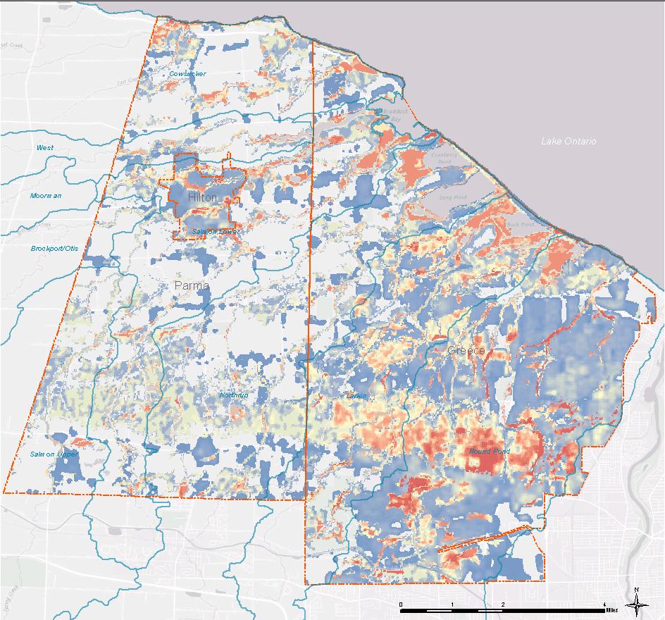
16 Composite Vulnerability to Flooding
Community Incentives for Nature-Based Flood Solutions
 Community Incentives for Nature-Based Flood Solutions A GUIDE TO FEMA S COMMUNITY RATING SYSTEM FOR CONSERVATION PRACTITIONERS The Federal Emergency Management Agency (FEMA) uses a Community Rating System
Flood Smart Action Plan. Town of Greece, Town of Parma and Village of Hilton
 Flood Smart Action Plan Town of Greece, Town of Parma and Village of Hilton Flood Smart Action Plan Town of Greece, Town of Parma, and Village of Hilton September 2016 This report was prepared by: Stevie
The Community Rating System in Coastal New England: Regional Approaches and Lessons Learned
 Session 4: Flood Insurance and the Community Rating System The Community Rating System in Coastal New England: Regional Approaches and Lessons Learned Abbie Sherwin - Maine Coastal Program Julie LaBranche
Action Items for Flood Risk Management on Wildcat Creek Interagency success with floodplain management plans and flood forecast inundation maps
 Presentation to USACE 2012 Flood Risk Management and Silver Jackets Joint Workshop, Harrisburg, Pennsylvania Action Items for Flood Risk Management on Wildcat Creek Interagency success with floodplain
Georgia Silver Jackets Team
 Georgia Silver Jackets Team 9 th Annual GAFM Technical Conference Jeff Morris GA SJ Collaborator Savannah District, USACE US Army Corps of Engineers SMART GOVERNMENT Integrate and synchronize flood risk
State of South Carolina Five-Year Floodplain Management Work Plan
 Purpose The purpose of the Community Assistance Program State Support Services Element (CAP-SSSE) is to provide, through a State grant mechanism, a means to ensure that communities participating in the
New Jersey Department of Environmental Protection. Five-Year Floodplain Management Work Plan
 New Jersey Department of Environmental Protection Five-Year Floodplain Management Work Plan September 30, 2004 I. State Authority New Jersey Department of Environmental Protection Five-Year Floodplain
Findings/Debrief Meeting September 9, CDOT R4 Headquarters Big Thompson Conference Room W 10 th St. Greeley, CO 80634
 Findings/Debrief Meeting September 9, 2016 CDOT R4 Headquarters Big Thompson Conference Room 10601 W 10 th St. Greeley, CO 80634 Discovery Review & Outcome May 25 Discovery Meeting Summary Summarize Data
Use of FEMA Non regulatory Flood Risk Products in Planning
 Use of FEMA Non regulatory Flood Risk Products in Planning Georgia Association of Floodplain Managers Annual Conference March 24, 2016 What are the Non regulatory Flood Risk products? Go beyond the basic
FEMA FLOOD MAPS Public Works Department Stormwater Management Division March 6, 2018
 FEMA FLOOD MAPS Public Works Department Stormwater Management Division March 6, 2018 Presentation Overview FEMA National Flood Insurance Program (NFIP) FEMA Community Rating System (CRS) Flood Insurance
National Flood Insurance Program (NFIP)
") National Flood Insurance Program (NFIP) Programmatic EIS (PEIS) Informing our Understanding of the NFIP and the Environment ASFPM June 12, 2013 Overview/Outline After this Seminar you should know: Who
National Flood Insurance Program (NFIP) Programmatic EIS (PEIS) Informing our Understanding of the NFIP and the Environment ASFPM June 12, 2013 Overview/Outline After this Seminar you should know: Who
Non Regulatory Risk MAP Products Flood Depth and Probability Grids
 Non Regulatory Risk MAP Products Flood Depth and Probability Grids Virginia Floodplain Management Association 2015 Floodplain Management Workshop October 29th, 2015 Nabil Ghalayini, P.E., PMP, D.WRE, CFM
SILVER JACKETS: TEAMING TO MITIGATE AND MANAGE STATE FLOOD HAZARD PRIORITIES
 SILVER JACKETS: TEAMING TO MITIGATE AND MANAGE STATE FLOOD 255 255 255 237 237 237 0 0 0 217 217 217 163 163 163 200 200 200 131 132 122 239 65 53 80 119 27 HAZARD PRIORITIES 110 135 120 252 174.59 112
Genesee/Finger Lakes Regional Planning Council
 MODEL INTERMUNICIPAL FLOODPLAIN OVERLAY DISTRICT LOCAL LAW Article I: Purpose and Intent 1. Flooding is the primary natural hazard in New York State, causing millions of dollars worth of damage to homes
Flood Risk Resilience in Alabama: Challenges and Successes
 Flood Risk Resilience in Alabama: Challenges and Successes Leslie A. Durham, P.E. Floodplain Management Branch Chief Alabama Office of Water Resources 10 Year Partnership with FEMA Flood Map Modernization
County of Kaua'i Multi-Hazard Mitigation and Resilience Plan, 2015 Update
 Executive Summary: County of Kaua'i Multi-Hazard Mitigation and Resilience Plan Introduction to the Mitigation and Resilience Plan In this third plan, the longer term needs for sustaining mitigation efforts
Delaware River Basin Commission s Role in Flood Loss Reduction Efforts
 Delaware River Basin Commission s Role in Flood Loss Reduction Efforts There is a strong need to reduce flood vulnerability and damages in the Delaware River Basin. This paper presents the ongoing role
The Changing NFIP, the CRS & Local Governments. Scott Pippin, J.D., M.E.P.D.
 The Changing NFIP, the CRS & Local Governments Scott Pippin, J.D., M.E.P.D. Flood Insurance Reform Biggert Waters 2012 (BW12) Homeowner Flood Insurance Affordability Act of 2014 (HFIAA) Bigger Waters 2012
This survey is expected to take approximately 20 minutes and must be completed in one session.
 State Flood Assessment Survey 1 Introduction Thank you for your willingness to participate in this online survey as part of the State Flood Assessment effort. This first step toward developing comprehensive
Kentucky Risk MAP It s not Map Mod II
 Kentucky Risk MAP It s not Map Mod II Risk Mapping Assessment and Planning Carey Johnson Kentucky Division of Water carey.johnson@ky.gov What is Risk MAP? Risk Mapping, Assessment, and Planning (Risk MAP)
This survey is expected to take approximately 20 minutes and must be completed in one session.
 Introduction Thank you for your willingness to participate in this online survey as part of the State Flood Assessment effort. This first step toward developing comprehensive flood planning for Texas does
Public Meeting 28 November Presented by: Deepa Srinivasan, Vision Planning and Consulting, LLC Dr. Michael Scott, ESRGC, Salisbury University
 Public Meeting 28 November 2016 Presented by: Deepa Srinivasan, Vision Planning and Consulting, LLC Dr. Michael Scott, ESRGC, Salisbury University To update the all-hazards mitigation plan and flood mitigation
Volusia County Floodplain Management Plan 2012
 Volusia County Floodplain Management Plan 2012 Introduction The National Flood Insurance Program (NFIP) provides federally supported flood insurance in communities that regulate development in floodplains.
10/5/2015. What Makes a Sound Floodplain Management Program? What are the Flood Problems in your Community?
 The Community Rating System (CRS) and Hazard Mitigation Planning Preparing Your Community Through Common Program Goals September 3, 2015 What Makes a Sound Floodplain Management Program? Know your community
HOW PLANNING FOR SEA LEVEL RISE CREATES FLOOD INSURANCE REDUCTIONS: THE GEORGIA CONTEXT. Hunter Jones 1 I. INTRODUCTION
 HOW PLANNING FOR SEA LEVEL RISE CREATES FLOOD INSURANCE REDUCTIONS: THE GEORGIA CONTEXT Hunter Jones 1 I. INTRODUCTION Flood insurance rates are rising for homeowners. One way local governments can create
G318 Local Mitigation Planning Workshop. Module 2: Risk Assessment. Visual 2.0
 G318 Local Mitigation Planning Workshop Module 2: Risk Assessment Visual 2.0 Unit 1 Risk Assessment Visual 2.1 Risk Assessment Process that collects information and assigns values to risks to: Identify
Flood Plain Management Services (FPMS) Program
 Program") Flood Plain Management Services (FPMS) Program 2016 Winter Stakeholder Partnering Forum March 2016 Mario Beddingfield, P.E., CFM Hydraulic Engineer/FPMS Program Manager H&H/Water Control Branch U.S. Army
Flood Plain Management Services (FPMS) Program 2016 Winter Stakeholder Partnering Forum March 2016 Mario Beddingfield, P.E., CFM Hydraulic Engineer/FPMS Program Manager H&H/Water Control Branch U.S. Army
FLOODPLAIN MANAGEMENT PLAN 2015 ANNUAL PROGRESS REPORT
 FLOODPLAIN MANAGEMENT PLAN 2015 ANNUAL PROGRESS REPORT Hinds County (Unincorporated) NFIP Community Number 280070 The 2015 Floodplain Management Plan Annual Progress Report on the progress made in implementing
California s Flood Future Recommendations for Managing the State s Flood Risk. BAFPAA Briefing February 21, 2013
 California s Flood Future Recommendations for Managing the State s Flood Risk BAFPAA Briefing February 21, 2013 Overview Purpose Understanding the Situation The Problem Research Findings Recommendations
Role of Disaster Insurance in Improving Resilience: An Expert Meeting The Resilient America Roundtable
 Role of Disaster Insurance in Improving Resilience: An Expert Meeting The Resilient America Roundtable National Academy of Science Washington, DC July 9, 2015 Roseville Demographics Primary population
LOCAL MITIGATION PLAN REVIEW TOOL
 LOCAL MITIGATION PLAN REVIEW TOOL The Local Mitigation Plan Review Tool demonstrates how the Local Mitigation Plan meets the regulation in 44 CFR 201.6 and offers States and FEMA Mitigation Planners an
Crediting Adaptation Strategies through the National Flood Insurance Program s Community Rating System Coordinator s Manual
 Crediting Adaptation Strategies through the National Flood Insurance Program s Community Rating System Coordinator s Manual W. Thomas Hawkins, Adjunct Faculty, University of Florida, Levin College of Law
HAZARD MITIGATION PLAN POINT OF CONTACT MUNICIPAL PROFILE
 HAZARD MITIGATION PLAN POINT OF CONTACT northcatasauquaema@yahoo.com scheirerg@gmail.com MUNICIPAL PROFILE MUNICIPAL PARTICIPATION Compliance with the National Flood Insurance Program (NFIP) Identify source
LOCAL MITIGATION PLAN REVIEW TOOL
 LOCAL MITIGATION PLAN REVIEW TOOL The Local Mitigation Plan Review Tool demonstrates how the Local Mitigation Plan meets the regulation in 44 CFR 201.6 and offers States and FEMA Mitigation Planners an
Federal Floodplain Mapping Guideline Series. CRHNet 2017 Symposium Halifax, Nova Scotia October 25, 2017
 Federal Floodplain Mapping Guideline Series CRHNet 2017 Symposium Halifax, Nova Scotia October 25, 2017 Overview 1. Introduction to Floodplain Maps 2. Federal Floodplain Mapping Guidelines Series 3. Stakeholder
Community Resilience & NFIP s Community Rating system
 Community Resilience & NFIP s Community Rating system Ajita Atreya Wharton Risk Management and Decision Processes Center University of Pennsylvania National Association of Counties (NACo) Session on Risk
Floodplain Management Services Baltimore District Studies
 Floodplain Management Services Baltimore District Studies FACT SHEET as of December 31, 2014 AUTHORIZATION: Floodplain Management Services (FPMS) TYPE OF PROJECT: Flood Risk Management (Technical Services)
STATE OF MARYLAND FLOODPLAIN MANAGEMENT PLAN FIVE-YEAR WORK PLAN DRAFT SEPTEMBER, 2004
 STATE OF MARYLAND FLOODPLAIN MANAGEMENT PLAN FIVE-YEAR WORK PLAN DRAFT SEPTEMBER, 2004 Prepared by: Maryland Department of the Environment Wetlands and Waterways Program Flood Mitigation Division D R A
David A. Stroud, CFM AMEC Earth & Environmental Raleigh, NC
 David A. Stroud, CFM AMEC Earth & Environmental Raleigh, NC Objectives Risk MAP background North Carolina s Risk MAP role Role of communication in Risk MAP Effective risk communication two examples Multi-hazard
Leveraging the Community Rating System for Climate Adaptation. Southeast and Caribbean Climate Community of Practice Webinar Series 23 March 2015
 Leveraging the Community Rating System for Climate Adaptation Southeast and Caribbean Climate Community of Practice Webinar Series 23 March 2015 Today s Speakers: Shana Jones, J.D., Carl Vinson Institute
FREQUENTLY ASKED QUESTION ABOUT FLOODPLAINS Michigan Department of Environmental Quality
 FREQUENTLY ASKED QUESTION ABOUT FLOODPLAINS Michigan Department of Environmental Quality WHAT IS A FLOOD? The National Flood Insurance Program defines a flood as a general and temporary condition of partial
HAZARD MITIGATION PLAN POINT OF CONTACT MUNICIPAL PROFILE
 HAZARD MITIGATION PLAN POINT OF CONTACT louise@windgap-pa.gov jeffreyyob@gmail.com MUNICIPAL PROFILE MUNICIPAL PARTICIPATION Compliance with the National Flood Insurance Program (NFIP) Identify source
Meeting the Nation s Levee Challenges
 ASDSO USACE/FEMA Levee Discussion Meeting the Nation s Levee Challenges November 2015 Presenters: Richard Varuso, USACE Michael Bishop, FEMA 1 This Session s Objective KNOWLEDGE - Provide you with insight
Flood Risk Review and Resilience Meeting: Allegheny County
 Flood Risk Review and Resilience Meeting: Allegheny County Allegheny County Conservation District Building December 5-6, 2012 Introductions Risk MAP Project Team Local partners and officials State partners
Flood Risk Review (FRR) Meeting. Cumberland County, Pennsylvania Carlisle, Pennsylvania December 5, 2016
 Meeting. Cumberland County, Pennsylvania Carlisle, Pennsylvania December 5, 2016") Flood Risk Review (FRR) Meeting Cumberland County, Pennsylvania Carlisle, Pennsylvania December 5, 2016 Why are we here today? The Flood Insurance Study (FIS) report and Flood Insurance Rate Maps (FIRMs)
Flood Risk Review (FRR) Meeting Cumberland County, Pennsylvania Carlisle, Pennsylvania December 5, 2016 Why are we here today? The Flood Insurance Study (FIS) report and Flood Insurance Rate Maps (FIRMs)
Planning Commission April 19, 2017 Erin Cooper, Floodplain Specialist Varda Blum, Floodplain Program Manger
 Public Hearing for Z-17-0001: Zoning Map Amendments to the Floodplain Overlay District & DC-17-0001: Land Use Code text amendments to the Floodplain regulations Planning Commission April 19, 2017 Erin
Thurston County, WA Flood Hazard Mitigation Plan Annual Progress Report CRS Activity 510
 Thurston County, WA Flood Hazard Mitigation Plan Annual Progress Report CRS Activity 510 Reporting Period: ctober 1, 2014 to September 30, 2015 Background: Thurston County developed a flood hazard mitigation
GAFM Showcase: Multiple Agencies Combating Georgia s Flood Risk Together: Proven Results Gained by Strong Partnerships
 National Flood Insurance Program Participation GAFM Showcase: Multiple Agencies Combating Georgia s Flood Risk Together: Proven Results Gained by Strong Partnerships Moderator: Jill Bazinet, PE, CFM GAFM
Community Rating System. National Flood Insurance Program
 National Flood Insurance Program Community Rating System A Local Official s Guide to Saving Lives Preventing Property Damage Reducing the Cost of Flood Insurance FEMA B-573 / May 2015 How the Community
Silver Jackets - Flood Risk Management Program
 COOPERATING TECHNICAL PARTNER INFORMATION EXCHANGE Silver Jackets - Flood Risk Management Program August 31, 2017 Association of State Floodplain Managers AUDIO AND WEB SETTINGS Your Participation Open
Chapter 7 Appendix B: National Flood Insurance Program Summary for Kaua'i County, 2015 Update
 Chapter 7 Appendix B: National Flood Insurance Program Summary for Kaua'i County, 2015 Update Topic Considerations Description INSURANCE SUMMARY STAFF RESOURCES How many NFIP policies are in Kaua i County?
***EXPEDITED REVIEW***
 ***EXPEDITED REVIEW*** Application for Erosion and Sediment Pollution Control Plan Adequacy Review General NPDES Plan Review This application must be completed and accompanied by the required fees, plans,
SECTION V THE LOCAL MITIGATION STRATEGY BLUEPRINT
 SECTION V THE LOCAL MITIGATION STRATEGY BLUEPRINT A. GUIDING MITIGATION PRINCIPLES The Local Mitigation Strategy (LMS) is Hillsborough County s program developed to reduce or eliminate all forms of losses
MUNICIPAL LAND USE STRATEGIES for Improving Flood Resilience
 MUNICIPAL LAND USE STRATEGIES for Improving Flood Resilience Strategy for a Flood Resistant Southern Tier Central Region (LWRP project) This presentation was prepared by Southern Tier Central Regional
Hazard Mitigation & Resiliency
 Hazard Mitigation & Resiliency Goal: Encourage resiliency and sustainable development by protecting development from natural hazards. In Maryland Heights, the Comprehensive Plan is the responsibility of
Michael Taylor, PE, CFM Project Manager, AECOM August 25, 2015
 Promoting FEMA s Flood Risk Products in the Lower Levisa Watershed Michael Taylor, PE, CFM Project Manager, AECOM August 25, 2015 Agenda Study Background Flood Risk Product Overview AOMI and Mitigation
NFIP Program Basics. KAMM Regional Training
 NFIP Program Basics KAMM Regional Training Floodplain 101 Homeowners insurance does not cover flood damage Approximately 25,000 flood insurance policies in KY According to BW12 analysis, approximately
National Institute of Building Sciences
 National Institute of Building Sciences Provider Number: G168 Improving the Flood Resistance of Buildings and Mitigation Techniques WE3B Peter Spanos, P.E., CFM, LEED AP (Gale Associates, Inc.) Stuart
HAZARD MITIGATION PLAN POINT OF CONTACT MUNICIPAL PROFILE
 HAZARD MITIGATION PLAN POINT OF CONTACT hankvb@entermail.net khorvath@kceinc.com MUNICIPAL PROFILE MUNICIPAL PARTICIPATION Compliance with the National Flood Insurance Program (NFIP) Topic 1. Staff Resources
HAZARD MITIGATION PLAN POINT OF CONTACT MUNICIPAL PROFILE
 HAZARD MITIGATION PLAN POINT OF CONTACT glendonboro@rcn.com glendonboro@rcn.com MUNICIPAL PROFILE MUNICIPAL PARTICIPATION Identify source of information, if different Topic from the one listed 1. Staff
Mapping Flood Risk in the Upper Fox River Basin:
 Mapping Flood Risk in the Upper Fox River Basin: Vulnerable Populations and Adverse Health Effects Presented by: Angelina Hanson STUDY AREA: Wisconsin's Upper Fox River Basin Total Population 139,309.
Floodplain Management Plan State of Utah
 Utah Department of Public Safety Division of Emergency Services Floodplain Management Plan State of Utah September 2004 Prepared by: Judy Watanabe Utah Division of Emergency Services State NFIP Coordinator
Best Practices. for Incorporating Building Science Guidance into Community Risk MAP Implementation November 2012
 Best Practices for Incorporating Building Science Guidance into Community Risk MAP Implementation November 2012 Federal Emergency Management Agency Department of Homeland Security 500 C Street, SW Washington,
5/25/2017. So why don t more communities participate in the Community Rating System (CRS)? Agenda. What is CRS? Community Rating System
? Agenda. What is CRS? Community Rating System") Floodplain Management Activities Flood Insurance Rates So why don t more communities participate in the Community Rating System (CRS)? Texas Floodplain Management Association 29 th Annual Spring Conference
Floodplain Management Activities Flood Insurance Rates So why don t more communities participate in the Community Rating System (CRS)? Texas Floodplain Management Association 29 th Annual Spring Conference
LOCAL MITIGATION PLAN REVIEW TOOL
 LOCAL MITIGATION PLAN REVIEW TOOL The Local Mitigation Plan Review Tool demonstrates how the Local Mitigation Plan meets the regulation in 44 CFR 201.6 and offers States and FEMA Mitigation Planners an
HAZARD MITIGATION PLAN POINT OF CONTACT MUNICIPAL PROFILE
 HAZARD MITIGATION PLAN POINT OF CONTACT brian@weisenbergtownship.org fbartholomew@weisenbergfire.com MUNICIPAL PROFILE MUNICIPAL PARTICIPATION Compliance with the National Flood Insurance Program (NFIP)
ASFPM Partnerships for Statewide Mitigation Actions. Alicia Williams GIS and HMP Section Manager, Amec Foster Wheeler June 2016
 ASFPM Partnerships for Statewide Mitigation Actions Alicia Williams GIS and HMP Section Manager, Amec Foster Wheeler June 2016 Summary The Concept Leveraging Existing Data and Partnerships to reduce risk
Suwannee River Water Management District
 Suwannee River Water Management District FEMA Flood Map Modernization Program 5-Year Business Plan FY 2004-2009 Prepared By: URS Corporation Dewberry Water Resource Associates February 14, 2004 Revised
New Tools for Mitigation & Outreach. Louie Greenwell Stantec
 New Tools for Mitigation & Outreach Louie Greenwell Stantec Our Discussion Today Background What is Risk MAP? FEMA Products Overview of RiskMAP Data Sets Changes Since Last FIRM Depth and Analysis Grids
C APABILITY A SSESSMENT
 PURPOSE The Rappahannock Rapidan region's capability assessment was conducted to determine the ability of participating localities to develop and implement a comprehensive hazard mitigation strategy and
T-318. Hazard Mitigation Section TDEM Recovery, Mitigation, and Standards
 T-318 Local Hazard Mitigation Plan Requirements Hazard Mitigation Section TDEM Recovery, Mitigation, and Standards Raymond Mejia, Lead Hazard Mitigation Planner Samantha Aburto, Hazard Mitigation Planner
CITY OF PLANTATION ENGINEERING DEPARTMENT INTEROFFICE MEMORANDUM NO
 CITY OF PLANTATION ENGINEERING DEPARTMENT INTEROFFICE MEMORANDUM NO. 2013-003 DATE: October 22, 2012 TO: Mayor and Members of City Council FROM: Brett W. Butler, PE, CFM City Engineer SUBJECT: CRS Program
HAZARD MITIGATION PLAN POINT OF CONTACT. MUNICIPAL PROFILE
 HAZARD MITIGATION PLAN POINT OF CONTACT alacko@walnutportpa.org MUNICIPAL PROFILE MUNICIPAL PARTICIPATION Compliance with the National Flood Insurance Program (NFIP) Topic 1. Staff Resources Is the Community
2018 FMA Annual Conference in Reno, NV:
 Nevada Floodplain Management News V O L U M E INSIDE THIS ISSUE: Sustainability in 1 the Face of Change Community Rating System Workshop 2 CCRFCD Master Plan Update 3 Douglas Co. Stormwater Maintenance
Monroe County Local Mitigation Strategy (LMS) 2015 Update Working Group Meeting #1
 2015 Update Working Group Meeting #1") Monroe County Local Mitigation Strategy (LMS) 2015 Update Working Group Meeting #1 Meeting Notes Date: January 22 nd, 2015 Time: 1:00 pm 4:00 pm Location: City of Marathon Councilmen Meeting Room 8900
Monroe County Local Mitigation Strategy (LMS) 2015 Update Working Group Meeting #1 Meeting Notes Date: January 22 nd, 2015 Time: 1:00 pm 4:00 pm Location: City of Marathon Councilmen Meeting Room 8900
SOUTH CENTRAL REGION MULTI-JURISDICTION HAZARD MITIGATION PLAN. Advisory Committee Meeting September 12, 2012
 SOUTH CENTRAL REGION MULTI-JURISDICTION HAZARD MITIGATION PLAN Advisory Committee Meeting September 12, 2012 AGENDA FOR TODAY Purpose of Meeting Engage All Advisory Committee Members Distribute Project
National Flood Insurance Program (NFIP) Community Rating System (CRS) Together North Jersey Resilient Task Force Meeting
 Community Rating System (CRS) Together North Jersey Resilient Task Force Meeting") National Flood Insurance Program (NFIP) Community Rating System (CRS) Together North Jersey Resilient Task Force Meeting April 3, 2017 Marianne Luhrs, AICP FEMA R2 CRS Coordinator Visual Intro-1 CRS Program
National Flood Insurance Program (NFIP) Community Rating System (CRS) Together North Jersey Resilient Task Force Meeting April 3, 2017 Marianne Luhrs, AICP FEMA R2 CRS Coordinator Visual Intro-1 CRS Program
Technical Appendix: Protecting Open Space & Ourselves: Reducing Flood Risk in the Gulf of Mexico Through Strategic Land Conservation
 Technical Appendix: Protecting Open Space & Ourselves: Reducing Flood Risk in the Gulf of Mexico Through Strategic Land Conservation To identify the most effective watersheds for land conservation, we
Justification for Floodplain Regulatory Standards in Illinois
 Justification for Floodplain Regulatory Standards in Illinois Office of Water Resources Issue Paper April, 2015 Proactive Illinois floodplain and floodway regulatory standards have prevented billions of
ASFPM RECOMMENDED TASK FORCE ACTIONS
 Association of State Floodplain Managers, Inc. 2809 Fish Hatchery Road, Suite 204, Madison, WI 53713 Phone: 608-274-0123 Fax: 608-274-0696 Website: www.floods.org Email: asfpm@floods.org Federal Interagency
Municipal Natural Assets Initiative (MNAI): Watershed-level pilot implementation in British Columbia. Call for Expressions of Interest
: Watershed-level pilot implementation in British Columbia. Call for Expressions of Interest") Municipal Natural Assets Initiative (MNAI): Watershed-level pilot implementation in British Columbia Call for Expressions of Interest Extension: Until suitable candidate found Extension date: 20 September
Municipal Natural Assets Initiative (MNAI): Watershed-level pilot implementation in British Columbia Call for Expressions of Interest Extension: Until suitable candidate found Extension date: 20 September
National Flood Risk Management Program
 National Flood Risk Management Program US Army Corps of Engineers Floodplain Managers Association Sacramento, California July 29, 2010 Judy Soutiere Institute for Water Resources A Shared Responsibility
FEMA s Flood Map Modernization Preparing for FY09 and Beyond: Integrated Flood Data Update, Risk Assessment, and Mitigation Planning
 FEMA s Flood Map Modernization Preparing for FY09 and Beyond: Integrated Flood Data Update, Risk Assessment, and Mitigation Planning DRAFT CONCEPT PAPER June 1, 2007 Integrated Flood Data Update, Risk
Interagency Nonstructural Flood Risk Management Workshop. Carey Johnson Kentucky Division of Water
 Interagency Nonstructural Flood Risk Management Workshop Carey Johnson Kentucky Division of Water Nonstructural Flood Risk Management Nonstructural floodproofing Elevation Relocation Buyout/acquisition
FLOOD MITIGATION ACTION PLAN
 LOWER FINAL SILETZ REPORT: BASIN A Feasibility Study for an FLOOD MITIGATION ACTION PLAN Ecosystem Management Industry Clearinghouse Submitted to: Lincoln County Planning Department 210 Southwest 2 nd
EMERGENCY ACTION PLAN GUIDEBOOK
 EMERGENCY ACTION PLAN GUIDEBOOK Presented by: Terry Zien and Bonnie Greenleaf US Army Corps of Engineers Background Purpose Overview of Guidebook Discussion of Key Chapters Minnesota Silver Jackets Natural
Integrating Hazard Mitigation and Comprehensive Planning Workshop
 Delaware Valley Regional Planning Commission Philadelphia, PA April 25, 2016 12:30 p.m. Integrating Hazard Mitigation and Comprehensive Planning Workshop Stephen D. Marks Municipal Manager City of Hoboken,
Adapting Maine s coastal communities to sea level rise and storm surge (2015 State of the Bay Presentation)
") University of Southern Maine USM Digital Commons Presentations Casco Bay Estuary Partnership (CBEP) 2015 Adapting Maine s coastal communities to sea level rise and storm surge (2015 State of the Bay Presentation)
University of Southern Maine USM Digital Commons Presentations Casco Bay Estuary Partnership (CBEP) 2015 Adapting Maine s coastal communities to sea level rise and storm surge (2015 State of the Bay Presentation)
Flood Risk Outreach Tools for Georgia Communities. GAFM 10 th Annual Conference Presented By: Jarrett Mattli
 Flood Risk Outreach Tools for Georgia Communities GAFM 10 th Annual Conference Presented By: Jarrett Mattli April 13, 2016 Presentation Overview Guidebooks Toolkits Templates Educational Videos Resource
Oyster River/Saratoga Beach Managing the Flood Risk: Vulnerability and Exposure Dialogue
 Oyster River/Saratoga Beach Thank-you for your interest in attending our interactive stakeholder dialogue for the Oyster River/Saratoga Beach Flood Risk Assessment on Tuesday, January 16 th, 2018. Attached
More Legal Quick Takes: SLR, Law & Flooding
 More Legal Quick Takes: SLR, Law & Flooding Click to edit Master title style Click to edit Master subtitle style Erin Deady, President, Erin L. Deady, PA & Thomas Ruppert Coastal Planning Specialist, Florida
North Atlantic Coast Comprehensive Study: Resilient Adaption to Increasing Risk
 North Atlantic Coast Comprehensive Study: Resilient Adaption to Increasing Risk U.S. Army Corps of Engineers Coastal Storm Risk Management Planning Center of Expertise Amy M. Guise, USACE 21 November 2013
Mitigation Strategies
 Mitigation Strategies Introduction Michigan State University Mitigation Goals Identification and Analysis of Mitigation Actions Recommendation and Prioritization of Mitigation Actions Potential Funding
HAZARD MITIGATION PLAN POINT OF CONTACT MUNICIPAL PROFILE
 HAZARD MITIGATION PLAN POINT OF CONTACT nazareth50em1@gmail.com jessicagteel@gmail.com MUNICIPAL PROFILE MUNICIPAL PARTICIPATION 3. Describe how the public will be engaged in the current planning process
Board of Thurston County Commissioners. Flood Planning Committee NAME ROLE/TITLE AFFILIATION Community Representatives Scott Boettcher Stakeholder
 Board of Thurston County Commissioners NAME DISTRICT John Hutchings, Vice-Chair District 1 Gary Edwards District 2 Bud Blake, Chair District 3 Flood Planning Committee NAME ROLE/TITLE AFFILIATION Community
Hillsborough County Local Mitigation Strategy and the Community Rating System
 Hillsborough County Local Mitigation Strategy and the Community Rating System Presented By Hillsborough County s Hazard Mitigation Section Eugene Henry, Manager Hazard Mitigation Contributing Team Members:
Bucks County, PA Flood Risk Review Meeting. November 2014
 Bucks County, PA Flood Risk Review Meeting November 2014 Agenda for Today Risk MAP Program overview Overview of non-regulatory Flood Risk Products and datasets Discuss mitigation action Technical overview
4 TH ANNUAL CAPE COASTAL CONFERENCE. Adaptation Planning, Environmental Economics and Community Engagement
 4 TH ANNUAL CAPE COASTAL CONFERENCE THE RESILIENT CAPE COD PROJECT Adaptation Planning, Environmental Economics and Community Engagement K r i s t y S e n a t o r i, Cape Cod Commission NOAA COASTAL RESILIENCY
State of Vermont FLOODPLAIN MANAGEMENT WORK PLAN
 State of Vermont FLOODPLAIN MANAGEMENT WORK PLAN Prepared by: Vermont Agency of Natural Resources Department of Environmental Conservation Water Quality Division July 2004 TABLE OF CONTENTS INTRODUCTION...