Federal Floodplain Mapping Guideline Series. CRHNet 2017 Symposium Halifax, Nova Scotia October 25, 2017
|
|
|
- Camilla Hopkins
- 5 years ago
- Views:
Transcription
1 Federal Floodplain Mapping Guideline Series CRHNet 2017 Symposium Halifax, Nova Scotia October 25, 2017
2 Overview 1. Introduction to Floodplain Maps 2. Federal Floodplain Mapping Guidelines Series 3. Stakeholder Engagement 4. Hazard and Risk Assessment 5. Next Steps 2

3 Introduction Natural Resources Canada is providing technical support and expertise to the National Disaster Mitigation Program administered by Public Safety Canada. National Disaster Mitigation Program $200M Risk Assessments Flood Mapping Mitigation Planning Investments 3

4 Floodplain Maps Promote information on flood hazards Enable community preparedness and disaster mitigation planning Empower citizens and property owners Inform emergency management practices General public awareness Land use planning Necessary condition to enable insurance Investments in infrastructure Used in emergency management cycle 4

5 Floodplain Maps Inundation Maps Show floodwater extents Used for emergency management and other rapid-production uses 5

6 Floodplain Maps Hazard Maps Engineering Maps showing extents of different floods Can include depths and velocities 6

7 Floodplain Maps Risk Maps Show risks of flood hazard to socioeconomic values Used to identify consequences of flooding 7

8 Floodplain Maps Awareness Maps Communicate flood information to public Can include historical information and advice 8
9 Guidelines Series The Federal Floodplain Mapping Guidelines Series documents are being published to inform consistent practices for floodplain mapping in Canada. Collaborative Interoperable Evergreen Local Accessible Adaptable Voluntary 9
10 Guidelines Series Objectives Recognize provincial/territorial roles and responsibilities for flood mitigation Provide basis for further specification by provinces & territories Inclusive and take regional considerations into account Encourage sharing and dissemination of flood hazard information Serve all floodplain mapping practitioners and stakeholders The Guidelines are not standards they are recommended common practices. 10
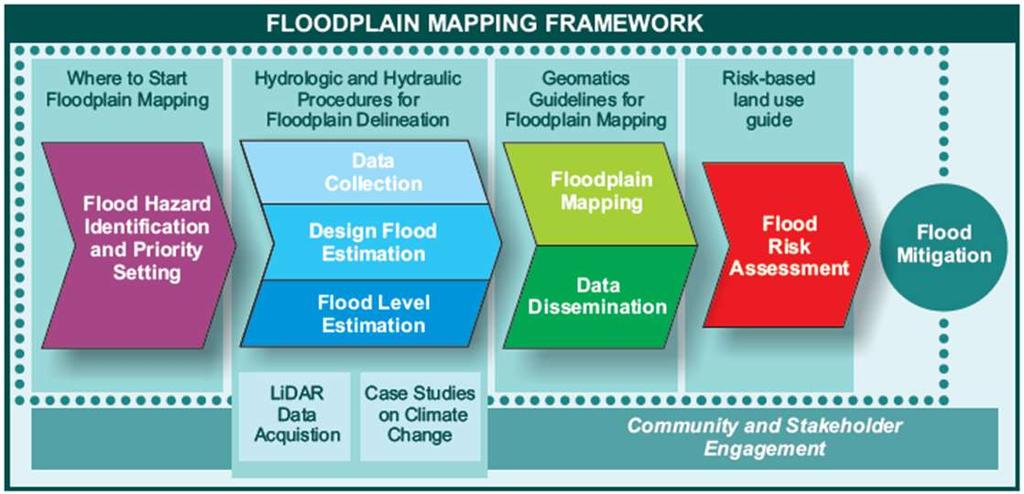
11 Guidelines Series 11
12 Guidelines Series Federal Floodplain Mapping Guidelines Series Document Status Federal Floodplain Mapping Framework Flood Hazard Identification and Priority Setting Federal Hydrologic and Hydraulic Procedures for Floodplain Delineation Federal Airborne LiDAR Data Acquisition Guideline Case Studies on Climate Change in Floodplain Mapping Federal Geomatics Guidelines for Floodplain Mapping Flood Risk Assessment Risk-Based Land Use Guide Bibliography of Best Practices and References for Flood Mitigation Published In Progress Nearly Complete Published Final Review Nearly Complete In Progress Published Published 12


13 Stakeholder Engagement Ongoing engagement since 2015 Workshops, consultation meetings, teleconferences/webinars, conferences, and contracts Technical Working Group 160 members across Canada representing all levels of government, academia, industry, consulting, and other stakeholders Ongoing consultation Federal Flood Mapping Committee Representatives from NRCAN, PS, ECCC, DND, DRDC, NRC, INAC, and INFCAN Studies and reports Research and private consultants 13
14 Hazard and Risk Assessment Flood Hazard: a potentially damaging flooding event that may cause the loss of life or injury, property damage, social and economic disruption, or environmental degradation. Flood Risk: the combination of the likelihood and the consequence of a Flood Hazard. 14


15 Hazard and Risk Assessment Risk Assessment Documents: 1. Flood Risk Assessment Guidelines Series document In progress 2. Guidelines and Database of Flood Vulnerability Functions Annex to Flood Risk Assessment document In progress 3. Risk Based Land Use Guide Published by NRCan (2015) Addresses flooding and other hazards 15

16 Hazard and Risk Assessment 16
17 Hazard and Risk Assessment National Risk Profile for Canada The objective of this initiative is to design a sustainable approach for national risk assessment: top-down risk assessment methods (national scenario-based planning; capability assessment; and critical infrastructure interdependence); bottom-up municipal level assessments (submitted under the National Disaster Mitigation Program and local hazard mapping and modelling initiatives). 17
18 Hazard and Risk Assessment The National Risk Profile aims to design and pilot a sustainable approach for National Risk Assessment: Part 1: National Risk Profile Document Part 2: Structure and Governance Model 18


19 NRP System NRP Document Flood Maps Hazard and Risk Assessment Chapter 1: Capability-based planning Chapter 2: Communitybased planning Chapter 3: Hazard/Risk Modelling Regional Profiles All-hazards Risk Assessment National Risk/Resilience Aggregation Process NDMP Risk/Resilience Common Input Templates NDMP Risk/Resilience Toolkit National Flood Mapping Guide lines National Disaster Mitigation Program 19
20 Next Steps Consultation on the Federal Floodplain Mapping Guidelines is ongoing: CRHNet 2017 March 2018 Flood Risk Assessment Workshop Contracts with consultants Consultations with Provinces / Territories Engaging Indigenous communities 20

21 Conclusion The Federal Floodplain Mapping Guidelines Series is laying the groundwork for a more resilient future by promoting common approaches to floodplain mapping across Canada. 21
22 Questions?
Canada s Evolving National Risk Profile
 Canada s Evolving National Risk Profile Matt Godsoe PS Canada Shaye Friesen DRDC CSS Presentation to CRHNet November 2016 Outline Provide background on development of a National Risk Profile (NRP) for
National Disaster Mitigation Program NDMP Overview, Ontario Projects, and Final Call for Proposals
 National Disaster Mitigation Program NDMP Overview, Ontario Projects, and Final Call for Proposals March 6, 2018 NDMP Overview The NDMP is a 5-year federal program that set out $183 million for flood mitigation
Oyster River/Saratoga Beach Managing the Flood Risk: Vulnerability and Exposure Dialogue
 Oyster River/Saratoga Beach Thank-you for your interest in attending our interactive stakeholder dialogue for the Oyster River/Saratoga Beach Flood Risk Assessment on Tuesday, January 16 th, 2018. Attached
Canada s Evolving Risk Profile. Matt Godsoe Defence Research and Development Canada
 Canada s Evolving Risk Profile Matt Godsoe Defence Research and Development Canada Number of Disasters Disaster Trends in Canada 250 Disasters in Canada 200 150 100 Non-Natural (e.g. industrial accident,
Flood Risk, Insurance and Integrated Flood Hazard Management
 Canadian Water Resources Association Association Canadienne des Ressources Hydriques Flood Risk, Insurance and Integrated Flood Hazard Management Dave Murray, National President June 8-9, 2016 Window on
The Hydro-illogical Cycle
 The Hydro-illogical Cycle and the case for Integrated Flood Hazard Management Dave Murray, P.Eng., CWRA National President Canadian Water Resources Association Association Canadienne des Ressources Hydriques
NEWS RELEASE. All levels of government support 30 British Columbia flood mitigation projects
 For Immediate Release 2018PSSG0005-000150 Feb. 2, 2018 NEWS RELEASE Ministry of Public Safety and Solicitor General Emergency Management BC Public Safety Canada All levels of government support 30 British
Item No Halifax Regional Council October 30, 2018
 P.O. Box 1749 Halifax, Nova Scotia B3J 3A5 Canada Item No. 14.2.1 Halifax Regional Council October 30, 2018 TO: Mayor Savage and Members of Halifax Regional Council Original Signed SUBMITTED BY: Councillor
Flood Hazards & Infrastructure Risk in the Lower Mainland Towards a Regional Strategy for Risk Reduction
 Flood Hazards & Infrastructure Risk in the Lower Mainland Towards a Regional Strategy for Risk Reduction Fraser Basin Council Infrastructure Sector Workshop November 5, 2018 Lower Mainland Flood Management
How will the new Federal Flood Fund be rolled out?: National Floodplain Mapping Technical Working Group A CWRA Update
 Canadian Water Resources Association Association Canadienne des Ressources Hydriques How will the new Federal Flood Fund be rolled out?: National Floodplain Mapping Technical Working Group A CWRA Update
RESILIENT INFRASTRUCTURE June 1 4, 2016
 RESILIENT INFRASTRUCTURE June 1 4, 2016 MUNICIPAL RISK ASSESSMENT TOOL (MRAT) Scott Praill Dillon Consulting Limited, Canada ABSTRACT MRAT is a made-in-canada tool that overlays municipal data sets and
Helping communities weather the storm. Shawna Peddle Adaptation Canada 2016 April 13, 2016
 Helping communities weather the storm Shawna Peddle Adaptation Canada 2016 April 13, 2016 FLOOD HAPPENS Our climate is changing Increasing precipitation, snow and ice melt Our communities are changing
2018 PREPARING FOR A CHANGING CLIMATE AND MANAGING THE RISING FLOOD RISK
 Ireland Water 2018 PREPARING FOR A CHANGING CLIMATE AND MANAGING THE RISING FLOOD RISK Mark Adamson Office of Public Works 25 th April, 2018 FLOOD RISK IN IRELAND NATIONAL RISK ASSESSMENT, OEP 2012 & 2017
Natchitoches Parish, Louisiana Flood Insurance Study Update Risk Analysis March 3, Shona Gibson Project Monitor, FEMA Region VI
 Natchitoches Parish, Louisiana Flood Insurance Study Update Risk Analysis Shona Gibson Project Monitor, FEMA Region VI Presentation Overview Introductions Why are we here? Levee Status and Opportunities
Flood Smart Communities
 Flood Smart Communities Stevie Adams, Freshwater Specialist, The Nature Conservancy Funding provided by NOAA Coastal Storms Program through Ohio Sea Grant To conserve the lands and waters on which all
REPUBLIC OF BULGARIA
 REPUBLIC OF BULGARIA DISASTER RISK REDUCTION STRATEGY INTRUDUCTION Republic of Bulgaria often has been affected by natural or man-made disasters, whose social and economic consequences cause significant
Engineers Ireland Annual Conference
 Engineers Ireland Annual Conference MANAGING FLOOD RISK AND BUILDING SUSTAINABLE COMMUNITIES Mark Adamson Office of Public Works 15 th May, 2015 FLOOD RISK IN IRELAND RECENT FLOODS November 2009: >1,600
NFIP Program Basics. KAMM Regional Training
 NFIP Program Basics KAMM Regional Training Floodplain 101 Homeowners insurance does not cover flood damage Approximately 25,000 flood insurance policies in KY According to BW12 analysis, approximately
SOUTH CENTRAL REGION MULTI-JURISDICTION HAZARD MITIGATION PLAN. Advisory Committee Meeting September 12, 2012
 SOUTH CENTRAL REGION MULTI-JURISDICTION HAZARD MITIGATION PLAN Advisory Committee Meeting September 12, 2012 AGENDA FOR TODAY Purpose of Meeting Engage All Advisory Committee Members Distribute Project
New Tools for Mitigation & Outreach. Louie Greenwell Stantec
 New Tools for Mitigation & Outreach Louie Greenwell Stantec Our Discussion Today Background What is Risk MAP? FEMA Products Overview of RiskMAP Data Sets Changes Since Last FIRM Depth and Analysis Grids
Flood Risk Review and Resilience Meeting: Allegheny County
 Flood Risk Review and Resilience Meeting: Allegheny County Allegheny County Conservation District Building December 5-6, 2012 Introductions Risk MAP Project Team Local partners and officials State partners
MUNICIPAL LAND USE STRATEGIES for Improving Flood Resilience
 MUNICIPAL LAND USE STRATEGIES for Improving Flood Resilience Strategy for a Flood Resistant Southern Tier Central Region (LWRP project) This presentation was prepared by Southern Tier Central Regional
Evaluation of the Disaster Financial Assistance Arrangements
 Public Safety Canada 2016-2017 Evaluation of the Disaster Financial Assistance Arrangements Final Report 2017-03-14 TABLE OF CONTENTS EXECUTIVE SUMMARY... i 1. INTRODUCTION... 1 2. PROFILE... 1 2.1 Background...
Non Regulatory Risk MAP Products Flood Depth and Probability Grids
 Non Regulatory Risk MAP Products Flood Depth and Probability Grids Virginia Floodplain Management Association 2015 Floodplain Management Workshop October 29th, 2015 Nabil Ghalayini, P.E., PMP, D.WRE, CFM
Public Safety Canada Evaluation of the Workers Compensation Program
 Public Safety Canada 2015-2016 Evaluation of the Workers Compensation Program Final Report 2016-03-17 TABLE OF CONTENTS EXECUTIVE SUMMARY... i 1. INTRODUCTION... 1 2. PROFILE... 1 2.1 Background... 1 2.2
National Flood Risk Management Plan. CFRAM Programme
 National Flood Risk Management Plan AND THE CFRAM Programme Gerard O Connell, Engineer-in-Charge, Regional Projects & Flood Advisory Office Environmental SPC, 27 th June, 2018 HISTORIC & POLICY CONTEXT
FLOOD RISK MANAGEMENT IN IRELAND
 National Flood Management Conference 2018 FLOOD RISK MANAGEMENT IN IRELAND Mark Adamson Office of Public Works 15 th March, 2018 FLOOD RISK IN IRELAND NATIONAL RISK ASSESSMENT, OEP 2012 Flooding: Joint
School District Mitigation Planning 101 April 28 th 30 th 2014
 School District Mitigation Planning 101 April 28 th 30 th 2014 Kenneth A. Goettel Goettel & Associates Inc. 1732 Arena Drive Davis, CA 95618 (530) 750-0440 KenGoettel@aol.com What is Hazard Mitigation?
Kentucky Risk MAP It s not Map Mod II
 Kentucky Risk MAP It s not Map Mod II Risk Mapping Assessment and Planning Carey Johnson Kentucky Division of Water carey.johnson@ky.gov What is Risk MAP? Risk Mapping, Assessment, and Planning (Risk MAP)
David A. Stroud, CFM AMEC Earth & Environmental Raleigh, NC
 David A. Stroud, CFM AMEC Earth & Environmental Raleigh, NC Objectives Risk MAP background North Carolina s Risk MAP role Role of communication in Risk MAP Effective risk communication two examples Multi-hazard
Use of FEMA Non regulatory Flood Risk Products in Planning
 Use of FEMA Non regulatory Flood Risk Products in Planning Georgia Association of Floodplain Managers Annual Conference March 24, 2016 What are the Non regulatory Flood Risk products? Go beyond the basic
PHARE 2005 / Project: «Contributions to the development
 PHARE 2005 / 017 690.01.01 Project: «Contributions to the development of the Flood Risk Management Strategy in Romania» EuropeAid/123064/D/SER/RO Euro RIOB 2008 : «Floods Directive» 2 October 2008 Agenda
4 TH ANNUAL CAPE COASTAL CONFERENCE. Adaptation Planning, Environmental Economics and Community Engagement
 4 TH ANNUAL CAPE COASTAL CONFERENCE THE RESILIENT CAPE COD PROJECT Adaptation Planning, Environmental Economics and Community Engagement K r i s t y S e n a t o r i, Cape Cod Commission NOAA COASTAL RESILIENCY
Attachment B. King County Flood Control Zone District Work Program
 Attachment B King County Flood Control Zone District Work Program The King County Flood Control Zone District work program is comprised of two major categories: Programmatic Work Program o Flood Preparedness,
Flood Risk Management in Ireland. The National CFRAM Programme & overview of the Capital Works Programme. Click to add text
 Flood Risk Management in Ireland The National CFRAM Programme & overview of the Capital Works Programme Click to add text Dr. John Martin Office of Public Works Engineers Ireland's Local Government Seminar
Improving Coordinated Flood Preparedness and Response
 Improving Coordinated Flood Preparedness and Response Illinois Silver Jackets Hank DeHaan Rock Island and Saint Louis Districts October 2011 US Army Corps of Engineers Illinois Silver Jackets Program Illinois
Disaster Insurance: Are States and Insurance Companies Prepared?
 Disaster Insurance: Are States and Insurance Companies Prepared? National Conference of State Legislatures 2015 Legislative Summit Roy Wright Deputy Associate Administrator for Insurance and Mitigation
National Flood Risk Management Program
 National Flood Risk Management Program US Army Corps of Engineers Floodplain Managers Association Sacramento, California July 29, 2010 Judy Soutiere Institute for Water Resources A Shared Responsibility
OCTOBER 2018 PARTNERS FOR ACTION
 OCTOBER 2018 PARTNERS FOR ACTION About Us Partners for Action (P4A) is an applied research network advancing flood resiliency in Canada in the face of a changing climate and extreme weather. P4A s collaborative
Launch a Vulnerability Assessment. Building Regional Disaster Resilience
 Launch a Vulnerability Assessment Building Regional Disaster Resilience Overall Process Building Regional Disaster Resilience How is this process different? Goals and values-driven rather than checklist-driven
Multi-Jurisdictional. Multnomah County. Natural Hazards Mitigation Plan. Public Comment DRAFT Nov. 7, 2016
 Multnomah County Multi-Jurisdictional Natural Hazards Mitigation Plan Participating Jurisdictions: Multnomah County City of Fairview City of Gresham City of Troutdale City of Wood Village Public Comment
C APABILITY A SSESSMENT
 PURPOSE The Rappahannock Rapidan region's capability assessment was conducted to determine the ability of participating localities to develop and implement a comprehensive hazard mitigation strategy and
SECTOR ASSESSMENT (SUMMARY): FINANCE (DISASTER RISK MANAGEMENT) 1. Sector Performance, Problems, and Opportunities
: FINANCE (DISASTER RISK MANAGEMENT) 1. Sector Performance, Problems, and Opportunities") National Disaster Risk Management Fund (RRP PAK 50316) SECTOR ASSESSMENT (SUMMARY): FINANCE (DISASTER RISK MANAGEMENT) A. Sector Road Map 1. Sector Performance, Problems, and Opportunities a. Performance
National Disaster Risk Management Fund (RRP PAK 50316) SECTOR ASSESSMENT (SUMMARY): FINANCE (DISASTER RISK MANAGEMENT) A. Sector Road Map 1. Sector Performance, Problems, and Opportunities a. Performance
Flooding and the Public: Experiences from SC flooding events in 2015 and 2016
 Flooding and the Public: Experiences from SC flooding events in 2015 and 2016 Maria Cox Lamm, CFM State Coordinator SCDNR Flood Mitigation Program www.dnr.sc.gov/flood Public Reaction to Flooding Would
STUDY VISIT TO ITALY FOR BULGARIAN LIFE PROGRAMME OFFICIALS
 Rome 26 th July 2017 STUDY VISIT TO ITALY FOR BULGARIAN LIFE PROGRAMME OFFICIALS 2 Why DERRIS? 7 millions Italians lives in areas exposed to high floods and landslides risks. In 77% cases there are homes
Have knowledge platforms helped in strengthening capacities of developing countries in sustainable development?
 Have knowledge platforms helped in strengthening capacities of developing countries in sustainable development? Jane E. Rovins Executive Director Beijing, China 1 Overall Losses (1950-2011) (US$ bn) 300
Risk-based Land-use Guide: Safe use of land based on hazard risk management
 Risk-based Land-use Guide: Safe use of land based on hazard risk management Bert Struik, Laurie Pearce Calgary, September 29, 2015 Messages A city-focused land-use guide is available to help reduce risk
The Community Rating System in Coastal New England: Regional Approaches and Lessons Learned
 Session 4: Flood Insurance and the Community Rating System The Community Rating System in Coastal New England: Regional Approaches and Lessons Learned Abbie Sherwin - Maine Coastal Program Julie LaBranche
MANAGING DISASTERS AND CONFLICTS
 MANAGING DISASTERS AND CONFLICTS IN OIC COUNTRIES A Study by SESRIC and IDB Outline of the Report I. Introduction II. Disasters and Conflicts: A Synopsis III. Managing Disasters and Conflicts IV. Policy
Flood Hazards and Flood Risk, the Impact of a Changing Climate
 Flood Hazards and Flood Risk, the Impact of a Changing Climate Sally A. McConkey, P.E. CFM, D. WRE. Illinois State Water Survey June 14, 2017 Topics ISWS Coordinated Hazard Assessment and Mapping Program
Community Incentives for Nature-Based Flood Solutions
 Community Incentives for Nature-Based Flood Solutions A GUIDE TO FEMA S COMMUNITY RATING SYSTEM FOR CONSERVATION PRACTITIONERS The Federal Emergency Management Agency (FEMA) uses a Community Rating System
G318 Local Mitigation Planning Workshop. Module 2: Risk Assessment. Visual 2.0
 G318 Local Mitigation Planning Workshop Module 2: Risk Assessment Visual 2.0 Unit 1 Risk Assessment Visual 2.1 Risk Assessment Process that collects information and assigns values to risks to: Identify
Request for Proposals # Village of Midway Flood Risk Assessment, Flood Mapping, and Flood Mitigation Plan. Issued February 21, 2018
 Request for Proposals #2018-01 Village of Midway Flood Risk Assessment, Flood Mapping, and Flood Mitigation Plan Issued February 21, 2018 CLOSING DATE AND TIME: Thursday, March 21, 2018 up to 2:00 p.m.
SILVER JACKETS: TEAMING TO MITIGATE AND MANAGE STATE FLOOD HAZARD PRIORITIES
 SILVER JACKETS: TEAMING TO MITIGATE AND MANAGE STATE FLOOD 255 255 255 237 237 237 0 0 0 217 217 217 163 163 163 200 200 200 131 132 122 239 65 53 80 119 27 HAZARD PRIORITIES 110 135 120 252 174.59 112
Flood Risk Resilience in Alabama: Challenges and Successes
 Flood Risk Resilience in Alabama: Challenges and Successes Leslie A. Durham, P.E. Floodplain Management Branch Chief Alabama Office of Water Resources 10 Year Partnership with FEMA Flood Map Modernization
Piloting LAMP from Stream to Sea
 Piloting LAMP from Stream to Sea FEMA s New Analysis and Mapping Procedures for Non-Accredited Levee Systems Presented by: Eric Simmons, CFM Senior Engineer, FEMA Region IX Presentation Outline Levee Issues
Section 19: Basin-Wide Mitigation Action Plans
 Section 19: Basin-Wide Mitigation Action Plans Contents Introduction...19-1 Texas Colorado River Floodplain Coalition Mitigation Actions...19-2 Mitigation Actions...19-9 Introduction This Mitigation Plan,
Corps Water Management System (CWMS)
") Corps Water Management System (CWMS) Real-Time Decision Support Modeling & Mapping Inter-Agency Flood Risk Characterization Workshop Christopher N. Dunn, P.E., D. WRE, Director Hydrologic Engineering Center
Corps Water Management System (CWMS) Real-Time Decision Support Modeling & Mapping Inter-Agency Flood Risk Characterization Workshop Christopher N. Dunn, P.E., D. WRE, Director Hydrologic Engineering Center
Climate Risk Management For A Resilient Asia-pacific Dr Cinzia Losenno Senior Climate Change Specialist Asian Development Bank
 Climate Risk Management For A Resilient Asia-pacific Dr Cinzia Losenno Senior Climate Change Specialist Asian Development Bank APAN Training Workshop Climate Risk Management in Planning and Investment
FINAL CONSULTATION DOCUMENT May CONCEPT NOTE Shaping the InsuResilience Global Partnership
 FINAL CONSULTATION DOCUMENT May 2018 CONCEPT NOTE Shaping the InsuResilience Global Partnership 1 Contents Executive Summary... 3 1. The case for the InsuResilience Global Partnership... 5 2. Vision and
Floodplain Mapping Funding Guidebook for BC Local Governments
 May 2014 Floodplain Mapping Funding Guidebook for BC Local Governments Funded, in part, by Prepared by British Columbia Real Estate Association Yuill Herbert, Ian Picketts Sustainability Solutions Group
AMM Pre-Budget Submission Government of Canada
 AMM Pre-Budget Submission February 1, 2016 INTRODUCTION... 2 FEDERAL FUNDING FOR MUNICIPAL INFRASTRUCTURE... 3 COMMUNITY POLICING COSTS & SERVICES... 4 AFFORDABLE & SENIORS HOUSING... 5 DISASTER FINANCIAL
Findings/Debrief Meeting September 9, CDOT R4 Headquarters Big Thompson Conference Room W 10 th St. Greeley, CO 80634
 Findings/Debrief Meeting September 9, 2016 CDOT R4 Headquarters Big Thompson Conference Room 10601 W 10 th St. Greeley, CO 80634 Discovery Review & Outcome May 25 Discovery Meeting Summary Summarize Data
FEMA s Flood Map Modernization Preparing for FY09 and Beyond: Integrated Flood Data Update, Risk Assessment, and Mitigation Planning
 FEMA s Flood Map Modernization Preparing for FY09 and Beyond: Integrated Flood Data Update, Risk Assessment, and Mitigation Planning DRAFT CONCEPT PAPER June 1, 2007 Integrated Flood Data Update, Risk
Associated Programme on Flood Management (APFM) IFM HelpDesk Facility
 IFM HelpDesk Facility") WMO WMO World Meteorological Organization Working Working together together in in weather, weather, climate climate and and water water Associated Programme on Flood Management (APFM) IFM HelpDesk Facility
WMO WMO World Meteorological Organization Working Working together together in in weather, weather, climate climate and and water water Associated Programme on Flood Management (APFM) IFM HelpDesk Facility
Matthew W. Wall Recovery and Resilience Division Acting Director Virginia Department of Emergency Management
 Matthew W. Wall Recovery and Resilience Division Acting Director Virginia Department of Emergency Management Matthew.wall@vdem.virginia.gov 1 Hazard mitigation is any sustained action taken to reduce or
C o p e r n i c u s E m e r g e n c y M a n a g e m e n t S e r v i c e f o r R i s k p l a n n i n g a n d R e c o v e r y
 C o p e r n i c u s E m e r g e n c y M a n a g e m e n t S e r v i c e f o r R i s k p l a n n i n g a n d R e c o v e r y Copernicus Service Copernicus EU Copernicus EU Copernicus EU www.copernicus.eu
Floodplain Mapping Backgrounder
 Floodplain Mapping Backgrounder to the BC Real Estate Association Floodplain Mapping Funding Guidebook for BC Local Governments April 2014 Prepared by: Yuill Herbert, Ian Picketts Sustainability Solutions
Briefing Note: Checklist for Disaster Risk Reduction Legislation IFRC-UNDP Project (updated 14 March 2014) Overview
 Overview") Briefing Note: Checklist for Disaster Risk Reduction Legislation IFRC-UNDP Project 2012-2015 (updated 14 March 2014) Overview In 2012, the International Federation of Red Cross and Red Crescent Societies
Briefing Note: Checklist for Disaster Risk Reduction Legislation IFRC-UNDP Project 2012-2015 (updated 14 March 2014) Overview In 2012, the International Federation of Red Cross and Red Crescent Societies
Means of Verification. J F M A M J J A S O N D 1 Project kickstarting activities. Baseline Data accumulated
 ANNUAL WORK PLAN ( 1st January 2013-31st December,2013) GOI-UNDP USAID PROJECT-" Climate Risk Management in Urban areas through disaster preparedness and mitigation" Name of the City OUTCOME 1: Reduced
Mitigation Strategies
 Mitigation Strategies Introduction Michigan State University Mitigation Goals Identification and Analysis of Mitigation Actions Recommendation and Prioritization of Mitigation Actions Potential Funding
Toward a Safer Nova Scotia
 P.E.I. w wick Nova Scotia Toward a Safer Nova Scotia An update from Nova Scotia s home, car and business insurers The year 2013 posed a tremendous challenge to Canadians from coast to coast with catastrophic
Leveraging HAZUS for Risk Assessment Analysis within Risk MAP
 Leveraging HAZUS for Risk Assessment Analysis within Risk MAP Jen Meyer - FEMA Region X Shane Parson - RAMPP PTS Team (URS Corp.) 2010 HAZUS Conference - August 2010 The Paradigm Shift: Map Mod to Risk
NATIONAL FLOOD INSURANCE REFORM AS A TOOL FOR MUNICIPAL CLIMATE RESILIENCE ENHANCEMENT
 NATIONAL FLOOD INSURANCE REFORM AS A TOOL FOR MUNICIPAL CLIMATE RESILIENCE ENHANCEMENT APRIL 22, 2016 RESILIENCE AND THE BIG PICTURE SYMPOSIUM UNIVERSITY OF CONNECTICUT SCHOOL OF LAW JOHN RYAN-HENRY CANDIDATE,
Delineating hazardous flood conditions to people and property
 Delineating hazardous flood conditions to people and property G Smith 1, D McLuckie 2 1 UNSW Water Research Laboratory 2 NSW Office of Environment and Heritage, NSW Abstract Floods create hazardous conditions
Improving Flood Hazard Identification & Flood Risk Communication: Lessons Learned from Dam Failures in South Carolina
 Improving Flood Hazard Identification & Flood Risk Communication: Lessons Learned from Dam Failures in South Carolina Katy Goolsby-Brown June 23, 2016 1 Dam Failure Incidents in South Carolina SC Dam Failures
AMM Submission Pre-Budget 2018 Consultations Government of Canada
 2018 INTRODUCTION... 1 FEDERAL FUNDING FOR MUNICIPAL INFRASTRUCTURE... 2 DISASTER FINANCIAL ASSISTANCE & FLOOD MITIGATION... 3 WIRELESS & BROADBAND INTERNET CONNECTIVITY... 4 AFFORDABLE & SENIORS HOUSING...
Municipal Natural Assets Initiative (MNAI): Watershed-level pilot implementation in British Columbia. Call for Expressions of Interest
: Watershed-level pilot implementation in British Columbia. Call for Expressions of Interest") Municipal Natural Assets Initiative (MNAI): Watershed-level pilot implementation in British Columbia Call for Expressions of Interest Extension: Until suitable candidate found Extension date: 20 September
Municipal Natural Assets Initiative (MNAI): Watershed-level pilot implementation in British Columbia Call for Expressions of Interest Extension: Until suitable candidate found Extension date: 20 September
ASFPM RECOMMENDED TASK FORCE ACTIONS
 Association of State Floodplain Managers, Inc. 2809 Fish Hatchery Road, Suite 204, Madison, WI 53713 Phone: 608-274-0123 Fax: 608-274-0696 Website: www.floods.org Email: asfpm@floods.org Federal Interagency
Disasters are a development issue and one of growing importance
 Abstract of speech by Ms Maryvonne Plessis-Fraissard Director, Transport, Urban and Hazard Management At the Public Forum Winning Against Disasters Role of Education, Development and Community Action For
Innovating to Reduce Risk
 E X E C U T I V E S U M M A R Y Innovating to Reduce Risk This publication is driven by input provided by the disaster risk community. The Global Facility of Disaster Risk and Recovery facilitated the
Draft Terms of Reference. Mozambique Climate Change Technical Assistance Project
 Public Disclosure Authorized Public Disclosure Authorized Public Disclosure Authorized Public Disclosure Authorized 1. Background Context Draft Terms of Reference Mozambique Climate Change Technical Assistance
BGC Project Memorandum
 Suite 500-1045 Howe Street, Vancouver, British Columbia, Canada. V6Z 2A9 Telephone (604) 684-5900 Fax (604) 684-5909 BGC Project Memorandum To: Attention: CANHUG Meeting Participants From: Kris Holm, BGC
California s Flood Future Recommendations for Managing the State s Flood Risk. BAFPAA Briefing February 21, 2013
 California s Flood Future Recommendations for Managing the State s Flood Risk BAFPAA Briefing February 21, 2013 Overview Purpose Understanding the Situation The Problem Research Findings Recommendations
Action Items for Flood Risk Management on Wildcat Creek Interagency success with floodplain management plans and flood forecast inundation maps
 Presentation to USACE 2012 Flood Risk Management and Silver Jackets Joint Workshop, Harrisburg, Pennsylvania Action Items for Flood Risk Management on Wildcat Creek Interagency success with floodplain
Mapping Flood Risk in the Upper Fox River Basin:
 Mapping Flood Risk in the Upper Fox River Basin: Vulnerable Populations and Adverse Health Effects Presented by: Angelina Hanson STUDY AREA: Wisconsin's Upper Fox River Basin Total Population 139,309.
State of Vermont FLOODPLAIN MANAGEMENT WORK PLAN
 State of Vermont FLOODPLAIN MANAGEMENT WORK PLAN Prepared by: Vermont Agency of Natural Resources Department of Environmental Conservation Water Quality Division July 2004 TABLE OF CONTENTS INTRODUCTION...
FloodSmart Canada: Communication that motivates and drives flood risk management in Canada
 FloodSmart Canada: Communication that motivates and drives flood risk management in Canada Shawna Peddle Director, Partners for Action Ontario Flood Risk Management Workshop Wednesday, September 19, 2018
CNAM Risk Management for Utility Managers
 CNAM 2013 Heather McGinnity PEng. Region of Peel Project Manager Roop Lutchman, PEng. GHD Leader, Business Consulting May 07 th, 2013 Agenda 1. Introduction 2. Risk Management Framework 3. Case Study (Lake
Insuring Climate Change-related Risks
 Insuring Climate Change-related Risks 19 February 2016 Austrian Climate Change Workshop Day 2 Tobias Grimm Senior Project Manager Corporate Climate Centre Climate & Renewables Munich Re some facts About
Flood Hazard Risk Mapping:
 Mitigation Division Flood Hazard Risk Mapping: Past, Present and Future Oklahoma Floodplain Management Association Ron Wanhanen, PE FEMA Region 6 Risk Analysis Branch Overview The Past The Present Risk
Flood Risk Outreach Tools for Georgia Communities. GAFM 10 th Annual Conference Presented By: Jarrett Mattli
 Flood Risk Outreach Tools for Georgia Communities GAFM 10 th Annual Conference Presented By: Jarrett Mattli April 13, 2016 Presentation Overview Guidebooks Toolkits Templates Educational Videos Resource
World Meteorological Organization Role of WMO and National Meteorological and Hydrological Services in Disaster Risk Reduction
 World Meteorological Organization Role of WMO and National Meteorological and Hydrological Services in Disaster Risk Reduction By Maryam Golnaraghi, Ph.D. Chief of Disaster Risk Reduction Programme Extreme
Integrating climate risk assessment/management/drr into national policies, programmes and sectoral planning. G Midgley, South Africa
 Integrating climate risk assessment/management/drr into national policies, programmes and sectoral planning G Midgley, South Africa The national policy framework South Africa s Disaster Management Act,
Vocabulary of Flood Risk Management Terms
 USACE INSTITUTE FOR WATER RESOURCES Vocabulary of Flood Risk Management Terms Appendix A Leonard Shabman, Paul Scodari, Douglas Woolley, and Carolyn Kousky May 2014 2014-R-02 This is an appendix to: L.
GAFM Showcase: Multiple Agencies Combating Georgia s Flood Risk Together: Proven Results Gained by Strong Partnerships
 National Flood Insurance Program Participation GAFM Showcase: Multiple Agencies Combating Georgia s Flood Risk Together: Proven Results Gained by Strong Partnerships Moderator: Jill Bazinet, PE, CFM GAFM
Economic Cost of Extreme Events Some Issues
 Economic Cost of Extreme Events Some Issues Suren Kulshreshtha University of Saskatchewan Presentation Made at the DRI Workshop, February 2011 What is an Extreme Event? An Extreme Event could be a natural
A GUIDE TO BEST PRACTICE IN FLOOD RISK MANAGEMENT IN AUSTRALIA
 A GUIDE TO BEST PRACTICE IN FLOOD RISK MANAGEMENT IN AUSTRALIA McLuckie D. For the National Flood Risk Advisory Group duncan.mcluckie@environment.nsw.gov.au Introduction Flooding is a natural phenomenon
HAZUS th Annual Conference
 HAZUS 2014 7 th Annual Conference Welcome 2 Nicky Hastings, Natural Resources Canada REFLECTING ON AN EARTHQUAKE ANALYSIS FOR A MID-SIZED URBAN COMMUNITY IN WESTERN CANADA Opportunity or Liability? Resilience
Managing the Impact of Weather & Natural Hazards. Council Best Practice natural hazard preparedness
 Managing the Impact of Weather & Natural Hazards Council Best Practice natural hazard preparedness The Impact of Natural Hazards on Local Government Every year, many Australian communities suffer the impact