SILVER JACKETS: TEAMING TO MITIGATE AND MANAGE STATE FLOOD HAZARD PRIORITIES
|
|
|
- Lydia Newman
- 6 years ago
- Views:
Transcription

1 SILVER JACKETS: TEAMING TO MITIGATE AND MANAGE STATE FLOOD HAZARD PRIORITIES Ellen Berggren Deputy, National Silver Jackets Program National Flood Risk Management Program Team Institute for Water Resources 3 May 2017


2 Who are the Silver Jackets? How USACE supports State Silver Jackets teams Mitigating and managing state flood hazard priorities through partnerships How to contact your state Silver Jackets team


3 Silver Jackets is... An interagency flood risk management team. State-level implementation of USACE National Flood Risk Management Program.
4 SILVER JACKETS TEAMS State-led teams - Primarily flood hazard focused Multi-agency coordination and collaboration - Technical expertise, data, funding Strategic life-cycle risk management Shared responsibility Supports watershed perspective 48 3 Active teams (SJ) includes District of Columbia Ongoing effort to develop interagency FRM teams
5 STATE TEAM PARTICIPATION State - Typically State Hazard Mitigation Officer and National Flood Insurance Program Coordinator - Others Emergency Managers, Water Boards, Transportation Dept., Environmental Protection, Geographic Information System Analysts Federal - Typically - FEMA, NOAA NWS, USGS, USACE - Also - EPA, FHWA, HUD, NRCS, NOAA OCM - Region Specific BLM, USFS, USFWS, USBR, NPS Others - Tribes, local governments, NGOs, universities, and/or private
6 LIFE-CYCLE RISK MANAGEMENT ACTIVITIES ARE FUNDED BY VARIOUS AGENCY PROGRAMS PREPARATION / TRAINING Inundation Forecast Mapping High Water Mark Training Tabletop Exercises Community Rating System Joint Levee Safety Communication MITIGATION Evacuation Plans Inundation Mapping HAZUS Data Updates Hazard Mitigation Plan Updates and Actions Buy-Outs Interim Risk Reduction Measures Flood Insurance Rate Maps Watershed Assessments RESPONSE Lee/Irene Emergency Support Function Support Inter-state Basin Coordination Real-Time Inundation Maps Emergency Action Plans Flood Warning Systems RECOVERY Nonstructural Measures Lee/Irene HMGP Flood Risk Mgt. Training & Education Nonstructural Measures Nonstructural Flood Risk Mgt. Workshops National Disaster Recovery Framework Infrastructure Systems Recovery Support Function
7 Building Codes Zoning Insurance DRIVE DOWN FLOOD RISK Risk Assessment, Outreach Natural Storage Channels, Levees, Dams Building Elevation, Flood Proofing Emergency Preparedness Plans Risk Level SHARED RISK MANAGEMENT High INITIAL LEVEL OF RISK To achieve the lowest risk level requires collaboration. RESIDUAL RISK Cumulative Use of Tools Over Time INCREASING SHARED RESPONSIBILITY


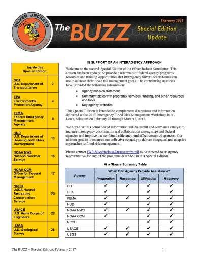
8 MULTIPLE AGENCY RESOURCES Special Edition February 2017

 -Nonstructural flood risk mgt interagency projects * Contingent on")
9 USACE COMMITMENT TO SILVER JACKETS TEAMS Staff - Lead USACE District One Door to the Corps - Technical / Planning Assistance Information Sharing and Collaboration - Quarterly newsletter The BUZZ - Webinars - Interagency Workshops Program Support* -Planning and technical assistance -Engineering design & construction (cost shared) -Nonstructural flood risk mgt interagency projects * Contingent on Congressional appropriations.
10 INTERAGENCY PROJECTS Promote USACE participation in small interagency projects with partners to achieve flood risk management benefits that could not be achieved by one party. USACE funded through existing programs (FPMS - FCCE) NOT A GRANT: Funds USACE planning guidance / technical assistance Focus on non-structural flood risk management strategies (i.e. adapts structures and behaviors to natural characteristics of flooding) Leverages resources/authorities in coordination with other partners
11 SELECTION CRITERIA Protects life safety, reduces or prevents increases in flood risk, and/or increases resiliency. Promotes shared responsibility for flood risk management. Addresses priority in State or Local Hazard Mitigation Plan. Leverages partner resources in collaboration with partners.
12 Flood Objective Outcomes: Progression from Awareness to Action Raise flood risk awareness. 25% projects Prompt flood risk action. 40% projects Reduce or manage flood risk. 35% projects Other Outcomes Results in non-monetary social benefits. 75% projects Improves environmental function. 18% projects Data reflects projects initiated

13 HOW PARTNERING WORKS FEMA Developed HEC-RAS model for DFIRM. NOAA NWS Provides flood forecast data. Links to maps on NOAA/NWS webpage. USACE Surveys cross sections. Updates existing FEMA developed HEC-RAS model with new survey data. USGS Models range of flood flows using updated HEC-RAS model. Develops inundation maps. Uploads to USGS FIM Mapper webpage. State Conducts public outreach activities with community. Identifies opportunities to manage or reduce risk. Local Community Conducts public outreach activities. Updates local HMP.
14 Percentage of Projects PROJECT PARTNERS (FY ) Partner Participation in Interagency Projects Total projects = 280 Other Federal - BIA, BLM, EPA, HUD, FHWA, NOAA OCM, NPS, NRCS, TVA, USBM, USBR, USFS, USFWS
15 INTERAGENCY PROJECT TYPES ( ) Data Management 8% ~280 Total Planning Analysis 34% Outreach/ Education 26% Preparedness 11% Mapping 21% Projects in 47 States and District of Columbia

16 LOUISIANA SILVER JACKETS IN ACTION CITY OF NEW ORLEANS GREEN INFRASTRUCTURE WATER MGT Update Storm Water Mgt Model (SWMM) Identify Green Infrastructure opportunities to reduce flood stage In progress Partners City of New Orleans Sewerage & Water Board of New Orleans State of LA Tulane University EPA USACE Estimated Cost Total = $410 K USACE = $100 K


17 MAINE SILVER JACKETS IN ACTION HYDRAULIC STRUCTURES FAILURE ANALYSIS Analysis for ~ 500 hydraulic structures 21 communities 10, 4, 2, & 1-percent chance flood events Partners MDOT ME Office of GIS FEMA USFWS USACE Estimated Cost Total = $131 K USACE = $40 K


18 IDAHO SILVER JACKETS IN ACTION SO, YOU RE A FLOODPLAIN MANAGER? Resource guide for new community floodplain administrators with short orientation video, templates and other information. Partners IDWR IOEM FEMA HUD NOAA NWS NRCS USBR USGS USACE Estimated Cost Total = $79 K USACE = $67 K


19 NEVADA SILVER JACKETS IN ACTION FLOOD FIGHTER VIDEO GAME Partners NV DWR NV DCN&R NV EPA USACE Estimated Cost Total = $280K USACE = $170K

20 SOUTH CAROLINA SILVER JACKETS IN ACTION MAPPING COASTAL EROSION HAZARDS ALONG SHELTERED COASTLINES Partners SC DHEC NOAA OCM NOAA Sea Grant USACE Estimated Cost Total = $385 K USACE = $98 K


21 MN / ND SILVER JACKETS IN ACTION EMERGENCY ACTION PLAN GUIDEBOOK & WORKSHOPS Templates and Forms - After Action Review - Contacts - Personnel List - Critical Facilities - Hazardous Materials - Record of Plan Distribution - Press Release Example Partners MN and ND Emergency Mgrs FEMA NOAA NWS USGS USACE - Organization Chart Estimated Cost Total = $140 K USACE = $75 K Download from USACE St. Paul District s website:

22 CALIFORNIA SILVER JACKETS IN ACTION REGIONAL SUMMARIES OF LOCAL HAZARD MITIGATION PLANS Develop regional consolidated database of mitigation projects identified in 58 county LHMPs. Partners CA DWR Cal OES FEMA USACE Estimated Cost Total = $610K USACE = $100K


23 ILLINOIS SILVER JACKETS IN ACTION MOBILE INFORMATION COLLECTION APPLICATION (MICA) Log-in accessible real-time flood data collection tool, using mobile devices Adding capabilities - sketch tool, photo geo-location documentation, data storage and retrieval Partners IL DNR IL EMA 15 IL Counties FEMA NOAA NWS USACE Estimated Cost Total = $270 K USACE = $170 K


24 SEARCHABLE INTERAGENCY PROJECT TABLE 24 Example Project Summary Poster File Name
25 PROPOSALS FOR FY18 INTERAGENCY PROJECTS Proposals due 11 July 2017 Three (3) per state Max. $100K per proposal Selections made Sept 2017 Initial funds available Oct 2017 Projects must be completed in months

26 HOW DO I GET INVOLVED WITH A SILVER JACKETS TEAM? USACE State Team POC USACE Silver Jackets Web Site: OR National Silver Jackets Program Ellen Berggren Deputy, National Silver Program Ellen.M.Berggren@usace.army.mil
Silver Jackets - Flood Risk Management Program
 COOPERATING TECHNICAL PARTNER INFORMATION EXCHANGE Silver Jackets - Flood Risk Management Program August 31, 2017 Association of State Floodplain Managers AUDIO AND WEB SETTINGS Your Participation Open
SILVER JACKETS INTERAGENCY PROJECT POST-WILDFIRE GUIDE. Rachael Orellana, PE. Jeremy Lancaster, CEG
 SILVER JACKETS INTERAGENCY PROJECT 237 237 237 217 217 217 200 200 200 80 119 27 252 174.59 POST-WILDFIRE GUIDE 255 255 255 0 0 0 163 163 163 131 132 122 Rachael Orellana, PE 239 65 53 Flood Risk Program
Improving Coordinated Flood Preparedness and Response
 Improving Coordinated Flood Preparedness and Response Illinois Silver Jackets Hank DeHaan Rock Island and Saint Louis Districts October 2011 US Army Corps of Engineers Illinois Silver Jackets Program Illinois
Action Items for Flood Risk Management on Wildcat Creek Interagency success with floodplain management plans and flood forecast inundation maps
 Presentation to USACE 2012 Flood Risk Management and Silver Jackets Joint Workshop, Harrisburg, Pennsylvania Action Items for Flood Risk Management on Wildcat Creek Interagency success with floodplain
CA AND NV SILVER JACKETS TEAM MEETING
 CA AND NV SILVER JACKETS TEAM MEETING 1 255 255 255 237 237 237 0 0 0 217 217 217 163 163 163 200 200 200 131 132 122 239 65 53 80 119 27 110 135 120 252 174.59 SEPTEMBER 8, 2017 Mary Jimenez, P.E. Maria
GAFM Showcase: Multiple Agencies Combating Georgia s Flood Risk Together: Proven Results Gained by Strong Partnerships
 National Flood Insurance Program Participation GAFM Showcase: Multiple Agencies Combating Georgia s Flood Risk Together: Proven Results Gained by Strong Partnerships Moderator: Jill Bazinet, PE, CFM GAFM
Silver Jackets Non-Structural Solutions Anthony Heddlesten, P.E., CFM Peoria Flood Area Engineer USACE, Rock Island District 10/16/2015
 Silver Jackets Non-Structural Solutions Anthony Heddlesten, P.E., CFM Peoria Flood Area Engineer USACE, Rock Island District 10/16/2015 US Army Corps of Engineers Good Morning! Thanks for starting your
USACE Silver Jackets, the Missouri State Risk Management Team and State Hazard Mitigation
 MfSMA Conference, State Risk Management Team Meeting Things You Want To Know USACE Silver Jackets, the Missouri State Risk Management Team and State Hazard Mitigation Brian Rast, PE, CFM, PMP Silver Jackets
National Flood Risk Management Program
 National Flood Risk Management Program US Army Corps of Engineers Floodplain Managers Association Sacramento, California July 29, 2010 Judy Soutiere Institute for Water Resources A Shared Responsibility
Interagency Nonstructural Flood Risk Management Workshop. Carey Johnson Kentucky Division of Water
 Interagency Nonstructural Flood Risk Management Workshop Carey Johnson Kentucky Division of Water Nonstructural Flood Risk Management Nonstructural floodproofing Elevation Relocation Buyout/acquisition
USACE Support to Interagency Projects What Is Funded & Why?
 USACE Support to Interagency Projects What Is Funded & Why? Lisa Bourget, P.E. Senior Water Resources Engineer Jennifer Dunn, CFM Silver Jackets Program USACE, Institute for Water Resources June 4, 2015
Georgia Silver Jackets Team
 Georgia Silver Jackets Team 9 th Annual GAFM Technical Conference Jeff Morris GA SJ Collaborator Savannah District, USACE US Army Corps of Engineers SMART GOVERNMENT Integrate and synchronize flood risk
ASFPM RECOMMENDED TASK FORCE ACTIONS
 Association of State Floodplain Managers, Inc. 2809 Fish Hatchery Road, Suite 204, Madison, WI 53713 Phone: 608-274-0123 Fax: 608-274-0696 Website: www.floods.org Email: asfpm@floods.org Federal Interagency
ENGINEERING AND CONSTRUCTION BULLETIN
 ENGINEERING AND CONSTRUCTION BULLETIN No. 2016-8 Issuing Office: CECW-CE Issued: 22 Feb 16 Expires: 22 Feb 18 SUBJECT: Interim Risk Reduction Measures (IRRMs) for Levee Safety CATEGORY: Directive and Policy
Authors: Terry Zien, Brian Rast and the Silver Jackets Co presenters: Brian Rast, Dave Lupardus and Frank Dolan
 Authors: Terry Zien, Brian Rast and the Silver Jackets Co presenters: Brian Rast, Dave Lupardus and Frank Dolan http://www.mvp.usace.army.mil/missions/civilworks/floodriskm anagement/emergencyactionplanguidebook.aspx
North Atlantic Coast Comprehensive Study: Resilient Adaption to Increasing Risk
 North Atlantic Coast Comprehensive Study: Resilient Adaption to Increasing Risk U.S. Army Corps of Engineers Coastal Storm Risk Management Planning Center of Expertise Amy M. Guise, USACE 21 November 2013
Flood Risk Outreach Tools for Georgia Communities. GAFM 10 th Annual Conference Presented By: Jarrett Mattli
 Flood Risk Outreach Tools for Georgia Communities GAFM 10 th Annual Conference Presented By: Jarrett Mattli April 13, 2016 Presentation Overview Guidebooks Toolkits Templates Educational Videos Resource
Washington, DC Silver Jackets. DC Silver Jackets Team: Working Together to Manage Flood Risk in our Nation s Capital 2018 ANNUAL REPORT
 Washington, DC Silver Jackets DC Silver Jackets Team: Working Together to Manage Flood Risk in our Nation s Capital 2018 ANNUAL REPORT Above Image: Side Image: November 1, 2018 Team Meeting at the DC Armory
Northwest Flood Fight Workshops
 Northwest Flood Fight Workshops September 24, 2014 IWR Webinar D. Leslie Miller, P.E. (Les) Flood Preparedness Program Manager US Army Corps of Engineers, Portland District US Army Corps of Engineers Welcome
A Flood Mitigation Plan for the Non-Tidal N.J. Section of the Delaware River Basin. Mercer County Kick-off Meeting December 6, 2006
 A Flood Mitigation Plan for the Non-Tidal N.J. Section of the Delaware River Basin Mercer County Kick-off Meeting December 6, 2006 The Delaware River. crosses many boundaries Four states: DE, PA, NJ, NY
April 3, 4, & 5, 2017 Pittsburgh, Butler, Erie Western PA
 April 3, 4, & 5, 2017 Pittsburgh, Butler, Erie Western PA 2 Hazard Mitigation is: any cost-effective action taken to eliminate or reduce the long term risk to life and property from natural and technological
National Coastal Outreach
 National Coastal Outreach Answering Tough Questions June 11, 2013 Why Focus on Coastal Flood Risk? 120,475,000 people or 39% of the U.S. population live in counties subject to the 1% annual chance coastal
NFIP Program Basics. KAMM Regional Training
 NFIP Program Basics KAMM Regional Training Floodplain 101 Homeowners insurance does not cover flood damage Approximately 25,000 flood insurance policies in KY According to BW12 analysis, approximately
Vocabulary of Flood Risk Management Terms
 USACE INSTITUTE FOR WATER RESOURCES Vocabulary of Flood Risk Management Terms Appendix A Leonard Shabman, Paul Scodari, Douglas Woolley, and Carolyn Kousky May 2014 2014-R-02 This is an appendix to: L.
Flood Risk After Wildfires: A Multi-Agency Approach
 Flood Risk After Wildfires: A Multi-Agency Approach Achieving Flood Risk Management Through Integration Levee Safety Program Provides Training and Coaching Resources Digital Flood Insurance Rate Maps for
This survey is expected to take approximately 20 minutes and must be completed in one session.
 State Flood Assessment Survey 1 Introduction Thank you for your willingness to participate in this online survey as part of the State Flood Assessment effort. This first step toward developing comprehensive
Floodplain Management Services Baltimore District Studies
 Floodplain Management Services Baltimore District Studies FACT SHEET as of December 31, 2014 AUTHORIZATION: Floodplain Management Services (FPMS) TYPE OF PROJECT: Flood Risk Management (Technical Services)
Attachment B. King County Flood Control Zone District Work Program
 Attachment B King County Flood Control Zone District Work Program The King County Flood Control Zone District work program is comprised of two major categories: Programmatic Work Program o Flood Preparedness,
Joint Recommendations on Levee Policy. Association of State Floodplain Managers. National Association of Flood and Stormwater Management Agencies
 Joint Recommendations on Levee Policy developed by the Association of State Floodplain Managers and the National Association of Flood and Stormwater Management Agencies from discussions at the Flood Risk
Findings/Debrief Meeting September 9, CDOT R4 Headquarters Big Thompson Conference Room W 10 th St. Greeley, CO 80634
 Findings/Debrief Meeting September 9, 2016 CDOT R4 Headquarters Big Thompson Conference Room 10601 W 10 th St. Greeley, CO 80634 Discovery Review & Outcome May 25 Discovery Meeting Summary Summarize Data
ASFPM Partnerships for Statewide Mitigation Actions. Alicia Williams GIS and HMP Section Manager, Amec Foster Wheeler June 2016
 ASFPM Partnerships for Statewide Mitigation Actions Alicia Williams GIS and HMP Section Manager, Amec Foster Wheeler June 2016 Summary The Concept Leveraging Existing Data and Partnerships to reduce risk
Kentucky Risk MAP It s not Map Mod II
 Kentucky Risk MAP It s not Map Mod II Risk Mapping Assessment and Planning Carey Johnson Kentucky Division of Water carey.johnson@ky.gov What is Risk MAP? Risk Mapping, Assessment, and Planning (Risk MAP)
A Little Less Conversation a Little More ACTION! Louie Greenwell, GISP, CFM T&M Associates Carey Johnson KY Division of Water
 A Little Less Conversation a Little More ACTION! Louie Greenwell, GISP, CFM T&M Associates Carey Johnson KY Division of Water Topics Covered It s all about ACTION! Kentucky s plan for delivering actions
This survey is expected to take approximately 20 minutes and must be completed in one session.
 Introduction Thank you for your willingness to participate in this online survey as part of the State Flood Assessment effort. This first step toward developing comprehensive flood planning for Texas does
Federal Emergency Management Agency Update. Jesse F. Munoz, CEM Director Mitigation Division Region IV
 Federal Emergency Management Agency Update Jesse F. Munoz, CEM Director Mitigation Division Region IV To support our citizens and first responders to ensure that as a nation we work together to build,
A Flood Mitigation Plan for the Non-Tidal N.J. Section of the Delaware River Basin. Warren County Planning Workshop (2 nd Meeting) March 7, 2007
 March 7, 2007") A Flood Mitigation Plan for the Non-Tidal N.J. Section of the Delaware River Basin Warren County Planning Workshop (2 nd Meeting) March 7, 2007 Study Area Participation: Hunterdon: 16 Eligible Municipalities
A Flood Mitigation Plan for the Non-Tidal N.J. Section of the Delaware River Basin Warren County Planning Workshop (2 nd Meeting) March 7, 2007 Study Area Participation: Hunterdon: 16 Eligible Municipalities
King County Flood Control District 2015 Work Program
 Attachment A 2015 Work Plan 10-24-14 King County Flood Control District 2015 Work Program The District work program is comprised of three categories: district oversight and policy development, operations,
Flood Smart Communities
 Flood Smart Communities Stevie Adams, Freshwater Specialist, The Nature Conservancy Funding provided by NOAA Coastal Storms Program through Ohio Sea Grant To conserve the lands and waters on which all
MUNICIPAL LAND USE STRATEGIES for Improving Flood Resilience
 MUNICIPAL LAND USE STRATEGIES for Improving Flood Resilience Strategy for a Flood Resistant Southern Tier Central Region (LWRP project) This presentation was prepared by Southern Tier Central Regional
King County Flood Control District Flood Risk Reduction Work Program and Accomplishments
 King County Flood Control District Flood Risk Reduction Work Program and Accomplishments Brian Murray Water and Land Resources Division April 26, 2016 Department of Natural Resources and Parks Water and
Flood Risk Products. New Techniques for Identifying and Communicating Flood Risk
 Flood Risk Products New Techniques for Identifying and Communicating Flood Risk Mark Zito, GISP, CFM GIS Specialist Amol Daxikar, GISP, CFM Project Manager March 28, 2012 1% Flood with 3 Feet Sea Level
CNMS and FOA: A Year in Review. Rick Sacbibit, P.E. Andy Read, CFM FEMA HQ, Risk Analysis Division June 4, 2015
 CNMS and FOA: A Year in Review Rick Sacbibit, P.E. Andy Read, CFM FEMA HQ, Risk Analysis Division June 4, 2015 Overview Current NVUE Status NVUE Cliff Update on CNMS Web Viewer CNMS Guidance Updates FOA
ASFPM REGION 7 DIRECTOR ANNUAL REPORT. Annual Conference-Atlanta, Georgia
 ASFPM REGION 7 DIRECTOR ANNUAL REPORT Annual Conference-Atlanta, Georgia Shanna Michael ASFPM REGION 7 DIRECTOR ANNUAL REPORT Annual Conference-Atlanta, Georgia Region 7 encompasses Iowa, Kansas, Missouri,
Michael Taylor, PE, CFM Project Manager, AECOM August 25, 2015
 Promoting FEMA s Flood Risk Products in the Lower Levisa Watershed Michael Taylor, PE, CFM Project Manager, AECOM August 25, 2015 Agenda Study Background Flood Risk Product Overview AOMI and Mitigation
Piloting LAMP from Stream to Sea
 Piloting LAMP from Stream to Sea FEMA s New Analysis and Mapping Procedures for Non-Accredited Levee Systems Presented by: Eric Simmons, CFM Senior Engineer, FEMA Region IX Presentation Outline Levee Issues
in coordination with Peoria County, Planning and Zoning Department
 Prepared by Amec Foster Wheeler Environment & Infrastructure Hazard Mitigation and Emergency Management Program in coordination with Peoria County, Planning and Zoning Department The purpose of hazard
Flood Plain Management Services (FPMS) Program
 Program") Flood Plain Management Services (FPMS) Program 2016 Winter Stakeholder Partnering Forum March 2016 Mario Beddingfield, P.E., CFM Hydraulic Engineer/FPMS Program Manager H&H/Water Control Branch U.S. Army
Flood Plain Management Services (FPMS) Program 2016 Winter Stakeholder Partnering Forum March 2016 Mario Beddingfield, P.E., CFM Hydraulic Engineer/FPMS Program Manager H&H/Water Control Branch U.S. Army
David A. Stroud, CFM AMEC Earth & Environmental Raleigh, NC
 David A. Stroud, CFM AMEC Earth & Environmental Raleigh, NC Objectives Risk MAP background North Carolina s Risk MAP role Role of communication in Risk MAP Effective risk communication two examples Multi-hazard
A Flood Mitigation Plan for the Non-Tidal N.J. Section of the Delaware River Basin. Sussex County Kick-off Meeting November 28, 2006
 A Flood Mitigation Plan for the Non-Tidal N.J. Section of the Delaware River Basin Sussex County Kick-off Meeting November 28, 2006 The Delaware River. crosses many boundaries Four states: DE, PA, NJ,
Flood Risk and Climate Adaptation: Policy Reforms and Lessons (Being) Learned from Hurricane Sandy
 Learned from Hurricane Sandy") Flood Risk and Climate Adaptation: Policy Reforms and Lessons (Being) Learned from Hurricane Sandy Adaptive Planning For Coastal Change: Legal Issues For Local Government Briefing Overview 2 Background:
Flood Risk and Climate Adaptation: Policy Reforms and Lessons (Being) Learned from Hurricane Sandy Adaptive Planning For Coastal Change: Legal Issues For Local Government Briefing Overview 2 Background:
EMERGENCY ACTION PLAN GUIDEBOOK
 EMERGENCY ACTION PLAN GUIDEBOOK Presented by: Terry Zien and Bonnie Greenleaf US Army Corps of Engineers Background Purpose Overview of Guidebook Discussion of Key Chapters Minnesota Silver Jackets Natural
Table 1: Federal, State and Local Government Rules applicable to LOMRs/CLOMRS submittal
 MnDNR LOMC Guide This document has been prepared by the Minnesota Department of Natural Resources floodplain staff and is intended to provide assistance with LOMR/CLOMR submittals. This information is
Meeting the Nation s Levee Challenges
 ASDSO USACE/FEMA Levee Discussion Meeting the Nation s Levee Challenges November 2015 Presenters: Richard Varuso, USACE Michael Bishop, FEMA 1 This Session s Objective KNOWLEDGE - Provide you with insight
Cameron County, TX. Consultation Coordination Officer (CCO) Meeting. Please sign in (sheet at front of the room) Meeting will begin at 9:00
 Meeting. Please sign in (sheet at front of the room) Meeting will begin at 9:00") Cameron County, TX Consultation Coordination Officer (CCO) Meeting Please sign in (sheet at front of the room) Meeting will begin at 9:00 July 29, 2015 Lisa Jennings FEMA Region 6 Roles & Responsibilities
Cameron County, TX Consultation Coordination Officer (CCO) Meeting Please sign in (sheet at front of the room) Meeting will begin at 9:00 July 29, 2015 Lisa Jennings FEMA Region 6 Roles & Responsibilities
FEMA s Flood Map Modernization Preparing for FY09 and Beyond: Integrated Flood Data Update, Risk Assessment, and Mitigation Planning
 FEMA s Flood Map Modernization Preparing for FY09 and Beyond: Integrated Flood Data Update, Risk Assessment, and Mitigation Planning DRAFT CONCEPT PAPER June 1, 2007 Integrated Flood Data Update, Risk
Mapping Flood Risk in the Upper Fox River Basin:
 Mapping Flood Risk in the Upper Fox River Basin: Vulnerable Populations and Adverse Health Effects Presented by: Angelina Hanson STUDY AREA: Wisconsin's Upper Fox River Basin Total Population 139,309.
Non Regulatory Risk MAP Products Flood Depth and Probability Grids
 Non Regulatory Risk MAP Products Flood Depth and Probability Grids Virginia Floodplain Management Association 2015 Floodplain Management Workshop October 29th, 2015 Nabil Ghalayini, P.E., PMP, D.WRE, CFM
FLOODPLAIN MANAGEMENT PLAN 2015 ANNUAL PROGRESS REPORT
 FLOODPLAIN MANAGEMENT PLAN 2015 ANNUAL PROGRESS REPORT Hinds County (Unincorporated) NFIP Community Number 280070 The 2015 Floodplain Management Plan Annual Progress Report on the progress made in implementing
National Flood Risk Management Program
 National Flood Risk Management Program Program Management Plan 2 July 2012 US Army Corps of Engineers BUILDING STRONG Page Left Intentionally Blank. FRM Program Management Plan 2 July 2012 2 TABLE OF CONTENTS
Community Rating System. National Flood Insurance Program
 National Flood Insurance Program Community Rating System A Local Official s Guide to Saving Lives Preventing Property Damage Reducing the Cost of Flood Insurance FEMA B-573 / May 2015 How the Community
CITY OF PLANTATION ENGINEERING DEPARTMENT INTEROFFICE MEMORANDUM NO
 CITY OF PLANTATION ENGINEERING DEPARTMENT INTEROFFICE MEMORANDUM NO. 2013-003 DATE: October 22, 2012 TO: Mayor and Members of City Council FROM: Brett W. Butler, PE, CFM City Engineer SUBJECT: CRS Program
Delaware River Basin Commission s Role in Flood Loss Reduction Efforts
 Delaware River Basin Commission s Role in Flood Loss Reduction Efforts There is a strong need to reduce flood vulnerability and damages in the Delaware River Basin. This paper presents the ongoing role
Improving Flood Hazard Identification & Flood Risk Communication: Lessons Learned from Dam Failures in South Carolina
 Improving Flood Hazard Identification & Flood Risk Communication: Lessons Learned from Dam Failures in South Carolina Katy Goolsby-Brown June 23, 2016 1 Dam Failure Incidents in South Carolina SC Dam Failures
TESTIMONY. Association of State Floodplain Managers, Inc. Subcommittee on Transportation and Infrastructure
 ASSOCIATION OF STATE FLOODPLAIN MANAGERS, INC. 2809 Fish Hatchery Road, Suite 204, Madison, Wisconsin 53713 www.floods.org Phone: 608-274-0123 Fax: 608-274-0696 Email: asfpm@floods.org TESTIMONY Association
Section 19: Basin-Wide Mitigation Action Plans
 Section 19: Basin-Wide Mitigation Action Plans Contents Introduction...19-1 Texas Colorado River Floodplain Coalition Mitigation Actions...19-2 Mitigation Actions...19-9 Introduction This Mitigation Plan,
Flood Risk Resilience in Alabama: Challenges and Successes
 Flood Risk Resilience in Alabama: Challenges and Successes Leslie A. Durham, P.E. Floodplain Management Branch Chief Alabama Office of Water Resources 10 Year Partnership with FEMA Flood Map Modernization
Cumberland County, NJ. Risk MAP Project Status Update April 22, 2013
 Cumberland County, NJ Risk MAP Project Status Update April 22, 2013 Agenda Project Team Milestones Risk MAP Overview Study Scope overview Regulatory products Non-regulatory products Proposed Schedule Risk
CONTINUING AUTHORITIES PROJECT (CAP) Federal Interest Determination
 Federal Interest Determination") Date: 8 May 2013 Division: Great Lakes and Ohio River Division District: Nashville District CONTINUING AUTHORITIES PROJECT (CAP) Federal Interest Determination 1. Project: Cumberland River, Metropolitan
Date: 8 May 2013 Division: Great Lakes and Ohio River Division District: Nashville District CONTINUING AUTHORITIES PROJECT (CAP) Federal Interest Determination 1. Project: Cumberland River, Metropolitan
Natchitoches Parish, Louisiana Flood Insurance Study Update Risk Analysis March 3, Shona Gibson Project Monitor, FEMA Region VI
 Natchitoches Parish, Louisiana Flood Insurance Study Update Risk Analysis Shona Gibson Project Monitor, FEMA Region VI Presentation Overview Introductions Why are we here? Levee Status and Opportunities
Chapter 7 Appendix B: National Flood Insurance Program Summary for Kaua'i County, 2015 Update
 Chapter 7 Appendix B: National Flood Insurance Program Summary for Kaua'i County, 2015 Update Topic Considerations Description INSURANCE SUMMARY STAFF RESOURCES How many NFIP policies are in Kaua i County?
IN THE LITTLE APPLE A PRESENTATION FOR THE 2017 ASFPM ANNUAL CONFERENCE IN KANSAS CITY, MO, MANAGING FLOOD RISK IN THE HEARTLAND
 A PRESENTATION FOR THE 2017 ASFPM ANNUAL CONFERENCE IN KANSAS CITY, MO, MANAGING FLOOD RISK IN THE HEARTLAND NONSTRUCTURAL 237 217 200 ASSESSMENT 80 252 237 217 200 119 174 237 217 200 27.59 IN THE LITTLE
CONGRESSIONAL DISTRICT: IN 03
 CONGRESSIONAL DISTRICT: IN 03 80 Steuben Lagrange Angola 69 Kendallville DeKalb Noble Garrett Auburn Kosciusko Warsaw Dam Safety Program (All COE Indiana Dams) Columbia City Allen Whitley Fort Wayne New
Flood Risk in the Schuylkill Watershed. Planning for Resilient Communities
 Flood Risk in the Schuylkill Watershed Planning for Resilient Communities Welcome to Our Poster Session! We are here to talk about: Flood Risk in the Schuylkill River Watershed Taking Action to Reduce
Georgia Flood M.A.P. Program Risk MAP Plenary Session GAFM 2011
 Georgia Flood M.A.P. Program Risk MAP Plenary Session GAFM 2011 Collis Brown, Georgia DNR March 24, 2011 GA Flood Map Modernization Responsible for end-to-end production Developed aggressive outreach program
Outreach Georgia Flood M.A.P. Program. GAFM Technical Conference Flood Risk Outreach and Policy Session
 Outreach Georgia Flood M.A.P. Program GAFM Technical Conference Flood Risk Outreach and Policy Session 7 th Annual Technical Conference, Lanier Islands March 29, 2012 Risk Communication Key Learnings People
FLOOD INUNDATION MAPPING SCIENCE. Gardner Bent, U.S. Geological Survey, New England Water Science Center
 FLOOD INUNDATION MAPPING SCIENCE Gardner Bent, U.S. Geological Survey, New England Water Science Center What is Flood Inundation Mapping? Flood Inundation Mapping (FIM) is a real-time, operational tool
SECTION 6: MITIGATION STRATEGIES
 SECTION 6: MITIGATION STRATEGIES This section presents mitigation actions for Somerset County to reduce potential exposure and losses identified as concerns in the Risk Assessment portion of this plan.
10/5/2015. What Makes a Sound Floodplain Management Program? What are the Flood Problems in your Community?
 The Community Rating System (CRS) and Hazard Mitigation Planning Preparing Your Community Through Common Program Goals September 3, 2015 What Makes a Sound Floodplain Management Program? Know your community
Executive Director Deputy Director Director Emeritus Chad M. Berginnis, CFM Ingrid D. Wadsworth, CFM Larry A. Larson, P.E., CFM
 ASSOCIATION OF STATE FLOODPLAIN MANAGERS, INC. 575 D Onofrio Drive, Suite 200, Madison, Wisconsin 53719 www.floods.org Phone: 608-828-3000 Fax: 608-828-6319 asfpm@floods.org www.floods.org Executive Director
Bucks County, PA Flood Risk Review Meeting. November 2014
 Bucks County, PA Flood Risk Review Meeting November 2014 Agenda for Today Risk MAP Program overview Overview of non-regulatory Flood Risk Products and datasets Discuss mitigation action Technical overview
Floodplain Management Plan
 Floodplain Management Plan CITY OF FORT WORTH TFMA 2016 Spring Conference March 10, 2016 Agenda 1. Fort Worth Higher Standards (NFIP & CRS) 2. Floodplain Management Plan Overview and Results 3. Project
HAZARD MITIGATION PLAN POINT OF CONTACT MUNICIPAL PROFILE
 HAZARD MITIGATION PLAN POINT OF CONTACT stockpolice@rcn.com stockworks@rcn.com MUNICIPAL PROFILE MUNICIPAL PARTICIPATION Compliance with the National Flood Insurance Program (NFIP) Identify source of information,
The Breadth of the Planning Portfolio
 The Breadth of the Planning Portfolio Travis Creel, Planner, Regional Planning and Environmental Division South, MVD Eric Halpin, Special Assistant for Dam and Levee Safety, HQUSACE Lisa Kiefel, PCoP,
Overview of Capabilities and Current Limitations
 Overview of Capabilities and Current Limitations Overview of the National Flood Risk Characterization Tool (NFRCT) Map based viewer of relative flood risk around the U.S., with supporting reports for more
CRISP COUNTY, GEORGIA AND INCORPORATED AREAS
 CRISP COUNTY, GEORGIA AND INCORPORATED AREAS Community Name Community Number ARABI, CITY OF 130514 CORDELE, CITY OF 130214 CRISP COUNTY (UNINCORPORATED AREAS) 130504 Crisp County EFFECTIVE: SEPTEMBER 25,
Delaware Bay / River Coastal Flood Risk Study. FEMA REGION II and III September 19, 2012
 Delaware Bay / River Coastal Flood Risk Study FEMA REGION II and III September 19, 2012 Agenda Risk MAP Program Overview Risk MAP Non-Regulatory Products & Datasets Region II New Jersey Coastal Flood Study
The Community Rating System in Coastal New England: Regional Approaches and Lessons Learned
 Session 4: Flood Insurance and the Community Rating System The Community Rating System in Coastal New England: Regional Approaches and Lessons Learned Abbie Sherwin - Maine Coastal Program Julie LaBranche
National Capitol Region HAZUS User Group Call
 Listen to the recording here to follow along with the presentation: http://www.freeconferencecalling.com/recordings/recording.aspx?fileid=l AF3494_04252013070630062_1154707&bridge=697620&email=&account
Vision to Action: Creating and Using a Flood Risk Assessment for Identifying Mitigation Options
 Vision to Action: Creating and Using a Flood Risk Assessment for Identifying Mitigation Options Lisa Graff, CFM, GISP Clayton Ballerine, CFM Brad McVay, CFM, GISP University of Illinois Prairie Research
HAZARD MITIGATION PLAN POINT OF CONTACT. MUNICIPAL PROFILE
 HAZARD MITIGATION PLAN POINT OF CONTACT alacko@walnutportpa.org MUNICIPAL PROFILE MUNICIPAL PARTICIPATION Compliance with the National Flood Insurance Program (NFIP) Topic 1. Staff Resources Is the Community
ASFPM REGION 6 DIRECTOR ANNUAL REPORT. Annual Conference-Atlanta, Georgia
 ASFPM REGION 6 DIRECTOR ANNUAL REPORT Annual Conference-Atlanta, Georgia Jessica Baker, Regional Director 5/31/2015 ASFPM REGION 6 DIRECTOR ANNUAL REPORT Annual Conference-Atlanta, Georgia Region 6 Report
ASFPM Update OUR CHALLENGE. Floods are 'acts of God,' but flood losses are largely acts of man. Fall, 2016
 ASFPM Update Fall, 2016 OUR CHALLENGE Floods are 'acts of God,' but flood losses are largely acts of man. 1945 PhD Dissertation Human Adjustments to Flood by Gilbert F. White 1 OUR CHALLENGE Credit: Chopperguy
Community Resilience & NFIP s Community Rating system
 Community Resilience & NFIP s Community Rating system Ajita Atreya Wharton Risk Management and Decision Processes Center University of Pennsylvania National Association of Counties (NACo) Session on Risk
Oklahoma High Water Marks. CTP Community of Practice April 20, 2017
 Oklahoma High Water Marks CTP Community of Practice April 20, 2017 The Rains Came into Region 6 in May 2015 2 Disaster DR-4222 30 Day Rainfall 3 NOAA Rainfall Amounts / Rainfall Frequency 4 The Rains in
Georgia Flood M.A.P. Program
 Georgia Flood M.A.P. Program Georgia Flood M.A.P. Program The Upper Chattahoochee River Basin Risk MAP Project Transitioning State Program to align with FEMA s Risk MAP Program Increase focus on risk assessment
Moving Policy and Practice from Flood and Coastal Storm Damage Reduction to Risk Management
 Moving Policy and Practice from Flood and Coastal Storm Damage Reduction to Risk Management and other words of encouragement for my friends in the Planning CoP Eric Halpin, PE Special Assistant for Dam
ASFPM Update. GAFM 10 th Annual Technical Conference March 24, 2016
 ASFPM Update GAFM 10 th Annual Technical Conference March 24, 2016 AND HE SAID Floods are 'acts of God,' but flood losses are largely acts of man. 1945 PhD Dissertation Human Adjustments to Flood by Gilbert
FLOOD STUDY Atlantic County, NJ. FEMA REGION II July 12, :00
 FLOOD STUDY Atlantic County, NJ FEMA REGION II July 12, 2011 14:00 Agenda Introductions FEMA Strategic Plan & Risk Mapping, Assessment, and Planning (Risk MAP) Goals Risk MAP Program Overview Meeting Objectives
HAZARD MITIGATION PLAN POINT OF CONTACT MUNICIPAL PROFILE
 HAZARD MITIGATION PLAN POINT OF CONTACT louise@windgap-pa.gov jeffreyyob@gmail.com MUNICIPAL PROFILE MUNICIPAL PARTICIPATION Compliance with the National Flood Insurance Program (NFIP) Identify source
SOUTH CENTRAL REGION MULTI-JURISDICTION HAZARD MITIGATION PLAN. Advisory Committee Meeting September 12, 2012
 SOUTH CENTRAL REGION MULTI-JURISDICTION HAZARD MITIGATION PLAN Advisory Committee Meeting September 12, 2012 AGENDA FOR TODAY Purpose of Meeting Engage All Advisory Committee Members Distribute Project