Flood Risk in the Schuylkill Watershed. Planning for Resilient Communities
|
|
|
- August Stanley
- 5 years ago
- Views:
Transcription


1 Flood Risk in the Schuylkill Watershed Planning for Resilient Communities
2 Welcome to Our Poster Session! We are here to talk about: Flood Risk in the Schuylkill River Watershed Taking Action to Reduce Impacts from Flooding Building Resilient Communities 2

3 Do You Know Your Flood Risk? And there are 1731 miles of mapped floodplain in the Schuylkill River watershed alone! 3
4 Where Does Flooding Occur? Almost Anywhere! Fact: ~25% of all National Flood Insurance Program (NFIP) claims occur outside of mapped floodplains! To learn more about the NFIP, go to: 4
5 Flood Risk Factors in the Schuylkill Watershed Our Poster Session Map shows locations of: 5
6 Flood Risk Severity in $ We ve color-coded Flood Risk in the watershed by severity The colors represent levels of economic impact due to flooding (ranging from Very Low to Very High) 6
7 Examples of Flood Risk in the Schuylkill River Watershed Significant land use changes causing increased run-off and flooding Felix Dam Breach And Removal Bernville Levee Others 7

8 Know Your Risk FEMA s Regulatory Products FEMA s Flood Insurance Rate Maps (FIRMs) Flood Insurance Study Reports GIS Database of Flood Layers DFIRM Database Products used for floodplain management and insurance purposes as part of the National Flood Insurance Program (NFIP) 8

 Flood Risk")


9 Know Your Risk FEMA s Flood Risk Products FEMA s Flood Risk Map (FRM) Flood Risk Report GIS Database of Flood Risk Data Use for Flood Risk Mitigation Planning 9

10 Flood Risk Products and Datasets Flood Risk Products Flood Risk Report Flood Risk Database Flood Risk Map Flood Risk Datasets Changes Since Last FIRM Depth Grids Flood Risk Assessment Flood Risk Products help communities: Gain a better understanding of flood risk and its potential impact on communities and individuals Take proper mitigation actions to reduce this risk 10

11 Goal: Sustainable, Resilient Communities RESILIENT tending to recover from or adjust easily to misfortune or change SUSTAIN from Latin sustinēre to hold up Synonyms: nourish, nurture A Community that plans for and mitigates against natural disasters is Resilient and more Sustainable: Economically businesses reopen more quickly Socially daily lives not as disrupted and stressed Environmentally - better functioning ecosystems with restored biodiversity Weebles Wobble but they don t fall down 11
12 How to Attain the Resilience Goal: Hazard Mitigation! Hazard Mitigation is defined as any sustained action taken to reduce or eliminate long-term risk to life and property from hazards FEMA encourages local governments to develop Hazard Mitigation Plans To increase public and political support and commitment for mitigation To be eligible for Hazard Mitigation Assistance grants Use our Flood Risk information to plan and take flood mitigation actions! 12
 flood events These provide enhanced data to develop a more accurate Benefit Cost Analysis (BCA) for mitigation projects, a big step towards")
13 Using Depth and Analysis Grids for Identifying Mitigation Actions Depth Analysis Grids Better information on depth and percent chance of flooding More information on multiple frequency (10, 50, 100, 500 year) flood events These provide enhanced data to develop a more accurate Benefit Cost Analysis (BCA) for mitigation projects, a big step towards implementation 13

14 Using Flood Risk Assessment for Identifying Mitigation Actions Flood Risk Assessment Identifies areas of higher flood risk by census block 1% Chance Risk (100-yr) Quantifies potential future flood losses to existing structures Improves ability to identify areas that would benefit from higher building code requirements Supports mitigation plan updates and disaster recovery planning through improved risk quantification 14
15 Using Changes Since Last FIRM for Identifying Mitigation Actions Changes Since Last FIRM Communities and homeowners can use this to identify the impacts of new maps on the regulatory Special Flood Hazard Area (SFHA) Also reveals new areas that may need mitigation actions either for existing assets or for future planning 15
16 Ways to take Action Floodplain Management Ordinances Higher building standards Community Rating System (CRS) Reduces flood insurance premiums Technical assistance Federal agencies and professional associations Grants for Mitigation Projects FEMA: HMGP Other Federal Agency grants: HUD/CDBG 16

17 Categories of Flood Mitigation Activities 17
18 Recommended Higher Standards 1-2 feet of freeboard Restrictions on hazardous material storage Regulated high risk land uses (e.g. manufactured homes/critical infrastructure) 50 foot Setbacks/ Buffers Conservation/open space area Cumulative Substantial Damage/Substantial Improvement Lower threshold for Substantial Damage Subdivision design triggering flood study (5 lots or 5 acres, whichever is lesser) Prohibitions SFHA development Manufactured homes Fill Community Identified Flood Areas 18
19 Project Timeline for Schuylkill Watershed Discovery Meeting held June/July 2011 New flood studies commence in the upper watershed in 2014, starting in Schuylkill County Depth Grids and Flood Risk Assessment due in mid-2015 A possible restudy of the Schuylkill River main stem, and Little Schuylkill River starting in 2015 Montgomery and Bucks County maps to be released in
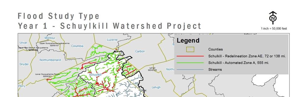

20 Year 1 Schuylkill Flood Risk Project 20
21 21
Bucks County, PA Flood Risk Review Meeting. November 2014
 Bucks County, PA Flood Risk Review Meeting November 2014 Agenda for Today Risk MAP Program overview Overview of non-regulatory Flood Risk Products and datasets Discuss mitigation action Technical overview
Flood Risk Review and Resilience Meeting: Allegheny County
 Flood Risk Review and Resilience Meeting: Allegheny County Allegheny County Conservation District Building December 5-6, 2012 Introductions Risk MAP Project Team Local partners and officials State partners
Discovery Meeting: Middle Potomac- Catoctin Watershed. FEMA REGION III September 26, 2012 Rockville, MD and Fairfax, VA
 Discovery Meeting: Middle Potomac- Catoctin Watershed FEMA REGION III September 26, 2012 Rockville, MD and Fairfax, VA Agenda Introductions Purpose of This Meeting Discovery Process Community Rating System
ASFPM Partnerships for Statewide Mitigation Actions. Alicia Williams GIS and HMP Section Manager, Amec Foster Wheeler June 2016
 ASFPM Partnerships for Statewide Mitigation Actions Alicia Williams GIS and HMP Section Manager, Amec Foster Wheeler June 2016 Summary The Concept Leveraging Existing Data and Partnerships to reduce risk
Flood Risk Review (FRR) Meeting. Cumberland County, Pennsylvania Carlisle, Pennsylvania December 5, 2016
 Meeting. Cumberland County, Pennsylvania Carlisle, Pennsylvania December 5, 2016") Flood Risk Review (FRR) Meeting Cumberland County, Pennsylvania Carlisle, Pennsylvania December 5, 2016 Why are we here today? The Flood Insurance Study (FIS) report and Flood Insurance Rate Maps (FIRMs)
Flood Risk Review (FRR) Meeting Cumberland County, Pennsylvania Carlisle, Pennsylvania December 5, 2016 Why are we here today? The Flood Insurance Study (FIS) report and Flood Insurance Rate Maps (FIRMs)
Use of FEMA Non regulatory Flood Risk Products in Planning
 Use of FEMA Non regulatory Flood Risk Products in Planning Georgia Association of Floodplain Managers Annual Conference March 24, 2016 What are the Non regulatory Flood Risk products? Go beyond the basic
Non Regulatory Risk MAP Products Flood Depth and Probability Grids
 Non Regulatory Risk MAP Products Flood Depth and Probability Grids Virginia Floodplain Management Association 2015 Floodplain Management Workshop October 29th, 2015 Nabil Ghalayini, P.E., PMP, D.WRE, CFM
Michael Taylor, PE, CFM Project Manager, AECOM August 25, 2015
 Promoting FEMA s Flood Risk Products in the Lower Levisa Watershed Michael Taylor, PE, CFM Project Manager, AECOM August 25, 2015 Agenda Study Background Flood Risk Product Overview AOMI and Mitigation
Using GISWeb to Determine Your Property s Flood Zone
 Using GISWeb to Determine Your Property s Flood Zone 1. In a new browser window, go to http://www.co.santacruz.ca.us/departments/geographicinformationsystemsgis.aspx 2. Click on GISWeb - GIS Mapping Application
Hazard Mitigation Grants. Technical Assistance Session Middlesex County, NJ December 7, 2011
 Hazard Mitigation Grants Technical Assistance Session Middlesex County, NJ December 7, 2011 Outline Purpose of Hazard Mitigation Hazard Mitigation Projects Hazard Mitigation Assistance Grant Programs Using
AMENDMENTS TO CHAPTER 50: FLOODPLAIN DEVELOPMENT
 AMENDMENTS TO CHAPTER 50: FLOODPLAIN DEVELOPMENT PART I: 2018 FLOOD MAP IMPLEMENTATION PART II: STRATEGIES TO IMPROVE THE CITY S COMMUNITY RATING SYSTEM SCORE NATIONAL FLOOD INSURANCE PROGRAM (NFIP) CREATED
New Tools for Mitigation & Outreach. Louie Greenwell Stantec
 New Tools for Mitigation & Outreach Louie Greenwell Stantec Our Discussion Today Background What is Risk MAP? FEMA Products Overview of RiskMAP Data Sets Changes Since Last FIRM Depth and Analysis Grids
10/5/2015. What Makes a Sound Floodplain Management Program? What are the Flood Problems in your Community?
 The Community Rating System (CRS) and Hazard Mitigation Planning Preparing Your Community Through Common Program Goals September 3, 2015 What Makes a Sound Floodplain Management Program? Know your community
Georgia Flood M.A.P. Program Risk MAP Plenary Session GAFM 2011
 Georgia Flood M.A.P. Program Risk MAP Plenary Session GAFM 2011 Collis Brown, Georgia DNR March 24, 2011 GA Flood Map Modernization Responsible for end-to-end production Developed aggressive outreach program
Durham County Preliminary Flood Hazard Data Public Meeting. July 28, 2016
 Durham County Preliminary Flood Hazard Data Public Meeting July 28, 2016 Why Are We Here New flood hazard data has been released as Preliminary for Durham County Statutory Due Process for review/comments
Kentucky Risk MAP It s not Map Mod II
 Kentucky Risk MAP It s not Map Mod II Risk Mapping Assessment and Planning Carey Johnson Kentucky Division of Water carey.johnson@ky.gov What is Risk MAP? Risk Mapping, Assessment, and Planning (Risk MAP)
Using Non-Regulatory RiskMAP Products in Floodplain Management. Ferrin Affleck, PE, CFM, Water Resources Engineer Project Manager Atkins
 Using Non-Regulatory RiskMAP Products in Floodplain Management Ferrin Affleck, PE, CFM, Water Resources Engineer Project Manager Atkins 1 Goal of this Presentation Inform Peak interest Stimulate creativity
Discovery Meeting: Lake Ontario. FEMA REGION II November 12-14, 2013 and November 19-21, 2013 Lake Ontario Contributing Watersheds
 Discovery Meeting: Lake Ontario FEMA REGION II November 12-14, 2013 and November 19-21, 2013 Lake Ontario Contributing Watersheds Introductions and Who s Here Project Team FEMA Region II Dewberry New York
FEMA FLOOD MAPS Public Works Department Stormwater Management Division March 6, 2018
 FEMA FLOOD MAPS Public Works Department Stormwater Management Division March 6, 2018 Presentation Overview FEMA National Flood Insurance Program (NFIP) FEMA Community Rating System (CRS) Flood Insurance
Cumberland County, NJ. Risk MAP Project Status Update April 22, 2013
 Cumberland County, NJ Risk MAP Project Status Update April 22, 2013 Agenda Project Team Milestones Risk MAP Overview Study Scope overview Regulatory products Non-regulatory products Proposed Schedule Risk
Delaware Bay / River Coastal Flood Risk Study. FEMA REGION II and III September 19, 2012
 Delaware Bay / River Coastal Flood Risk Study FEMA REGION II and III September 19, 2012 Agenda Risk MAP Program Overview Risk MAP Non-Regulatory Products & Datasets Region II New Jersey Coastal Flood Study
Kevin Wagner Maryland Department of the Environment
 Kevin Wagner Maryland Department of the Environment Topics Overview of the National Flood Insurance Program (NFIP) Mapping Regulations Insurance Mitigation Community Rating System (CRS) Questions Know
EO 11988, & The Federal Flood Risk Management Standard. FMA September 9, 2015
 EO 11988, 13690 & The Federal Flood Risk Management Standard FMA September 9, 2015 Executive Order (EO) 11988 Issued May 24,1977 Requires federal agencies to avoid long term and short term impacts associated
Community Rating System. National Flood Insurance Program
 National Flood Insurance Program Community Rating System A Local Official s Guide to Saving Lives Preventing Property Damage Reducing the Cost of Flood Insurance FEMA B-573 / May 2015 How the Community
Now You re Cooking! Recipes for Resilience. Jerri Daniels, Dewberry Diane Howe, FEMA Region 6
 Now You re Cooking! Recipes for Resilience Jerri Daniels, Dewberry jdaniels@dewberry.com Diane Howe, FEMA Region 6 diane.howe@fema.dhs.gov I ve lived here all my life 2 Who loves to cook? 3 Ingredients
Georgia Flood M.A.P. Program
 Georgia Flood M.A.P. Program Georgia Flood M.A.P. Program The Upper Chattahoochee River Basin Risk MAP Project Transitioning State Program to align with FEMA s Risk MAP Program Increase focus on risk assessment
Disaster Insurance: Are States and Insurance Companies Prepared?
 Disaster Insurance: Are States and Insurance Companies Prepared? National Conference of State Legislatures 2015 Legislative Summit Roy Wright Deputy Associate Administrator for Insurance and Mitigation
CITY OF PLANTATION ENGINEERING DEPARTMENT INTEROFFICE MEMORANDUM NO
 CITY OF PLANTATION ENGINEERING DEPARTMENT INTEROFFICE MEMORANDUM NO. 2013-003 DATE: October 22, 2012 TO: Mayor and Members of City Council FROM: Brett W. Butler, PE, CFM City Engineer SUBJECT: CRS Program
Erie County Flood Risk Review Meeting. January 18, 2018
 Erie County Flood Risk Review Meeting January 18, 2018 Agenda The value of updated flood maps for your community Review updated flood-risk data and important next steps in the Risk MAP process Increasing
Flood Risk Products. New Techniques for Identifying and Communicating Flood Risk
 Flood Risk Products New Techniques for Identifying and Communicating Flood Risk Mark Zito, GISP, CFM GIS Specialist Amol Daxikar, GISP, CFM Project Manager March 28, 2012 1% Flood with 3 Feet Sea Level
Flood Hazard Risk Mapping:
 Mitigation Division Flood Hazard Risk Mapping: Past, Present and Future Oklahoma Floodplain Management Association Ron Wanhanen, PE FEMA Region 6 Risk Analysis Branch Overview The Past The Present Risk
Chapter 7 Appendix B: National Flood Insurance Program Summary for Kaua'i County, 2015 Update
 Chapter 7 Appendix B: National Flood Insurance Program Summary for Kaua'i County, 2015 Update Topic Considerations Description INSURANCE SUMMARY STAFF RESOURCES How many NFIP policies are in Kaua i County?
Mapping Flood Risk in the Upper Fox River Basin:
 Mapping Flood Risk in the Upper Fox River Basin: Vulnerable Populations and Adverse Health Effects Presented by: Angelina Hanson STUDY AREA: Wisconsin's Upper Fox River Basin Total Population 139,309.
Floodplain Management 101. Mississippi Emergency Management Agency Floodplain Management Bureau
 Floodplain Management 101 Mississippi Emergency Management Agency Floodplain Management Bureau Stafford Act The Stafford Disaster Relief and Emergency Assistance Act (Stafford Act) (Public Law 100-707)
Chemung HUC-8 Watershed Project. February 1, 2011
 Chemung HUC-8 Watershed Project Kickoff Bi Fl t NY Big Flats, NY February 1, 2011 Introductions FEMA Region II Alan Springett, Senior Engineer, FEMA Risk Analysis Risk Assessment Lead Robert Schaefer,
NFIP Program Basics. KAMM Regional Training
 NFIP Program Basics KAMM Regional Training Floodplain 101 Homeowners insurance does not cover flood damage Approximately 25,000 flood insurance policies in KY According to BW12 analysis, approximately
Flood Risk Assessment in the
 Georgia Flood M.A.P. Program Flood Risk Assessment in the Upper Chattahoochee h h River Basin GAFM Annual Conference March 28, 2012 Agenda Map Mod to Risk MAP (Georgia Flood M.A.P.) transition Flood Risk
National Capitol Region HAZUS User Group Call
 Listen to the recording here to follow along with the presentation: http://www.freeconferencecalling.com/recordings/recording.aspx?fileid=l AF3494_04252013070630062_1154707&bridge=697620&email=&account
History of Floodplain Management in Ascension Parish
 History of Floodplain Management in Ascension Parish presented by: Kara Moree Floodplain Coordinator February 6, 2012 Floodplain 101 Floodplain 101 Base or 1% Flood: A flood having a 1% chance of being
Community Resilience & NFIP s Community Rating system
 Community Resilience & NFIP s Community Rating system Ajita Atreya Wharton Risk Management and Decision Processes Center University of Pennsylvania National Association of Counties (NACo) Session on Risk
The New Maryland Model Floodplain Management Ordinance
 Department of the Environment The New Maryland Model Floodplain Management Ordinance MAFSM Conference October 21, 2010 Kevin G. Wagner Agenda Brief history/background What s driving new ordinances Introduction
Best Practices. for Incorporating Building Science Guidance into Community Risk MAP Implementation November 2012
 Best Practices for Incorporating Building Science Guidance into Community Risk MAP Implementation November 2012 Federal Emergency Management Agency Department of Homeland Security 500 C Street, SW Washington,
Facts & Info regarding the NFIP in Mathews County VA And the Mathews County Floodplain Management Ordinance
 Facts & Info regarding the NFIP in Mathews County VA And the Mathews County Floodplain Management Ordinance As of 05-31-2014: Current NFIP policies in Mathews County = 1687 NFIP Claims= 1127, for a total
FREQUENTLY ASKED QUESTION ABOUT FLOODPLAINS Michigan Department of Environmental Quality
 FREQUENTLY ASKED QUESTION ABOUT FLOODPLAINS Michigan Department of Environmental Quality WHAT IS A FLOOD? The National Flood Insurance Program defines a flood as a general and temporary condition of partial
Justification for Floodplain Regulatory Standards in Illinois
 Justification for Floodplain Regulatory Standards in Illinois Office of Water Resources Issue Paper April, 2015 Proactive Illinois floodplain and floodway regulatory standards have prevented billions of
Preliminary DFIRM Community Coordination (PDCC) Meeting Gilchrist & Levy Counties, FL. April 30, 2015
 Meeting Gilchrist & Levy Counties, FL. April 30, 2015") Preliminary DFIRM Community Coordination (PDCC) Meeting Gilchrist & Levy Counties, FL April 30, 2015 Agenda 1. Introductions 2. Study Process and Timeline 3. Overview of Preliminary Products 4. Overview
Preliminary DFIRM Community Coordination (PDCC) Meeting Gilchrist & Levy Counties, FL April 30, 2015 Agenda 1. Introductions 2. Study Process and Timeline 3. Overview of Preliminary Products 4. Overview
Action Items for Flood Risk Management on Wildcat Creek Interagency success with floodplain management plans and flood forecast inundation maps
 Presentation to USACE 2012 Flood Risk Management and Silver Jackets Joint Workshop, Harrisburg, Pennsylvania Action Items for Flood Risk Management on Wildcat Creek Interagency success with floodplain
Floodplain Management. City Council Work Session April 16, 2013
 Floodplain Management City Council Work Session April 16, 2013 1 Discussion Agenda Flood Insurance Rate Changes Community Rating System Recommendation Floodplain Ordinance Enhancements Modifications Public
Lake Erie. June 10 & 11, 2014
 Discovery Meeting: Lake Erie FEMA REGION II June 10 & 11, 2014 Lake Erie Contributing Watersheds eds Introductions and Who s Here Project Team FEMA Region II RAMPP Local Stakeholders Invited Local Community
Requirements for Mapping Levees Complying with Section of the NFIP Regulations
 FACT SHEET Requirements for Mapping Levees Complying with Section 65.10 of the NFIP Regulations As part of a mapping project, it is the levee owner s or community s responsibility to provide data and documentation
Increasing Risk Communication for Property Owners with Risk NJAFM Conference Atlantic City, NJ
 RISK COMMUNICATION Increasing Risk Communication for Property Owners with Risk MAP Products Garrett Skinner CFM Garrett Skinner, CFM 2014 NJAFM Conference Atlantic City, NJ Overview Background Flood Risk
Findings/Debrief Meeting September 9, CDOT R4 Headquarters Big Thompson Conference Room W 10 th St. Greeley, CO 80634
 Findings/Debrief Meeting September 9, 2016 CDOT R4 Headquarters Big Thompson Conference Room 10601 W 10 th St. Greeley, CO 80634 Discovery Review & Outcome May 25 Discovery Meeting Summary Summarize Data
LOCAL OFFICIALS MEETING Lake Wausau Physical Map Revision MARATHON COUNTY, WISCONSIN FEBRUARY 9, 2017
 LOCAL OFFICIALS MEETING Lake Wausau Physical Map Revision MARATHON COUNTY, WISCONSIN FEBRUARY 9, 2017 Welcome & Introduction Michelle Staff Floodplain Management Policy Coordinator, WDNR Michelle.Staff@Wisconsin.gov
Flood Insurance Reform Act of 2012
 Flood Insurance Reform Act of 2012 Impact of changes to the NFIP Note: This Fact Sheet deals specifically with Sections 205 and 207 of the Act. In 2012, the U.S. Congress passed the Flood Insurance Reform
Repetitive Loss Area Revisit # 6 Walter Road Area Jefferson Parish
 Repetitive Loss Area Revisit # 6 Walter Road Area Jefferson Parish www.floodhelp.uno.edu Supported by FEMA Acknowledgement The compilation if this report was managed by Erin Patton, CFM, a UNO-CHART Research
Federal Flood Risk Management Standards. An Update on Federal Flood Resilience Standards
 Federal Flood Risk Management Standards An Update on Federal Flood Resilience Standards Purpose of Today s Briefing Facilitate the understanding of Executive Order (E.O.)13690 and its implementation Discuss
Discovery Report. Cache River Watershed, Alexander, Johnson, Pulaski, and Union Counties, Illinois
 Discovery Report Cache River Watershed, 07140108 Alexander, Johnson, Pulaski, and Union Counties, Illinois 12/21/2012 i Project Area Community List Community Name Alexander County Village of Tamms Johnson
MUNICIPAL LAND USE STRATEGIES for Improving Flood Resilience
 MUNICIPAL LAND USE STRATEGIES for Improving Flood Resilience Strategy for a Flood Resistant Southern Tier Central Region (LWRP project) This presentation was prepared by Southern Tier Central Regional
Upper Joachim Creek Public Survey on Potential Flood Risk Reduction
 Upper Joachim Creek Public Survey on Potential Flood Risk Reduction This survey is intended to help the interagency planning committee to receive public feedback on specific flood risk reduction techniques,
Modernization, FEMA is Recognizing the connection between damage reduction and
 EXECUTIVE SUMMARY Every year, devastating floods impact the Nation by taking lives and damaging homes, businesses, public infrastructure, and other property. This damage could be reduced significantly
Crediting Adaptation Strategies through the National Flood Insurance Program s Community Rating System Coordinator s Manual
 Crediting Adaptation Strategies through the National Flood Insurance Program s Community Rating System Coordinator s Manual W. Thomas Hawkins, Adjunct Faculty, University of Florida, Levin College of Law
9.10 HEIDELBERG TOWNSHIP
 9.10 HEIDELBERG TOWNSHIP This section presents the jurisdictional annex for Heidelberg Township. A. HAZARD MITIGATION PLAN POINT OF CONTACT Name Title/ Department Address Telephone Fax Email Primary Point
City of St. Augustine. Floodplain Management Higher Standards Information
 City of St. Augustine Floodplain Management Higher Standards Information There are different regulations that communities can use to help protect existing and future development and natural floodplain
Role of Disaster Insurance in Improving Resilience: An Expert Meeting The Resilient America Roundtable
 Role of Disaster Insurance in Improving Resilience: An Expert Meeting The Resilient America Roundtable National Academy of Science Washington, DC July 9, 2015 Roseville Demographics Primary population
*How Federal Policy. Causes Flood Disasters. Leslie A. Bond, CFM LA Bond Associates
 *How Federal Policy Causes Flood Disasters Leslie A. Bond, CFM LA Bond Associates *The high cost of flood disasters *We do not know what floods cost. *Published estimates do not include all costs of disasters.
SECTION 9: MAPS AND DATA
 SECTION 9: MAPS AND DATA Contents 9.1. NFIP Maps and Data... 9-2 9.1.1. Adopting and enforcing NFIP floodplain maps and data... 9-2 9.1.2. Adopting and enforcing more restrictive data... 9-2 9.1.3. Annexations...
AGENDA. Floodplain Manager s Toolkit Unlocking the Hidden Potential of Floodplain Data for Your Community
 Floodplain Manager s Toolkit Unlocking the Hidden Potential of Floodplain Data for Your Community TFMA Spring Conference May 29, 2014 Jessica D. Baker, PE, CFM, PMP Samuel Amoako-Atta, GISP, CFM Eric Hajek,
California Building Code and the NFIP. John Ingargiola, Senior Engineer FEMA Building Science Branch
 California Building Code and the NFIP John Ingargiola, Senior Engineer FEMA Building Science Branch CA Major Disaster Declarations and Federal Assistance $21 $21 $76 $78 7 declarations, 2004-2016, total
Door County Floodplain Program Informational Meeting
 Door County Floodplain Program Informational Meeting Door County Land Use Services Department Wisconsin Department of Natural Resources January 15, 2018 Floodplain = Land affected by flood event with a
Are Risk MAP Products Really on Our Mind?
 Are Risk MAP Products Really on Our Mind? ASFPM 2015 Atlanta, GA Presented By: Jason Wilson, PE, CFM William Fain, EIT, CFM Amec Foster Wheeler Presentation Overview 1. What is Risk MAP/What are Risk Map
Flood Risk Resilience in Alabama: Challenges and Successes
 Flood Risk Resilience in Alabama: Challenges and Successes Leslie A. Durham, P.E. Floodplain Management Branch Chief Alabama Office of Water Resources 10 Year Partnership with FEMA Flood Map Modernization
Community Coordination Meeting Sagadahoc County, Maine
 Community Coordination Meeting Sagadahoc County, Maine Risk MAP Study April 2, 2014 Agenda Welcome and Introductions Project Timeline Flood Hazard Analysis Recap Flood Risk Products Action: Hazard Mitigation
REAL ESTATE FLOOD DISCLOSURE PROGRAM & FLOOD MAP INFORMATION SERVICES
 REAL ESTATE FLOOD DISCLOSURE PROGRAM & FLOOD MAP INFORMATION SERVICES Lisa Foster, CFM, Floodplain Coordinator ldfoster@pinellascounty.org January 26, 2018 Why are you here? Save your clients money on
Outreach Georgia Flood M.A.P. Program. GAFM Technical Conference Flood Risk Outreach and Policy Session
 Outreach Georgia Flood M.A.P. Program GAFM Technical Conference Flood Risk Outreach and Policy Session 7 th Annual Technical Conference, Lanier Islands March 29, 2012 Risk Communication Key Learnings People
Why do we care about floodplains?
 NFIP 101 Outline What is the NFIP? What are its goals? What is a flood? A floodplain? Maps, FIRMs, and FISs NFIP Requirements Local Flood Ordinances & Permitting Tips, Tricks, & Tools Mitigation & Other
Leveraging HAZUS for Risk Assessment Analysis within Risk MAP
 Leveraging HAZUS for Risk Assessment Analysis within Risk MAP Jen Meyer - FEMA Region X Shane Parson - RAMPP PTS Team (URS Corp.) 2010 HAZUS Conference - August 2010 The Paradigm Shift: Map Mod to Risk
FLOOD ZONE DETERMINATION REPORT
 Western Technologies Group FLOOD ZONE DETERMINATION REPORT Flood Determination WTG provides Flood accurate, Zone Determination high-quality, Reports insured provide Flood high Determinations. quality,
Sources of FEMA Funding
 ASFPM Nonstructural/Floodproofing Workshops Sources of FEMA Funding ASFPM Nonstructural/Floodproofing Committee Gene Barr, CFM Principal Project Manager Nonstructural Specialist Sources of FEMA Funding
Urban Flooding in Illinois The Changing Face of Floods
 Urban Flooding in Illinois The Changing Face of Floods Chicago Albany Park Neighborhood June 2008 National Academies of Science Chicago, IL September 19, 2017 Welcome to Illinois Floods? Really? Illinois
National Flood Insurance Program (NFIP) Community Rating System (CRS) Together North Jersey Resilient Task Force Meeting
 Community Rating System (CRS) Together North Jersey Resilient Task Force Meeting") National Flood Insurance Program (NFIP) Community Rating System (CRS) Together North Jersey Resilient Task Force Meeting April 3, 2017 Marianne Luhrs, AICP FEMA R2 CRS Coordinator Visual Intro-1 CRS Program
National Flood Insurance Program (NFIP) Community Rating System (CRS) Together North Jersey Resilient Task Force Meeting April 3, 2017 Marianne Luhrs, AICP FEMA R2 CRS Coordinator Visual Intro-1 CRS Program
Changes Coming to the National Flood Insurance Program What to Expect. Impact of changes to the NFIP under Section 205 of the Biggert-Waters Act
 Changes Coming to the National Flood Insurance Program What to Expect Impact of changes to the NFIP under Section 205 of the Biggert-Waters Act Flood Risk Flood risks and the costs of flooding Weather
Levees: PL84-99 and the NFIP
 Levees: PL84-99 and the NFIP Tony D. Krause, P.E., CFM Flood Risk and Floodplain Management Omaha District US Army Corps of Engineers Objectives and Overview Objectives: Identify overlaps between Federal
REAL ESTATE FLOOD DISCLOSURE PROGRAM & FLOOD MAP INFORMATION SERVICES
 REAL ESTATE FLOOD DISCLOSURE PROGRAM & FLOOD MAP INFORMATION SERVICES Lisa Foster, CFM, Floodplain Coordinator ldfoster@pinellascounty.org January 26, 2018 Why are you here? Save your clients money on
Vision to Action: Creating and Using a Flood Risk Assessment for Identifying Mitigation Options
 Vision to Action: Creating and Using a Flood Risk Assessment for Identifying Mitigation Options Lisa Graff, CFM, GISP Clayton Ballerine, CFM Brad McVay, CFM, GISP University of Illinois Prairie Research
What are the savings? An Assessment of the National Flood Insurance Program s (NFIP) Community Rating System (CRS)
 Community Rating System (CRS)") What are the savings? An Assessment of the National Flood Insurance Program s (NFIP) Community Rating System (CRS) Ajita Atreya Postdoctoral Research Fellow Wharton Risk Management and Decision Processes
What are the savings? An Assessment of the National Flood Insurance Program s (NFIP) Community Rating System (CRS) Ajita Atreya Postdoctoral Research Fellow Wharton Risk Management and Decision Processes
Key Fundamentals of Flood Insurance in the NFIP!
 a Welcome to Key Fundamentals of Flood Insurance in the NFIP! A Before and After approach for Housing Counselors Presented by: 1 Before the Flood Presenter Melanie Graham After the Flood Presenter Erin
Presented by: Connie Perkins, PE, CFM April 20, 2016
 Presented by: Connie Perkins, PE, CFM April 20, 2016 City of Sacramento s Flood History Need for a Comprehensive Flood Management Plan (CFMP) Overview of Sacramento s CFMP 2016 Next Steps Sacramento
DuPage County East Branch DuPage River Resiliency Project. Benefit Cost Analysis
 DuPage County East Branch DuPage River Resiliency Project Benefit Cost Analysis 1.0 Benefit Cost Analysis Preparation The BCA for this proposal was a collaborative effort between DuPage County, V3 engineering
National Flood Insurance Program, Biggert-Waters 2012, and Homeowners Flood Insurance Affordability Act 2014
 National Flood Insurance Program, Biggert-Waters 2012, and Homeowners Flood Insurance Affordability Act 2014 Janice Mitchell, Insurance Specialist Floodplain Management and Insurance Branch FEMA Region
ASFPM Update and NFIP Reform. KAMM 10 th Anniversary Conference September 9, 2014
 ASFPM Update and NFIP Reform KAMM 10 th Anniversary Conference September 9, 2014 AND HE SAID Floods are 'acts of God,' but flood losses are largely acts of man. 1945 PhD Dissertation Human Adjustments
Planning Process---Requirement 201.6(b): An open public involvement process is essential to the development of an effective plan.
: An open public involvement process is essential to the development of an effective plan.") Section 3 Capability Identification Requirements Planning Process---Requirement 201.6(b): An open public involvement process is essential to the development of an effective plan. Documentation of the Planning
Section 3 Capability Identification Requirements Planning Process---Requirement 201.6(b): An open public involvement process is essential to the development of an effective plan. Documentation of the Planning
USACE Levee Safety Meeting FEMA Overview
 USACE Levee Safety Meeting FEMA Overview Christine Gaynes, CFM FEMA Region V Roger Denick, PE, CFM FEMA Region V Service Center Agenda FEMA Region V Overview FEMA Levee Program Levee Guidance Transformation
Floodplain Manager s Toolkit Unlocking the Hidden Potential of Floodplain Data for Your Community
 Floodplain Manager s Toolkit Unlocking the Hidden Potential of Floodplain Data for Your Community TFMA South Central Lunch Event San Antonio, TX June 12, 2014 Jessica D. Baker, PE, CFM, PMP Samuel Amoako-Atta,
National Flood Insurance Program and Biggert-Waters 2012
 National Flood Insurance Program and Biggert-Waters 2012 National Flood Insurance Program NFIP was created by Congress in 1968 Coverage underwritten by the Federal Government, administered by FEMA NFIP
COLLIER COUNTY FLOODPLAIN MANAGEMENT
 COLLIER COUNTY FLOODPLAIN MANAGEMENT FREQUENTLY ASKED QUESTIONS The following information is based on common questions from the public. If you have a specific question or need further information, please
Cameron County, TX. Consultation Coordination Officer (CCO) Meeting. Please sign in (sheet at front of the room) Meeting will begin at 9:00
 Meeting. Please sign in (sheet at front of the room) Meeting will begin at 9:00") Cameron County, TX Consultation Coordination Officer (CCO) Meeting Please sign in (sheet at front of the room) Meeting will begin at 9:00 July 29, 2015 Lisa Jennings FEMA Region 6 Roles & Responsibilities
Cameron County, TX Consultation Coordination Officer (CCO) Meeting Please sign in (sheet at front of the room) Meeting will begin at 9:00 July 29, 2015 Lisa Jennings FEMA Region 6 Roles & Responsibilities
Article 23-6 FLOODPLAIN DISTRICT
 AMENDING THE CODE OF THE CITY OF PITTSFIELD CHAPTER 23, ZONING ORDINANCE SECTION I That the Code of the City of Pittsfield, Chapter 23, Article 23-6 Floodplain District, shall be replaced with the following:
Community Coordination Meeting. York County, Maine. Risk MAP Study
 Community Coordination Meeting York County, Maine Risk MAP Study January 9, 2014 Agenda Welcome and Introductions Project Timeline Flood Hazard Analysis Recap (Digital Conversion, Riverine and Coastal)
9.24 WEISENBERG TOWNSHIP
 9.24 WEISENBERG TOWNSHIP This section presents the jurisdictional annex for Weisenberg Township. A. HAZARD MITIGATION PLAN POINT OF CONTACT Name Title/ Department Address Telephone Fax Email Primary Point
a) Ensure public safety through reducing the threats to life and personal injury.
 Ensure public safety through reducing the threats to life and personal injury.") SECTION VII: FLOODPLAIN DISTRICT 7-1 Statement Of Purpose The purposes of the Floodplain District are to: a) Ensure public safety through reducing the threats to life and personal injury. b) Eliminate
SECTION VII: FLOODPLAIN DISTRICT 7-1 Statement Of Purpose The purposes of the Floodplain District are to: a) Ensure public safety through reducing the threats to life and personal injury. b) Eliminate