The New Maryland Model Floodplain Management Ordinance
|
|
|
- Wesley Lucas
- 5 years ago
- Views:
Transcription
1 Department of the Environment The New Maryland Model Floodplain Management Ordinance MAFSM Conference October 21, 2010 Kevin G. Wagner
2 Agenda Brief history/background What s driving new ordinances Introduction to new model ordinance Customizing the model ordinance Ordinance review checklist
3 Brief History of FPM in Maryland 1860 First recorded flood in MD 1933 State waterway construction authority 1968 NFIP authorized by Congress 1972 Tropical Storm Agnes, DNR/WRA designated State Coordinator 1973 Flood Disaster Protection Act (Fed/State) 1976 Flood Hazard Mgmt. Act (MD)
4 Brief History of FPM in Maryland 1983 WYO program began 1991 first State model ordinance completed (revisions in 1995, 1999, 2004 and 2010) 1994 National Flood Insurance Reform Act 1995 MDE designated State Coordinator Present
5 Types of Flooding in MD Nontidal (riverine) Tidal Coastal (wave action)
6 Floodplains FEMA differentiates two main types: riverine & coastal Maryland differentiates tidal & nontidal floodplain for regulatory purposes FEMA maps/studies used as a minimum Standard is 100-year, or 1% annual chance flood

7 National Flood Insurance Program (NFIP) Created in 1968 Administered by FEMA Three main parts Numerous stakeholders Community = Participating County or Municipality
8 Joining the NFIP Land Use Authority 1. Application FEMA Form Resolution of Intent 3. Floodplain Management Ordinance No SFHA? (Resolution for Nonfloodprone community) Resolution of Delegation?
9 Three Main Parts of the NFIP Floodplain Management/ Regulations Insurance Mapping
10 NFIP Basics 1. Mapping Flood Insurance Rate Map (FIRM)/Flood Insurance Study (FIS) 2. Floodplain Management/Regulations Local Floodplain Management Ordinance 3. Insurance Renters, Homeowners, Business Owners
11 NFIP: Mapping What flood risks have been mapped in your community? Zone A, AE, V or X (shaded or unshaded) and floodway? Local floodplain management ordinance based on the map
12 NFIP: Regulations Based on Code of Federal Regulations (44 CFR 60.3) Local Floodplain Management Ordinance Based on flood risk zones mapped in community Higher regulatory standards?
13 NFIP: Insurance Foundation of program Makes flood insurance available to renters, and home and business owners What is the insurance ramification? Policies written by Write Your Own (WYO) companies NFIP website:
14 Floodsmart
15 Three Main Parts of the NFIP Mapping Regulations Insurance
16 NFIP Community Most important part of the NFIP! County or incorporated municipality Local Floodplain Manager/Code Official Adopt and enforce a local floodplain management ordinance Based on maps (44 CFR 60.3) Higher regulatory standards? (ex. Freeboard)
17 Communities in the NFIP 135 participating communities Ocean City first community to join the NFIP (July 1970) Most policies in State, ranked 29 th in nation Prince George s County is a Class 5 CRS community
18 Who Else is Involved? Property Owners/Renters Surveyors/Engineers/Architects Land Developers Contractors Excavation/foundation, Plumbing, HVAC, Electrical, Propane/Oil Mortgage Lenders
19 Who Else is Involved? Flood determination companies Insurance companies and agents Local officials (Floodplain Manager, Code Enforcement Officer, Planner, etc.) Other State/Federal Agencies Real estate professionals Emergency response community
20 MDE s Role NFIP State Coordinating Office Provide technical assistance on the NFIP Ordinance assistance Work with various stakeholders including local community Map Mod Coordination for 17 Counties Wetlands and waterways permitting
21 Map Revisions Drive Ordinance Reviews and Adoptions Types of changes to FIRMs Zones, new elevation datum, etc. Timeline for ordinance adoption Letter of Final Determination (LFD) triggers six-month clock Consequences
22 Results of Review of 1992 Model Ordinance Inadequate in many respects Regulatory language Missing Federal regulations Not being revised Ordinances based on 1992 model are not consistent with current regulations
23 Introduction to New Model Many hours invested! Eliminates unenforceable language Reviewed by local FPMs throughout the State Incorporated feedback (ex. freeboard, compensatory storage) Reviewed by FEMA Region III
24 Introduction to New Model Model Ordinance Full, nontidal or tidal Resource Version Annotated with CFR, COMAR, Building Code/MBPS, CRS Notes Explains certain provisions; identifies higher standards
25 Introduction to New Model Flow charts Help with implementation Consistent with State regulations for nontidal waters of the State Retains certain long-standing recommendations
26 Retains Long-Standing Recommendations Freeboard (1 foot) Flood protection setbacks MDE review of variance requests Subdivision size triggering flood study 5 lots or 5 acres, whichever is lesser Panelboards 3 ft above BFE
27 Retains Long-Standing Recommendations Manufactured homes placed or sub. improved in existing man. home park must be elevated. No allowance to elevate 36 above grade (See 44 CFR 60.3(c)(12)(ii)).
28 Which Model to Use? Full Ordinance Has the kitchen sink Nontidal Ordinance Excludes tidal, V Zones and Coastal A Zones (CAZ) Tidal Ordinance Same as nontidal, but includes tidal
29 Full Ordinance 9 Sections Includes nontidal, tidal and Coastal High Hazard Areas (V Zones/CAZ)
30 Nontidal Ordinance 8 Sections Excludes tidal, V Zones and CAZ
31 Tidal Ordinance 8 Sections Nontidal provisions kept due to higher regulatory standards Flood protection setbacks State nontidal regulations Only two modifications Definition for Flood Zone (Section 2.0) Section 3.6 Review of Application

32 Tidal Version

33 Tidal Version
34 Resource Version Available for each ordinance type Annotated with CFR, COMAR, Building Code/MBPS, CRS See Note

35 Introduction to New Model Resource Version Annotated with CFR, COMAR, MBPS, CRS

36 Introduction to New Model Resource Version Annotated with CFR, COMAR, MBPS, CRS
37 Notes Explains See Note reference in Resource version Indicates where higher regulatory standards exist
38 Notes
39 Flow Charts Tidal and riverine flooding Riverine flooding only V Zone and CAZ requirements and new construction Accessory structures Manufactured homes

40 Flow Charts
41 Introduction to New Model Removes some recommendations Requirement for variance for fill in excess of 600 cy Requirement for variance for accessory structures larger than 600 sf The cumulative substantial improvement language (tracking requirement)
42 Introduction to New Model Modifies some recommendations Agreement to Submit an Elevation Certificate Combined the Declaration of Land Restriction and Nonconversion Agreement How enclosures below elevated buildings and accessory structures are handled (see table)
43 Previous Model Ordinance New Model Ordinance <300 sq ft: NCA 1 - not recorded on deed sq ft: DLR 2 recorded on deed >600 sq ft: By variance, DLR recorded on deed DLR(NCA) 3 recorded for: Enclosures below elevated buildings (parking, storage, access) Crawl/underfloor spaces more than 4 ft in height Accessory structures 300 sq ft and larger
44 New Provisions that Exceed NFIP Minimums Additional foot of freeboard (2 ft) Critical facilities Fill Compensatory storage in nontidal water
45 New Provisions that Exceed NFIP Minimums Two submissions of Elevation Certificates Accessory structure size/value V Zone Design Certificate Coastal A Zones (CAZ)/Limit of Moderate Wave Action (LiMWA)
46 Freeboard Factor of safety above Base Flood Can assist with errors during construction process (ie. Structure built too low) Lower flood insurance premiums Additional CRS credit (2 feet = 200 points)
47 Freeboard Maryland Commission on Climate Change recommended 2 foot freeboard in tidal areas (2007?)
48 Coastal A Zones V Zone standards (some exceptions) Wave heights between 1.5 to 3 feet FEMA to include in coastal studies after October 1, 2008 New coastal study nearly complete for MD Referenced in ASCE 7, ASCE 24 and 2009 ICC codes

49 Coastal A Zones

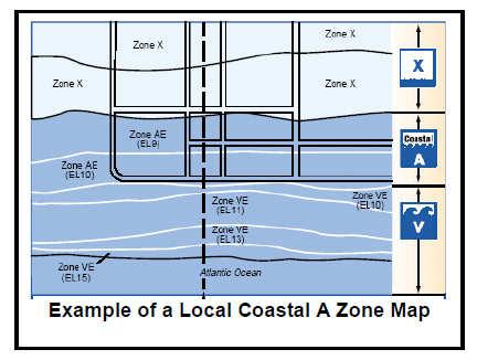
50 Coastal A Zones
51 Community Rating System Resource Version identifies CRS Activity 430 series (higher standards) 200 points for 2 foot freeboard Up to 650 points for CAZ MDE will request FEMA/ISO review to get estimate of uniform credits
52 Customize the Model Ordinance MDE will help community identify the applicable version of the model based on flood zones on new FIRMs Fill in placeholders [IN BRACKETS] MDE will provide the date of the first effective FIRM (used in several places)
53 Customize the Model Ordinance Fill in Date of FIS in Section 1.5 Provided by Letter of Final Determination (LFD) Fill in Accessory Structure size and cost limitations at Sec. 5.7 and Sec. 6.5
54 Customize the Model Ordinance Fill in Accessory Structure size and cost limitations at Sec. 5.7 and Sec. 6.5 Certain provisions that exceed NFIP/State minimums may be modified to meet the minimums (refer to the Resource Version and Notes)
55 Customize the Model Ordinance MDE assistance: Add other community-specific provisions from existing ordinance Add cumulative substantial improvement/damage or repetitive loss requirement Reference the Maryland Building Performance Code (especially Sec and R322)
56 Delegation of authority to another jurisdiction Adopt equivalent ordinance By reference? Nonfloodprone? Execute interlocal agreement (Resolution of Delegation) May need to be updated
57 Assistance from MDE Phone / Response to written inquiries Review prior to adoption to assure modifications are acceptable Watch timing FEMA has no flexibility if not adopted by FIRM effective date
58 Adoption Process Start early! After preliminary maps/study come out LFD starts 6-month countdown Develop an ordinance that works for your community Coastal communities will go through this process again
59 Ordinance Review Checklist Know your ordinance! Review preliminary maps/study closely New zones being added? What s been giving you a headache? Multiple variances, elevating utilities, etc.? Understand what you have and what you need
60 Sources of Additional Information Training at EMI Websites FEMA telephone numbers
61 Emergency Management Institute (EMI) Located in Emmitsburg, MD Numerous courses available for FREE! Floodplain Management, Retrofitting Floodprone Residential Bldgs., CRS, etc. Complete FEMA Form 75-5 and forward to MEMA State Training Officer
62 Websites FEMA Maryland Department of the Environment FEMA Map Service Center FEMA Mapping Information Platform NFIP
63 Phone Numbers FEMA Publication Warehouse FEMA Map Information exchange (FMIX) FEMA-MAP ( )
64 Maryland Department of the Environment Water Management Administration Wetlands & Waterways Program Kevin G. Wagner, CFM Washington Boulevard Baltimore, MD TTY Users:
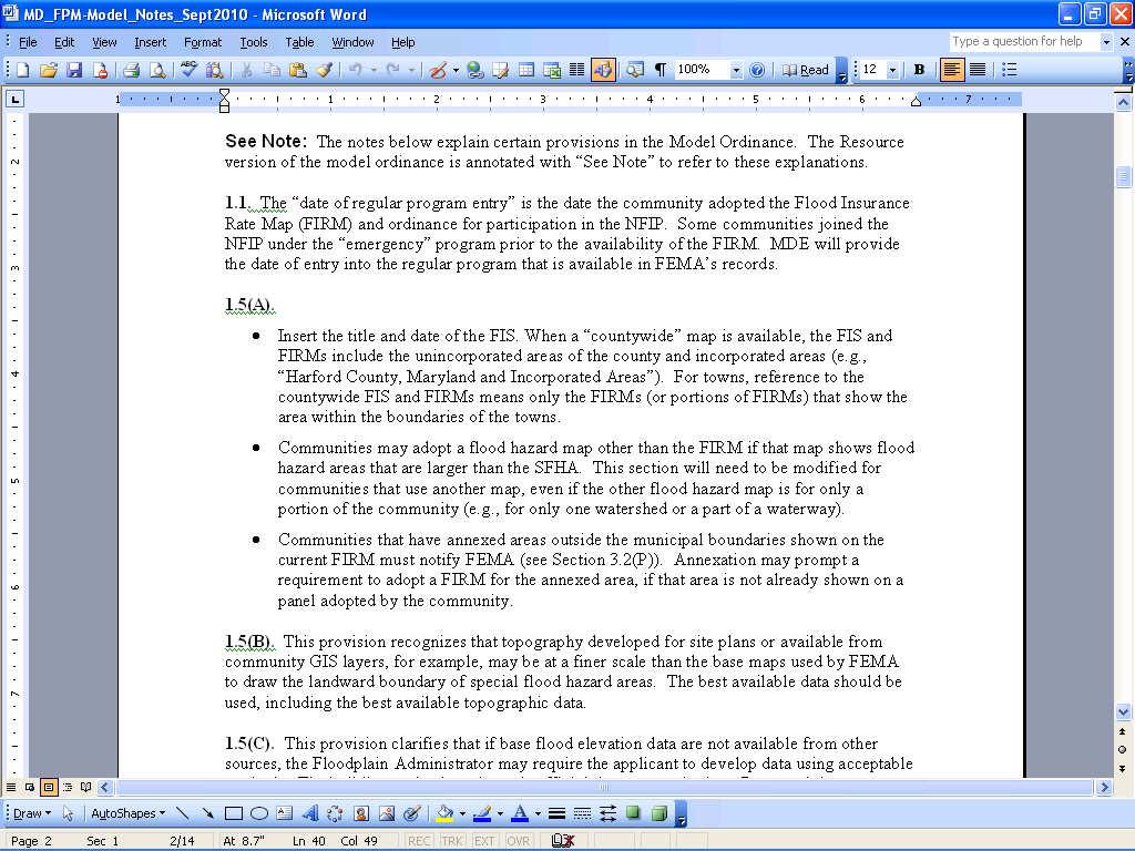
Maryland Model Floodplain Management Ordinance (May, 2014) MODEL NOTES
 MODEL NOTES") Maryland Model Floodplain Management Ordinance (May, 2014) MODEL NOTES The model floodplain management ordinance that most Maryland communities have used as the basis for their regulations since the early
Maryland Model Floodplain Management Ordinance (May, 2014) MODEL NOTES The model floodplain management ordinance that most Maryland communities have used as the basis for their regulations since the early
Kevin Wagner Maryland Department of the Environment
 Kevin Wagner Maryland Department of the Environment Topics Overview of the National Flood Insurance Program (NFIP) Mapping Regulations Insurance Mitigation Community Rating System (CRS) Questions Know
California Building Code and the NFIP. John Ingargiola, Senior Engineer FEMA Building Science Branch
 California Building Code and the NFIP John Ingargiola, Senior Engineer FEMA Building Science Branch CA Major Disaster Declarations and Federal Assistance $21 $21 $76 $78 7 declarations, 2004-2016, total
Floodplain Management 101. Mississippi Emergency Management Agency Floodplain Management Bureau
 Floodplain Management 101 Mississippi Emergency Management Agency Floodplain Management Bureau Stafford Act The Stafford Disaster Relief and Emergency Assistance Act (Stafford Act) (Public Law 100-707)
Questions about the National Flood Insurance Program
 Questions about the National Flood Insurance Program Federal Emergency Management Agency (FEMA) Questions and Answers What is the National Flood Insurance Program (NFIP)? The NFIP is a Federal program
North Carolina Department of Public Safety Emergency Management Risk Management
 North Carolina Department of Public Safety Emergency Management Risk Management Roy Cooper, Governor Erik A. Hooks, Secretary Michael A. Sprayberry, Director INSTRUCTIONS FOR COMPLETING THE NORTH CAROLINA
The National Flood Insurance Program and Flood Insurance Rate Map for San Francisco. Presentation at Treasure Island Community Meeting
 The National Flood Insurance Program and Flood Insurance Rate Map for San Francisco Presentation at Treasure Island Community Meeting October 17, 2007 1 National Flood Insurance Program (NFIP) Overview
Bucks County, PA Flood Risk Review Meeting. November 2014
 Bucks County, PA Flood Risk Review Meeting November 2014 Agenda for Today Risk MAP Program overview Overview of non-regulatory Flood Risk Products and datasets Discuss mitigation action Technical overview
AMENDMENTS TO CHAPTER 50: FLOODPLAIN DEVELOPMENT
 AMENDMENTS TO CHAPTER 50: FLOODPLAIN DEVELOPMENT PART I: 2018 FLOOD MAP IMPLEMENTATION PART II: STRATEGIES TO IMPROVE THE CITY S COMMUNITY RATING SYSTEM SCORE NATIONAL FLOOD INSURANCE PROGRAM (NFIP) CREATED
National Flood Insurance Program, Biggert-Waters 2012, and Homeowners Flood Insurance Affordability Act 2014
 National Flood Insurance Program, Biggert-Waters 2012, and Homeowners Flood Insurance Affordability Act 2014 Janice Mitchell, Insurance Specialist Floodplain Management and Insurance Branch FEMA Region
Introduction to the National Flood Insurance Program: A Guide for Coastal Property Owners MAINE BEACHES CONFERENCE 2017
 Introduction to the National Flood Insurance Program: A Guide for Coastal Property Owners MAINE BEACHES CONFERENCE 2017 SUE BAKER, CFM STATE NFIP COORDINATOR MAINE DEPT OF AGRICULTURE, CONSERVATION & FORESTRY
SECTION 9: MAPS AND DATA
 SECTION 9: MAPS AND DATA Contents 9.1. NFIP Maps and Data... 9-2 9.1.1. Adopting and enforcing NFIP floodplain maps and data... 9-2 9.1.2. Adopting and enforcing more restrictive data... 9-2 9.1.3. Annexations...
History of Floodplain Management in Ascension Parish
 History of Floodplain Management in Ascension Parish presented by: Kara Moree Floodplain Coordinator February 6, 2012 Floodplain 101 Floodplain 101 Base or 1% Flood: A flood having a 1% chance of being
Nassau County, Florida Consultation Coordination Officer (CCO) Meeting. February 24, 2016 Fernandina Beach, Florida
 Meeting. February 24, 2016 Fernandina Beach, Florida") Nassau County, Florida Consultation Coordination Officer (CCO) Meeting February 24, 2016 Fernandina Beach, Florida Agenda Introductions Coastal Study Update Study Process and Timeline Flood Insurance Implications
Nassau County, Florida Consultation Coordination Officer (CCO) Meeting February 24, 2016 Fernandina Beach, Florida Agenda Introductions Coastal Study Update Study Process and Timeline Flood Insurance Implications
National Flood Insurance Program and Biggert-Waters 2012
 National Flood Insurance Program and Biggert-Waters 2012 National Flood Insurance Program NFIP was created by Congress in 1968 Coverage underwritten by the Federal Government, administered by FEMA NFIP
Oak Island 1999 Hurricane Floyd
 Oak Island 1999 Hurricane Floyd Topics to be Discussed What is a flood zone Flood zones in Oak Island Special Flood Hazard Areas (SFHA) Flood insurance Base Flood Elevations (BFEs) Building in flood zones
Community Rating System. National Flood Insurance Program
 National Flood Insurance Program Community Rating System A Local Official s Guide to Saving Lives Preventing Property Damage Reducing the Cost of Flood Insurance FEMA B-573 / May 2015 How the Community
REAL ESTATE FLOOD DISCLOSURE PROGRAM & FLOOD MAP INFORMATION SERVICES
 REAL ESTATE FLOOD DISCLOSURE PROGRAM & FLOOD MAP INFORMATION SERVICES Lisa Foster, CFM, Floodplain Coordinator ldfoster@pinellascounty.org January 26, 2018 Why are you here? Save your clients money on
Updates to Maine Coastal Flood Insurance Rate Maps (FIRM s): What a Local Official Should Know. Presented by: Steve Johnson, P.E.
: What a Local Official Should Know. Presented by: Steve Johnson, P.E.") Updates to Maine Coastal Flood Insurance Rate Maps (FIRM s): What a Local Official Should Know Presented by: Steve Johnson, P.E. Town Engineer October 4, 2018 Introduction Federal Emergency Management
Updates to Maine Coastal Flood Insurance Rate Maps (FIRM s): What a Local Official Should Know Presented by: Steve Johnson, P.E. Town Engineer October 4, 2018 Introduction Federal Emergency Management
Facts & Info regarding the NFIP in Mathews County VA And the Mathews County Floodplain Management Ordinance
 Facts & Info regarding the NFIP in Mathews County VA And the Mathews County Floodplain Management Ordinance As of 05-31-2014: Current NFIP policies in Mathews County = 1687 NFIP Claims= 1127, for a total
Floodplain Development Permit Application
 Floodplain Development Permit Application **All construction will also require a building permit** This is an application packet for a Floodplain Development Permit. Certain sections are to be completed
Federal Emergency Management Agency
 Page 1 of 3 COMMUNITY AND MAP PANEL INFORMATION COMMUNITY CITY OF MARGATE CITY, ATLANTIC COUNTY, NEW JERSEY LEGAL PROPERTY DESCRIPTION A parcel of land, as described in Deed recorded in Book 4826, page
Using GISWeb to Determine Your Property s Flood Zone
 Using GISWeb to Determine Your Property s Flood Zone 1. In a new browser window, go to http://www.co.santacruz.ca.us/departments/geographicinformationsystemsgis.aspx 2. Click on GISWeb - GIS Mapping Application
Durham County Preliminary Flood Hazard Data Public Meeting. July 28, 2016
 Durham County Preliminary Flood Hazard Data Public Meeting July 28, 2016 Why Are We Here New flood hazard data has been released as Preliminary for Durham County Statutory Due Process for review/comments
Abington Township Public Meeting
 Abington Township Public Meeting Flood Insurance Rate Map Update March 23, 2016 1 Meeting Agenda and Format Provide residents/property owners of Abington Township with information about the map update,
STATE OF MARYLAND FLOODPLAIN MANAGEMENT PLAN FIVE-YEAR WORK PLAN DRAFT SEPTEMBER, 2004
 STATE OF MARYLAND FLOODPLAIN MANAGEMENT PLAN FIVE-YEAR WORK PLAN DRAFT SEPTEMBER, 2004 Prepared by: Maryland Department of the Environment Wetlands and Waterways Program Flood Mitigation Division D R A
REAL ESTATE FLOOD DISCLOSURE PROGRAM & FLOOD MAP INFORMATION SERVICES
 REAL ESTATE FLOOD DISCLOSURE PROGRAM & FLOOD MAP INFORMATION SERVICES Lisa Foster, CFM, Floodplain Coordinator ldfoster@pinellascounty.org January 26, 2018 Why are you here? Save your clients money on
NFIP Overview Elevation Certificate Flood Insurance Rate Maps. By: Maureen O Shea, AICP, CFM State NFIP Coordinator
 NFIP Overview Elevation Certificate Flood Insurance Rate Maps By: Maureen O Shea, AICP, CFM State NFIP Coordinator Example of a flood failure Example of a flood failure Purposes of the NFIP Identify &
Article 23-6 FLOODPLAIN DISTRICT
 AMENDING THE CODE OF THE CITY OF PITTSFIELD CHAPTER 23, ZONING ORDINANCE SECTION I That the Code of the City of Pittsfield, Chapter 23, Article 23-6 Floodplain District, shall be replaced with the following:
Agenda. Introduction. Introduction -Map Study Lifecycle. Insurance Benefits of New Map
 Agenda Introduction Effects of Map Changes on Flood Insurance Lower risk to higher risk ( Grandfathering ) Higher risk to lower risk ( Conversion ) No Change Vertical Datum change Summary Levees Levees
F L F fl OOO O573. ?5JN 8 HI!:62 OF CRCJi GJh DORCHESTER COUNTY, MARYLANDORCHFSiER county
 OOO O573 COUNTY COUNCIL F L F fl?5jn 8 HI!:62 OF CRCJi GJh DORCHESTER COUNTY, MARYLANDORCHFSiER county 2015 Legislative Session, Legislative Day No. 1, 2015 Introduced by: County Council Bill No. 2015-1
Taylor County, Florida Community Coordination and Outreach (CCO) Meeting
 Meeting") Taylor County, Florida Community Coordination and Outreach (CCO) Meeting Suwannee River Water Management District April 26, 2017 11:00AM to 12:00PM Taylor County Administration Building, 201 E. Green Street,
Taylor County, Florida Community Coordination and Outreach (CCO) Meeting Suwannee River Water Management District April 26, 2017 11:00AM to 12:00PM Taylor County Administration Building, 201 E. Green Street,
Appendix B. A Comparison of the Minimum NFIP Requirements and the CRS
 A Comparison of the Minimum s and the CRS The Community Rating System provides credits for exceeding the minimum requirements of the National Flood Insurance Program (NFIP). Many local officials are not
St. Johns County, Florida Consultation Coordination Officer (CCO) Meeting. August 31, 2016 St. Augustine, Florida
 Meeting. August 31, 2016 St. Augustine, Florida") St. Johns County, Florida Consultation Coordination Officer (CCO) Meeting August 31, 2016 St. Augustine, Florida Agenda Introductions Coastal Study Update Study Process and Timeline Flood Insurance Implications
St. Johns County, Florida Consultation Coordination Officer (CCO) Meeting August 31, 2016 St. Augustine, Florida Agenda Introductions Coastal Study Update Study Process and Timeline Flood Insurance Implications
Florida Division of Emergency Management
 2017 FLOODPLAIN MANAGEMENT IN FLORIDA Florida Division of Emergency Management Bureau of Mitigation State Floodplain Management Office 2555 Shumard Oak Boulevard, Tallahassee, FL 32399 www.floridadisaster.org/mitigation
Preliminary DFIRM Community Coordination (PDCC) Meeting Gilchrist & Levy Counties, FL. April 30, 2015
 Meeting Gilchrist & Levy Counties, FL. April 30, 2015") Preliminary DFIRM Community Coordination (PDCC) Meeting Gilchrist & Levy Counties, FL April 30, 2015 Agenda 1. Introductions 2. Study Process and Timeline 3. Overview of Preliminary Products 4. Overview
Preliminary DFIRM Community Coordination (PDCC) Meeting Gilchrist & Levy Counties, FL April 30, 2015 Agenda 1. Introductions 2. Study Process and Timeline 3. Overview of Preliminary Products 4. Overview
Preliminary Work Map Release
 Coastal Mapping in New Jersey Preliminary Work Map Release Monmouth County, New Jersey June 14, 2013 Agenda Introduction and Purpose of Briefing Hurricane Sandy Advisory Base Flood Elevations Transitioning
JAXGIS FEMA Flood Hazard Mapping -- Frequently Asked Questions
 Flood Hazard Zone Designations Summary Zones starting with the letter 'A' (for instance, Zone A, Zone AE, Zone AH, Zone AO) denote a Special Flood Hazard Area, which can also be thought of as the 100-year
Erie County Flood Risk Review Meeting. January 18, 2018
 Erie County Flood Risk Review Meeting January 18, 2018 Agenda The value of updated flood maps for your community Review updated flood-risk data and important next steps in the Risk MAP process Increasing
Duval County, Florida Consultation Coordination Officer (CCO) Meeting. January 25, 2017 Jacksonville, Florida
 Meeting. January 25, 2017 Jacksonville, Florida") Duval County, Florida Consultation Coordination Officer (CCO) Meeting January 25, 2017 Jacksonville, Florida Agenda Introductions Coastal Study Update Study Process and Timeline Flood Insurance Implications
Duval County, Florida Consultation Coordination Officer (CCO) Meeting January 25, 2017 Jacksonville, Florida Agenda Introductions Coastal Study Update Study Process and Timeline Flood Insurance Implications
NFIP Mapping Issues. Wendy Lathrop, PLS, CFM. Cadastral Consulting, LLC
 NFIP Mapping Issues Cadastral Consulting, LLC NFIP Basic Objectives: Reduce the exposure to flood damages through the use of minimum standards for the placement and design of structures located in flood
F E M A Mapping Changes. FEMA Mapping Changes. National Flood Insurance Program
 FEMA Mapping Changes National Flood Insurance Program 1 Welcome to FEMA Mapping Changes! We will get started in a few minutes. Meanwhile, let s perform a warm up exercise. 2 1 Training Agenda Section 1-
Federal Emergency Management Agency
 Page 1 of 4 Issue Date: February 14, 2013 Effective Date: June 28, 2013 DETERMINATION DOCUMENT COMMUNITY AND REVISION INFORMATION City of Sunny Isles Beach Miami-Dade County Florida PROJECT DESCRIPTION
National Flood Insurance Program. Jennifer Gilbert, CFM, ANFI New Hampshire NFIP State Coordinator
 National Flood Insurance Program Jennifer Gilbert, CFM, ANFI New Hampshire NFIP State Coordinator What is the National Flood Insurance Program? Created by Congress in 1968 Participating Communities voluntarily
Floodplain Management Ordinance STANDARD OPERATING PROCEDURES AND GUIDANCE
 Floodplain Management Ordinance STANDARD OPERATING PROCEDURES AND GUIDANCE PREPARED BY: FEMA REGION III AUGUST 2011 INTRODUCTION Community participation in the NFIP is voluntary. When a community joins
Floodplain Management. City Council Work Session April 16, 2013
 Floodplain Management City Council Work Session April 16, 2013 1 Discussion Agenda Flood Insurance Rate Changes Community Rating System Recommendation Floodplain Ordinance Enhancements Modifications Public
Skagit County Flood Insurance Study Update. Ryan Ike, CFM FEMA Region 10
 Skagit County Flood Insurance Study Update Ryan Ike, CFM FEMA Region 10 Skagit County Flood Insurance Study Process Overview Process, Schedule, & Deliverables Base Flood Elevations, Modeling, & Levees
National Flood Insurance Program (NFIP) for Real Estate Professionals
 for Real Estate Professionals") National Flood Insurance Program (NFIP) for Real Estate Professionals 1 Joshua Oyer, CFM Outreach Specialist NFIP State Coordinator s Office at the Texas Water Development Board 2 Outline Introduction
National Flood Insurance Program (NFIP) for Real Estate Professionals 1 Joshua Oyer, CFM Outreach Specialist NFIP State Coordinator s Office at the Texas Water Development Board 2 Outline Introduction
ADVISORY BASE FLOOD ELEVATIONS (ABFEs)
") The Department of Homeland Security s Federal Emergency Management Agency is committed to helping communities that were impacted by Hurricanes Katrina and Rita rebuild safer and stronger. Following catastrophic
The Department of Homeland Security s Federal Emergency Management Agency is committed to helping communities that were impacted by Hurricanes Katrina and Rita rebuild safer and stronger. Following catastrophic
Cameron County, TX. Consultation Coordination Officer (CCO) Meeting. Please sign in (sheet at front of the room) Meeting will begin at 9:00
 Meeting. Please sign in (sheet at front of the room) Meeting will begin at 9:00") Cameron County, TX Consultation Coordination Officer (CCO) Meeting Please sign in (sheet at front of the room) Meeting will begin at 9:00 July 29, 2015 Lisa Jennings FEMA Region 6 Roles & Responsibilities
Cameron County, TX Consultation Coordination Officer (CCO) Meeting Please sign in (sheet at front of the room) Meeting will begin at 9:00 July 29, 2015 Lisa Jennings FEMA Region 6 Roles & Responsibilities
Flood Risk in the Schuylkill Watershed. Planning for Resilient Communities
 Flood Risk in the Schuylkill Watershed Planning for Resilient Communities Welcome to Our Poster Session! We are here to talk about: Flood Risk in the Schuylkill River Watershed Taking Action to Reduce
FEMA FLOOD MAPS Public Works Department Stormwater Management Division March 6, 2018
 FEMA FLOOD MAPS Public Works Department Stormwater Management Division March 6, 2018 Presentation Overview FEMA National Flood Insurance Program (NFIP) FEMA Community Rating System (CRS) Flood Insurance
The Legal Aspects of the National Flood Insurance Program. Larissa Womack Senior Attorney MEMA
 The Legal Aspects of the National Flood Insurance Program Larissa Womack Senior Attorney MEMA *MEMA s legal staff may not provide legal advice to other agencies, persons or entities. Please refer to your
Frequently Asked Questions and Answers Concerning Flood Insurance
 Frequently Asked Questions and Answers Concerning Flood Insurance Sources Used: (1) www.floodsmart.gov (2) National Flood Insurance Program, Answers to Questions about the NFIP, FEMA F-084/ March 2011.
VFMA Workshop October 16, David M. Gunn, P.E., CFM Henrico County DPW
 VFMA Workshop October 16, 2014 David M. Gunn, P.E., CFM Henrico County DPW Agenda NFIP Virginia Statistics BW-12 GW-14 Community Actions Flood Damages are not the result of a Natural Disaster, They are
a) Ensure public safety through reducing the threats to life and personal injury.
 Ensure public safety through reducing the threats to life and personal injury.") SECTION VII: FLOODPLAIN DISTRICT 7-1 Statement Of Purpose The purposes of the Floodplain District are to: a) Ensure public safety through reducing the threats to life and personal injury. b) Eliminate
SECTION VII: FLOODPLAIN DISTRICT 7-1 Statement Of Purpose The purposes of the Floodplain District are to: a) Ensure public safety through reducing the threats to life and personal injury. b) Eliminate
City of St. Augustine. Floodplain Management Higher Standards Information
 City of St. Augustine Floodplain Management Higher Standards Information There are different regulations that communities can use to help protect existing and future development and natural floodplain
Chapter 7 Appendix B: National Flood Insurance Program Summary for Kaua'i County, 2015 Update
 Chapter 7 Appendix B: National Flood Insurance Program Summary for Kaua'i County, 2015 Update Topic Considerations Description INSURANCE SUMMARY STAFF RESOURCES How many NFIP policies are in Kaua i County?
Federal Emergency Management Agency
 Page 1 of 4 Issue Date: April 11, 2013 Case No.: DETERMINATION DOCUMENT COMMUNITY AND REVISION INFORMATION PROJECT DESCRIPTION BASIS OF REQUEST Town Of Stratford Fairfield County Connecticut NO PROJECT
Federal Emergency Management Agency
 Page 1 of 4 Issue Date: April 26, 2013 DETERMINATION DOCUMENT COMMUNITY AND REVISION INFORMATION PROJECT DESCRIPTION BASIS OF REQUEST City of Coppell Dallas County Texas FILL HYDRAULIC ANALYSIS NEW TOPOGRAPHIC
Enough about me! Topics Covered
 About Me Worked in land surveying since 1997 Employed by the City of Orlando since 2006 City of Orlando City Surveyor since February 2015 Certified Floodplain Manager since 2015 Florida Licensed Surveyor,
Pre-Development Floodplain Application
 Pre-Development Floodplain Application The Department of Planning, at the recommendation of FEMA, is now requiring completion of a Pre- Development Floodplain Application for all properties in the regulated
Pinellas County Flood Map Information Service & Real Estate Disclosure Program Training January 26, 2017 COMMON FLOODPLAIN ACRONYMS
 FEMA ASFPM BFE CAV Pinellas County Flood Map Information Service & Real Estate Disclosure Program Training COMMON FLOODPLAIN ACRONYMS Federal Emergency Management Agency Association of State Floodplain
Changes Coming to the National Flood Insurance Program What to Expect. Impact of changes to the NFIP under Section 205 of the Biggert-Waters Act
 Changes Coming to the National Flood Insurance Program What to Expect Impact of changes to the NFIP under Section 205 of the Biggert-Waters Act Flood Risk Flood risks and the costs of flooding Weather
Federal Emergency Management Agency
 Page 1 of 4 Issue Date: September 7, 2012 Effective Date: January 22, 2013 DETERMINATION DOCUMENT COMMUNITY COMMUNITY AND REVISION INFORMATION City of Lubbock Lubbock County Texas PROJECT DESCRIPTION CHANNELIZATION
Federal Emergency Management Agency
 Page 1 of 5 Issue Date: July 27, 2012 Effective Date: December 10, 2012 Case No.: 11-06-4512P Follows Conditional Case No.: 06-06-B789R LOMR-APP Federal Emergency Management Agency Washington, D.C. 20472
Winter Storm Jonas Hazard Mitigation Grant Program
 Winter Storm Jonas Hazard Mitigation Grant Program Avalon, Ocean City, Sea Isle City and Stone Harbor March 25, 2017 Sea Isle City April 1, 2017 Ocean City Today's Agenda Nor Easter Jonas Hazard Mitigation
Discovery Meeting: Middle Potomac- Catoctin Watershed. FEMA REGION III September 26, 2012 Rockville, MD and Fairfax, VA
 Discovery Meeting: Middle Potomac- Catoctin Watershed FEMA REGION III September 26, 2012 Rockville, MD and Fairfax, VA Agenda Introductions Purpose of This Meeting Discovery Process Community Rating System
Federal Emergency Management Agency
 Page 1 of 4 Issue Date: October 2, 2017 Effective Date: October 2, 2017 Case No.: 17-09-2731P LOMR-APP Federal Emergency Management Agency Washington, D.C. 20472 LETTER OF MAP REVISION DETERMINATION DOCUMENT
Sources of FEMA Funding
 ASFPM Nonstructural/Floodproofing Workshops Sources of FEMA Funding ASFPM Nonstructural/Floodproofing Committee Gene Barr, CFM Principal Project Manager Nonstructural Specialist Sources of FEMA Funding
Flood Map Revisions. Town of Nags Head Public Information and Input Session. December 14, 2016, 6 pm
 Flood Map Revisions Town of Nags Head Public Information and Input Session December 14, 2016, 6 pm Flood Map Revisions New preliminary flood maps released for Dare County June 30, 2016 www.nagsheadnc.gov/floodmaps
CONTRA COSTA COUNTY FLOODPLAIN MANAGEMENT PROGRAM
 CONTRA COSTA COUNTY FLOODPLAIN MANAGEMENT PROGRAM Answers to Commonly Asked Questions and A Guide for Residential Construction Within Special Flood Hazard Areas Revised February 2015 Introduction Ninety
Location: Tampa, Florida March 6, 2013
 Discovery Meeting: West Florida Coastal Study Location: Tampa, Florida March 6, 2013 Agenda Introductions Why we are here Outline Risk MAP products and datasets Discovery Overview: Project scoping and
Key Fundamentals of Flood Insurance
 a Welcome to Key Fundamentals of Flood Insurance An entry-level approach for real estate professionals [Photo credit: Oliver Gruener] We will get started in a few minutes. Presented Meanwhile, by: let
July 31, 2017 NFIP Flood Map Open House Flood Maps 101 Flood Mapping acronyms History of the NFIP Flood Mapping Updates Flood Insurance Fairhope,
 July 31, 2017 NFIP Flood Map Open House Flood Maps 101 Flood Mapping acronyms History of the NFIP Flood Mapping Updates Flood Insurance Fairhope, Alabama Flood Maps Fairhope Permitting Jurisdiction Coastal
Federal Emergency Management Agency
 Page 1 of 4 Issue Date: August 1, 2012 Effective Date: December 13, 2012 Case No.: 12-06-0595P LOMR-APP Washington, D.C. 20472 LETTER OF MAP REVISION DETERMINATION DOCUMENT COMMUNITY AND REVISION INFORMATION
New Jersey Department of Environmental Protection. Five-Year Floodplain Management Work Plan
 New Jersey Department of Environmental Protection Five-Year Floodplain Management Work Plan September 30, 2004 I. State Authority New Jersey Department of Environmental Protection Five-Year Floodplain
National Capitol Region HAZUS User Group Call
 Listen to the recording here to follow along with the presentation: http://www.freeconferencecalling.com/recordings/recording.aspx?fileid=l AF3494_04252013070630062_1154707&bridge=697620&email=&account
Floodplain Management 101: UNIT II. Maps & Flood Insurance Studies
 Floodplain Management 101: UNIT II Maps & Flood Insurance Studies Who is ASFPM? ASFPM stands for the Association of State Floodplain Managers A national organization of floodplain management professionals
Repetitive Loss Area Revisit # 6 Walter Road Area Jefferson Parish
 Repetitive Loss Area Revisit # 6 Walter Road Area Jefferson Parish www.floodhelp.uno.edu Supported by FEMA Acknowledgement The compilation if this report was managed by Erin Patton, CFM, a UNO-CHART Research
ASFPM Partnerships for Statewide Mitigation Actions. Alicia Williams GIS and HMP Section Manager, Amec Foster Wheeler June 2016
 ASFPM Partnerships for Statewide Mitigation Actions Alicia Williams GIS and HMP Section Manager, Amec Foster Wheeler June 2016 Summary The Concept Leveraging Existing Data and Partnerships to reduce risk
Community Coordination Meeting. York County, Maine. Risk MAP Study
 Community Coordination Meeting York County, Maine Risk MAP Study January 9, 2014 Agenda Welcome and Introductions Project Timeline Flood Hazard Analysis Recap (Digital Conversion, Riverine and Coastal)
YOLO COUNTY FLOODPLAIN MANAGEMENT PROGRAM
 YOLO COUNTY FLOODPLAIN MANAGEMENT PROGRAM Answers to Commonly Asked Questions and A Guide for Residential Construction Within Special Flood Hazard Areas The automatic entry and exit of flood water); Or
OTTAWA COUNTY AND SANDUSKY COUNTY COMMUNITY CONSULTATION OFFICERS (CCO) MEETING December 7, 2017
 MEETING December 7, 2017") OTTAWA COUNTY AND SANDUSKY COUNTY COMMUNITY CONSULTATION OFFICERS (CCO) MEETING December 7, 2017 TODAY S AGENDA The Value of Updated Flood Maps for Your Community Reviewing the Updated Flood Risk Data
OTTAWA COUNTY AND SANDUSKY COUNTY COMMUNITY CONSULTATION OFFICERS (CCO) MEETING December 7, 2017 TODAY S AGENDA The Value of Updated Flood Maps for Your Community Reviewing the Updated Flood Risk Data
Community Coordination Meeting Sagadahoc County, Maine
 Community Coordination Meeting Sagadahoc County, Maine Risk MAP Study April 2, 2014 Agenda Welcome and Introductions Project Timeline Flood Hazard Analysis Recap Flood Risk Products Action: Hazard Mitigation
Floodplain Development Permit Application
 Floodplain Development Permit Application City of Jonesboro, AR This is an application packet for a Floodplain Development Permit. Certain sections are to be completed by the Applicant, and certain sections
Physical Map Revisions as a Result of Updated Coastal Flood Hazards
 Physical Map Revisions as a Result of Updated Coastal Flood Hazards Agenda Coastal Flood Hazard Analysis Recap Public Review and Appeal Period Effect on Existing Letters of Map Change Insurance Questions
WAYNE COUNTY COMMUNITY CONSULTATION OFFICERS (CCO) MEETING. February 27, 2019
 MEETING. February 27, 2019") WAYNE COUNTY COMMUNITY CONSULTATION OFFICERS (CCO) MEETING February 27, 2019 TODAY S AGENDA Review the Updated Flood Risk Data for Your County Next Steps in the Map Adoption Process Understanding Flood
WAYNE COUNTY COMMUNITY CONSULTATION OFFICERS (CCO) MEETING February 27, 2019 TODAY S AGENDA Review the Updated Flood Risk Data for Your County Next Steps in the Map Adoption Process Understanding Flood
Best Practices. for Incorporating Building Science Guidance into Community Risk MAP Implementation November 2012
 Best Practices for Incorporating Building Science Guidance into Community Risk MAP Implementation November 2012 Federal Emergency Management Agency Department of Homeland Security 500 C Street, SW Washington,
National Flood Insurance Program (NFIP) and Flood Insurance Rate Map (FIRM) San Francisco Port Commission. October 23, 2007
 and Flood Insurance Rate Map (FIRM) San Francisco Port Commission. October 23, 2007") National Flood Insurance Program (NFIP) and Flood Insurance Rate Map (FIRM) San Francisco Port Commission October 23, 2007 Flood Insurance Rate Map (FIRM) FEMA manages the NFIP using a nationwide system
National Flood Insurance Program (NFIP) and Flood Insurance Rate Map (FIRM) San Francisco Port Commission October 23, 2007 Flood Insurance Rate Map (FIRM) FEMA manages the NFIP using a nationwide system
THE FEDERAL EMERGENCY MANAGEMENT AGENCY. Letters of Map Change Kristen Martinenza, P.E., CFM FEMA Region IV
 THE FEDERAL EMERGENCY MANAGEMENT AGENCY Letters of Map Change Presented by: Kristen Martinenza, P.E., CFM FEMA Region IV 1 NATIONAL FLOOD INSURANCE ACT OF 1968 At the start of the program, there was not
Indiana Department of Natural Resources Division of Water
 2018 FLOODPLAIN MANAGEMENT IN INDIANA Indiana Department of Natural Resources Division of Water 402 W. Washington St., Room W264 n Indianapolis, IN 46204 317-232-4160 n in.gov/dnr/water Table of Contents
Federal Emergency Management Agency
 Page 1 of 5 Issue Date: April 2, 2015 DETERMINATION DOCUMENT COMMUNITY AND REVISION INFORMATION PROJECT DESCRIPTION BASIS OF REQUEST Ventura County California NO PROJECT UPDATE COMMUNITY (Unincorporated
Bullitt County, Kentucky Preliminary DFIRM Community Open House. October 8, 2014 Shepherdsville, Kentucky
 Bullitt County, Kentucky Preliminary DFIRM Community Open House October 8, 2014 Shepherdsville, Kentucky Meeting Agenda Introductions Overview of Preliminary DFIRMs Overview of Map Appeal Process Questions
Ocean City Office of Emergency Management. Environmental Commission Lecture Series October 24, 2017
 Ocean City Office of Emergency Management Environmental Commission Lecture Series October 24, 2017 FEMA Region II Flood Insurance Rate Maps (FIRM s) Adopted as of 10/5/2017 All of Cape May County adopted
Impacts of Map Changes -Flood Insurance-
 Impacts of Map Changes -Flood Insurance- 1 Effective Dates Waiting Periods 30-day 1-day 0 day 2 Flood Zones Moderate- and Low-Risk B, C, X, Shaded X Over 35% of Arizona flood claims occur here High-Risk
Requirements for Construction on Properties in the Special Flood Hazard Area (SFHA)
") Requirements for Construction on Properties in the Special Flood Hazard Area (SFHA) Rev 010915 The website for the IDNR to request the EFARA (Electronic Floodplain Analysis/Regulatory Assessment is found
Requirements for Construction on Properties in the Special Flood Hazard Area (SFHA) Rev 010915 The website for the IDNR to request the EFARA (Electronic Floodplain Analysis/Regulatory Assessment is found
If you have any questions or concerns please give us a call at , or Walter Jenkins at (ext 300).
.") FLORIDA ZONE SERVICES Flood Insurance and Zone Consulting 461 SE 3 rd Terrace Pompano Beach, FL 33060 Phone 954-290-7420 bspencer@florida-floodzone.com March 6, 2014 Dear Pebblebrook II Homeowner: We informing
FLORIDA ZONE SERVICES Flood Insurance and Zone Consulting 461 SE 3 rd Terrace Pompano Beach, FL 33060 Phone 954-290-7420 bspencer@florida-floodzone.com March 6, 2014 Dear Pebblebrook II Homeowner: We informing
APRIL 2013 BIGGERT-WATERS SPECIAL EDITION
 News from Region X Inside this Issue April 2013 Volume 3, Issue 5 SPECIAL EDITION Biggert-Waters Reform Biggert-Waters Reform The National Flood Insurance Program (NFIP), administered by the Department
Dealing With Unnumbered A Zones in Maine Floodplain Management
 Dealing With Unnumbered A Zones in Maine Floodplain Management The following is a list of acceptable methods that the State Floodplain Management Coordinator and the Federal Emergency Management Agency