National Flood Insurance Program (NFIP) for Real Estate Professionals
|
|
|
- Roberta Doyle
- 5 years ago
- Views:
Transcription


1 National Flood Insurance Program (NFIP) for Real Estate Professionals 1
2 Joshua Oyer, CFM Outreach Specialist NFIP State Coordinator s Office at the Texas Water Development Board 2
3 Outline Introduction to the National Flood Insurance Program (NFIP) FEMA Floodplain Maps Floodplain Management Flood Insurance Legal Considerations 3

4 Texas Flood Facts As a real estate professional, why should you care about flood risk? Over $6.7 billion in paid flood insurance claims since 1978 (second in the nation). Leads the nation in flood deaths every year. In the last 10 years, Texas has had 9 flood-related presidentially declared disasters. Guadalupe River flood waters, April 15, Courtesy of the Seguin Gazette. 4

5 Areas of Texas Flooding Arid regions with poor drainage 5


6 Areas of Texas Flooding Coastal Areas 6
 Image courtesy")
7 Areas of Texas Flooding Hill Country (a.k.a. Flash Flood Alley) Image courtesy of FEMA 7


8 Areas of Texas Flooding Riverine Areas 8
9 What is the National Flood Insurance Program? National Flood Insurance Program (1968) Intent: to reduce future flood damage through community floodplain management regulations and provide affordable insurance to property owners. Floodplain Management Provides insurance to property owners in participating communities. Three main components: Insurance Floodplain management Risk identification 9
10 What is the National Flood Insurance Program? Flood Insurance: The National Flood Insurance Program provides federally-backed flood insurance to property owners. Floodplain Management To get NFIP flood insurance you must live in a community that participates in the program. You do NOT have to be in a FEMA designated floodplain. Insurance rates are based on the level of risk to the structure. 10
11 What is the National Flood Insurance Program? Floodplain Management (Communities): To be eligible to participate in the NFIP a community must adopt, at a minimum, the federal minimum standards for development in the floodplain. Floodplain Management Some of the requirements include: Floodplain development permits New construction must be elevated to at or above the Base Flood Elevation (BFE) No-rise studies in floodway 11


12 What is the National Flood Insurance Program? Risk Identification: FEMA produces maps to identify areas of flood risk called Flood Insurance Rate Maps, or FIRMs. They also produce Flood Insurance Studies (FIS). Floodplain Management The FIRM shows you the areas that are subject to your local flood damage prevention ordinance. The level of detail on your FIRM determines the requirements of your regulations. Your FIS is used for BFE determinations. 12
13 FEMA Floodplain Maps FEMA Map Service Center Flood Insurance Rate Map (FIRM) FIRMette Letter of Map Change Letter of Map Amendment (LOMA) Letter of Map Revision (LOMR) Letter of Map Revision based on fill (LOMR-F) 13

14 100 Year (1% chance) Flood The BASE FLOOD! A one-hundred-year flood is a flood event that has a 1% probability of being equaled or exceeded in any given year. 14
15 Common Terminology Special Flood Hazard Area (SFHA) The Floodplain : Area inundated in the base flood, as estimated by FEMA. Base Flood Elevation (BFE): Estimated level floodwater is anticipated to rise to during a base flood. Flood Insurance Rate Map (FIRM): Maps produced by FEMA to identify areas of flood risk. Floodway: Area where floodwaters move faster and with greater velocity. Special regulations apply. 15


16 Defining Flood Risk Zones Zone A Zone AE Zone AH Zone AO Zone V Zone VE Floodways Zone X 16
17 FEMA Map Service Center: 17
18 18
19 19
20 20

21 21
22 22

23 You are now leaving an official website of the Federal Emergency Management Agency. Links to non-fema sites are provided for the visitor's convenience and do not represent an endorsement by FEMA of any commercial or private issues, products or services. Note that the privacy policy of the linked site may differ from that of FEMA. 23
24 24
25 25

26 Upcoming Map Revisions 26

27 Upcoming Map Revisions 27
28 Letter of Map Change Acronym Stands For Purpose Application LOMA LOMR-F Letter of Map Amendment Letter of Map Revision (based on fill) A letter from FEMA stating that an existing structure or parcel of land that has not been elevated by fill (on natural grade) would not be inundated by the base flood. A letter from FEMA stating that an existing structure or parcel of land that has been elevated by fill would not be inundated by the base flood. MT-EZ MT-1 MT-1 LOMR Letter of Map Revision A letter from FEMA officially revising the current NFIP map to show changes to floodplains, floodways, or flood elevations (see 44 CFR Ch. 1, Parts 60, 65, and 72). MT-2 PMR Physical Map Revision One or more map panels are physically revised and republished, incorporating changes to floodplains, floodways, or flood elevations. 28
29 Floodplain Management Federal Regulations Local Ordinances Elevation Certificates Substantial Damage and Substantial Improvement 29
30 Pre-FIRM: Common Terminology A building for which construction or substantial improvement occurred on or before December 31, 1974, or before the effective date of the community s initial FIRM. Freeboard: An additional height above the BFE that may provide a level of protection. 30
31 Substantial Damage and Substantial Improvement Substantially Damaged: damaged to the point where repair costs are equal to or greater than 50% of the structure s original value Substantially Improved: Improvements (additions, remodels, etc.) cost equal to or greater than 50% of the structure s original value. 31
32 Local Permitting All development within the regulatory floodplain (SFHA) requires a permit. Development includes: New construction or a substantially improved structure, Placing a manufactured home, Mining, dredging, filling, grading or excavating, Roads, bridges and culverts, Altering or relocating stream channels, Travel trailers placed on site for more than 180 days, and Storage of materials including gas or liquid storage tanks. 32

33 Residential Construction Local Ordinances All new construction and substantial improvement of any residential structure shall have the lowest floor (including basement), elevated to or above the base flood elevation. A registered professional engineer, architect, or land surveyor shall submit a certification to the Floodplain Administrator that the standard of this subsection as proposed in Article 4, Section C (1) a., is satisfied. FEMA Model Ordinance Some communities have higher standards. By following local building codes and elevating above the BFE, this structure in Massachusetts avoided damage during the 2006 Mother s Day Floods. A neighboring building, built prior to code adoption, had 1.5 feet of flood water. Photo credit to Darby Duffin, FEMA (2006) 33
34 Local Ordinances Nonresidential Construction New construction and substantial improvements of any commercial, industrial or other nonresidential structure shall either have the lowest floor (including basement) elevated to or above the base flood level or together with attendant utility and sanitary facilities, be designed so that below the base flood level the structure is watertight with walls substantially impermeable to the passage of water and with structural components having the capability of resisting hydrostatic and hydrodynamic loads and effects of buoyancy. A registered professional engineer or architect shall develop and/or review structural design, specifications, and plans for the construction, and shall certify that the design and methods of construction are in accordance with accepted standards of practice as outlined in this subsection. A record of such certification which includes the specific elevation (in relation to mean sea level) to which such structures are floodproofed shall be maintained by the Floodplain Administrator. Main Points: Non-residential can be elevated OR dry floodproofed. Dry floodproofing must be certified by a professional engineer or architect. Again, some communities have higher standards. 34
35 Local Ordinances Machinery and equipment All new construction or substantial improvements shall be constructed with electrical, heating, ventilation, plumbing, and air conditioning equipment and other service facilities that are designed and/or located so as to prevent water from entering or accumulating within the components during conditions of flooding. 35

36 Elevated AC unities in Sea Bright, NJ. This home was hit by Hurricane Sandy but only suffered minor damage due to mitigation steps taken during construction. Photo courtesy of FEMA, Feb
37 Local Ordinances Enclosures Must be: used solely for parking of vehicles, building access or storage, designed to automatically equalize hydrostatic flood forces, certified by a registered professional engineer or meet or exceed the following minimum criteria: at least two openings with net area being at least one square inch for every square foot of enclosed area, the bottom of all openings shall be no higher than one foot above grade. 37

38 Lowest Floor: Crawl-Space Foundation Image courtesy of FEMA Lowest floor without vents Lowest floor with vents

39 Enclosures Collapsed foundation walls, Zone AE. Photo courtesy of FEMA. 39
40 Floodways Floodways: Encroachments are prohibited unless it has been demonstrated through an Hydrologic and Hydraulic study that the proposed encroachment would not result in any increase in the BFE. Subject to all other SFHA regulations If encroachment does result in increased BFE, LOMR is needed, including completion of a CLOMR prior to beginning construction. 40
41 Elevation Certificates 41
42 42

43 Hire a Surveyor for ECs 43

44 Substantial Damage/Improvements Generally, all structures that have been substantially damaged or undergoing substantial improvements are required to be brought into compliance with the NFIP. Image courtesy of FEMA 44
45 Flood Insurance Insurable through the NFIP: Structures in the course of construction Regular policy available once structure has two or more outside rigid walls and a fully secured roof, affixed to a permanent site Manufactured homes built on a permanent chassis and affixed to a permanent foundation A travel trailer without wheels, built on a chassis and affixed to a permanent foundation that is otherwise properly regulated under other ordinances and laws Contents of structure (available to owners and renters) 45
46 Flood Insurance NOT insurable through the NFIP: Buildings completely over water Unanchored manufactured homes Motorized vehicles Gas and liquid storage tanks outside buildings Buildings principally below ground Machinery and equipment out in the open Swimming pools, hot tubs, etc. 46
47 Rate Comparison Table 47

48 Rate Comparison Table *** Note: These are example premiums only. Consult your insurance agent for a premium specific to your property *** 48

49 *** Note: These are example premiums only. Consult your insurance agent for a premium specific to your property *** Image courtesy of FEMA 49

50 *** Note: These are example premiums only. Consult your insurance agent for a premium specific to your property *** Image courtesy of FEMA 50
51 Flood Insurance Takeaways If property currently has a flood insurance policy, do not let it lapse rates can increase. If there is an Elevation Certificate available, get it from the seller to save the fee for a new one. Insurance is available at much lower rates when outside the floodplain as a preferred risk policy. About 25% of flood insurance claims are from structures outside the floodplain. There are specific definitions for primary or secondary residences for insurance rating. Federally-regulated lenders cannot make, extend, increase, or renew a loan without flood insurance if structure is in the floodplain. 51
52 Legal Considerations The Seller s Disclosure in the Texas Property Code section is the main mechanism for making the potential buyer aware of floodplains present on the property. Some NFIP communities have the requirement of notice of floodplain on property adopted into their local ordinance. How does this relate to you? 52

53 The Front Lines of Flood Protection 53
54 Resources FEMA Map Service Center: Google Earth kmz layer: wnload Flood Insurance Manual: FEMA Resource and Document Library Additional training: 54
55 Joshua Oyer, CFM NFIP Program Specialist Contacts at TWDB Shawn Snyder, CFM NFIP Team Lead Michael Segner, CFM, MBA NFIP State Coordinator
Article 23-6 FLOODPLAIN DISTRICT
 AMENDING THE CODE OF THE CITY OF PITTSFIELD CHAPTER 23, ZONING ORDINANCE SECTION I That the Code of the City of Pittsfield, Chapter 23, Article 23-6 Floodplain District, shall be replaced with the following:
a) Ensure public safety through reducing the threats to life and personal injury.
 Ensure public safety through reducing the threats to life and personal injury.") SECTION VII: FLOODPLAIN DISTRICT 7-1 Statement Of Purpose The purposes of the Floodplain District are to: a) Ensure public safety through reducing the threats to life and personal injury. b) Eliminate
SECTION VII: FLOODPLAIN DISTRICT 7-1 Statement Of Purpose The purposes of the Floodplain District are to: a) Ensure public safety through reducing the threats to life and personal injury. b) Eliminate
17.13 FLOOD DAMAGE PREVENTION ORDINANCE. Article I. Statutory Authorization, Findings of Fact, Purpose, and Methods
 17.13 FLOOD DAMAGE PREVENTION ORDINANCE Article I Statutory Authorization, Findings of Fact, Purpose, and Methods 17.1301 Statutory Authorization. The Legislature of the State of South Dakota has in (statutes)
Floodplain Development Permit Application
 Floodplain Development Permit Application City of Jonesboro, AR This is an application packet for a Floodplain Development Permit. Certain sections are to be completed by the Applicant, and certain sections
Floodplain Management 101. Mississippi Emergency Management Agency Floodplain Management Bureau
 Floodplain Management 101 Mississippi Emergency Management Agency Floodplain Management Bureau Stafford Act The Stafford Disaster Relief and Emergency Assistance Act (Stafford Act) (Public Law 100-707)
NFIP Overview Elevation Certificate Flood Insurance Rate Maps. By: Maureen O Shea, AICP, CFM State NFIP Coordinator
 NFIP Overview Elevation Certificate Flood Insurance Rate Maps By: Maureen O Shea, AICP, CFM State NFIP Coordinator Example of a flood failure Example of a flood failure Purposes of the NFIP Identify &
NFIP Mapping Issues. Wendy Lathrop, PLS, CFM. Cadastral Consulting, LLC
 NFIP Mapping Issues Cadastral Consulting, LLC NFIP Basic Objectives: Reduce the exposure to flood damages through the use of minimum standards for the placement and design of structures located in flood
ORDINANCE NO A FLOOD DAMAGE PREVENTION ORDINANCE
 ORDINANCE NO. 692-14 A FLOOD DAMAGE PREVENTION ORDINANCE WHEREAS, for a community to participate in the National Flood Insurance Program NFIP, it must adopt and enforce floodplain management regulations
Appendix D - Floodplain Documents
 City of Aspen Urban Runoff Management Plan Appendix D - Floodplain Documents 1. Floodplain Development Permit 2. Elevation Certificate and Instructions 3. Floodproofing Certificate for Non-Residential
REGION X FLOOD DAMAGE PREVENTION ORDINANCE WASHINGTON MODEL (REVISED 5/13/2004)
") REGION X FLOOD DAMAGE PREVENTION ORDINANCE WASHINGTON MODEL (REVISED 5/13/2004) Close to 300 towns, cities, counties, and tribes within the State of Washington participate in the National Flood Insurance
REGION X FLOOD DAMAGE PREVENTION ORDINANCE WASHINGTON MODEL (REVISED 5/13/2004) Close to 300 towns, cities, counties, and tribes within the State of Washington participate in the National Flood Insurance
Kevin Wagner Maryland Department of the Environment
 Kevin Wagner Maryland Department of the Environment Topics Overview of the National Flood Insurance Program (NFIP) Mapping Regulations Insurance Mitigation Community Rating System (CRS) Questions Know
FLOOD DAMAGE PREVENTION RULES
 60.3(d) FLOOD DAMAGE PREVENTION RULES ARTICLE 1 STATUTORY AUTHORIZATION, FINDINGS OF FACT, PURPOSE AND METHODS SECTION A. STATUTORY AUTHORIZATION The Legislature of the State of Texas adopted the Flood
TOWN OF KENT, CT PLANNING AND ZONING COMMISSION
 TOWN OF KENT, CT PLANNING AND ZONING COMMISSION FLOOD PLAIN MANAGEMENT REGULATIONS Whereas, Congress has determined that a National Flood Insurance Program would alleviate personal hardships and economic
JAXGIS FEMA Flood Hazard Mapping -- Frequently Asked Questions
 Flood Hazard Zone Designations Summary Zones starting with the letter 'A' (for instance, Zone A, Zone AE, Zone AH, Zone AO) denote a Special Flood Hazard Area, which can also be thought of as the 100-year
ORDINANCE NO. 2 Series 2013 TOWN OF PITKIN FLOODPLAIN DAMAGE PREVENTION ORDINANCE
 ORDINANCE NO. 2 Series 2013 TOWN OF PITKIN FLOODPLAIN DAMAGE PREVENTION ORDINANCE FLOOD DAMAGE PREVENTION ORDINANCE TABLE OF CONTENTS ARTICLE I - TITLE AND PURPOSE... 1 SECTION A. STATUTORY AUTHORIZATION...
Floodplain Management 101: UNIT II. Maps & Flood Insurance Studies
 Floodplain Management 101: UNIT II Maps & Flood Insurance Studies Who is ASFPM? ASFPM stands for the Association of State Floodplain Managers A national organization of floodplain management professionals
Chapter 6 - Floodplains
 Chapter 6 - Floodplains 6.1 Overview The goal of floodplain management is to reduce the potential risks to both existing and future developments, and infrastructure, in the 100-year floodplain. Over the
FLOOD DAMAGE PREVENTION REGULATION ARTICLE I STATUTORY AUTHORIZATION, FINDINGS OF FACT, PURPOSE AND OBJECTIVES
 CHAPTER 12 FLOOD DAMAGE PREVENTION REGULATION ARTICLE I STATUTORY AUTHORIZATION, FINDINGS OF FACT, PURPOSE AND OBJECTIVES SECTION A. STATUTORY AUTHORIZATION The Legislature of the State of Colorado has,
TOWN OF TUNBRIDGE FLOOD HAZARD AREA ORDINANCE March 18, UPDATE June 17, 2014
 TOWN OF TUNBRIDGE FLOOD HAZARD AREA ORDINANCE March 18,1998 - UPDATE June 17, 2014 1.0 STATUTORY AUTHORIZATION 1.1 To effect the purposes of 10 V.S.A., Chapter 32, and in accord with the Vermont Planning
Floodplain Development Permit Application
 Floodplain Development Permit Application **All construction will also require a building permit** This is an application packet for a Floodplain Development Permit. Certain sections are to be completed
National Flood Insurance Program
 National Flood Insurance Program FEMA ELEVATION CERTIFICATES PA Surveyor Training Presented by Thomas F. Smith, PE, PLS January 22, 2018 1 FEMA Region III Mitigation Division Floodplain Management & Insurance
SKOKOMISH RESERVATION FLOOD DAMAGE PREVENTION ORDINANCE TABLE OF CONTENTS
 TABLE OF CONTENTS STATUTORY AUTHORIZATION, FINDINGS OF FACT, PURPOSE, AND OBJECTIVES 6.04.001 Statutory Authorization 6.04.002 Findings of Fact 6.04.003 Statement of Purpose 6.04.004 Methods of Reducing
CHAPTER 8 FLOOD PREVENTION AND PROTECTION*
 CHAPTER 8 FLOOD PREVENTION AND PROTECTION* ---------- *Cross reference(s)--drainage commission, 2-111 et seq.; drainage districts created, 2-114; site drainage requirements for manufactured or mobile home
FREQUENTLY ASKED QUESTION ABOUT FLOODPLAINS Michigan Department of Environmental Quality
 FREQUENTLY ASKED QUESTION ABOUT FLOODPLAINS Michigan Department of Environmental Quality WHAT IS A FLOOD? The National Flood Insurance Program defines a flood as a general and temporary condition of partial
FLOODPLAIN FAQ s. Last Update: June 2017
 FLOODPLAIN FAQ s Last Update: June 2017 What does FEMA stand for? Federal Emergency Management Agency - the operation of FEMA is to lead America to prepare for, prevent, respond to, and recover from disasters.
FLOOD HAZARD AREA REGULATION TOWN OF GLOVER, VERMONT. Adopted by the Glover Board of Selectmen on June 27, 1991
 FLOOD HAZARD AREA REGULATION TOWN OF GLOVER, VERMONT Adopted by the Glover Board of Selectmen on June 27, 1991 1 TOWN OF GLOVER, VERMONT FLOOD HAZARD AREA REGULATIONS Table of Contents Sec 101: Statutory
FEMA Elevation Certificates and Hydrostatic Venting Requirements
 FEMA Elevation Certificates and Hydrostatic Venting Requirements Tennessee Association of Floodplain Managers Conference Gatlinburg, TN July 30 August 2, 2013 1 What is the National Flood Insurance Program
MOKAN CRS Users Group Activity 310, Elevation Certificates Packet
 http://mokan.stormsmart.org/ MOKAN CRS Users Group Activity 310, Elevation Certificates Packet This packet includes the following documents to be used as applicable to your community: EC checklist EC correction
WHEREAS, the base flood elevation set forth within Ordinance No. 351 was intended in all instances to be 18 inches and not two feet ; and,
 ORDINANCE NO. 353 OF THE CITY OF BUCKHANNON, AN ORDINANCE: (1) ESTABLISHING A FLOODPLAIN AREA AND REQUIRING ALL CONTRACTORS, PERSONS, PARTNERSHIPS, BUSINESSES, AND CORPORATIONS TO OBTAIN A PERMIT FOR THE
HENRY COUNTY, OHIO SPECIAL PURPOSE FLOOD DAMAGE PREVENTION REGULATIONS TABLE OF CONTENTS
 HENRY COUNTY, OHIO SPECIAL PURPOSE FLOOD DAMAGE PREVENTION REGULATIONS TABLE OF CONTENTS TABLE OF CONTENTS... i-ii SECTION 1.0 STATUTORY AUTHORIZATION, FINDINGS OF FACT PURPOSE AND OBJECTIVES 1.1 STATUTORY
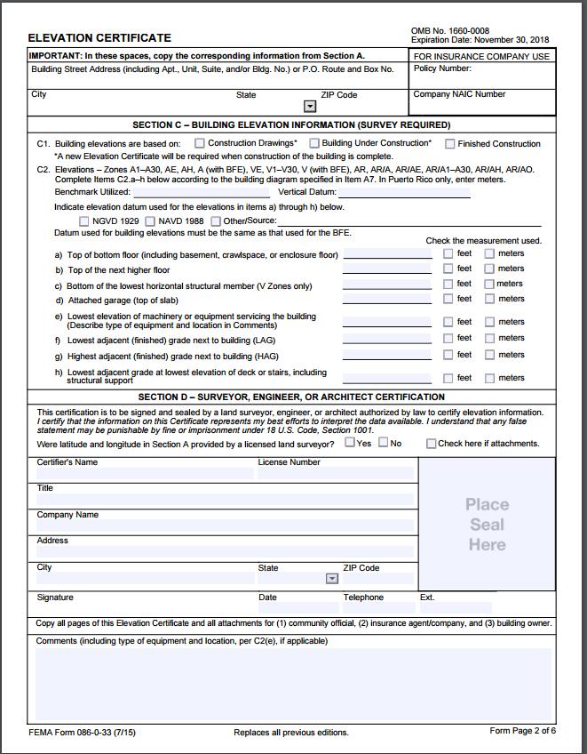
SPECIAL CERTIFICATIONS
 SPECIAL CERTIFICATIONS This section presents detailed instructions for the completion of the National Flood Insurance Program (NFIP) Elevation Certificate (EC) and the NFIP Floodproofing Certificates.
Florida Division of Emergency Management
 2017 FLOODPLAIN MANAGEMENT IN FLORIDA Florida Division of Emergency Management Bureau of Mitigation State Floodplain Management Office 2555 Shumard Oak Boulevard, Tallahassee, FL 32399 www.floridadisaster.org/mitigation
MT-1 Basics: A Comprehensive Overview of LOMAs and Discussion of Common Application Setbacks
 MT-1 Basics: A Comprehensive Overview of LOMAs and Discussion of Common Application Setbacks Introduction: Terminology MT-1s vs. MT-2s LOMAs vs. LOMRs What is a LOMC? Letters of Map Change (LOMCs) MT-1s
DELTA COUNTY FLOOD DAMAGE PREVENTION REGULATIONS CERTIFIED BY THE. Delta County Planning Commission September 26, 2013 ADOPTED BY THE
 DELTA COUNTY FLOOD DAMAGE PREVENTION REGULATIONS CERTIFIED BY THE Delta County Planning Commission September 26, 2013 ADOPTED BY THE Board of Delta County Commissioners December 9, 2013 REVISED BY THE
1. STATUTORY AUTHORIZATION, FINDINGS OF FACT, AND PURPOSES... 2
 ORDINANCE NO. 15-03 CAPE GIRARDEAU COUNTY FLOODPLAIN MANAGEMENT ORDINANCE ARTICLE # PAGE # 1. STATUTORY AUTHORIZATION, FINDINGS OF FACT, AND PURPOSES... 2 2. GENERAL PROVISIONS... 3 3. ADMINISTRATION...
Michigan Department of Environmental Quality 525 West Allegan Street Lansing, MI (517)
") FLOODPLAIN MANAGEMENT IN MICHIGAN 2002 John Engler, Governor Russell J. Harding, Director Michigan Department of Environmental Quality 525 West Allegan Street Lansing, MI 48909 (517) 373-1170 www.michigan.gov/deq
FLOODPLAIN MANAGEMENT IN MICHIGAN 2002 John Engler, Governor Russell J. Harding, Director Michigan Department of Environmental Quality 525 West Allegan Street Lansing, MI 48909 (517) 373-1170 www.michigan.gov/deq
YOLO COUNTY FLOODPLAIN MANAGEMENT PROGRAM
 YOLO COUNTY FLOODPLAIN MANAGEMENT PROGRAM Answers to Commonly Asked Questions and A Guide for Residential Construction Within Special Flood Hazard Areas The automatic entry and exit of flood water); Or
D R A F T. Flood Damage Prevention Regulations Huerfano County Colorado. CWCB Redline Review SECTION 1.0
 Flood Damage Prevention Regulations Huerfano County Colorado SECTION 1.0 STATUTORY AUTHORIZATION, FINDINGS OF FACT, PURPOSE AND OBJECTIONS 1.1 STATUTORY AUTHORIZATION The Legislature of the State of Colorado
AMENDMENTS TO CHAPTER 50: FLOODPLAIN DEVELOPMENT
 AMENDMENTS TO CHAPTER 50: FLOODPLAIN DEVELOPMENT PART I: 2018 FLOOD MAP IMPLEMENTATION PART II: STRATEGIES TO IMPROVE THE CITY S COMMUNITY RATING SYSTEM SCORE NATIONAL FLOOD INSURANCE PROGRAM (NFIP) CREATED
Oak Island 1999 Hurricane Floyd
 Oak Island 1999 Hurricane Floyd Topics to be Discussed What is a flood zone Flood zones in Oak Island Special Flood Hazard Areas (SFHA) Flood insurance Base Flood Elevations (BFEs) Building in flood zones
UPSHUR COUNTY FLOODPLAIN ORDINANCE
 UPSHUR COUNTY FLOODPLAIN ORDINANCE AN ORDINANCE ESTABLISHING A FLOODPLAIN AREA AS IDENTIFIED BY THE FEDRAL EMERGENCY MANAGEMENT AGENCY (FEMA); REQUIRING ALL CONTRACTORS, PERSONS, PARTNERSHIPS, BUSINESSES
Chapter 415 FLOODPLAIN MANAGEMENT
 Chapter 415 FLOODPLAIN MANAGEMENT Editor's Note Ordinance no. A-7015 1, adopted December 27, 2000, enacted written administrative procedures for the floodplain management herein. Those written administrative
Introduction to the National Flood Insurance Program: A Guide for Coastal Property Owners MAINE BEACHES CONFERENCE 2017
 Introduction to the National Flood Insurance Program: A Guide for Coastal Property Owners MAINE BEACHES CONFERENCE 2017 SUE BAKER, CFM STATE NFIP COORDINATOR MAINE DEPT OF AGRICULTURE, CONSERVATION & FORESTRY
Article 11: Floodplain Management
 Section 241: Definitions Article 11: Floodplain Management Unless specifically defined below, words or phrases used in this article shall be interpreted so as to give them the same meaning they have in
Enough about me! Topics Covered
 About Me Worked in land surveying since 1997 Employed by the City of Orlando since 2006 City of Orlando City Surveyor since February 2015 Certified Floodplain Manager since 2015 Florida Licensed Surveyor,
History of Floodplain Management in Ascension Parish
 History of Floodplain Management in Ascension Parish presented by: Kara Moree Floodplain Coordinator February 6, 2012 Floodplain 101 Floodplain 101 Base or 1% Flood: A flood having a 1% chance of being
CONTRA COSTA COUNTY FLOODPLAIN MANAGEMENT PROGRAM
 CONTRA COSTA COUNTY FLOODPLAIN MANAGEMENT PROGRAM Answers to Commonly Asked Questions and A Guide for Residential Construction Within Special Flood Hazard Areas Revised February 2015 Introduction Ninety
WOOD COUNTY, WV FLOODPLAIN ORDINANCE TABLE OF CONTENTS
 WOOD COUNTY, WV FLOODPLAIN ORDINANCE TABLE OF CONTENTS ARTICLE I - GENERAL PROVISIONS 3 Section 1.1 Intent 3 Section 1.2 Abrogation and Greater Restrictions 3 Section 1.3 Applicability 3 Section 1.4 Matters
2011 FLOODPLAIN MANAGEMENT ORDINANCE FOR LINCOLN COUNTY
 2011 FLOODPLAIN MANAGEMENT ORDINANCE FOR LINCOLN COUNTY First Reading: September 13, 2011 Second Reading: September 27, 2011 Publication Date: October 6, 2011 and October 13, 2011 Effective Date: November
National Institute of Building Sciences
 National Institute of Building Sciences Provider Number: G168 Improving the Flood Resistance of Buildings and Mitigation Techniques WE3B Peter Spanos, P.E., CFM, LEED AP (Gale Associates, Inc.) Stuart
A Floodplain Management District (FMD) is needed for the following reasons:
 is needed for the following reasons:") 703 FLOODPLAIN MANAGEMENT DISTRICT (FMD) 703.01 FINDINGS OF FACT A Floodplain Management District (FMD) is needed for the following reasons: A. Flood Losses Resulting from Periodic Inundation: The flood
703 FLOODPLAIN MANAGEMENT DISTRICT (FMD) 703.01 FINDINGS OF FACT A Floodplain Management District (FMD) is needed for the following reasons: A. Flood Losses Resulting from Periodic Inundation: The flood
Appendix B. A Comparison of the Minimum NFIP Requirements and the CRS
 A Comparison of the Minimum s and the CRS The Community Rating System provides credits for exceeding the minimum requirements of the National Flood Insurance Program (NFIP). Many local officials are not
Floodplain Management Annual Conference Atlanta, Georgia April 2017
 Floodplain Management 2017 Annual Conference Atlanta, Georgia April 2017 Floodplain Mapping and Flood Zones Zone Deisgnations: Zone A: No base flood elevations have been determined it is an approximated
Mistakes on Elevation Certificates
 Mistakes on Elevation Certificates What is the Base Flood Elevation (BFE) & how do you determine it? FIRM Map Panel? Flood Insurance Study? o Profile Sheet o Floodway Data Chart o Stillwater Chart Community
ATTACHMENT A SUMMARY OF THE NFIP OCTOBER 2013 PREMIUM RATE AND RULE CHANGES
 ATTACHMENT A SUMMARY OF THE NFIP OCTOBER 2013 PREMIUM RATE AND RULE CHANGES National Flood Insurance Program October 1, 2013, Premium Rate and Rule Changes: A Summary 1. Premium Increases Premiums will
TOWN OF BLOOMFIELD FLOOD HAZARD AREA ZONING BYLAW
 TOWN OF BLOOMFIELD FLOOD HAZARD AREA ZONING BYLAW Lands to Which These Regulations Apply These regulations shall apply for development in all area's in the Town of Bloomfield, Vt. identified as areas of
Now forget it all for the next 90 minutes.
 Karol L. Grove, PS Get ready to think outside of the box. Get ready to think about surveying, flood zones and flood insurance in a whole new light.. Think about everything you think you know about Elevation
F L F fl OOO O573. ?5JN 8 HI!:62 OF CRCJi GJh DORCHESTER COUNTY, MARYLANDORCHFSiER county
 OOO O573 COUNTY COUNCIL F L F fl?5jn 8 HI!:62 OF CRCJi GJh DORCHESTER COUNTY, MARYLANDORCHFSiER county 2015 Legislative Session, Legislative Day No. 1, 2015 Introduced by: County Council Bill No. 2015-1
ORDINANCE # FLOOD DAMAGE PREVENTION ORDINANCE STATUTORY AUTHORIZATION, FINDINGS OF FACT, PURPOSE AND METHODS
 ORDINANCE # 304 - FLOOD DAMAGE PREVENTION ORDINANCE ARTICLE I STATUTORY AUTHORIZATION, FINDINGS OF FACT, PURPOSE AND METHODS SECTION A. STATUTORY AUTHORIZATION The Legislature of the State of South Dakota
North Carolina Department of Public Safety Emergency Management Risk Management
 North Carolina Department of Public Safety Emergency Management Risk Management Roy Cooper, Governor Erik A. Hooks, Secretary Michael A. Sprayberry, Director INSTRUCTIONS FOR COMPLETING THE NORTH CAROLINA
City of St. Augustine. Floodplain Management Higher Standards Information
 City of St. Augustine Floodplain Management Higher Standards Information There are different regulations that communities can use to help protect existing and future development and natural floodplain
Door County Floodplain Program Informational Meeting
 Door County Floodplain Program Informational Meeting Door County Land Use Services Department Wisconsin Department of Natural Resources January 15, 2018 Floodplain = Land affected by flood event with a
FLOOD INSURANCE. Introduction
 FLOOD INSURANCE Introduction The purpose of this course is to provide a comprehensive description of the NFIP for insurance producers who are seeking continuing education credits. It provides an overview
Gail Moldovan-Trujillo, ACSR,CPIW Hagan Hamilton Insurance 2012 NFIP Agency of the year Flood Insurance Specialist & Consultant
 Gail Moldovan-Trujillo, ACSR,CPIW Hagan Hamilton Insurance 2012 NFIP Agency of the year Flood Insurance Specialist & Consultant Flood Insurance regulations continue to change at a very rapid pace, therefore
Pinellas County Flood Map Information Service & Real Estate Disclosure Program Training January 26, 2017 COMMON FLOODPLAIN ACRONYMS
 FEMA ASFPM BFE CAV Pinellas County Flood Map Information Service & Real Estate Disclosure Program Training COMMON FLOODPLAIN ACRONYMS Federal Emergency Management Agency Association of State Floodplain
National Flood Insurance Program, Biggert-Waters 2012, and Homeowners Flood Insurance Affordability Act 2014
 National Flood Insurance Program, Biggert-Waters 2012, and Homeowners Flood Insurance Affordability Act 2014 Janice Mitchell, Insurance Specialist Floodplain Management and Insurance Branch FEMA Region
FLOOD DAMAGE PREVENTION ORDER. Hill County, Texas
 FLOOD DAMAGE PREVENTION ORDER Hill County, Texas June 10 2014 FLOOD DAMAGE PREVENTION ORDER Hill County, Texas TABLE OF CONTENTS ARTICLE 1 STATUTORY AUTHORIZATION, FINDINGS OF FACT, PURPOSE AND METHODS...
Wetzel County Floodplain Ordinance
 Wetzel County Floodplain Ordinance AUTHORITY AND PURPOSE: THE PROVISIONS OF THIS ORDINANCE HAVE BEEN PREPARED WITH THE INTENTION OF MEETING THE REQUIREMENTS OF SECTION 60.3 (D) OF THE NATIONAL FLOOD INSURANCE
Flood Insurance for Local Officials and Floodplain Managers. What Every Community Official Needs to Know About Flood Insurance
 Flood Insurance for Local Officials and Floodplain Managers What Every Community Official Needs to Know About Flood Insurance Illinois Association for Floodplain and Stormwater Management 2011 Annual Conference
Frequently Asked Questions and Answers Concerning Flood Insurance
 Frequently Asked Questions and Answers Concerning Flood Insurance Sources Used: (1) www.floodsmart.gov (2) National Flood Insurance Program, Answers to Questions about the NFIP, FEMA F-084/ March 2011.
CHAPTER 160 FLOOD PLAIN REGULATIONS
 CHAPTER 160 FLOOD PLAIN REGULATIONS 160.01 Statutory Authority 160.13 Special Shallow Flooding Areas Standards 160.02 Findings of Fact 160.14 Administration 160.03 Purpose 160.15 Flood Plain Development
BERKELEY COUNTY FLOODPLAIN ORDINANCE
 . BERKELEY COUNTY FLOODPLAIN ORDINANCE i~ll :~~\I :-:~ ~( ~~< ~~:~ ----...r~i :-- \J.. '- ' t ~...~ '/ :.- f '. ~ ~ L ~._ ~~' w ~t i.~.~~~rt i l.- --.~. ' I ' e II... \... -'. ' '
RIO ARRIBA COUNTY FLOOD DAMAGE PREVENTION ORDINANCE
 RIO ARRIBA COUNTY FLOOD DAMAGE PREVENTION ORDINANCE NO. 1982-1 RE VISED 1988-2 AMENDED 2008-01 RIO ARRIBA J. FRED VIGIl, COUNTY CLERK 200707904 Book 530 Page 7904 1 of 22 10/30/2007 O8:5Q ~~ AM BY 1 FLOOD
THE FLOOD HAZARD AREA Valda Opara New Jersey Department of Environmental Protection June 8, 2012
 THE FLOOD HAZARD AREA Valda Opara New Jersey Department of Environmental Protection June 8, 2012 Individual Permits Building Requirements 0% Net-fill Standards JET SKIING DURING A FLOOD ESCAPING THE FLOOD
California Building Code and the NFIP. John Ingargiola, Senior Engineer FEMA Building Science Branch
 California Building Code and the NFIP John Ingargiola, Senior Engineer FEMA Building Science Branch CA Major Disaster Declarations and Federal Assistance $21 $21 $76 $78 7 declarations, 2004-2016, total
FLOOD PLAIN DEVELOPMENT ORDINANCE
 FLOOD PLAIN DEVELOPMENT ORDINANCE DES MOINES COUNTY, IOWA ORDINANCE NO. 25 Adopted July 19, 1993 Amended July 26, 1993 Amended January 3, 1995 Amended August 7, 2011 Amended October 16, 2015 TABLE OF CONTENTS
Upper Joachim Creek Public Survey on Potential Flood Risk Reduction
 Upper Joachim Creek Public Survey on Potential Flood Risk Reduction This survey is intended to help the interagency planning committee to receive public feedback on specific flood risk reduction techniques,
Federal Emergency Management Agency
 Page 1 of 5 Issue Date: July 27, 2012 Effective Date: December 10, 2012 Case No.: 11-06-4512P Follows Conditional Case No.: 06-06-B789R LOMR-APP Federal Emergency Management Agency Washington, D.C. 20472
Pre-Development Floodplain Application
 Pre-Development Floodplain Application The Department of Planning, at the recommendation of FEMA, is now requiring completion of a Pre- Development Floodplain Application for all properties in the regulated
Model B E. Flood Damage Prevention Ordinance 4/11
 Model B E Flood Damage Prevention Ordinance 4/11 The following information is provided to assist you in developing an ordinance that will comply with the minimum participating criteria of the National
Federal Emergency Management Agency
 Page 1 of 4 Issue Date: September 7, 2012 Effective Date: January 22, 2013 DETERMINATION DOCUMENT COMMUNITY COMMUNITY AND REVISION INFORMATION City of Lubbock Lubbock County Texas PROJECT DESCRIPTION CHANNELIZATION
Durham County Preliminary Flood Hazard Data Public Meeting. July 28, 2016
 Durham County Preliminary Flood Hazard Data Public Meeting July 28, 2016 Why Are We Here New flood hazard data has been released as Preliminary for Durham County Statutory Due Process for review/comments
Indiana Department of Natural Resources Division of Water
 2018 FLOODPLAIN MANAGEMENT IN INDIANA Indiana Department of Natural Resources Division of Water 402 W. Washington St., Room W264 n Indianapolis, IN 46204 317-232-4160 n in.gov/dnr/water Table of Contents
Kentucky Division of Water Permitting Floodplain Overview and Considerations
 Kentucky Division of Water Permitting Floodplain Overview and Considerations Presentation to: 2014 KAMM Conference Lake Barkley State Resort Park by Solitha Dharman Department for Environmental Protection
NESHOBA COUNTY, MISSISSIPPI FLOOD DAMAGE PREVENTION ORDINANCE
 NESHOBA COUNTY, MISSISSIPPI FLOOD DAMAGE PREVENTION ORDINANCE January 22, 2019 NESHOBA COUNTY, MISSISSIPPI FLOOD DAMAGE PREVENTION ORDINANCE TABLE OF CONTENTS ARTICLE 1. STATUTORY AUTHORIZATION, FINDINGS
Maryland Model Floodplain Management Ordinance (May, 2014) MODEL NOTES
 MODEL NOTES") Maryland Model Floodplain Management Ordinance (May, 2014) MODEL NOTES The model floodplain management ordinance that most Maryland communities have used as the basis for their regulations since the early
Maryland Model Floodplain Management Ordinance (May, 2014) MODEL NOTES The model floodplain management ordinance that most Maryland communities have used as the basis for their regulations since the early
SACRAMENTO COUNTY FLOODPLAIN MANAGEMENT ORDINANCE. EFFECTIVE April 24, 2010
 SACRAMENTO COUNTY FLOODPLAIN MANAGEMENT ORDINANCE EFFECTIVE April 24, 2010 INTRODUCTION April 24, 2010 Sacramento County has participated in the National Flood Insurance Program since 1979. A County Floodplain
Requirements for Construction on Properties in the Special Flood Hazard Area (SFHA)
") Requirements for Construction on Properties in the Special Flood Hazard Area (SFHA) Rev 010915 The website for the IDNR to request the EFARA (Electronic Floodplain Analysis/Regulatory Assessment is found
Requirements for Construction on Properties in the Special Flood Hazard Area (SFHA) Rev 010915 The website for the IDNR to request the EFARA (Electronic Floodplain Analysis/Regulatory Assessment is found
ATTACHMENT 1. Amendments to Chapter 18.20, Definitions Area of shallow flooding Area of special flood hazard
 Amendments to Chapter 18.20, Definitions 18.20.206 Area of shallow flooding Area of shallow flooding means a designated AO, or AH, AR/AO, AR/AH, or VO Zone on the a community's flood insurance rate map
April 2, Write Your Own Principal Coordinators and the NFIP Servicing Agent
 U.S. Department of Homeland Security 500 C Street, SW Washington, DC 20472 W-09021 April 2, 2009 MEMORANDUM TO: Write Your Own Principal Coordinators and the NFIP Servicing Agent FROM: SUBJECT: Edward
INSTRUCTIONS FOR COMPLETING THE APPLICATION FORMS FOR CONDITIONAL LETTERS OF MAP REVISION AND LETTERS OF MAP REVISION
 INSTRUCTIONS FOR COMPLETING THE APPLICATION FORMS FOR CONDITIONAL LETTERS OF MAP REVISION AND LETTERS OF MAP REVISION GENERAL In 1968, the U.S. Congress passed the National Flood Insurance Act, which created
Why do we care about floodplains?
 NFIP 101 Outline What is the NFIP? What are its goals? What is a flood? A floodplain? Maps, FIRMs, and FISs NFIP Requirements Local Flood Ordinances & Permitting Tips, Tricks, & Tools Mitigation & Other
11/18/2011. FEMA All rights reserved. FEMA All rights reserved. Session Overview
 3 Session Overview 4 1 Welcome to Session 2 of the FEMA NFIP Agent Training Program! Dorothy Martinez Rich Slevin Recall your learning from the previous session and share at least one important takeaway.
Federal Emergency Management Agency
 Page 1 of 4 Issue Date: April 26, 2013 DETERMINATION DOCUMENT COMMUNITY AND REVISION INFORMATION PROJECT DESCRIPTION BASIS OF REQUEST City of Coppell Dallas County Texas FILL HYDRAULIC ANALYSIS NEW TOPOGRAPHIC
Floodplain Design, Construction, and Impacts On Flood Insurance
 Floodplain Design, Construction, and Impacts On Flood Insurance AIA/CES Registration Architectural Record is a registered provider with The American Institute of Architects Continuing Education Systems.
COLLIER COUNTY FLOODPLAIN MANAGEMENT
 COLLIER COUNTY FLOODPLAIN MANAGEMENT FREQUENTLY ASKED QUESTIONS The following information is based on common questions from the public. If you have a specific question or need further information, please
Federal Emergency Management Agency
 Page 1 of 4 Issue Date: October 2, 2017 Effective Date: October 2, 2017 Case No.: 17-09-2731P LOMR-APP Federal Emergency Management Agency Washington, D.C. 20472 LETTER OF MAP REVISION DETERMINATION DOCUMENT
ORDINANCE NO. 246 FLOOD DAMAGE PREVENTION ORDINANCE STATUTORY AUTHORIZATION, FINDINGS OF FACT, PURPOSE, AND OBJECTIVES
 ORDINANCE NO. 246 FLOOD DAMAGE PREVENTION ORDINANCE Article I. Section A. STATUTORY AUTHORIZATION, FINDINGS OF FACT, PURPOSE, AND OBJECTIVES Statutory Authority The Legislature of the State of Idaho, pursuant
Zone A. Non Studied Area? Where do we go? Establishing the BFE. Bridge Design 1/9/2019
 Karol L. Grove Licensed Professional Surveyor Certified Floodplain Manager 1 Establishing the BFE Zone A Where do we go? Non Studied Area? 2 Bridge Design 3 1 4 5 6 2 Look at the age of the culvert or
10526 Bermuda Isle Dr. Tampa, FL 33647
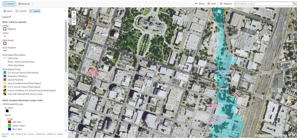
 Flood Analysis Memo Property Address In Partnership with: ** This property is NOT within a high-risk flood zone ** This property is located in a FEMA low-risk zone designated as Zone X - an area of minimal