Kentucky Division of Water Permitting Floodplain Overview and Considerations
|
|
|
- Basil Garrett
- 5 years ago
- Views:
Transcription
1 Kentucky Division of Water Permitting Floodplain Overview and Considerations Presentation to: 2014 KAMM Conference Lake Barkley State Resort Park by Solitha Dharman Department for Environmental Protection Energy & Environment Cabinet To Protect and Enhance Kentucky s Environment
2
3


4 ???


5 5

6 Floodplain Management Priorities Creating stronger and safer communities Reduces loss of life and property Lessens financial impacts Enables individuals and localities to prepare for future events
7 Located in Chapter 44 of Code of Federal Regulations (44 CFR) Part 59 General Provisions Part 60 Criteria for Land Management and Use Primary Section of Concern for Floodplain Regulations: 44 CFR 60.3(a-e)
8 DOW Floodplain management Website
9 Floodplain Management Section Administrative Staff Specialists/Technical Kate Carigan Kathy Allen Permit Reviewers Engineers Todd Powers (Supervisor) Jim Oerther Ross Bishop Kourosh Namin Soheyl Bigdeli Solitha Dharman NFIP Todd Powers & Abby Rains 9 Permitting Workload projects projects projects 13% average exemption 11% average Denied, Terminated, Withdrawn, No Approval Req. Typically 200 projects per reviewer per year (slightly less now with new additional personnel) NFIP Workload CAP SSSE Community Support Services Element 40 Community visits annually CAV, CAC training classes for local floodplain administrators as required by FEMA
10 KRS Requiring secretary of the cabinet to establish requirements for flood control and water resources KY Regulations KRS : Authorize cabinet establishes minimum standards for floodplain management Plans for dams, levees, etc. to be approved and permit issued by cabinet -- Jurisdiction of Department for Natural Resources KAR 4:060- Stream Construction Criteria
11 401 KAR 4:60 Sec#1- Definitions Sec#2-Applicability Sec#3- General Provisions Sec#4- Uses of Regulatory Floodway Sec#5-Floodway Boundary Determination Sec#6-Placement of Flood-damageable Property Sec#7-Types of Construction Materials Allowed Sec#8-Variances and Exceptions Sec#9-Incorporation by Reference
12 Types of Approvals Permit Conditions with a Approval Letter Permit Exemption Letter
13 When Application is Required All mapped flood zone areas except 500 year zones. Any construction along or across a stream. Any residential or commercial structure in an area subject to inundation. Any water impounding structure. 13
14 Types of Construction Applications KYDOW Review Construction in Floodplain Construction in Floodway ( Projects involve with Floodway Encroachment) 14
15 Types of Constructions Stream Crossing-subfluvial(Directional Boring or Open Cut methods ) Stream Banks Restoration Streams Realignment, Relocation Culvert/Bridge New construction, Replacement 15
16 The Application Review Process Phase 1 Review the application package for Administrative completeness Phase 2 Review the application package for Technical compliance with technical requirements (Regulations) Phase 3 Approve or deny the application - by Permit Reviewers and make their recommendation to section supervisor for final decision. Phase 4 Generation of permits/approval letters - mail and/or to Applicant,Local Floodplain Coordinator,Consultant
")
17 Review Time Clock in TEMPO Database ( 20 Working Days when application is complete ) 17

18 KRS 151 KRS How is stream defined? Common Misconceptions It s not a Blue Line Stream It s not a Perennial Stream "stream" or "watercourse" means any river, creek or channel, having well defined banks in which water flows for substantial periods of the year to drain a given area, or any lake or other body of water in the 18 Commonwealth
19 Two Paths for Application Review Mapped Areas Use DFIRMs Use FIRMs Unmapped Areas What is the nature of the construction. Is this a threat to life or property. What is the watershed area. 19
20 Permit Exemptions 4:050 Less than 1mi 2 exemption Does not always apply. Does not apply to water impounding structures. Subfluvial Crossings Streambed must be returned to original elevation. Pipe must be anchored or be sufficiently weighted to resist flotation. 20
21 Example of Permit Exemption: -Minor Stream Bank Stabilization- 21

22 Less than 1mi 2 exemption does not apply to: Any activity that may endanger life Activity that may damage residential or commercial structures. Water impounding structures. DOW can choose not to exempt any project. 22

23 Floodplain Construction Application 23
24 Local Floodplain Coordinator s and owner s Signatures are Required We MUST have both the owner and Floodplain Coordinator signatures, without either of these a Notice of Deficiency will be issued and the application does not get reviewed

25 Provide details of the project location relative to the stream


26 Stream Bank Stabilization Need Site Details Section view Plan View 26
27 Certification of Ownership of the project location must be provided This is one of the most common reasons for a Notice of Deficiency (NOD) to be issued and delay the processing of the application
28 401 KAR 4:60 Sec #3 General Provisions (4) Public Notification 28
29 Public Notice Information The Newspaper Notice shall run for a period of three (3) consecutive days or printing If published weekly or bi-weekly - two (2) consecutive printing allowed when requested in writing If impact is localized - Submit affidavit from all parties Under certain situations, if flood impacts are negligible - Division may waive this requirement 29
30 Public Notice Information The Newspaper Notice shall run for a period of three (3) consecutive days or printing If published weekly or bi-weekly - two (2) consecutive printing allowed when requested in writing If impact is localized - Submit affidavit from all parties Under certain situations, if flood impacts are negligible - Division may waive this requirement 30


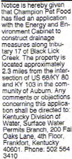
31 Example of Public Notice 31
32 Submit Actual copy of the Notice or Affidavit of Publication 32
33 Affidavit of Understanding If impact is localized Submit affidavit from all parties
34 REQUEST FOR ADMINISTRATIVE HEARING REQUEST If applicant think DOW did not follow regulations during the permitting process, Hearing can be requested Someone filing a complaint can request an Administrative Hearing 34
 Is not a flood that occurs every 100 years!")
35 Base Flood-Several Definitions Base flood is the 100 year flood event. (1% chance of being equaled or exceeded base flow in a year) Is not a flood that occurs every 100 years! Has a 26% chance of occurring during a 30 yr period 35
36 What You Need to Know! FIRM s, DFIRM s, and FHBM s were not intended to be comprehensive or exclusive tool for floodplain management. Can be used as a tool in mapped areas. Cannot be used to determine all flood prone areas. Every stream has a floodplain and floodway. May or may not be shown on a map. Users include: citizens, insurance agents, real estate brokers, local, state and federal officials, lending institutions 36
37 Typical Zones Zone AE -Zones that have a detailed flood study. Floodway boundaries are usually available. BFE is available Zone A -Approximate floodplain area. No BFE or Floodway boundary established. Zone X -Areas of 500 year or shallow (<1foot) 100 year flooding. Zone X Areas outside of 0.2% annual chance floodplain. 37
")
38 Flood Insurance Rate Map (FIRM) 38
 High hazard flood zone Zone AE High")
39 FIRM Maps Shaded Zone X - Moderate hazard flood zone Zone AE (floodway) High hazard flood zone Zone AE High hazard flood zone Unshaded Zone X Low hazard flood zone Zone A High hazard flood zone

40 Floodplain and Floodway Identification Floodplain Floodway
41 FLOODWAY SCHEMATIC 100 YEAR FLOODPLAIN FLOOD WAY 1 Feet SURCHARGE Base Flood Elevation (BFE) 41
42 HEC-RAS Overbank stations and Main Channel
43 HECRAS Encroachment Method #4 Which is called The equal Loss of Conveyance Method. Where it removes equal amount of conveyance from both overbank areas. If equal conveyance cannot be achieved, HEC-RAS will stop at the bank station and would not go into the channel.
44 401 KAR 4:060 Sec #4 Uses of Regulator Floodway All encroachments (Except as provided in subsection#2), including fill, new construction substantial improvements and other development is prohibited unless certified that encroachment shall have no impact or not result in increase in flood levels during base flood discharge by a licensed engineer. 44
45 Floodway Boundary Determination More Stringent Requirements May Apply- Section #5 (3) In areas Where one or more houses or commercial or industrial buildings located, if one (1) foot increase creates in increase of flood damages, cabinet may impose more stringent limitations
46 In Performing Floodway Calculations The applicant provide cross sections NGVD 1929 or NAVD 1988 Vertical error tolerance of no more than 0.5 foot Cross Sections to be taken a those points indicates significant break in slope hydraulic characteristics near adjacent structures to be impacted Cross Sections shall be in tabular,electronic format Cabinet may request photo graphs and other information in determination of roughness values
47 401 KAR 4:060, Sec 5: Determining Regulatory Floodway Boundaries KYDOW use HECRAS Hydraulic Analysis Needs Cross Sections 47
48 Cross sections need to be identified on the site plan 48

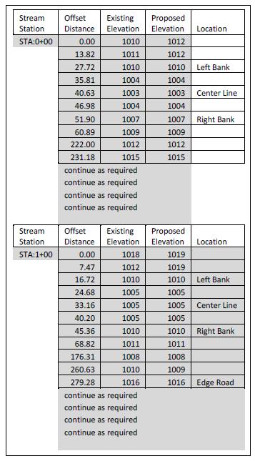
49 Sample Format for Cross-Section Data 49
50 Flood Flow in the HECRAS Model Ineffective Flow Areas In order to avoid underestimating the BFE, areas with low or zero flows need to be identified as ineffective stations in the model. Peak flow values need be accordance with the methods in section # 5. If FIS available, flow data need to be obtained from FIS study. 50

51 Ineffective Flow Station Upstream of a Bridge 51
52 401KAR 4:060 Section #5 DOW s first preference is using FIS flow data Unregulated streams such as releases from dams- Estimating the magnitude of peak flowusing USGS regression equation 52
53 Flood Insurance Study FIS provides technical data about the flood study Appraises a community's flood problems Estimates flood flow frequency Establishes flood elevation profiles and floodplain boundaries Provides data to delineate floodways in some communities
54 Floodway Data Table
 to Base Food Elevation.")
55 401 KAR 4:060Section #6 Elevation Requirement of Residential Structures All new Constructions/ substantial improvements Elevate lowest floor (including basement) to Base Food Elevation. No Dry Floodproofing is permitted in Residential structures below Base Flood Elevation
56 Requirements for Full Enclosures-Residential All new Constructions / substantial improvements of existing structures or elevated structures that include full enclosure area formed by foundation exterior walls - design with application of wet flood proof below the base flood - Provide minimum of 2 openings = total net area not less - Bottom of the openings no higher than interior grade than 1 square inch for every square foot of enclosed area.

57 Flood Venting - Covers Examples of Opening Covers Screening Louver Grate Openings may be equipped with screens, louvers, valves, or other automatic coverings
58 401 KAR 4:060Section #6 Elevation Requirement of Non-Residential Structures Elevate lowest floor (including basement) to Base Flood Elevation. or design with application of dry flood proof below the base flood to prevent passage of water and resist hydrostatic and hydrodynamic loads and effects of buoyancy.
59 Substantial Improvement Any Substantial improvement that increases the current market value of a structure by 50%, considered as new construction. Market value of a structure is (a) Appraised fair market value (b) If damaged has occurred, fair market value of the structure before damage
60 Substantial Damage Damage of any origin sustained by a structure whereby the cost of restoring the structure to its before damaged condition would equal or exceed 50% of the market value of the structure before the damage occurred.
 Manufactured Home Parks")
61 401 KAR 4:060 Section #6 (e) Manufactured Home Parks 61
 feet above grade and properly anchored.")
62 New installation of a manufactured home should be raised to BFE If placed in an existing manufacture home park or subdivision the homes shall be elevated no les than three (3) feet above grade and properly anchored. 62
63 Manufactured home with Substantial Damage If placed in an existing manufactured home park or subdivision shall be elevated to the base flood elevation and properly anchored. The expansion of an existing manufactured home park or subdivision constitutes new construction and placement in the newly developed area shall conform to both base flood elevation and anchoring requirements.
64 Exceptions Exceptions to Placement of flood-damageable Property in Floodplain may be allowed for reconstruction, rehabilitation or restoration of historic structures Exceptions may be allowed for the requirement of hydraulic or hydrologic study for the placement of City or County Bridge - if capable of passing base flood flow - if no significant changes in elevation and grades of existing and approaches and roadway

65 STREAM CROSSINGS Hydraulic Analysis required all structures across streams except Clear Span Bridge Construction If the deck abutments are recessed within the stream banks with no approach fill and if the cords depth, Including curbs are no greater than 18 inches 65

66 Low Water Crossings Exceptions allowed for the requirement of hydraulic study for Low Water Crossings if the structure is constructed according to cabinets template.
67 Floodplain Construction Violations No Floodplain permit issued If significant amount of construction has been completed. Handled by Dam Safety Section of KY DOW 67
68 Potential General Permits DOW is considering to issue general permits for certain types of activities. Simple construction project requires no change in Base Flood Elevation. Example: Nonsubstantial improvements to residential or non-residential structures.
69 Any Questions?
FREQUENTLY ASKED QUESTION ABOUT FLOODPLAINS Michigan Department of Environmental Quality
 FREQUENTLY ASKED QUESTION ABOUT FLOODPLAINS Michigan Department of Environmental Quality WHAT IS A FLOOD? The National Flood Insurance Program defines a flood as a general and temporary condition of partial
CRISP COUNTY, GEORGIA AND INCORPORATED AREAS
 CRISP COUNTY, GEORGIA AND INCORPORATED AREAS Community Name Community Number ARABI, CITY OF 130514 CORDELE, CITY OF 130214 CRISP COUNTY (UNINCORPORATED AREAS) 130504 Crisp County EFFECTIVE: SEPTEMBER 25,
Article 23-6 FLOODPLAIN DISTRICT
 AMENDING THE CODE OF THE CITY OF PITTSFIELD CHAPTER 23, ZONING ORDINANCE SECTION I That the Code of the City of Pittsfield, Chapter 23, Article 23-6 Floodplain District, shall be replaced with the following:
a) Ensure public safety through reducing the threats to life and personal injury.
 Ensure public safety through reducing the threats to life and personal injury.") SECTION VII: FLOODPLAIN DISTRICT 7-1 Statement Of Purpose The purposes of the Floodplain District are to: a) Ensure public safety through reducing the threats to life and personal injury. b) Eliminate
SECTION VII: FLOODPLAIN DISTRICT 7-1 Statement Of Purpose The purposes of the Floodplain District are to: a) Ensure public safety through reducing the threats to life and personal injury. b) Eliminate
1. STATUTORY AUTHORIZATION, FINDINGS OF FACT, AND PURPOSES... 2
 ORDINANCE NO. 15-03 CAPE GIRARDEAU COUNTY FLOODPLAIN MANAGEMENT ORDINANCE ARTICLE # PAGE # 1. STATUTORY AUTHORIZATION, FINDINGS OF FACT, AND PURPOSES... 2 2. GENERAL PROVISIONS... 3 3. ADMINISTRATION...
NFIP Mapping Issues. Wendy Lathrop, PLS, CFM. Cadastral Consulting, LLC
 NFIP Mapping Issues Cadastral Consulting, LLC NFIP Basic Objectives: Reduce the exposure to flood damages through the use of minimum standards for the placement and design of structures located in flood
FLOOD DAMAGE PREVENTION RULES
 60.3(d) FLOOD DAMAGE PREVENTION RULES ARTICLE 1 STATUTORY AUTHORIZATION, FINDINGS OF FACT, PURPOSE AND METHODS SECTION A. STATUTORY AUTHORIZATION The Legislature of the State of Texas adopted the Flood
Floodplain Development Permit Application
 Floodplain Development Permit Application City of Jonesboro, AR This is an application packet for a Floodplain Development Permit. Certain sections are to be completed by the Applicant, and certain sections
National Flood Insurance Program (NFIP) for Real Estate Professionals
 for Real Estate Professionals") National Flood Insurance Program (NFIP) for Real Estate Professionals 1 Joshua Oyer, CFM Outreach Specialist NFIP State Coordinator s Office at the Texas Water Development Board 2 Outline Introduction
National Flood Insurance Program (NFIP) for Real Estate Professionals 1 Joshua Oyer, CFM Outreach Specialist NFIP State Coordinator s Office at the Texas Water Development Board 2 Outline Introduction
BUTTS COUNTY, GEORGIA AND INCORPORATED AREAS
 BUTTS COUNTY, GEORGIA AND INCORPORATED AREAS Butts County Community Name Community Number BUTTS COUNTY (UNICORPORATED AREAS) 130518 FLOVILLA, CITY OF 130283 JACKSON, CITY OF 130222 JENKINSBURG, TOWN OF
ATTACHMENT 1. Amendments to Chapter 18.20, Definitions Area of shallow flooding Area of special flood hazard
 Amendments to Chapter 18.20, Definitions 18.20.206 Area of shallow flooding Area of shallow flooding means a designated AO, or AH, AR/AO, AR/AH, or VO Zone on the a community's flood insurance rate map
Chapter 415 FLOODPLAIN MANAGEMENT
 Chapter 415 FLOODPLAIN MANAGEMENT Editor's Note Ordinance no. A-7015 1, adopted December 27, 2000, enacted written administrative procedures for the floodplain management herein. Those written administrative
Floodplain Management 101. Mississippi Emergency Management Agency Floodplain Management Bureau
 Floodplain Management 101 Mississippi Emergency Management Agency Floodplain Management Bureau Stafford Act The Stafford Disaster Relief and Emergency Assistance Act (Stafford Act) (Public Law 100-707)
CHAPTER 8 FLOOD PREVENTION AND PROTECTION*
 CHAPTER 8 FLOOD PREVENTION AND PROTECTION* ---------- *Cross reference(s)--drainage commission, 2-111 et seq.; drainage districts created, 2-114; site drainage requirements for manufactured or mobile home
Why do we care about floodplains?
 NFIP 101 Outline What is the NFIP? What are its goals? What is a flood? A floodplain? Maps, FIRMs, and FISs NFIP Requirements Local Flood Ordinances & Permitting Tips, Tricks, & Tools Mitigation & Other
Chapter 6 - Floodplains
 Chapter 6 - Floodplains 6.1 Overview The goal of floodplain management is to reduce the potential risks to both existing and future developments, and infrastructure, in the 100-year floodplain. Over the
Federal Emergency Management Agency
 Page 1 of 4 Issue Date: September 7, 2012 Effective Date: January 22, 2013 DETERMINATION DOCUMENT COMMUNITY COMMUNITY AND REVISION INFORMATION City of Lubbock Lubbock County Texas PROJECT DESCRIPTION CHANNELIZATION
Dealing With Unnumbered A Zones in Maine Floodplain Management
 Dealing With Unnumbered A Zones in Maine Floodplain Management The following is a list of acceptable methods that the State Floodplain Management Coordinator and the Federal Emergency Management Agency
WHEREAS, the base flood elevation set forth within Ordinance No. 351 was intended in all instances to be 18 inches and not two feet ; and,
 ORDINANCE NO. 353 OF THE CITY OF BUCKHANNON, AN ORDINANCE: (1) ESTABLISHING A FLOODPLAIN AREA AND REQUIRING ALL CONTRACTORS, PERSONS, PARTNERSHIPS, BUSINESSES, AND CORPORATIONS TO OBTAIN A PERMIT FOR THE
TOWN OF KENT, CT PLANNING AND ZONING COMMISSION
 TOWN OF KENT, CT PLANNING AND ZONING COMMISSION FLOOD PLAIN MANAGEMENT REGULATIONS Whereas, Congress has determined that a National Flood Insurance Program would alleviate personal hardships and economic
Floodplain Development Permit Application
 Floodplain Development Permit Application **All construction will also require a building permit** This is an application packet for a Floodplain Development Permit. Certain sections are to be completed
Article 11: Floodplain Management
 Section 241: Definitions Article 11: Floodplain Management Unless specifically defined below, words or phrases used in this article shall be interpreted so as to give them the same meaning they have in
CONTRA COSTA COUNTY FLOODPLAIN MANAGEMENT PROGRAM
 CONTRA COSTA COUNTY FLOODPLAIN MANAGEMENT PROGRAM Answers to Commonly Asked Questions and A Guide for Residential Construction Within Special Flood Hazard Areas Revised February 2015 Introduction Ninety
YOLO COUNTY FLOODPLAIN MANAGEMENT PROGRAM
 YOLO COUNTY FLOODPLAIN MANAGEMENT PROGRAM Answers to Commonly Asked Questions and A Guide for Residential Construction Within Special Flood Hazard Areas The automatic entry and exit of flood water); Or
HENRY COUNTY, OHIO SPECIAL PURPOSE FLOOD DAMAGE PREVENTION REGULATIONS TABLE OF CONTENTS
 HENRY COUNTY, OHIO SPECIAL PURPOSE FLOOD DAMAGE PREVENTION REGULATIONS TABLE OF CONTENTS TABLE OF CONTENTS... i-ii SECTION 1.0 STATUTORY AUTHORIZATION, FINDINGS OF FACT PURPOSE AND OBJECTIVES 1.1 STATUTORY
17.13 FLOOD DAMAGE PREVENTION ORDINANCE. Article I. Statutory Authorization, Findings of Fact, Purpose, and Methods
 17.13 FLOOD DAMAGE PREVENTION ORDINANCE Article I Statutory Authorization, Findings of Fact, Purpose, and Methods 17.1301 Statutory Authorization. The Legislature of the State of South Dakota has in (statutes)
WOOD COUNTY, WV FLOODPLAIN ORDINANCE TABLE OF CONTENTS
 WOOD COUNTY, WV FLOODPLAIN ORDINANCE TABLE OF CONTENTS ARTICLE I - GENERAL PROVISIONS 3 Section 1.1 Intent 3 Section 1.2 Abrogation and Greater Restrictions 3 Section 1.3 Applicability 3 Section 1.4 Matters
North Carolina Department of Public Safety Emergency Management Risk Management
 North Carolina Department of Public Safety Emergency Management Risk Management Roy Cooper, Governor Erik A. Hooks, Secretary Michael A. Sprayberry, Director INSTRUCTIONS FOR COMPLETING THE NORTH CAROLINA
Appendix D - Floodplain Documents
 City of Aspen Urban Runoff Management Plan Appendix D - Floodplain Documents 1. Floodplain Development Permit 2. Elevation Certificate and Instructions 3. Floodproofing Certificate for Non-Residential
Table 1: Federal, State and Local Government Rules applicable to LOMRs/CLOMRS submittal
 MnDNR LOMC Guide This document has been prepared by the Minnesota Department of Natural Resources floodplain staff and is intended to provide assistance with LOMR/CLOMR submittals. This information is
UPSHUR COUNTY FLOODPLAIN ORDINANCE
 UPSHUR COUNTY FLOODPLAIN ORDINANCE AN ORDINANCE ESTABLISHING A FLOODPLAIN AREA AS IDENTIFIED BY THE FEDRAL EMERGENCY MANAGEMENT AGENCY (FEMA); REQUIRING ALL CONTRACTORS, PERSONS, PARTNERSHIPS, BUSINESSES
DES MOINES CITY OF TWO RIVERS. Flooding Risk & Impact to Development
 DES MOINES CITY OF TWO RIVERS Flooding Risk & Impact to Development River System Des Moines Flood Protection Des Moines Flood Protection cont. Infrastructure Over 24 miles of levees 21stormwater pump stations
JAXGIS FEMA Flood Hazard Mapping -- Frequently Asked Questions
 Flood Hazard Zone Designations Summary Zones starting with the letter 'A' (for instance, Zone A, Zone AE, Zone AH, Zone AO) denote a Special Flood Hazard Area, which can also be thought of as the 100-year
TOWN OF TUNBRIDGE FLOOD HAZARD AREA ORDINANCE March 18, UPDATE June 17, 2014
 TOWN OF TUNBRIDGE FLOOD HAZARD AREA ORDINANCE March 18,1998 - UPDATE June 17, 2014 1.0 STATUTORY AUTHORIZATION 1.1 To effect the purposes of 10 V.S.A., Chapter 32, and in accord with the Vermont Planning
ORDINANCE NO A FLOOD DAMAGE PREVENTION ORDINANCE
 ORDINANCE NO. 692-14 A FLOOD DAMAGE PREVENTION ORDINANCE WHEREAS, for a community to participate in the National Flood Insurance Program NFIP, it must adopt and enforce floodplain management regulations
DECATUR COUNTY, GEORGIA AND INCORPORATED AREAS
 DECATUR COUNTY, GEORGIA AND INCORPORATED AREAS Community Name Community Number ATTAPULGUS, CITY OF 130541 BAINBRIDGE, CITY OF 130204 BRINSON, TOWN OF 130670 CLIMAX, CITY OF 130542 DECATUR COUNTY (UNINCORPORATED
SECTION 9: MAPS AND DATA
 SECTION 9: MAPS AND DATA Contents 9.1. NFIP Maps and Data... 9-2 9.1.1. Adopting and enforcing NFIP floodplain maps and data... 9-2 9.1.2. Adopting and enforcing more restrictive data... 9-2 9.1.3. Annexations...
2011 FLOODPLAIN MANAGEMENT ORDINANCE FOR LINCOLN COUNTY
 2011 FLOODPLAIN MANAGEMENT ORDINANCE FOR LINCOLN COUNTY First Reading: September 13, 2011 Second Reading: September 27, 2011 Publication Date: October 6, 2011 and October 13, 2011 Effective Date: November
REGION X FLOOD DAMAGE PREVENTION ORDINANCE WASHINGTON MODEL (REVISED 5/13/2004)
") REGION X FLOOD DAMAGE PREVENTION ORDINANCE WASHINGTON MODEL (REVISED 5/13/2004) Close to 300 towns, cities, counties, and tribes within the State of Washington participate in the National Flood Insurance
REGION X FLOOD DAMAGE PREVENTION ORDINANCE WASHINGTON MODEL (REVISED 5/13/2004) Close to 300 towns, cities, counties, and tribes within the State of Washington participate in the National Flood Insurance
Pinellas County Flood Map Information Service & Real Estate Disclosure Program Training January 26, 2017 COMMON FLOODPLAIN ACRONYMS
 FEMA ASFPM BFE CAV Pinellas County Flood Map Information Service & Real Estate Disclosure Program Training COMMON FLOODPLAIN ACRONYMS Federal Emergency Management Agency Association of State Floodplain
FLOOD HAZARD AREA REGULATION TOWN OF GLOVER, VERMONT. Adopted by the Glover Board of Selectmen on June 27, 1991
 FLOOD HAZARD AREA REGULATION TOWN OF GLOVER, VERMONT Adopted by the Glover Board of Selectmen on June 27, 1991 1 TOWN OF GLOVER, VERMONT FLOOD HAZARD AREA REGULATIONS Table of Contents Sec 101: Statutory
RIO ARRIBA COUNTY FLOOD DAMAGE PREVENTION ORDINANCE
 RIO ARRIBA COUNTY FLOOD DAMAGE PREVENTION ORDINANCE NO. 1982-1 RE VISED 1988-2 AMENDED 2008-01 RIO ARRIBA J. FRED VIGIl, COUNTY CLERK 200707904 Book 530 Page 7904 1 of 22 10/30/2007 O8:5Q ~~ AM BY 1 FLOOD
SKOKOMISH RESERVATION FLOOD DAMAGE PREVENTION ORDINANCE TABLE OF CONTENTS
 TABLE OF CONTENTS STATUTORY AUTHORIZATION, FINDINGS OF FACT, PURPOSE, AND OBJECTIVES 6.04.001 Statutory Authorization 6.04.002 Findings of Fact 6.04.003 Statement of Purpose 6.04.004 Methods of Reducing
TOWN OF BLOOMFIELD FLOOD HAZARD AREA ZONING BYLAW
 TOWN OF BLOOMFIELD FLOOD HAZARD AREA ZONING BYLAW Lands to Which These Regulations Apply These regulations shall apply for development in all area's in the Town of Bloomfield, Vt. identified as areas of
THE FLOOD HAZARD AREA Valda Opara New Jersey Department of Environmental Protection June 8, 2012
 THE FLOOD HAZARD AREA Valda Opara New Jersey Department of Environmental Protection June 8, 2012 Individual Permits Building Requirements 0% Net-fill Standards JET SKIING DURING A FLOOD ESCAPING THE FLOOD
Federal Emergency Management Agency
 Page 1 of 4 Issue Date: April 26, 2013 DETERMINATION DOCUMENT COMMUNITY AND REVISION INFORMATION PROJECT DESCRIPTION BASIS OF REQUEST City of Coppell Dallas County Texas FILL HYDRAULIC ANALYSIS NEW TOPOGRAPHIC
FLOOD DAMAGE PREVENTION REGULATION ARTICLE I STATUTORY AUTHORIZATION, FINDINGS OF FACT, PURPOSE AND OBJECTIVES
 CHAPTER 12 FLOOD DAMAGE PREVENTION REGULATION ARTICLE I STATUTORY AUTHORIZATION, FINDINGS OF FACT, PURPOSE AND OBJECTIVES SECTION A. STATUTORY AUTHORIZATION The Legislature of the State of Colorado has,
DELTA COUNTY FLOOD DAMAGE PREVENTION REGULATIONS CERTIFIED BY THE. Delta County Planning Commission September 26, 2013 ADOPTED BY THE
 DELTA COUNTY FLOOD DAMAGE PREVENTION REGULATIONS CERTIFIED BY THE Delta County Planning Commission September 26, 2013 ADOPTED BY THE Board of Delta County Commissioners December 9, 2013 REVISED BY THE
CITIZEN POTAWATOMI NATION PUBLIC CONSERVATION AND ENVIROMENTAL PROTECTION ACT TITLE 35
 CITIZEN POTAWATOMI NATION PUBLIC CONSERVATION AND ENVIROMENTAL PROTECTION ACT TITLE 35 CHAPTER SECTION 1 ESTABLISHMENT OF THE DEPARTMENT OF ENVIRONMENTAL PROTECTION Establishment 101 Required Reporting
Floodplain Management Annual Conference Atlanta, Georgia April 2017
 Floodplain Management 2017 Annual Conference Atlanta, Georgia April 2017 Floodplain Mapping and Flood Zones Zone Deisgnations: Zone A: No base flood elevations have been determined it is an approximated
CHAPTER 15: FLOODPLAIN OVERLAY DISTRICT "FP"
 CHAPTER 15: FLOODPLAIN OVERLAY DISTRICT "FP" SECTION 15.1 STATUTORY AUTHORIZATION The legislature of the State of Minnesota in Minnesota Statutes, Chapter 103F and Chapter 394 has delegated the responsibility
Door County Floodplain Program Informational Meeting
 Door County Floodplain Program Informational Meeting Door County Land Use Services Department Wisconsin Department of Natural Resources January 15, 2018 Floodplain = Land affected by flood event with a
BERKELEY COUNTY FLOODPLAIN ORDINANCE
 . BERKELEY COUNTY FLOODPLAIN ORDINANCE i~ll :~~\I :-:~ ~( ~~< ~~:~ ----...r~i :-- \J.. '- ' t ~...~ '/ :.- f '. ~ ~ L ~._ ~~' w ~t i.~.~~~rt i l.- --.~. ' I ' e II... \... -'. ' '
PARK COUNTY, WYOMING AND INCORPORATED AREAS
 PARK COUNTY, WYOMING AND INCORPORATED AREAS Community Name Community Number CODY, CITY OF 560038 MEETEETSE, TOWN OF 560039 PARK COUNTY UNINCORPORATED AREAS 560085 POWELL, CITY OF 560040 June 18, 2010 Federal
Federal Emergency Management Agency
 Page 1 of 5 Issue Date: June 21, 2013 Follows Conditional Case No.: 04-06-A148R DETERMINATION DOCUMENT COMMUNITY COMMUNITY AND REVISION INFORMATION City of Irving Dallas County Texas FILL PROJECT DESCRIPTION
Chapter 5 Floodplain Management
 Chapter 5 Floodplain Management Contents 1.0 Introduction... 1 2.0 Floodplain Management and Regulation... 1 2.1 City Code... 1 2.2 Floodplain Management... 1 2.3 Level of Flood Protection... 2 2.3.1 Standard
Appendix B. A Comparison of the Minimum NFIP Requirements and the CRS
 A Comparison of the Minimum s and the CRS The Community Rating System provides credits for exceeding the minimum requirements of the National Flood Insurance Program (NFIP). Many local officials are not
A Floodplain Management District (FMD) is needed for the following reasons:
 is needed for the following reasons:") 703 FLOODPLAIN MANAGEMENT DISTRICT (FMD) 703.01 FINDINGS OF FACT A Floodplain Management District (FMD) is needed for the following reasons: A. Flood Losses Resulting from Periodic Inundation: The flood
703 FLOODPLAIN MANAGEMENT DISTRICT (FMD) 703.01 FINDINGS OF FACT A Floodplain Management District (FMD) is needed for the following reasons: A. Flood Losses Resulting from Periodic Inundation: The flood
INSTRUCTIONS FOR COMPLETING THE APPLICATION FORMS FOR CONDITIONAL LETTERS OF MAP REVISION AND LETTERS OF MAP REVISION
 INSTRUCTIONS FOR COMPLETING THE APPLICATION FORMS FOR CONDITIONAL LETTERS OF MAP REVISION AND LETTERS OF MAP REVISION GENERAL In 1968, the U.S. Congress passed the National Flood Insurance Act, which created
CHAPTER 160 FLOOD PLAIN REGULATIONS
 CHAPTER 160 FLOOD PLAIN REGULATIONS 160.01 Statutory Authority 160.13 Special Shallow Flooding Areas Standards 160.02 Findings of Fact 160.14 Administration 160.03 Purpose 160.15 Flood Plain Development
Using GISWeb to Determine Your Property s Flood Zone
 Using GISWeb to Determine Your Property s Flood Zone 1. In a new browser window, go to http://www.co.santacruz.ca.us/departments/geographicinformationsystemsgis.aspx 2. Click on GISWeb - GIS Mapping Application
Federal Emergency Management Agency
 Page 1 of 5 Issue Date: July 27, 2012 Effective Date: December 10, 2012 Case No.: 11-06-4512P Follows Conditional Case No.: 06-06-B789R LOMR-APP Federal Emergency Management Agency Washington, D.C. 20472
Wetzel County Floodplain Ordinance
 Wetzel County Floodplain Ordinance AUTHORITY AND PURPOSE: THE PROVISIONS OF THIS ORDINANCE HAVE BEEN PREPARED WITH THE INTENTION OF MEETING THE REQUIREMENTS OF SECTION 60.3 (D) OF THE NATIONAL FLOOD INSURANCE
D R A F T. Flood Damage Prevention Regulations Huerfano County Colorado. CWCB Redline Review SECTION 1.0
 Flood Damage Prevention Regulations Huerfano County Colorado SECTION 1.0 STATUTORY AUTHORIZATION, FINDINGS OF FACT, PURPOSE AND OBJECTIONS 1.1 STATUTORY AUTHORIZATION The Legislature of the State of Colorado
NFIP Overview Elevation Certificate Flood Insurance Rate Maps. By: Maureen O Shea, AICP, CFM State NFIP Coordinator
 NFIP Overview Elevation Certificate Flood Insurance Rate Maps By: Maureen O Shea, AICP, CFM State NFIP Coordinator Example of a flood failure Example of a flood failure Purposes of the NFIP Identify &
FLOODPLAIN DEVELOPMENT VARIANCE APPLICATION PACKET
 FLOODPLAIN DEVELOPMENT VARIANCE APPLICATION PACKET Sutter County Water Resources Department 1130 Civic Center Boulevard Yuba City, California, 95993 (530) 822-7400 Floodplain management regulations cannot
Skagit County Flood Insurance Study Update. Ryan Ike, CFM FEMA Region 10
 Skagit County Flood Insurance Study Update Ryan Ike, CFM FEMA Region 10 Skagit County Flood Insurance Study Process Overview Process, Schedule, & Deliverables Base Flood Elevations, Modeling, & Levees
Upper Joachim Creek Public Survey on Potential Flood Risk Reduction
 Upper Joachim Creek Public Survey on Potential Flood Risk Reduction This survey is intended to help the interagency planning committee to receive public feedback on specific flood risk reduction techniques,
Floodplain Development Permits A Technical Guidance Document
 Floodplain Development Permits A Technical Guidance Document To Prevent Loss of Life, Reduce Property Damage and to Protect and Enhance the Natural and Beneficial Functions of Floodplains Iredell County
Town of Sharon, Vermont
 FLOOD HAZARD AREA BYLAW Town of Sharon, Vermont White River at Sharon Edward Hopper, 1937 Used with permission from the Smithsonian American Art Museum These Regulations were developed by the Sharon Planning
Pre-Development Floodplain Application
 Pre-Development Floodplain Application The Department of Planning, at the recommendation of FEMA, is now requiring completion of a Pre- Development Floodplain Application for all properties in the regulated
Federal Emergency Management Agency
 Page 1 of 5 Issue Date: April 2, 2015 DETERMINATION DOCUMENT COMMUNITY AND REVISION INFORMATION PROJECT DESCRIPTION BASIS OF REQUEST Ventura County California NO PROJECT UPDATE COMMUNITY (Unincorporated
Federal Emergency Management Agency
 Page 1 of 4 Issue Date: August 1, 2012 Effective Date: December 13, 2012 Case No.: 12-06-0595P LOMR-APP Washington, D.C. 20472 LETTER OF MAP REVISION DETERMINATION DOCUMENT COMMUNITY AND REVISION INFORMATION
FLOOD PLAIN DEVELOPMENT ORDINANCE
 FLOOD PLAIN DEVELOPMENT ORDINANCE DES MOINES COUNTY, IOWA ORDINANCE NO. 25 Adopted July 19, 1993 Amended July 26, 1993 Amended January 3, 1995 Amended August 7, 2011 Amended October 16, 2015 TABLE OF CONTENTS
ORDINANCE NO. 2 Series 2013 TOWN OF PITKIN FLOODPLAIN DAMAGE PREVENTION ORDINANCE
 ORDINANCE NO. 2 Series 2013 TOWN OF PITKIN FLOODPLAIN DAMAGE PREVENTION ORDINANCE FLOOD DAMAGE PREVENTION ORDINANCE TABLE OF CONTENTS ARTICLE I - TITLE AND PURPOSE... 1 SECTION A. STATUTORY AUTHORIZATION...
Bucks County, PA Flood Risk Review Meeting. November 2014
 Bucks County, PA Flood Risk Review Meeting November 2014 Agenda for Today Risk MAP Program overview Overview of non-regulatory Flood Risk Products and datasets Discuss mitigation action Technical overview
Technical Memorandum 3.4 E Avenue NW Watershed Drainage Study. Appendix E Floodplain Impacts and Implications Memo
 Technical Memorandum 3.4 E Avenue NW Watershed Drainage Study Appendix E Floodplain Impacts and Implications Memo September 8, 2017 City of Cedar Rapids E Avenue Watershed Drainage Study Memo Date: Tuesday,
SECTION 6. FLOODPLAIN MANAGEMENT DISTRICT
 SECTION 6. FLOODPLAIN MANAGEMENT DISTRICT Subsection 6.1: Statutory Authorization, Findings of Fact & Purpose A. Statutory Authorization: The legislature of the State of Minnesota has, in Minnesota Statues
Federal Emergency Management Agency
 Page 1 of 6 Issue Date: October 24, 2012 Effective Date: March 7, 2013 Case No.: LOMR-APP DETERMINATION DOCUMENT COMMUNITY AND REVISION INFORMATION PROJECT DESCRIPTION BASIS OF REQUEST City of Lubbock
National Institute of Building Sciences
 National Institute of Building Sciences Provider Number: G168 Improving the Flood Resistance of Buildings and Mitigation Techniques WE3B Peter Spanos, P.E., CFM, LEED AP (Gale Associates, Inc.) Stuart
FLOOD DAMAGE PREVENTION ORDER. Hill County, Texas
 FLOOD DAMAGE PREVENTION ORDER Hill County, Texas June 10 2014 FLOOD DAMAGE PREVENTION ORDER Hill County, Texas TABLE OF CONTENTS ARTICLE 1 STATUTORY AUTHORIZATION, FINDINGS OF FACT, PURPOSE AND METHODS...
FLOOD INSURANCE. Introduction
 FLOOD INSURANCE Introduction The purpose of this course is to provide a comprehensive description of the NFIP for insurance producers who are seeking continuing education credits. It provides an overview
WASHINGTON COUNTY, KENTUCKY AND INCORPORATED AREAS
 WASHINGTON COUNTY, KENTUCKY AND INCORPORATED AREAS COMMUNITY NAME COMMUNITY NUMBER *MACKVILLE, CITY OF 210475 SPRINGFIELD, CITY OF 210220 WASHINGTON COUNTY (UNINCORPORATED AREAS) 210365 *WILLISBURG, CITY
The Future of Floodplain Management in Kentucky
 The Future of Floodplain Management in Kentucky Outline Background Federal Reauthorization Regulation Changes Insurance Changes Disclaimer All changes discussed in this presentation are PROPOSED ONLY.
COLLIER COUNTY FLOODPLAIN MANAGEMENT
 COLLIER COUNTY FLOODPLAIN MANAGEMENT FREQUENTLY ASKED QUESTIONS The following information is based on common questions from the public. If you have a specific question or need further information, please
Federal Emergency Management Agency
 Page 1 of 6 Issue Date: September 27, 2010 Effective Date: February 14, 2011 Follows Conditional Case No.: 08-08-0873R DETERMINATION DOCUMENT COMMUNITY AND REVISION INFORMATION PROJECT DESCRIPTION BASIS
ORDINANCE NO. 246 FLOOD DAMAGE PREVENTION ORDINANCE STATUTORY AUTHORIZATION, FINDINGS OF FACT, PURPOSE, AND OBJECTIVES
 ORDINANCE NO. 246 FLOOD DAMAGE PREVENTION ORDINANCE Article I. Section A. STATUTORY AUTHORIZATION, FINDINGS OF FACT, PURPOSE, AND OBJECTIVES Statutory Authority The Legislature of the State of Idaho, pursuant
Floodplain Management 101: UNIT II. Maps & Flood Insurance Studies
 Floodplain Management 101: UNIT II Maps & Flood Insurance Studies Who is ASFPM? ASFPM stands for the Association of State Floodplain Managers A national organization of floodplain management professionals
ORDINANCE # FLOOD DAMAGE PREVENTION ORDINANCE STATUTORY AUTHORIZATION, FINDINGS OF FACT, PURPOSE AND METHODS
 ORDINANCE # 304 - FLOOD DAMAGE PREVENTION ORDINANCE ARTICLE I STATUTORY AUTHORIZATION, FINDINGS OF FACT, PURPOSE AND METHODS SECTION A. STATUTORY AUTHORIZATION The Legislature of the State of South Dakota
Federal Emergency Management Agency
 Page 1 of 4 Issue Date: October 2, 2017 Effective Date: October 2, 2017 Case No.: 17-09-2731P LOMR-APP Federal Emergency Management Agency Washington, D.C. 20472 LETTER OF MAP REVISION DETERMINATION DOCUMENT
Chapter 113 FLOODPLAIN MANAGEMENT ARTICLE I. IN GENERAL
 Chapter 113 FLOODPLAIN MANAGEMENT Sec. 113-1. Findings of Fact and Purpose. ARTICLE I. IN GENERAL Statutory Authorization: The legislature of the State of Minnesota has, in Minnesota Statutes Chapter 103F
SACRAMENTO COUNTY FLOODPLAIN MANAGEMENT ORDINANCE. EFFECTIVE April 24, 2010
 SACRAMENTO COUNTY FLOODPLAIN MANAGEMENT ORDINANCE EFFECTIVE April 24, 2010 INTRODUCTION April 24, 2010 Sacramento County has participated in the National Flood Insurance Program since 1979. A County Floodplain
CORINTH, VERMONT FLOOD HAZARD AREA BYLAWS. Approved by the Corinth Planning Commission on April 1, 2015
 CORINTH, VERMONT FLOOD HAZARD AREA BYLAWS Approved by the Corinth Planning Commission on April 1, 2015 Adopted by the Corinth Selectboard May 11. 2015 Page1 TABLE OF CONTENTS Section I Section II Section
Federal Emergency Management Agency
 Page 1 of 6 Issue Date: May 13 2016 Case No.: Follows Conditional Case No.: 14-05-0595R DETERMINATION DOCUMENT COMMUNITY AND REVISION INFORMATION PROECT DESCRIPTION BASIS OF REQUEST COMMUNITY Village of
Durham County Preliminary Flood Hazard Data Public Meeting. July 28, 2016
 Durham County Preliminary Flood Hazard Data Public Meeting July 28, 2016 Why Are We Here New flood hazard data has been released as Preliminary for Durham County Statutory Due Process for review/comments
Kevin Wagner Maryland Department of the Environment
 Kevin Wagner Maryland Department of the Environment Topics Overview of the National Flood Insurance Program (NFIP) Mapping Regulations Insurance Mitigation Community Rating System (CRS) Questions Know
Federal Emergency Management Agency
 Page 1 of 5 Issue Date: October 16, 2014 Effective Date: March 2, 2015 Case No.: 14-09-2279P LOMR-APP Federal Emergency Management Agency Washington, D.C. 20472 LETTER OF MAP REVISION DETERMINATION DOCUMENT
Kentucky Floodplain Administrators Handbook
 Kentucky Floodplain Administrators Handbook A Guide for Local Permitting Officials This handbook is published by the Floodplain Management Section of the Department for Environmental Protection, Division
AMENDMENTS TO CHAPTER 50: FLOODPLAIN DEVELOPMENT
 AMENDMENTS TO CHAPTER 50: FLOODPLAIN DEVELOPMENT PART I: 2018 FLOOD MAP IMPLEMENTATION PART II: STRATEGIES TO IMPROVE THE CITY S COMMUNITY RATING SYSTEM SCORE NATIONAL FLOOD INSURANCE PROGRAM (NFIP) CREATED
ORDINANCE NO. ALLAMAKEE COUNTY FLOODPLAIN MANAGEMENT REGULATION
 ORDINANCE NO. AN ORDINANCE APPROVING AND ADOPTING APPROPRIATE LAND USE AND CONTROL MEASURES TO REDUCE FUTURE FLOOD LOSSES IN ALLAMAKEE COUNTY, IOWA IN A MANNER THAT WILL ALLOW THE COUNTY TO PARTICIPATE