Why do we care about floodplains?
|
|
|
- Irma Clemence Hopkins
- 5 years ago
- Views:
Transcription

1 NFIP 101

2 Outline What is the NFIP? What are its goals? What is a flood? A floodplain? Maps, FIRMs, and FISs NFIP Requirements Local Flood Ordinances & Permitting Tips, Tricks, & Tools Mitigation & Other Trainings
 KY has had 78 flood deaths from 1996 2017 KY has 1% of")
3 Why do we care about floodplains? Floodplains are inherently dangerous areas Areas that are most likely to flood (High Risk) KY has had 78 flood deaths from KY has 1% of the U.S. population but accounts for 4% of U.S. flood deaths since


4 Floodplain management should be viewed as a public safety program at the local level
5 National Flood Insurance Program


6 Pre-NFIP Floodplain management was focused on Controlling the flood Dams Levees Reservoirs Channel Modifications
 to provide flood")

7 NFIP Creation The National Flood Insurance Act of 1968 Creates the National Flood Insurance Program (NFIP) to provide flood insurance in communities that voluntarily adopt and enforce floodplain management ordinances that meet minimum NFIP requirements.
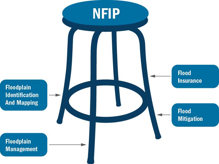
8 The National Flood Insurance Program A voluntary program based on a mutual agreement between the federal government and the local community In exchange for adopting & enforcing a Floodplain Management ordinance, federally-backed flood insurance is made available to property owners throughout the community The NFIP aims to reduce future flood damage by: Identifying flood risks (i.e. flood maps) Regulating floodplain development Providing insurance in participating communities.
9 NFIP Cont.

10 What is a Flood? NFIP Flood Definition: A general and temporary condition of partial or complete inundation of 2 or more acres of normally dry land or 2 or more adjacent properties
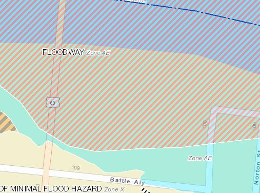
11 What is a Floodplain? A Floodplain is the low-lying area adjacent to a river or stream that is subject to periodic flooding. The Floodway carries the most water at the highest velocities. It is the most dangerous area during a flood.
12 Mapping
13 Flood Maps FEMA produced Flood Insurance Rate Maps (FIRMs) for all communities in the Commonwealth. KDOW is the CTP for Kentucky FIRMs show: The 1% or greater chance of flooding Base flood elevations (in AE zones only) Regulatory floodways May show community landmarks The SFHAs shown on the community FIRM are the areas where development is regulated at the State & Local levels
14 Flood Insurance Rate Map (FIRM) Old FIRMs New FIRMs
15 Flood Insurance Study (FIS) Provides technical data about the flood study Summary of Discharges, Flood Elevation Profiles, Floodway Data Tables Pertinent references for the flood study
16 Digital Flood Maps Multiple different digital services available Map Service Center NFHL Service KDOW Watermaps Will be covered later in this presentation
17 NFIP Requirements
18 Federal Requirements Regulating development with permits is a requirement of the NFIP 44 CFR 60.3(a)(1) Require permits for all proposed construction or other development in the community so that it may determine whether such construction or other development is proposed within flood-prone areas; All regulations in 60.3 (i.e. parts a through e) build on one another Section (a) also requires that all necessary permits are obtained and that all proposed development is reasonably safe from flooding.
19 KRS State Requirements No person, city, county or other political subdivision of the state shall [develop in] any area located adjacent to a river or stream or in the floodway of the stream unless plans and specifications for such work have been submitted to and approved by the cabinet and a permit issued as required

20 KY Floodplain Management Kentucky Division of Water (KDOW) Floodplain Management section Responsible for the approval or denial of proposed development in the 1% annual chance floodplain of all streams in the Commonwealth Development is broadly defined Typical activities permitted: Bridges, culverts, and low water crossings Residential & commercial buildings Fill, Stream alterations or relocations Small impoundments Water and wastewater treatment plants


21 Floodplain Requirements All building lowest floors must be elevated or protected to at or above the BFE Includes all utilities, mechanical equipment, and ductwork


22 Floodplain Requirements Cont. Fully enclosed areas below the lowest floor require a total net area of 1 square inch of vent space per square foot of enclosed area Minimum of 2 openings The bottom of the openings shall be no higher than 1 foot above grade
23 Floodplain Requirements Cont. In A zones (areas where no floodway is identified), proposed encroachments must not result in more than a 1 foot increase in Base Flood Elevation (BFE) In AE zones, nothing may be placed within an floodway that will cause any rise in BFE Applicant must hire a Professional Engineer to perform an engineering analysis showing No-Rise Engineer should complete a No-Rise Certificate
24 Floodplain Requirements Cont. Frankfort, KY


25 Floodplain Requirements Cont. RVs are allowed in floodplains with the following requirements: Must be self propelled or pulled with light weight truck Must be road worthy and fully licensed for highway use Must be on site for less than 180 consecutive days Attached to the site using quick disconnect utilities No permanent additions
26 Local Requirements
 Administrator duties Development")
27 Local Ordinances All communities participating in the NFIP have a local Flood Damage Prevention Ordinance (FDPO) Local FDPO includes: Authorization & Purpose Definitions Provisions (where it applies) Administrator duties Development Requirements

28 Local Responsibilities The authority to regulate floodplains is under the local jurisdiction. You are enforcing the local ordinance regulations, not FEMA s! This gives the local community the ability to adopt more stringent requirements in the SHFAs. Reduces community risk as a whole
29 Local FP Coordinator Duties Most community ordinances name the community CEO or their designee as the local coordinator Typical duties include: Make floodplain determinations Notify applicants of required permits Assist applicant with state floodplain application Once federal and state permits have been obtained, review local floodplain permit application A local permit should be Issued or denied based on the local application & the community s ordinance Inspect development (during and post construction) Ensure compliance/issue stop work orders Conduct additional inspections as needed Compile documentation for community records Plans, permits, maps, certificates


30 Floodplain Determinations Does this project qualify as development? Any manmade change to Real Estate Is this development in the floodplain? If yes, what is the maximum BFE at this site?


31 Floodplain Determinations Cont. FEMA Map Service Center Source for all public FEMA Flood Hazard products FIRMs, FISs, LOMCs, and Flood Risk Communication Products KDOW Flood Risk Portal A zone BFEs available for 119 of 120 counties Engineering reports and zone A models available as well
32 Local Permitting Procedure 1) Determine if project meets the definition of development in your community s ordinance 2) Floodplain Determination If YES, a state AND local floodplain permit is required If NO, no further action is needed 3) Determine what permit(s) are required. Obtain these first. USACE, KDOW floodplain, water quality, endangered species, etc. Provide guidance to applicant for applicable federal and state applications Floodplain maps -or- KY Water Health Portal Wetlands 4) Require local floodplain development application Provide guidance to applicant for local application 5) Issue Local Floodplain Permit based on application & ordinance Should be on community letterhead with CEO or the local floodplain coordinator s signature
 Freeboard, setbacks, etc. Structure s lowest floor Cost vs. Market Value Substantial?")
33 Local Permitting Basics Local permit applications are an NFIP requirement to ensure that development meets local ordinance requirements. Local ordinances may go above & beyond State requirements. Things to consider: Type of development Flood zone & Floodway Base Flood Elevation (BFE) Freeboard, setbacks, etc. Structure s lowest floor Cost vs. Market Value Substantial? A local permit must be issued in conjunction with State permit If not, State permit is null & void
34 Other Floodplain Stakeholders
 to have property removed from floodplain Lender may still require flood")
35 Lenders Lenders are required by law to ensure property owners have flood insurance with a federally backed mortgage Can require flood insurance at any time, regardless of flood zone Homeowner can request a Letter of Map Change (LOMC) to have property removed from floodplain Lender may still require flood insurance


36 Insurance Agents Agents will use the FIRM & basic information about the structure to rate the policy Best available data Agents tend to be conservative If an Elevation Certificate is available, it is always preferable Shows structures elevation in relation to BFE Allows for true risk rating An improperly located or constructed home will effect that structures policy rating


37 Construction Affects Insurance Top of Lowest Floor Freeboard BFE Flood Resistant Materials Flood Vents
38 Reduces Risk Citizens Not reliant only on Disaster Assistance Insurance available to everyone in an NFIP participating community Homeowners policies DON T cover flooding Residential or Renter policy Structure ($250K) Contents ($100K) Business Owner policy Structure ($500K) Contents ($500K)
39 Break Please be back in 10 minutes
40 Tips, Tricks, & Tools


41 Tools


42 Tools help inform citizens that a risk exists
43 FEMA Map Service Center Source for all public FEMA Flood Hazard products Flood Insurance Rate Maps (FIRMs) Flood Insurance Studies (FISs) Letters of Map Change (LOMCs) Risk MAP non-regulatory products Search by location (State, County, City, address, or Lat/Long.) to get the appropriate product
44 FEMA Map Service Center
45 Flood Insurance Rate Map (FIRM) Old FIRMs Newer FIRMs
46 Flood Insurance Study (FIS) Provides technical data about the flood study Summary of Discharges, Flood Elevation Profiles, Floodway Data Tables Pertinent references for the flood study

47 FIRM Panels FIRM Panels are the legal regulatory documents for floodplain management FIRM panels are usually 24 x 36 Not something the average user can easily print Also difficult for communities to make copies Can make providing a map difficult for communities and citizens during floodplain application

48 FIRMette Tool

49 National Flood Hazard Layer (NFHL) Designed to work with ArcMap projects and ArcMap Online Data not stored locally Automatically updates National source for All Digital FIRM layers LOMC locations & dates Links to download LOMCs Links to the effective panels DFIRM County GIS Data download FEMAs NFHL

50 KDOW Watermaps Risk MAP Portal Water Health Portal KY Watershed Viewer KDOW Story Map Gallery HAB Viewer Special Use Waters Draught Viewer FEMA Flood Map Project Update Map


51 Risk MAP Portal Statewide floodplains in a single map Displays the same floodplain as the FEMA GeoPlatform Map Zone A BFEs available 119 of 120 1% annual chance BFE determinations in the A Flood Zones with a simple click on the stream centerline Hydrologic & Hydraulic reports and models for A zones available for download FIS and Shapefiles also available Phase II and Beyond Hydraulic models and BFE determination available statewide Dam safety information


52 FEMA Flood Map Updates RiskMAP is in the process of revising the floodmaps for all watersheds in the Commonwealth Risk Mapping, Assessment, & Planning Not all FIRMs are updated during this process Three currently available for review Lower Cumberland Watershed Silver-Little Kentucky Watershed Jefferson County After maps complete the Due Process phase, communities are issued paper maps.


53 FEMA Flood Map Updates Cont. Effective Preliminary Preliminary maps for communities to review Not Regulatorily Effective Once maps become effective, maps are included on the RiskMAP Portal

54 FEMA Flood Map Updates Cont.
55 U.S. Geological Survey Flood Inundation Mapping The USGS Flood Inundation Mapping Program strives to help communities understand flood risks and make cost-effective mitigation decisions. The USGS works with the National Weather Service, U.S. Army Corps of Engineers, and the Federal Emergency Management Agency to ensure the quality and consistency of flood inundation maps nationwide. Inundation maps can be used for: Preparedness - "What-if" scenarios Timely Response - tied to real-time gage and forecast information Recovery - damage assessment Mitigation and Planning - flood risk analyses Environmental and Ecological Assessments - wetlands identification, hazardous spill cleanup Mobile Friendly -

56 Flood Inundation Mapper
 Kentucky located in the Ohio Region http://water.weather.")
57 National Weather Service AHPS Advanced Hydrologic Prediction Service (AHPS) Kentucky located in the Ohio Region


58 National Weather Service AHPS Individual Gage Data Hydrograph current & near future water level Probability Graph Chance of flooding over the next few months River at a Glance View multiple gages information on same page Gage Location Attribute Historic and recent crests
59 Mitigation

60 Mitigation is the effort to reduce loss of life and property by lessening the impact of disasters Mitigation can occur pre-, during, or postflood Funding sources to help communities and its citizens take mitigation actions Mitigation
 may be able to")
61 Mitigation Funding Cont. Hazard Mitigation Grant Program (HMGP) Help communities implement hazard mitigation measures following a disaster declaration. KY is an Enhanced state: 20% of disaster funds allocated for HMGP FEMA funds 75% Kentucky funds 12% Locals responsible for 13% **Department for Local Government (DLG) may be able to fund up to 75% of local share
 Provides funding to local communities for projects and")

62 Mitigation Funding Pre-Disaster Mitigation (PDM) Assisting local communities in implementing a pre-disaster natural hazard mitigation program Flood Mitigation Assistance (FMA) Provides funding to local communities for projects and planning that reduces or eliminates long-term risk of flood damage to structures insured under the NFIP. PDM & FMA are open annually and are nationally competitive State Hazard Mitigation Officer Geni Jo Brawner, KYEM geneva.j.brawner.nfg@mail.mil
63 Mitigation Funding Cont. Increased Cost of Compliance (ICC) ICC is a part of most standard flood insurance policies available under the NFIP Must have flood insurance, be in the floodplain, and be declared substantially damaged by the community Can provides up to $30,000 to help cover the cost of mitigation actions that help reduce flood risk DLGs Flood Control Matching Grant Program May help meet the local cost-share match requirements associated with mitigation projects.

 Wet floodproofing (e.")
64 Mitigation Funding Cont. HUD 203(K) Loan Program Traditional lending requires Loan-to-Value ratios that may prohibit financing of mitigation activities. 203K allows homeowners to finance the purchase plus the cost of its repairs through a single mortgage. Portion of loan pays off existing mortgage, and remaining funds put in escrow & released on project completion. Streamlined process available for repairs up to $35,000 Eligible Activities Structural elevation of the home above BFE Relocation of the home to a non-flood prone site Dry floodproofing (e.g., make structure water-tight) Wet floodproofing (e.g., installing flood vents) Relocating utilities and systems out of a basement, or elevating the utilities Overhead sewers and/or backflow prevention Structural alterations and reconstruction
65 Other Trainings
66 Other Trainings FEMA s Emergency Management Institute (EMI) E0273: Managing Floodplain Development thru the NFIP E0194: Advanced Floodplain Management Concepts E0278: NFIP / Community Rating System All are 4 day courses in Emmitsburg, Maryland FEMA will cover Transportation & Lodging costs Communities responsible only for $125 meal ticket EMI Independent Study (Distance Learning) IS-1100.a: Increased Cost of Compliance IS-1102: Theory of Elevation Rating IS-1103: Elevation Certificate for Surveyors IS-1105: EC Made Easy-Elevation Certificate Overview

67 Other Trainings Cont. KDOW will offer 1 EMI course in the coming months L0273: Managing Floodplain Development thru the NFIP Dates and Lactations have not been selected Contact NFIP Coordinator if you or someone from your community is interested in participating
68 Webinars Other Trainings Cont. CRS Resources KDOW & KYEM periodically offer webinars on flood and mitigation topics KAMM Regional Trainings Regional Trainings: March & April 2017 Spread throughout the state Beginner & Intermediate

69 DON T PANIC!
 782-7120 (Direct Line) Division of Water 300 Sower Blvd.")
70 Alex VanPelt, CFM Contact Info Kentucky NFIP Coordinator (502) (Direct Line) Division of Water 300 Sower Blvd., 3 rd Floor Frankfort, KY 40601

71 Questions
NFIP Program Basics. KAMM Regional Training
 NFIP Program Basics KAMM Regional Training Floodplain 101 Homeowners insurance does not cover flood damage Approximately 25,000 flood insurance policies in KY According to BW12 analysis, approximately
Interagency Nonstructural Flood Risk Management Workshop. Carey Johnson Kentucky Division of Water
 Interagency Nonstructural Flood Risk Management Workshop Carey Johnson Kentucky Division of Water Nonstructural Flood Risk Management Nonstructural floodproofing Elevation Relocation Buyout/acquisition
FREQUENTLY ASKED QUESTION ABOUT FLOODPLAINS Michigan Department of Environmental Quality
 FREQUENTLY ASKED QUESTION ABOUT FLOODPLAINS Michigan Department of Environmental Quality WHAT IS A FLOOD? The National Flood Insurance Program defines a flood as a general and temporary condition of partial
Floodplain Management 101. Mississippi Emergency Management Agency Floodplain Management Bureau
 Floodplain Management 101 Mississippi Emergency Management Agency Floodplain Management Bureau Stafford Act The Stafford Disaster Relief and Emergency Assistance Act (Stafford Act) (Public Law 100-707)
National Flood Insurance Program (NFIP) for Real Estate Professionals
 for Real Estate Professionals") National Flood Insurance Program (NFIP) for Real Estate Professionals 1 Joshua Oyer, CFM Outreach Specialist NFIP State Coordinator s Office at the Texas Water Development Board 2 Outline Introduction
National Flood Insurance Program (NFIP) for Real Estate Professionals 1 Joshua Oyer, CFM Outreach Specialist NFIP State Coordinator s Office at the Texas Water Development Board 2 Outline Introduction
Kentucky Division of Water Permitting Floodplain Overview and Considerations
 Kentucky Division of Water Permitting Floodplain Overview and Considerations Presentation to: 2014 KAMM Conference Lake Barkley State Resort Park by Solitha Dharman Department for Environmental Protection
FLOODPLAIN FAQ s. Last Update: June 2017
 FLOODPLAIN FAQ s Last Update: June 2017 What does FEMA stand for? Federal Emergency Management Agency - the operation of FEMA is to lead America to prepare for, prevent, respond to, and recover from disasters.
ASFPM Partnerships for Statewide Mitigation Actions. Alicia Williams GIS and HMP Section Manager, Amec Foster Wheeler June 2016
 ASFPM Partnerships for Statewide Mitigation Actions Alicia Williams GIS and HMP Section Manager, Amec Foster Wheeler June 2016 Summary The Concept Leveraging Existing Data and Partnerships to reduce risk
Floodplain Management 101: UNIT II. Maps & Flood Insurance Studies
 Floodplain Management 101: UNIT II Maps & Flood Insurance Studies Who is ASFPM? ASFPM stands for the Association of State Floodplain Managers A national organization of floodplain management professionals
The Future of Floodplain Management in Kentucky
 The Future of Floodplain Management in Kentucky Outline Background Federal Reauthorization Regulation Changes Insurance Changes Disclaimer All changes discussed in this presentation are PROPOSED ONLY.
LOCAL OFFICIALS MEETING Lake Wausau Physical Map Revision MARATHON COUNTY, WISCONSIN FEBRUARY 9, 2017
 LOCAL OFFICIALS MEETING Lake Wausau Physical Map Revision MARATHON COUNTY, WISCONSIN FEBRUARY 9, 2017 Welcome & Introduction Michelle Staff Floodplain Management Policy Coordinator, WDNR Michelle.Staff@Wisconsin.gov
Pre-Development Floodplain Application
 Pre-Development Floodplain Application The Department of Planning, at the recommendation of FEMA, is now requiring completion of a Pre- Development Floodplain Application for all properties in the regulated
Enough about me! Topics Covered
 About Me Worked in land surveying since 1997 Employed by the City of Orlando since 2006 City of Orlando City Surveyor since February 2015 Certified Floodplain Manager since 2015 Florida Licensed Surveyor,
Floodplain Development Permit Application
 Floodplain Development Permit Application **All construction will also require a building permit** This is an application packet for a Floodplain Development Permit. Certain sections are to be completed
Dealing With Unnumbered A Zones in Maine Floodplain Management
 Dealing With Unnumbered A Zones in Maine Floodplain Management The following is a list of acceptable methods that the State Floodplain Management Coordinator and the Federal Emergency Management Agency
ADVISORY BASE FLOOD ELEVATIONS (ABFEs)
") The Department of Homeland Security s Federal Emergency Management Agency is committed to helping communities that were impacted by Hurricanes Katrina and Rita rebuild safer and stronger. Following catastrophic
The Department of Homeland Security s Federal Emergency Management Agency is committed to helping communities that were impacted by Hurricanes Katrina and Rita rebuild safer and stronger. Following catastrophic
NFIP Overview Elevation Certificate Flood Insurance Rate Maps. By: Maureen O Shea, AICP, CFM State NFIP Coordinator
 NFIP Overview Elevation Certificate Flood Insurance Rate Maps By: Maureen O Shea, AICP, CFM State NFIP Coordinator Example of a flood failure Example of a flood failure Purposes of the NFIP Identify &
Kevin Wagner Maryland Department of the Environment
 Kevin Wagner Maryland Department of the Environment Topics Overview of the National Flood Insurance Program (NFIP) Mapping Regulations Insurance Mitigation Community Rating System (CRS) Questions Know
Door County Floodplain Program Informational Meeting
 Door County Floodplain Program Informational Meeting Door County Land Use Services Department Wisconsin Department of Natural Resources January 15, 2018 Floodplain = Land affected by flood event with a
Action Items for Flood Risk Management on Wildcat Creek Interagency success with floodplain management plans and flood forecast inundation maps
 Presentation to USACE 2012 Flood Risk Management and Silver Jackets Joint Workshop, Harrisburg, Pennsylvania Action Items for Flood Risk Management on Wildcat Creek Interagency success with floodplain
Table 1: Federal, State and Local Government Rules applicable to LOMRs/CLOMRS submittal
 MnDNR LOMC Guide This document has been prepared by the Minnesota Department of Natural Resources floodplain staff and is intended to provide assistance with LOMR/CLOMR submittals. This information is
Durham County Preliminary Flood Hazard Data Public Meeting. July 28, 2016
 Durham County Preliminary Flood Hazard Data Public Meeting July 28, 2016 Why Are We Here New flood hazard data has been released as Preliminary for Durham County Statutory Due Process for review/comments
What Was Updated in 2004 in Hennepin Countywide Maps?
 What Was Updated in 2004 in Hennepin Countywide Maps? Combined the city and township maps into one countywide index Done by USACE Mainly digital capture of old floodplain boundaries; some spots with shifts
Floodplain Development Permit Application
 Floodplain Development Permit Application City of Jonesboro, AR This is an application packet for a Floodplain Development Permit. Certain sections are to be completed by the Applicant, and certain sections
Bucks County, PA Flood Risk Review Meeting. November 2014
 Bucks County, PA Flood Risk Review Meeting November 2014 Agenda for Today Risk MAP Program overview Overview of non-regulatory Flood Risk Products and datasets Discuss mitigation action Technical overview
Article 23-6 FLOODPLAIN DISTRICT
 AMENDING THE CODE OF THE CITY OF PITTSFIELD CHAPTER 23, ZONING ORDINANCE SECTION I That the Code of the City of Pittsfield, Chapter 23, Article 23-6 Floodplain District, shall be replaced with the following:
Federal Emergency Management Agency
 Page 1 of 5 Issue Date: July 27, 2012 Effective Date: December 10, 2012 Case No.: 11-06-4512P Follows Conditional Case No.: 06-06-B789R LOMR-APP Federal Emergency Management Agency Washington, D.C. 20472
SECTION 9: MAPS AND DATA
 SECTION 9: MAPS AND DATA Contents 9.1. NFIP Maps and Data... 9-2 9.1.1. Adopting and enforcing NFIP floodplain maps and data... 9-2 9.1.2. Adopting and enforcing more restrictive data... 9-2 9.1.3. Annexations...
COLLIER COUNTY FLOODPLAIN MANAGEMENT
 COLLIER COUNTY FLOODPLAIN MANAGEMENT FREQUENTLY ASKED QUESTIONS The following information is based on common questions from the public. If you have a specific question or need further information, please
CRISP COUNTY, GEORGIA AND INCORPORATED AREAS
 CRISP COUNTY, GEORGIA AND INCORPORATED AREAS Community Name Community Number ARABI, CITY OF 130514 CORDELE, CITY OF 130214 CRISP COUNTY (UNINCORPORATED AREAS) 130504 Crisp County EFFECTIVE: SEPTEMBER 25,
Federal Emergency Management Agency
 Page 1 of 4 Issue Date: April 26, 2013 DETERMINATION DOCUMENT COMMUNITY AND REVISION INFORMATION PROJECT DESCRIPTION BASIS OF REQUEST City of Coppell Dallas County Texas FILL HYDRAULIC ANALYSIS NEW TOPOGRAPHIC
Floodplain Development Permits A Technical Guidance Document
 Floodplain Development Permits A Technical Guidance Document To Prevent Loss of Life, Reduce Property Damage and to Protect and Enhance the Natural and Beneficial Functions of Floodplains Iredell County
Requirements for Construction on Properties in the Special Flood Hazard Area (SFHA)
") Requirements for Construction on Properties in the Special Flood Hazard Area (SFHA) Rev 010915 The website for the IDNR to request the EFARA (Electronic Floodplain Analysis/Regulatory Assessment is found
Requirements for Construction on Properties in the Special Flood Hazard Area (SFHA) Rev 010915 The website for the IDNR to request the EFARA (Electronic Floodplain Analysis/Regulatory Assessment is found
Upper Joachim Creek Public Survey on Potential Flood Risk Reduction
 Upper Joachim Creek Public Survey on Potential Flood Risk Reduction This survey is intended to help the interagency planning committee to receive public feedback on specific flood risk reduction techniques,
California Building Code and the NFIP. John Ingargiola, Senior Engineer FEMA Building Science Branch
 California Building Code and the NFIP John Ingargiola, Senior Engineer FEMA Building Science Branch CA Major Disaster Declarations and Federal Assistance $21 $21 $76 $78 7 declarations, 2004-2016, total
INSTRUCTIONS FOR COMPLETING THE APPLICATION FORMS FOR CONDITIONAL LETTERS OF MAP REVISION AND LETTERS OF MAP REVISION
 INSTRUCTIONS FOR COMPLETING THE APPLICATION FORMS FOR CONDITIONAL LETTERS OF MAP REVISION AND LETTERS OF MAP REVISION GENERAL In 1968, the U.S. Congress passed the National Flood Insurance Act, which created
Preliminary DFIRM Community Coordination (PDCC) Meeting Gilchrist & Levy Counties, FL. April 30, 2015
 Meeting Gilchrist & Levy Counties, FL. April 30, 2015") Preliminary DFIRM Community Coordination (PDCC) Meeting Gilchrist & Levy Counties, FL April 30, 2015 Agenda 1. Introductions 2. Study Process and Timeline 3. Overview of Preliminary Products 4. Overview
Preliminary DFIRM Community Coordination (PDCC) Meeting Gilchrist & Levy Counties, FL April 30, 2015 Agenda 1. Introductions 2. Study Process and Timeline 3. Overview of Preliminary Products 4. Overview
Mitigation 101. KAMM Regional Training. February March Esther White, Speaker
 Mitigation 101 KAMM Regional Training February March 2014 Esther White, Speaker 1 2 Mitigation 101 Outline Intro to Mitigation Mitigation Grant Overview Benefit Cost Analysis (BCA) Methods CHAMPS Disasters
NFIP Mapping Issues. Wendy Lathrop, PLS, CFM. Cadastral Consulting, LLC
 NFIP Mapping Issues Cadastral Consulting, LLC NFIP Basic Objectives: Reduce the exposure to flood damages through the use of minimum standards for the placement and design of structures located in flood
AMENDMENTS TO CHAPTER 50: FLOODPLAIN DEVELOPMENT
 AMENDMENTS TO CHAPTER 50: FLOODPLAIN DEVELOPMENT PART I: 2018 FLOOD MAP IMPLEMENTATION PART II: STRATEGIES TO IMPROVE THE CITY S COMMUNITY RATING SYSTEM SCORE NATIONAL FLOOD INSURANCE PROGRAM (NFIP) CREATED
Key Fundamentals of Flood Insurance in the NFIP!
 a Welcome to Key Fundamentals of Flood Insurance in the NFIP! A Before and After approach for Housing Counselors Presented by: 1 Before the Flood Presenter Melanie Graham After the Flood Presenter Erin
Flood Plain Management Services (FPMS) Program
 Program") Flood Plain Management Services (FPMS) Program 2016 Winter Stakeholder Partnering Forum March 2016 Mario Beddingfield, P.E., CFM Hydraulic Engineer/FPMS Program Manager H&H/Water Control Branch U.S. Army
Flood Plain Management Services (FPMS) Program 2016 Winter Stakeholder Partnering Forum March 2016 Mario Beddingfield, P.E., CFM Hydraulic Engineer/FPMS Program Manager H&H/Water Control Branch U.S. Army
Repetitive Loss Area Revisit # 6 Walter Road Area Jefferson Parish
 Repetitive Loss Area Revisit # 6 Walter Road Area Jefferson Parish www.floodhelp.uno.edu Supported by FEMA Acknowledgement The compilation if this report was managed by Erin Patton, CFM, a UNO-CHART Research
Floodplain Management Annual Conference Atlanta, Georgia April 2017
 Floodplain Management 2017 Annual Conference Atlanta, Georgia April 2017 Floodplain Mapping and Flood Zones Zone Deisgnations: Zone A: No base flood elevations have been determined it is an approximated
Delaware River Basin Commission s Role in Flood Loss Reduction Efforts
 Delaware River Basin Commission s Role in Flood Loss Reduction Efforts There is a strong need to reduce flood vulnerability and damages in the Delaware River Basin. This paper presents the ongoing role
Skagit County Flood Insurance Study Update. Ryan Ike, CFM FEMA Region 10
 Skagit County Flood Insurance Study Update Ryan Ike, CFM FEMA Region 10 Skagit County Flood Insurance Study Process Overview Process, Schedule, & Deliverables Base Flood Elevations, Modeling, & Levees
DES MOINES CITY OF TWO RIVERS. Flooding Risk & Impact to Development
 DES MOINES CITY OF TWO RIVERS Flooding Risk & Impact to Development River System Des Moines Flood Protection Des Moines Flood Protection cont. Infrastructure Over 24 miles of levees 21stormwater pump stations
Community Rating System. National Flood Insurance Program
 National Flood Insurance Program Community Rating System A Local Official s Guide to Saving Lives Preventing Property Damage Reducing the Cost of Flood Insurance FEMA B-573 / May 2015 How the Community
Best Practices. for Incorporating Building Science Guidance into Community Risk MAP Implementation November 2012
 Best Practices for Incorporating Building Science Guidance into Community Risk MAP Implementation November 2012 Federal Emergency Management Agency Department of Homeland Security 500 C Street, SW Washington,
Federal Emergency Management Agency
 Page 1 of 4 Issue Date: September 7, 2012 Effective Date: January 22, 2013 DETERMINATION DOCUMENT COMMUNITY COMMUNITY AND REVISION INFORMATION City of Lubbock Lubbock County Texas PROJECT DESCRIPTION CHANNELIZATION
Levees: PL84-99 and the NFIP
 Levees: PL84-99 and the NFIP Tony D. Krause, P.E., CFM Flood Risk and Floodplain Management Omaha District US Army Corps of Engineers Objectives and Overview Objectives: Identify overlaps between Federal
Sources of FEMA Funding
 ASFPM Nonstructural/Floodproofing Workshops Sources of FEMA Funding ASFPM Nonstructural/Floodproofing Committee Gene Barr, CFM Principal Project Manager Nonstructural Specialist Sources of FEMA Funding
Kentucky Risk MAP It s not Map Mod II
 Kentucky Risk MAP It s not Map Mod II Risk Mapping Assessment and Planning Carey Johnson Kentucky Division of Water carey.johnson@ky.gov What is Risk MAP? Risk Mapping, Assessment, and Planning (Risk MAP)
Herkimer County, New York Flood Hazard Mapping Status Report for Property Owners
 Herkimer County, New York Flood Hazard Mapping Status Report for Property Owners Herkimer County, New York Flood Hazard Mapping Status Report for Property Owners FLOOD INSURANCE Who Should Purchase Flood
JAXGIS FEMA Flood Hazard Mapping -- Frequently Asked Questions
 Flood Hazard Zone Designations Summary Zones starting with the letter 'A' (for instance, Zone A, Zone AE, Zone AH, Zone AO) denote a Special Flood Hazard Area, which can also be thought of as the 100-year
Federal Emergency Management Agency
 Page 1 of 5 Issue Date: October 16, 2014 Effective Date: March 2, 2015 Case No.: 14-09-2279P LOMR-APP Federal Emergency Management Agency Washington, D.C. 20472 LETTER OF MAP REVISION DETERMINATION DOCUMENT
Chapter 7 Appendix B: National Flood Insurance Program Summary for Kaua'i County, 2015 Update
 Chapter 7 Appendix B: National Flood Insurance Program Summary for Kaua'i County, 2015 Update Topic Considerations Description INSURANCE SUMMARY STAFF RESOURCES How many NFIP policies are in Kaua i County?
This survey is expected to take approximately 20 minutes and must be completed in one session.
 Introduction Thank you for your willingness to participate in this online survey as part of the State Flood Assessment effort. This first step toward developing comprehensive flood planning for Texas does
Facts & Info regarding the NFIP in Mathews County VA And the Mathews County Floodplain Management Ordinance
 Facts & Info regarding the NFIP in Mathews County VA And the Mathews County Floodplain Management Ordinance As of 05-31-2014: Current NFIP policies in Mathews County = 1687 NFIP Claims= 1127, for a total
Cameron County, TX. Consultation Coordination Officer (CCO) Meeting. Please sign in (sheet at front of the room) Meeting will begin at 9:00
 Meeting. Please sign in (sheet at front of the room) Meeting will begin at 9:00") Cameron County, TX Consultation Coordination Officer (CCO) Meeting Please sign in (sheet at front of the room) Meeting will begin at 9:00 July 29, 2015 Lisa Jennings FEMA Region 6 Roles & Responsibilities
Cameron County, TX Consultation Coordination Officer (CCO) Meeting Please sign in (sheet at front of the room) Meeting will begin at 9:00 July 29, 2015 Lisa Jennings FEMA Region 6 Roles & Responsibilities
BUTTS COUNTY, GEORGIA AND INCORPORATED AREAS
 BUTTS COUNTY, GEORGIA AND INCORPORATED AREAS Butts County Community Name Community Number BUTTS COUNTY (UNICORPORATED AREAS) 130518 FLOVILLA, CITY OF 130283 JACKSON, CITY OF 130222 JENKINSBURG, TOWN OF
IN THIS ISSUE SPRING FLOODS. Black River, Pocahontas, Arkansas
 IN THIS ISSUE April and May brought a series of severe storm events to Arkansas, causing extensive damage throughout the state. ANRC spoke with many of you, gathering information on damages, providing
a) Ensure public safety through reducing the threats to life and personal injury.
 Ensure public safety through reducing the threats to life and personal injury.") SECTION VII: FLOODPLAIN DISTRICT 7-1 Statement Of Purpose The purposes of the Floodplain District are to: a) Ensure public safety through reducing the threats to life and personal injury. b) Eliminate
SECTION VII: FLOODPLAIN DISTRICT 7-1 Statement Of Purpose The purposes of the Floodplain District are to: a) Ensure public safety through reducing the threats to life and personal injury. b) Eliminate
Federal Emergency Management Agency
 Page 1 of 4 Issue Date: August 1, 2012 Effective Date: December 13, 2012 Case No.: 12-06-0595P LOMR-APP Washington, D.C. 20472 LETTER OF MAP REVISION DETERMINATION DOCUMENT COMMUNITY AND REVISION INFORMATION
This survey is expected to take approximately 20 minutes and must be completed in one session.
 State Flood Assessment Survey 1 Introduction Thank you for your willingness to participate in this online survey as part of the State Flood Assessment effort. This first step toward developing comprehensive
History of Floodplain Management in Ascension Parish
 History of Floodplain Management in Ascension Parish presented by: Kara Moree Floodplain Coordinator February 6, 2012 Floodplain 101 Floodplain 101 Base or 1% Flood: A flood having a 1% chance of being
Maryland Model Floodplain Management Ordinance (May, 2014) MODEL NOTES
 MODEL NOTES") Maryland Model Floodplain Management Ordinance (May, 2014) MODEL NOTES The model floodplain management ordinance that most Maryland communities have used as the basis for their regulations since the early
Maryland Model Floodplain Management Ordinance (May, 2014) MODEL NOTES The model floodplain management ordinance that most Maryland communities have used as the basis for their regulations since the early
FEMA s Flood Map Modernization Preparing for FY09 and Beyond: Integrated Flood Data Update, Risk Assessment, and Mitigation Planning
 FEMA s Flood Map Modernization Preparing for FY09 and Beyond: Integrated Flood Data Update, Risk Assessment, and Mitigation Planning DRAFT CONCEPT PAPER June 1, 2007 Integrated Flood Data Update, Risk
Michael Taylor, PE, CFM Project Manager, AECOM August 25, 2015
 Promoting FEMA s Flood Risk Products in the Lower Levisa Watershed Michael Taylor, PE, CFM Project Manager, AECOM August 25, 2015 Agenda Study Background Flood Risk Product Overview AOMI and Mitigation
Now forget it all for the next 90 minutes.
 Karol L. Grove, PS Get ready to think outside of the box. Get ready to think about surveying, flood zones and flood insurance in a whole new light.. Think about everything you think you know about Elevation
Oak Island 1999 Hurricane Floyd
 Oak Island 1999 Hurricane Floyd Topics to be Discussed What is a flood zone Flood zones in Oak Island Special Flood Hazard Areas (SFHA) Flood insurance Base Flood Elevations (BFEs) Building in flood zones
Chapter 6 - Floodplains
 Chapter 6 - Floodplains 6.1 Overview The goal of floodplain management is to reduce the potential risks to both existing and future developments, and infrastructure, in the 100-year floodplain. Over the
MT-1 Basics: A Comprehensive Overview of LOMAs and Discussion of Common Application Setbacks
 MT-1 Basics: A Comprehensive Overview of LOMAs and Discussion of Common Application Setbacks Introduction: Terminology MT-1s vs. MT-2s LOMAs vs. LOMRs What is a LOMC? Letters of Map Change (LOMCs) MT-1s
FLOOD INSURANCE. Introduction
 FLOOD INSURANCE Introduction The purpose of this course is to provide a comprehensive description of the NFIP for insurance producers who are seeking continuing education credits. It provides an overview
FLOODPLAIN DEVELOPMENT VARIANCE APPLICATION PACKET
 FLOODPLAIN DEVELOPMENT VARIANCE APPLICATION PACKET Sutter County Water Resources Department 1130 Civic Center Boulevard Yuba City, California, 95993 (530) 822-7400 Floodplain management regulations cannot
Federal Emergency Management Agency
 Page 1 of 6 Issue Date: October 24, 2012 Effective Date: March 7, 2013 Case No.: LOMR-APP DETERMINATION DOCUMENT COMMUNITY AND REVISION INFORMATION PROJECT DESCRIPTION BASIS OF REQUEST City of Lubbock
Using GISWeb to Determine Your Property s Flood Zone
 Using GISWeb to Determine Your Property s Flood Zone 1. In a new browser window, go to http://www.co.santacruz.ca.us/departments/geographicinformationsystemsgis.aspx 2. Click on GISWeb - GIS Mapping Application
North Carolina Department of Public Safety Emergency Management Risk Management
 North Carolina Department of Public Safety Emergency Management Risk Management Roy Cooper, Governor Erik A. Hooks, Secretary Michael A. Sprayberry, Director INSTRUCTIONS FOR COMPLETING THE NORTH CAROLINA
Federal Emergency Management Agency
 Page 1 of 4 Issue Date: October 2, 2017 Effective Date: October 2, 2017 Case No.: 17-09-2731P LOMR-APP Federal Emergency Management Agency Washington, D.C. 20472 LETTER OF MAP REVISION DETERMINATION DOCUMENT
Flood Risk Review (FRR) Meeting. Cumberland County, Pennsylvania Carlisle, Pennsylvania December 5, 2016
 Meeting. Cumberland County, Pennsylvania Carlisle, Pennsylvania December 5, 2016") Flood Risk Review (FRR) Meeting Cumberland County, Pennsylvania Carlisle, Pennsylvania December 5, 2016 Why are we here today? The Flood Insurance Study (FIS) report and Flood Insurance Rate Maps (FIRMs)
Flood Risk Review (FRR) Meeting Cumberland County, Pennsylvania Carlisle, Pennsylvania December 5, 2016 Why are we here today? The Flood Insurance Study (FIS) report and Flood Insurance Rate Maps (FIRMs)
FEMA s Non-Disaster Grant Programs
 FEMA s Non-Disaster Grant Programs KAMM Conference August 24, 2016 UK Hazard Mitigation Grants Program 1 Non-Disaster Grant Programs Pre-Disaster Mitigation (PDM) Flood Mitigation Assistance (FMA) 2 Non-Disaster
10526 Bermuda Isle Dr. Tampa, FL 33647
 Flood Analysis Memo Property Address In Partnership with: ** This property is NOT within a high-risk flood zone ** This property is located in a FEMA low-risk zone designated as Zone X - an area of minimal
Flood Risk in the Schuylkill Watershed. Planning for Resilient Communities
 Flood Risk in the Schuylkill Watershed Planning for Resilient Communities Welcome to Our Poster Session! We are here to talk about: Flood Risk in the Schuylkill River Watershed Taking Action to Reduce
Chapter 5 Floodplain Management
 Chapter 5 Floodplain Management Contents 1.0 Introduction... 1 2.0 Floodplain Management and Regulation... 1 2.1 City Code... 1 2.2 Floodplain Management... 1 2.3 Level of Flood Protection... 2 2.3.1 Standard
Updates to Maine Coastal Flood Insurance Rate Maps (FIRM s): What a Local Official Should Know. Presented by: Steve Johnson, P.E.
: What a Local Official Should Know. Presented by: Steve Johnson, P.E.") Updates to Maine Coastal Flood Insurance Rate Maps (FIRM s): What a Local Official Should Know Presented by: Steve Johnson, P.E. Town Engineer October 4, 2018 Introduction Federal Emergency Management
Updates to Maine Coastal Flood Insurance Rate Maps (FIRM s): What a Local Official Should Know Presented by: Steve Johnson, P.E. Town Engineer October 4, 2018 Introduction Federal Emergency Management
Federal Emergency Management Agency
 Page 1 of 5 Issue Date: June 21, 2013 Follows Conditional Case No.: 04-06-A148R DETERMINATION DOCUMENT COMMUNITY COMMUNITY AND REVISION INFORMATION City of Irving Dallas County Texas FILL PROJECT DESCRIPTION
Taylor County, Florida Community Coordination and Outreach (CCO) Meeting
 Meeting") Taylor County, Florida Community Coordination and Outreach (CCO) Meeting Suwannee River Water Management District April 26, 2017 11:00AM to 12:00PM Taylor County Administration Building, 201 E. Green Street,
Taylor County, Florida Community Coordination and Outreach (CCO) Meeting Suwannee River Water Management District April 26, 2017 11:00AM to 12:00PM Taylor County Administration Building, 201 E. Green Street,
Introduction to the National Flood Insurance Program: A Guide for Coastal Property Owners MAINE BEACHES CONFERENCE 2017
 Introduction to the National Flood Insurance Program: A Guide for Coastal Property Owners MAINE BEACHES CONFERENCE 2017 SUE BAKER, CFM STATE NFIP COORDINATOR MAINE DEPT OF AGRICULTURE, CONSERVATION & FORESTRY
Guideline For Compliance With The Standards and Criteria of the National Flood Insurance Program
 Guideline For Compliance With The Standards and Criteria of the National Flood Insurance Program 160-5-4-.16 (a) 1 Educational Facility Site, Construction, and Reimbursement Facilities Services Unit Effective
STATE OF MARYLAND FLOODPLAIN MANAGEMENT PLAN FIVE-YEAR WORK PLAN DRAFT SEPTEMBER, 2004
 STATE OF MARYLAND FLOODPLAIN MANAGEMENT PLAN FIVE-YEAR WORK PLAN DRAFT SEPTEMBER, 2004 Prepared by: Maryland Department of the Environment Wetlands and Waterways Program Flood Mitigation Division D R A
Federal Emergency Management Agency
 Page 1 of 6 Issue Date: September 27, 2010 Effective Date: February 14, 2011 Follows Conditional Case No.: 08-08-0873R DETERMINATION DOCUMENT COMMUNITY AND REVISION INFORMATION PROJECT DESCRIPTION BASIS
CHAPTER 15: FLOODPLAIN OVERLAY DISTRICT "FP"
 CHAPTER 15: FLOODPLAIN OVERLAY DISTRICT "FP" SECTION 15.1 STATUTORY AUTHORIZATION The legislature of the State of Minnesota in Minnesota Statutes, Chapter 103F and Chapter 394 has delegated the responsibility
WASHINGTON COUNTY, KENTUCKY AND INCORPORATED AREAS
 WASHINGTON COUNTY, KENTUCKY AND INCORPORATED AREAS COMMUNITY NAME COMMUNITY NUMBER *MACKVILLE, CITY OF 210475 SPRINGFIELD, CITY OF 210220 WASHINGTON COUNTY (UNINCORPORATED AREAS) 210365 *WILLISBURG, CITY
YOLO COUNTY FLOODPLAIN MANAGEMENT PROGRAM
 YOLO COUNTY FLOODPLAIN MANAGEMENT PROGRAM Answers to Commonly Asked Questions and A Guide for Residential Construction Within Special Flood Hazard Areas The automatic entry and exit of flood water); Or
WOOD COUNTY, WV FLOODPLAIN ORDINANCE TABLE OF CONTENTS
 WOOD COUNTY, WV FLOODPLAIN ORDINANCE TABLE OF CONTENTS ARTICLE I - GENERAL PROVISIONS 3 Section 1.1 Intent 3 Section 1.2 Abrogation and Greater Restrictions 3 Section 1.3 Applicability 3 Section 1.4 Matters
Floodplain Management. City Council Work Session April 16, 2013
 Floodplain Management City Council Work Session April 16, 2013 1 Discussion Agenda Flood Insurance Rate Changes Community Rating System Recommendation Floodplain Ordinance Enhancements Modifications Public
National Flood Insurance Program
 National Flood Insurance Program FEMA ELEVATION CERTIFICATES PA Surveyor Training Presented by Thomas F. Smith, PE, PLS January 22, 2018 1 FEMA Region III Mitigation Division Floodplain Management & Insurance
THE FEDERAL EMERGENCY MANAGEMENT AGENCY. Letters of Map Change Kristen Martinenza, P.E., CFM FEMA Region IV
 THE FEDERAL EMERGENCY MANAGEMENT AGENCY Letters of Map Change Presented by: Kristen Martinenza, P.E., CFM FEMA Region IV 1 NATIONAL FLOOD INSURANCE ACT OF 1968 At the start of the program, there was not
OTTAWA COUNTY FLOODPLAIN DEVELOPMENT PERMIT APPLICATION
 OTTAWA COUNTY FLOODPLAIN DEVELOPMENT PERMIT APPLICATION TO COMPLY WITH FLOODPLAIN MANAGEMENT REGULATIONS AND TO MINIMIZE POTENTIAL FLOOD DAMAGE, IF YOU ARE BUILDING WITHIN AN IDENTIFIED FLOOD HAZARD AREA,
The National Flood Insurance Program Community Rating System: An Introduction and Discussion of the RDO Role. October 2, :00-3:15 pm ET
 The National Flood Insurance Program Community Rating System: An Introduction and Discussion of the RDO Role October 2, 2014 2:00-3:15 pm ET Our Mission The National Association of Development Organizations