This survey is expected to take approximately 20 minutes and must be completed in one session.
|
|
|
- Amie Ford
- 6 years ago
- Views:
Transcription
1 State Flood Assessment Survey 1 Introduction Thank you for your willingness to participate in this online survey as part of the State Flood Assessment effort. This first step toward developing comprehensive flood planning for Texas does not seek to fund specific strategies or projects related to flood planning, mitigation, warning, or recovery. Instead, this effort seeks to obtain and communicate, via a statewide flood assessment report, the information that will determine the need for and benefits of statewide flood planning and financial investment. Your responses are intended to provide feedback on flood mitigation needs for your jurisdiction. Multiple surveys received from different respondents within the same community or jurisdiction can be submitted. There is no need to consolidate responses from your community. This survey is expected to take approximately 20 minutes and must be completed in one session. 1
2 State Flood Assessment Survey 1 Information About You 1. Which of the following best describes you? [Select only one.] I am the floodplain manager for a community participating in the National Flood Insurance Program (NFIP). I am a public-sector employee with flood-related responsibilities. I am an elected or appointed official with flood-related responsibilities. I am a person interested in the state flood assessment. 2. What type of entity do you represent? [Select only one.] Myself City Council of Governments County Special Purpose District River Authority State Tribe Federal 2
3 3. Does your community or jurisdiction participate in the Community Rating System program? Yes No 4. What is the name of your entity? [Can leave blank if representing yourself.] 5. What is your job title? [Can leave blank if representing yourself.] 6. In which county in Texas do you reside (if individual) or else in what county is your community located? 3
4 4
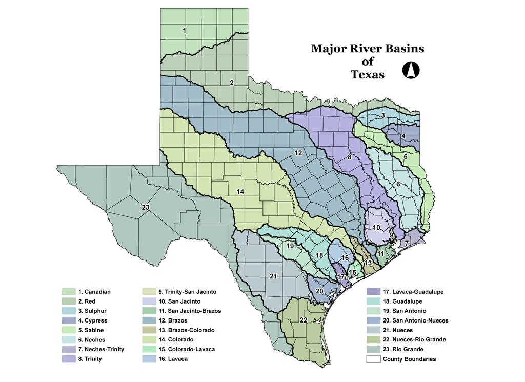
5 7. In which major river basin do you reside (if individual) or else in which river basin is your community located? [Select only one, see map above for reference.] Canadian Red Sulphur Cypress Sabine Neches Neches-Trinity Trinity Trinity-San Jacinto San Jacinto San Jacinto-Brazos Brazos Brazos-Colorado Colorado Colorado-Lavaca Lavaca Lavaca-Guadalupe Guadalupe San Antonio San Antonio-Nueces Nueces Nueces-Rio Grande Rio Grande 5
6 State Flood Assessment Survey 1 Flood Risk Information 8. How often does your community (or jurisdiction) experience each of these types of flood events? Never Very Rarely Rarely Occasionally Frequently Very Frequently I don't know Flash flooding Slow rise or downstream flooding Local flooding related to insufficient drainage Local flooding related to insufficient stormwater system capacity Coastal flooding from tropical storm system rainfall Coastal flooding from storm surge Structural dam failure flooding Structural levee breach flooding Other [please describe, including never, very rarely, etc.]: 6
7 9. Which of the following is used to define flood risk within your community or jurisdiction? [Select all that apply.] Flood Insurance Rate Maps (FIRMs) Locally created floodplain maps Master drainage plan Flood risk analysis (including hazard, performance, exposure, vulnerability, and consequence information) 10. With regard to flood risk maps, which of the following accurately describes your community? [Select all that apply.] Our maps depict riverine flooding but fail to capture low lying areas and streets sufficiently. We do not have enough area mapped. We have old, outdated maps. We lack the studies needed to create better flood risk maps. We recently updated our flood risk maps 7
8 State Flood Assessment Survey 1 Flood Management Activities 11. Which, if any, flood planning, mitigation, or protection activities has your community or jurisdiction implemented [Select all that apply]: Levees, flood walls, or related infrastructure Regional detention and/or retention basins Local detention and/or retention basins Local drainage improvements Local channel conveyance improvements Roadway bridges, culverts, and pipes Floodplain development ordinances Property buyouts or relocations Property elevation Reconstruction of noncompliant structures Flood-proofing and/or flood retrofits Flood awareness training and/or education Flood warning system Flood insurance (participation in the NFIP) I don't know 8
9 12. Which of the following describes your local funding sources for flood management activities? [Select all that apply.] General Fund Bond Program Storm Water Utility Fee Special Tax Districts Impact Fees Permitting Fees Ad Valorem Tax We do not have a local funding source for flood management activities 13. What is your community s or jurisdiction s estimated annual budget (local funds only) for flood management activities? [Select only one.] No local funds for flood management. Less than $100K $100K-500K $500K-1M $1M-5M $5M-10M $10M-30M Greater than $30M Specific Amount: 9
10 14. Regarding the local annual budget from the previous questions, approximately what percentage is allocated for the following flood management activities? If no local funds for flood management exist or you do not know the answer, please indicate as such in the box beside the choice for Other below. Operation and maintenance costs Flood hazard modeling and mapping Stream gages and early warning systems Flood-related infrastructure Public awareness/ outreach efforts Other [please describe, include percentage]: 10
11 15. In addition to local resources, if any, what other funding sources have you obtained to pay for implementation of your flood management activities? [Select all that apply.] Hazard Mitigation Grant Program (HMGP) [FEMA, TDEM] Pre-Disaster Mitigation (PDM) [FEMA, TDEM] Flood Mitigation Assistance (FMA) [FEMA, TWDB] U.S. Department of Agriculture - Natural Resources Conservation Service (NRCS) Community Development Block Grant-Disaster Recovery (CDBG-DR) [HUD, GLO] U.S. Army Corps of Engineers Small Continuing Authorities Program (USACE CAP) Cooperating Technical Partners program (CTP) [TWDB] State Water Implementation Fund for Texas (SWIFT) [TWDB] Flood Protection Planning Grant [TWDB] Texas Water Development Fund (DFund) [TWDB] Clean Water State Revolving Fund (CWSRF) [TWDB] 11
12 16. Which, if any, flood planning, mitigation, or protection activities has your community or jurisdiction identified as needed but not yet implemented? [Select all that apply.] Levees, flood walls, or related infrastructure Regional detention and/or retention basins Local detention and/or retention basins Local drainage improvements Local channel conveyance improvements Roadway bridges, culverts, and pipes Floodplain development ordinances Property buyouts or relocations Property elevation and/or flood-proofing Flood awareness training and/or education Flood warning system Flood insurance (participation in the NFIP) 12
13 17. Regarding your selections in the question above, what is the estimated total cost (regardless of funding source) to implement those needed activities? [Select only one.] Less than $1M $1M-25M $25M-50M $50M-100M $100M-500M $500M-1B Greater than $1B Specific Amount: 18. Regarding your answer above, what percentage of that total cost for needed activities would require outside (non-local) funding? 13
 90/10 cost chare (local share = 10%) 0% interest loan Subsidized loan Market rate loan State participation in projects through temporary")
14 19. Which of the following types of financial assistance for flood management projects might your community or jurisdiction pursue? [Select all that apply.] 50/50 cost share 75/25 cost share (local share = 25%) 90/10 cost chare (local share = 10%) 0% interest loan Subsidized loan Market rate loan State participation in projects through temporary ownership 20. Does your community or jurisdiction currently have a revenue stream to repay financial assistance for flood management activities in the form of a loan? Yes No 14
15 State Flood Assessment Survey 1 Additional Flood Topics 21. My community or jurisdiction would most benefit from more state resources directed at [Select up to 3]: Flood hazard mapping Flood modeling Central depository of online data Stream gages Financial assistance for flood mitigation planning Financial assistance for flood early warning systems Financial assistance for implementation of flood mitigation projects Flood emergency response Public awareness efforts Technical assistance 22. Does your community or jurisdiction currently work with other entities in your region to address flood risk and mitigation? [Select only one.] Yes No No, but we would benefit from regional collaboration 15
 A regional flood-focused effort (based on watershed boundaries and conducted by regional flood planning groups)")
16 23. If the state of Texas decides to pursue flood planning, should it be: [Select only one.] Like this flood assessment effort (a statewide compilation of existing information) A regional flood-focused effort (based on watershed boundaries and conducted by regional flood planning groups) Something else [please describe]: 24. If a state flood plan were created at some point in the future, what should be the purpose or goal of the plan? What should be included to meet that goal? 16
17 State Flood Assessment Survey 1 Conclusion 25. Do you have any other thoughts to share on the State Flood Assessment at this time? 26. A secondary survey will launch later this month and will include further discussion on topics such as opportunities to improve leveraging of existing funds, proactive solutions to improve flood resilience, and exploring the future of flood planning in Texas. Would you be interested in taking the follow-up survey? No, I would not. Yes, please me at the following address: Thank you very much for taking the time to complete this survey. Your input is key to the success of this effort to create the first State Flood Assessment. 17
This survey is expected to take approximately 20 minutes and must be completed in one session.
 Introduction Thank you for your willingness to participate in this online survey as part of the State Flood Assessment effort. This first step toward developing comprehensive flood planning for Texas does
10/5/2015. What Makes a Sound Floodplain Management Program? What are the Flood Problems in your Community?
 The Community Rating System (CRS) and Hazard Mitigation Planning Preparing Your Community Through Common Program Goals September 3, 2015 What Makes a Sound Floodplain Management Program? Know your community
Flood Mitigation Planning at the Texas Water Development Board. Josh Oyer, CFM December 7, 2016
 Flood Mitigation Planning at the Texas Water Development Board Josh Oyer, CFM December 7, 2016 1 Topics TWDB Flood Mitigation Planning overview NFIP Community Assistance Program Federal and State Grants
ADVISORY BASE FLOOD ELEVATIONS (ABFEs)
") The Department of Homeland Security s Federal Emergency Management Agency is committed to helping communities that were impacted by Hurricanes Katrina and Rita rebuild safer and stronger. Following catastrophic
The Department of Homeland Security s Federal Emergency Management Agency is committed to helping communities that were impacted by Hurricanes Katrina and Rita rebuild safer and stronger. Following catastrophic
A Flood Mitigation Plan for the Non-Tidal N.J. Section of the Delaware River Basin. Warren County Planning Workshop (2 nd Meeting) March 7, 2007
 March 7, 2007") A Flood Mitigation Plan for the Non-Tidal N.J. Section of the Delaware River Basin Warren County Planning Workshop (2 nd Meeting) March 7, 2007 Study Area Participation: Hunterdon: 16 Eligible Municipalities
A Flood Mitigation Plan for the Non-Tidal N.J. Section of the Delaware River Basin Warren County Planning Workshop (2 nd Meeting) March 7, 2007 Study Area Participation: Hunterdon: 16 Eligible Municipalities
ASFPM Partnerships for Statewide Mitigation Actions. Alicia Williams GIS and HMP Section Manager, Amec Foster Wheeler June 2016
 ASFPM Partnerships for Statewide Mitigation Actions Alicia Williams GIS and HMP Section Manager, Amec Foster Wheeler June 2016 Summary The Concept Leveraging Existing Data and Partnerships to reduce risk
Action Items for Flood Risk Management on Wildcat Creek Interagency success with floodplain management plans and flood forecast inundation maps
 Presentation to USACE 2012 Flood Risk Management and Silver Jackets Joint Workshop, Harrisburg, Pennsylvania Action Items for Flood Risk Management on Wildcat Creek Interagency success with floodplain
Hazard Mitigation Overview
 Hazard Mitigation Overview Yahara Lakes Advisory Group April 28, 2011 1 Discussion Topics Recent flood losses and damages Hazard mitigation programs Project opportunities 2 Recent Flood Losses* Date May
Hazard Mitigation Grants. Technical Assistance Session Middlesex County, NJ December 7, 2011
 Hazard Mitigation Grants Technical Assistance Session Middlesex County, NJ December 7, 2011 Outline Purpose of Hazard Mitigation Hazard Mitigation Projects Hazard Mitigation Assistance Grant Programs Using
A Little Less Conversation a Little More ACTION! Louie Greenwell, GISP, CFM T&M Associates Carey Johnson KY Division of Water
 A Little Less Conversation a Little More ACTION! Louie Greenwell, GISP, CFM T&M Associates Carey Johnson KY Division of Water Topics Covered It s all about ACTION! Kentucky s plan for delivering actions
Interagency Nonstructural Flood Risk Management Workshop. Carey Johnson Kentucky Division of Water
 Interagency Nonstructural Flood Risk Management Workshop Carey Johnson Kentucky Division of Water Nonstructural Flood Risk Management Nonstructural floodproofing Elevation Relocation Buyout/acquisition
Community Resilience & NFIP s Community Rating system
 Community Resilience & NFIP s Community Rating system Ajita Atreya Wharton Risk Management and Decision Processes Center University of Pennsylvania National Association of Counties (NACo) Session on Risk
Michael Taylor, PE, CFM Project Manager, AECOM August 25, 2015
 Promoting FEMA s Flood Risk Products in the Lower Levisa Watershed Michael Taylor, PE, CFM Project Manager, AECOM August 25, 2015 Agenda Study Background Flood Risk Product Overview AOMI and Mitigation
Delaware River Basin Commission s Role in Flood Loss Reduction Efforts
 Delaware River Basin Commission s Role in Flood Loss Reduction Efforts There is a strong need to reduce flood vulnerability and damages in the Delaware River Basin. This paper presents the ongoing role
Modernization, FEMA is Recognizing the connection between damage reduction and
 EXECUTIVE SUMMARY Every year, devastating floods impact the Nation by taking lives and damaging homes, businesses, public infrastructure, and other property. This damage could be reduced significantly
Flood Plain Management Services (FPMS) Program
 Program") Flood Plain Management Services (FPMS) Program 2016 Winter Stakeholder Partnering Forum March 2016 Mario Beddingfield, P.E., CFM Hydraulic Engineer/FPMS Program Manager H&H/Water Control Branch U.S. Army
Flood Plain Management Services (FPMS) Program 2016 Winter Stakeholder Partnering Forum March 2016 Mario Beddingfield, P.E., CFM Hydraulic Engineer/FPMS Program Manager H&H/Water Control Branch U.S. Army
CITY OF PLANTATION ENGINEERING DEPARTMENT INTEROFFICE MEMORANDUM NO
 CITY OF PLANTATION ENGINEERING DEPARTMENT INTEROFFICE MEMORANDUM NO. 2013-003 DATE: October 22, 2012 TO: Mayor and Members of City Council FROM: Brett W. Butler, PE, CFM City Engineer SUBJECT: CRS Program
Cameron County, TX. Consultation Coordination Officer (CCO) Meeting. Please sign in (sheet at front of the room) Meeting will begin at 9:00
 Meeting. Please sign in (sheet at front of the room) Meeting will begin at 9:00") Cameron County, TX Consultation Coordination Officer (CCO) Meeting Please sign in (sheet at front of the room) Meeting will begin at 9:00 July 29, 2015 Lisa Jennings FEMA Region 6 Roles & Responsibilities
Cameron County, TX Consultation Coordination Officer (CCO) Meeting Please sign in (sheet at front of the room) Meeting will begin at 9:00 July 29, 2015 Lisa Jennings FEMA Region 6 Roles & Responsibilities
BACKGROUND ANNUAL PROGRESS REPORT DEVELOPMENT ADOPTION OF THE H-GAC HAZARD MITIGATION PLAN/UPDATES MISSION STATEMENT
 BACKGROUND CITY OF CONROE FLOODPLAIN MANAGEMENT ANNUAL PROGRESS Activity 510 of the National Flood Insurance Program s (NFIP) Community Rating System (CRS) requires the development of a Floodplain Management
Role of Disaster Insurance in Improving Resilience: An Expert Meeting The Resilient America Roundtable
 Role of Disaster Insurance in Improving Resilience: An Expert Meeting The Resilient America Roundtable National Academy of Science Washington, DC July 9, 2015 Roseville Demographics Primary population
Passaic River Basin Flood Advisory Commission Report/Status of Recommendations. October 2014 Update
 Passaic River Basin Flood Advisory Commission Report/Status of Recommendations October 2014 Update Passaic River Basin Flood Advisory Commission April 2010: By Executive Order, Governor Christie created
Floodplain Management Plan
 Floodplain Management Plan CITY OF FORT WORTH TFMA 2016 Spring Conference March 10, 2016 Agenda 1. Fort Worth Higher Standards (NFIP & CRS) 2. Floodplain Management Plan Overview and Results 3. Project
State Flood Assessment
 State Flood Assessment Report to the Legislature 86th Legislative Session State Flood Assessment Report to the 86th Texas Legislature Peter M. Lake, Chairman Kathleen Jackson, Member Brooke T. Paup, Member
SECTION V THE LOCAL MITIGATION STRATEGY BLUEPRINT
 SECTION V THE LOCAL MITIGATION STRATEGY BLUEPRINT A. GUIDING MITIGATION PRINCIPLES The Local Mitigation Strategy (LMS) is Hillsborough County s program developed to reduce or eliminate all forms of losses
MUNICIPAL LAND USE STRATEGIES for Improving Flood Resilience
 MUNICIPAL LAND USE STRATEGIES for Improving Flood Resilience Strategy for a Flood Resistant Southern Tier Central Region (LWRP project) This presentation was prepared by Southern Tier Central Regional
GAFM Showcase: Multiple Agencies Combating Georgia s Flood Risk Together: Proven Results Gained by Strong Partnerships
 National Flood Insurance Program Participation GAFM Showcase: Multiple Agencies Combating Georgia s Flood Risk Together: Proven Results Gained by Strong Partnerships Moderator: Jill Bazinet, PE, CFM GAFM
FREQUENTLY ASKED QUESTION ABOUT FLOODPLAINS Michigan Department of Environmental Quality
 FREQUENTLY ASKED QUESTION ABOUT FLOODPLAINS Michigan Department of Environmental Quality WHAT IS A FLOOD? The National Flood Insurance Program defines a flood as a general and temporary condition of partial
Frequently Asked Questions (FAQs)
") FLOODS Floods are one of the most common hazards in the United States. Flood effects can be local, impacting a neighborhood or community, or very large, affecting entire river basins and multiple states.
FLOODS Floods are one of the most common hazards in the United States. Flood effects can be local, impacting a neighborhood or community, or very large, affecting entire river basins and multiple states.
7. Understand effect of multiple annual exposures e.g., 30-yr period and multiple independent locations yr event over 30 years 3%
 I. FLOOD HAZARD A. Definition 1. Hazard: probability of water height 2. At a Specific XY floodplain location; 3. Z can be expressed as elevation (NAVD88); gauge height; height above ground (depth). 4.
FEMA FLOOD MAPS Public Works Department Stormwater Management Division March 6, 2018
 FEMA FLOOD MAPS Public Works Department Stormwater Management Division March 6, 2018 Presentation Overview FEMA National Flood Insurance Program (NFIP) FEMA Community Rating System (CRS) Flood Insurance
HAZARD MITIGATION PLAN POINT OF CONTACT. MUNICIPAL PROFILE
 HAZARD MITIGATION PLAN POINT OF CONTACT troseberry@easton-pa.gov cmanges@easton-pa.gov MUNICIPAL PROFILE MUNICIPAL PARTICIPATION Compliance with the National Flood Insurance Program (NFIP) Identify source
Disaster Insurance: Are States and Insurance Companies Prepared?
 Disaster Insurance: Are States and Insurance Companies Prepared? National Conference of State Legislatures 2015 Legislative Summit Roy Wright Deputy Associate Administrator for Insurance and Mitigation
Flood Risk Outreach Tools for Georgia Communities. GAFM 10 th Annual Conference Presented By: Jarrett Mattli
 Flood Risk Outreach Tools for Georgia Communities GAFM 10 th Annual Conference Presented By: Jarrett Mattli April 13, 2016 Presentation Overview Guidebooks Toolkits Templates Educational Videos Resource
Volusia County Floodplain Management Plan 2012
 Volusia County Floodplain Management Plan 2012 Introduction The National Flood Insurance Program (NFIP) provides federally supported flood insurance in communities that regulate development in floodplains.
Justification for Floodplain Regulatory Standards in Illinois
 Justification for Floodplain Regulatory Standards in Illinois Office of Water Resources Issue Paper April, 2015 Proactive Illinois floodplain and floodway regulatory standards have prevented billions of
Community Rating System. National Flood Insurance Program
 National Flood Insurance Program Community Rating System A Local Official s Guide to Saving Lives Preventing Property Damage Reducing the Cost of Flood Insurance FEMA B-573 / May 2015 How the Community
Public Meeting Impact of Hurricane Irma on Central Beach
 Public Meeting Impact of Hurricane Irma on Central Beach CITY OF NEW SMYRNA BEACH October 11, 2017 at 6:00 pm Presentation Outline Hurricane Irma Impacts Flooding Caused by Hurricane Irma Original Goals
HAZARD MITIGATION PLAN POINT OF CONTACT MUNICIPAL PROFILE
 HAZARD MITIGATION PLAN POINT OF CONTACT louise@windgap-pa.gov jeffreyyob@gmail.com MUNICIPAL PROFILE MUNICIPAL PARTICIPATION Compliance with the National Flood Insurance Program (NFIP) Identify source
HAZARD MITIGATION PLAN POINT OF CONTACT MUNICIPAL PROFILE
 HAZARD MITIGATION PLAN POINT OF CONTACT hankvb@entermail.net khorvath@kceinc.com MUNICIPAL PROFILE MUNICIPAL PARTICIPATION Compliance with the National Flood Insurance Program (NFIP) Topic 1. Staff Resources
Third Appropriation Funding Recommendation
 Third Appropriation Funding Recommendation Context: It is currently anticipated but not confirmed that the State of Louisiana will receive an additional 51,435,000 allocation from the Department of Housing
Section 19: Basin-Wide Mitigation Action Plans
 Section 19: Basin-Wide Mitigation Action Plans Contents Introduction...19-1 Texas Colorado River Floodplain Coalition Mitigation Actions...19-2 Mitigation Actions...19-9 Introduction This Mitigation Plan,
Use of FEMA Non regulatory Flood Risk Products in Planning
 Use of FEMA Non regulatory Flood Risk Products in Planning Georgia Association of Floodplain Managers Annual Conference March 24, 2016 What are the Non regulatory Flood Risk products? Go beyond the basic
*How Federal Policy. Causes Flood Disasters. Leslie A. Bond, CFM LA Bond Associates
 *How Federal Policy Causes Flood Disasters Leslie A. Bond, CFM LA Bond Associates *The high cost of flood disasters *We do not know what floods cost. *Published estimates do not include all costs of disasters.
Flood-Risk Reduction and Resilience: Federal Assistance and Programs
 Flood-Risk Reduction and Resilience: Federal Assistance and Programs Nicole T. Carter Specialist in Natural Resources Policy Diane P. Horn Analyst in Flood Insurance and Emergency Management Jared T. Brown
FEMA s Flood Map Modernization Preparing for FY09 and Beyond: Integrated Flood Data Update, Risk Assessment, and Mitigation Planning
 FEMA s Flood Map Modernization Preparing for FY09 and Beyond: Integrated Flood Data Update, Risk Assessment, and Mitigation Planning DRAFT CONCEPT PAPER June 1, 2007 Integrated Flood Data Update, Risk
What are the savings? An Assessment of the National Flood Insurance Program s (NFIP) Community Rating System (CRS)
 Community Rating System (CRS)") What are the savings? An Assessment of the National Flood Insurance Program s (NFIP) Community Rating System (CRS) Ajita Atreya Postdoctoral Research Fellow Wharton Risk Management and Decision Processes
What are the savings? An Assessment of the National Flood Insurance Program s (NFIP) Community Rating System (CRS) Ajita Atreya Postdoctoral Research Fellow Wharton Risk Management and Decision Processes
National Disaster Mitigation Program NDMP Overview, Ontario Projects, and Final Call for Proposals
 National Disaster Mitigation Program NDMP Overview, Ontario Projects, and Final Call for Proposals March 6, 2018 NDMP Overview The NDMP is a 5-year federal program that set out $183 million for flood mitigation
Silver Jackets - Flood Risk Management Program
 COOPERATING TECHNICAL PARTNER INFORMATION EXCHANGE Silver Jackets - Flood Risk Management Program August 31, 2017 Association of State Floodplain Managers AUDIO AND WEB SETTINGS Your Participation Open
RECOVERY UPDATE: M i c h a e l A. S p r a y b e r r y D i r e c t o r, E m e r g e n c y M a n a g e m e n t
 M i c h a e l A. S p r a y b e r r y D i r e c t o r, E m e r g e n c y M a n a g e m e n t RECOVERY UPDATE: HOUSE SELECT COMMITTEE ON DISASTER RELIEF R E P A Y. R E P A I R. R E P L A C E. R E C O N S
Cumberland County, NJ. Risk MAP Project Status Update April 22, 2013
 Cumberland County, NJ Risk MAP Project Status Update April 22, 2013 Agenda Project Team Milestones Risk MAP Overview Study Scope overview Regulatory products Non-regulatory products Proposed Schedule Risk
Flood Risk Report. Guadalupe Blanco River Basin. October 2016
 Flood Risk Report Guadalupe Blanco River Basin Upper Guadalupe, Middle Guadalupe, San Marcos, and Lower Guadalupe (HUC8s 12100201-12100204) October 2016 [Type here] [Type here] [Type here] Flood Risk Report
Erie County Flood Risk Review Meeting. January 18, 2018
 Erie County Flood Risk Review Meeting January 18, 2018 Agenda The value of updated flood maps for your community Review updated flood-risk data and important next steps in the Risk MAP process Increasing
Natural Hazards Mitigation Plan. Executive Summary
 Natural Hazards Mitigation Plan Executive Summary 1. Introduction Kane County Illinois, is subject to natural hazards that threaten life and health and have caused extensive property damage. Floods struck
HAZARD MITIGATION PLAN POINT OF CONTACT MUNICIPAL PROFILE
 HAZARD MITIGATION PLAN POINT OF CONTACT nazareth50em1@gmail.com jessicagteel@gmail.com MUNICIPAL PROFILE MUNICIPAL PARTICIPATION 3. Describe how the public will be engaged in the current planning process
ASFPM RECOMMENDED TASK FORCE ACTIONS
 Association of State Floodplain Managers, Inc. 2809 Fish Hatchery Road, Suite 204, Madison, WI 53713 Phone: 608-274-0123 Fax: 608-274-0696 Website: www.floods.org Email: asfpm@floods.org Federal Interagency
HAZARD MITIGATION PLAN POINT OF CONTACT MUNICIPAL PROFILE
 HAZARD MITIGATION PLAN POINT OF CONTACT assistmanager@lowermilford.net publicworks@lowermilford.org MUNICIPAL PROFILE MUNICIPAL PARTICIPATION Compliance with the National Flood Insurance Program (NFIP)
A Flood Mitigation Plan for the Non-Tidal N.J. Section of the Delaware River Basin. Mercer County Kick-off Meeting December 6, 2006
 A Flood Mitigation Plan for the Non-Tidal N.J. Section of the Delaware River Basin Mercer County Kick-off Meeting December 6, 2006 The Delaware River. crosses many boundaries Four states: DE, PA, NJ, NY
National Flood Risk Management Program
 National Flood Risk Management Program US Army Corps of Engineers Floodplain Managers Association Sacramento, California July 29, 2010 Judy Soutiere Institute for Water Resources A Shared Responsibility
Flood Hazards and Flood Risk, the Impact of a Changing Climate
 Flood Hazards and Flood Risk, the Impact of a Changing Climate Sally A. McConkey, P.E. CFM, D. WRE. Illinois State Water Survey June 14, 2017 Topics ISWS Coordinated Hazard Assessment and Mapping Program
Kentucky Risk MAP It s not Map Mod II
 Kentucky Risk MAP It s not Map Mod II Risk Mapping Assessment and Planning Carey Johnson Kentucky Division of Water carey.johnson@ky.gov What is Risk MAP? Risk Mapping, Assessment, and Planning (Risk MAP)
New Jersey Department of Environmental Protection. Five-Year Floodplain Management Work Plan
 New Jersey Department of Environmental Protection Five-Year Floodplain Management Work Plan September 30, 2004 I. State Authority New Jersey Department of Environmental Protection Five-Year Floodplain
HAZARD MITIGATION PLAN POINT OF CONTACT MUNICIPAL PROFILE
 HAZARD MITIGATION PLAN POINT OF CONTACT lee.laubach@allentownpa.gov james.wehr@allentownpa.gov MUNICIPAL PROFILE MUNICIPAL PARTICIPATION Compliance with the National Flood Insurance Program (NFIP) 1. Staff
HAZARD MITIGATION PLAN POINT OF CONTACT MUNICIPAL PROFILE
 HAZARD MITIGATION PLAN POINT OF CONTACT northcatasauquaema@yahoo.com scheirerg@gmail.com MUNICIPAL PROFILE MUNICIPAL PARTICIPATION Compliance with the National Flood Insurance Program (NFIP) Identify source
SILVER JACKETS: TEAMING TO MITIGATE AND MANAGE STATE FLOOD HAZARD PRIORITIES
 SILVER JACKETS: TEAMING TO MITIGATE AND MANAGE STATE FLOOD 255 255 255 237 237 237 0 0 0 217 217 217 163 163 163 200 200 200 131 132 122 239 65 53 80 119 27 HAZARD PRIORITIES 110 135 120 252 174.59 112
ENGINEERING AND CONSTRUCTION BULLETIN
 ENGINEERING AND CONSTRUCTION BULLETIN No. 2016-8 Issuing Office: CECW-CE Issued: 22 Feb 16 Expires: 22 Feb 18 SUBJECT: Interim Risk Reduction Measures (IRRMs) for Levee Safety CATEGORY: Directive and Policy
Discovery Meeting: Middle Potomac- Catoctin Watershed. FEMA REGION III September 26, 2012 Rockville, MD and Fairfax, VA
 Discovery Meeting: Middle Potomac- Catoctin Watershed FEMA REGION III September 26, 2012 Rockville, MD and Fairfax, VA Agenda Introductions Purpose of This Meeting Discovery Process Community Rating System
DES MOINES CITY OF TWO RIVERS. Flooding Risk & Impact to Development
 DES MOINES CITY OF TWO RIVERS Flooding Risk & Impact to Development River System Des Moines Flood Protection Des Moines Flood Protection cont. Infrastructure Over 24 miles of levees 21stormwater pump stations
Dade County Natural Hazard Mitigation Plan
 Introduction to Mitigation Definition of Mitigation Mitigation is defined by FEMA as "...sustained action that reduces or eliminates longterm risk to people and property from natural hazards and their
HAZARD MITIGATION PLAN POINT OF CONTACT MUNICIPAL PROFILE
 HAZARD MITIGATION PLAN POINT OF CONTACT glendonboro@rcn.com glendonboro@rcn.com MUNICIPAL PROFILE MUNICIPAL PARTICIPATION Identify source of information, if different Topic from the one listed 1. Staff
Floodplain Management 101. Mississippi Emergency Management Agency Floodplain Management Bureau
 Floodplain Management 101 Mississippi Emergency Management Agency Floodplain Management Bureau Stafford Act The Stafford Disaster Relief and Emergency Assistance Act (Stafford Act) (Public Law 100-707)
Upper Joachim Creek Public Survey on Potential Flood Risk Reduction
 Upper Joachim Creek Public Survey on Potential Flood Risk Reduction This survey is intended to help the interagency planning committee to receive public feedback on specific flood risk reduction techniques,
Federal Flood Risk Management Standards. An Update on Federal Flood Resilience Standards
 Federal Flood Risk Management Standards An Update on Federal Flood Resilience Standards Purpose of Today s Briefing Facilitate the understanding of Executive Order (E.O.)13690 and its implementation Discuss
SUBJECT: EXECUTIVE DIRECTOR'S REPORT FOR JANUARY 19, 2017 WATER INFRASTRUCTURE IMPROVEMENTS FOR THE NATION (WIIN) ACT
 ACT") ITEM 2 Agenda of January 19, 2017 TO: FROM: Board of Directors Sacramento Area Flood Control Agency Richard M. Johnson, Executive Director (916) 874-7606 SUBJECT: EXECUTIVE DIRECTOR'S REPORT FOR JANUARY
ITEM 2 Agenda of January 19, 2017 TO: FROM: Board of Directors Sacramento Area Flood Control Agency Richard M. Johnson, Executive Director (916) 874-7606 SUBJECT: EXECUTIVE DIRECTOR'S REPORT FOR JANUARY
Mitigation 101. KAMM Regional Training. February March Esther White, Speaker
 Mitigation 101 KAMM Regional Training February March 2014 Esther White, Speaker 1 2 Mitigation 101 Outline Intro to Mitigation Mitigation Grant Overview Benefit Cost Analysis (BCA) Methods CHAMPS Disasters
Planning Process---Requirement 201.6(b): An open public involvement process is essential to the development of an effective plan.
: An open public involvement process is essential to the development of an effective plan.") Section 3 Capability Identification Requirements Planning Process---Requirement 201.6(b): An open public involvement process is essential to the development of an effective plan. Documentation of the Planning
Section 3 Capability Identification Requirements Planning Process---Requirement 201.6(b): An open public involvement process is essential to the development of an effective plan. Documentation of the Planning
COMMUNITY SUMMARY LINN COUNTY MULTI-JURISDICTIONAL HAZARD MITIGATION PLAN CITY OF CENTRAL CITY
 COMMUNITY SUMMARY LINN COUNTY MULTI-JURISDICTIONAL HAZARD MITIGATION PLAN CITY OF CENTRAL CITY This document provides a summary of the hazard mitigation planning information for the City of Central City
Thurston County, WA Flood Hazard Mitigation Plan Annual Progress Report CRS Activity 510
 Thurston County, WA Flood Hazard Mitigation Plan Annual Progress Report CRS Activity 510 Reporting Period: ctober 1, 2014 to September 30, 2015 Background: Thurston County developed a flood hazard mitigation
9.15 VILLAGE OF JORDAN
 9.15 VILLAGE OF JORDAN This section presents the jurisdictional annex for the Village of Jordan. A.) HAZARD MITIGATION PLAN POINT OF CONTACT Primary Point of Contact Fred DiRisio, Superintendent of Public
In 1993, spring came in like a lion, but refused
 36 UNIVERSITIES COUNCIL ON WATER RESOURCES ISSUE 130, PAGES 36-40, MARCH 2005 FEMA and Mitigation: Ten Years After the 1993 Midwest Flood Norbert Director of Federal Insurance and Mitigation Division Federal
HAZARD MITIGATION PLAN POINT OF CONTACT. MUNICIPAL PROFILE
 HAZARD MITIGATION PLAN POINT OF CONTACT alacko@walnutportpa.org MUNICIPAL PROFILE MUNICIPAL PARTICIPATION Compliance with the National Flood Insurance Program (NFIP) Topic 1. Staff Resources Is the Community
Orleans Parish, LA Initial Coordination Meeting Preliminary DFIRM Update September 29, 2011
 Orleans Parish, LA Initial Coordination Meeting Preliminary DFIRM Update September 29, 2011 Introductions Project History Description of Update Effort Project Benefits Project Schedule How You Can Help
Using GISWeb to Determine Your Property s Flood Zone
 Using GISWeb to Determine Your Property s Flood Zone 1. In a new browser window, go to http://www.co.santacruz.ca.us/departments/geographicinformationsystemsgis.aspx 2. Click on GISWeb - GIS Mapping Application
M1015 Lord Hoole Fema 6/2012
 Hazard Mitigation Breaking the Damage Repair Damage Cycle 2012 Highway School Presentation Objectives Encourage Mitigation Actions / Projects Benefits of Preparing a Hazard Mitigation Plan Benefits of
Discovery Report. Cache River Watershed, Alexander, Johnson, Pulaski, and Union Counties, Illinois
 Discovery Report Cache River Watershed, 07140108 Alexander, Johnson, Pulaski, and Union Counties, Illinois 12/21/2012 i Project Area Community List Community Name Alexander County Village of Tamms Johnson
Planning Process---Requirement 201.6(b): An open public involvement process is essential to the development of an effective plan.
: An open public involvement process is essential to the development of an effective plan.") Section 3 Capability Identification Requirements Planning Process---Requirement 201.6(b): An open public involvement process is essential to the development of an effective plan. Documentation of the Planning
Section 3 Capability Identification Requirements Planning Process---Requirement 201.6(b): An open public involvement process is essential to the development of an effective plan. Documentation of the Planning
MONROE COUNTY 2015 LMS STEP TWO: CHARACTERIZATION FORM
 MONROE COUNTY 2015 LMS STEP TWO: CHARACTERIZATION FORM This form is used to submit information necessary for the LMS Work Group to score and prioritize an initiative relative to other initiatives and projects.
9.25 TOWN OF ONONDAGA
 9.25 TOWN OF ONONDAGA This section presents the jurisdictional annex for the Town of Onondaga. A.) HAZARD MITIGATION PLAN POINT OF CONTACT Primary Point of Contact Ron Ryan, Code Enforcement Officer Town
Floodplain Management Plan State of Utah
 Utah Department of Public Safety Division of Emergency Services Floodplain Management Plan State of Utah September 2004 Prepared by: Judy Watanabe Utah Division of Emergency Services State NFIP Coordinator
National Flood Insurance Program (NFIP) Community Rating System (CRS) Together North Jersey Resilient Task Force Meeting
 Community Rating System (CRS) Together North Jersey Resilient Task Force Meeting") National Flood Insurance Program (NFIP) Community Rating System (CRS) Together North Jersey Resilient Task Force Meeting April 3, 2017 Marianne Luhrs, AICP FEMA R2 CRS Coordinator Visual Intro-1 CRS Program
National Flood Insurance Program (NFIP) Community Rating System (CRS) Together North Jersey Resilient Task Force Meeting April 3, 2017 Marianne Luhrs, AICP FEMA R2 CRS Coordinator Visual Intro-1 CRS Program
King County Flood Control District 2015 Work Program
 Attachment A 2015 Work Plan 10-24-14 King County Flood Control District 2015 Work Program The District work program is comprised of three categories: district oversight and policy development, operations,
IN THIS ISSUE SPRING FLOODS. Black River, Pocahontas, Arkansas
 IN THIS ISSUE April and May brought a series of severe storm events to Arkansas, causing extensive damage throughout the state. ANRC spoke with many of you, gathering information on damages, providing
Oklahoma High Water Marks. CTP Community of Practice April 20, 2017
 Oklahoma High Water Marks CTP Community of Practice April 20, 2017 The Rains Came into Region 6 in May 2015 2 Disaster DR-4222 30 Day Rainfall 3 NOAA Rainfall Amounts / Rainfall Frequency 4 The Rains in
COMMUNITY SUMMARY LINN COUNTY MULTI-JURISDICTIONAL HAZARD MITIGATION PLAN CITY OF LISBON
 COMMUNITY SUMMARY LINN COUNTY MULTI-JURISDICTIONAL HAZARD MITIGATION PLAN CITY OF LISBON This document provides a summary of the hazard mitigation planning information for the City of Lisbon that will
Findings/Debrief Meeting September 9, CDOT R4 Headquarters Big Thompson Conference Room W 10 th St. Greeley, CO 80634
 Findings/Debrief Meeting September 9, 2016 CDOT R4 Headquarters Big Thompson Conference Room 10601 W 10 th St. Greeley, CO 80634 Discovery Review & Outcome May 25 Discovery Meeting Summary Summarize Data
Green Stormwater. Flood Risk Reduction. Infrastructure for. June Presented by: Kari Mackenbach, CFM ms consultants Lynn Mayo, PE, CFM AECOM
 Green Stormwater Infrastructure for Flood Risk Reduction June 2016 Presented by: Kari Mackenbach, CFM ms consultants Lynn Mayo, PE, CFM AECOM Topics 1. Proposed ASFPM Policy Paper 2. Background Why is
FLOODPLAIN MANAGEMENT: A PRESENT AND A 21st CENTURY IMPERATIVE. Gerald E. Galloway, Jr. United States Military Academy
 FLOODPLAIN MANAGEMENT: A PRESENT AND A 21st CENTURY IMPERATIVE Gerald E. Galloway, Jr. United States Military Academy Introduction The principal rivers of the United States and their tributaries have played
9.36 TOWN OF VAN BUREN
 9.36 TOWN OF VAN BUREN This section presents the jurisdictional annex for the Town of Van Buren. A.) HAZARD MITIGATION PLAN POINT OF CONTACT Primary Point of Contact David J. Pringle, Code Enforcement
SECTION 6: MITIGATION STRATEGIES
 SECTION 6: MITIGATION STRATEGIES This section presents mitigation actions for Somerset County to reduce potential exposure and losses identified as concerns in the Risk Assessment portion of this plan.
FLOODPLAIN MANAGEMENT PLAN 2015 ANNUAL PROGRESS REPORT
 FLOODPLAIN MANAGEMENT PLAN 2015 ANNUAL PROGRESS REPORT Hinds County (Unincorporated) NFIP Community Number 280070 The 2015 Floodplain Management Plan Annual Progress Report on the progress made in implementing
9.36 TOWN OF VAN BUREN
 9.36 TOWN OF VAN BUREN This section presents the jurisdictional annex for the Town of Van Buren. A.) HAZARD MITIGATION PLAN POINT OF CONTACT Primary Point of Contact David J. Pringle, Code Enforcement