GAFM Showcase: Multiple Agencies Combating Georgia s Flood Risk Together: Proven Results Gained by Strong Partnerships
|
|
|
- Lee Bruce
- 5 years ago
- Views:
Transcription

1 National Flood Insurance Program Participation GAFM Showcase: Multiple Agencies Combating Georgia s Flood Risk Together: Proven Results Gained by Strong Partnerships Moderator: Jill Bazinet, PE, CFM GAFM Chair
2 National Flood Insurance Program Participation AGENDA Presentations Tom Shillock, CFM State NFIP Coordinator Terry Lunn State Hazard Mitigation Officer Jeff Morris Silver Jackets Coordinator Lightning Round Presentations Brian Shoun, PE, CFM DeKalb County Alice Champagne, CFM City of Roswell Amy Bergbreiter, PE, CFM Gwinnett County Moderated Panel Discussion


3 Georgia Flood M.A.P. Program
4 National Flood Insurance Program Participation
5 Risk MAP Projects
6 Past, Present and Future Partnerships

7 GA DNR Dam Safety Program

8 Recent Presidential Disaster Declarations
9 Repetitive Loss Properties
10 HMA Mitigated Properties
11 Community Rating System
12 Flood Inundation Mapping
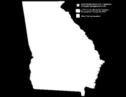
13 State Training Sessions
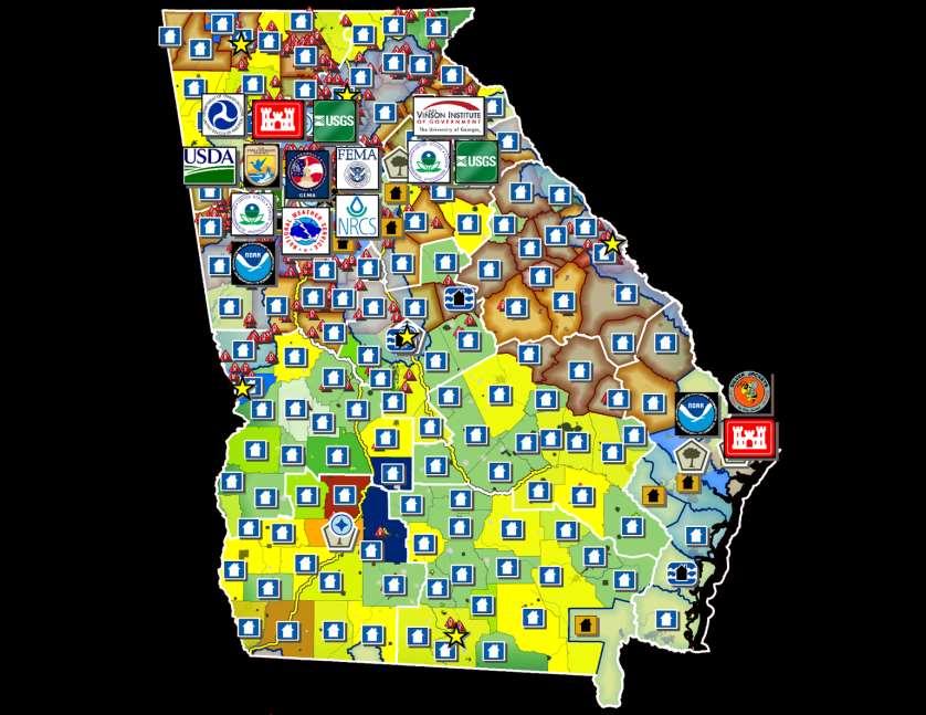
14 FY 2015 Community Assistance Visits & Technical Assistance Visits


15 Special Flood Hazard Area Project Reviews
16 Resilience Meetings

17 Community Open House Meetings
18


19 June 4, 2015 Georgia Emergency Management Agency Homeland Security GAFM Showcase: Multiple Agencies Combating Georgia s Flood Risk Together: Proven Results Gained by Strong Partnerships Terry K Lunn Hazard Mitigation Division Director
20 State Hazard Mitigation Plan Enhanced Plan Update Approved by FEMA on March 18, 2014 Recertified through March 30, 2019 Maintain Stafford Act Disaster Assistance eligibility Additional HMGP Funds (33% increase) DR1833, DR1858, DR1973, DR4165 ($13.3 million) DR4215 (TBD) State Commitment to Mitigation Local Plan Support Program Management Capability Project Implementation Capability Assessment of Mitigation Actions Utilizes funds to meet program goals
21 Local Mitigation Plan Status Strong Local-State Partnerships Initial Plan Development Grants awarded to all 159 counties 159 Multi-Jurisdictional Multi-Hazard Plans approved Governor s Customer Service Awardee First Local Plan Update Cycle Grants awarded to 158 counties One county self-funded 138 Plan Updates Approved Second Local Plan Update Cycle Grants awarded to 51 counties 1 plan update approved
22 HMA Grant Funding and Activities Disaster Hazard Mitigation Grant Program $148.6 million (1990-Present) $13.3 million extra due to Enhanced Status Non-Disaster Pre-Disaster Mitigation Program $39.5 million (2002-Present) Flood Mitigation Assistance $10.9 million (1997- Present) Total All Programs $199 million Flood Mitigation Accomplishments 1379 properties mitigated through acquisition 90 structures elevated 53 Drainage improvement projects
23 Georgia Flood MAP Support Provided copies of local mitigation plans Provided critical facility data from the State s Georgia Mitigation Information System Provided mitigated properties data which we catalogue in the Georgia Mitigation Information System Participated in all Risk MAP discovery meetings Provided summary of information on current mitigation plans Provided information on flood risk and mitigation actions Provided information on HMA grants
24 Mitigation Resources - Documents GEMA website has resources (documents and website links) to help local communities update their plans and develop mitigation projects Documents FEMA Mitigation Planning Guides GEMA Mitigation Planning Documents HM and Long term Recovery Planning HMA Pre-applications Laws Regulations Policies Other Resources Safe Rooms State Hazard Mitigation Strategy
25 Georgia Mitigation Information System Georgia Mitigation Information System (GMIS) Developed in 1995 as a tool to assist in local mitigation planning GMIS upgrade and data migration completed in December 2014 Map and Application Enhancements GMIS has >25,000 records on Critical Facility Data Data is populated by local governments to support risk assessment Expanded to include Mitigated Properties and NFIP Data Repetitive loss data (1682 Records) GMIS currently has >2,100 mitigated properties System is populated by GEMA staff at project closeout 267 repetitive loss properties mitigated GMIS currently has 332 mitigated properties with losses avoided Utilized to track open space properties
26 HAZUS Level 2 DCA awarded a HUD Resilience Grant in 2008 Partnered with Polis Center and GEMA Developed Translator for WinGAP CAMA System Utilized Critical Facility and Tax Assessor Data HAZUS Level 2 analysis and report for 4 counties Hurricane, Riverine and Coastal Flooding, Tornado PDMC and HMGP Grants Development of 6 additional translators HAZUS Level 2 for 22 counties (used for 2 nd local plan update cycle) Continue to utilize Hazard Mitigation Assistance grants for HAZUS Level 2 analysis to support local mitigation plan updates DNR Coastal Resources Division Development of 3 translators
27 Disaster Resilient Building Construction Appendices DCA awarded a HUD Resilience Grant in 2008 Develop Disaster Resilient Building Construction (DRBC) Appendices for IBC and IRC A task force of 19 stakeholders appointed to improve any provisions in the code or develop new provisions relating to hurricane, flood, and tornado disasters AdHoc Subcommittee of 7 members DRBC Appendices Optional Code+ for Flood Resistant Construction Increased freeboard over what is currently adopted Options for +1, +2, or +3 Two communities have adopted these appendices Webinar:


28 Georgia Silver Jackets Program ASFPM Conference Atlanta, GA 4 June 2015 Jeff Morris GA SJ Collaborator Savannah District USACE US Army Corps of Engineers BUILDING STRONG
29 Background Since Hurricane Katrina and other flood events, the Corps has shifted to a shared responsibility stance for Flood Risk Management (FRM) Started with a 2008 white paper by then Director of Civil Works, Major General Don Riley 2 BUILDING STRONG
30 Consequence Category Risk Flood Risk Management Program Risk-Informed Decision Making and Communication Consequence analysis ( especially populations ) Forestall possible failure mechanisms Quantify / communicate residual risk Ask which projects will fail to perform as designed, the likelihood of failure, and the consequences Recognize limits in disaster prediction Recognize limits in structural protection Overarching Approach Systems Approach River basins / Watersheds / Coastal zones From INDIVIDUAL projects to INTERDEPENDENT systems From IMMEDIATE to LONG-TERM solutions Single actions trigger > 1 system responses / reactions Adaptive Management Measure responses to interventions within systems to adjust planning, construction and operations in response to changing conditions. Integrated Water Resources Management State-of-the-Art Technology Improve resiliency of structures Update design criteria Improve approaches to planning / design Leverage remote sensing / GIS / nanotechnology /.... Coastal / River Information System Collaboration and Partnering Multiple organizations contribute to problem-solving Leverage funding, data, and talent Efficiencies, given scarce resources Sophisticated state / interstate organizations Tribes, local governments, non-profit organizations Partnering with profit-making organizations a next step Getting Ready Actions taken BEFORE the event, including planning, training, and preparations Flood Risk Management system assessment / inspections Monitoring / forecasting threats State and Local Coordination Reservoir operations Flood Fight Preparation Driving Down the Risks Activities that PREVENT a disaster, reduce its chance of happening, or reduce its damaging effects. Modify mitigation plans Identify future mitigation opportunities Develop system improvements Life-Cycle Risk Management USACE Disaster Preparedness, Levee Safety, and Silver Jackets Programs FEMA Preparedness Programs USACE FPMS, PAS, and Silver Jackets FEMA Mitigation Programs State and Local Partnerships USACE Emergency Response Program and Reservoir Operations Hazard Mitigation Plans Floodplain Management Plans Pre and Post Response and Recovery Activities NRCS Conservation Easements FEMA NRF Response Activities USACE Rehabilitation Assistance Program FEMA Mitigation, PA, and IA Programs Federal Recovery Programs The Flood Fight Actions taken DURING the initial impact of a disaster, including those to save lives and prevent further property damage Emergency system strengthening Monitor and report flood impact Monitor system performance Support State / Local FF Getting back on our feet Actions taken AFTER the initial impact, including those directed toward a return to normalcy. Repair damaged systems Assess and document system performance Implement mitigation measures / system improvements Shared Flood Risk Management Driving Down the Risks with an Informed and Engaged Public Risk-Informed Decisionmaking RISK = expected value of an unwanted event which may or may not occur Initial Risk Outreach Federal / State / Local Natural Storage Federal / State / Local Structural Federal / State / Local Non Structural Federal / State / Local Contingency Plans Federal / State / Local / Individual Building Codes State / Local Zoning Local Insurance Residual Risk All Stakeholders contribute to reducing risk! Individual / NFIP Step 1: Screening Consequences ( Threat Agnostic ) A rigorous process of: Threat-Agnostic Consequences Prioritization Threat-informed Vulnerability Assessment Probabilistic Prioritization of Investments Consistent Analysis of Alternatives Common Operating Picture Systems / Portfolio Mastery x Step 2: P ( Consequence Threat ) Vulnerability ( Internal ) I II III IV V Condition Classification A B C D F Adequate Probably Adequate x Probably Inadequate Step 3: P ( Threat ) Threat ( External ) Inadequate Failed BUILDING STRONG
31 Flood Risk Management Program Overarching Approach Adaptive Management Measure responses to interventions within systems to adjust planning, construction and operations in response to changing conditions. Risk-Informed Decision Making and Communication Consequence analysis ( especially populations ) Forestall possible failure mechanisms Quantify / communicate residual risk Ask which projects will fail to perform as designed, the likelihood of failure, and the consequences Recognize limits in disaster prediction Recognize limits in structural protection Integrated Water Resources Management State-of-the-Art Technology Improve resiliency of structures Update design criteria Improve approaches to planning / design Leverage remote sensing / GIS / nanotechnology /.... Coastal / River Information System Systems Approach River basins / Watersheds / Coastal zones From INDIVIDUAL projects to INTERDEPENDENT systems From IMMEDIATE to LONG-TERM solutions Single actions trigger > 1 system responses / reactions Collaboration and Partnering Multiple organizations contribute to problem-solving Leverage funding, data, and talent Efficiencies, given scarce resources Sophisticated state / interstate organizations Tribes, local governments, non-profit organizations Partnering with profit-making organizations a next step BUILDING STRONG

32 Risk Shared Flood Risk Management Driving Down the Risks with an Informed and Engaged Public Initial Risk Outreach Federal / State / Local Natural Storage Federal / State / Local Structural Federal / State / Local Non Structural Federal / State / Local Contingency Plans Federal / State / Local / Individual Building Codes State / Local Zoning Local Insurance Individual / NFIP Residual Risk All Stakeholders contribute to reducing risk! BUILDING STRONG

33 Life-Cycle Flood Risk Management Getting Ready Actions taken BEFORE the event, including planning, training, and preparations Flood Risk Management system assessment / inspections Monitoring / forecasting threats State and Local Coordination Reservoir operations Flood Fight Preparation Driving Down the Risks Activities that PREVENT a disaster, reduce its chance of happening, or reduce its damaging effects. Modify mitigation plans Identify future mitigation opportunities Develop system improvements USACE Disaster Preparedness, Levee Safety, and Silver Jackets Programs FEMA Preparedness Programs USACE FPMS, PAS, and Silver Jackets FEMA Mitigation Programs State and Local Partnerships Hazard Mitigation Plans Floodplain Management Plans Pre and Post Response and Recovery Activities NRCS Conservation Easements USACE Emergency Response Program and Reservoir Operations FEMA NRF Response Activities USACE Rehabilitation Assistance Program FEMA Mitigation, PA, and IA Programs Federal Recovery Programs The Flood Fight Actions taken DURING the initial impact of a disaster, including those to save lives and prevent further property damage Emergency system strengthening Monitor and report flood impact Monitor system performance Support State / Local FF Getting back on our feet Actions taken AFTER the initial impact, including those directed toward a return to normalcy. Repair damaged systems Assess and document system performance Implement mitigation measures / system improvements BUILDING STRONG
 States set priorities for Interagency Federal support Interagency Method of Delivery ( MOD")

34 Silver Jackets State Teams Operationalizing Interagency FRM Partners State-Led ( Voice of our Customers ) States set priorities for Interagency Federal support Interagency Method of Delivery ( MOD ) Existing Authorities Collaboration across agencies and levels of government Leverage resources: talent, data, funding Engaged with communities Facilitating Government Programs As of: 15 AUG 2011 BUILDING STRONG


35 Georgia Silver Jackets Flood Risk Management Team 36 BUILDING STRONG
36 About the Georgia SJ Team The Georgia Silver Jackets team brings together individuals from different agencies and fields of expertise to facilitate collaboration, share information, and leverage resources to identify areas in the state that are at risk of flooding and assist communities in reducing risks. The Georgia Silver Jackets team is a one-stop shop for city and county governments to obtain information and assistance to reduce flood risks. 37 BUILDING STRONG
37 What Can Silver Jackets Teams Do? Interagency focus on state priorities Improve overall risk communication (joint messaging) Promote comprehensive flood risk mgmt strategies and policies (shared strategies) Share information (reduce duplication, fill data gaps) Flood forecast inundation mapping Risk MAP support CRS Support Inter-state basin coordination (state-to-state and regional task forces) Storm Surge Modeling State Hazard Mitigation Plan (team assistance in updating) HAZUS data updates High Water Marks NFIP Updates FFRMS Updates BUILDING STRONG
38 Interagency Silver Jackets Projects in Georgia Levee Flood Risk Management Flood Forecast Inundation Mapping Non-Structural Flood Risk Management 39 BUILDING STRONG

39 Flood Forecast Inundation Mapping Macon Levee, GA Ocmulgee River 40 BUILDING STRONG
40 NOAA s National Weather Service Advanced Hydrologic Prediction Service Flood Inundation Mapping AHPS Website BUILDING STRONG

41 42 BUILDING STRONG

42 43 BUILDING STRONG
43 Macon Levee Flood Risk Management Interagency Project The Macon, GA levee system protects 2,900 acres of the city consisting of commercial, industrial, municipal, and agricultural properties. No residential properties. Macon Levee is not accredited by FEMA The purpose of this analysis is to prepare a HEC-RAS 2-D Model to display inundation with greater precision BUILDING STRONG
44 Flood Forecast Inundation Mapping along the Chattahoochee River 45 BUILDING STRONG

45 Flood Forecast Inundation Mapping Etowah River of the Coosa Basin City of Canton, Georgia BUILDING STRONG

46 Non-Structural Flood Risk Management Analysis for Hyde Park, Augusta, GA 47 BUILDING STRONG

47 DeKalb County Collaboration Brian Shoun, PE, CFM
48 DeKalb County Flood Mitigation County Wide Over $33 Million in grants Over $146 Million in benefits Over 88 properties acquired Still over 3,400 structures in floodplain with 90% PRE-FIRM
49 Drew Valley Project Removal of nuisance flooding 1, 2, 5, 10, 25 year events Over $ 6.6 Million in housing acquisitions Over $ 2 Million in structural improvements Detention basin and 5 box culverts Over 60 Homes protected Additional benefits

50 Drew Valley Project

51 Drew Valley Project

52 Drew Valley Project
53 City of Roswell Collaboration Alice Champagne, CFM

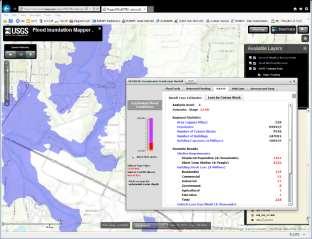
54 Flood Inundation Mapping (FIM) Program: Communicating Flood Risk and Consequences to Communities Partnership with USGS and City of Roswell and Alpharetta Project Total Cost $ 125,500 $39,450 each city $46,600 USGS Inundation Maps translate flood data into operational maps that communicate risk and the consequences of current and forecasted flooding
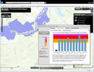
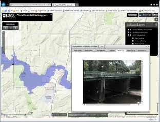
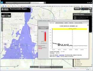
55 Flood-Inundation Map of Big Creek in Alpharetta and Roswell Big Creek was selected as inundation mapping site because of the length of record at the Big Creek streamgage ( ) National Weather Service Flood Forecast Point Flooding effects on a large number of people and structures Hydraulic Modeling developed with high resolution lidar elevation data and geospatial imagery Process creates a grid showing depths of flooding feet to 15.0 feet in 0.5 foot intervals. Results show probable areas of floodwater overlaid onto a City map which helps communities plan and respond to floods Published on the web along with an interactive online map viewer

56 Big Creek in Alpharetta and Roswell, GA Flood Levels: 7.5 ft 12.0 ft 15.0 ft

57 Big Creek at Holcomb Bridge Flood Levels: 7.5 ft 12.0 ft 15.0 ft

58 Big Creek at Kimball Bridge Flood Levels: 7.5 ft 12.0 ft 15.0 ft
59 Questions?? Alice Champagne, CFM Deputy Director City of Roswell - Environmental Public Works Department achampagne@roswellgov.com Jill Bazinet, PE CFM Senior Stormwater Engineer City of Alpharetta - Public Works Department jbazinet@alpharetta.ga.us Jonathan Musser Hydrologist USGS South Atlantic Water Science Center jwmusser@usgs.gov

60
61


62
Georgia Silver Jackets Team
 Georgia Silver Jackets Team 9 th Annual GAFM Technical Conference Jeff Morris GA SJ Collaborator Savannah District, USACE US Army Corps of Engineers SMART GOVERNMENT Integrate and synchronize flood risk
National Flood Risk Management Program
 National Flood Risk Management Program US Army Corps of Engineers Floodplain Managers Association Sacramento, California July 29, 2010 Judy Soutiere Institute for Water Resources A Shared Responsibility
Action Items for Flood Risk Management on Wildcat Creek Interagency success with floodplain management plans and flood forecast inundation maps
 Presentation to USACE 2012 Flood Risk Management and Silver Jackets Joint Workshop, Harrisburg, Pennsylvania Action Items for Flood Risk Management on Wildcat Creek Interagency success with floodplain
USACE Silver Jackets, the Missouri State Risk Management Team and State Hazard Mitigation
 MfSMA Conference, State Risk Management Team Meeting Things You Want To Know USACE Silver Jackets, the Missouri State Risk Management Team and State Hazard Mitigation Brian Rast, PE, CFM, PMP Silver Jackets
SILVER JACKETS: TEAMING TO MITIGATE AND MANAGE STATE FLOOD HAZARD PRIORITIES
 SILVER JACKETS: TEAMING TO MITIGATE AND MANAGE STATE FLOOD 255 255 255 237 237 237 0 0 0 217 217 217 163 163 163 200 200 200 131 132 122 239 65 53 80 119 27 HAZARD PRIORITIES 110 135 120 252 174.59 112
ASFPM RECOMMENDED TASK FORCE ACTIONS
 Association of State Floodplain Managers, Inc. 2809 Fish Hatchery Road, Suite 204, Madison, WI 53713 Phone: 608-274-0123 Fax: 608-274-0696 Website: www.floods.org Email: asfpm@floods.org Federal Interagency
Bucks County, PA Flood Risk Review Meeting. November 2014
 Bucks County, PA Flood Risk Review Meeting November 2014 Agenda for Today Risk MAP Program overview Overview of non-regulatory Flood Risk Products and datasets Discuss mitigation action Technical overview
Michael Taylor, PE, CFM Project Manager, AECOM August 25, 2015
 Promoting FEMA s Flood Risk Products in the Lower Levisa Watershed Michael Taylor, PE, CFM Project Manager, AECOM August 25, 2015 Agenda Study Background Flood Risk Product Overview AOMI and Mitigation
Meeting the Nation s Levee Challenges
 ASDSO USACE/FEMA Levee Discussion Meeting the Nation s Levee Challenges November 2015 Presenters: Richard Varuso, USACE Michael Bishop, FEMA 1 This Session s Objective KNOWLEDGE - Provide you with insight
Silver Jackets - Flood Risk Management Program
 COOPERATING TECHNICAL PARTNER INFORMATION EXCHANGE Silver Jackets - Flood Risk Management Program August 31, 2017 Association of State Floodplain Managers AUDIO AND WEB SETTINGS Your Participation Open
Northwest Flood Fight Workshops
 Northwest Flood Fight Workshops September 24, 2014 IWR Webinar D. Leslie Miller, P.E. (Les) Flood Preparedness Program Manager US Army Corps of Engineers, Portland District US Army Corps of Engineers Welcome
Georgia Flood M.A.P. Program
 Georgia Flood M.A.P. Program Georgia Flood M.A.P. Program The Upper Chattahoochee River Basin Risk MAP Project Transitioning State Program to align with FEMA s Risk MAP Program Increase focus on risk assessment
Improving Coordinated Flood Preparedness and Response
 Improving Coordinated Flood Preparedness and Response Illinois Silver Jackets Hank DeHaan Rock Island and Saint Louis Districts October 2011 US Army Corps of Engineers Illinois Silver Jackets Program Illinois
Use of FEMA Non regulatory Flood Risk Products in Planning
 Use of FEMA Non regulatory Flood Risk Products in Planning Georgia Association of Floodplain Managers Annual Conference March 24, 2016 What are the Non regulatory Flood Risk products? Go beyond the basic
A Flood Mitigation Plan for the Non-Tidal N.J. Section of the Delaware River Basin. Mercer County Kick-off Meeting December 6, 2006
 A Flood Mitigation Plan for the Non-Tidal N.J. Section of the Delaware River Basin Mercer County Kick-off Meeting December 6, 2006 The Delaware River. crosses many boundaries Four states: DE, PA, NJ, NY
NFIP Program Basics. KAMM Regional Training
 NFIP Program Basics KAMM Regional Training Floodplain 101 Homeowners insurance does not cover flood damage Approximately 25,000 flood insurance policies in KY According to BW12 analysis, approximately
10/5/2015. What Makes a Sound Floodplain Management Program? What are the Flood Problems in your Community?
 The Community Rating System (CRS) and Hazard Mitigation Planning Preparing Your Community Through Common Program Goals September 3, 2015 What Makes a Sound Floodplain Management Program? Know your community
This survey is expected to take approximately 20 minutes and must be completed in one session.
 State Flood Assessment Survey 1 Introduction Thank you for your willingness to participate in this online survey as part of the State Flood Assessment effort. This first step toward developing comprehensive
This survey is expected to take approximately 20 minutes and must be completed in one session.
 Introduction Thank you for your willingness to participate in this online survey as part of the State Flood Assessment effort. This first step toward developing comprehensive flood planning for Texas does
Floodplain Management Plan
 Floodplain Management Plan CITY OF FORT WORTH TFMA 2016 Spring Conference March 10, 2016 Agenda 1. Fort Worth Higher Standards (NFIP & CRS) 2. Floodplain Management Plan Overview and Results 3. Project
Erie County Flood Risk Review Meeting. January 18, 2018
 Erie County Flood Risk Review Meeting January 18, 2018 Agenda The value of updated flood maps for your community Review updated flood-risk data and important next steps in the Risk MAP process Increasing
Kentucky Risk MAP It s not Map Mod II
 Kentucky Risk MAP It s not Map Mod II Risk Mapping Assessment and Planning Carey Johnson Kentucky Division of Water carey.johnson@ky.gov What is Risk MAP? Risk Mapping, Assessment, and Planning (Risk MAP)
Delaware River Basin Commission s Role in Flood Loss Reduction Efforts
 Delaware River Basin Commission s Role in Flood Loss Reduction Efforts There is a strong need to reduce flood vulnerability and damages in the Delaware River Basin. This paper presents the ongoing role
Delaware Bay / River Coastal Flood Risk Study. FEMA REGION II and III September 19, 2012
 Delaware Bay / River Coastal Flood Risk Study FEMA REGION II and III September 19, 2012 Agenda Risk MAP Program Overview Risk MAP Non-Regulatory Products & Datasets Region II New Jersey Coastal Flood Study
Hazard Mitigation Grants. Technical Assistance Session Middlesex County, NJ December 7, 2011
 Hazard Mitigation Grants Technical Assistance Session Middlesex County, NJ December 7, 2011 Outline Purpose of Hazard Mitigation Hazard Mitigation Projects Hazard Mitigation Assistance Grant Programs Using
ASFPM Partnerships for Statewide Mitigation Actions. Alicia Williams GIS and HMP Section Manager, Amec Foster Wheeler June 2016
 ASFPM Partnerships for Statewide Mitigation Actions Alicia Williams GIS and HMP Section Manager, Amec Foster Wheeler June 2016 Summary The Concept Leveraging Existing Data and Partnerships to reduce risk
Flood Smart Communities
 Flood Smart Communities Stevie Adams, Freshwater Specialist, The Nature Conservancy Funding provided by NOAA Coastal Storms Program through Ohio Sea Grant To conserve the lands and waters on which all
ENGINEERING AND CONSTRUCTION BULLETIN
 ENGINEERING AND CONSTRUCTION BULLETIN No. 2016-8 Issuing Office: CECW-CE Issued: 22 Feb 16 Expires: 22 Feb 18 SUBJECT: Interim Risk Reduction Measures (IRRMs) for Levee Safety CATEGORY: Directive and Policy
Floodplain Management Services Baltimore District Studies
 Floodplain Management Services Baltimore District Studies FACT SHEET as of December 31, 2014 AUTHORIZATION: Floodplain Management Services (FPMS) TYPE OF PROJECT: Flood Risk Management (Technical Services)
SILVER JACKETS INTERAGENCY PROJECT POST-WILDFIRE GUIDE. Rachael Orellana, PE. Jeremy Lancaster, CEG
 SILVER JACKETS INTERAGENCY PROJECT 237 237 237 217 217 217 200 200 200 80 119 27 252 174.59 POST-WILDFIRE GUIDE 255 255 255 0 0 0 163 163 163 131 132 122 Rachael Orellana, PE 239 65 53 Flood Risk Program
Discovery Meeting: Middle Potomac- Catoctin Watershed. FEMA REGION III September 26, 2012 Rockville, MD and Fairfax, VA
 Discovery Meeting: Middle Potomac- Catoctin Watershed FEMA REGION III September 26, 2012 Rockville, MD and Fairfax, VA Agenda Introductions Purpose of This Meeting Discovery Process Community Rating System
Thurston County, WA Flood Hazard Mitigation Plan Annual Progress Report CRS Activity 510
 Thurston County, WA Flood Hazard Mitigation Plan Annual Progress Report CRS Activity 510 Reporting Period: ctober 1, 2014 to September 30, 2015 Background: Thurston County developed a flood hazard mitigation
Findings/Debrief Meeting September 9, CDOT R4 Headquarters Big Thompson Conference Room W 10 th St. Greeley, CO 80634
 Findings/Debrief Meeting September 9, 2016 CDOT R4 Headquarters Big Thompson Conference Room 10601 W 10 th St. Greeley, CO 80634 Discovery Review & Outcome May 25 Discovery Meeting Summary Summarize Data
Flood Risk Assessment in the
 Georgia Flood M.A.P. Program Flood Risk Assessment in the Upper Chattahoochee h h River Basin GAFM Annual Conference March 28, 2012 Agenda Map Mod to Risk MAP (Georgia Flood M.A.P.) transition Flood Risk
Improving Flood Hazard Identification & Flood Risk Communication: Lessons Learned from Dam Failures in South Carolina
 Improving Flood Hazard Identification & Flood Risk Communication: Lessons Learned from Dam Failures in South Carolina Katy Goolsby-Brown June 23, 2016 1 Dam Failure Incidents in South Carolina SC Dam Failures
King County Flood Control District 2015 Work Program
 Attachment A 2015 Work Plan 10-24-14 King County Flood Control District 2015 Work Program The District work program is comprised of three categories: district oversight and policy development, operations,
Georgia Flood M.A.P. Program Risk MAP Plenary Session GAFM 2011
 Georgia Flood M.A.P. Program Risk MAP Plenary Session GAFM 2011 Collis Brown, Georgia DNR March 24, 2011 GA Flood Map Modernization Responsible for end-to-end production Developed aggressive outreach program
Section 19: Basin-Wide Mitigation Action Plans
 Section 19: Basin-Wide Mitigation Action Plans Contents Introduction...19-1 Texas Colorado River Floodplain Coalition Mitigation Actions...19-2 Mitigation Actions...19-9 Introduction This Mitigation Plan,
East Hartford. Challenges
 East Hartford The Town of East Hartford is a suburban community of approximately 52,212 located east of the City of Hartford and west of the Town of Manchester. The Town covers slightly more than 18 square
CRISP COUNTY, GEORGIA AND INCORPORATED AREAS
 CRISP COUNTY, GEORGIA AND INCORPORATED AREAS Community Name Community Number ARABI, CITY OF 130514 CORDELE, CITY OF 130214 CRISP COUNTY (UNINCORPORATED AREAS) 130504 Crisp County EFFECTIVE: SEPTEMBER 25,
Terri L Turner, AICP, CFM; Region 4 Director
 ASSOCIATION OF STATE FLOODPLAIN MANAGERS Region IV Report 2012-2013 (AL, FL, GA, KY, MS, NC, SC, TN) ASFPM Annual Conference / Board Meeting Hartford, CT May 2013 Terri L Turner, AICP, CFM, Region IV Director
A Flood Mitigation Plan for the Non-Tidal N.J. Section of the Delaware River Basin. Warren County Planning Workshop (2 nd Meeting) March 7, 2007
 March 7, 2007") A Flood Mitigation Plan for the Non-Tidal N.J. Section of the Delaware River Basin Warren County Planning Workshop (2 nd Meeting) March 7, 2007 Study Area Participation: Hunterdon: 16 Eligible Municipalities
A Flood Mitigation Plan for the Non-Tidal N.J. Section of the Delaware River Basin Warren County Planning Workshop (2 nd Meeting) March 7, 2007 Study Area Participation: Hunterdon: 16 Eligible Municipalities
Flood Risk in the Schuylkill Watershed. Planning for Resilient Communities
 Flood Risk in the Schuylkill Watershed Planning for Resilient Communities Welcome to Our Poster Session! We are here to talk about: Flood Risk in the Schuylkill River Watershed Taking Action to Reduce
Chemung HUC-8 Watershed Project. February 1, 2011
 Chemung HUC-8 Watershed Project Kickoff Bi Fl t NY Big Flats, NY February 1, 2011 Introductions FEMA Region II Alan Springett, Senior Engineer, FEMA Risk Analysis Risk Assessment Lead Robert Schaefer,
ASFPM REGION 6 DIRECTOR ANNUAL REPORT. Annual Conference-Atlanta, Georgia
 ASFPM REGION 6 DIRECTOR ANNUAL REPORT Annual Conference-Atlanta, Georgia Jessica Baker, Regional Director 5/31/2015 ASFPM REGION 6 DIRECTOR ANNUAL REPORT Annual Conference-Atlanta, Georgia Region 6 Report
Location: Tampa, Florida March 6, 2013
 Discovery Meeting: West Florida Coastal Study Location: Tampa, Florida March 6, 2013 Agenda Introductions Why we are here Outline Risk MAP products and datasets Discovery Overview: Project scoping and
Flood Risk Outreach Tools for Georgia Communities. GAFM 10 th Annual Conference Presented By: Jarrett Mattli
 Flood Risk Outreach Tools for Georgia Communities GAFM 10 th Annual Conference Presented By: Jarrett Mattli April 13, 2016 Presentation Overview Guidebooks Toolkits Templates Educational Videos Resource
FLOOD INUNDATION MAPPING SCIENCE. Gardner Bent, U.S. Geological Survey, New England Water Science Center
 FLOOD INUNDATION MAPPING SCIENCE Gardner Bent, U.S. Geological Survey, New England Water Science Center What is Flood Inundation Mapping? Flood Inundation Mapping (FIM) is a real-time, operational tool
Cumberland County, NJ. Risk MAP Project Status Update April 22, 2013
 Cumberland County, NJ Risk MAP Project Status Update April 22, 2013 Agenda Project Team Milestones Risk MAP Overview Study Scope overview Regulatory products Non-regulatory products Proposed Schedule Risk
FEMA s Flood Map Modernization Preparing for FY09 and Beyond: Integrated Flood Data Update, Risk Assessment, and Mitigation Planning
 FEMA s Flood Map Modernization Preparing for FY09 and Beyond: Integrated Flood Data Update, Risk Assessment, and Mitigation Planning DRAFT CONCEPT PAPER June 1, 2007 Integrated Flood Data Update, Risk
April 3, 4, & 5, 2017 Pittsburgh, Butler, Erie Western PA
 April 3, 4, & 5, 2017 Pittsburgh, Butler, Erie Western PA 2 Hazard Mitigation is: any cost-effective action taken to eliminate or reduce the long term risk to life and property from natural and technological
Upper Joachim Creek Public Survey on Potential Flood Risk Reduction
 Upper Joachim Creek Public Survey on Potential Flood Risk Reduction This survey is intended to help the interagency planning committee to receive public feedback on specific flood risk reduction techniques,
A Flood Mitigation Plan for the Non-Tidal N.J. Section of the Delaware River Basin. Sussex County Kick-off Meeting November 28, 2006
 A Flood Mitigation Plan for the Non-Tidal N.J. Section of the Delaware River Basin Sussex County Kick-off Meeting November 28, 2006 The Delaware River. crosses many boundaries Four states: DE, PA, NJ,
National Flood Risk Management Program
 National Flood Risk Management Program Program Management Plan 2 July 2012 US Army Corps of Engineers BUILDING STRONG Page Left Intentionally Blank. FRM Program Management Plan 2 July 2012 2 TABLE OF CONTENTS
Sea Level Rise and the NFIP
 Cheryl A Johnson, PE, CFM, PMP March 26, 2014 http://www.globalchange.gov/ Sea-level rise and the likely increase in hurricane intensity and associated storm surge will be among the most serious consequences
Non Regulatory Risk MAP Products Flood Depth and Probability Grids
 Non Regulatory Risk MAP Products Flood Depth and Probability Grids Virginia Floodplain Management Association 2015 Floodplain Management Workshop October 29th, 2015 Nabil Ghalayini, P.E., PMP, D.WRE, CFM
ASFPM Update. GAFM 10 th Annual Technical Conference March 24, 2016
 ASFPM Update GAFM 10 th Annual Technical Conference March 24, 2016 AND HE SAID Floods are 'acts of God,' but flood losses are largely acts of man. 1945 PhD Dissertation Human Adjustments to Flood by Gilbert
Joint Recommendations on Levee Policy. Association of State Floodplain Managers. National Association of Flood and Stormwater Management Agencies
 Joint Recommendations on Levee Policy developed by the Association of State Floodplain Managers and the National Association of Flood and Stormwater Management Agencies from discussions at the Flood Risk
in coordination with Peoria County, Planning and Zoning Department
 Prepared by Amec Foster Wheeler Environment & Infrastructure Hazard Mitigation and Emergency Management Program in coordination with Peoria County, Planning and Zoning Department The purpose of hazard
Flood Plain Management Services (FPMS) Program
 Program") Flood Plain Management Services (FPMS) Program 2016 Winter Stakeholder Partnering Forum March 2016 Mario Beddingfield, P.E., CFM Hydraulic Engineer/FPMS Program Manager H&H/Water Control Branch U.S. Army
Flood Plain Management Services (FPMS) Program 2016 Winter Stakeholder Partnering Forum March 2016 Mario Beddingfield, P.E., CFM Hydraulic Engineer/FPMS Program Manager H&H/Water Control Branch U.S. Army
Attachment B. King County Flood Control Zone District Work Program
 Attachment B King County Flood Control Zone District Work Program The King County Flood Control Zone District work program is comprised of two major categories: Programmatic Work Program o Flood Preparedness,
County of Kaua'i Multi-Hazard Mitigation and Resilience Plan, 2015 Update
 Executive Summary: County of Kaua'i Multi-Hazard Mitigation and Resilience Plan Introduction to the Mitigation and Resilience Plan In this third plan, the longer term needs for sustaining mitigation efforts
MUNICIPAL LAND USE STRATEGIES for Improving Flood Resilience
 MUNICIPAL LAND USE STRATEGIES for Improving Flood Resilience Strategy for a Flood Resistant Southern Tier Central Region (LWRP project) This presentation was prepared by Southern Tier Central Regional
Disaster Insurance: Are States and Insurance Companies Prepared?
 Disaster Insurance: Are States and Insurance Companies Prepared? National Conference of State Legislatures 2015 Legislative Summit Roy Wright Deputy Associate Administrator for Insurance and Mitigation
CONTINUING AUTHORITIES PROJECT (CAP) Federal Interest Determination
 Federal Interest Determination") Date: 8 May 2013 Division: Great Lakes and Ohio River Division District: Nashville District CONTINUING AUTHORITIES PROJECT (CAP) Federal Interest Determination 1. Project: Cumberland River, Metropolitan
Date: 8 May 2013 Division: Great Lakes and Ohio River Division District: Nashville District CONTINUING AUTHORITIES PROJECT (CAP) Federal Interest Determination 1. Project: Cumberland River, Metropolitan
TESTIMONY. Association of State Floodplain Managers, Inc. Subcommittee on Transportation and Infrastructure
 ASSOCIATION OF STATE FLOODPLAIN MANAGERS, INC. 2809 Fish Hatchery Road, Suite 204, Madison, Wisconsin 53713 www.floods.org Phone: 608-274-0123 Fax: 608-274-0696 Email: asfpm@floods.org TESTIMONY Association
In 1993, spring came in like a lion, but refused
 36 UNIVERSITIES COUNCIL ON WATER RESOURCES ISSUE 130, PAGES 36-40, MARCH 2005 FEMA and Mitigation: Ten Years After the 1993 Midwest Flood Norbert Director of Federal Insurance and Mitigation Division Federal
Cameron County, TX. Consultation Coordination Officer (CCO) Meeting. Please sign in (sheet at front of the room) Meeting will begin at 9:00
 Meeting. Please sign in (sheet at front of the room) Meeting will begin at 9:00") Cameron County, TX Consultation Coordination Officer (CCO) Meeting Please sign in (sheet at front of the room) Meeting will begin at 9:00 July 29, 2015 Lisa Jennings FEMA Region 6 Roles & Responsibilities
Cameron County, TX Consultation Coordination Officer (CCO) Meeting Please sign in (sheet at front of the room) Meeting will begin at 9:00 July 29, 2015 Lisa Jennings FEMA Region 6 Roles & Responsibilities
Piloting LAMP from Stream to Sea
 Piloting LAMP from Stream to Sea FEMA s New Analysis and Mapping Procedures for Non-Accredited Levee Systems Presented by: Eric Simmons, CFM Senior Engineer, FEMA Region IX Presentation Outline Levee Issues
Role of Disaster Insurance in Improving Resilience: An Expert Meeting The Resilient America Roundtable
 Role of Disaster Insurance in Improving Resilience: An Expert Meeting The Resilient America Roundtable National Academy of Science Washington, DC July 9, 2015 Roseville Demographics Primary population
G318 Local Mitigation Planning Workshop. Module 2: Risk Assessment. Visual 2.0
 G318 Local Mitigation Planning Workshop Module 2: Risk Assessment Visual 2.0 Unit 1 Risk Assessment Visual 2.1 Risk Assessment Process that collects information and assigns values to risks to: Identify
Passaic River Basin Flood Advisory Commission Report/Status of Recommendations. October 2014 Update
 Passaic River Basin Flood Advisory Commission Report/Status of Recommendations October 2014 Update Passaic River Basin Flood Advisory Commission April 2010: By Executive Order, Governor Christie created
Discovery Report. Cache River Watershed, Alexander, Johnson, Pulaski, and Union Counties, Illinois
 Discovery Report Cache River Watershed, 07140108 Alexander, Johnson, Pulaski, and Union Counties, Illinois 12/21/2012 i Project Area Community List Community Name Alexander County Village of Tamms Johnson
FLOODPLAIN MANAGEMENT: A PRESENT AND A 21st CENTURY IMPERATIVE. Gerald E. Galloway, Jr. United States Military Academy
 FLOODPLAIN MANAGEMENT: A PRESENT AND A 21st CENTURY IMPERATIVE Gerald E. Galloway, Jr. United States Military Academy Introduction The principal rivers of the United States and their tributaries have played
Terri L Turner, AICP, CFM; Region 4 Director
 ASSOCIATION OF STATE FLOODPLAIN MANAGERS Region IV Report 2011-2012 (AL, FL, GA, KY, MS, NC, SC, TN) ASFPM Annual Conference / Board Meeting San Antonio, Texas May 2012 Terri L Turner, AICP, CFM, Region
FEMA FLOOD MAPS Public Works Department Stormwater Management Division March 6, 2018
 FEMA FLOOD MAPS Public Works Department Stormwater Management Division March 6, 2018 Presentation Overview FEMA National Flood Insurance Program (NFIP) FEMA Community Rating System (CRS) Flood Insurance
9.10 HEIDELBERG TOWNSHIP
 9.10 HEIDELBERG TOWNSHIP This section presents the jurisdictional annex for Heidelberg Township. A. HAZARD MITIGATION PLAN POINT OF CONTACT Name Title/ Department Address Telephone Fax Email Primary Point
Table 1: Federal, State and Local Government Rules applicable to LOMRs/CLOMRS submittal
 MnDNR LOMC Guide This document has been prepared by the Minnesota Department of Natural Resources floodplain staff and is intended to provide assistance with LOMR/CLOMR submittals. This information is
2011 MT Floods Damages and Recovery Options
 MONTANA 2011 MT Floods Damages and Recovery Options Damage Estimates Public Works: Between $57.5 million Individual: id Housing Assistance $4,442,194 Small Business Assistance $1,634,100 Other Needs
David A. Stroud, CFM AMEC Earth & Environmental Raleigh, NC
 David A. Stroud, CFM AMEC Earth & Environmental Raleigh, NC Objectives Risk MAP background North Carolina s Risk MAP role Role of communication in Risk MAP Effective risk communication two examples Multi-hazard
Facts & Info regarding the NFIP in Mathews County VA And the Mathews County Floodplain Management Ordinance
 Facts & Info regarding the NFIP in Mathews County VA And the Mathews County Floodplain Management Ordinance As of 05-31-2014: Current NFIP policies in Mathews County = 1687 NFIP Claims= 1127, for a total
Levees: PL84-99 and the NFIP
 Levees: PL84-99 and the NFIP Tony D. Krause, P.E., CFM Flood Risk and Floodplain Management Omaha District US Army Corps of Engineers Objectives and Overview Objectives: Identify overlaps between Federal
Fighting the Flood: Current Political, Regulatory and Financial Challenges
 Fighting the Flood: Current Political, Regulatory and Financial Challenges for Levee Owners Kansas City, Missouri January 23, 2013 Emerging Policy, Programs and Tools for the Management of Levee Systems
Sussex County All Hazard Mitigation Plan. Plan Executive Summary
 Sussex County All Hazard Mitigation Plan Plan Executive Summary March 2010 SUSSEX COUNTY ALL HAZARD MITIGATION PLAN SUMMARY March 2010 For questions and to make comments on this document, contact: Joseph
U.S. Updates: Climate Change, Maintenance and Investigations
 U.S. Updates: Climate Change, Monitoring, Assessment, Maintenance and Investigations Edward d J. Hecker Chief, Office of Homeland Security and Provost Marshal, Directorate of Civil Works June 15, 2010
USACE Support to Interagency Projects What Is Funded & Why?
 USACE Support to Interagency Projects What Is Funded & Why? Lisa Bourget, P.E. Senior Water Resources Engineer Jennifer Dunn, CFM Silver Jackets Program USACE, Institute for Water Resources June 4, 2015
Planning for SLR Resiliency in Virginia Beach
 Old Dominion University ODU Digital Commons May 18, 2016: The Economic Impacts of Sea-Level Rise in Hampton Roads Hampton Roads Intergovernmental Pilot Project: Meetings 5-18-2016 Planning for SLR Resiliency
ADVISORY BASE FLOOD ELEVATIONS (ABFEs)
") The Department of Homeland Security s Federal Emergency Management Agency is committed to helping communities that were impacted by Hurricanes Katrina and Rita rebuild safer and stronger. Following catastrophic
The Department of Homeland Security s Federal Emergency Management Agency is committed to helping communities that were impacted by Hurricanes Katrina and Rita rebuild safer and stronger. Following catastrophic
ASFPM REGION 7 DIRECTOR ANNUAL REPORT. Annual Conference-Atlanta, Georgia
 ASFPM REGION 7 DIRECTOR ANNUAL REPORT Annual Conference-Atlanta, Georgia Shanna Michael ASFPM REGION 7 DIRECTOR ANNUAL REPORT Annual Conference-Atlanta, Georgia Region 7 encompasses Iowa, Kansas, Missouri,
Authors: Terry Zien, Brian Rast and the Silver Jackets Co presenters: Brian Rast, Dave Lupardus and Frank Dolan
 Authors: Terry Zien, Brian Rast and the Silver Jackets Co presenters: Brian Rast, Dave Lupardus and Frank Dolan http://www.mvp.usace.army.mil/missions/civilworks/floodriskm anagement/emergencyactionplanguidebook.aspx
ASFPM Update OUR CHALLENGE. Floods are 'acts of God,' but flood losses are largely acts of man. Fall, 2016
 ASFPM Update Fall, 2016 OUR CHALLENGE Floods are 'acts of God,' but flood losses are largely acts of man. 1945 PhD Dissertation Human Adjustments to Flood by Gilbert F. White 1 OUR CHALLENGE Credit: Chopperguy
Best Practices. for Incorporating Building Science Guidance into Community Risk MAP Implementation November 2012
 Best Practices for Incorporating Building Science Guidance into Community Risk MAP Implementation November 2012 Federal Emergency Management Agency Department of Homeland Security 500 C Street, SW Washington,
Levee Safety The Middle Age Of Levee Safety Development
 Levee Safety The Middle Age Of Levee Safety Development HDR Showcase Panel Discussion June 22, 2016 Living the Current Changing Regulatory Climate by Roger Less, PE, CFM Overview of Section 408 Permit
Riverine Flooding - Cedar Rapids, Iowa 2008
 Katrina 2005 Riverine Flooding - Cedar Rapids, Iowa 2008 Riverine and Pluvial Flooding Nashville 2010 Mississippi and Missouri Rivers 2011 INFRASTRUCTURE ECONOMY 21 st Century 20 th Century "Toto, I've
Flood Risk Products. New Techniques for Identifying and Communicating Flood Risk
 Flood Risk Products New Techniques for Identifying and Communicating Flood Risk Mark Zito, GISP, CFM GIS Specialist Amol Daxikar, GISP, CFM Project Manager March 28, 2012 1% Flood with 3 Feet Sea Level
FLOOD STUDY Atlantic County, NJ. FEMA REGION II July 12, :00
 FLOOD STUDY Atlantic County, NJ FEMA REGION II July 12, 2011 14:00 Agenda Introductions FEMA Strategic Plan & Risk Mapping, Assessment, and Planning (Risk MAP) Goals Risk MAP Program Overview Meeting Objectives
TESTIMONY. Association of State Floodplain Managers, Inc.
 ASSOCIATION OF STATE FLOODPLAIN MANAGERS, INC. 2809 Fish Hatchery Road, Suite 204, Madison, Wisconsin 53713 www.floods.org Phone: 608-274-0123 Fax: 608-274-0696 Email: asfpm@floods.org TESTIMONY Association
King County Flood Control District Flood Risk Reduction Work Program and Accomplishments
 King County Flood Control District Flood Risk Reduction Work Program and Accomplishments Brian Murray Water and Land Resources Division April 26, 2016 Department of Natural Resources and Parks Water and
FINAL TECHNICAL MEMORANDUM AWD FLOWS THROUGH FLOOD DAMAGE REDUCTION AREA July 16, 2012
 FINAL TECHNICAL MEMORANDUM AWD-00002 FLOWS THROUGH FLOOD DAMAGE REDUCTION AREA July 16, 2012 Table of Contents TABLE OF CONTENTS Table of Contents... 1 Executive Summary... 2 1 Objective... 4 2 Study Approach...
Strategies for Increasing Flood Resiliency
 Strategies for Increasing Flood Resiliency Flood Hazard Mitigation Steve Ferryman, CFM Mitigation Branch Chief Ohio Emergency Management Agency Ohio EMA Mitigation Branch The mission of the Mitigation