King County Flood Control District Flood Risk Reduction Work Program and Accomplishments
|
|
|
- Ellen Hodge
- 6 years ago
- Views:
Transcription

1 King County Flood Control District Flood Risk Reduction Work Program and Accomplishments Brian Murray Water and Land Resources Division April 26, 2016 Department of Natural Resources and Parks Water and Land Resources Division River and Floodplain Management Section
2 Presentation Overview Floodplain Management in King County: Past and Present Flood Risk Reduction Program Objectives Regulatory and Planning Context Partnerships to Reduce Flood Risks Accomplishments to Date Capital Project Prioritization Policies and Corridor Planning Flood Risk Reduction Strategies and Capital Projects by River System

3 3 Key King County River Engineering Activities and Dates 1899: Landsburg Diversion Cedar River 1906: White River Diverted (permanently in 1912) 1912: Cedar River Diverted to Lake Washington 1913: Tacoma Public Utilities Headworks Green R. 1914: Cedar River Masonry Dam 1948: Mud Mountain Dam White River 1962: Howard Hanson Dam Green River 1964: South Fork Tolt River Dam 1966: Sammamish River Channelization 1930s-1970s: 500 levees & revetments constructed 3


4 Ecomomic Impacts of Flooding 32,000 Floodplain Residents 65,000 jobs $3.7 Billion in total income 30% of aerospace jobs 20% of manufacturing / wholesale trade jobs Critical Infrastructure

5 Three objectives: Reduce risks from flood and channel migration hazards Minimize the environmental impacts of flood projects Reduce long term maintenance costs
6 Flood Control District Operating Programs How do we reduce flood risks? 1. Identify hazards 2. Assess risk and vulnerabilities 3. Build awareness of hazards 4. Develop a plan and strategy to reduce risks 5. Actions to avoid risk 6. Actions to reduce or mitigate risk 7. Evaluate, learn, and adjust ILA Work Program Categories 1. Flood Preparedness, Regional Flood Warning Center, and Post Flood Recovery 2. Planning, Grants, Mitigation, and Public Outreach 3. Flood Hazard Assessments, Mapping, and Technical Studies 4. Resource Management, Annual Maintenance, and Facility Monitoring 5. Capital Investments: Construction and Repair, Acquisitions and Elevation

7 Tools to reduce but not eliminate risk: Source: FEMA and USACE
8 Eligibility requires regular inspections and compliance with Corps levee maintenance requirements Activity Who are our partners in reducing flood risk? Communicating Risk: Flood Warning and Preparedness Planning and Prioritizing Actions Partners USGS, NOAA, Corps, Seattle, Emergency Management, local governments Take Winter by Storm regional partnership Local governments through Basin Technical Committees and Advisory Committee Actions to Reduce Risk Project Design, Permitting, and Mitigation Funding to Support Regional Partners Maintenance and Repairs Corps, FEMA, Ecology, local governments, funding partners Fisheries co-managers (tribes and WDFW), Corps, Ecology, local agencies Provide $12.9 million in 2016 to jurisdictions, agencies, non-profits, and tribes to support complementary floodplain management efforts. Federal funding following disasters for levees (Corps PL 84-99) and revetments (FEMA public assistance)
9 Funding Partnership Examples Grant Source Corps PL Levee Repairs What is it for? Cost-share levee repairs following federally-declared disasters. Corps will fund repairs to levees (structures that contain floodwaters) but not revetments. Levee maintenance policies for vegetation on levees have been the subject of much debate over the last several years; the Corps SWIF process offers an alternative to resolve these debates. Program is generally more cost-effective in constrained urban areas like the Green than in less constrained areas with higher quality habitat like the Snoqualmie and Cedar. FEMA Public Assistance Revetment Repairs FEMA Hazard Mitigation Grants Floodplains by Design Cost-share revetment repairs following federally-declared disasters, plus flood response costs. FEMA will fund repairs to revetments (structures that prevent riverbank erosion but do not contain floods). Cost-share acquisition and elevation of at-risk homes. Majority of the available funding is intended to reduce insurance claims to the National Flood Insurance Program; in recent years funding tends to go toward homes that have insurance and multiple large damage claims in the Southeast United States. State capital funding through the Department of Ecology. Funding for large-scale multi-objective projects combining public safety, habitat

10 Overview of Accomplishments 79 projects to reduce flood risks 64 homes elevated, with 12 more underway 27 farm pads built for flood refuge, 3 agricultural structures elevated Barn Elevation, Lower Snoqualmie Valley 186 at-risk structures acquired on 450 acres to move people out of harms way 6,500 Flood Alert subscribers, 2,600 flood app downloads Flood Warning Center opened 43 times, 1,296 hours of operation Over $52 million for multi-objective projects from multiple grant sources


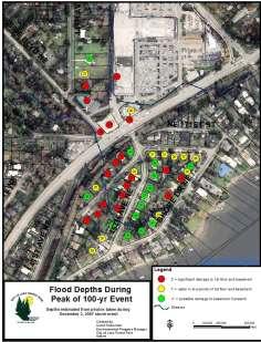
11 Accomplishment: Improved channel migration mapping Cedar River Channel Migration Maps (2015) Taylor Creek Confluence Next: South Fork Skykomish, Tolt, White

12 Accomplishment: Landslide Investigation (Major River Floodplains)


13 Accomplishment: Improving flood awareness Flood safety videos available in 22 languages Flood Update mailed to 18,000 floodplain addresses each year Flood information available in multiple languages


14 Accomplishment: Flood Warning and Patrols Warning Center activated 43 times for 1,296 hours Over 6,500 flood alert subscribers Smart phone application over 4,800 subscribers

15 Accomplishment: Cedar River Rainbow Bend
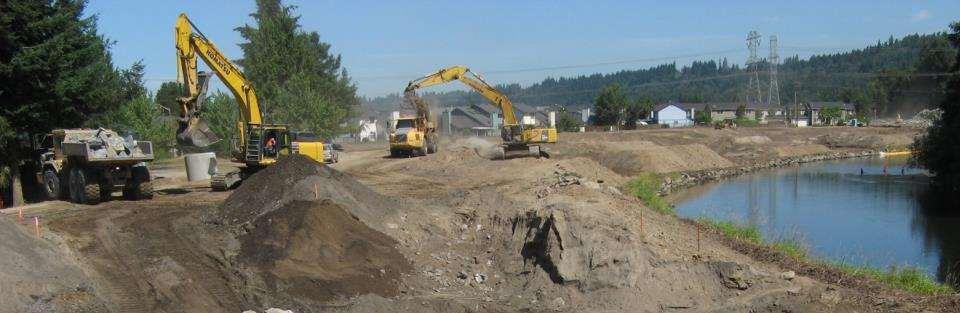

16 Accomplishment: Green River Reddington Levee


17 Upcoming Projects South Fork Snoqualmie, I-90 / North Bend ( ) White River, Countyline ( ) Lower Snoqualmie Tolt Pipeline (2017)

18 Upcoming Projects: Willowmoor 23

19 City Partnership Projects Seattle ( ) Lake Forest Park (2015) Bellevue ( ) Renton ( )
 $10.")

20 Corps Levee Repair Partnerships ( ) $10.8 million total project cost $4.5 million local share Desimone Reach 1 Floodwall, Tukwila Dykstra Levee, Auburn
21 Evaluation Criteria: Project Evaluation Approach Implementation Opportunity Potential Address Project RESCOPE Constraints or Rescope High Flood Risk Reduction Potential Medium Priority Priority NOT A PRIORITY Low Priority NOTE: This is a conceptual diagram and is not intended to imply clear and distinct thresholds between these categories.
 Tolt (2016) MF Snoqualmie (2017) SF Snoqualmie (2016) Cedar (2016) Lower")
22 Capital Project Planning River Corridor Plans Corridor Planning Phase Phase 1: Risk Characterization Phase 2: 6-year Capital Investment Plan based on existing placeholder funding Phase 3: Integrative multi-objective plans River System Cedar (2016) Tolt (2016) MF Snoqualmie (2017) SF Snoqualmie (2016) Cedar (2016) Lower Green River
23


24 Snoqualmie and South Fork Skykomish Flood Risks Flood inundation Channel migration Bank erosion Alluvial fan hazards


25 South Fork Snoqualmie Corridor Plan Existing Conditions 100-yr Flow 500-yr Flow

26 South Fork Snoqualmie 6-Year Capital Investment Strategy FCD adopted framework with goals, objectives, approaches Characterization of conditions complete Stakeholder and public meetings last October Alternatives evaluation nearly complete FCD Possible Action Sept 2016 Setting up for a boring to evaluate levee stability

27 Tolt River 6-Year Capital Investment Strategy Lower Tolt River upstream of Carnation Levees unstable, do not contain floodwaters 60 homes in high risk areas Hwy 203 and Tolt River Road subject to inundation FCD adopted framework with goals, objectives, approaches Characterization of conditions nearly complete Stakeholder and public meetings January 2015
28


29 Cedar River Strategy Reduce flood velocities and volumes that threaten critical public infrastructure, residential dwellings, and block sole-access roads Reduce public safety risks associated with neighborhood-scale flooding and channel migration


30 Cedar River Corridor Plan Complete risk characterization 6-year capital investment strategy in 2016
31 General Approach to Corridor Plans Multi-objective: Scope and goals based on Flood Plan and County policies Flood inundation, erosion, channel migration where applicable Ecological resources, including salmon habitat where present Economy, agriculture, recreation, other community goals Characterize existing and potential future conditions Develop and evaluate alternatives Long-term: What will it take to be done? Near-term: Priority actions for 6-10 year CIP Recommend long-term strategy and near-term actions Key is to customize to the needs of the river basin and segment!


32 Green River System-Wide Improvement Framework (SWIF) Interim SWIF submitted to Corps in Feb 2016 Maintain eligibility for Corps repair funding Lower Green River Corridor Plan and EIS Potential Exec Cmte action in June


33 Lower Russell Rd Levee Setback Lower Russell Road, Green River Reconstruct 1.4 mile levee to improve flood protection, restore habitat, and enhance recreational opportunities $43 Million total project cost $17.4 Million FCD $4.9 Million WA State Floodplains by Design grant funding
34
35 Questions? Brian Murray, Environmental Programs Managing Supervisor (206)
King County Flood Control District 2015 Work Program
 Attachment A 2015 Work Plan 10-24-14 King County Flood Control District 2015 Work Program The District work program is comprised of three categories: district oversight and policy development, operations,
Attachment B. King County Flood Control Zone District Work Program
 Attachment B King County Flood Control Zone District Work Program The King County Flood Control Zone District work program is comprised of two major categories: Programmatic Work Program o Flood Preparedness,
Action Items for Flood Risk Management on Wildcat Creek Interagency success with floodplain management plans and flood forecast inundation maps
 Presentation to USACE 2012 Flood Risk Management and Silver Jackets Joint Workshop, Harrisburg, Pennsylvania Action Items for Flood Risk Management on Wildcat Creek Interagency success with floodplain
KCFCDEC May 6,
 King County Meeting Agenda King County Flood Control District Executive Committee 1200 King County Courthouse 516 Third Avenue Seattle, WA 98104 Boardmembers: Reagan Dunn, Chair; Julia Patterson, Vice
BUYOUTS/RELOCATION/FLOODPROOFING: REGULATORY PROGRAMS AND EXPERIENCE IN OTHER COMMUNITIES
 BUYOUTS/RELOCATION/FLOODPROOFING: REGULATORY PROGRAMS AND EXPERIENCE IN OTHER COMMUNITIES The following provides details on new federal and state programs, including associated funding options for program
SWIF TO THE RESCUE. Patty Robinson Ike Pace, PE WATER NATURAL RESOURCES ENVIRONMENT INFRASTRUCTURE ENERGY
 SWIF TO THE RESCUE Patty Robinson Ike Pace, PE WATER NATURAL RESOURCES ENVIRONMENT INFRASTRUCTURE ENERGY AGENDA USACE Programs PL 84 99 (Rehabilitation & Inspection Program, RIP) Levee Safety Program (Routine,
King County, WA DFIRM Update and Seclusion Process. Webinar June 14, 2016
 King County, WA DFIRM Update and Seclusion Process Webinar June 14, 2016 Agenda King County DFIRM Study History What is/has been done Process for moving forward Seclusion Seclusion mapping process Seclusion
King County Flood Control District Advisory Committee Meeting:
 King County Flood Control District Advisory Committee Meeting: Introduction to the Draft 2019-2024 Capital Program Brian Murray and Lorin Reinelt Water and Land Resources Division July 20, 2018 Department
U.S. Army Corp of Engineers
 U.S. Army Corp of Engineers PL 84-99 Levee Inspections and Levee Certification Hank DeHaan Rock Island District March 9, 2011 US Army Corps of Engineers U.S. Army Corps of Engineers Flood Damage Reduction
Georgia Silver Jackets Team
 Georgia Silver Jackets Team 9 th Annual GAFM Technical Conference Jeff Morris GA SJ Collaborator Savannah District, USACE US Army Corps of Engineers SMART GOVERNMENT Integrate and synchronize flood risk
Thursday, August 10, 2017, 9:30 a.m. 12:00 p.m. Mercer Island Community Center 8236 SE 24th St, Mercer Island, WA 98040
 MEETING TIME AND LOCATION Thursday, August 10, 2017, 9:30 a.m. 12:00 p.m. Mercer Island Community Center 8236 SE 24th St, Mercer Island, WA 98040 PURPOSE OF THE MEETING Discuss 2018 Draft Operating Budget
Exhibit I SETTLEMENT AGREEMENT BETWEEN CITY OF TACOMA, KING COUNTY AND FRIENDS OF GREEN RIVER
 Exhibit I SETTLEMENT AGREEMENT BETWEEN CITY OF TACOMA, KING COUNTY AND FRIENDS OF GREEN RIVER Whereas, City of Tacoma Water Division ("Tacoma") is proposing to build a water transmission pipeline that
Section 19: Basin-Wide Mitigation Action Plans
 Section 19: Basin-Wide Mitigation Action Plans Contents Introduction...19-1 Texas Colorado River Floodplain Coalition Mitigation Actions...19-2 Mitigation Actions...19-9 Introduction This Mitigation Plan,
Natural Hazards Mitigation Plan Kankakee County, Illinois Executive Summary
 1. Introduction Natural Hazards Mitigation Plan Kankakee County, Illinois Executive Summary Kankakee County is subject to natural hazards that threaten life, safety, health, and welfare and cause extensive
SILVER JACKETS: TEAMING TO MITIGATE AND MANAGE STATE FLOOD HAZARD PRIORITIES
 SILVER JACKETS: TEAMING TO MITIGATE AND MANAGE STATE FLOOD 255 255 255 237 237 237 0 0 0 217 217 217 163 163 163 200 200 200 131 132 122 239 65 53 80 119 27 HAZARD PRIORITIES 110 135 120 252 174.59 112
PUBLIC SURVEY FOR HAZARD MITIGATION PLANNING
 PUBLIC SURVEY FOR HAZARD MITIGATION PLANNING We need your help! The Counties of Cherokee, Graham, Haywood, Jackson, Swain, and the Eastern Band of Cherokee Indians are currently engaged in a planning process
Thurston County, WA Flood Hazard Mitigation Plan Annual Progress Report CRS Activity 510
 Thurston County, WA Flood Hazard Mitigation Plan Annual Progress Report CRS Activity 510 Reporting Period: ctober 1, 2014 to September 30, 2015 Background: Thurston County developed a flood hazard mitigation
Appendix A. Plan Formulation. Puyallup River Basin Flood Risk Management Feasibility Study
 Appendix A Plan Formulation Puyallup River Basin Flood Risk Management Feasibility Study Department of the Army Seattle District, US Army Corps of Engineers March 2016 This page intentionally left blank
Justification for Floodplain Regulatory Standards in Illinois
 Justification for Floodplain Regulatory Standards in Illinois Office of Water Resources Issue Paper April, 2015 Proactive Illinois floodplain and floodway regulatory standards have prevented billions of
A Flood Mitigation Plan for the Non-Tidal N.J. Section of the Delaware River Basin. Warren County Planning Workshop (2 nd Meeting) March 7, 2007
 March 7, 2007") A Flood Mitigation Plan for the Non-Tidal N.J. Section of the Delaware River Basin Warren County Planning Workshop (2 nd Meeting) March 7, 2007 Study Area Participation: Hunterdon: 16 Eligible Municipalities
A Flood Mitigation Plan for the Non-Tidal N.J. Section of the Delaware River Basin Warren County Planning Workshop (2 nd Meeting) March 7, 2007 Study Area Participation: Hunterdon: 16 Eligible Municipalities
in coordination with Peoria County, Planning and Zoning Department
 Prepared by Amec Foster Wheeler Environment & Infrastructure Hazard Mitigation and Emergency Management Program in coordination with Peoria County, Planning and Zoning Department The purpose of hazard
Dade County Natural Hazard Mitigation Plan
 Introduction to Mitigation Definition of Mitigation Mitigation is defined by FEMA as "...sustained action that reduces or eliminates longterm risk to people and property from natural hazards and their
Delaware River Basin Commission s Role in Flood Loss Reduction Efforts
 Delaware River Basin Commission s Role in Flood Loss Reduction Efforts There is a strong need to reduce flood vulnerability and damages in the Delaware River Basin. This paper presents the ongoing role
PUBLIC AWARENESS SURVEY. Prepared by Cocker Fennessy, Inc.
 GREEN RIVER VALLEY FLOODING PUBLIC AWARENESS SURVEY Prepared by September 17, 2009 Objectives Assess public awareness & concern of flood risk Identify actions residents are taking to prepare Determine
GENERAL PLAN AMENDMENT # FLOOD HAZARDS
 GENERAL PLAN AMENDMENT #2011-03 FLOOD HAZARDS The following text that appears on pages HS 3-4 of the Health and Safety Element in the Yolo 2030 Countywide General Plan has been amended. New language is
Community Development Department
 Community Development Department Ryan DeVore, Interim Director of Community Development Scot Mende, Principal Planner Bill Busath, Interim Director of Utilities Connie Perkins, Senior Engineer, Floodplain
Community Rating System. National Flood Insurance Program
 National Flood Insurance Program Community Rating System A Local Official s Guide to Saving Lives Preventing Property Damage Reducing the Cost of Flood Insurance FEMA B-573 / May 2015 How the Community
Crediting Adaptation Strategies through the National Flood Insurance Program s Community Rating System Coordinator s Manual
 Crediting Adaptation Strategies through the National Flood Insurance Program s Community Rating System Coordinator s Manual W. Thomas Hawkins, Adjunct Faculty, University of Florida, Levin College of Law
University Drive Flood Risk Management Project Phase I 58 th Ave S to 500 S of 64 th Ave S City of Fargo Project FM-15-C1
 University Drive Flood Risk Management Project Phase I 58 th Ave S to 500 S of 64 th Ave S City of Fargo Project FM-15-C1 Public Informational Meeting October 15, 2015 6:00 P.M. Overview Flood Risk FEMA
2011 MT Floods Damages and Recovery Options
 MONTANA 2011 MT Floods Damages and Recovery Options Damage Estimates Public Works: Between $57.5 million Individual: id Housing Assistance $4,442,194 Small Business Assistance $1,634,100 Other Needs
CONTINUING AUTHORITIES PROJECT (CAP) Federal Interest Determination
 Federal Interest Determination") Date: 8 May 2013 Division: Great Lakes and Ohio River Division District: Nashville District CONTINUING AUTHORITIES PROJECT (CAP) Federal Interest Determination 1. Project: Cumberland River, Metropolitan
Date: 8 May 2013 Division: Great Lakes and Ohio River Division District: Nashville District CONTINUING AUTHORITIES PROJECT (CAP) Federal Interest Determination 1. Project: Cumberland River, Metropolitan
G318 Local Mitigation Planning Workshop. Module 2: Risk Assessment. Visual 2.0
 G318 Local Mitigation Planning Workshop Module 2: Risk Assessment Visual 2.0 Unit 1 Risk Assessment Visual 2.1 Risk Assessment Process that collects information and assigns values to risks to: Identify
Vocabulary of Flood Risk Management Terms
 USACE INSTITUTE FOR WATER RESOURCES Vocabulary of Flood Risk Management Terms Appendix A Leonard Shabman, Paul Scodari, Douglas Woolley, and Carolyn Kousky May 2014 2014-R-02 This is an appendix to: L.
A Little Less Conversation a Little More ACTION! Louie Greenwell, GISP, CFM T&M Associates Carey Johnson KY Division of Water
 A Little Less Conversation a Little More ACTION! Louie Greenwell, GISP, CFM T&M Associates Carey Johnson KY Division of Water Topics Covered It s all about ACTION! Kentucky s plan for delivering actions
Michael Taylor, PE, CFM Project Manager, AECOM August 25, 2015
 Promoting FEMA s Flood Risk Products in the Lower Levisa Watershed Michael Taylor, PE, CFM Project Manager, AECOM August 25, 2015 Agenda Study Background Flood Risk Product Overview AOMI and Mitigation
Skagit County Natural Hazards Mitigation Plan
 Skagit County Natural Hazards Mitigation Plan A MULTI-JURISDICTIONAL PLAN DEVELOPED FOR THE BENEFIT OF ALL GOVERNMENTAL JURISDICTIONS WITHIN SKAGIT COUNTY AS WELL AS THE SWINOMISH INDIAN TRIBAL COMMUNITY
David Wilson, PE, CFM Snohomish County Public Works Surface Water Management
 Through the FEMA Hazard Mitigation Assistance Programs Background and Review of recent Snohomish County experiences David Wilson, PE, CFM Snohomish County Public Works Surface Water Management Stillaguamish
FREQUENTLY ASKED QUESTION ABOUT FLOODPLAINS Michigan Department of Environmental Quality
 FREQUENTLY ASKED QUESTION ABOUT FLOODPLAINS Michigan Department of Environmental Quality WHAT IS A FLOOD? The National Flood Insurance Program defines a flood as a general and temporary condition of partial
Upper Joachim Creek Public Survey on Potential Flood Risk Reduction
 Upper Joachim Creek Public Survey on Potential Flood Risk Reduction This survey is intended to help the interagency planning committee to receive public feedback on specific flood risk reduction techniques,
Passaic River Basin Flood Advisory Commission Report/Status of Recommendations. October 2014 Update
 Passaic River Basin Flood Advisory Commission Report/Status of Recommendations October 2014 Update Passaic River Basin Flood Advisory Commission April 2010: By Executive Order, Governor Christie created
DRAFT. Prioritizing the Implementation of Harris County Flood Control District 2018 Bond Projects
 DRAFT Prioritizing the Implementation of Harris County Flood Control District 2018 Bond Projects February 27, 2019 Purpose This document provides the draft documentation for the Harris County Flood Control
Community Resilience & NFIP s Community Rating system
 Community Resilience & NFIP s Community Rating system Ajita Atreya Wharton Risk Management and Decision Processes Center University of Pennsylvania National Association of Counties (NACo) Session on Risk
Floodplain Management Plan
 Floodplain Management Plan CITY OF FORT WORTH TFMA 2016 Spring Conference March 10, 2016 Agenda 1. Fort Worth Higher Standards (NFIP & CRS) 2. Floodplain Management Plan Overview and Results 3. Project
SUBJECT: EXECUTIVE DIRECTOR'S REPORT FOR JANUARY 19, 2017 WATER INFRASTRUCTURE IMPROVEMENTS FOR THE NATION (WIIN) ACT
 ACT") ITEM 2 Agenda of January 19, 2017 TO: FROM: Board of Directors Sacramento Area Flood Control Agency Richard M. Johnson, Executive Director (916) 874-7606 SUBJECT: EXECUTIVE DIRECTOR'S REPORT FOR JANUARY
ITEM 2 Agenda of January 19, 2017 TO: FROM: Board of Directors Sacramento Area Flood Control Agency Richard M. Johnson, Executive Director (916) 874-7606 SUBJECT: EXECUTIVE DIRECTOR'S REPORT FOR JANUARY
Chehalis River Basin. Reducing Flood Damage and Restoring Aquatic Species. 9:00 a.m. October 5, 2018 Thurston Regional Planning Council
 Chehalis River Basin Reducing Flood Damage and Restoring Aquatic Species 9:00 a.m. October 5, 2018 Thurston Regional Planning Council Today s Presentation... Provide update, encourage discussion. Key messages...
EXECUTIVE SUMMARY. Greater Greenburgh Planning Area Planning Process
 EXECUTIVE SUMMARY The Greater Greenburgh Planning Area All-Hazards Mitigation Plan was prepared in response to the Disaster Mitigation Act of 2000 (DMA 2000). DMA 2000 requires states and local governments
Mitigation Strategies
 Mitigation Strategies Introduction Michigan State University Mitigation Goals Identification and Analysis of Mitigation Actions Recommendation and Prioritization of Mitigation Actions Potential Funding
COUNTY OF SACRAMENTO CALIFORNIA
 COUNTY OF SACRAMENTO CALIFORNIA Control No.: 2002-0105 Type: GPB A D D E N D U M # 4 For the Agenda of: July 20, 2010 Agenda Item No. 4 TO: FROM: BOARD OF SUPERVISORS PLANNING AND COMMUNITY DEVELOPMENT
SECTION 6: MITIGATION STRATEGIES
 SECTION 6: MITIGATION STRATEGIES This section presents mitigation actions for Somerset County to reduce potential exposure and losses identified as concerns in the Risk Assessment portion of this plan.
Planning Process---Requirement 201.6(b): An open public involvement process is essential to the development of an effective plan.
: An open public involvement process is essential to the development of an effective plan.") Section 3 Capability Identification Requirements Planning Process---Requirement 201.6(b): An open public involvement process is essential to the development of an effective plan. Documentation of the Planning
Section 3 Capability Identification Requirements Planning Process---Requirement 201.6(b): An open public involvement process is essential to the development of an effective plan. Documentation of the Planning
UPDATE ON DALLAS FLOODWAY
 UPDATE ON DALLAS FLOODWAY ENVIRONMENTAL IMPACT STATEMENT [ EIS ] Transportation and Trinity River Project Committee Rob Newman Director, Trinity River Corridor Project, Fort Worth District 28 April 2014
National Flood Risk Management Program
 National Flood Risk Management Program US Army Corps of Engineers Floodplain Managers Association Sacramento, California July 29, 2010 Judy Soutiere Institute for Water Resources A Shared Responsibility
Third Appropriation Funding Recommendation
 Third Appropriation Funding Recommendation Context: It is currently anticipated but not confirmed that the State of Louisiana will receive an additional 51,435,000 allocation from the Department of Housing
A Review of Our Legacy System, History of Neglect, Current Issues, and the Path Forward for Levee Safety
 4 th NACGEA GEOTECHNICAL WORKSHOP January 29, 2010 A Review of Our Legacy System, History of Neglect, Current Issues, and the Path Forward for Levee Safety Presented by: Leslie F. Harder, Jr., Phd, PE,
2018 WASHOE COUNTY BALLOT QUESTION WC 1
 2018 WASHOE COUNTY BALLOT QUESTION WC 1 Shall Washoe County be authorized to levy an additional property tax rate for the purpose of paying for the cost of designing, acquiring, constructing, improving
RESOLUTION NO
 1 Pierce County Flood Control Zone District 2 3 4 5 6 7 8 RESOLUTION NO. 2019-3 9 A Resolution of the Pierce County Flood Control Zone District Board 10 of Supervisors, Adopting a Revised 2019 Budget and
Truckloads (at 25 tons/truck) of building debris 90
 of building debris 90") Marlborough Marlborough is a rural community in Hartford County covering a land area of 23.3 square miles and with an estimated population of 6,410. Elevation ranges from about 160 to 800 feet. The Town
Marlborough Marlborough is a rural community in Hartford County covering a land area of 23.3 square miles and with an estimated population of 6,410. Elevation ranges from about 160 to 800 feet. The Town
Stormwater Utility Fund Delivery of Services
 Stormwater Utility Fund Delivery of Services Presented by Douglas Wiersig, P.E. Director & Greg Simmons, P.E. Assistant Director Transportation and Public Works Department November 12, 2012 1 Purpose History
ENGINEERING AND CONSTRUCTION BULLETIN
 ENGINEERING AND CONSTRUCTION BULLETIN No. 2016-8 Issuing Office: CECW-CE Issued: 22 Feb 16 Expires: 22 Feb 18 SUBJECT: Interim Risk Reduction Measures (IRRMs) for Levee Safety CATEGORY: Directive and Policy
USACE Silver Jackets, the Missouri State Risk Management Team and State Hazard Mitigation
 MfSMA Conference, State Risk Management Team Meeting Things You Want To Know USACE Silver Jackets, the Missouri State Risk Management Team and State Hazard Mitigation Brian Rast, PE, CFM, PMP Silver Jackets
Public Information Meeting Rahway River Basin, New Jersey Flood Risk Management Feasibility Study
 Public Information Meeting Rahway River Basin, New Jersey Flood Risk Management Feasibility Study U.S. Army Corps of Engineers, New York District New Jersey Department of Environmental Protection 11 &
Mapping Flood Risk in the Upper Fox River Basin:
 Mapping Flood Risk in the Upper Fox River Basin: Vulnerable Populations and Adverse Health Effects Presented by: Angelina Hanson STUDY AREA: Wisconsin's Upper Fox River Basin Total Population 139,309.
Mitigation Works. 0 With its devastating combination of water, mud, and sewage, the damages caused by flooding are particularly wrenching.
 0 Nationwide, structures built to NFIP standards are estimated to suffer 80% less damage than other structures, and save more than $ 1 Billion in flood damages annually. 0 With its devastating combination
Improving Coordinated Flood Preparedness and Response
 Improving Coordinated Flood Preparedness and Response Illinois Silver Jackets Hank DeHaan Rock Island and Saint Louis Districts October 2011 US Army Corps of Engineers Illinois Silver Jackets Program Illinois
FINAL TECHNICAL MEMORANDUM AWD FLOWS THROUGH FLOOD DAMAGE REDUCTION AREA July 16, 2012
 FINAL TECHNICAL MEMORANDUM AWD-00002 FLOWS THROUGH FLOOD DAMAGE REDUCTION AREA July 16, 2012 Table of Contents TABLE OF CONTENTS Table of Contents... 1 Executive Summary... 2 1 Objective... 4 2 Study Approach...
Flood Plain Management Services (FPMS) Program
 Program") Flood Plain Management Services (FPMS) Program 2016 Winter Stakeholder Partnering Forum March 2016 Mario Beddingfield, P.E., CFM Hydraulic Engineer/FPMS Program Manager H&H/Water Control Branch U.S. Army
Flood Plain Management Services (FPMS) Program 2016 Winter Stakeholder Partnering Forum March 2016 Mario Beddingfield, P.E., CFM Hydraulic Engineer/FPMS Program Manager H&H/Water Control Branch U.S. Army
Fighting the Flood: Current Political, Regulatory and Financial Challenges
 Fighting the Flood: Current Political, Regulatory and Financial Challenges for Levee Owners Kansas City, Missouri January 23, 2013 Emerging Policy, Programs and Tools for the Management of Levee Systems
Living with levees: using tolerable risk guidelines in California
 Living with levees: using tolerable risk guidelines in California Jessica Ludy, CFM. Arcadis-U.S. Inc. Larry Roth, G.E., P.E., Arcadis-US, Inc. Dustin Jones, P.E., Delta Stewardship Council 1 Hoogwater
Flood Risk Management and Nonstructural Flood Risk Adaptive Measures
 Flood Risk Management and Nonstructural Flood Risk Adaptive Measures Randall Behm, P.E., CFM USACE-Omaha District Chair, National Nonstructural Flood Proofing Committee US Army Corps of Engineers BUILDING
Update to the PL Rehabilitation Program
 Update to the PL 84-99 Rehabilitation Program Richard J. Varuso, Ph.D., P.E. Senior Program Manager Risk Management Center New Orleans November 2, 2015 US Army Corps of Engineers PL 84-99 The USACE Emergency
Risk Assessment Framework. Levee Ready Columbia
 Risk Assessment Framework Levee Ready Columbia November 23, 2015 Today s Discussion Level of Protection Levees and Risk Tolerable Risk Guidelines Applying Tolerable Risk Guidelines Levees and Level of
MUNICIPAL LAND USE STRATEGIES for Improving Flood Resilience
 MUNICIPAL LAND USE STRATEGIES for Improving Flood Resilience Strategy for a Flood Resistant Southern Tier Central Region (LWRP project) This presentation was prepared by Southern Tier Central Regional
USACE Levee Screening Tool Understanding the Classification
 USACE Levee Screening Tool Understanding the Classification Richard J. Varuso, Ph.D., P.E. Deputy Chief, Geotechnical Branch Levee Safety Program Manager USACE - New Orleans District 17 Nov 2011 US Army
RESOLUTION - APPROVING FINAL FISCAL YEAR BUDGET
 ITEM 12 TO: FROM: SUBJECT: Sacramento Area Flood Control Agency Board of Directors Richard M. Johnson, Executive Director (916) 874-7606 RESOLUTION - APPROVING FINAL FISCAL YEAR 2015-16 BUDGET OVERVIEW:
Flood: How to Protect Your Business from a Natural Disaster
 Flood: How to Protect Your Business from a Natural Disaster Speakers: Greg Bates, Managing Consultant, Global Risk Consultants (GRC) Frank Francone, Manager, Insurance & Risk Services, General Growth Properties
This survey is expected to take approximately 20 minutes and must be completed in one session.
 State Flood Assessment Survey 1 Introduction Thank you for your willingness to participate in this online survey as part of the State Flood Assessment effort. This first step toward developing comprehensive
CAPABILITY ASSESSMENT
 SECTION 7 CAPABILITY ASSESSMENT This section of the Plan discusses the capability of the communities in the Smoky Mountain Region to implement hazard mitigation activities. It consists of the following
Las Vegas Wash Capital Improvements Plan
 Las Vegas Wash Capital Improvements Plan May 17, 2018 Board of Directors Marilyn Kirkpatrick, Las Vegas Valley Water District, Chair Bob Coffin, City of Las Vegas, Vice Chair James Gibson, Clark County
RECOMMENDATION: Staff recommends the Board adopt Resolution No approving SAFCA s Fiscal Year Final Budget.
 ITEM 5 Agenda of August 18, 2016 TO: FROM: SUBJECT: Sacramento Area Flood Control Agency Board of Directors Jason D. Campbell, Deputy Executive Director (916) 874-7606 APPROVING FINAL FISCAL YEAR 2016-17
ASFPM RECOMMENDED TASK FORCE ACTIONS
 Association of State Floodplain Managers, Inc. 2809 Fish Hatchery Road, Suite 204, Madison, WI 53713 Phone: 608-274-0123 Fax: 608-274-0696 Website: www.floods.org Email: asfpm@floods.org Federal Interagency
ADVISORY BASE FLOOD ELEVATIONS (ABFEs)
") The Department of Homeland Security s Federal Emergency Management Agency is committed to helping communities that were impacted by Hurricanes Katrina and Rita rebuild safer and stronger. Following catastrophic
The Department of Homeland Security s Federal Emergency Management Agency is committed to helping communities that were impacted by Hurricanes Katrina and Rita rebuild safer and stronger. Following catastrophic
Silver Jackets - Flood Risk Management Program
 COOPERATING TECHNICAL PARTNER INFORMATION EXCHANGE Silver Jackets - Flood Risk Management Program August 31, 2017 Association of State Floodplain Managers AUDIO AND WEB SETTINGS Your Participation Open
ASFPM Partnerships for Statewide Mitigation Actions. Alicia Williams GIS and HMP Section Manager, Amec Foster Wheeler June 2016
 ASFPM Partnerships for Statewide Mitigation Actions Alicia Williams GIS and HMP Section Manager, Amec Foster Wheeler June 2016 Summary The Concept Leveraging Existing Data and Partnerships to reduce risk
Testimony of the National Association of Flood And Stormwater Management Agencies. Water Resources Development Act of 2012
 National Association of Flood & Stormwater Management Agencies 1333 H Street, NW, 10th Floor West Tower, Washington, DC 20005 Phone: 202-289-8625 www.nafsma.org Testimony of the National Association of
BY BOB WOODS PLANNING TODAY FOR TOMORROW S TERRAY SYLVESTER / GETTY IMAGES
 BY BOB WOODS PLANNING TODAY FOR TOMORROW S TERRAY SYLVESTER / GETTY IMAGES As weather-related events such as hurricanes multiply and intensify, states and municipalities are recognizing the urgent need
RECOVERY UPDATE: M i c h a e l A. S p r a y b e r r y D i r e c t o r, E m e r g e n c y M a n a g e m e n t
 M i c h a e l A. S p r a y b e r r y D i r e c t o r, E m e r g e n c y M a n a g e m e n t RECOVERY UPDATE: HOUSE SELECT COMMITTEE ON DISASTER RELIEF R E P A Y. R E P A I R. R E P L A C E. R E C O N S
Northern Kentucky University 2018 Hazard Mitigation Plan. Public Kick-Off Meeting March 20, 2018
 Northern Kentucky University 2018 Hazard Mitigation Plan Public Kick-Off Meeting March 20, 2018 Agenda Welcome Hazard Mitigation Planning 101 Hazard Identification Exercises Next Steps Jeff Baker, NKU
Role of Disaster Insurance in Improving Resilience: An Expert Meeting The Resilient America Roundtable
 Role of Disaster Insurance in Improving Resilience: An Expert Meeting The Resilient America Roundtable National Academy of Science Washington, DC July 9, 2015 Roseville Demographics Primary population
Peer Review Plan. Bastrop Interim Feasibility Study. Lower Colorado River Basin, Texas
 U.S. Army Corps of Engineers Fort Worth District Peer Review Plan Bastrop Interim Feasibility Study Lower Colorado River Basin, Texas September 28, 2007 PEER REVIEW PLAN BASTROP INTERIM FEASIBILITY STUDY
Flood Plain Management Annual Progress Report September 2014
 Flood Plain Management Annual Progress Report September 2014 Flood Plains in the City of Santa Cruz The City of Santa Cruz flood plains encompass the low-lying areas along the San Lorenzo River through
Planning Process---Requirement 201.6(b): An open public involvement process is essential to the development of an effective plan.
: An open public involvement process is essential to the development of an effective plan.") Section 3 Capability Identification Requirements Planning Process---Requirement 201.6(b): An open public involvement process is essential to the development of an effective plan. Documentation of the Planning
Section 3 Capability Identification Requirements Planning Process---Requirement 201.6(b): An open public involvement process is essential to the development of an effective plan. Documentation of the Planning
Community Incentives for Nature-Based Flood Solutions
 Community Incentives for Nature-Based Flood Solutions A GUIDE TO FEMA S COMMUNITY RATING SYSTEM FOR CONSERVATION PRACTITIONERS The Federal Emergency Management Agency (FEMA) uses a Community Rating System
Chapter 6 - Floodplains
 Chapter 6 - Floodplains 6.1 Overview The goal of floodplain management is to reduce the potential risks to both existing and future developments, and infrastructure, in the 100-year floodplain. Over the
COMMUNITY SUMMARY LINN COUNTY MULTI-JURISDICTIONAL HAZARD MITIGATION PLAN CITY OF LISBON
 COMMUNITY SUMMARY LINN COUNTY MULTI-JURISDICTIONAL HAZARD MITIGATION PLAN CITY OF LISBON This document provides a summary of the hazard mitigation planning information for the City of Lisbon that will
Town of Montrose Annex
 Town of Montrose Annex Community Profile The Town of Montrose is located in the Southwest quadrant of the County, east of the Town of Primrose, south of the Town of Verona, and west of the Town of Oregon.
Presented by: Connie Perkins, PE, CFM April 20, 2016
 Presented by: Connie Perkins, PE, CFM April 20, 2016 City of Sacramento s Flood History Need for a Comprehensive Flood Management Plan (CFMP) Overview of Sacramento s CFMP 2016 Next Steps Sacramento
GAFM Showcase: Multiple Agencies Combating Georgia s Flood Risk Together: Proven Results Gained by Strong Partnerships
 National Flood Insurance Program Participation GAFM Showcase: Multiple Agencies Combating Georgia s Flood Risk Together: Proven Results Gained by Strong Partnerships Moderator: Jill Bazinet, PE, CFM GAFM
City of Santa Clarita Engineering Services Division Valencia Boulevard Santa Clarita, CA (661) Levee Certification
 Levee Certification") City of Santa Clarita Engineering Services Division 23920 Valencia Boulevard Santa Clarita, CA 91355 (661) 255-4942 Levee Certification FEMA is currently updating the nation s flood hazard maps under a
City of Santa Clarita Engineering Services Division 23920 Valencia Boulevard Santa Clarita, CA 91355 (661) 255-4942 Levee Certification FEMA is currently updating the nation s flood hazard maps under a
Natural Hazards Mitigation Plan. Executive Summary
 Natural Hazards Mitigation Plan Executive Summary 1. Introduction Kane County Illinois, is subject to natural hazards that threaten life and health and have caused extensive property damage. Floods struck
BACKGROUND ANNUAL PROGRESS REPORT DEVELOPMENT ADOPTION OF THE H-GAC HAZARD MITIGATION PLAN/UPDATES MISSION STATEMENT
 BACKGROUND CITY OF CONROE FLOODPLAIN MANAGEMENT ANNUAL PROGRESS Activity 510 of the National Flood Insurance Program s (NFIP) Community Rating System (CRS) requires the development of a Floodplain Management