Planning for SLR Resiliency in Virginia Beach
|
|
|
- Olivia Osborne
- 5 years ago
- Views:
Transcription

1 Old Dominion University ODU Digital Commons May 18, 2016: The Economic Impacts of Sea-Level Rise in Hampton Roads Hampton Roads Intergovernmental Pilot Project: Meetings Planning for SLR Resiliency in Virginia Beach Brian Batten Dewberry Greg Johnson City of Virginia Beach Follow this and additional works at: pilotproject_meetings_may2016 Part of the Oceanography and Atmospheric Sciences and Meteorology Commons, and the Public Affairs, Public Policy and Public Administration Commons Repository Citation Batten, Brian and Johnson, Greg, "Planning for SLR Resiliency in Virginia Beach" (2016). May 18, 2016: The Economic Impacts of Sea- Level Rise in Hampton Roads This Presentation is brought to you for free and open access by the Hampton Roads Intergovernmental Pilot Project: Meetings at ODU Digital Commons. It has been accepted for inclusion in May 18, 2016: The Economic Impacts of Sea-Level Rise in Hampton Roads by an authorized administrator of ODU Digital Commons. For more information, please contact


2 Planning for SLR Resiliency in Virginia Beach Brian Batten, Ph.D., CFM, Dewberry Greg Johnson, P.E., Shanda Davenport, P.E., CFM, AICP, City of Virginia Beach
3 Outline Local flooding issues Virginia Beach s resiliency stance Synergy of ongoing efforts Overview of Comprehensive SLR Study

4 SLR and Recurrent Flooding

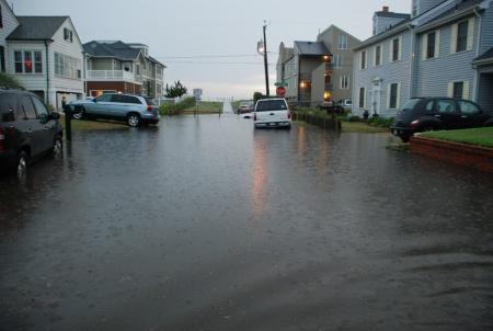
5 Community Issues

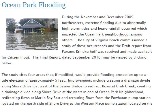


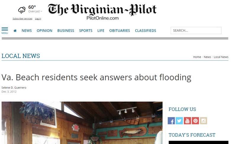
6 Flood Complaints

7 Resiliency Viewpoint Ensure the vibrant future of Virginia Beach Core Strategies:

8 Moody s Questionnaire to VB Does the existing/future CIP include spending for mitigation or resiliency? Has your governing body discussed the capital or financial implications of rising sea levels? Has there been an estimate on potential impacts from rising sea levels or flooding? Please discuss how flooding has impacted the city s budget and how flood mitigation efforts may impact future budgets? Have there been any zoning /long-term planning adjustments downtown and along the waterfront to mitigate future flooding impacts? What is management s current view on the potential impact/vulnerabilities in your community from rising sea levels and a heightened risk of extreme weather events?

9 Proactive Project Design Design policy guidelines SLR and Capital Improvement Projects Adopted Recommendations: Explore additional 1.5 ft of SLR in the design and documentation of infrastructure projects 3 ft for major projects Can accommodation be meaningfully achieved? How is design informed by these conditions?
10 Capital Improvement Plan Stormwater Master Plan Synergized Activities Resilient Planning and Infrastructure Water Quality Sea Level Rise Comp. Study
11 Water Quality Challenges Compliance Issues
 Regulatory compliance NPDES MS4, TMDLs Sea level rise and tidal surge North Landing River Back Bay Capital improvement planning and")
12 Comprehensive Stormwater Master Plan Little Creek Elizabeth River Lynnhaven River Owl Creek Stormwater management and flood mitigation Stormwater quality improvement TMDLs (TN, TP, TSS, bacteria) Regulatory compliance NPDES MS4, TMDLs Sea level rise and tidal surge North Landing River Back Bay Capital improvement planning and funding


13 Comprehensive SLR/Recurrent Flooding Study Flood risk assessment Combined flooding Adaptation strategy formulation Policy and Planning Risk Aggregation Strategy evaluation Feasibility Return on Investment Watershed-based adaptation plans Policy, Comprehensive Plan Capital improvement planning and funding

14 Comprehensive SLR Study Approach

15 Informed Resiliency Planning


16 Phase 1: Impact Assessment How will vulnerability change with increasing flood levels due to SLR? Where will we see the flood footprint expand? How much more frequent will flooding occur? What assets are vulnerable? How will losses change? How will insurance requirements change? What assets are at the highest risk?
17 VB SLR Scenarios Life Cycle Alignment Time Horizon/ Time Period SLR Value Relevance Use Municipal Planning years ft Comprehensive Plan & Outcomes Short end of Commercial and Utility life-cycles Vulnerability assessment Key planning value Basis for evaluation of all adaptation strategies Critical Infrastructure Long-term awareness Adaptive Capacity years ft Utility Infrastructure life-cycle Transportation infrastructure lifecycles Residential structure lifecycles Secondary vulnerability assessment to provide insight into long-term risk Basis for long-term infrastructure decisions Evaluate cost-effectiveness of additional protection for adaptable resilience strategies

18 Selected Scenarios vs Federal Curves 3 ft 1.5 ft Action Evaluate for Adaptive Capacity
19 Assessment Conditions Tidal Future permanent inundation Nuisance Repetitive losses/issues Storm Surge Regulatory, disaster scenarios, economics
20 Hazard Evaluation Process Flood Stillwater Surfaces Combined Flooding Floodplain Delineation Depth Grids Total Flood Elevation Surface Wave Hazard Modeling Evaluation/ Summarization Exposure/Risk Analyses

21 Long-term Changes in Surge Propagation

22 Combined Flood Conditions

23 Bringing together the elements Coastal Flooding Stormwater Conveyance Combined Flooding

 Structure Flood Depths")


24 Results: Existing Condition 10-yr coastal surge/10-yr 24-hr duration rainfall Change in Flood Exposure (mi 2 ) Structure Flood Depths Coastal Only = 1.25 Combined Flooding = 1.56 Difference = 0.31 Change in Building Exposure Coastal Only = 277 Combined Flooding = 957 Difference = 680

25 Sensitivity of Loss Analysis
26 Risk Assessment Focus Areas: Shoreline/Land Vulnerability Building Exposure Future Development Stormwater Groundwater Roads Public Utilities Agricultural Societal
27 Building Loss Model Hazus FEMA-backed Nationally applicable standardized methodology Loss models for estimation of earthquakes, floods and hurricanes GIS-based Hazus Flood Module Building-level loss analysis Isolate specific recurrence intervals Annualized loss


28 Hazus - Levels of Analyses Building-level Risk Assessments Other Specific Updates: Essential Facilities Roadway Bridges Primary Utility Features General Building Stock Update from Building-level Information Input Detailed Engineering / Hazard Data Level 3 Combinations of local and default hazard, building, and damage data Level 2 Default hazard, inventory, and damage information Level 1


29 Loss Estimation Process Flood Hazard Data Data Improvement Model Built Environment Perform Damage/Loss Estimation Assign Depth Damage Function Summarize Results Evaluate Economic and Social Impacts
30 Building Data Improvement Cost/Valuation adjustments Inflation Quality Garage sq ft Data gap filling across multiple attributes via web-based mapping resources, neighborhood trends Occupancy type cross-referencing Foundation/construction type standardization/verification Proper breakout of multi-family homes Commercial type ID via Google API First Floor Heights assignment through on multiple sources, gaps filled with validated linear regression-based equation
31 First Floor Height Regression Analyses General form of Multi-Variable Linear Regression: FFH = X 0 + a 1 X 1 + a 2 X a N X N Predictor Variables: Occupancy(x1), Year Built(x2), Foundation Type(x3) and Grade Difference (x4) Two sets of equations, based on year built: Prior to 2004: FFFFFF iiii ffffffff 0.96 iiii RRRRRRR = iiii RRRRRRRRR XX iiii RRRRRRRRR XX1 On or after 2004: FFFFFF iiii ffffffff = iiii RRRRRRR XX iiii PPPPPPPP 0.39 iiii CCCCCCCCCCCCCCCCCCCC XX XX iiii PPPPPPPP 1.31 iiii CCCCCCCCCCCCCCCCCCCC XX XX 4
32 First Floor Height Error Improvements ERROR STATISTICS Avg error drop: 32% Largest drop for Pile foundations: 46%
33 Hazus Flood Loss Outputs Direct Economic Losses Square Footage Damage % Damage Counts of Damaged Structures Total Loss Building Loss Contents Loss Inventory Loss Relocation Cost Income Loss Rental Income Loss Wage Loss Direct Output Loss Employment Loss Building Type Vehicle Damage and Loss Debris Generation Displaced Population and Short Term Needs
34 Hazus Flood Loss Outputs Indirect Economic Losses for Income & Employment within the following Market Sectors: Agriculture Mining Construction Manufacturing Transportation Trade Finance Services Government Miscellaneous TOTAL

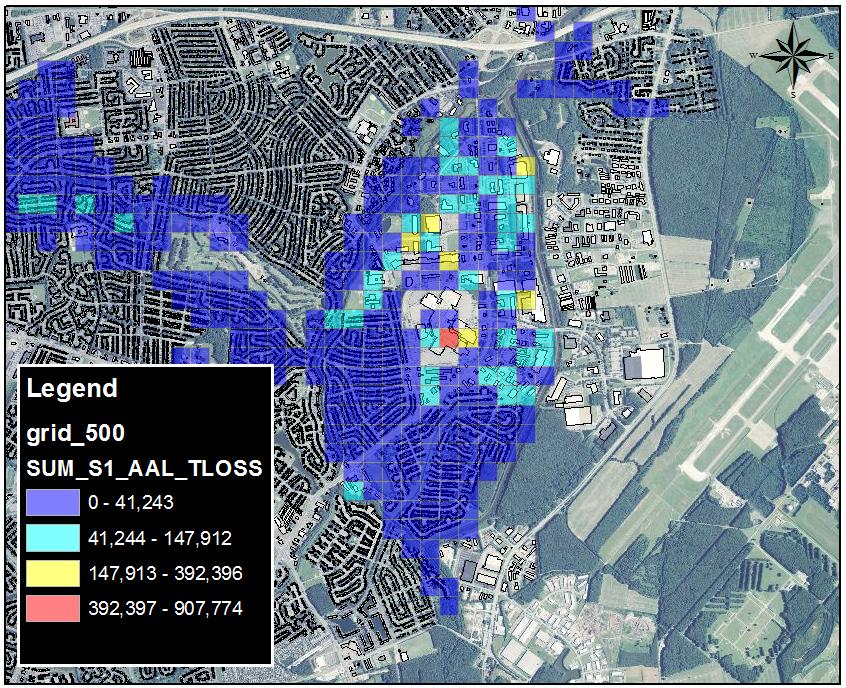
35 Loss Changes from Today to 1.5 ft SLR Fold Increase Over Today 10 Year 25 Year 50 Year 100 Year 500 Year AAL
36 Insurance Economic Analysis Current Conditions: Policy/claim concentration Under-insurance issues on current policies in force Future Conditions & Regulatory Changes: Changes to insurance liabilities and residual risks Identify and prioritize mitigation of high risk assets Promotion of increased flood insurance penetration outside existing SFHA Flood Insurance Affordability: Cost burden of flood insurance to socio-economic vulnerable areas


37 Geographic Conflation Framework


38 Geographic Units Low Moderate-Low Low Low Low Moderate-High Moderate-Low Moderate-Low Moderate-Low High Moderate-High Moderate-High Moderate-High High High High


39 Loss Change Summarization Existing Condition 1.5 ft SLR Low Mild Moderate High Severe Low Mild Moderate High Severe

40 Distribution and Magnitude of Loss
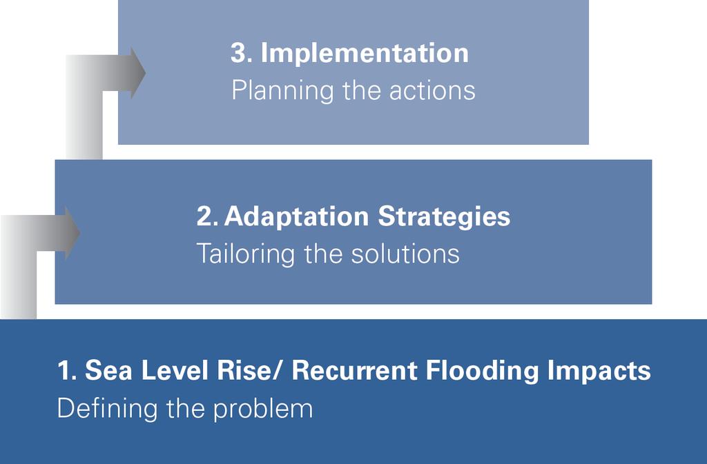
41 Phase 2: Adaptation Strategies Objective: Develop, assess and prioritize a range of adaptation strategies through feasibility and performance metrics that incorporate stakeholder input to inform climate adaptation and resilience plans across the City s diverse geography. What strategies are needed to address the risk portfolio? What policy has to be created or changed? How can land use be managed? Where do structural solutions make sense? What s the return on investment? What strategies work best? When should implementation occur?
42 Environmental, Economic Diversity
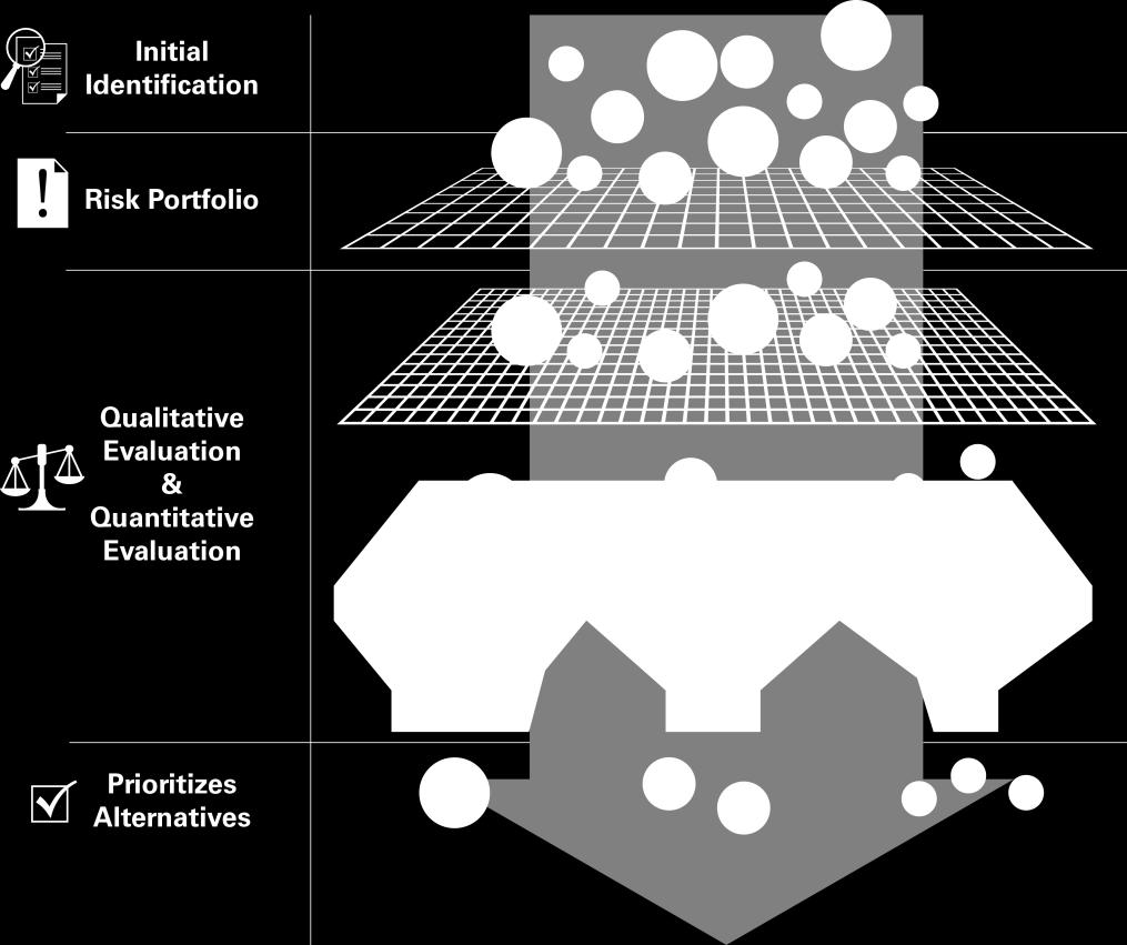
43


44 Adaptation Tools


45 Phase 3: Implementation Objective: Integrate the best-performing adaptation strategies in actionable watershed-based climate adaptation and resilience plans that include funding and monitoring mechanisms to stimulate follow-on implementation. How do we move forward with the preferred solutions? What are the costs and design features? How do we fund? What is our action plan for each watershed? How do we get public buy-in, sponsors, and/or regional support?
46 Outreach - Integration Engage Coordinate Leverage Partners: HRPDC ODU/Virginia Sea Grant Georgetown Climate Center

47 Questions? Points of Contact: City of Virginia Beach Department of Public Works Greg Johnson, P.E Shanda Davenport, P.E., CFM, AICP Dewberry Brian Batten, Ph.D., CFM
Vision to Action: Creating and Using a Flood Risk Assessment for Identifying Mitigation Options
 Vision to Action: Creating and Using a Flood Risk Assessment for Identifying Mitigation Options Lisa Graff, CFM, GISP Clayton Ballerine, CFM Brad McVay, CFM, GISP University of Illinois Prairie Research
Kentucky Risk MAP It s not Map Mod II
 Kentucky Risk MAP It s not Map Mod II Risk Mapping Assessment and Planning Carey Johnson Kentucky Division of Water carey.johnson@ky.gov What is Risk MAP? Risk Mapping, Assessment, and Planning (Risk MAP)
Non Regulatory Risk MAP Products Flood Depth and Probability Grids
 Non Regulatory Risk MAP Products Flood Depth and Probability Grids Virginia Floodplain Management Association 2015 Floodplain Management Workshop October 29th, 2015 Nabil Ghalayini, P.E., PMP, D.WRE, CFM
Flood Risk Products. New Techniques for Identifying and Communicating Flood Risk
 Flood Risk Products New Techniques for Identifying and Communicating Flood Risk Mark Zito, GISP, CFM GIS Specialist Amol Daxikar, GISP, CFM Project Manager March 28, 2012 1% Flood with 3 Feet Sea Level
New Tools for Mitigation & Outreach. Louie Greenwell Stantec
 New Tools for Mitigation & Outreach Louie Greenwell Stantec Our Discussion Today Background What is Risk MAP? FEMA Products Overview of RiskMAP Data Sets Changes Since Last FIRM Depth and Analysis Grids
Michael Taylor, PE, CFM Project Manager, AECOM August 25, 2015
 Promoting FEMA s Flood Risk Products in the Lower Levisa Watershed Michael Taylor, PE, CFM Project Manager, AECOM August 25, 2015 Agenda Study Background Flood Risk Product Overview AOMI and Mitigation
Use of FEMA Non regulatory Flood Risk Products in Planning
 Use of FEMA Non regulatory Flood Risk Products in Planning Georgia Association of Floodplain Managers Annual Conference March 24, 2016 What are the Non regulatory Flood Risk products? Go beyond the basic
Adaptation Practices and Lessons Learned
 Adaptation Practices and Lessons Learned Increased Flooding Risk Due To Sea Level Rise in Hampton Roads: A Forum to Address Concerns, Best Practices and Plans for Adaptation Nov. 16, 2012 Virginia Modeling,
Norfolk Flood Risk Management Study
 Old Dominion University ODU Digital Commons May 18, 2016: The Economic Impacts of Sea-Level Rise in Hampton Roads Hampton Roads Intergovernmental Pilot Project: Meetings 5-18-2016 Norfolk Flood Risk Management
National Capitol Region HAZUS User Group Call
 Listen to the recording here to follow along with the presentation: http://www.freeconferencecalling.com/recordings/recording.aspx?fileid=l AF3494_04252013070630062_1154707&bridge=697620&email=&account
G318 Local Mitigation Planning Workshop. Module 2: Risk Assessment. Visual 2.0
 G318 Local Mitigation Planning Workshop Module 2: Risk Assessment Visual 2.0 Unit 1 Risk Assessment Visual 2.1 Risk Assessment Process that collects information and assigns values to risks to: Identify
Aquidneck Island Resilience Strategy Issue Paper 4. Issue: RESIDENTIAL FLOODING
 Aquidneck Island Resilience Strategy Issue Paper 4 Issue: RESIDENTIAL FLOODING Description of Concern: While much of Aquidneck Island s geography lies outside the reach of coastal flooding, some of the
Sea Level Rise and the NFIP
 Cheryl A Johnson, PE, CFM, PMP March 26, 2014 http://www.globalchange.gov/ Sea-level rise and the likely increase in hurricane intensity and associated storm surge will be among the most serious consequences
Flood Risk Assessment in the
 Georgia Flood M.A.P. Program Flood Risk Assessment in the Upper Chattahoochee h h River Basin GAFM Annual Conference March 28, 2012 Agenda Map Mod to Risk MAP (Georgia Flood M.A.P.) transition Flood Risk
Emergency Management. December 16, 2010
 Applications of Hazus-MH for Emergency Management December 16, 2010 What is Hazus-MH? Free ArcGIS extension Facilitates a risk-based approach to mitigation Identifies and visually displays hazards and
Leveraging HAZUS for Risk Assessment Analysis within Risk MAP
 Leveraging HAZUS for Risk Assessment Analysis within Risk MAP Jen Meyer - FEMA Region X Shane Parson - RAMPP PTS Team (URS Corp.) 2010 HAZUS Conference - August 2010 The Paradigm Shift: Map Mod to Risk
DuPage County East Branch DuPage River Resiliency Project. Benefit Cost Analysis
 DuPage County East Branch DuPage River Resiliency Project Benefit Cost Analysis 1.0 Benefit Cost Analysis Preparation The BCA for this proposal was a collaborative effort between DuPage County, V3 engineering
Talk Components. Wharton Risk Center & Research Context TC Flood Research Approach Freshwater Flood Main Results
 Dr. Jeffrey Czajkowski (jczaj@wharton.upenn.edu) Willis Research Network Autumn Seminar November 1, 2017 Talk Components Wharton Risk Center & Research Context TC Flood Research Approach Freshwater Flood
Accounting for Long-Term Erosion and Sea Level Rise in New England: A TMAC Recommendation
 Accounting for Long-Term Erosion and Sea Level Rise in New England: A TMAC Recommendation Elena Drei-Horgan, PhD, CFM Jeremy Mull, PE Brian Caufield, PE May 2017 Establishment of TMAC, Definition, Members
Crediting Adaptation Strategies through the National Flood Insurance Program s Community Rating System Coordinator s Manual
 Crediting Adaptation Strategies through the National Flood Insurance Program s Community Rating System Coordinator s Manual W. Thomas Hawkins, Adjunct Faculty, University of Florida, Levin College of Law
The Citadel. Multi-Hazard Mitigation Disaster Resistant University Plan
 The Citadel Multi-Hazard Mitigation Disaster Resistant University Plan Project Objective To Develop a Disaster Resistant University Hazard Mitigation Plan Identify Hazards Profile Hazards Inventory Assets
INSURANCE AFFORDABILITY A MECHANISM FOR CONSISTENT INDUSTRY & GOVERNMENT COLLABORATION PROPERTY EXPOSURE & RESILIENCE PROGRAM
 INSURANCE AFFORDABILITY A MECHANISM FOR CONSISTENT INDUSTRY & GOVERNMENT COLLABORATION PROPERTY EXPOSURE & RESILIENCE PROGRAM Davies T 1, Bray S 1, Sullivan, K 2 1 Edge Environment 2 Insurance Council
Volusia County Floodplain Management Plan 2012
 Volusia County Floodplain Management Plan 2012 Introduction The National Flood Insurance Program (NFIP) provides federally supported flood insurance in communities that regulate development in floodplains.
Location: Tampa, Florida March 6, 2013
 Discovery Meeting: West Florida Coastal Study Location: Tampa, Florida March 6, 2013 Agenda Introductions Why we are here Outline Risk MAP products and datasets Discovery Overview: Project scoping and
VULNERABILITY ASSESSMENT
 SOUTHSIDE HAMPTON ROADS HAZARD MITIGATION PLAN VULNERABILITY ASSESSMENT INTRODUCTION The Vulnerability Assessment section builds upon the information provided in the Hazard Identification and Analysis
Modernization, FEMA is Recognizing the connection between damage reduction and
 EXECUTIVE SUMMARY Every year, devastating floods impact the Nation by taking lives and damaging homes, businesses, public infrastructure, and other property. This damage could be reduced significantly
Integrating Hazus into the Flood Risk Assessment
 Integrating Hazus into the Flood Risk Assessment GAFM Conference, March 22, 2016 Mapping Assessment Planning Agenda What is Hazus & Risk Assessment? Census Block vs. Site Specific Analysis User Defined
Discovery Meeting: Middle Potomac- Catoctin Watershed. FEMA REGION III September 26, 2012 Rockville, MD and Fairfax, VA
 Discovery Meeting: Middle Potomac- Catoctin Watershed FEMA REGION III September 26, 2012 Rockville, MD and Fairfax, VA Agenda Introductions Purpose of This Meeting Discovery Process Community Rating System
2015 AWRA Summer Specialty Conference: Climate Change Adaptation (New Orleans, LA) June 15, 2015 Presenter: John Squerciati, P.E.
 June 15, 2015 Presenter: John Squerciati, P.E.") Economic Assessment Tools for Infrastructure Resilience Projects - FTA - Hazard Mitigation Cost Effectiveness (HMCE) Tool and Recurrence Interval Calculator for Benefit-Cost Analysis 2015 AWRA Summer Specialty
Economic Assessment Tools for Infrastructure Resilience Projects - FTA - Hazard Mitigation Cost Effectiveness (HMCE) Tool and Recurrence Interval Calculator for Benefit-Cost Analysis 2015 AWRA Summer Specialty
Bucks County, PA Flood Risk Review Meeting. November 2014
 Bucks County, PA Flood Risk Review Meeting November 2014 Agenda for Today Risk MAP Program overview Overview of non-regulatory Flood Risk Products and datasets Discuss mitigation action Technical overview
Thurston County, WA Flood Hazard Mitigation Plan Annual Progress Report CRS Activity 510
 Thurston County, WA Flood Hazard Mitigation Plan Annual Progress Report CRS Activity 510 Reporting Period: ctober 1, 2014 to September 30, 2015 Background: Thurston County developed a flood hazard mitigation
Survey of Hazus-MH: FEMA s Tool for Natural Hazard Loss Estimation
 Survey of Hazus-MH: FEMA s Tool for Natural Hazard Loss Estimation What is Hazus? Software tools and support system designed by FEMA for the purpose of providing communities with the means to identify
Implementing risk-based asset management strategies
 Implementing risk-based asset management strategies 2018. 04. 17 Disaster Resilience by Design The challenge for local governments The Challenge for Local Governments Landslides Debris Flows Wildfire Wind
Role of Disaster Insurance in Improving Resilience: An Expert Meeting The Resilient America Roundtable
 Role of Disaster Insurance in Improving Resilience: An Expert Meeting The Resilient America Roundtable National Academy of Science Washington, DC July 9, 2015 Roseville Demographics Primary population
Coastal Vulnerability Assessment and Adaptation Plan CITY OF CLEARWATER
 Coastal Vulnerability Assessment and Adaptation Plan 1 Background Vulnerability Assessment Adaptation Plan Peril of Flood Grant 2 Background SEA LEVEL RISE ADAPTATION PROJECT This publication was funded
FEMA FLOOD MAPS Public Works Department Stormwater Management Division March 6, 2018
 FEMA FLOOD MAPS Public Works Department Stormwater Management Division March 6, 2018 Presentation Overview FEMA National Flood Insurance Program (NFIP) FEMA Community Rating System (CRS) Flood Insurance
City of Pensacola and Escambia County Flood Risk and Flood Insurance Study
 City of Pensacola and Escambia County Flood Risk and Flood Insurance Study Preliminary Report 1: Long Hollow and Sanders Beach Tracts Wharton Risk Management and Decision Processes Center November 8, 2016
ADVISORY BASE FLOOD ELEVATIONS (ABFEs)
") The Department of Homeland Security s Federal Emergency Management Agency is committed to helping communities that were impacted by Hurricanes Katrina and Rita rebuild safer and stronger. Following catastrophic
The Department of Homeland Security s Federal Emergency Management Agency is committed to helping communities that were impacted by Hurricanes Katrina and Rita rebuild safer and stronger. Following catastrophic
Mapping Flood Risk in the Upper Fox River Basin:
 Mapping Flood Risk in the Upper Fox River Basin: Vulnerable Populations and Adverse Health Effects Presented by: Angelina Hanson STUDY AREA: Wisconsin's Upper Fox River Basin Total Population 139,309.
Not Your Average Risk Assessment: Multi-Stage Risk Assessments for Sites in the Passaic River Basin Stuart Geiger, CFM Joseph Ruggeri, PE, CFM
 Not Your Average Risk Assessment: Multi-Stage Risk Assessments for Sites in the Passaic River Basin Stuart Geiger, CFM Joseph Ruggeri, PE, CFM Agenda Project Background Risk Assessment Development Refined
Evaluating the Effectiveness of the Community Rating System: A Comparative Analysis
 Evaluating the Effectiveness of the Community Rating System: A Comparative Analysis (and other CRS related tidbits) Wesley E. Highfield & Samuel D. Brody Center for Texas Beaches & Shores Department of
NATIONAL FLOOD INSURANCE REFORM AS A TOOL FOR MUNICIPAL CLIMATE RESILIENCE ENHANCEMENT
 NATIONAL FLOOD INSURANCE REFORM AS A TOOL FOR MUNICIPAL CLIMATE RESILIENCE ENHANCEMENT APRIL 22, 2016 RESILIENCE AND THE BIG PICTURE SYMPOSIUM UNIVERSITY OF CONNECTICUT SCHOOL OF LAW JOHN RYAN-HENRY CANDIDATE,
The COAST Approach to Adaptation Action for Sea Level Rise and Storm Surge. Samuel B. Merrill, PhD May 20, 2014
 The COAST Approach to Adaptation Action for Sea Level Rise and Storm Surge Samuel B. Merrill, PhD May 20, 2014 Fig. 3c-City of Portland: Commercial Street EastCOAST Model Results, 100 Year Storm in 2100
Pricing storm surge risks in Florida: Implications for determining flood insurance premiums and evaluating mitigation measures
 Pricing storm surge risks in Florida: Implications for determining flood insurance premiums and evaluating mitigation measures Marilyn Montgomery Postdoctoral Fellow, Wharton Risk Center, University of
NFIP Program Basics. KAMM Regional Training
 NFIP Program Basics KAMM Regional Training Floodplain 101 Homeowners insurance does not cover flood damage Approximately 25,000 flood insurance policies in KY According to BW12 analysis, approximately
Avon. Challenges. Estimated Damages from 100- Year Flood
 Avon Avon is a suburban town in north-central Connecticut with a population of about 18,000. It has an average elevation of about 350 ft. The Town encompasses 23.5 square miles, lying entirely within the
Georgia Flood M.A.P. Program
 Georgia Flood M.A.P. Program Georgia Flood M.A.P. Program The Upper Chattahoochee River Basin Risk MAP Project Transitioning State Program to align with FEMA s Risk MAP Program Increase focus on risk assessment
Climate Change Adaptation Plan for Choiseul Bay Township, Solomon Islands
 Climate Change Adaptation Plan for Choiseul Bay Township, Solomon Islands Dr Philip Haines and Ms Shannon McGuire Sustainable Engineering Society - Technical Session 17 March 2015 1 Presentation outline
ANNEX B: TOWN OF BLUE RIVER
 ANNEX B: TOWN OF BLUE RIVER B.1 Community Profile Figure B.1 shows a map of the Town of Blue River and its location within Summit County. Figure B.1. Map of Blue River Summit County (Blue River) Annex
Pricing storm surge risks in Florida: Implications for determining flood insurance premiums and evaluating mitigation measures
 Pricing storm surge risks in Florida: Implications for determining flood insurance premiums and evaluating mitigation measures Marilyn Montgomery Postdoctoral Fellow, Wharton Risk Center, University of
REQUEST FOR PROPOSALS. Planning in Water s Way: Flood Resilient Economic Development Strategy for the I-86 Innovation Corridor
 REQUEST FOR PROPOSALS Planning in Water s Way: Flood Resilient Economic Development Strategy for the I-86 Innovation Corridor Southern Tier Central Regional Planning and Development Board (STC) is seeking
Public Meeting Impact of Hurricane Irma on Central Beach
 Public Meeting Impact of Hurricane Irma on Central Beach CITY OF NEW SMYRNA BEACH October 11, 2017 at 6:00 pm Presentation Outline Hurricane Irma Impacts Flooding Caused by Hurricane Irma Original Goals
Kevin Wagner Maryland Department of the Environment
 Kevin Wagner Maryland Department of the Environment Topics Overview of the National Flood Insurance Program (NFIP) Mapping Regulations Insurance Mitigation Community Rating System (CRS) Questions Know
Best Practices. for Incorporating Building Science Guidance into Community Risk MAP Implementation November 2012
 Best Practices for Incorporating Building Science Guidance into Community Risk MAP Implementation November 2012 Federal Emergency Management Agency Department of Homeland Security 500 C Street, SW Washington,
Updates to Maine Coastal Flood Insurance Rate Maps (FIRM s): What a Local Official Should Know. Presented by: Steve Johnson, P.E.
: What a Local Official Should Know. Presented by: Steve Johnson, P.E.") Updates to Maine Coastal Flood Insurance Rate Maps (FIRM s): What a Local Official Should Know Presented by: Steve Johnson, P.E. Town Engineer October 4, 2018 Introduction Federal Emergency Management
Updates to Maine Coastal Flood Insurance Rate Maps (FIRM s): What a Local Official Should Know Presented by: Steve Johnson, P.E. Town Engineer October 4, 2018 Introduction Federal Emergency Management
A GUIDE TO BEST PRACTICE IN FLOOD RISK MANAGEMENT IN AUSTRALIA
 A GUIDE TO BEST PRACTICE IN FLOOD RISK MANAGEMENT IN AUSTRALIA McLuckie D. For the National Flood Risk Advisory Group duncan.mcluckie@environment.nsw.gov.au Introduction Flooding is a natural phenomenon
Moving Policy and Practice from Flood and Coastal Storm Damage Reduction to Risk Management
 Moving Policy and Practice from Flood and Coastal Storm Damage Reduction to Risk Management and other words of encouragement for my friends in the Planning CoP Eric Halpin, PE Special Assistant for Dam
Delaware Bay / River Coastal Flood Risk Study. FEMA REGION II and III September 19, 2012
 Delaware Bay / River Coastal Flood Risk Study FEMA REGION II and III September 19, 2012 Agenda Risk MAP Program Overview Risk MAP Non-Regulatory Products & Datasets Region II New Jersey Coastal Flood Study
Simsbury. Challenges Capitol Region Natural Hazards Mitigation Plan Update - Page 356
 Simsbury Simsbury is a suburban community of about 23,600 located in the western portion of the Capitol Region. Its land area encompasses 33.9 square miles. Elevation in town generally ranges from about
GAFM Showcase: Multiple Agencies Combating Georgia s Flood Risk Together: Proven Results Gained by Strong Partnerships
 National Flood Insurance Program Participation GAFM Showcase: Multiple Agencies Combating Georgia s Flood Risk Together: Proven Results Gained by Strong Partnerships Moderator: Jill Bazinet, PE, CFM GAFM
RISK, RISK BASED DECISION MAKING, AND RISK ANALYSIS
 RISK, RISK BASED DECISION MAKING, AND RISK ANALYSIS Katie Jagt, PE Civil And Environmental Engineer Fulbright Fellow Walsh Environmental January 28, 2014 CSRN Risk and BOK Risk What is Risk? Societal Risk
National Institute of Building Sciences
 National Institute of Building Sciences Provider Number: G168 Improving the Flood Resistance of Buildings and Mitigation Techniques WE3B Peter Spanos, P.E., CFM, LEED AP (Gale Associates, Inc.) Stuart
Georgia Flood M.A.P. Program Risk MAP Plenary Session GAFM 2011
 Georgia Flood M.A.P. Program Risk MAP Plenary Session GAFM 2011 Collis Brown, Georgia DNR March 24, 2011 GA Flood Map Modernization Responsible for end-to-end production Developed aggressive outreach program
Key Policy Issues for the General Insurance Industry
 16 th General Insurance Seminar Coolum, November 10 2008 Key Policy Issues for the General Insurance Industry Kerrie Kelly Executive Director & CEO Insurance Council of Australia Insurance Council of Australia
National Capitol Region HAZUS User Group Call
 Click here to listen to the audio. National Capitol Region HAZUS User Group Call June 28, 2017 11:00 AM ET NCR HUG Call Details Conference Call Details: 1. Dial-in: 1-712-770-8023 2. Conference code: 926757
Adapting Maine s coastal communities to sea level rise and storm surge (2015 State of the Bay Presentation)
") University of Southern Maine USM Digital Commons Presentations Casco Bay Estuary Partnership (CBEP) 2015 Adapting Maine s coastal communities to sea level rise and storm surge (2015 State of the Bay Presentation)
University of Southern Maine USM Digital Commons Presentations Casco Bay Estuary Partnership (CBEP) 2015 Adapting Maine s coastal communities to sea level rise and storm surge (2015 State of the Bay Presentation)
FLOOD HAZARD AND RISK MANAGEMENT UTILIZING HYDRAULIC MODELING AND GIS TECHNOLOGIES IN URBAN ENVIRONMENT
 Proceedings of the 14 th International Conference on Environmental Science and Technology Rhodes, Greece, 3-5 September 2015 FLOOD HAZARD AND RISK MANAGEMENT UTILIZING HYDRAULIC MODELING AND GIS TECHNOLOGIES
SESSION 5C FLOODPLAIN ISSUES 1
 SESSION 5C FLOODPLAIN ISSUES 1 159 NFIP LEGISLATION IMPLEMENTATION UPDATE Richard J. Sobota, 1 CFM, CPCU, FEMA/DHS Both the Biggert-Waters Flood Insurance Reform Act of 2012 and the Homeowner Flood Insurance
BRANDI GABBARD CHAIR, NATIONAL ASSOCIATION OF REALTORS INSURANCE COMMITTEE COUNCIL MEMBER, CITY OF ST. PETERSBURG, FL
 BUILDING CLIMATE RESILIENCE IN THE REAL ESTATE SECTOR BRANDI GABBARD CHAIR, NATIONAL ASSOCIATION OF REALTORS INSURANCE COMMITTEE COUNCIL MEMBER, CITY OF ST. PETERSBURG, FL RESILIENCY THE ABILITY TO PREPARE
The AIR Inland Flood Model for Great Britian
 The AIR Inland Flood Model for Great Britian The year 212 was the UK s second wettest since recordkeeping began only 6.6 mm shy of the record set in 2. In 27, the UK experienced its wettest summer, which
RESILIENT INFRASTRUCTURE June 1 4, 2016
 RESILIENT INFRASTRUCTURE June 1 4, 2016 MUNICIPAL RISK ASSESSMENT TOOL (MRAT) Scott Praill Dillon Consulting Limited, Canada ABSTRACT MRAT is a made-in-canada tool that overlays municipal data sets and
ASFPM RECOMMENDED TASK FORCE ACTIONS
 Association of State Floodplain Managers, Inc. 2809 Fish Hatchery Road, Suite 204, Madison, WI 53713 Phone: 608-274-0123 Fax: 608-274-0696 Website: www.floods.org Email: asfpm@floods.org Federal Interagency
Community Incentives for Nature-Based Flood Solutions
 Community Incentives for Nature-Based Flood Solutions A GUIDE TO FEMA S COMMUNITY RATING SYSTEM FOR CONSERVATION PRACTITIONERS The Federal Emergency Management Agency (FEMA) uses a Community Rating System
Sandy + BW-12: Changing the Equation for Building Safer, More Resilient Communities
 Sandy + BW-12: Changing the Equation for Building Safer, More Resilient Communities Grant Smith Jerry Sparks Jean Huang Ken Logsdon Stephanie Routh Session Agenda Moderators: Grant Smith & Jerry Sparks
SECTION V THE LOCAL MITIGATION STRATEGY BLUEPRINT
 SECTION V THE LOCAL MITIGATION STRATEGY BLUEPRINT A. GUIDING MITIGATION PRINCIPLES The Local Mitigation Strategy (LMS) is Hillsborough County s program developed to reduce or eliminate all forms of losses
CITY OF PLANTATION ENGINEERING DEPARTMENT INTEROFFICE MEMORANDUM NO
 CITY OF PLANTATION ENGINEERING DEPARTMENT INTEROFFICE MEMORANDUM NO. 2013-003 DATE: October 22, 2012 TO: Mayor and Members of City Council FROM: Brett W. Butler, PE, CFM City Engineer SUBJECT: CRS Program
Delaware River Basin Commission s Role in Flood Loss Reduction Efforts
 Delaware River Basin Commission s Role in Flood Loss Reduction Efforts There is a strong need to reduce flood vulnerability and damages in the Delaware River Basin. This paper presents the ongoing role
Risk, Mitigation, & Planning
 Risk, Mitigation, & Planning Lessons from Flooding in the Houston Area Russell Blessing, Samuel Brody & Wesley Highfield CUMULATIVE FLOOD LOSS: 1972-2015 INSURED FLOOD LOSS: 1972-2015 THE HOUSTON-GALVESTON
Coastal Flood Insurance Studies in Virginia and Climate Change
 Coastal Flood Insurance Studies in Virginia and Climate Change VFMA Floodplain Management Workshop October 22, 2015 Jeff Gangai Why is a Coastal Restudy Needed? New Guidelines need to be implemented Atlantic
Questions about the National Flood Insurance Program
 Questions about the National Flood Insurance Program Federal Emergency Management Agency (FEMA) Questions and Answers What is the National Flood Insurance Program (NFIP)? The NFIP is a Federal program
Findings/Debrief Meeting September 9, CDOT R4 Headquarters Big Thompson Conference Room W 10 th St. Greeley, CO 80634
 Findings/Debrief Meeting September 9, 2016 CDOT R4 Headquarters Big Thompson Conference Room 10601 W 10 th St. Greeley, CO 80634 Discovery Review & Outcome May 25 Discovery Meeting Summary Summarize Data
Town of Montrose Annex
 Town of Montrose Annex Community Profile The Town of Montrose is located in the Southwest quadrant of the County, east of the Town of Primrose, south of the Town of Verona, and west of the Town of Oregon.
HAZARD MITIGATION IN HISTORIC DISTRICTS. Louisette L. Scott AICP, CFM Director, Dept. Planning & Development Mandeville, LA January 31, 2018
 1 HAZARD MITIGATION IN HISTORIC DISTRICTS Louisette L. Scott AICP, CFM Director, Dept. Planning & Development Mandeville, LA January 31, 2018 Mandeville, LA 2 Mandeville is Located on the northshore of
10/5/2015. What Makes a Sound Floodplain Management Program? What are the Flood Problems in your Community?
 The Community Rating System (CRS) and Hazard Mitigation Planning Preparing Your Community Through Common Program Goals September 3, 2015 What Makes a Sound Floodplain Management Program? Know your community
T-318. Hazard Mitigation Section TDEM Recovery, Mitigation, and Standards
 T-318 Local Hazard Mitigation Plan Requirements Hazard Mitigation Section TDEM Recovery, Mitigation, and Standards Raymond Mejia, Lead Hazard Mitigation Planner Samantha Aburto, Hazard Mitigation Planner
A Flood Mitigation Plan for the Non-Tidal N.J. Section of the Delaware River Basin. Mercer County Kick-off Meeting December 6, 2006
 A Flood Mitigation Plan for the Non-Tidal N.J. Section of the Delaware River Basin Mercer County Kick-off Meeting December 6, 2006 The Delaware River. crosses many boundaries Four states: DE, PA, NJ, NY
Community Rating System. National Flood Insurance Program
 National Flood Insurance Program Community Rating System A Local Official s Guide to Saving Lives Preventing Property Damage Reducing the Cost of Flood Insurance FEMA B-573 / May 2015 How the Community
CRISP COUNTY, GEORGIA AND INCORPORATED AREAS
 CRISP COUNTY, GEORGIA AND INCORPORATED AREAS Community Name Community Number ARABI, CITY OF 130514 CORDELE, CITY OF 130214 CRISP COUNTY (UNINCORPORATED AREAS) 130504 Crisp County EFFECTIVE: SEPTEMBER 25,
A Flood Mitigation Plan for the Non-Tidal N.J. Section of the Delaware River Basin. Sussex County Kick-off Meeting November 28, 2006
 A Flood Mitigation Plan for the Non-Tidal N.J. Section of the Delaware River Basin Sussex County Kick-off Meeting November 28, 2006 The Delaware River. crosses many boundaries Four states: DE, PA, NJ,
Comparing HAZUS Flood Loss Estimates Across Hazard Identification Methods and Building Stock Inventory Data. Albion Township Dane County, Wisconsin
 Across Hazard Identification Methods and Building Stock Inventory Data Albion Township Dane County, Wisconsin Prepared for the Association of State Floodplain Managers September 1, 2010 Across Various
A Flood Mitigation Plan for the Non-Tidal N.J. Section of the Delaware River Basin. Warren County Planning Workshop (2 nd Meeting) March 7, 2007
 March 7, 2007") A Flood Mitigation Plan for the Non-Tidal N.J. Section of the Delaware River Basin Warren County Planning Workshop (2 nd Meeting) March 7, 2007 Study Area Participation: Hunterdon: 16 Eligible Municipalities
A Flood Mitigation Plan for the Non-Tidal N.J. Section of the Delaware River Basin Warren County Planning Workshop (2 nd Meeting) March 7, 2007 Study Area Participation: Hunterdon: 16 Eligible Municipalities
Broward County, Florida 100 -Year Flood Elevation Map and Associated Modeling. Bid No. R P1 September 27, 2017
 Broward County, Florida 100 -Year Flood Elevation Map and Associated Modeling Bid No. R2114367P1 September 27, 2017 Meet the AECOM Team 2 Key Team Roles and Responsibilities Key Benefit: AECOM has assembled
2018 FMA Annual Conference in Reno, NV:
 Nevada Floodplain Management News V O L U M E INSIDE THIS ISSUE: Sustainability in 1 the Face of Change Community Rating System Workshop 2 CCRFCD Master Plan Update 3 Douglas Co. Stormwater Maintenance
Welcome to a Silver Jackets Webinar
 Welcome to a Silver Jackets Webinar The CRS and Repetitive Loss Area Analysis (RLAA) For audio, Dial: 877 336-1839 Access code: 5884527 Security code: 4567 Visual 10.1 David A. Stroud, CFM Emergency &
in coordination with Peoria County, Planning and Zoning Department
 Prepared by Amec Foster Wheeler Environment & Infrastructure Hazard Mitigation and Emergency Management Program in coordination with Peoria County, Planning and Zoning Department The purpose of hazard
CONTINUING AUTHORITIES PROJECT (CAP) Federal Interest Determination
 Federal Interest Determination") Date: 8 May 2013 Division: Great Lakes and Ohio River Division District: Nashville District CONTINUING AUTHORITIES PROJECT (CAP) Federal Interest Determination 1. Project: Cumberland River, Metropolitan
Date: 8 May 2013 Division: Great Lakes and Ohio River Division District: Nashville District CONTINUING AUTHORITIES PROJECT (CAP) Federal Interest Determination 1. Project: Cumberland River, Metropolitan
Flood Risk Management and Nonstructural Flood Risk Adaptive Measures
 Flood Risk Management and Nonstructural Flood Risk Adaptive Measures Randall Behm, P.E., CFM USACE-Omaha District Chair, National Nonstructural Flood Proofing Committee US Army Corps of Engineers BUILDING
INFORMED DECISIONS ON CATASTROPHE RISK
 ISSUE BRIEF INFORMED DECISIONS ON CATASTROPHE RISK Analysis of Flood Insurance Protection: The Case of the Rockaway Peninsula in New York City Summer 2013 The Rockaway Peninsula (RP) in New York City was
Flood Risk, Insurance and Integrated Flood Hazard Management
 Canadian Water Resources Association Association Canadienne des Ressources Hydriques Flood Risk, Insurance and Integrated Flood Hazard Management Dave Murray, National President June 8-9, 2016 Window on
4 TH ANNUAL CAPE COASTAL CONFERENCE. Adaptation Planning, Environmental Economics and Community Engagement
 4 TH ANNUAL CAPE COASTAL CONFERENCE THE RESILIENT CAPE COD PROJECT Adaptation Planning, Environmental Economics and Community Engagement K r i s t y S e n a t o r i, Cape Cod Commission NOAA COASTAL RESILIENCY