Risk, Mitigation, & Planning
|
|
|
- Ferdinand Neal
- 6 years ago
- Views:
Transcription
1 Risk, Mitigation, & Planning Lessons from Flooding in the Houston Area Russell Blessing, Samuel Brody & Wesley Highfield
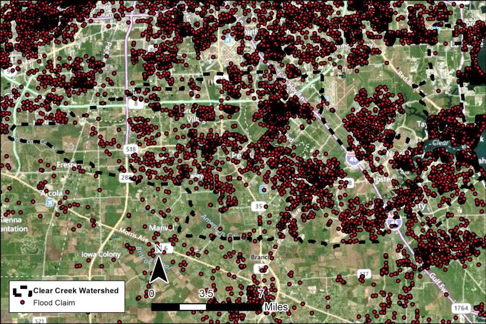
2 CUMULATIVE FLOOD LOSS:


3 INSURED FLOOD LOSS:
4
5
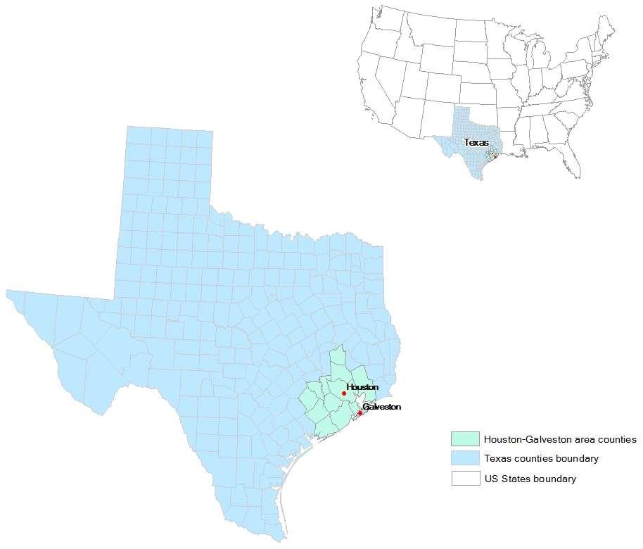
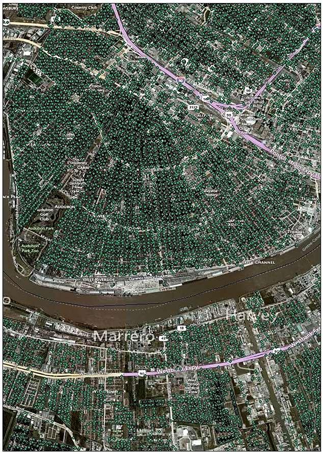
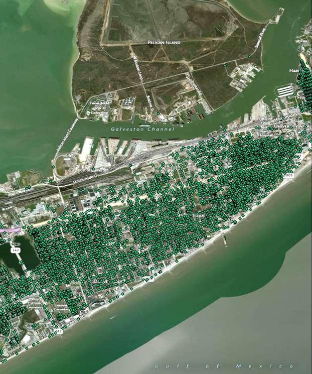
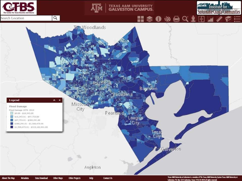
6 THE HOUSTON-GALVESTON REGION
7 Galveston Bay Area Flooding Houston is one of most flood prone cities in U.S. Rapidly moving weather systems result in explosive rainfalls Little topographic relief, clay soils, and impervious surfaces contribute to large volumes of runoff and ponding Low lying coastal areas subject to surge Older homes with little elevation are subject to street flooding Population growth of 3.7 million people is expected in the region by 2040 (annual growth of ~100,000 people)

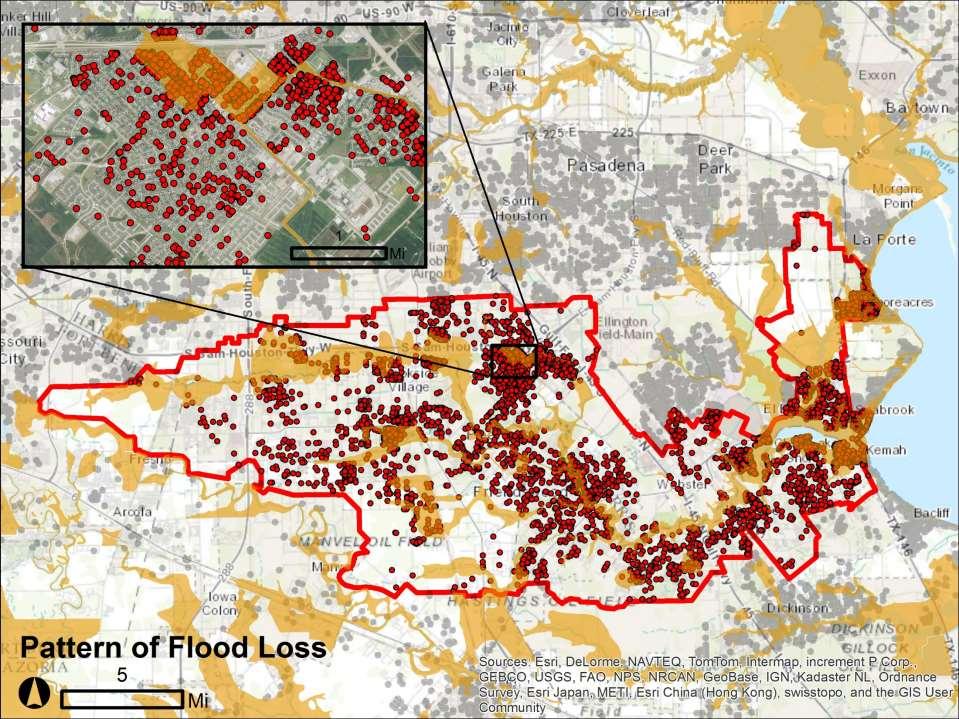
8 Chronic Flooding in Harris County 6/10 of the most flood-damaged coastal zip codes the most flood-related fatalities in the U.S. in the last 50 years 47% of all flood claims ( ) were outside of the 100 year floodplain boundary
9
10
11 An Inadequate Indicator of Risk The FEMA 100-year Floodplain
12 Two-Part Study 1. Examined the characteristics of flood loss occurring outside the floodplain. 2. Identified the drivers of flood loss outside the floodplain.

13
14
15 IMPORTANCE OF PROXIMITY Properties further away from floodplain experience less damage 1 foot = $23.20 decrease in reported damage BUT Living a quarter mile outside the floodplain still leaves an expected loss of $12,972.


16 Drivers of Flood Loss Outside the Floodplain Disconnect b/w floodplains and actual loss Model uncertainty Risk is a gradient The 100-year flood is a moving target Changes in development Changes in storm intensities and frequencies Storm Characteristics Intensity Duration Antecedent rainfall


17 Comparing Models of Flood Risk Can spatially distributed models better capture historical flood damage? 2D fully distributed hydrologic model vs FEMA s 100-year floodplain Land Use/Cover + Soils + Elevation = Vflo TM Model Green and Ampt Parameters: USGS Soil Data Mart & NOAA CCAP 2006


18 Captured Damage Captured Claims Vflo SFHA Vflo SFHA Allison 81.8% 29.8% 76.5% 24.5% Erin 55.6% 13.0% 53.1% 15.3% Ike 31.5% 18.0% 47.7% 7.3% April 68.0% 13.0% 66.7% 12.8% Oct 81.2% 48.9% 69.6% 21.7% Other 38.2% 0.0% 80.0% 0.0% Total 74.2% 25.5% 67.9% 19.9%
19 Two Key Points 1. Changing LULC is a key driver of flood loss outside the 100-year floodplain. 2. Even the most advanced model of flood risk will be undermined by changes in LULC.
20 Mitigating Flood Risk The Community Rating System
21 Two-Part Study 1. Examined the effect of CRS activities at reducing flood losses and insurance premiums. 2. Generated a scenario based cost benefit analysis of CRS avoidance based strategies.

22 Offsetting Rising Premiums Clear Creek Watershed: How much would premiums have increased had HFIAA gone into effect? Average Premium Increase Floodplain All City Inside Outside Manvel - $96 $96 League City $404 $149 $184 Webster $280 $165 $192 Friendswood $456 $213 $257 Alvin $1,560 $156 $284 Brookside Village $363 $245 $292 Pearland $589 $205 $323 Houston $482 $238 $325 Kemah $449 $131 $364 El Lago $558 $258 $373 Seabrook $507 $289 $384 Shoreacres $373 $536 $453 Clear Lake Shores $463 - $463 Nassau Bay $610 $290 $473 Pasadena $513 - $513 La Porte $586 $413 $531 Taylor Lake Village $1,004 $244 $776 Watershed $508 $227 $338
23 Avg Damage Remainaing per Structure The Value of Avoiding Flood Risk How many CRS points required to offset HFIAA premium increases? $2,000 $1,500 Avg Premium Savings $1,000 $500 $0 Average Premium Increase = $338 -$ Additional CRS Points
24 How much can be saved? Activity Mitigation Activity Mean Points Maximum Possible Per Point Total Mean Savings 320 Map Information $140 -$13, Outreach Projects $164 -$13, Hazard Disclosure $324 -$3, Flood Protection Info $873 -$18, Flood Protection Assistance $290 -$8, Floodplain Mapping $518 -$12, Open Space Protection $68 -$6, Higher Reg. Stds $130 -$21, Flood Data Maint $331 -$19, Storm water Management $157 -$9, Floodplain Planning $273 -$13, Acquisition/Relocation $24 -$6, Drainage System Maint $68 -$11,937
25 Avg Damage Remainaing per Structure Avg Premium Savings per Homeowner The Value of Avoiding Flood Risk How much damage would have been avoided? Time Period: : Open Space Preservation 430: Higher Regulatory Standards $40,000 $35,000 $30,000 $25,000 $20,000 $15,000 Activity 420 Activity 430 Avg Premium Savings $2,000 $1,500 $1,000 $500 $10,000 $0 $5,000 $0 -$ Additional CRS Points
26 500 point increase in avoidance based mitigation. Who saves? Those that were: Damaged the most Low-lying & coastal Cities with high development in the floodplain

27 Data Visualization Enables: Outreach Exploration Dynamic story-telling
28 Looking Forward Future Development, Moving Floodplains, & Sea Level Rise

29 Flood risk reduction is a moving target: Storm event characteristics Land Use/Land Cover change Existing mitigation Sea level rise What do regional-scale scenarios of future flood damage look like? Forecast land cover change/development Model the distribution of structures in future scenarios. Estimate future storm surge damages

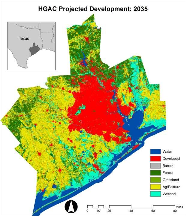
30 Land Cover Data National Land Cover Dataset 30 meter: 2001, 2006, & 2011 Reclassified to improve model accuracy NLCD Developed, Open Space Developed, Low Intensity Developed, Medium Intensity Developed High Intensity Barren Land Deciduous Forest Evergreen Forest Mixed Forest Dwarf Scrub Shrub/Scrub Grassland/Herbaceous Sedge/Herbaceous Pasture/Hay Cultivated Crops Woody Wetlands Emergent Herbaceous Wetlands Open Water Reclassified Developed Barren Forest Grassland Ag/Pasture Wetland Water


31 HISTORICAL CHANGE ANALYSIS Analyze past land cover change Change assessed from 2001 to 2006 sq miles sq miles
32 MODELING DEVELOPMENT PROBABILITIES Change probabilities are developed using an artificial neural networks (ANNs) Can model complex, non-linear relationships between drivers and development Drivers + Transitions ( ) Network of weights formed using an iterative learning process (i.e. training) Variation in model skill forcing all variables to be constant except one Property Values Distance to Coast Percent Employed Distance to All Roads Distance to Developed Distance to Streams Census Place Evidence Likelihood School District Distance to Schools Distance to Downtown Land Cover Evidence Likelihood With all variables

33 True Positive rate Validation Forecast 2011 land cover from 2006 changes Compare with actual 2011 change Soft prediction of 2011 Overlaid on top of what actually changed Relative Operating Characteristic Curve AUC = False Positive rate
34 HGAC Projected Development: 2025 Texas Water Developed Barren Forest Grassland Ag/Pasture 0 Wetland Miles
35
36
37
38
39
40
41 Integrating Future Development and Flood Damage Preliminary back of the envelope estimates Extrapolate residential structure types and counts developed land cover density relationships Re-estimate damage with HAZUS and updated counts ADCIRC inundation layers as inputs Storm surge for 10%/1%/0.02% percent storms and Hurricane Ike Only residential structures
42 Preliminary damage estimates: year surge event: increases damage from ~$500m to ~$700m Existing Future Building Content Total
43 Preliminary damage estimates: year surge event: increases damage from ~$4.3b to ~$8b; Existing Future Building Content Total

44 Preliminary damage estimates: year surge event: increases damage from ~$8b to ~$18.3b; Building Content Total Existing Future

45 Preliminary damage estimates: 2080 A repeat of Hurricane Ike: increases damage from ~$2.97b to $5.33b Existing Future 1 0 Building Content Total
46 Future Work Flood risk is a constantly moving target Higher reg s and floodplain avoidance are cost effective in the face of dynamic risk Visualizing historic losses can be leveraged to improve risk communication More thorough cost-benefit analysis of specific mitigation activities Especially on the cost side In-depth future flood risk assessment over a range of scenarios: Sea level rise into surge models H&H with forecasted land cover change Future floodplain delineations Mitigation scenarios

47 Thank You
Evaluating the Effectiveness of the Community Rating System: A Comparative Analysis
 Evaluating the Effectiveness of the Community Rating System: A Comparative Analysis (and other CRS related tidbits) Wesley E. Highfield & Samuel D. Brody Center for Texas Beaches & Shores Department of
Technical Appendix: Protecting Open Space & Ourselves: Reducing Flood Risk in the Gulf of Mexico Through Strategic Land Conservation
 Technical Appendix: Protecting Open Space & Ourselves: Reducing Flood Risk in the Gulf of Mexico Through Strategic Land Conservation To identify the most effective watersheds for land conservation, we
N Norex Engineering, Inc. O 1220 E. Main Street R League City, TX E Office X Fax
 N Norex Engineering, Inc. O 1220 E. Main Street R League City, TX 77573-4157 E 281-474-2640 Office X 281-474-2748 Fax Harris County September 30, 2013 Public Infrastructure Department Attn: John Blount
GALVESTON COUNTY ECONOMIC RESILIENCE PROFILE
 GALVESTON COUNTY ECONOMIC RESILIENCE PROFILE Contents Galveston Overview...66 Recent Disruptions to the Economy...67 Economic Resilience Strategies...67 Recommendations...67 Land Use and Demographics...68
ASFPM Partnerships for Statewide Mitigation Actions. Alicia Williams GIS and HMP Section Manager, Amec Foster Wheeler June 2016
 ASFPM Partnerships for Statewide Mitigation Actions Alicia Williams GIS and HMP Section Manager, Amec Foster Wheeler June 2016 Summary The Concept Leveraging Existing Data and Partnerships to reduce risk
New Tools for Mitigation & Outreach. Louie Greenwell Stantec
 New Tools for Mitigation & Outreach Louie Greenwell Stantec Our Discussion Today Background What is Risk MAP? FEMA Products Overview of RiskMAP Data Sets Changes Since Last FIRM Depth and Analysis Grids
Modernization, FEMA is Recognizing the connection between damage reduction and
 EXECUTIVE SUMMARY Every year, devastating floods impact the Nation by taking lives and damaging homes, businesses, public infrastructure, and other property. This damage could be reduced significantly
FREQUENTLY ASKED QUESTION ABOUT FLOODPLAINS Michigan Department of Environmental Quality
 FREQUENTLY ASKED QUESTION ABOUT FLOODPLAINS Michigan Department of Environmental Quality WHAT IS A FLOOD? The National Flood Insurance Program defines a flood as a general and temporary condition of partial
Wildfire and Flood Hazards, Using GIS Tools to Assess Risk
 Wildfire and Flood Hazards, Using GIS Tools to Assess Risk Floodplain Management Association Conference, Rancho Mirage, CA September 2015 Thoughts To Keep In Mind What advantages are there in looking at
Non Regulatory Risk MAP Products Flood Depth and Probability Grids
 Non Regulatory Risk MAP Products Flood Depth and Probability Grids Virginia Floodplain Management Association 2015 Floodplain Management Workshop October 29th, 2015 Nabil Ghalayini, P.E., PMP, D.WRE, CFM
Modeling Scenarios for Flood Loss Reduction in Escambia County, FL
 Modeling Scenarios for Flood Loss Reduction in Escambia County, FL Wesley Highfield and Samuel Brody Introduction Increasing physical risk combined with rapid land use change and development in flood-prone
THE $64,000 FLOOD INSURANCE BILL
 THE $64,000 FLOOD INSURANCE BILL GEORGIA ASSOCIATION OF FLOODPLAIN MANAGERS 9 TH ANNUAL TECHNICAL CONFERENCE Patrick Gervais, PE, CFM A CASE STUDY IN FLOOD INSURANCE This is a true story that happened
Sea Level Rise and the NFIP
 Cheryl A Johnson, PE, CFM, PMP March 26, 2014 http://www.globalchange.gov/ Sea-level rise and the likely increase in hurricane intensity and associated storm surge will be among the most serious consequences
Talk Components. Wharton Risk Center & Research Context TC Flood Research Approach Freshwater Flood Main Results
 Dr. Jeffrey Czajkowski (jczaj@wharton.upenn.edu) Willis Research Network Autumn Seminar November 1, 2017 Talk Components Wharton Risk Center & Research Context TC Flood Research Approach Freshwater Flood
Community Rating System. National Flood Insurance Program
 National Flood Insurance Program Community Rating System A Local Official s Guide to Saving Lives Preventing Property Damage Reducing the Cost of Flood Insurance FEMA B-573 / May 2015 How the Community
7. Understand effect of multiple annual exposures e.g., 30-yr period and multiple independent locations yr event over 30 years 3%
 I. FLOOD HAZARD A. Definition 1. Hazard: probability of water height 2. At a Specific XY floodplain location; 3. Z can be expressed as elevation (NAVD88); gauge height; height above ground (depth). 4.
CRS State Profile: Texas
 CRS State Profile: Texas This is a profile for communities in your state that are participating in the Community Rating System (CRS). This profile is intended to provide information to the State NFIP Coordinator
Examine the impact of supply constraints on housing production
 Housing Underproduction in the US: Economic, Fiscal and Environmental Impacts of Enabling Transit-Oriented Smart Growth to Address America s Housing Affordability Challenge Marley Buchman Michael Wilkerson,
Adaptation Practices and Lessons Learned
 Adaptation Practices and Lessons Learned Increased Flooding Risk Due To Sea Level Rise in Hampton Roads: A Forum to Address Concerns, Best Practices and Plans for Adaptation Nov. 16, 2012 Virginia Modeling,
Erie County Flood Risk Review Meeting. January 18, 2018
 Erie County Flood Risk Review Meeting January 18, 2018 Agenda The value of updated flood maps for your community Review updated flood-risk data and important next steps in the Risk MAP process Increasing
Georgia Flood M.A.P. Program
 Georgia Flood M.A.P. Program Georgia Flood M.A.P. Program The Upper Chattahoochee River Basin Risk MAP Project Transitioning State Program to align with FEMA s Risk MAP Program Increase focus on risk assessment
Location: Tampa, Florida March 6, 2013
 Discovery Meeting: West Florida Coastal Study Location: Tampa, Florida March 6, 2013 Agenda Introductions Why we are here Outline Risk MAP products and datasets Discovery Overview: Project scoping and
Overview of Capabilities and Current Limitations
 Overview of Capabilities and Current Limitations Overview of the National Flood Risk Characterization Tool (NFRCT) Map based viewer of relative flood risk around the U.S., with supporting reports for more
GIS - Introduction and Sample Uses
 PDHonline Course L145 (5 PDH) GIS - Introduction and Sample Uses Instructor: Jonathan Terry, P.L.S. 2012 PDH Online PDH Center 5272 Meadow Estates Drive Fairfax, VA 22030-6658 Phone & Fax: 703-988-0088
Mapping Flood Risk in the Upper Fox River Basin:
 Mapping Flood Risk in the Upper Fox River Basin: Vulnerable Populations and Adverse Health Effects Presented by: Angelina Hanson STUDY AREA: Wisconsin's Upper Fox River Basin Total Population 139,309.
Flood Risk Products. New Techniques for Identifying and Communicating Flood Risk
 Flood Risk Products New Techniques for Identifying and Communicating Flood Risk Mark Zito, GISP, CFM GIS Specialist Amol Daxikar, GISP, CFM Project Manager March 28, 2012 1% Flood with 3 Feet Sea Level
Broward County, Florida 100 -Year Flood Elevation Map and Associated Modeling. Bid No. R P1 September 27, 2017
 Broward County, Florida 100 -Year Flood Elevation Map and Associated Modeling Bid No. R2114367P1 September 27, 2017 Meet the AECOM Team 2 Key Team Roles and Responsibilities Key Benefit: AECOM has assembled
Section 19: Basin-Wide Mitigation Action Plans
 Section 19: Basin-Wide Mitigation Action Plans Contents Introduction...19-1 Texas Colorado River Floodplain Coalition Mitigation Actions...19-2 Mitigation Actions...19-9 Introduction This Mitigation Plan,
Use of FEMA Non regulatory Flood Risk Products in Planning
 Use of FEMA Non regulatory Flood Risk Products in Planning Georgia Association of Floodplain Managers Annual Conference March 24, 2016 What are the Non regulatory Flood Risk products? Go beyond the basic
SECTION 9: MAPS AND DATA
 SECTION 9: MAPS AND DATA Contents 9.1. NFIP Maps and Data... 9-2 9.1.1. Adopting and enforcing NFIP floodplain maps and data... 9-2 9.1.2. Adopting and enforcing more restrictive data... 9-2 9.1.3. Annexations...
Best Practices. for Incorporating Building Science Guidance into Community Risk MAP Implementation November 2012
 Best Practices for Incorporating Building Science Guidance into Community Risk MAP Implementation November 2012 Federal Emergency Management Agency Department of Homeland Security 500 C Street, SW Washington,
REAL ESTATE FLOOD DISCLOSURE PROGRAM & FLOOD MAP INFORMATION SERVICES
 REAL ESTATE FLOOD DISCLOSURE PROGRAM & FLOOD MAP INFORMATION SERVICES Agenda 10:30-12:00 Flood Disclosure Program 12:00-12:30 Lunch 12:30-1:30 Flood Map Service Center Lisa Foster, CFM, Floodplain Coordinator
Chapter 5 Floodplain Management
 Chapter 5 Floodplain Management Contents 1.0 Introduction... 1 2.0 Floodplain Management and Regulation... 1 2.1 City Code... 1 2.2 Floodplain Management... 1 2.3 Level of Flood Protection... 2 2.3.1 Standard
Are Risk MAP Products Really on Our Mind?
 Are Risk MAP Products Really on Our Mind? ASFPM 2015 Atlanta, GA Presented By: Jason Wilson, PE, CFM William Fain, EIT, CFM Amec Foster Wheeler Presentation Overview 1. What is Risk MAP/What are Risk Map
REAL ESTATE FLOOD DISCLOSURE PROGRAM & FLOOD MAP INFORMATION SERVICES
 REAL ESTATE FLOOD DISCLOSURE PROGRAM & FLOOD MAP INFORMATION SERVICES Lisa Foster, CFM, Floodplain Coordinator ldfoster@pinellascounty.org January 26, 2018 Why are you here? Save your clients money on
FEMA FLOOD MAPS Public Works Department Stormwater Management Division March 6, 2018
 FEMA FLOOD MAPS Public Works Department Stormwater Management Division March 6, 2018 Presentation Overview FEMA National Flood Insurance Program (NFIP) FEMA Community Rating System (CRS) Flood Insurance
Bucks County, PA Flood Risk Review Meeting. November 2014
 Bucks County, PA Flood Risk Review Meeting November 2014 Agenda for Today Risk MAP Program overview Overview of non-regulatory Flood Risk Products and datasets Discuss mitigation action Technical overview
Southwest Florida Discovery Kick-Off Meeting. February 4, 2014
 Southwest Florida Discovery Kick-Off Meeting February 4, 2014 Agenda Introductions Outline Risk MAP products and datasets Project scoping and schedule Data gathered Next steps Gather stakeholder input/feedback
Michael Taylor, PE, CFM Project Manager, AECOM August 25, 2015
 Promoting FEMA s Flood Risk Products in the Lower Levisa Watershed Michael Taylor, PE, CFM Project Manager, AECOM August 25, 2015 Agenda Study Background Flood Risk Product Overview AOMI and Mitigation
Floodplain Management 101. Mississippi Emergency Management Agency Floodplain Management Bureau
 Floodplain Management 101 Mississippi Emergency Management Agency Floodplain Management Bureau Stafford Act The Stafford Disaster Relief and Emergency Assistance Act (Stafford Act) (Public Law 100-707)
HUD s Environmental Review Process. Disaster Assistance Training 2012 Jerimiah Sanders, Environmental Specialist
 HUD s Environmental Review Process Disaster Assistance Training 2012 Jerimiah Sanders, Environmental Specialist Goals: Understand NEPA Overview of levels of environmental review Spot red flags New Tools
Sandy + BW-12: Changing the Equation for Building Safer, More Resilient Communities
 Sandy + BW-12: Changing the Equation for Building Safer, More Resilient Communities Grant Smith Jerry Sparks Jean Huang Ken Logsdon Stephanie Routh Session Agenda Moderators: Grant Smith & Jerry Sparks
Findings/Debrief Meeting September 9, CDOT R4 Headquarters Big Thompson Conference Room W 10 th St. Greeley, CO 80634
 Findings/Debrief Meeting September 9, 2016 CDOT R4 Headquarters Big Thompson Conference Room 10601 W 10 th St. Greeley, CO 80634 Discovery Review & Outcome May 25 Discovery Meeting Summary Summarize Data
Aquidneck Island Resilience Strategy Issue Paper 4. Issue: RESIDENTIAL FLOODING
 Aquidneck Island Resilience Strategy Issue Paper 4 Issue: RESIDENTIAL FLOODING Description of Concern: While much of Aquidneck Island s geography lies outside the reach of coastal flooding, some of the
ATTACHMENT 1. Amendments to Chapter 18.20, Definitions Area of shallow flooding Area of special flood hazard
 Amendments to Chapter 18.20, Definitions 18.20.206 Area of shallow flooding Area of shallow flooding means a designated AO, or AH, AR/AO, AR/AH, or VO Zone on the a community's flood insurance rate map
Survey of Hazus-MH: FEMA s Tool for Natural Hazard Loss Estimation
 Survey of Hazus-MH: FEMA s Tool for Natural Hazard Loss Estimation What is Hazus? Software tools and support system designed by FEMA for the purpose of providing communities with the means to identify
Moving Policy and Practice from Flood and Coastal Storm Damage Reduction to Risk Management
 Moving Policy and Practice from Flood and Coastal Storm Damage Reduction to Risk Management and other words of encouragement for my friends in the Planning CoP Eric Halpin, PE Special Assistant for Dam
N.C. Floodplain Mapping Program
 N.C. Floodplain Mapping Program Current Status and Update April 23, 2018 NCFMP Program Objectives Purpose: Develop, Maintain, and Disseminate current, accurate, digital flood hazard data for all of NC,
REAL ESTATE FLOOD DISCLOSURE PROGRAM & FLOOD MAP INFORMATION SERVICES
 REAL ESTATE FLOOD DISCLOSURE PROGRAM & FLOOD MAP INFORMATION SERVICES Lisa Foster, CFM, Floodplain Coordinator ldfoster@pinellascounty.org January 26, 2018 Why are you here? Save your clients money on
Comparing HAZUS Flood Loss Estimates Across Hazard Identification Methods and Building Stock Inventory Data. Albion Township Dane County, Wisconsin
 Across Hazard Identification Methods and Building Stock Inventory Data Albion Township Dane County, Wisconsin Prepared for the Association of State Floodplain Managers September 1, 2010 Across Various
The Changing NFIP, the CRS & Local Governments. Scott Pippin, J.D., M.E.P.D.
 The Changing NFIP, the CRS & Local Governments Scott Pippin, J.D., M.E.P.D. Flood Insurance Reform Biggert Waters 2012 (BW12) Homeowner Flood Insurance Affordability Act of 2014 (HFIAA) Bigger Waters 2012
Flood Smart Communities
 Flood Smart Communities Stevie Adams, Freshwater Specialist, The Nature Conservancy Funding provided by NOAA Coastal Storms Program through Ohio Sea Grant To conserve the lands and waters on which all
STORMWATER MANAGEMENT FUND Department of Environmental Services
 Department of Environmental Services Mission: To implement a comprehensive stormwater management program that balances the following goals: 1) to reduce the potential for stormwater threats to public health,
City of St. Augustine. Floodplain Management Higher Standards Information
 City of St. Augustine Floodplain Management Higher Standards Information There are different regulations that communities can use to help protect existing and future development and natural floodplain
Volusia County Floodplain Management Plan 2012
 Volusia County Floodplain Management Plan 2012 Introduction The National Flood Insurance Program (NFIP) provides federally supported flood insurance in communities that regulate development in floodplains.
Flood Risk Assessment in the
 Georgia Flood M.A.P. Program Flood Risk Assessment in the Upper Chattahoochee h h River Basin GAFM Annual Conference March 28, 2012 Agenda Map Mod to Risk MAP (Georgia Flood M.A.P.) transition Flood Risk
GIS - Introduction and Sample Uses
 PDHonline Course L145 (5 PDH) GIS - Introduction and Sample Uses Instructor: Jonathan Terry, P.L.S. 2012 PDH Online PDH Center 5272 Meadow Estates Drive Fairfax, VA 22030-6658 Phone & Fax: 703-988-0088
The AIR Inland Flood Model for Great Britian
 The AIR Inland Flood Model for Great Britian The year 212 was the UK s second wettest since recordkeeping began only 6.6 mm shy of the record set in 2. In 27, the UK experienced its wettest summer, which
Canada s exposure to flood risk. Who is affected, where are they located, and what is at stake
 Canada s exposure to flood risk Who is affected, where are they located, and what is at stake Why a flood model for Canada? Catastrophic losses Insurance industry Federal government Average industry CAT
Integrating Hazus into the Flood Risk Assessment
 Integrating Hazus into the Flood Risk Assessment GAFM Conference, March 22, 2016 Mapping Assessment Planning Agenda What is Hazus & Risk Assessment? Census Block vs. Site Specific Analysis User Defined
Flood: How to Protect Your Business from a Natural Disaster
 Flood: How to Protect Your Business from a Natural Disaster Speakers: Greg Bates, Managing Consultant, Global Risk Consultants (GRC) Frank Francone, Manager, Insurance & Risk Services, General Growth Properties
Westfield Boulevard Alternative
 Westfield Boulevard Alternative Supplemental Concept-Level Economic Analysis 1 - Introduction and Alternative Description This document presents results of a concept-level 1 incremental analysis of the
Delaware Bay / River Coastal Flood Risk Study. FEMA REGION II and III September 19, 2012
 Delaware Bay / River Coastal Flood Risk Study FEMA REGION II and III September 19, 2012 Agenda Risk MAP Program Overview Risk MAP Non-Regulatory Products & Datasets Region II New Jersey Coastal Flood Study
Leveraging the Community Rating System for Climate Adaptation. Southeast and Caribbean Climate Community of Practice Webinar Series 23 March 2015
 Leveraging the Community Rating System for Climate Adaptation Southeast and Caribbean Climate Community of Practice Webinar Series 23 March 2015 Today s Speakers: Shana Jones, J.D., Carl Vinson Institute
Urban Flooding in Illinois The Changing Face of Floods
 Urban Flooding in Illinois The Changing Face of Floods Chicago Albany Park Neighborhood June 2008 National Academies of Science Chicago, IL September 19, 2017 Welcome to Illinois Floods? Really? Illinois
National Capitol Region HAZUS User Group Call
 Listen to the recording here to follow along with the presentation: http://www.freeconferencecalling.com/recordings/recording.aspx?fileid=l AF3494_04252013070630062_1154707&bridge=697620&email=&account
Leveraging HAZUS for Risk Assessment Analysis within Risk MAP
 Leveraging HAZUS for Risk Assessment Analysis within Risk MAP Jen Meyer - FEMA Region X Shane Parson - RAMPP PTS Team (URS Corp.) 2010 HAZUS Conference - August 2010 The Paradigm Shift: Map Mod to Risk
Casualty Actuaries of the Northwest: Strategies for Homeowners Profitability and Growth
 Casualty Actuaries of the Northwest: Strategies for Homeowners Profitability and Growth Nancy Watkins, FCAS, MAAA Principal and Consulting Actuary Milliman, Inc. September 25, 2015 Why is Homeowners so
BACKGROUND ANNUAL PROGRESS REPORT DEVELOPMENT ADOPTION OF THE H-GAC HAZARD MITIGATION PLAN/UPDATES MISSION STATEMENT
 BACKGROUND CITY OF CONROE FLOODPLAIN MANAGEMENT ANNUAL PROGRESS Activity 510 of the National Flood Insurance Program s (NFIP) Community Rating System (CRS) requires the development of a Floodplain Management
Kentucky Risk MAP It s not Map Mod II
 Kentucky Risk MAP It s not Map Mod II Risk Mapping Assessment and Planning Carey Johnson Kentucky Division of Water carey.johnson@ky.gov What is Risk MAP? Risk Mapping, Assessment, and Planning (Risk MAP)
NFIP Program Basics. KAMM Regional Training
 NFIP Program Basics KAMM Regional Training Floodplain 101 Homeowners insurance does not cover flood damage Approximately 25,000 flood insurance policies in KY According to BW12 analysis, approximately
Georgia Flood M.A.P. Program Risk MAP Plenary Session GAFM 2011
 Georgia Flood M.A.P. Program Risk MAP Plenary Session GAFM 2011 Collis Brown, Georgia DNR March 24, 2011 GA Flood Map Modernization Responsible for end-to-end production Developed aggressive outreach program
CRISP COUNTY, GEORGIA AND INCORPORATED AREAS
 CRISP COUNTY, GEORGIA AND INCORPORATED AREAS Community Name Community Number ARABI, CITY OF 130514 CORDELE, CITY OF 130214 CRISP COUNTY (UNINCORPORATED AREAS) 130504 Crisp County EFFECTIVE: SEPTEMBER 25,
Adapting Maine s coastal communities to sea level rise and storm surge (2015 State of the Bay Presentation)
") University of Southern Maine USM Digital Commons Presentations Casco Bay Estuary Partnership (CBEP) 2015 Adapting Maine s coastal communities to sea level rise and storm surge (2015 State of the Bay Presentation)
University of Southern Maine USM Digital Commons Presentations Casco Bay Estuary Partnership (CBEP) 2015 Adapting Maine s coastal communities to sea level rise and storm surge (2015 State of the Bay Presentation)
Community Incentives for Nature-Based Flood Solutions
 Community Incentives for Nature-Based Flood Solutions A GUIDE TO FEMA S COMMUNITY RATING SYSTEM FOR CONSERVATION PRACTITIONERS The Federal Emergency Management Agency (FEMA) uses a Community Rating System
Flood Solutions. Summer 2018
 Flood Solutions Summer 2018 Flood Solutions g Summer 2018 Table of Contents Flood for Lending Life of Loan Flood Determination... 2 Multiple Structure Indicator... 2 Future Flood... 2 Natural Hazard Risk...
The Power of Water: How to Prepare and Protect Your Business from Floods
 Hanover Risk Solutions The Power of Water: How to Prepare and Protect Your Business from Floods Each year, the United States suffers hundreds of millions, or even several billions, of dollars in flood
Emergency Management. December 16, 2010
 Applications of Hazus-MH for Emergency Management December 16, 2010 What is Hazus-MH? Free ArcGIS extension Facilitates a risk-based approach to mitigation Identifies and visually displays hazards and
LOCAL OFFICIALS MEETING Lake Wausau Physical Map Revision MARATHON COUNTY, WISCONSIN FEBRUARY 9, 2017
 LOCAL OFFICIALS MEETING Lake Wausau Physical Map Revision MARATHON COUNTY, WISCONSIN FEBRUARY 9, 2017 Welcome & Introduction Michelle Staff Floodplain Management Policy Coordinator, WDNR Michelle.Staff@Wisconsin.gov
Homestead and Over 65 Exemptions How does it work?
 Homestead and Over 65 Exemptions How does it work? Formula Home Appraised Value $ Less Homestead Percentage Reduction (if there is one) Less Homestead Local Option (if there is one) Less Over 65 State
Changes to the National Flood Insurance Program What to Expect
 Changes to the National Flood Insurance Program What to Expect Impact of changes to the NFIP under Homeowner Flood Insurance Affordability Act of 2014 More Changes are Coming to the NFIP On March 21, 2014,
Role of Disaster Insurance in Improving Resilience: An Expert Meeting The Resilient America Roundtable
 Role of Disaster Insurance in Improving Resilience: An Expert Meeting The Resilient America Roundtable National Academy of Science Washington, DC July 9, 2015 Roseville Demographics Primary population
Planning for SLR Resiliency in Virginia Beach
 Old Dominion University ODU Digital Commons May 18, 2016: The Economic Impacts of Sea-Level Rise in Hampton Roads Hampton Roads Intergovernmental Pilot Project: Meetings 5-18-2016 Planning for SLR Resiliency
Abington Township Public Meeting
 Abington Township Public Meeting Flood Insurance Rate Map Update March 23, 2016 1 Meeting Agenda and Format Provide residents/property owners of Abington Township with information about the map update,
Updated Total Exposure in Floodplain (TEIF) Method. Cynthia McCoy, FEMA Region X James Mawby, RAMPP (Dewberry)
 Method. Cynthia McCoy, FEMA Region X James Mawby, RAMPP (Dewberry)") Updated Total Exposure in Floodplain (TEIF) Method Cynthia McCoy, FEMA Region X James Mawby, RAMPP (Dewberry) What Are We Doing? Saving lives! Protecting property! 2 Need - Alternative Approach to Evaluate
Updated Total Exposure in Floodplain (TEIF) Method Cynthia McCoy, FEMA Region X James Mawby, RAMPP (Dewberry) What Are We Doing? Saving lives! Protecting property! 2 Need - Alternative Approach to Evaluate
ANNEX B: TOWN OF BLUE RIVER
 ANNEX B: TOWN OF BLUE RIVER B.1 Community Profile Figure B.1 shows a map of the Town of Blue River and its location within Summit County. Figure B.1. Map of Blue River Summit County (Blue River) Annex
Outreach Georgia Flood M.A.P. Program. GAFM Technical Conference Flood Risk Outreach and Policy Session
 Outreach Georgia Flood M.A.P. Program GAFM Technical Conference Flood Risk Outreach and Policy Session 7 th Annual Technical Conference, Lanier Islands March 29, 2012 Risk Communication Key Learnings People
Storm Surge Risk and Sea-Level Rise: What the Future May Hold.
 Storm Surge Risk and Sea-Level Rise: What the Future May Hold. Presented by Tom Jeffery Sr. Hazard Scientist, CoreLogic Storm Surge Risk to Residential Properties 4.2 million (Gulf Coast and East Coast)
City of Pensacola and Escambia County Flood Risk and Flood Insurance Study
 City of Pensacola and Escambia County Flood Risk and Flood Insurance Study Preliminary Report 1: Long Hollow and Sanders Beach Tracts Wharton Risk Management and Decision Processes Center November 8, 2016
Cameron County, TX. Consultation Coordination Officer (CCO) Meeting. Please sign in (sheet at front of the room) Meeting will begin at 9:00
 Meeting. Please sign in (sheet at front of the room) Meeting will begin at 9:00") Cameron County, TX Consultation Coordination Officer (CCO) Meeting Please sign in (sheet at front of the room) Meeting will begin at 9:00 July 29, 2015 Lisa Jennings FEMA Region 6 Roles & Responsibilities
Cameron County, TX Consultation Coordination Officer (CCO) Meeting Please sign in (sheet at front of the room) Meeting will begin at 9:00 July 29, 2015 Lisa Jennings FEMA Region 6 Roles & Responsibilities
Pricing storm surge risks in Florida: Implications for determining flood insurance premiums and evaluating mitigation measures
 Pricing storm surge risks in Florida: Implications for determining flood insurance premiums and evaluating mitigation measures Marilyn Montgomery Postdoctoral Fellow, Wharton Risk Center, University of
HOW PLANNING FOR SEA LEVEL RISE CREATES FLOOD INSURANCE REDUCTIONS: THE GEORGIA CONTEXT. Hunter Jones 1 I. INTRODUCTION
 HOW PLANNING FOR SEA LEVEL RISE CREATES FLOOD INSURANCE REDUCTIONS: THE GEORGIA CONTEXT Hunter Jones 1 I. INTRODUCTION Flood insurance rates are rising for homeowners. One way local governments can create
NAR Brief MILLIMAN FLOOD INSURANCE STUDY
 NAR Brief MILLIMAN FLOOD INSURANCE STUDY Top Line Summary Independent actuaries studied National Flood Insurance Program (NFIP) rates in 5 counties. The study finds that many property owners are overcharged
Questions about the National Flood Insurance Program
 Questions about the National Flood Insurance Program Federal Emergency Management Agency (FEMA) Questions and Answers What is the National Flood Insurance Program (NFIP)? The NFIP is a Federal program
Floodplain Manager s Toolkit Unlocking the Hidden Potential of Floodplain Data for Your Community
 Floodplain Manager s Toolkit Unlocking the Hidden Potential of Floodplain Data for Your Community TFMA South Central Lunch Event San Antonio, TX June 12, 2014 Jessica D. Baker, PE, CFM, PMP Samuel Amoako-Atta,
COASTALRISK. FLOODANDNATURALHAZARDRISKASSESSMENT Commercial Mayport Naval Station, Jacksonville, FL September 7, 2018
 COASTALRISK FLOODANDNATURALHAZARDRISKASSESSMENT Commercial September 7, 2018 THISREPORTISPROVIDEDSUBJECTTOTHECOASTALRISKCONSULTING,LLC.TERMSANDCONDITIONSOFUSE,WHICHIS AVAILABLEATWWW.COASTALRISKCONSULTING.COM.THISANALYSISISFURNISHED
Total Number of Losses
 Version 4.0 Page 10-1 SECTION 10. FLOOD The Nature of the Flood Threat The Las Virgenes-Malibu area is situated near the western portion of the Santa Monica Mountains and has experienced flooding in the
COLLIER COUNTY FLOODPLAIN MANAGEMENT
 COLLIER COUNTY FLOODPLAIN MANAGEMENT FREQUENTLY ASKED QUESTIONS The following information is based on common questions from the public. If you have a specific question or need further information, please
Financing Floods in Chicago. Sephra Thomas. GIS for Water Resources C E 394K. Dr. David Maidment
 Financing Floods in Chicago Sephra Thomas GIS for Water Resources C E 394K Dr. David Maidment Fall 2018 Abstract The objective of this term paper is to study the hydrology and social vulnerability of Chicago,
Primer on Sea Level Rise and Future Flooding. Doug Marcy / Russell Jackson Coastal Hazards Specialists NOAA Office for Coastal Management
 Primer on Sea Level Rise and Future Flooding Doug Marcy / Russell Jackson Coastal Hazards Specialists NOAA Office for Coastal Management Sea Level has Changed Throughout Geologic History 1.7mm/year 2.9mm/year