The COAST Approach to Adaptation Action for Sea Level Rise and Storm Surge. Samuel B. Merrill, PhD May 20, 2014
|
|
|
- Clyde Walsh
- 5 years ago
- Views:
Transcription


1 The COAST Approach to Adaptation Action for Sea Level Rise and Storm Surge Samuel B. Merrill, PhD May 20, 2014
 One-Time Storm Damage for This Event: $26.4 Million Cumulative Damage Up to This Scenario Year: $111.")
2 Fig. 3c-City of Portland: Commercial Street EastCOAST Model Results, 100 Year Storm in 2100 Total Elevation of Flooding 13.5 Feet (NAVD 88) One-Time Storm Damage for This Event: $26.4 Million Cumulative Damage Up to This Scenario Year: $111.5 Million Value of Buildings on Parcels Lost to Sea Level Rise, by This Scenario Year: $46.4 Million

3 Muskie School of Public Service University of Southern Maine Portland, Maine


4 Partners
5 Some Project Sites Completed or Underway Kingston, New York Piermont, New York Catskill, New York Groton/Mystic, Connecticut Hampton, New Hampshire Seabrook, New Hampshire Hampton Falls, New Hampshire East Machias, Maine Falmouth, Maine Portland, Maine Old Orchard Beach, Maine Scarborough, Maine Bath, Maine Duxbury, Massachusetts Marshfield, Massachusetts Scituate, Massachusetts Duluth, Minnesota Sarasota, Florida Key Largo, Florida Islamorada, Florida Portsmouth, United Kingdom Santos, Brazil
 Consequences appear far off in time.")
 Possible actions are complex.")
6 Shifting to Actions It is Difficult to Shift into Action Mode: 1) Consequences appear far off in time. 2) Cost-benefit relationships are ambiguous. 3) Possible actions are complex. 4) Doing nothing is far, far easier.

7 Coastal Flooding in Boston under Present and High Emission Sea Levels
8 There are only four options: 1) Do nothing (usually = remain in denial) 2) Fortify assets 3) Accommodate higher water levels 4) Relocate assets
9 There are only four options: 1) Do nothing (usually = remain in denial) 2) Fortify assets 3) Accommodate higher water levels 4) Relocate assets >> COAST is a tool and approach to help 1) evaluate costs and benefits of these options, and 2) move from risk perception > risk anticipation > action.


10 Copyright 2013 Blue Marble Geographics 10
11
12 Convene Stakeholders Choose Parameters Run the Model Make Decisions
13 Convene Stakeholders Choose Parameters Run the Model Make Decisions
14 The process is stakeholder-driven
15 Convene Stakeholders Choose Parameters Run the Model Make Decisions


16 Stakeholders identify and select vulnerable assets PREP
17 A Range of Vulnerable Assets: Real estate values Economic output Public health impacts Displaced persons, vulnerable demographics Natural resources values Cultural resources values Community impacts Infrastructure (transportation, energy, facilities, telecommunications)
18 Stakeholders select scenarios for sea level rise and storm surge
.")
19 Steps in the COAST Process Input Depth-Damage Function (can be customized with engineer input). DDF, Single Family Residential Structures

20 Steps in the COAST Process Input Elevation and Asset Layers. LiDAR Kingston, NY
21 LiDAR and Tax Assessment Parcel Data Kingston, NY
22 Convene Stakeholders Choose Parameters Run the Model Make Decisions
23 Hit Go >> COAST will: Estimate dollar damage predicted for a particular-sized storm in a given year, and project results in 3D maps.

24 Flooding Vulnerability Assessment for the City of Kingston, NY Benefit Cost Analysis of Three Adaptation Options for the Rondout/East Strand For 10-year and 100- year Storm Events With High and Low Sea Level Rise Scenarios For the Years 2013, 2060 and 2100 Including Predictions for All Cumulative Expected Monetary Damage to Buildings and Improvements using the COAST tool, and Predictions for Avoided Damages with Adaptations. This project is funded by NYS DEC's Hudson River Estuary Program, with support from the NYS Environmental Protection Fund, in cooperation with

25 Kingston, NY

26
27 Kingston, NY 100 yr storm, 2013, no SLR

28 Kingston, NY 100 yr storm, 2013, no SLR COAST ASSET DATA Flood Depth = 8.2 ft Estimated Damage = $120,912 bldgvalue = $251,900
29 Kingston, NY 100 yr storm, 2060, high SLR
30 Kingston, NY 100 yr storm, 2060, high SLR COAST ASSET DATA Flood Depth = 11.2 ft Estimated Damage = $140,813 bldgvalue = $251,900
31 Kingston, NY 100 yr storm, 2100, high SLR

32 Kingston, NY 100 yr storm, 2100, high SLR COAST ASSET DATA Flood Depth=13.9 ft Estimated Damage = $251,900 Year Abandoned Between 2060 and 2070
33 Hit Go >> COAST will: Estimate dollar damage predicted for a particular-sized storm in a given year, and project results in 3D maps. Calculate the cumulative expected damage from all predicted storms out to that year.
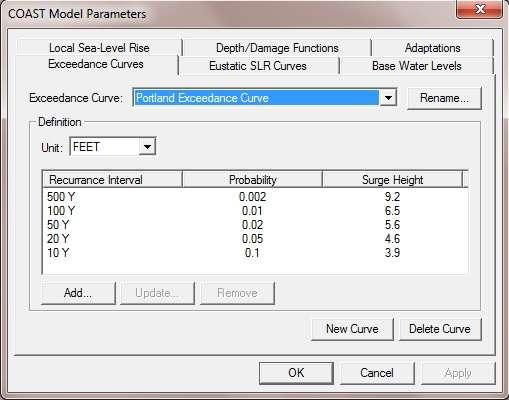
34 Year Sea Level Rise Scenario Storm Intensity (return period in years) COAST Model for City of Kingston Modeled Water Levels and Vulnerability Assessment Results Predicted Elevation of Flood Height from FEMA Flood Insurance Study, 2007 NAVD88 (ft.) 1 COAST Model of Sea Level Rise Above MHHW in 2013 Selected by Kingston (in./ft) 2 COAST Model Total Flood Elevation for Each Scenario NAVD 88 (ft.) COAST Model Expected Damage to the Value of All Buildings & Improvements From This Single Storm Incident in the Scenario Year ($ Million) COAST Model Cumulative Expected Value of All Buildings and Improvements Located on Properties Permanently Inundated by Sea Level Rise if No Action is Taken, by this Year ($ Million) 4 COAST Model Cumulative Expected Damage to the Value of All Buildings & Improvements From Sea Level Rise and All Storms, 2013 to Scenario Year ($ Million) COAST Model Cumulative Expected Damage to the Value of All Buildings & Improvements From Sea Level Rise and All Storms, 2013 to Scenario Year ($ Million, with Discounting) No SLR 10 yr n/a n/a n/a No SLR 100 yr n/a n/a n/a Lo SLR 10 yr Lo SLR 100 yr Hi SLR 10 yr Hi SLR 100 yr Lo SLR 10 yr Lo SLR 100 yr Hi SLR 10 yr Hi SLR 100 yr Tidal state is included in FEMA FIS predicted flood elevations for the 10-yr and 100-yr storms. 2 Elevation of Mean Higher High Water (MHHW) in year 2013 is 3.0 feet (NAVD 88). 3 Discount Rate of 3.3 percent applied. 4 See spreadsheet for complete list of properties. Dates Run: 06/25-30/2013 This project is funded by NYS DEC's Hudson River Estuary Program, with support from the NYS Environmental Protection Fund, in cooperation with
35 Year Sea Level Rise Scenario Storm Intensity (return period in years) COAST Model for City of Kingston Modeled Water Levels and Vulnerability Assessment Results Predicted Elevation of Flood Height from FEMA Flood Insurance Study, 2007 NAVD88 (ft.) 1 COAST Model of Sea Level Rise Above MHHW in 2013 Selected by Kingston (in./ft) 2 COAST Model Total Flood Elevation for Each Scenario NAVD 88 (ft.) COAST Model Expected Damage to the Value of All Buildings & Improvements From This Single Storm Incident in the Scenario Year ($ Million) COAST Model Cumulative Expected Value of All Buildings and Improvements Located on Properties Permanently Inundated by Sea Level Rise if No Action is Taken, by this Year ($ Million) 4 COAST Model Cumulative Expected Damage to the Value of All Buildings & Improvements From Sea Level Rise and All Storms, 2013 to Scenario Year ($ Million) COAST Model Cumulative Expected Damage to the Value of All Buildings & Improvements From Sea Level Rise and All Storms, 2013 to Scenario Year ($ Million, with Discounting) No SLR 10 yr n/a n/a n/a No SLR 100 yr n/a n/a n/a Lo SLR 10 yr Lo SLR 100 yr Hi SLR 10 yr Hi SLR 100 yr Lo SLR 10 yr Lo SLR 100 yr Hi SLR 10 yr Hi SLR 100 yr Tidal state is included in FEMA FIS predicted flood elevations for the 10-yr and 100-yr storms. 2 Elevation of Mean Higher High Water (MHHW) in year 2013 is 3.0 feet (NAVD 88). 3 Discount Rate of 3.3 percent applied. 4 See spreadsheet for complete list of properties. Dates Run: 06/25-30/2013 This project is funded by NYS DEC's Hudson River Estuary Program, with support from the NYS Environmental Protection Fund, in cooperation with
36 Year Sea Level Rise Scenario Storm Intensity (return period in years) COAST Model for City of Kingston Modeled Water Levels and Vulnerability Assessment Results Predicted Elevation of Flood Height from FEMA Flood Insurance Study, 2007 NAVD88 (ft.) 1 COAST Model of Sea Level Rise Above MHHW in 2013 Selected by Kingston (in./ft) 2 COAST Model Total Flood Elevation for Each Scenario NAVD 88 (ft.) COAST Model Expected Damage to the Value of All Buildings & Improvements From This Single Storm Incident in the Scenario Year ($ Million) COAST Model Cumulative Expected Value of All Buildings and Improvements Located on Properties Permanently Inundated by Sea Level Rise if No Action is Taken, by this Year ($ Million) 4 COAST Model Cumulative Expected Damage to the Value of All Buildings & Improvements From Sea Level Rise and All Storms, 2013 to Scenario Year ($ Million) COAST Model Cumulative Expected Damage to the Value of All Buildings & Improvements From Sea Level Rise and All Storms, 2013 to Scenario Year ($ Million, with Discounting) No SLR 10 yr n/a n/a n/a No SLR 100 yr n/a n/a n/a Lo SLR 10 yr Lo SLR 100 yr Hi SLR 10 yr Hi SLR 100 yr Lo SLR 10 yr Lo SLR 100 yr Hi SLR 10 yr Hi SLR 100 yr Tidal state is included in FEMA FIS predicted flood elevations for the 10-yr and 100-yr storms. 2 Elevation of Mean Higher High Water (MHHW) in year 2013 is 3.0 feet (NAVD 88). 3 Discount Rate of 3.3 percent applied. 4 See spreadsheet for complete list of properties. Dates Run: 06/25-30/2013 This project is funded by NYS DEC's Hudson River Estuary Program, with support from the NYS Environmental Protection Fund, in cooperation with
37 Year Sea Level Rise Scenario Storm Intensity (return period in years) COAST Model for City of Kingston Modeled Water Levels and Vulnerability Assessment Results Predicted Elevation of Flood Height from FEMA Flood Insurance Study, 2007 NAVD88 (ft.) 1 COAST Model of Sea Level Rise Above MHHW in 2013 Selected by Kingston (in./ft) 2 COAST Model Total Flood Elevation for Each Scenario NAVD 88 (ft.) COAST Model Expected Damage to the Value of All Buildings & Improvements From This Single Storm Incident in the Scenario Year ($ Million) COAST Model Cumulative Expected Value of All Buildings and Improvements Located on Properties Permanently Inundated by Sea Level Rise if No Action is Taken, by this Year ($ Million) 4 COAST Model Cumulative Expected Damage to the Value of All Buildings & Improvements From Sea Level Rise and All Storms, 2013 to Scenario Year ($ Million) COAST Model Cumulative Expected Damage to the Value of All Buildings & Improvements From Sea Level Rise and All Storms, 2013 to Scenario Year ($ Million, with Discounting) No SLR 10 yr n/a n/a n/a No SLR 100 yr n/a n/a n/a Lo SLR 10 yr Lo SLR 100 yr Hi SLR 10 yr Hi SLR 100 yr Lo SLR 10 yr Lo SLR 100 yr Hi SLR 10 yr Hi SLR 100 yr Tidal state is included in FEMA FIS predicted flood elevations for the 10-yr and 100-yr storms. 2 Elevation of Mean Higher High Water (MHHW) in year 2013 is 3.0 feet (NAVD 88). 3 Discount Rate of 3.3 percent applied. 4 See spreadsheet for complete list of properties. Dates Run: 06/25-30/2013 This project is funded by NYS DEC's Hudson River Estuary Program, with support from the NYS Environmental Protection Fund, in cooperation with
38 Next Steps in the COAST Process Select candidate adaptation actions to respond to sea level rise and storm surge, staged over time, and estimate costs of each action.
39 Possible Adaptation Actions: Hard or Soft Revetments Sea walls Jetties Levees Subway tunnel plugs Automatic floodgates Geotextile tubes Beach nourishment Dry flood-proofing Wet flood-proofing Increasing freeboard (now or later) Zoning changes Rolling easements Buyouts

40
41 Next Steps in the COAST Process For each action, modify the DDF or the spatial distribution of the vulnerable asset to represent the effect of the action.
42 Next Steps in the COAST Process Re-run the same scenarios to show benefits (avoided costs) of having taken action.
43
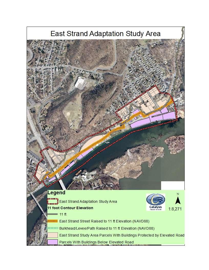
44 BENEFIT COST ANALYSIS OF ADAPTATION STRATEGIES KINGSTON Scenario B: WITH ELEVATION OF EAST STRAND STREET TO 11 FEET (NAVD 88) Scenario C: WITH ELEVATION OF BULKHEAD/WITH PATH TO 11 FEET (NAVD 88) Scenario D: PURCHASES OF ROLLING EASEMENTS, WITH TRANSFER OF TITLE TO CITY AT 2060 OR WHEN MHHW REACHES 6.0 FEET (NAVD 88) Low SLR High SLR Low SLR High SLR Low SLR High SLR Cumulative Damage to East Strand Study Area With No Action 1 Cumulative Damage with Adaptation Strategy in Place 1 Avoided Damage (Row 1 Row 2) or BENEFIT Estimated COST of Adaptation Strategy BENEFIT/COST Ratio (The higher the number above 1, the more favorable the ratio.) 46,400,000 44,100,000 46,400,000 44,100,000 46,400,000 44,100,000 4,900,000 4,700, , ,900 36,900,000 39,576,000 41,500,000 39,400,000 46,159,000 43,633,100 9,500,000 4,524,000 9,800,000 6,200, ,540, Discount Rate of 3.3% applied. 2 Does not include purchase of easements at five city-owned properties, and sewage treatment plant remains unprotected.
45 Scenario D: PURCHASES OF ROLLING EASEMENTS, WITH TRANSFER OF TITLE TO CITY AT 2060 OR WHEN MHHW REACHES 6.0 FEET (NAVD 88) Purchase Easements from all property owners whose land is at less than 11 feet elevation. City does not elevate road or bulkhead or make any capital expenditures to mitigate damages over time. Owners receive a cash payment now, and can stay on their property until 2060 or when MHHW reaches 6 feet (3 feet higher than today). Title transfers to easement holder at that time. Cash payment can be used for flood mitigation for buildings or for any purpose, such as relocation, but owner can not armor the shoreline. Sewage Treatment Plant remains unprotected. Total Estimate: $2.54 million B/C Ratio = 3.7 or 1.8 (Hi vs. Low SLR)

46 Finally: Use maps and tables in public process, modify and implement strategies.
47 Convene Stakeholders Choose Parameters Run the Model Make Decisions

48
49 Some Social Lessons Learned through The COAST Approach : Citizens want cities, towns and states to get beyond vulnerability studies and to start putting adaptation strategies in place! Appropriations for expensive strategies (e.g., elevating waterfronts or relocating WWTPs) will not occur until there is enough social, political, and economic consensus on a direction. The COAST Approach helps create this consensus.

50 Thank You! Sam Merrill:

51 Joint Proposal: Catalysis Adaptation Partners with Parsons Brinkerhoff Establishing the Proper Design Height of Protection Measures For the NYCT 207 th Street Yard 207 th Street Yard

52
 Probabilities of Surge Levels ( How many feet should be added to the normal tide height?) Predictions of Sea Level Rise into the Future (2042, 2062 or 2100?")
53 Setting of Design Height must take into account: Probabilities of Tidal Stage when Surge Occurs during the Tidal Cycle (At high or low tide?) Probabilities of Surge Levels ( How many feet should be added to the normal tide height?) Predictions of Sea Level Rise into the Future (2042, 2062 or 2100?) Design Life of the Protection Measure (30, 50 or 100 years?) Value of Protected Assets and Avoided Cumulative Expected Damages over Design Life The COAST tool applied by Catalysis Adaptation Partners will insure that costs for various protection heights are weighed against probabilities of flood heights and costs of predicted damages, including each of these factors.

54
Adapting Maine s coastal communities to sea level rise and storm surge (2015 State of the Bay Presentation)
") University of Southern Maine USM Digital Commons Presentations Casco Bay Estuary Partnership (CBEP) 2015 Adapting Maine s coastal communities to sea level rise and storm surge (2015 State of the Bay Presentation)
University of Southern Maine USM Digital Commons Presentations Casco Bay Estuary Partnership (CBEP) 2015 Adapting Maine s coastal communities to sea level rise and storm surge (2015 State of the Bay Presentation)
Managing the Risk of Catastrophes: Protecting Critical Infrastructure in Urban Areas
 Federal Reserve Bank of New York 33 Liberty Street, 10 th Floor, Benjamin Strong Room Friday November 1, 2013 Managing the Risk of Catastrophes: Protecting Critical Infrastructure in Urban Areas Session
ADVISORY BASE FLOOD ELEVATIONS (ABFEs)
") The Department of Homeland Security s Federal Emergency Management Agency is committed to helping communities that were impacted by Hurricanes Katrina and Rita rebuild safer and stronger. Following catastrophic
The Department of Homeland Security s Federal Emergency Management Agency is committed to helping communities that were impacted by Hurricanes Katrina and Rita rebuild safer and stronger. Following catastrophic
Adaptation Practices and Lessons Learned
 Adaptation Practices and Lessons Learned Increased Flooding Risk Due To Sea Level Rise in Hampton Roads: A Forum to Address Concerns, Best Practices and Plans for Adaptation Nov. 16, 2012 Virginia Modeling,
Crediting Adaptation Strategies through the National Flood Insurance Program s Community Rating System Coordinator s Manual
 Crediting Adaptation Strategies through the National Flood Insurance Program s Community Rating System Coordinator s Manual W. Thomas Hawkins, Adjunct Faculty, University of Florida, Levin College of Law
Aquidneck Island Resilience Strategy Issue Paper 4. Issue: RESIDENTIAL FLOODING
 Aquidneck Island Resilience Strategy Issue Paper 4 Issue: RESIDENTIAL FLOODING Description of Concern: While much of Aquidneck Island s geography lies outside the reach of coastal flooding, some of the
Huntington Beach LCPA 1-16 (Sunset Beach Specific Plan) DRAFT Hazard Analysis Sug Mod Working Document/Not for general circulation.
 DRAFT Hazard Analysis Sug Mod Working Document/Not for general circulation.") LCPA 1-16 (Sunset Beach Specific Plan) DRAFT Hazard Analysis Sug Mod Working Document/Not for general circulation. 3.3 Regulations (page 34) 3.3.9 (page 60) Add new Section 3.3.9 below after Flood Plain
LCPA 1-16 (Sunset Beach Specific Plan) DRAFT Hazard Analysis Sug Mod Working Document/Not for general circulation. 3.3 Regulations (page 34) 3.3.9 (page 60) Add new Section 3.3.9 below after Flood Plain
Planning for SLR Resiliency in Virginia Beach
 Old Dominion University ODU Digital Commons May 18, 2016: The Economic Impacts of Sea-Level Rise in Hampton Roads Hampton Roads Intergovernmental Pilot Project: Meetings 5-18-2016 Planning for SLR Resiliency
Coastal Vulnerability Assessment and Adaptation Plan CITY OF CLEARWATER
 Coastal Vulnerability Assessment and Adaptation Plan 1 Background Vulnerability Assessment Adaptation Plan Peril of Flood Grant 2 Background SEA LEVEL RISE ADAPTATION PROJECT This publication was funded
TREASURE COAST REGIONAL PLANNING COUNCIL M E M O R A N D U M. To: Council Members AGENDA ITEM 7C4
 TREASURE COAST REGIONAL PLANNING COUNCIL M E M O R A N D U M To: Council Members AGENDA ITEM 7C4 From: Date: Subject: Staff September 16, 2016 Council Meeting Local Government Comprehensive Plan Review
Climate Change: An Alternative View of Risk Assessment
 Policy Innovations: Effective Strategies for Adoption and Implementation Climate Change: An Alternative View of Risk Assessment Produced for Sustain Southern Maine December 11, 2012 Prepared by C.M. Bard
Adapting to. and Flooding. Report on a 2014 Survey of Waterford Residents. George Perkins Marsh Institute/Clark University and The Nature Conservancy
 Adapting to Coastal Storms and Flooding Report on a 2014 Survey of Waterford Residents George Perkins Marsh Institute/Clark University and The Nature Conservancy Town of Waterford Adapting to Coastal Storms
September 8, RE: Application for Planned Unit Development and Special Exemption Permit by Bluff Point Holdings LLC
 September 8, 2011 Northumberland County Board of Supervisors P.O. Box 129 Heathsville, VA 22473 RE: Application for Planned Unit Development and Special Exemption Permit by Bluff Point Holdings LLC Dear
Recovery Efforts and Legal Issues. Caroline Karp. Senior Lecturer Brown University
 Recovery Efforts and Legal Issues Caroline Karp Senior Lecturer Brown University When retreat is the better part of valor: Analysis of (Some) Strategies to Incentivize Retreat from the Shore EBC/RISEP
Sea Level Rise and the NFIP
 Cheryl A Johnson, PE, CFM, PMP March 26, 2014 http://www.globalchange.gov/ Sea-level rise and the likely increase in hurricane intensity and associated storm surge will be among the most serious consequences
Primer on Sea Level Rise and Future Flooding. Doug Marcy / Russell Jackson Coastal Hazards Specialists NOAA Office for Coastal Management
 Primer on Sea Level Rise and Future Flooding Doug Marcy / Russell Jackson Coastal Hazards Specialists NOAA Office for Coastal Management Sea Level has Changed Throughout Geologic History 1.7mm/year 2.9mm/year
Modernization, FEMA is Recognizing the connection between damage reduction and
 EXECUTIVE SUMMARY Every year, devastating floods impact the Nation by taking lives and damaging homes, businesses, public infrastructure, and other property. This damage could be reduced significantly
The Costs of Doing Nothing: A Sea Level Rise Synopsis for the Hampton Roads Region
 The Costs of Doing Nothing: A Sea Level Rise Synopsis for the Hampton Roads Region October of 2016 brought Hurricane Matthew to coastal Virginia, providing once again an illustration of the vulnerability
Moving Policy and Practice from Flood and Coastal Storm Damage Reduction to Risk Management
 Moving Policy and Practice from Flood and Coastal Storm Damage Reduction to Risk Management and other words of encouragement for my friends in the Planning CoP Eric Halpin, PE Special Assistant for Dam
Reviving the Culture of Preparedness
 Reviving the Culture of Preparedness May 11, 2018 Dr. Maria Ilcheva HOW CAN SOUTH FLORIDA DEVELOP AND SUSTAIN A CULTURE OF PREPAREDNESS AND RESILIENCE? Preparedness - actions and planning taken before
Hazard Mitigation Grants. Technical Assistance Session Middlesex County, NJ December 7, 2011
 Hazard Mitigation Grants Technical Assistance Session Middlesex County, NJ December 7, 2011 Outline Purpose of Hazard Mitigation Hazard Mitigation Projects Hazard Mitigation Assistance Grant Programs Using
Accounting for Long-Term Erosion and Sea Level Rise in New England: A TMAC Recommendation
 Accounting for Long-Term Erosion and Sea Level Rise in New England: A TMAC Recommendation Elena Drei-Horgan, PhD, CFM Jeremy Mull, PE Brian Caufield, PE May 2017 Establishment of TMAC, Definition, Members
Coastal Flood Insurance Studies in Virginia and Climate Change
 Coastal Flood Insurance Studies in Virginia and Climate Change VFMA Floodplain Management Workshop October 22, 2015 Jeff Gangai Why is a Coastal Restudy Needed? New Guidelines need to be implemented Atlantic
University Drive Flood Risk Management Project Phase I 58 th Ave S to 500 S of 64 th Ave S City of Fargo Project FM-15-C1
 University Drive Flood Risk Management Project Phase I 58 th Ave S to 500 S of 64 th Ave S City of Fargo Project FM-15-C1 Public Informational Meeting October 15, 2015 6:00 P.M. Overview Flood Risk FEMA
10526 Bermuda Isle Dr. Tampa, FL 33647
 Flood Analysis Memo Property Address 10526 Bermuda Isle Dr. In Partnership with: ** This property is NOT within a high-risk flood zone ** 10526 Bermuda Isle Dr. BFE = 35 ft This property is located in
Climate Change Adaptation Plan for Choiseul Bay Township, Solomon Islands
 Climate Change Adaptation Plan for Choiseul Bay Township, Solomon Islands Dr Philip Haines and Ms Shannon McGuire Sustainable Engineering Society - Technical Session 17 March 2015 1 Presentation outline
National Flood Insurance Program (NFIP) and Flood Insurance Rate Map (FIRM) San Francisco Port Commission. October 23, 2007
 and Flood Insurance Rate Map (FIRM) San Francisco Port Commission. October 23, 2007") National Flood Insurance Program (NFIP) and Flood Insurance Rate Map (FIRM) San Francisco Port Commission October 23, 2007 Flood Insurance Rate Map (FIRM) FEMA manages the NFIP using a nationwide system
National Flood Insurance Program (NFIP) and Flood Insurance Rate Map (FIRM) San Francisco Port Commission October 23, 2007 Flood Insurance Rate Map (FIRM) FEMA manages the NFIP using a nationwide system
2015 AWRA Summer Specialty Conference: Climate Change Adaptation (New Orleans, LA) June 15, 2015 Presenter: John Squerciati, P.E.
 June 15, 2015 Presenter: John Squerciati, P.E.") Economic Assessment Tools for Infrastructure Resilience Projects - FTA - Hazard Mitigation Cost Effectiveness (HMCE) Tool and Recurrence Interval Calculator for Benefit-Cost Analysis 2015 AWRA Summer Specialty
Economic Assessment Tools for Infrastructure Resilience Projects - FTA - Hazard Mitigation Cost Effectiveness (HMCE) Tool and Recurrence Interval Calculator for Benefit-Cost Analysis 2015 AWRA Summer Specialty
Skagit County Flood Insurance Study Update. Ryan Ike, CFM FEMA Region 10
 Skagit County Flood Insurance Study Update Ryan Ike, CFM FEMA Region 10 Skagit County Flood Insurance Study Process Overview Process, Schedule, & Deliverables Base Flood Elevations, Modeling, & Levees
Ocean City Office of Emergency Management. Environmental Commission Lecture Series October 24, 2017
 Ocean City Office of Emergency Management Environmental Commission Lecture Series October 24, 2017 FEMA Region II Flood Insurance Rate Maps (FIRM s) Adopted as of 10/5/2017 All of Cape May County adopted
Reducing Coastal Risk
 Reducing Coastal Risk Committee on U.S. Army Corps of Engineers Water Resources Science, Engineering, and Planning: Coastal Risk Reduction National Research Council Rick Luettich, Committee Chair Committee
Results from ECA study: Florida
 Results from ECA study: Florida Lauren Toretta McKinsey Mark Way Swiss Re Mitigation is important, but it will take decades to achieve success Global greenhouse gas emissions: Gt COe per year Slide 75
The Community Rating System in Coastal New England: Regional Approaches and Lessons Learned
 Session 4: Flood Insurance and the Community Rating System The Community Rating System in Coastal New England: Regional Approaches and Lessons Learned Abbie Sherwin - Maine Coastal Program Julie LaBranche
Location: Tampa, Florida March 6, 2013
 Discovery Meeting: West Florida Coastal Study Location: Tampa, Florida March 6, 2013 Agenda Introductions Why we are here Outline Risk MAP products and datasets Discovery Overview: Project scoping and
Sea-Level Rise: Science, Legal Issues, and Adaptation for. Florida Local Governments. Click to edit Master title style
 Sea-Level Rise: Science, Legal Issues, and Adaptation for Click to edit Master title style Florida Local Governments Click to edit Master subtitle style Daytona Beach May 22, 2015 Thomas Ruppert Coastal
Flood Analysis Memo. 629 Orangewood Dr. Dunedin, FL BFE = 21 ft
 Flood Analysis Memo Property Address 629 Orangewood Dr. In Partnership with: ** This property is NOT within a high-risk flood zone ** 629 Orangewood Dr. BFE = 21 ft This property is located in the FEMA
Agenda Item B.8 CONSENT CALENDAR Meeting Date: May 19, 2015
 Agenda Item B.8 CONSENT CALENDAR Meeting Date: May 19, 2015 TO: FROM: CONTACT: SUBJECT: Mayor and Councilmembers Jennifer Carman, Planning and Environmental Review Director Anne Wells, Advance Planning
Flood Insurance and Levees
 Flood Insurance and Levees NFIP Requirements are found in 44 (CFR) Section 65.10 General Requirements 65.10(a) Design Criteria 65.10(b) Operation Plans and Criteria 65.10(c) Maintenance Plans and Criteria
Flood Risk Management and Nonstructural Flood Risk Adaptive Measures
 Flood Risk Management and Nonstructural Flood Risk Adaptive Measures Randall Behm, P.E., CFM USACE-Omaha District Chair, National Nonstructural Flood Proofing Committee US Army Corps of Engineers BUILDING
210 W Canal Dr Palm Harbor, FL 34684
 Flood Analysis Memo Property Address In Partnership with: ** This property is within a high risk flood zone ** BFE = 6 ft This property is located in the FEMA designated high-risk zone, Zone AE - an area
Coastal Flood Hazard and Risk Maps in Denmark. Thorsten Piontkowitz & Laura Storm Henriksen, Danish Coastal Authority
 Coastal Flood Hazard and Risk Maps in Denmark Thorsten Piontkowitz & Laura Storm Henriksen, Danish Coastal Authority Contents Introduction Denmark and the coastal zone Identified flood prone areas Flood
10526 Bermuda Isle Dr. Tampa, FL 33647
 Flood Analysis Memo Property Address In Partnership with: ** This property is NOT within a high-risk flood zone ** This property is located in a FEMA low-risk zone designated as Zone X - an area of minimal
CHAPTER 4. REGULATIONS AND DEVELOPMENT STANDARDS
 CHAPTER 4. REGULATIONS AND DEVELOPMENT STANDARDS Regulations and development standards, which can be used by communities to reduce damage from natural hazards, work best when using an effective planning
More Legal Quick Takes: SLR, Law & Flooding
 More Legal Quick Takes: SLR, Law & Flooding Click to edit Master title style Click to edit Master subtitle style Erin Deady, President, Erin L. Deady, PA & Thomas Ruppert Coastal Planning Specialist, Florida
COASTALRISK. FLOODANDNATURALHAZARDRISKASSESSMENT Commercial Mayport Naval Station, Jacksonville, FL September 7, 2018
 COASTALRISK FLOODANDNATURALHAZARDRISKASSESSMENT Commercial September 7, 2018 THISREPORTISPROVIDEDSUBJECTTOTHECOASTALRISKCONSULTING,LLC.TERMSANDCONDITIONSOFUSE,WHICHIS AVAILABLEATWWW.COASTALRISKCONSULTING.COM.THISANALYSISISFURNISHED
The Citadel. Multi-Hazard Mitigation Disaster Resistant University Plan
 The Citadel Multi-Hazard Mitigation Disaster Resistant University Plan Project Objective To Develop a Disaster Resistant University Hazard Mitigation Plan Identify Hazards Profile Hazards Inventory Assets
Townsville Coastal Hazard Adaptation Pilot Project
 Townsville Coastal Hazard Adaptation Pilot Project Dorean Erhart Principal Advisor Natural Assets, NRM & Climate Change Local Government Association of Queensland Background - Partnership between the LGAQ,
August 2014 APTA Sustainability Workshop Boston, MA. Climate Change & Public Transit The New Normal
 August 2014 APTA Sustainability Workshop Boston, MA Climate Change & Public Transit The New Normal This is what Sandy looked like on October 29, 2012 2 And this is what the MTA looked like to Sandy 3 UNPRECENDENTED
National Institute of Building Sciences
 National Institute of Building Sciences Provider Number: G168 Improving the Flood Resistance of Buildings and Mitigation Techniques WE3B Peter Spanos, P.E., CFM, LEED AP (Gale Associates, Inc.) Stuart
Frequently Asked Questions Oxbow / Hickson / Bakke Ring Levee Option
 Frequently Asked Questions Oxbow / Hickson / Bakke Ring Levee Option October 16, 2012 Q1. Why has the position on a ring-levee changed? The feasibility study recommended buy-outs for areas with staging
COASTAL HAZARD MITIGATION TOOLS AND TECHNIQUES
 COASTAL HAZARD MITIGATION TOOLS AND TECHNIQUES Beach Nourishment Responsible Agency/Party: Mitigation for: Management Effort: Federal and/or State sponsored projects Long- and short-term erosion Flood
ECONOMIC EVALUATION OF FLOODPLAIN MANAGEMENT AND FLOOD MITIGATION
 ECONOMIC EVALUATION OF FLOODPLAIN MANAGEMENT AND FLOOD MITIGATION CITY OF BIRMINGHAM, ALABAMA EDWIN REVELL, CFM FLOOD PLAIN ADMINISTRATOR DENISE PRUITT, CFM PROJECT PLANNER PRESENTATION OUTLINE 1. BACKGROUND/LOCATION
Frequently Asked Questions
 Frequently Asked Questions The West of Wales Shoreline Management Plan (SMP) provides a high level strategy for managing flood and erosion risk for the coastline and is a non statutory policy document
Introduction Preparation of a Community Reconstruction Zone Plan
 Guidance for Community Reconstruction Zone Plans A Planning Toolkit for CRZ Planning Committees Table of Contents Introduction.............................................. 1 Preparation of a Community
THE ECONOMIC ARGUMENT FOR AMPHIBIOUS RETROFIT CONSTRUCTION
 THE ECONOMIC ARGUMENT FOR AMPHIBIOUS RETROFIT CONSTRUCTION Elizabeth C. English Ph.D., A.M. ASCE Associate Professor School of Architecture University of Waterloo WHAT IS AMPHIBIOUS ARCHITECTURE? Amphibious
Flood Risk Products. New Techniques for Identifying and Communicating Flood Risk
 Flood Risk Products New Techniques for Identifying and Communicating Flood Risk Mark Zito, GISP, CFM GIS Specialist Amol Daxikar, GISP, CFM Project Manager March 28, 2012 1% Flood with 3 Feet Sea Level
Updates to Maine Coastal Flood Insurance Rate Maps (FIRM s): What a Local Official Should Know. Presented by: Steve Johnson, P.E.
: What a Local Official Should Know. Presented by: Steve Johnson, P.E.") Updates to Maine Coastal Flood Insurance Rate Maps (FIRM s): What a Local Official Should Know Presented by: Steve Johnson, P.E. Town Engineer October 4, 2018 Introduction Federal Emergency Management
Updates to Maine Coastal Flood Insurance Rate Maps (FIRM s): What a Local Official Should Know Presented by: Steve Johnson, P.E. Town Engineer October 4, 2018 Introduction Federal Emergency Management
Volusia County Floodplain Management Plan 2012
 Volusia County Floodplain Management Plan 2012 Introduction The National Flood Insurance Program (NFIP) provides federally supported flood insurance in communities that regulate development in floodplains.
Step 3: Adaptation Planning & Design. Logan Airport
 Step 3: Adaptation Planning & Design Logan Airport Terminal A Satellite Doors to Harborside Substation CAT. 3 HURRICANE (MHHW) FLOOD EL. = 20.75 CAT. 2 HURRICANE (HAT) EST. FLOOD EL. = 18.42 CAT. 2 HURRICANE
History of Floodplain Management in Ascension Parish
 History of Floodplain Management in Ascension Parish presented by: Kara Moree Floodplain Coordinator February 6, 2012 Floodplain 101 Floodplain 101 Base or 1% Flood: A flood having a 1% chance of being
Survey of Hazus-MH: FEMA s Tool for Natural Hazard Loss Estimation
 Survey of Hazus-MH: FEMA s Tool for Natural Hazard Loss Estimation What is Hazus? Software tools and support system designed by FEMA for the purpose of providing communities with the means to identify
ASFPM Update and NFIP Reform. KAMM 10 th Anniversary Conference September 9, 2014
 ASFPM Update and NFIP Reform KAMM 10 th Anniversary Conference September 9, 2014 AND HE SAID Floods are 'acts of God,' but flood losses are largely acts of man. 1945 PhD Dissertation Human Adjustments
The AIR Coastal Flood Model for Great Britain
 The AIR Coastal Flood Model for Great Britain The North Sea Flood of 1953 inundated more than 100,000 hectares in eastern England. More than 24,000 properties were damaged, and 307 people lost their lives.
Southwest Florida Discovery Kick-Off Meeting. February 4, 2014
 Southwest Florida Discovery Kick-Off Meeting February 4, 2014 Agenda Introductions Outline Risk MAP products and datasets Project scoping and schedule Data gathered Next steps Gather stakeholder input/feedback
December 2016 James DeWeese. Opportunities for Enhancing Flood Resilience Quebec Flood Forum 2017 Jessica Grannis
 December 2016 James DeWeese Opportunities for Enhancing Flood Resilience Quebec Flood Forum 2017 Jessica Grannis Convenes and serves as resource to states on climate and energy issues Brings together academics
Flood Risk Management: Modelling blockage and breach scenarios February 2015
 Flood Risk Management: Modelling blockage and breach scenarios February 2015 OGN100 Document Owner: Mark Pugh Page 1 of 6 Version History: Document Date Summary of Changes Version Published 1.0 DEC-2014
Lee County, Florida Shore Protection Project. Gasparilla Segment 934 Report
 Lee County, Florida Shore Protection Project Gasparilla Segment 934 Report Economics Appendix US Army Corps of Engineers October 2016 Jacksonville District Table of Contents Executive Summary... 3 1 Introduction...
Executive Summary Introduction and Study Context Cecil County s Floodplain Flood Measurement Flood Levels...
 Executive Summary... 2 Introduction and Study Context... 4 Cecil y s Floodplain... 4 Flood Measurement... 6 Flood Levels... 6 Hazards from Floods... 7 Flood Vulnerability Assessment... 9 Study Method...
Real Options as a Tool for Valuing Investments in Adaptation to Climate Change
 Real Options as a Tool for Valuing Investments in Adaptation to Climate Change Conference on Economics of Adaptation to Climate Change in Low-Income Countries 18 May 2011 Washington, DC Peter Linquiti
Workshop Summary: Adaptation to Sea Level Rise Best Practices Village of Key Biscayne. Presented by: AECOM May 26, 2017
 Workshop Summary: Adaptation to Sea Level Rise Best Practices Village of Key Biscayne Presented by: AECOM May 26, 2017 Report Prepared June 23, 2017 Chapter 1 Introduction...1 Chapter 2 Flood Hazards...2
Delaware Bay / River Coastal Flood Risk Study. FEMA REGION II and III September 19, 2012
 Delaware Bay / River Coastal Flood Risk Study FEMA REGION II and III September 19, 2012 Agenda Risk MAP Program Overview Risk MAP Non-Regulatory Products & Datasets Region II New Jersey Coastal Flood Study
The AIR Inland Flood Model for Great Britian
 The AIR Inland Flood Model for Great Britian The year 212 was the UK s second wettest since recordkeeping began only 6.6 mm shy of the record set in 2. In 27, the UK experienced its wettest summer, which
Oban (Potentially Vulnerable Area 01/31) Local authority Main catchment Argyll and Bute Council Knapdale coastal Background This Potentially Vulnerabl
 Local authority Main catchment Argyll and Bute Council Knapdale coastal Background This Potentially Vulnerabl") Oban (Potentially Vulnerable Area 01/31) Local authority Argyll and Bute Council Main catchment Knapdale coastal Summary of flooding impacts 320 residential properties 310 non-residential properties 1.8
Oban (Potentially Vulnerable Area 01/31) Local authority Argyll and Bute Council Main catchment Knapdale coastal Summary of flooding impacts 320 residential properties 310 non-residential properties 1.8
EXECUTIVE SUMMARY. Donald Leland Craig, AICP Director of Community Development Services
 EXECUTIVE SUMMARY To: Through: From: Jim Scholl, Interim City Manager Donald Leland Craig, AICP Director of Community Development Services Nicole Malo, AICP, LEED GA Planner II Meeting Date: July 1, 2014
North Atlantic Coast Comprehensive Study: Resilient Adaption to Increasing Risk
 North Atlantic Coast Comprehensive Study: Resilient Adaption to Increasing Risk U.S. Army Corps of Engineers Coastal Storm Risk Management Planning Center of Expertise Amy M. Guise, USACE 21 November 2013
7. Understand effect of multiple annual exposures e.g., 30-yr period and multiple independent locations yr event over 30 years 3%
 I. FLOOD HAZARD A. Definition 1. Hazard: probability of water height 2. At a Specific XY floodplain location; 3. Z can be expressed as elevation (NAVD88); gauge height; height above ground (depth). 4.
Flood Solutions. Summer 2018
 Flood Solutions Summer 2018 Flood Solutions g Summer 2018 Table of Contents Flood for Lending Life of Loan Flood Determination... 2 Multiple Structure Indicator... 2 Future Flood... 2 Natural Hazard Risk...
Appendix B. A Comparison of the Minimum NFIP Requirements and the CRS
 A Comparison of the Minimum s and the CRS The Community Rating System provides credits for exceeding the minimum requirements of the National Flood Insurance Program (NFIP). Many local officials are not
Making Good Decisions Under Uncertainty: A Learning By Doing Workshop
 During a 2008 panel for the IPCC s launch of a report on water and climate, a hydrologist and an engineer called for additional monitoring and research to understand the effects of climate change. The
Public Information Meeting Rahway River Basin, New Jersey Flood Risk Management Feasibility Study
 Public Information Meeting Rahway River Basin, New Jersey Flood Risk Management Feasibility Study U.S. Army Corps of Engineers, New York District New Jersey Department of Environmental Protection 11 &
Public Meeting Impact of Hurricane Irma on Central Beach
 Public Meeting Impact of Hurricane Irma on Central Beach CITY OF NEW SMYRNA BEACH October 11, 2017 at 6:00 pm Presentation Outline Hurricane Irma Impacts Flooding Caused by Hurricane Irma Original Goals
IN THE LITTLE APPLE A PRESENTATION FOR THE 2017 ASFPM ANNUAL CONFERENCE IN KANSAS CITY, MO, MANAGING FLOOD RISK IN THE HEARTLAND
 A PRESENTATION FOR THE 2017 ASFPM ANNUAL CONFERENCE IN KANSAS CITY, MO, MANAGING FLOOD RISK IN THE HEARTLAND NONSTRUCTURAL 237 217 200 ASSESSMENT 80 252 237 217 200 119 174 237 217 200 27.59 IN THE LITTLE
Local Government Guide to Understanding the 2015 Florida Peril of Flood Act. Tampa Bay Regional Planning Council. June 2017
 Local Government Guide to Understanding the 2015 Florida Peril of Flood Act Tampa Bay Regional Planning Council June 2017 This report was funded, in part, through a grant agreement from the Florida Department
Flood Hazards & Infrastructure Risk in the Lower Mainland Towards a Regional Strategy for Risk Reduction
 Flood Hazards & Infrastructure Risk in the Lower Mainland Towards a Regional Strategy for Risk Reduction Fraser Basin Council Infrastructure Sector Workshop November 5, 2018 Lower Mainland Flood Management
THAMES-COROMANDEL DISTRICT COUNCIL COASTAL HAZARDS POLICY
 THAMES-COROMANDEL DISTRICT COUNCIL COASTAL HAZARDS POLICY 1. OBJECTIVES a) To sustainably manage the effects of coastal hazards on the District s coastal foreshore land by ensuring risk to life and property
Community Incentives for Nature-Based Flood Solutions
 Community Incentives for Nature-Based Flood Solutions A GUIDE TO FEMA S COMMUNITY RATING SYSTEM FOR CONSERVATION PRACTITIONERS The Federal Emergency Management Agency (FEMA) uses a Community Rating System
Floodplain Management. City Council Work Session April 16, 2013
 Floodplain Management City Council Work Session April 16, 2013 1 Discussion Agenda Flood Insurance Rate Changes Community Rating System Recommendation Floodplain Ordinance Enhancements Modifications Public
National and regional levee systems analysis in the UK and relevance to USA
 National and regional levee systems analysis in the UK and relevance to USA Jonathan Simm Presentation for ASFPM Conference, Grand Rapids MI Overview UK background Overview of method and description of
New Tools for Mitigation & Outreach. Louie Greenwell Stantec
 New Tools for Mitigation & Outreach Louie Greenwell Stantec Our Discussion Today Background What is Risk MAP? FEMA Products Overview of RiskMAP Data Sets Changes Since Last FIRM Depth and Analysis Grids
Gallinas Watershed Program
 S A N R A F A E L C I T Y C O U N C I L May 2, 2016 Tonight s Agenda G A L L I N A S W A T E R S H E D P R O G R A M What is the Watershed Program? Gallinas Watershed Products Community Involvement More
Non Regulatory Risk MAP Products Flood Depth and Probability Grids
 Non Regulatory Risk MAP Products Flood Depth and Probability Grids Virginia Floodplain Management Association 2015 Floodplain Management Workshop October 29th, 2015 Nabil Ghalayini, P.E., PMP, D.WRE, CFM
Glasgow City centre (Potentially Vulnerable Area 11/16) Local Plan District Local authority Main catchment Clyde and Loch Lomond Glasgow City Council
 Local Plan District Local authority Main catchment Clyde and Loch Lomond Glasgow City Council") Glasgow City centre (Potentially Vulnerable Area 11/16) Local Plan District Clyde and Loch Lomond Local authority Glasgow City Council Main catchment River Clyde Summary of flooding impacts At risk of
Glasgow City centre (Potentially Vulnerable Area 11/16) Local Plan District Clyde and Loch Lomond Local authority Glasgow City Council Main catchment River Clyde Summary of flooding impacts At risk of
Pricing storm surge risks in Florida: Implications for determining flood insurance premiums and evaluating mitigation measures
 Pricing storm surge risks in Florida: Implications for determining flood insurance premiums and evaluating mitigation measures Marilyn Montgomery Postdoctoral Fellow, Wharton Risk Center, University of
Erie County Flood Risk Review Meeting. January 18, 2018
 Erie County Flood Risk Review Meeting January 18, 2018 Agenda The value of updated flood maps for your community Review updated flood-risk data and important next steps in the Risk MAP process Increasing
Sensitivity Analyses: Capturing the. Introduction. Conceptualizing Uncertainty. By Kunal Joarder, PhD, and Adam Champion
 Sensitivity Analyses: Capturing the Most Complete View of Risk 07.2010 Introduction Part and parcel of understanding catastrophe modeling results and hence a company s catastrophe risk profile is an understanding
Strategic Flood Risk Assessment: A Local Authority Perspective. Karyn Punchard, Weymouth & Portland Borough Council
 Strategic Flood Risk Assessment: A Local Authority Perspective Karyn Punchard, Weymouth & Portland Borough Council Workshop Flooding issues in Weymouth & Portland SFRA Level 1 2005/6 SFRA Level 2 2008/9
Kirkwall (Potentially Vulnerable Area 03/05) Local Plan District Local authority Main catchment Orkney Orkney Islands Council Orkney coastal Backgroun
 Local Plan District Local authority Main catchment Orkney Orkney Islands Council Orkney coastal Backgroun") Kirkwall (Potentially Vulnerable Area 03/05) Local Plan District Orkney Local authority Orkney Islands Council Main catchment Orkney coastal Summary of flooding impacts 490 residential properties 460 non-residential
Kirkwall (Potentially Vulnerable Area 03/05) Local Plan District Orkney Local authority Orkney Islands Council Main catchment Orkney coastal Summary of flooding impacts 490 residential properties 460 non-residential
Broward County, Florida 100 -Year Flood Elevation Map and Associated Modeling. Bid No. R P1 September 27, 2017
 Broward County, Florida 100 -Year Flood Elevation Map and Associated Modeling Bid No. R2114367P1 September 27, 2017 Meet the AECOM Team 2 Key Team Roles and Responsibilities Key Benefit: AECOM has assembled
TABLE OF CONTENTS ABSTRACT... 1 INTRODUCTION... 1 BACKGROUND... 2 LITERATURE REVIEW... 6 METHODOLOGY... 8 GIS ANALYSIS... 8
 Abstract Floodplain management is fundamentally linked to floodplain mapping, both of which are necessary components to building resilience to flood risk. How do changes to Flood Insurance Rate Maps (FIRMs)
Bucks County, PA Flood Risk Review Meeting. November 2014
 Bucks County, PA Flood Risk Review Meeting November 2014 Agenda for Today Risk MAP Program overview Overview of non-regulatory Flood Risk Products and datasets Discuss mitigation action Technical overview