University Drive Flood Risk Management Project Phase I 58 th Ave S to 500 S of 64 th Ave S City of Fargo Project FM-15-C1
|
|
|
- Paula Skinner
- 5 years ago
- Views:
Transcription
1 University Drive Flood Risk Management Project Phase I 58 th Ave S to 500 S of 64 th Ave S City of Fargo Project FM-15-C1 Public Informational Meeting October 15, :00 P.M.

2 Overview Flood Risk FEMA Mapping Past Floods Project Summary Phase I Phase II Path Forward/ Project Schedule Acquisition Process Overview Questions
3 70,000 Red River of the North at Fargo, North Dakota Maximum Daily Flow Rate (cubic-feet per second) 60,000 50,000 40,000 30,000 20,000 10,000 Flood flow frequency and magnitude since 1900 shows transitions from dry to wet-cycles. 16 flood have exceeded the "Major Flood Stage" since of the 16 "major" floods have occurred since 2000 through Approximate Major Flood Stage 500-Year Flood 100-Year Flood Event The 2009 flood is the largest flood on record and equates to a 50-Year Flood Event. 0 Source: USGS river flow data from USGS Station

4 Changing Flood Risk Now Effective Floodplain 39.4 Feet River Gage (29,300 cfs) Approx. 2,051 Impacted Structures Approx. 7,500 Impacted properties 27,600 Acres Impacted After Diversion This elevation will be close to 500-year flood levels Flood of Record 40.8 Feet River Gage $70M expended to flood fight Future of the Floodplain USACE 41.1 River Gage (34,700 cfs) Approx. 19,400 Impacted Structures 36,430 Acres Impacted If I am in a community that we come back five years down the road and they are still talking about a project, I am probably going to change the map then, said Federal Emergency Management Agency s (FEMA) Deputy Associate Administrator for Mitigation, Roy Wright. (April, 2015)

 2,051 Structures")
5 Effective 39.4 RG USACE 100 year no Diversion (41.1 RG) 2,051 Structures Affected 19,400 Structures Affected
6 Floodplain Impacts

7 Early Forecast 50% Chance of 38-ft 10% Chance of 40-ft Max Forecast 44-ft
 Project Location Funding limitations require prioritization Outstanding Issues With Comprehensive Plan completed would still need: 7.")
8 Comprehensive Plan Developed in Fall 2011/Winter 2012 Certifiable Protection From the Effective Floodplain (39.4 Feet) Project Location Funding limitations require prioritization Outstanding Issues With Comprehensive Plan completed would still need: 7.6 miles of emergency clay levees 3.2 miles of sandbag levees
9 So Why implement this Comprehensive Plan? Short Term: Reduce emergency measures-immediate benefit from each project Provide real protection for existing homes that were built prior to the knowledge of the increased risk Long Term: Upon completion of Certifiable reaches-keep Housing Affordable for more of our population by making flood insurance available to residents at the lowest possible rates Combined with the FM Diversion- Provide for greater than 100 year protection for the largest population center in ND

10 Property Acquisitions (Since 2009) 180 Properties Purchased Over 320 since 1990 At cost of over $58 million Cass County purchased 14 additional homes needed Diversion Authority is in process of acquiring 17 additional properties within Fargo Remaining Properties Under Comprehensive Plan 121 properties to be acquired Approximately $36 million

11 Completed Projects (Since 2009) Over 18 miles constructed *47 miles of emergency levees constructed by the City in 2009 Project Cost $120 million Reduces required sandbags by approximately 4.5 million 50% of the Comprehensive Plan Completed

12 In Progress Projects Combination of Projects under Construction or under design for 2016/2017 construction 12 City of Fargo Led 7 Diversion Authority Led Over 5 miles in progress City Project Costs $71 million Construction Cost $37 million 65% of the Comprehensive Plan completed once these projects are done

13 Remaining Projects Approx. 10 miles remaining *excludes Cass County 20 Area Project Cost $130 million # Does not include south side line of protection # Does not include 2016 planned # Does not included Diversion Authority More Flow Through Town Projects Type of Projects: Levees along River & Legal Drains Road Raises Includes Interstate 29 at Drain 27 92% of the Comprehensive Plan would be completed

14 Project Location

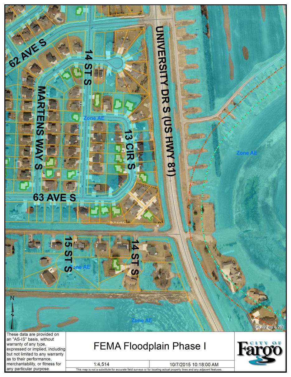
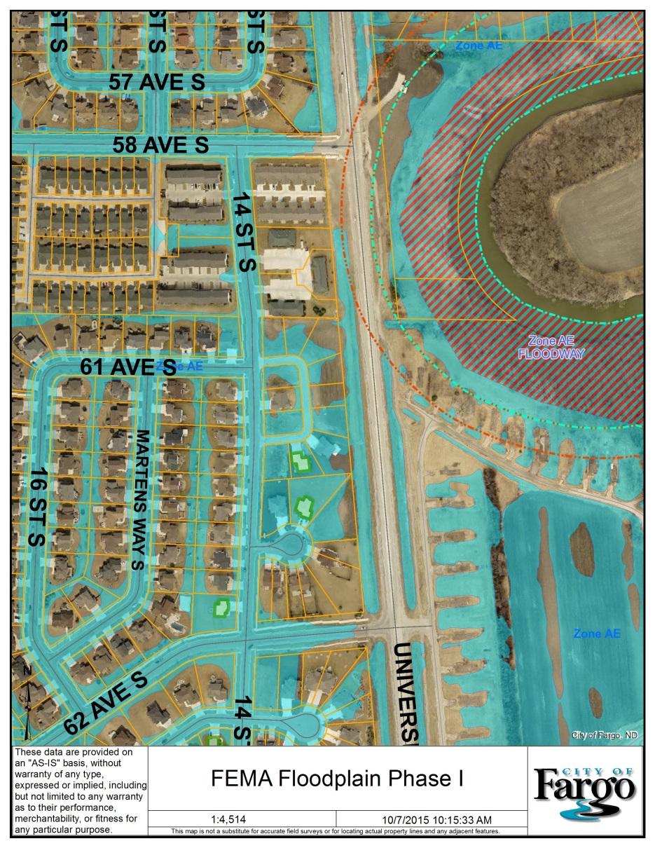
15 Project Features, Goals & Considerations: Phase I 39.5 Plus Freeboard Levee West side of University Drive Floodwall 500 feet Earthen 3,200 feet
16 Project Features, Goals & Considerations: Phase I cont. Utility Relocations Temporary closure on University Drive near 58 th Ave South during flood events Improvements to storm lift station, storm sewer and gatewell structure Road raises at 62 nd and 64 th Ave South
17 Project Features: Project Overview

18 Project Features: Phase I

19 Project Features: Phase I Cont.

20 Project Features: Phase I Cont.

21 Project Features: Phase I Cont.

22 Project Features: Phase I Cont.

23 Frequently Asked Questions Why isn t the levee on the east side of University Drive? Soil stability issues on the east side of University Drive Reduce the levee crossing back and forth across University Drive Large utility relocations
24 Frequently Asked Questions Why build levee if Diversion Project is constructed? Levee will provide real/interim flood protection Levee will be compatible with the Diversion Project by providing protection on the greater than 100 year flood events Levee + Diversion = Increased level of flood protection Will I be assessed for this levee project? No levee is being designed and constructed with Fargo Infrastructure Sales Tax Dollars, as well as dollars from the State

25 Frequently Asked Questions Where will University Drive traffic be detoured to during a flood? West to 25 th Street South


26 Estimated Project Construction Cost Phase I - $4.3 Million

27 Easement Acquisition Process Initial Contact (Easement Acquisition Form) Donate Minimum Payment Policy Mutual Agreed Amount Appraised Appraisal Review Offer with Copy of Appraisal Mailed Out Closing Set Up Recording of Documents
28 Path Forward / Schedule October 15, 2015 Public Meeting October 20, 2015 Neighborhood Walk-Thru Survey crews on site October 19 & 20 Spring 2015 Utility relocations Summer/Fall 2016 Construct Phase I Phase II Schedule not yet determined
29 Questions?
Frequently Asked Questions Oxbow / Hickson / Bakke Ring Levee Option
 Frequently Asked Questions Oxbow / Hickson / Bakke Ring Levee Option October 16, 2012 Q1. Why has the position on a ring-levee changed? The feasibility study recommended buy-outs for areas with staging
FINAL TECHNICAL MEMORANDUM AWD FLOWS THROUGH FLOOD DAMAGE REDUCTION AREA July 16, 2012
 FINAL TECHNICAL MEMORANDUM AWD-00002 FLOWS THROUGH FLOOD DAMAGE REDUCTION AREA July 16, 2012 Table of Contents TABLE OF CONTENTS Table of Contents... 1 Executive Summary... 2 1 Objective... 4 2 Study Approach...
Upper Joachim Creek Public Survey on Potential Flood Risk Reduction
 Upper Joachim Creek Public Survey on Potential Flood Risk Reduction This survey is intended to help the interagency planning committee to receive public feedback on specific flood risk reduction techniques,
DuPage County East Branch DuPage River Resiliency Project. Benefit Cost Analysis
 DuPage County East Branch DuPage River Resiliency Project Benefit Cost Analysis 1.0 Benefit Cost Analysis Preparation The BCA for this proposal was a collaborative effort between DuPage County, V3 engineering
Floodplain Management Plan
 Floodplain Management Plan CITY OF FORT WORTH TFMA 2016 Spring Conference March 10, 2016 Agenda 1. Fort Worth Higher Standards (NFIP & CRS) 2. Floodplain Management Plan Overview and Results 3. Project
Requirements for Mapping Levees Complying with Section of the NFIP Regulations
 FACT SHEET Requirements for Mapping Levees Complying with Section 65.10 of the NFIP Regulations As part of a mapping project, it is the levee owner s or community s responsibility to provide data and documentation
BUTTS COUNTY, GEORGIA AND INCORPORATED AREAS
 BUTTS COUNTY, GEORGIA AND INCORPORATED AREAS Butts County Community Name Community Number BUTTS COUNTY (UNICORPORATED AREAS) 130518 FLOVILLA, CITY OF 130283 JACKSON, CITY OF 130222 JENKINSBURG, TOWN OF
Disaster Insurance: Are States and Insurance Companies Prepared?
 Disaster Insurance: Are States and Insurance Companies Prepared? National Conference of State Legislatures 2015 Legislative Summit Roy Wright Deputy Associate Administrator for Insurance and Mitigation
Skagit County Flood Insurance Study Update. Ryan Ike, CFM FEMA Region 10
 Skagit County Flood Insurance Study Update Ryan Ike, CFM FEMA Region 10 Skagit County Flood Insurance Study Process Overview Process, Schedule, & Deliverables Base Flood Elevations, Modeling, & Levees
FREQUENTLY ASKED QUESTION ABOUT FLOODPLAINS Michigan Department of Environmental Quality
 FREQUENTLY ASKED QUESTION ABOUT FLOODPLAINS Michigan Department of Environmental Quality WHAT IS A FLOOD? The National Flood Insurance Program defines a flood as a general and temporary condition of partial
Authors: Terry Zien, Brian Rast and the Silver Jackets Co presenters: Brian Rast, Dave Lupardus and Frank Dolan
 Authors: Terry Zien, Brian Rast and the Silver Jackets Co presenters: Brian Rast, Dave Lupardus and Frank Dolan http://www.mvp.usace.army.mil/missions/civilworks/floodriskm anagement/emergencyactionplanguidebook.aspx
COMMITTEE OF THE WHOLE AGENDA August 29, :30 PM City Hall Council Chambers
 COMMITTEE OF THE WHOLE AGENDA August 29, 2011-5:30 PM City Hall Council Chambers Committee of the Whole Meeting 1. Flood Mitigation Strategy: Plan, Priority & Funding 2. Proposed 2012 Operating and Capital
Flood Insurance and Levees
 Flood Insurance and Levees NFIP Requirements are found in 44 (CFR) Section 65.10 General Requirements 65.10(a) Design Criteria 65.10(b) Operation Plans and Criteria 65.10(c) Maintenance Plans and Criteria
STATE OF MINNESOTA DEPARTMENT OF NATURAL RESOURCES DAM SAFETY AND PUBLIC WATERS WORK PERMIT APPLICATION FINDINGS OF FACT
 STATE OF MINNESOTA DEPARTMENT OF NATURAL RESOURCES DAM SAFETY AND PUBLIC WATERS WORK PERMIT APPLICATION 2016-0386 FINDINGS OF FACT In the Matter of the Dam Safety and Public Waters Work Permit Application
EMERGENCY ACTION PLAN GUIDEBOOK
 EMERGENCY ACTION PLAN GUIDEBOOK Presented by: Terry Zien and Bonnie Greenleaf US Army Corps of Engineers Background Purpose Overview of Guidebook Discussion of Key Chapters Minnesota Silver Jackets Natural
ENGINEERING REPORT FREEBOARD ANALYSIS. HOUSATONIC RIVER and NAUGATUCK RIVER FLOOD PROTECTION PROJECTS SECTION 1. ANSONIA and DERBY, CONNECTICUT
 ENGINEERING REPORT FREEBOARD ANALYSIS HOUSATONIC RIVER and NAUGATUCK RIVER FLOOD PROTECTION PROJECTS SECTION 1 ANSONIA and DERBY, CONNECTICUT December 2010 MMI #1560-119 and #3118-03 Prepared for: City
Army Corps of Engineers Indianapolis North Questions and Answers July QUESTION 1: What is the Indianapolis White River North project?
 Army Corps of Engineers Indianapolis North Questions and Answers July 2012 QUESTION 1: What is the Indianapolis White River North project? ANSWER 1: The project involves construction of floodwalls and
Minimum Standards For USACE Evaluation of Levee Systems For the National Flood Insurance Program
 Minimum Standards For USACE Evaluation of Levee Systems For the National Flood Insurance Program Christopher N. Dunn, P.E., Director Hydrologic Engineering Center ASCE Water Resource Group 20 October,
Action Items for Flood Risk Management on Wildcat Creek Interagency success with floodplain management plans and flood forecast inundation maps
 Presentation to USACE 2012 Flood Risk Management and Silver Jackets Joint Workshop, Harrisburg, Pennsylvania Action Items for Flood Risk Management on Wildcat Creek Interagency success with floodplain
Attachment B. King County Flood Control Zone District Work Program
 Attachment B King County Flood Control Zone District Work Program The King County Flood Control Zone District work program is comprised of two major categories: Programmatic Work Program o Flood Preparedness,
CRISP COUNTY, GEORGIA AND INCORPORATED AREAS
 CRISP COUNTY, GEORGIA AND INCORPORATED AREAS Community Name Community Number ARABI, CITY OF 130514 CORDELE, CITY OF 130214 CRISP COUNTY (UNINCORPORATED AREAS) 130504 Crisp County EFFECTIVE: SEPTEMBER 25,
DES MOINES CITY OF TWO RIVERS. Flooding Risk & Impact to Development
 DES MOINES CITY OF TWO RIVERS Flooding Risk & Impact to Development River System Des Moines Flood Protection Des Moines Flood Protection cont. Infrastructure Over 24 miles of levees 21stormwater pump stations
Georgia Silver Jackets Team
 Georgia Silver Jackets Team 9 th Annual GAFM Technical Conference Jeff Morris GA SJ Collaborator Savannah District, USACE US Army Corps of Engineers SMART GOVERNMENT Integrate and synchronize flood risk
Federal Emergency Management Agency
 Page 1 of 4 Date: January 27, 2015 COMMUNITY AND MAP PANEL INFORMATION COMMUNITY CITY OF FARGO, CASS COUNTY, LEGAL PROPERTY DESCRIPTION Lots 28, 32, 42 and 43, Block 2, Lot 9, Block 8, Legacy I Fourth,
Role of Disaster Insurance in Improving Resilience: An Expert Meeting The Resilient America Roundtable
 Role of Disaster Insurance in Improving Resilience: An Expert Meeting The Resilient America Roundtable National Academy of Science Washington, DC July 9, 2015 Roseville Demographics Primary population
ECONOMIC EVALUATION OF FLOODPLAIN MANAGEMENT AND FLOOD MITIGATION
 ECONOMIC EVALUATION OF FLOODPLAIN MANAGEMENT AND FLOOD MITIGATION CITY OF BIRMINGHAM, ALABAMA EDWIN REVELL, CFM FLOOD PLAIN ADMINISTRATOR DENISE PRUITT, CFM PROJECT PLANNER PRESENTATION OUTLINE 1. BACKGROUND/LOCATION
Flood Risk Management and Nonstructural Flood Risk Adaptive Measures
 Flood Risk Management and Nonstructural Flood Risk Adaptive Measures Randall Behm, P.E., CFM USACE-Omaha District Chair, National Nonstructural Flood Proofing Committee US Army Corps of Engineers BUILDING
 US Army Corps of Engineers Attn: Brett Coleman 180 5 th St. East, Suite 700 (PM-B) St. Paul, MN 55101 Mr. Coleman: The Corps has been hired by Fargo to protect Fargo, a hired gun. Get whoever you need
U.S. Army Corp of Engineers
 U.S. Army Corp of Engineers PL 84-99 Levee Inspections and Levee Certification Hank DeHaan Rock Island District March 9, 2011 US Army Corps of Engineers U.S. Army Corps of Engineers Flood Damage Reduction
Draft VALLEY CITY 100 YEAR EVENT FLOOD PROTECTION. Citywide Planning Report Valley City, ND. December 2016
 VALLEY CITY 100 YEAR EVENT FLOOD PROTECTION Citywide Planning Report Valley City, ND Prepared for: City of Valley City Valley City, ND Revised December 2016 Project #5416105 NATIONAL PERSPECTIVE REGIONAL
Public Information Meeting Rahway River Basin, New Jersey Flood Risk Management Feasibility Study
 Public Information Meeting Rahway River Basin, New Jersey Flood Risk Management Feasibility Study U.S. Army Corps of Engineers, New York District New Jersey Department of Environmental Protection 11 &
Federal Flood Risk Management Standard
 Federal Flood Risk Management Standard National Waterways Conference 2015 Annual Meeting Roy Wright Roy Deputy Wright Associate Administrator for Insurance and Mitigation Deputy September Associate 18,
City of Santa Clarita Engineering Services Division Valencia Boulevard Santa Clarita, CA (661) Levee Certification
 Levee Certification") City of Santa Clarita Engineering Services Division 23920 Valencia Boulevard Santa Clarita, CA 91355 (661) 255-4942 Levee Certification FEMA is currently updating the nation s flood hazard maps under a
City of Santa Clarita Engineering Services Division 23920 Valencia Boulevard Santa Clarita, CA 91355 (661) 255-4942 Levee Certification FEMA is currently updating the nation s flood hazard maps under a
King County Flood Control District 2015 Work Program
 Attachment A 2015 Work Plan 10-24-14 King County Flood Control District 2015 Work Program The District work program is comprised of three categories: district oversight and policy development, operations,
Delaware River Basin Commission s Role in Flood Loss Reduction Efforts
 Delaware River Basin Commission s Role in Flood Loss Reduction Efforts There is a strong need to reduce flood vulnerability and damages in the Delaware River Basin. This paper presents the ongoing role
Community Development Department
 Community Development Department Ryan DeVore, Interim Director of Community Development Scot Mende, Principal Planner Bill Busath, Interim Director of Utilities Connie Perkins, Senior Engineer, Floodplain
2011 MT Floods Damages and Recovery Options
 MONTANA 2011 MT Floods Damages and Recovery Options Damage Estimates Public Works: Between $57.5 million Individual: id Housing Assistance $4,442,194 Small Business Assistance $1,634,100 Other Needs
History of Floodplain Management in Ascension Parish
 History of Floodplain Management in Ascension Parish presented by: Kara Moree Floodplain Coordinator February 6, 2012 Floodplain 101 Floodplain 101 Base or 1% Flood: A flood having a 1% chance of being
ADVISORY BASE FLOOD ELEVATIONS (ABFEs)
") The Department of Homeland Security s Federal Emergency Management Agency is committed to helping communities that were impacted by Hurricanes Katrina and Rita rebuild safer and stronger. Following catastrophic
The Department of Homeland Security s Federal Emergency Management Agency is committed to helping communities that were impacted by Hurricanes Katrina and Rita rebuild safer and stronger. Following catastrophic
Using GISWeb to Determine Your Property s Flood Zone
 Using GISWeb to Determine Your Property s Flood Zone 1. In a new browser window, go to http://www.co.santacruz.ca.us/departments/geographicinformationsystemsgis.aspx 2. Click on GISWeb - GIS Mapping Application
Improving Coordinated Flood Preparedness and Response
 Improving Coordinated Flood Preparedness and Response Illinois Silver Jackets Hank DeHaan Rock Island and Saint Louis Districts October 2011 US Army Corps of Engineers Illinois Silver Jackets Program Illinois
Hazard Mitigation Grants. Technical Assistance Session Middlesex County, NJ December 7, 2011
 Hazard Mitigation Grants Technical Assistance Session Middlesex County, NJ December 7, 2011 Outline Purpose of Hazard Mitigation Hazard Mitigation Projects Hazard Mitigation Assistance Grant Programs Using
King County Flood Control District Flood Risk Reduction Work Program and Accomplishments
 King County Flood Control District Flood Risk Reduction Work Program and Accomplishments Brian Murray Water and Land Resources Division April 26, 2016 Department of Natural Resources and Parks Water and
Comprehensive Flood Mitigation for 12,000 Properties
 Comprehensive Flood Mitigation for 12,000 Properties Lori Rafferty, PE, CFM, Louisville MSD & Louie Greenwell, GISP, CFM, T&M Associates Association of State Floodplain Managers 2014 State Conference June
Barnes County Water Resource District
 Barnes County Water Resource District PO Box 306 Valley City, ND 58072 701-845-8508 April 14, 2014 MEETING MINUTES PRESENT MEMBERS: Chairperson Jerry Hieb; Manager Ken Evenson; Manager Bruce Anderson;
Flood Map Revisions. Town of Nags Head Public Information and Input Session. December 14, 2016, 6 pm
 Flood Map Revisions Town of Nags Head Public Information and Input Session December 14, 2016, 6 pm Flood Map Revisions New preliminary flood maps released for Dare County June 30, 2016 www.nagsheadnc.gov/floodmaps
Subject: Upper Merrimack and Pemigewasset River Study Task 9 - Water Supply Evaluation
 Memorandum To: From: Barbara Blumeris, USACE Ginger Croom and Kirk Westphal, CDM Date: April 14, 2008 Subject: Upper Merrimack and Pemigewasset River Study Task 9 - Water Supply Evaluation Executive Summary
FLOOD INSURANCE. Most mortgage lenders require flood insurance for
 FLOOD INSURANCE Anywhere it rains, it can flood. A flood is a general and temporary condition where two or more acres of normally dry land or two or more properties are inundated by water. Many conditions
FLOODPLAIN DEVELOPMENT VARIANCE APPLICATION PACKET
 FLOODPLAIN DEVELOPMENT VARIANCE APPLICATION PACKET Sutter County Water Resources Department 1130 Civic Center Boulevard Yuba City, California, 95993 (530) 822-7400 Floodplain management regulations cannot
Presentation Outline. Wimberley Witnessing the Flood. Wimberley & Home Memorial Weekend Flood. Observations/Comments
 Wimberley Witnessing the Flood Date: September 4, 2015 Presented by: John A. Espinoza, PE, CFM;MS Engineering Cindy Engelhardt, PE, CFM; lff Associates Mike Moya, PE, CFM; lff Associates Presentation Outline
Erie County Flood Risk Review Meeting. January 18, 2018
 Erie County Flood Risk Review Meeting January 18, 2018 Agenda The value of updated flood maps for your community Review updated flood-risk data and important next steps in the Risk MAP process Increasing
FEMA FLOOD MAPS Public Works Department Stormwater Management Division March 6, 2018
 FEMA FLOOD MAPS Public Works Department Stormwater Management Division March 6, 2018 Presentation Overview FEMA National Flood Insurance Program (NFIP) FEMA Community Rating System (CRS) Flood Insurance
UPDATE ON DALLAS FLOODWAY
 UPDATE ON DALLAS FLOODWAY ENVIRONMENTAL IMPACT STATEMENT [ EIS ] Transportation and Trinity River Project Committee Rob Newman Director, Trinity River Corridor Project, Fort Worth District 28 April 2014
Chapter 6 - Floodplains
 Chapter 6 - Floodplains 6.1 Overview The goal of floodplain management is to reduce the potential risks to both existing and future developments, and infrastructure, in the 100-year floodplain. Over the
Northwest Flood Fight Workshops
 Northwest Flood Fight Workshops September 24, 2014 IWR Webinar D. Leslie Miller, P.E. (Les) Flood Preparedness Program Manager US Army Corps of Engineers, Portland District US Army Corps of Engineers Welcome
Risk Based Approaches for Levees in the U.S. and Abroad: Lessons for the NFIP
 Proud Platinum Sponsor of the ASFPM 2017 Annual Conference Risk Based Approaches for Levees in the U.S. and Abroad: Lessons for the NFIP Mike Seering (AECOM) David Powers (HR Wallingford) ASFPM 2017 Annual
Flood Risk in the Schuylkill Watershed. Planning for Resilient Communities
 Flood Risk in the Schuylkill Watershed Planning for Resilient Communities Welcome to Our Poster Session! We are here to talk about: Flood Risk in the Schuylkill River Watershed Taking Action to Reduce
Memorandum. Jt~1A. Jordan, P.E. Assistant City Manager CITY OF DALLAS
 Memorandum DATE May 15, 2009 CITY OF DALLAS TO Trinity River Committee Members: David A. Neumann (Chair) Mayor Pro Tem Dr. Elba Garcia (Vice-Chair) Deputy Mayor Pro Tem Dwaine Caraway Carolyn R. Davis
Wetzel County Floodplain Ordinance
 Wetzel County Floodplain Ordinance AUTHORITY AND PURPOSE: THE PROVISIONS OF THIS ORDINANCE HAVE BEEN PREPARED WITH THE INTENTION OF MEETING THE REQUIREMENTS OF SECTION 60.3 (D) OF THE NATIONAL FLOOD INSURANCE
Lexington Green P2# Section 205 of the 1948 Flood Control Act Flood Risk Management. Federal Interest Determination
 Lexington Green P2#443918 Section 205 of the 1948 Flood Control Act Flood Risk Management Federal Interest Determination Buffalo District US Army Corps of Engineers 5/24/2016 US Army Corps of Engineers
Bucks County, PA Flood Risk Review Meeting. November 2014
 Bucks County, PA Flood Risk Review Meeting November 2014 Agenda for Today Risk MAP Program overview Overview of non-regulatory Flood Risk Products and datasets Discuss mitigation action Technical overview
Gail Moldovan-Trujillo, ACSR,CPIW Hagan Hamilton Insurance 2012 NFIP Agency of the year Flood Insurance Specialist & Consultant
 Gail Moldovan-Trujillo, ACSR,CPIW Hagan Hamilton Insurance 2012 NFIP Agency of the year Flood Insurance Specialist & Consultant Flood Insurance regulations continue to change at a very rapid pace, therefore
Passaic River Basin Flood Advisory Commission Report/Status of Recommendations. October 2014 Update
 Passaic River Basin Flood Advisory Commission Report/Status of Recommendations October 2014 Update Passaic River Basin Flood Advisory Commission April 2010: By Executive Order, Governor Christie created
Technical Memorandum 3.4 E Avenue NW Watershed Drainage Study. Appendix E Floodplain Impacts and Implications Memo
 Technical Memorandum 3.4 E Avenue NW Watershed Drainage Study Appendix E Floodplain Impacts and Implications Memo September 8, 2017 City of Cedar Rapids E Avenue Watershed Drainage Study Memo Date: Tuesday,
Flood Hazards and Flood Risk, the Impact of a Changing Climate
 Flood Hazards and Flood Risk, the Impact of a Changing Climate Sally A. McConkey, P.E. CFM, D. WRE. Illinois State Water Survey June 14, 2017 Topics ISWS Coordinated Hazard Assessment and Mapping Program
10526 Bermuda Isle Dr. Tampa, FL 33647
 Flood Analysis Memo Property Address In Partnership with: ** This property is NOT within a high-risk flood zone ** This property is located in a FEMA low-risk zone designated as Zone X - an area of minimal
NONSTRUCTURAL FLOOD RISK MANAGEMENT ECONOMIC ASSESSMENT FOR LYCOMING COUNTY LYCOMING COUNTY, PENNSYLVANIA
 NONSTRUCTURAL FLOOD RISK MANAGEMENT ECONOMIC ASSESSMENT FOR LYCOMING COUNTY LYCOMING COUNTY, PENNSYLVANIA Study requested by: Study supported by: Study led by: Lycoming County 330 Pine Street Williamsport,
Executive Summary Levee Engineering Assessments September 26, 2014
 Executive Summary s September 26, 2014 Purpose Multnomah County Drainage District (MCDD), the agency responsible for managing the Columbia Corridor levee system, received notification that in August of
Why do we care about floodplains?
 NFIP 101 Outline What is the NFIP? What are its goals? What is a flood? A floodplain? Maps, FIRMs, and FISs NFIP Requirements Local Flood Ordinances & Permitting Tips, Tricks, & Tools Mitigation & Other
Chemung HUC-8 Watershed Project. February 1, 2011
 Chemung HUC-8 Watershed Project Kickoff Bi Fl t NY Big Flats, NY February 1, 2011 Introductions FEMA Region II Alan Springett, Senior Engineer, FEMA Risk Analysis Risk Assessment Lead Robert Schaefer,
July 31, 2017 NFIP Flood Map Open House Flood Maps 101 Flood Mapping acronyms History of the NFIP Flood Mapping Updates Flood Insurance Fairhope,
 July 31, 2017 NFIP Flood Map Open House Flood Maps 101 Flood Mapping acronyms History of the NFIP Flood Mapping Updates Flood Insurance Fairhope, Alabama Flood Maps Fairhope Permitting Jurisdiction Coastal
Regional Economic Impact of Cass County, ND and Clay County, MN
 51 Broadway Suite 500 Fargo, ND 58102 701.364.1900 Fax 701.293.7819 Regional Economic Impact of Cass County, ND and Clay County, MN GFMEDC Mission The mission of the Greater Fargo Moorhead Economic Development
This survey is expected to take approximately 20 minutes and must be completed in one session.
 State Flood Assessment Survey 1 Introduction Thank you for your willingness to participate in this online survey as part of the State Flood Assessment effort. This first step toward developing comprehensive
2018 WASHOE COUNTY BALLOT QUESTION WC 1
 2018 WASHOE COUNTY BALLOT QUESTION WC 1 Shall Washoe County be authorized to levy an additional property tax rate for the purpose of paying for the cost of designing, acquiring, constructing, improving
COMMUNITY CERTIFICATIONS
 OMB No. xxxxxxxx Expires: xxxxxxxx National Flood Insurance Program Community Rating System COMMUNITY CERTIFICATIONS D R A F T CRS COMMUNITY CERTIFICATIONS The following community certifications are part
Key Fundamentals of Flood Insurance in the NFIP!
 a Welcome to Key Fundamentals of Flood Insurance in the NFIP! A Before and After approach for Housing Counselors Presented by: 1 Before the Flood Presenter Melanie Graham After the Flood Presenter Erin
This survey is expected to take approximately 20 minutes and must be completed in one session.
 Introduction Thank you for your willingness to participate in this online survey as part of the State Flood Assessment effort. This first step toward developing comprehensive flood planning for Texas does
BY BOB WOODS PLANNING TODAY FOR TOMORROW S TERRAY SYLVESTER / GETTY IMAGES
 BY BOB WOODS PLANNING TODAY FOR TOMORROW S TERRAY SYLVESTER / GETTY IMAGES As weather-related events such as hurricanes multiply and intensify, states and municipalities are recognizing the urgent need
G318 Local Mitigation Planning Workshop. Module 2: Risk Assessment. Visual 2.0
 G318 Local Mitigation Planning Workshop Module 2: Risk Assessment Visual 2.0 Unit 1 Risk Assessment Visual 2.1 Risk Assessment Process that collects information and assigns values to risks to: Identify
A Review of Our Legacy System, History of Neglect, Current Issues, and the Path Forward for Levee Safety
 4 th NACGEA GEOTECHNICAL WORKSHOP January 29, 2010 A Review of Our Legacy System, History of Neglect, Current Issues, and the Path Forward for Levee Safety Presented by: Leslie F. Harder, Jr., Phd, PE,
10526 Bermuda Isle Dr. Tampa, FL 33647
 Flood Analysis Memo Property Address 10526 Bermuda Isle Dr. In Partnership with: ** This property is NOT within a high-risk flood zone ** 10526 Bermuda Isle Dr. BFE = 35 ft This property is located in
Flood Insurance for Local Officials and Floodplain Managers. What Every Community Official Needs to Know About Flood Insurance
 Flood Insurance for Local Officials and Floodplain Managers What Every Community Official Needs to Know About Flood Insurance Illinois Association for Floodplain and Stormwater Management 2011 Annual Conference
1 Rare Hazard event is not likely to occur within 100 years. 2 Occasional Hazard event is likely to occur within 100 years
 5.3 HAZARD RANKING After the hazards of concern were identified for Onondaga County, the hazards were ranked to describe their probability of occurrence and their impact on population, property (general
Mitigation in a Changing Environment: Preserving our Heritage while Investing in Mitigation for a More Resilient Nation
 Mitigation in a Changing Environment: Preserving our Heritage while Investing in Mitigation for a More Resilient Nation Miami Design Preservation League 2nd Annual Resiliency Workshop April 7, 2018 Nick
King County, WA DFIRM Update and Seclusion Process. Webinar June 14, 2016
 King County, WA DFIRM Update and Seclusion Process Webinar June 14, 2016 Agenda King County DFIRM Study History What is/has been done Process for moving forward Seclusion Seclusion mapping process Seclusion
FARGO CITY COMMISSION AGENDA Monday, May 23, :15 p.m. Executive Session at 4:15 p.m.
 FARGO CITY COMMISSION AGENDA Monday, May 23, 2016 4:15 p.m. Executive Session at 4:15 p.m. Roll Call. PLEASE NOTE: The City Commission will convene on Monday, May 23, 2016 at 4:15 p.m. and retire into
Sources of FEMA Funding
 ASFPM Nonstructural/Floodproofing Workshops Sources of FEMA Funding ASFPM Nonstructural/Floodproofing Committee Gene Barr, CFM Principal Project Manager Nonstructural Specialist Sources of FEMA Funding
Adaptation Practices and Lessons Learned
 Adaptation Practices and Lessons Learned Increased Flooding Risk Due To Sea Level Rise in Hampton Roads: A Forum to Address Concerns, Best Practices and Plans for Adaptation Nov. 16, 2012 Virginia Modeling,
Floodplain Management 101. Mississippi Emergency Management Agency Floodplain Management Bureau
 Floodplain Management 101 Mississippi Emergency Management Agency Floodplain Management Bureau Stafford Act The Stafford Disaster Relief and Emergency Assistance Act (Stafford Act) (Public Law 100-707)
Walter Road Jefferson Parish Repetitive Loss Area Analysis
 Walter Road Jefferson Parish Repetitive Loss Area Analysis www.floodhelp.uno.edu Supported by FEM A Repetitive Loss Area Analysis Background Jefferson Parish Walter Road Area The National Flood Insurance
CDBG-DR, BW-12, CRS and Dauphin County, PA: What do they have in common? 2015 ASFPM Annual Conference
 CDBG-DR, BW-12, CRS and Dauphin County, PA: What do they have in common? 2015 ASFPM Annual Conference June 3, 2015 Today's Speaker Rob Flaner Hazard Mitigation Program Manager, Tetra Tech, Inc. Over 25
TOWN OF KENT, CT PLANNING AND ZONING COMMISSION
 TOWN OF KENT, CT PLANNING AND ZONING COMMISSION FLOOD PLAIN MANAGEMENT REGULATIONS Whereas, Congress has determined that a National Flood Insurance Program would alleviate personal hardships and economic
Flood Plain Management Annual Progress Report September 2014
 Flood Plain Management Annual Progress Report September 2014 Flood Plains in the City of Santa Cruz The City of Santa Cruz flood plains encompass the low-lying areas along the San Lorenzo River through
A Flood Mitigation Plan for the Non-Tidal N.J. Section of the Delaware River Basin. Sussex County Kick-off Meeting November 28, 2006
 A Flood Mitigation Plan for the Non-Tidal N.J. Section of the Delaware River Basin Sussex County Kick-off Meeting November 28, 2006 The Delaware River. crosses many boundaries Four states: DE, PA, NJ,
Cedric Grant, CAO Gwen LeBlanc, CFO Bill Roux, Director, Drainage
 Tommy Martinez, Parish President Cedric Grant, CAO Gwen LeBlanc, CFO Bill Roux, Director, Drainage Presented and Approved May 4, 2009 East Ascension Consolidated Gravity Drainage District No. 1 Commission
APPENDIX K Drainage Study
 APPENDIX K Drainage Study Storm Drainage Study For Project 65 Sacramento, California Prepared for: Capital Station 65, LLC Prepared by: Nolte Associates, Inc. 2495 Natomas Park Drive, Fourth Floor Sacramento,
SUBJECT: EXECUTIVE DIRECTOR'S REPORT FOR JANUARY 19, 2017 WATER INFRASTRUCTURE IMPROVEMENTS FOR THE NATION (WIIN) ACT
 ACT") ITEM 2 Agenda of January 19, 2017 TO: FROM: Board of Directors Sacramento Area Flood Control Agency Richard M. Johnson, Executive Director (916) 874-7606 SUBJECT: EXECUTIVE DIRECTOR'S REPORT FOR JANUARY
ITEM 2 Agenda of January 19, 2017 TO: FROM: Board of Directors Sacramento Area Flood Control Agency Richard M. Johnson, Executive Director (916) 874-7606 SUBJECT: EXECUTIVE DIRECTOR'S REPORT FOR JANUARY
Floodplain Management 101: UNIT II. Maps & Flood Insurance Studies
 Floodplain Management 101: UNIT II Maps & Flood Insurance Studies Who is ASFPM? ASFPM stands for the Association of State Floodplain Managers A national organization of floodplain management professionals
Changes in Criteria and Scoring for CRS Outreach Projects
 Changes in Criteria and Scoring for CRS Outreach Projects A Handout for the National Flood Insurance Program Community Rating System Many communities want to keep disseminating and obtaining CRS credit
Rebuild Florida Housing Repair and Replacement Program Frequently Asked Questions
 Rebuild Florida Housing Repair and Replacement Program Frequently Asked Questions General Housing Repair and Replacement Program: Q. What is the Rebuild Florida Housing Repair and Replacement Program?