Presentation Outline. Wimberley Witnessing the Flood. Wimberley & Home Memorial Weekend Flood. Observations/Comments
|
|
|
- Jack Peters
- 6 years ago
- Views:
Transcription

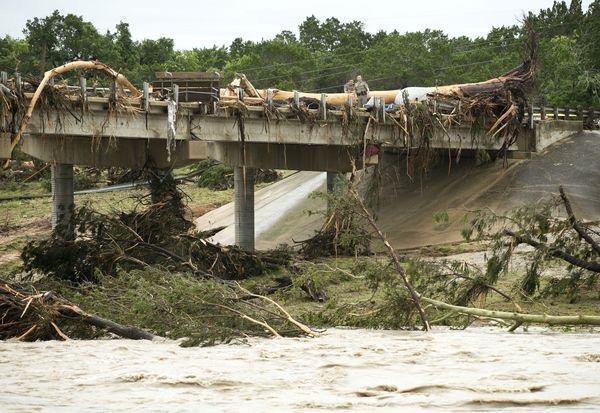
1 Wimberley Witnessing the Flood Date: September 4, 2015 Presented by: John A. Espinoza, PE, CFM;MS Engineering Cindy Engelhardt, PE, CFM; lff Associates Mike Moya, PE, CFM; lff Associates Presentation Outline Wimberley & Home Memorial Weekend Flood Before the flood During the flood After the flood Observations/Comments 1


2 Wimberley Central Texas ys County Population 2,582? Permanent Semi-permanent Tourist Blanco River Spring fed Flood Stage 13 feet Previous record flood 5/28/ feet Home 239 Blanco Drive No Land line phone Cable TV Internet access Private park across the street Blanco River Flow 15 cfs Depth 1 to 2 feet deep Rock bottom Clear water Outside 100 year floodplain 2
3 Before the Flood Rain in Texas - drought ending? Ground saturated Predicting heavy rains Subdivision picnic scheduled for Sunday, May 24 - cancelled Many flood alerts Day of the Flood Saturday Mowed the lawn Started to rain during the afternoon Monitored USGS Gage at RR cfs Received various alerts on cell phone Night of the Flood Noah The BLUR starting around 10:30 pm Getting ready for bed and doorbell Cars moving Lost electricity Limited cell phone coverage Sounds from the river Waves Left Wimberley around 12:30 am Returned the next morning 3


4 Alerts Alerts / warnings throughout the day into the evening 8:23 pm Move to higher ground now. Act quickly to protect your life. 11:24 pm - the Weather Service upgraded the warning to the highest level of flood alert, known as a "flood emergency," for the Blanco River Basin and its tributaries, including Wimberley. "NUMEROUS HOMES HAVE BEEN FLOODED WITH HIGH WATER RESCUES ONGOING," the warning said. "BLANCO RIVER AT WIMBERLEY HAS RISEN TWELVE FEET IN THIRTY MINUTES AND AN ADDITIONAL RISE OF AT LEAST SIX FEET IS EXPECTED IN THE NEXT FEW HOURS. MOVE TO HIGHER GROUND NOW. THIS IS AN EXTREMELY DANGEROUS AND LIFE- THREATENING SITUATION." 4


5 5


6 Prior to the Blanco River Study Update 2005: FEMA Effective Maps 1990 s Corps Model Regression Equation Flows 6


7 Blanco River Major Historical Events Prior to the Blanco River Study Update Current Effective FEMA The Blanco River Study Update Study Partners Guadalupe-Blanco River Authority US Army Corps of Engineers Texas Water Development Board Local Partners 7

 Coordination with Project Stakeholders Basin-wide Terrain Collection of Field Surveys")

8 The Blanco River Study Update Phase 1 (Main Rivers) 460 river miles including the Guadalupe, Blanco, and San Marcos Rivers 6,000 square mile basin Elevation range 0-1,500 7 Counties in the GBRA service area (Victoria, De Witt, Gonzales, Guadalupe, Caldwell, Comal, & ys) Tributaries in the Cities of Luling and Woodcreek The Blanco River Study Update Phase 1 (Main Rivers) Coordination with Project Stakeholders Basin-wide Terrain Collection of Field Surveys Collection of Historical Data Hydrologic Analysis USACE gage frequency analysis Hydraulic Analysis Assessment of Potential Flood Damages Analysis of Potential Flood Reduction Alternatives After the Blanco River 2015 Flood FEMA Advisory Current Effective FEMA 8
9 Prior to the Blanco River 2015 Flood After the Blanco River 2015 Flood After the Blanco River 2015 Flood 9


10 After the Blanco River 2015 Flood FEMA Advisory Base Flood Elevations ABFE Maps ABFE Profiles Depth Grids Areas of Expanded Risk After the flood What do you do first? From FloodSmart Check for damage Remove wet items Plan before you repair File your flood claim Debris Removal Coordinated Debris Types Brush Building materials Household hazard waste (paints, etc.) FEMA Private Property Removal Program Application 10


 R")

11 Health Tetanus shots Mental Health Deaths Damages If your home was flooded If your home was not flooded Post-traumatic Stress Disorder (PTSD) R Volunteers Local Church Businesses Many National Red Cross AmeriCorps Team Rubicon Volunteer Resource Center (VRC) R Donations Businesses Money Clothes Cleaning supplies Tools Water and ice Food and meals R 11


12 Flood Insurance and Loans Register for FEMA Assistance For those with flood insurance Contact insurance agent Preparing a detailed damage estimate Supporting documents Private firms Adjustors For those without flood insurance Low-interest disaster loans from the Small Business Administration (SBA) Trees Many trees Which will survive? Remove or Not Remove Contractors Cleanup Volunteers Private 911 Restoration Roto-Rooter Re-build City Contractor Certification 12


13 Source of Information Media Coverage Websites Facebook s Meetings Highwater Marks Many points Damage Assessments Permits Building Permits (waived fee) Floodplain Development Drones 13


14 Homes 70 homes destroyed 250 to 300 homes damaged Other Flooded Vehicles Property Values Portable Toilets Scams Pets What are the Neighbors Saying I bought my home by the river knowing that this could happen. Even though I have flood insurance, very difficult to receive money. Those without flood insurance may be receiving special rates from some contractors. 14

15 Observations What is the best way to notify people? Volunteers, why so many? How accurate are our models? When did authorities show up? Would a check list helped? Where is the next Wimberley? Meanwhile 15
16 John A. Espinoza, PE, CFM Phone: (210) Cindy Engelhardt, PE, CFM Phone: (512) Mike Moya, PE, CFM Phone: (512)
Passaic River Basin Flood Advisory Commission Report/Status of Recommendations. October 2014 Update
 Passaic River Basin Flood Advisory Commission Report/Status of Recommendations October 2014 Update Passaic River Basin Flood Advisory Commission April 2010: By Executive Order, Governor Christie created
Flood Risk Report. Guadalupe Blanco River Basin. October 2016
 Flood Risk Report Guadalupe Blanco River Basin Upper Guadalupe, Middle Guadalupe, San Marcos, and Lower Guadalupe (HUC8s 12100201-12100204) October 2016 [Type here] [Type here] [Type here] Flood Risk Report
Action Items for Flood Risk Management on Wildcat Creek Interagency success with floodplain management plans and flood forecast inundation maps
 Presentation to USACE 2012 Flood Risk Management and Silver Jackets Joint Workshop, Harrisburg, Pennsylvania Action Items for Flood Risk Management on Wildcat Creek Interagency success with floodplain
Attachment B. King County Flood Control Zone District Work Program
 Attachment B King County Flood Control Zone District Work Program The King County Flood Control Zone District work program is comprised of two major categories: Programmatic Work Program o Flood Preparedness,
Delaware River Basin Commission s Role in Flood Loss Reduction Efforts
 Delaware River Basin Commission s Role in Flood Loss Reduction Efforts There is a strong need to reduce flood vulnerability and damages in the Delaware River Basin. This paper presents the ongoing role
Flood Mitigation Planning at the Texas Water Development Board. Josh Oyer, CFM December 7, 2016
 Flood Mitigation Planning at the Texas Water Development Board Josh Oyer, CFM December 7, 2016 1 Topics TWDB Flood Mitigation Planning overview NFIP Community Assistance Program Federal and State Grants
University Drive Flood Risk Management Project Phase I 58 th Ave S to 500 S of 64 th Ave S City of Fargo Project FM-15-C1
 University Drive Flood Risk Management Project Phase I 58 th Ave S to 500 S of 64 th Ave S City of Fargo Project FM-15-C1 Public Informational Meeting October 15, 2015 6:00 P.M. Overview Flood Risk FEMA
Strategies for Data Sharing
 Proud Titanium Sponsor of the ASFPM 2016 Annual Conference Strategies for Data Sharing Vince Geronimo, PE, CFM Operations Manager, Oakland, CA Krista Bethune Melnar, PE, CFM Technical Director, Water,
Repetitive Loss Area Revisit # 6 Walter Road Area Jefferson Parish
 Repetitive Loss Area Revisit # 6 Walter Road Area Jefferson Parish www.floodhelp.uno.edu Supported by FEMA Acknowledgement The compilation if this report was managed by Erin Patton, CFM, a UNO-CHART Research
King County Flood Control District 2015 Work Program
 Attachment A 2015 Work Plan 10-24-14 King County Flood Control District 2015 Work Program The District work program is comprised of three categories: district oversight and policy development, operations,
FLOOD INSURANCE. Most mortgage lenders require flood insurance for
 FLOOD INSURANCE Anywhere it rains, it can flood. A flood is a general and temporary condition where two or more acres of normally dry land or two or more properties are inundated by water. Many conditions
Flood Plain Management Services (FPMS) Program
 Program") Flood Plain Management Services (FPMS) Program 2016 Winter Stakeholder Partnering Forum March 2016 Mario Beddingfield, P.E., CFM Hydraulic Engineer/FPMS Program Manager H&H/Water Control Branch U.S. Army
Flood Plain Management Services (FPMS) Program 2016 Winter Stakeholder Partnering Forum March 2016 Mario Beddingfield, P.E., CFM Hydraulic Engineer/FPMS Program Manager H&H/Water Control Branch U.S. Army
Oklahoma High Water Marks. CTP Community of Practice April 20, 2017
 Oklahoma High Water Marks CTP Community of Practice April 20, 2017 The Rains Came into Region 6 in May 2015 2 Disaster DR-4222 30 Day Rainfall 3 NOAA Rainfall Amounts / Rainfall Frequency 4 The Rains in
Truckloads (at 25 tons/truck) of building debris 90
 of building debris 90") Marlborough Marlborough is a rural community in Hartford County covering a land area of 23.3 square miles and with an estimated population of 6,410. Elevation ranges from about 160 to 800 feet. The Town
Marlborough Marlborough is a rural community in Hartford County covering a land area of 23.3 square miles and with an estimated population of 6,410. Elevation ranges from about 160 to 800 feet. The Town
BUTTS COUNTY, GEORGIA AND INCORPORATED AREAS
 BUTTS COUNTY, GEORGIA AND INCORPORATED AREAS Butts County Community Name Community Number BUTTS COUNTY (UNICORPORATED AREAS) 130518 FLOVILLA, CITY OF 130283 JACKSON, CITY OF 130222 JENKINSBURG, TOWN OF
Bucks County, PA Flood Risk Review Meeting. November 2014
 Bucks County, PA Flood Risk Review Meeting November 2014 Agenda for Today Risk MAP Program overview Overview of non-regulatory Flood Risk Products and datasets Discuss mitigation action Technical overview
Section 18. Previously Implemented Mitigation Actions
 Section 18. Previously Implemented Mitigation Actions Contents Federal Emergency Management Agency Programs...18-1 U.S. Army Corps of Engineers Studies, Plans and Projects...18-4 State Mitigation Programs...18-5
Avon. Challenges. Estimated Damages from 100- Year Flood
 Avon Avon is a suburban town in north-central Connecticut with a population of about 18,000. It has an average elevation of about 350 ft. The Town encompasses 23.5 square miles, lying entirely within the
Section 19: Basin-Wide Mitigation Action Plans
 Section 19: Basin-Wide Mitigation Action Plans Contents Introduction...19-1 Texas Colorado River Floodplain Coalition Mitigation Actions...19-2 Mitigation Actions...19-9 Introduction This Mitigation Plan,
CRISP COUNTY, GEORGIA AND INCORPORATED AREAS
 CRISP COUNTY, GEORGIA AND INCORPORATED AREAS Community Name Community Number ARABI, CITY OF 130514 CORDELE, CITY OF 130214 CRISP COUNTY (UNINCORPORATED AREAS) 130504 Crisp County EFFECTIVE: SEPTEMBER 25,
Frequently Asked Questions (FAQs)
") FLOODS Floods are one of the most common hazards in the United States. Flood effects can be local, impacting a neighborhood or community, or very large, affecting entire river basins and multiple states.
FLOODS Floods are one of the most common hazards in the United States. Flood effects can be local, impacting a neighborhood or community, or very large, affecting entire river basins and multiple states.
Improving Coordinated Flood Preparedness and Response
 Improving Coordinated Flood Preparedness and Response Illinois Silver Jackets Hank DeHaan Rock Island and Saint Louis Districts October 2011 US Army Corps of Engineers Illinois Silver Jackets Program Illinois
SECTION 9: MAPS AND DATA
 SECTION 9: MAPS AND DATA Contents 9.1. NFIP Maps and Data... 9-2 9.1.1. Adopting and enforcing NFIP floodplain maps and data... 9-2 9.1.2. Adopting and enforcing more restrictive data... 9-2 9.1.3. Annexations...
Floodplain Management Plan
 Floodplain Management Plan CITY OF FORT WORTH TFMA 2016 Spring Conference March 10, 2016 Agenda 1. Fort Worth Higher Standards (NFIP & CRS) 2. Floodplain Management Plan Overview and Results 3. Project
Flood Plain Management Annual Progress Report September 2014
 Flood Plain Management Annual Progress Report September 2014 Flood Plains in the City of Santa Cruz The City of Santa Cruz flood plains encompass the low-lying areas along the San Lorenzo River through
Flood Risk Management and Nonstructural Flood Risk Adaptive Measures
 Flood Risk Management and Nonstructural Flood Risk Adaptive Measures Randall Behm, P.E., CFM USACE-Omaha District Chair, National Nonstructural Flood Proofing Committee US Army Corps of Engineers BUILDING
San Marcos Action Plan Section 1: Needs Assessment July 27, 2016
 Section 1: San Marcos Unmet Needs Assessment Introduction The City of San Marcos, Texas was inundated with historic flash and river flooding in Hays County on two separate occasions within six months of
COLLIER COUNTY FLOODPLAIN MANAGEMENT
 COLLIER COUNTY FLOODPLAIN MANAGEMENT FREQUENTLY ASKED QUESTIONS The following information is based on common questions from the public. If you have a specific question or need further information, please
Volusia County Floodplain Management Plan 2012
 Volusia County Floodplain Management Plan 2012 Introduction The National Flood Insurance Program (NFIP) provides federally supported flood insurance in communities that regulate development in floodplains.
Stoddard County Natural Hazard Mitigation Plan-Five Year Update SECTION 3
 SECTION 3 CITY/COUNTY CAPABILITY ASSESSMENT Mitigation Management Policies This section is an update from the approved Stoddard County 2004 Plan. Specific updates include new information on population
This survey is expected to take approximately 20 minutes and must be completed in one session.
 State Flood Assessment Survey 1 Introduction Thank you for your willingness to participate in this online survey as part of the State Flood Assessment effort. This first step toward developing comprehensive
MSD Quick Buy Program. Lori Rafferty, PE, CFM
 MSD Quick Buy Program Lori Rafferty, PE, CFM March 2015 Ohio River Flooding April 2015 Flooding Substantial Damage Louisville Metro s substantial damage definition was based on a 10-year rolling period
This survey is expected to take approximately 20 minutes and must be completed in one session.
 Introduction Thank you for your willingness to participate in this online survey as part of the State Flood Assessment effort. This first step toward developing comprehensive flood planning for Texas does
FLOODPLAIN MANAGEMENT: A PRESENT AND A 21st CENTURY IMPERATIVE. Gerald E. Galloway, Jr. United States Military Academy
 FLOODPLAIN MANAGEMENT: A PRESENT AND A 21st CENTURY IMPERATIVE Gerald E. Galloway, Jr. United States Military Academy Introduction The principal rivers of the United States and their tributaries have played
THIS PAGE LEFT BLANK INTENTIONALLY
 2 IA 2 Flood THIS PAGE LEFT BLANK INTENTIONALLY 1 Purpose The purpose of this annex is to provide a framework of coordination among agencies to help ensure the safety of life and property during a flood
RiskTopics. Guide to flood emergency response plans September 2017
 RiskTopics Guide to flood emergency response plans September 2017 While floods are a leading cause of property loss, a business owner can take actions to mitigate and even help prevent damage and costly
ASFPM RECOMMENDED TASK FORCE ACTIONS
 Association of State Floodplain Managers, Inc. 2809 Fish Hatchery Road, Suite 204, Madison, WI 53713 Phone: 608-274-0123 Fax: 608-274-0696 Website: www.floods.org Email: asfpm@floods.org Federal Interagency
Georgia Silver Jackets Team
 Georgia Silver Jackets Team 9 th Annual GAFM Technical Conference Jeff Morris GA SJ Collaborator Savannah District, USACE US Army Corps of Engineers SMART GOVERNMENT Integrate and synchronize flood risk
Public Information Meeting Rahway River Basin, New Jersey Flood Risk Management Feasibility Study
 Public Information Meeting Rahway River Basin, New Jersey Flood Risk Management Feasibility Study U.S. Army Corps of Engineers, New York District New Jersey Department of Environmental Protection 11 &
Natural Hazards Mitigation Plan Kankakee County, Illinois Executive Summary
 1. Introduction Natural Hazards Mitigation Plan Kankakee County, Illinois Executive Summary Kankakee County is subject to natural hazards that threaten life, safety, health, and welfare and cause extensive
IN THE LITTLE APPLE A PRESENTATION FOR THE 2017 ASFPM ANNUAL CONFERENCE IN KANSAS CITY, MO, MANAGING FLOOD RISK IN THE HEARTLAND
 A PRESENTATION FOR THE 2017 ASFPM ANNUAL CONFERENCE IN KANSAS CITY, MO, MANAGING FLOOD RISK IN THE HEARTLAND NONSTRUCTURAL 237 217 200 ASSESSMENT 80 252 237 217 200 119 174 237 217 200 27.59 IN THE LITTLE
THE $64,000 FLOOD INSURANCE BILL
 THE $64,000 FLOOD INSURANCE BILL GEORGIA ASSOCIATION OF FLOODPLAIN MANAGERS 9 TH ANNUAL TECHNICAL CONFERENCE Patrick Gervais, PE, CFM A CASE STUDY IN FLOOD INSURANCE This is a true story that happened
Flood Hazards and Flood Risk, the Impact of a Changing Climate
 Flood Hazards and Flood Risk, the Impact of a Changing Climate Sally A. McConkey, P.E. CFM, D. WRE. Illinois State Water Survey June 14, 2017 Topics ISWS Coordinated Hazard Assessment and Mapping Program
Federal Flood Risk Management Standards. An Update on Federal Flood Resilience Standards
 Federal Flood Risk Management Standards An Update on Federal Flood Resilience Standards Purpose of Today s Briefing Facilitate the understanding of Executive Order (E.O.)13690 and its implementation Discuss
Campbell County Parks and Recreation Temporary Use Permit Application
 Campbell County Parks and Recreation Temporary Use Permit Application To secure your permit, please complete the following application. Read and initial next to every item on the Temporary Use Rules and
EMERGENCY ACTION PLAN GUIDEBOOK
 EMERGENCY ACTION PLAN GUIDEBOOK Presented by: Terry Zien and Bonnie Greenleaf US Army Corps of Engineers Background Purpose Overview of Guidebook Discussion of Key Chapters Minnesota Silver Jackets Natural
Upper Joachim Creek Public Survey on Potential Flood Risk Reduction
 Upper Joachim Creek Public Survey on Potential Flood Risk Reduction This survey is intended to help the interagency planning committee to receive public feedback on specific flood risk reduction techniques,
Ocean City Office of Emergency Management. Environmental Commission Lecture Series October 24, 2017
 Ocean City Office of Emergency Management Environmental Commission Lecture Series October 24, 2017 FEMA Region II Flood Insurance Rate Maps (FIRM s) Adopted as of 10/5/2017 All of Cape May County adopted
VOLUME 1 OF 1 GONZALES COUNTY, TEXAS AND INCORPORATED AREAS GONZALES COUNTY, UNINCORPORATED AREAS
 VOLUME 1 OF 1 GONZALES COUNTY, TEXAS AND INCORPORATED AREAS COMMUNITY NAME GONZALES COUNTY, UNINCORPORATED AREAS COMMUNITY NUMBER 480253 GONZALES, CITY OF 480254 NIXON, CITY OF 481114 SMILEY, CITY OF*
In 1993, spring came in like a lion, but refused
 36 UNIVERSITIES COUNCIL ON WATER RESOURCES ISSUE 130, PAGES 36-40, MARCH 2005 FEMA and Mitigation: Ten Years After the 1993 Midwest Flood Norbert Director of Federal Insurance and Mitigation Division Federal
July 31, 2017 NFIP Flood Map Open House Flood Maps 101 Flood Mapping acronyms History of the NFIP Flood Mapping Updates Flood Insurance Fairhope,
 July 31, 2017 NFIP Flood Map Open House Flood Maps 101 Flood Mapping acronyms History of the NFIP Flood Mapping Updates Flood Insurance Fairhope, Alabama Flood Maps Fairhope Permitting Jurisdiction Coastal
SOUTH CENTRAL REGION MULTI-JURISDICTION HAZARD MITIGATION PLAN. Advisory Committee Meeting September 12, 2012
 SOUTH CENTRAL REGION MULTI-JURISDICTION HAZARD MITIGATION PLAN Advisory Committee Meeting September 12, 2012 AGENDA FOR TODAY Purpose of Meeting Engage All Advisory Committee Members Distribute Project
Northwest Flood Fight Workshops
 Northwest Flood Fight Workshops September 24, 2014 IWR Webinar D. Leslie Miller, P.E. (Les) Flood Preparedness Program Manager US Army Corps of Engineers, Portland District US Army Corps of Engineers Welcome
Individual Assistance Preliminary Damage Assessment. Train the Trainer
 Individual Assistance Preliminary Damage Assessment Train the Trainer 1 2 DAMAGE ASSESSMENT What is it? The systematic process of determining and appraising the extent of loss, suffering and/or harm to
Frequently Asked Questions Oxbow / Hickson / Bakke Ring Levee Option
 Frequently Asked Questions Oxbow / Hickson / Bakke Ring Levee Option October 16, 2012 Q1. Why has the position on a ring-levee changed? The feasibility study recommended buy-outs for areas with staging
Flooding and the Public: Experiences from SC flooding events in 2015 and 2016
 Flooding and the Public: Experiences from SC flooding events in 2015 and 2016 Maria Cox Lamm, CFM State Coordinator SCDNR Flood Mitigation Program www.dnr.sc.gov/flood Public Reaction to Flooding Would
Erie County Flood Risk Review Meeting. January 18, 2018
 Erie County Flood Risk Review Meeting January 18, 2018 Agenda The value of updated flood maps for your community Review updated flood-risk data and important next steps in the Risk MAP process Increasing
GUADALUPE-BLANCO RIVER AUTHORITY Minutes of the Board of Directors
 GUADALUPE-BLANCO RIVER AUTHORITY Minutes of the Board of Directors The Board of Directors of the Guadalupe-Blanco River Authority met in a regular monthly meeting on December 12, 2018, at the GBRA William
National Coastal Outreach
 National Coastal Outreach Answering Tough Questions June 11, 2013 Why Focus on Coastal Flood Risk? 120,475,000 people or 39% of the U.S. population live in counties subject to the 1% annual chance coastal
Michael Taylor, PE, CFM Project Manager, AECOM August 25, 2015
 Promoting FEMA s Flood Risk Products in the Lower Levisa Watershed Michael Taylor, PE, CFM Project Manager, AECOM August 25, 2015 Agenda Study Background Flood Risk Product Overview AOMI and Mitigation
Chesapeake officials: Report home, business damage to the city right away
 If you were affected by Hurricane Mathew here are a few suggestions by the City of Virginia Beach. If you do not live in Virginia Beach go to your cities government page to report damages or call the appropriate
Dunklin County Natural Hazard Mitigation Plan-Five Year Update SECTION 3
 CITY/COUNTY CAPABILITY ASSESSMENT DUNKLIN COUNTY Mitigation Management Policies This section is an update from the approved Dunklin County 2004 Plan. Specific updates include new information on population
Situation: the need for non-structural flood risk reduction measures
 Evaluating benefits of non-structural measures in flood risk management feasibility studies At left: Example of a house on an open foundation Source Asheville, NC (undated) By Steve Cowdin, CFM; Natalie
Flood Vulnerability Assessment for Critical Facilities. Molly Woloszyn Lisa Graff, GISP, CFM
 Flood Vulnerability Assessment for Critical Facilities Molly Woloszyn Lisa Graff, GISP, CFM 2011 University of Illinois Board of Trustees. All rights reserved. For permission information, contact the Illinois
CDBG-DR, BW-12, CRS and Dauphin County, PA: What do they have in common? 2015 ASFPM Annual Conference
 CDBG-DR, BW-12, CRS and Dauphin County, PA: What do they have in common? 2015 ASFPM Annual Conference June 3, 2015 Today's Speaker Rob Flaner Hazard Mitigation Program Manager, Tetra Tech, Inc. Over 25
Habitat for Humanity
 Habitat for Humanity Where: Lenwood Heights, 259 S Acme Rd, 78237 When: Sat., June 23, 2018 You can drive there see instructions attached. It you need a ride we can carpool from St Padre Pio, arrive at
DECATUR COUNTY, GEORGIA AND INCORPORATED AREAS
 DECATUR COUNTY, GEORGIA AND INCORPORATED AREAS Community Name Community Number ATTAPULGUS, CITY OF 130541 BAINBRIDGE, CITY OF 130204 BRINSON, TOWN OF 130670 CLIMAX, CITY OF 130542 DECATUR COUNTY (UNINCORPORATED
Community Development Department
 Community Development Department Ryan DeVore, Interim Director of Community Development Scot Mende, Principal Planner Bill Busath, Interim Director of Utilities Connie Perkins, Senior Engineer, Floodplain
MONROE COUNTY, GEORGIA
 MONROE COUNTY, GEORGIA AND INCORPORATED AREAS Monroe County Community Name Community Number *CULLODEN, CITY OF 130543 FORSYTH, CITY OF 130359 MONROE COUNTY 130138 (UNINCORPORATED AREAS) *No Flood Hazard
U.S. Army Corp of Engineers
 U.S. Army Corp of Engineers PL 84-99 Levee Inspections and Levee Certification Hank DeHaan Rock Island District March 9, 2011 US Army Corps of Engineers U.S. Army Corps of Engineers Flood Damage Reduction
Water Levels Preparedness April 14, 2018
 Water Levels Preparedness April 14, 2018 Where we are today Current Conditions Current Weekly Forecast Current Weekly Forecast Current Monthly Forecast Plan Foreword At approximately 246 AND if forecasts
Natural Hazards Risks in Kentucky. KAMM Regional Training
 Natural Hazards Risks in Kentucky KAMM Regional Training Floodplain 101 Kentucky has approximately 92,000 linear miles of streams and rivers Approximately 31,000 linear miles have mapped flood hazards
ADVISORY BASE FLOOD ELEVATIONS (ABFEs)
") The Department of Homeland Security s Federal Emergency Management Agency is committed to helping communities that were impacted by Hurricanes Katrina and Rita rebuild safer and stronger. Following catastrophic
The Department of Homeland Security s Federal Emergency Management Agency is committed to helping communities that were impacted by Hurricanes Katrina and Rita rebuild safer and stronger. Following catastrophic
Vision to Action: Creating and Using a Flood Risk Assessment for Identifying Mitigation Options
 Vision to Action: Creating and Using a Flood Risk Assessment for Identifying Mitigation Options Lisa Graff, CFM, GISP Clayton Ballerine, CFM Brad McVay, CFM, GISP University of Illinois Prairie Research
Thurston County, WA Flood Hazard Mitigation Plan Annual Progress Report CRS Activity 510
 Thurston County, WA Flood Hazard Mitigation Plan Annual Progress Report CRS Activity 510 Reporting Period: ctober 1, 2014 to September 30, 2015 Background: Thurston County developed a flood hazard mitigation
Interagency Nonstructural Flood Risk Management Workshop. Carey Johnson Kentucky Division of Water
 Interagency Nonstructural Flood Risk Management Workshop Carey Johnson Kentucky Division of Water Nonstructural Flood Risk Management Nonstructural floodproofing Elevation Relocation Buyout/acquisition
ECONOMIC EVALUATION OF FLOODPLAIN MANAGEMENT AND FLOOD MITIGATION
 ECONOMIC EVALUATION OF FLOODPLAIN MANAGEMENT AND FLOOD MITIGATION CITY OF BIRMINGHAM, ALABAMA EDWIN REVELL, CFM FLOOD PLAIN ADMINISTRATOR DENISE PRUITT, CFM PROJECT PLANNER PRESENTATION OUTLINE 1. BACKGROUND/LOCATION
10/23/2014. Presented by: Erike Young, MPPA, CSP, ARM-E. Public Sector Disaster Planning/Emergency Response
 Presented by: Erike Young, MPPA, CSP, ARM-E 1 Public Sector Disaster Planning/Emergency Response 2 1 3 Disaster defined as an accidental or intentional event that causes significant disruption to an entity
STORM UPDATE WHO TO CALL? For more Hurricane Preparedness guides and resources visit:
 STORM UPDATE The National Hurricane Center (NHC) has announced that Hurricane Irma will possibly affect weather conditions in our area. Hurricanes have the potential to produce storm surge, gusty winds,
Natural Hazards Mitigation Plan. Executive Summary
 Natural Hazards Mitigation Plan Executive Summary 1. Introduction Kane County Illinois, is subject to natural hazards that threaten life and health and have caused extensive property damage. Floods struck
FREQUENTLY ASKED QUESTION ABOUT FLOODPLAINS Michigan Department of Environmental Quality
 FREQUENTLY ASKED QUESTION ABOUT FLOODPLAINS Michigan Department of Environmental Quality WHAT IS A FLOOD? The National Flood Insurance Program defines a flood as a general and temporary condition of partial
Mapping Flood Risk in the Upper Fox River Basin:
 Mapping Flood Risk in the Upper Fox River Basin: Vulnerable Populations and Adverse Health Effects Presented by: Angelina Hanson STUDY AREA: Wisconsin's Upper Fox River Basin Total Population 139,309.
Flood Risk Assessment in the
 Georgia Flood M.A.P. Program Flood Risk Assessment in the Upper Chattahoochee h h River Basin GAFM Annual Conference March 28, 2012 Agenda Map Mod to Risk MAP (Georgia Flood M.A.P.) transition Flood Risk
Using Non-Regulatory RiskMAP Products in Floodplain Management. Ferrin Affleck, PE, CFM, Water Resources Engineer Project Manager Atkins
 Using Non-Regulatory RiskMAP Products in Floodplain Management Ferrin Affleck, PE, CFM, Water Resources Engineer Project Manager Atkins 1 Goal of this Presentation Inform Peak interest Stimulate creativity
Using GISWeb to Determine Your Property s Flood Zone
 Using GISWeb to Determine Your Property s Flood Zone 1. In a new browser window, go to http://www.co.santacruz.ca.us/departments/geographicinformationsystemsgis.aspx 2. Click on GISWeb - GIS Mapping Application
Dealing With Unnumbered A Zones in Maine Floodplain Management
 Dealing With Unnumbered A Zones in Maine Floodplain Management The following is a list of acceptable methods that the State Floodplain Management Coordinator and the Federal Emergency Management Agency
ANNEX B: TOWN OF BLUE RIVER
 ANNEX B: TOWN OF BLUE RIVER B.1 Community Profile Figure B.1 shows a map of the Town of Blue River and its location within Summit County. Figure B.1. Map of Blue River Summit County (Blue River) Annex
Existing Strategies. Challenges
 Enfield The Town of Enfield encompasses 33.4 square miles with an estimated population of approximately 44,600 people. Enfield is located along the Massachusetts border and is both in the main stem of
Requirements for Mapping Levees Complying with Section of the NFIP Regulations
 FACT SHEET Requirements for Mapping Levees Complying with Section 65.10 of the NFIP Regulations As part of a mapping project, it is the levee owner s or community s responsibility to provide data and documentation
King County Flood Control District Flood Risk Reduction Work Program and Accomplishments
 King County Flood Control District Flood Risk Reduction Work Program and Accomplishments Brian Murray Water and Land Resources Division April 26, 2016 Department of Natural Resources and Parks Water and
Registration Intake. Sequence of Delivery INTRODUCTION TO INDIVIDUAL ASSISTANCE (IA)
") INTRODUCTION TO INDIVIDUAL ASSISTANCE (IA) Visual 1-1 Registration Intake Phone: 800-621-FEMA (3362) 800-462-7285 TDD Online: www.disasterassistance.gov Visual 1-2 Sequence of Delivery Visual 1-3 1 Mass
INTRODUCTION TO INDIVIDUAL ASSISTANCE (IA) Visual 1-1 Registration Intake Phone: 800-621-FEMA (3362) 800-462-7285 TDD Online: www.disasterassistance.gov Visual 1-2 Sequence of Delivery Visual 1-3 1 Mass
QUESTIONS & ANSWERS Wildfire and Flooding Frequently Asked Questions for First Nations Communities
 QUESTIONS & ANSWERS Wildfire and Flooding Frequently Asked Questions for First Nations Communities Updated: September 24, 2018 Flooding Information 1. Who should I contact about an emergency such as a
3DEP Coalition Meeting. Kevin T. Gallagher Associate Director, Core Science Systems November 10, 2016
 + 3DEP Coalition Meeting Kevin T. Gallagher Associate Director, Core Science Systems November 10, 2016 + 2 3DEP Status 2023 + 3 3D Elevation Program (3DEP) Mission Critical Applications Geologic Hazards
Authors: Terry Zien, Brian Rast and the Silver Jackets Co presenters: Brian Rast, Dave Lupardus and Frank Dolan
 Authors: Terry Zien, Brian Rast and the Silver Jackets Co presenters: Brian Rast, Dave Lupardus and Frank Dolan http://www.mvp.usace.army.mil/missions/civilworks/floodriskm anagement/emergencyactionplanguidebook.aspx
Flood Risk Review (FRR) Meeting. Cumberland County, Pennsylvania Carlisle, Pennsylvania December 5, 2016
 Meeting. Cumberland County, Pennsylvania Carlisle, Pennsylvania December 5, 2016") Flood Risk Review (FRR) Meeting Cumberland County, Pennsylvania Carlisle, Pennsylvania December 5, 2016 Why are we here today? The Flood Insurance Study (FIS) report and Flood Insurance Rate Maps (FIRMs)
Flood Risk Review (FRR) Meeting Cumberland County, Pennsylvania Carlisle, Pennsylvania December 5, 2016 Why are we here today? The Flood Insurance Study (FIS) report and Flood Insurance Rate Maps (FIRMs)
Things You Should Know About Flood Protection
 Things You Should Know About Flood Protection Because the is located in a unique geographical area; it is particularly susceptible to flooding from major rain events and storm surge. The City is surrounded
LOCAL HAZARD MITIGATION PLAN REVIEW FEMA REGION VI AND STATE OF TEXAS
 LOCAL HAZARD MITIGATION FEMA REGION VI AND STATE OF TEXAS Instructions for using the attached Crosswalk Reference Document for Review and Submission of Local Mitigation Action Plans to the State Hazard
September Three Steps for Implementing a Complete Flood Management Plan
 September 2016 Three Steps for Implementing a Complete Flood Management Plan Copyright 2016 Esri All rights reserved. Printed in the United States of America. The information contained in this document
Silver Jackets - Flood Risk Management Program
 COOPERATING TECHNICAL PARTNER INFORMATION EXCHANGE Silver Jackets - Flood Risk Management Program August 31, 2017 Association of State Floodplain Managers AUDIO AND WEB SETTINGS Your Participation Open
CONTINUING AUTHORITIES PROJECT (CAP) Federal Interest Determination
 Federal Interest Determination") Date: 8 May 2013 Division: Great Lakes and Ohio River Division District: Nashville District CONTINUING AUTHORITIES PROJECT (CAP) Federal Interest Determination 1. Project: Cumberland River, Metropolitan
Date: 8 May 2013 Division: Great Lakes and Ohio River Division District: Nashville District CONTINUING AUTHORITIES PROJECT (CAP) Federal Interest Determination 1. Project: Cumberland River, Metropolitan