Floodplain Management Plan
|
|
|
- Samuel Knight
- 6 years ago
- Views:
Transcription
1 Floodplain Management Plan CITY OF FORT WORTH TFMA 2016 Spring Conference March 10, 2016
2 Agenda 1. Fort Worth Higher Standards (NFIP & CRS) 2. Floodplain Management Plan Overview and Results 3. Project Timeline 4. Wrap Up
3 Fort Worth Higher Floodplain Standards (NFIP & CRS)
4 Fort Worth Higher Standards Work Higher Standards throughout NFIP participation 100-year (1.0% chance) design storm, fully-developed drainage basins, 2.0 feet of freeboard, Corridor Development Certificate. Claim reduction since NFIP participation (1980): 323 pre-firm claims for $3,414,216 in damages; 38 post-firm claims for $553,400 in damages; 88% reduction in claims, 84% reduction in damages. Community Rating System rewards higher standards with lower flood insurance premiums.

5 Community Rating System (CRS) Voluntary incentivized program that involved communities earning points toward higher CRS Classifications and, in turn, policy holders can receive reductions in their premiums Fort Worth began participating in 2012
6 NFIP Community Rating System Communities complete creditable activities to reach a higher classification Fort Worth Wichita Falls Austin Benbrook Burleson Dallas Grand Prairie Houston
7 Fort Worth Stormwater Utility 2006: Stormwater Utility created Monthly stormwater utility fee Limited Annual Operating Budget Over $1 billion in stormwater needs
8 Stormwater Utility Facts Population: 781,000 Accounts: 200,000 Service Area: 350 square miles Infrastructure: 947 miles pipes 1028 miles open channel
9 Fort Worth Stormwater Utility
10 Floodplain Management Plan
: Introduction to FMP Hazard Assessment & Mitigation")
11 Step 1:Organize Stakeholder Planning Group to Guide Plan Development Public & City Representatives Planning Meetings (3): Introduction to FMP Hazard Assessment & Mitigation Activities Draft Plan


12 Step 2: Public Involvement 2 Public Meetings Runoff Rundown Social Media MySidewalk Survey Tool fort-worth-tx


13 Public Input to Date 26 attendees at first public meeting 80+ responses to MySidewalk Survey Questions
14 Step 3:Coordinate with Other Agencies Review of existing studies and plans Coordinating with communities and other agencies USGS TRWD USACE NWS
15 Step 4:Assess the Hazard Where is the flooding? Assessment of flood hazards Map of known flood hazards Description of known flood hazard Discussion of past floods Assessment of less frequent floods Inventory of levees and dams that would result in flooding Map of affected areas and lay term summary Assessment of areas likely to flood (floodplain & outside floodplain)
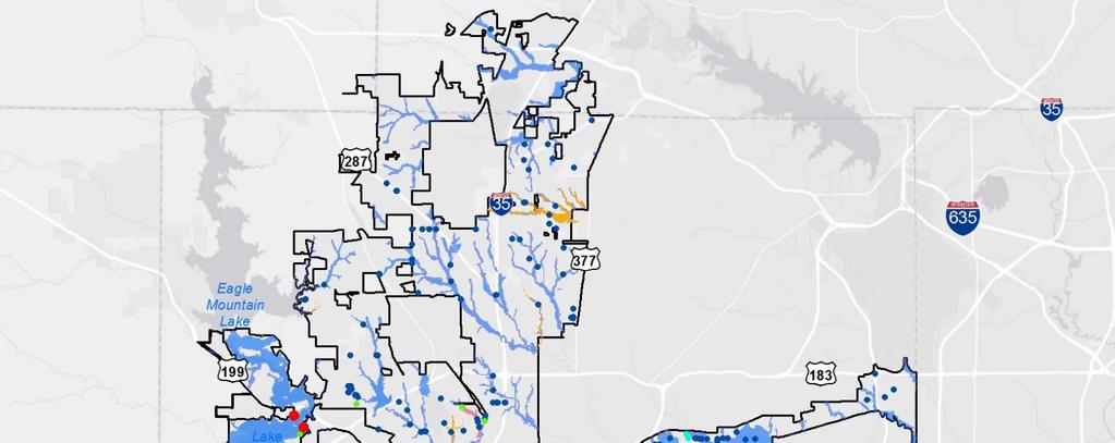
16 Hazard Assessment
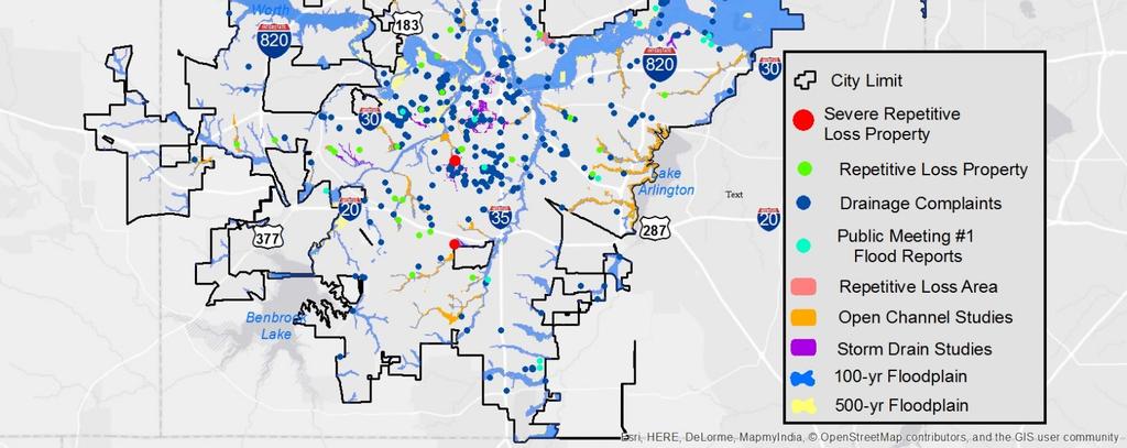
17 Step 5: Assess the Problem We know where the hazard is, but what is the impact? Description of the impact of the hazards on: Life, safety, health, procedures for warning and evacuation Public health including health hazards to floodwaters and mold Critical facilities and infrastructure The community s economy and tax base Number and type of affected buildings Review of all damaged buildings/flood insurance claims All addresses of properties that have received flood insurance claims, even single occurrences

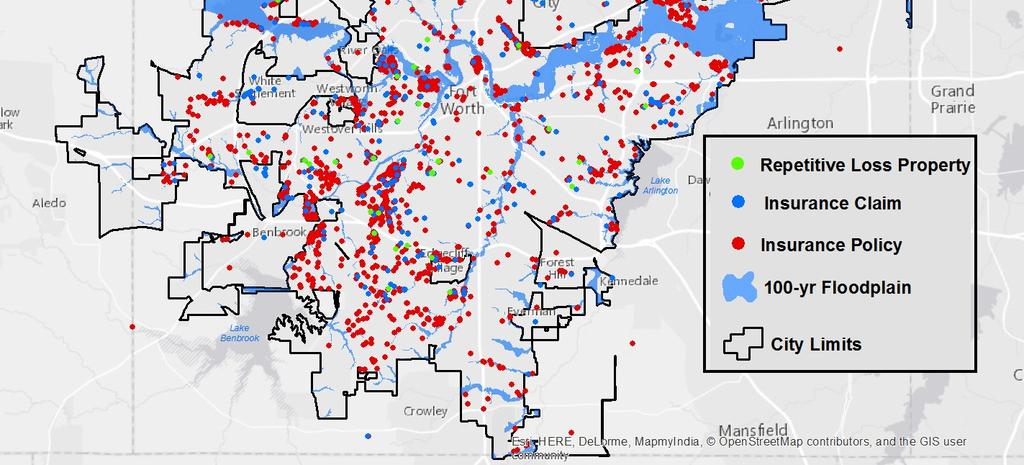
18 Flood Insurance Map


19 Economic Loss Map $1.5B Total Economic Loss
20 The Insurance & Risk Gap Not every structure in the FEMA floodplain, and not every structure at risk has flood insurance Estimate of 5,700 structures in the FEMA floodplain: 4,600 residential; 1,100 non-residential Approximately 26,382 residents at risk of being displaced $695M in uninsured residential risk $455M in uninsured non-residential risk No estimate of risk outside the FEMA floodplain
21 Step 6:FMP Goals 1. Protect the health and safety of the public (links to City goal 1, 5) 2. Facilitate sustainable growth (links to City goals 4, 5) 3. Educate the public about flood risk mitigation and safety in Fort Worth (links to City goal 1) 4. Reduce the adverse effects of flood events (links to City goal 1, 2, 3, 4, 5) 5. Develop mitigation actions for regional solutions and regulatory issues (links to City goal 5)
22 Step 7:Review Possible Activities Preventive activities (zoning, floodplain regulations, building codes, subdivision ordinances) Regulatory standard sufficient for current and future conditions Natural floodplain function protection activities Property protection and mitigation activities Emergency service activities Structural projects Public information activities

23 Step 7: Review Possible Activities City discussion Planning group discussion MySidewalk Questions S TO R M WAT E R M I S S I O N : TO P R OT EC T P EO P L E A N D P R O P E RT Y F R O M H A R M F U L S TO R M WAT E R R U N O F F

24 Step 8:Draft Action Plan Actions in Six Mitigation Categories 1. Preventative Activities 2. Property Protection 3. Natural Resource Protection 4. Emergency Services 5. Structural Projects 6. Public Outreach
25 Step 8:Draft Action Plan


26 Step 9:Adopt the Plan Plan and amendments are adopted by Council Incorporated into existing planning mechanisms (HMAP, Comprehensive plan)
27 Step 10: Implement, Evaluate and Revise Procedures established for monitoring plan implementations, checking on progress, and recommending revisions
28 Project Timeline
29 Schedule of FMP Floodplain Management Plan Tasks Month 2015 May Jun Jul Aug Sep Oct Committee Organization and Data Collection Hazard Assessment Mitigation Strategy and Action Plan Draft FMP Public Comment Period Committee Meeting Public Meeting
30 Wrap-up
31 Next Steps ISO visit in April Council Adoption Process CRS submittal and review
32 CRS Points Self Scoring: 310 points (Original goal: 250 points) RLAA: 140 points possible Potential total: 450 points 500 points per classification
33 Key Takeaways Higher standards work Majority of flooding is outside of FEMA floodplain in Fort Worth FMP helps prioritize flood mitigation efforts and provides CRS credit
34 Q&A Clair Davis, P.E., CFM Scott Hubley, P.E., CFM Katie Hogan, P.E., CFM
35 Slides not used

36 Comment Cards We would like your input Collecting information to help the community & develop a comprehensive plan Translation services available
37 National Flood Insurance Program Founded in 1968 to provide two main functions Providing insurance for property owners Guide communities in adopting and enforcing floodplain management regulations Average policy premium in 2012 was $650 per year Paid out more than $7.7 billion in 2012 Fort Worth joined NFIP in 1980
38 National Flood Insurance Program
39 How can you help? Comment on the plan Tell us what is important to you Participation at committee meetings Your comments informed the actions (e.g. enhance sandbag program)
40 Step 8:Draft Action Plan Property Protection 1. Continue ongoing property protection activities 2. Increase Flood Insurance Participation 3. Encourage Relocation, Acquisition, and Building Elevation projects
41 Step 8:Draft Action Plan Natural Resource Protection 1. Continue ongoing natural resource protection activities 2. Maintain current natural preserved areas 3. Develop regulations based on natural area preservation 4. Expand water quality regulations and education
42 Step 8:Draft Action Plan Emergency Services 1. Continue ongoing emergency services 2. Expand flood warning system 3. Improve hazard response operations
43 Step 8:Draft Action Plan Structural Projects 1. Continue ongoing structural projects 2. Complete storm drain capital projects 3. Complete detention capital projects 4. Reduce flood risk at hazardous road crossings 5. Pursue partnerships to complete stormwater projects
44 Step 8:Draft Action Plan Public Information Activities 1. Continue ongoing public information activities 2. Create targeted outreach programs 3. Provide additional outreach to community regarding flood risk 4. Improve education of flood risk to schools and youth 5. Educate the public about environmental protection 6. Provide technical assistance to the public on how to interpret flood risk
Action Items for Flood Risk Management on Wildcat Creek Interagency success with floodplain management plans and flood forecast inundation maps
 Presentation to USACE 2012 Flood Risk Management and Silver Jackets Joint Workshop, Harrisburg, Pennsylvania Action Items for Flood Risk Management on Wildcat Creek Interagency success with floodplain
CITY OF PLANTATION ENGINEERING DEPARTMENT INTEROFFICE MEMORANDUM NO
 CITY OF PLANTATION ENGINEERING DEPARTMENT INTEROFFICE MEMORANDUM NO. 2013-003 DATE: October 22, 2012 TO: Mayor and Members of City Council FROM: Brett W. Butler, PE, CFM City Engineer SUBJECT: CRS Program
10/5/2015. What Makes a Sound Floodplain Management Program? What are the Flood Problems in your Community?
 The Community Rating System (CRS) and Hazard Mitigation Planning Preparing Your Community Through Common Program Goals September 3, 2015 What Makes a Sound Floodplain Management Program? Know your community
Land Economics 94:2, May 2018 Flood Risk, Local Hazard Mitigation, and the Community Rating System of NFIP, by Jingyuan Li and Craig E.
 APPENDIX Table A1. Community Rating System Activities and Credit Scores Series Description Creditable Activities Points 1. Elevation Certificates 162 Public Information (300) CRS will credit those local
Community Rating System. National Flood Insurance Program
 National Flood Insurance Program Community Rating System A Local Official s Guide to Saving Lives Preventing Property Damage Reducing the Cost of Flood Insurance FEMA B-573 / May 2015 How the Community
FEMA FLOOD MAPS Public Works Department Stormwater Management Division March 6, 2018
 FEMA FLOOD MAPS Public Works Department Stormwater Management Division March 6, 2018 Presentation Overview FEMA National Flood Insurance Program (NFIP) FEMA Community Rating System (CRS) Flood Insurance
CRS State Profile: Wyoming
 CRS State Profile: Wyoming This is a profile for communities in your state that are participating in the Community Rating System (CRS). This profile is intended to provide information to the State NFIP
Michael Taylor, PE, CFM Project Manager, AECOM August 25, 2015
 Promoting FEMA s Flood Risk Products in the Lower Levisa Watershed Michael Taylor, PE, CFM Project Manager, AECOM August 25, 2015 Agenda Study Background Flood Risk Product Overview AOMI and Mitigation
CRS State Profile: Texas
 CRS State Profile: Texas This is a profile for communities in your state that are participating in the Community Rating System (CRS). This profile is intended to provide information to the State NFIP Coordinator
CRS State Profile: Alaska
 CRS State Profile: Alaska This is a profile for communities in your state that are participating in the Community Rating System (CRS). This profile is intended to provide information to the State NFIP
National Flood Insurance Program (NFIP) Community Rating System (CRS) Together North Jersey Resilient Task Force Meeting
 Community Rating System (CRS) Together North Jersey Resilient Task Force Meeting") National Flood Insurance Program (NFIP) Community Rating System (CRS) Together North Jersey Resilient Task Force Meeting April 3, 2017 Marianne Luhrs, AICP FEMA R2 CRS Coordinator Visual Intro-1 CRS Program
National Flood Insurance Program (NFIP) Community Rating System (CRS) Together North Jersey Resilient Task Force Meeting April 3, 2017 Marianne Luhrs, AICP FEMA R2 CRS Coordinator Visual Intro-1 CRS Program
5/25/2017. So why don t more communities participate in the Community Rating System (CRS)? Agenda. What is CRS? Community Rating System
? Agenda. What is CRS? Community Rating System") Floodplain Management Activities Flood Insurance Rates So why don t more communities participate in the Community Rating System (CRS)? Texas Floodplain Management Association 29 th Annual Spring Conference
Floodplain Management Activities Flood Insurance Rates So why don t more communities participate in the Community Rating System (CRS)? Texas Floodplain Management Association 29 th Annual Spring Conference
CRS State Profile: Connecticut
 CRS State Profile: Connecticut This is a profile for communities in your state that are participating in the Community Rating System (CRS). This profile is intended to provide information to the State
ECONOMIC EVALUATION OF FLOODPLAIN MANAGEMENT AND FLOOD MITIGATION
 ECONOMIC EVALUATION OF FLOODPLAIN MANAGEMENT AND FLOOD MITIGATION CITY OF BIRMINGHAM, ALABAMA EDWIN REVELL, CFM FLOOD PLAIN ADMINISTRATOR DENISE PRUITT, CFM PROJECT PLANNER PRESENTATION OUTLINE 1. BACKGROUND/LOCATION
What are the savings? An Assessment of the National Flood Insurance Program s (NFIP) Community Rating System (CRS)
 Community Rating System (CRS)") What are the savings? An Assessment of the National Flood Insurance Program s (NFIP) Community Rating System (CRS) Ajita Atreya Postdoctoral Research Fellow Wharton Risk Management and Decision Processes
What are the savings? An Assessment of the National Flood Insurance Program s (NFIP) Community Rating System (CRS) Ajita Atreya Postdoctoral Research Fellow Wharton Risk Management and Decision Processes
CRS State Profile: Massachusetts
 CRS State Profile: Massachusetts This is a profile for communities in your state that are participating in the Community Rating System (CRS). This profile is intended to provide information to the State
CRS State Profile: Indiana
 CRS State Profile: Indiana This is a profile for communities in your state that are participating in the Community Rating System (CRS). This profile is intended to provide information to the State NFIP
CRS State Profile: Ohio
 CRS State Profile: Ohio This is a profile for communities in your state that are participating in the Community Rating System (CRS). This profile is intended to provide information to the State NFIP Coordinator
MUNICIPAL LAND USE STRATEGIES for Improving Flood Resilience
 MUNICIPAL LAND USE STRATEGIES for Improving Flood Resilience Strategy for a Flood Resistant Southern Tier Central Region (LWRP project) This presentation was prepared by Southern Tier Central Regional
University Drive Flood Risk Management Project Phase I 58 th Ave S to 500 S of 64 th Ave S City of Fargo Project FM-15-C1
 University Drive Flood Risk Management Project Phase I 58 th Ave S to 500 S of 64 th Ave S City of Fargo Project FM-15-C1 Public Informational Meeting October 15, 2015 6:00 P.M. Overview Flood Risk FEMA
ASFPM Partnerships for Statewide Mitigation Actions. Alicia Williams GIS and HMP Section Manager, Amec Foster Wheeler June 2016
 ASFPM Partnerships for Statewide Mitigation Actions Alicia Williams GIS and HMP Section Manager, Amec Foster Wheeler June 2016 Summary The Concept Leveraging Existing Data and Partnerships to reduce risk
ROI for Joining CRS. Floodplain Management Association Conference. Sacramento, CA. September 2016
 ROI for Joining CRS Floodplain Management Association Conference Sacramento, CA September 2016 Agenda Joining CRS Challenges ROI Tips Wrap Up 1 FMA Conference What is CRS? Community Rating System Voluntary
COMMUNITY RATING SYSTEM (CRS) October 28, 2013
 October 28, 2013") COMMUNITY RATING SYSTEM (CRS) October 28, 2013 SUE K. HOPFENSPERGER, CFM ISO/CRS SPECIALIST ASSOCIATION OF STATE FLOODPLAIN MANAGER CERTIFIED FLOODPLAIN MANAGER Location: Fernandina Beach, FL INSURANCE
COMMUNITY RATING SYSTEM (CRS) October 28, 2013 SUE K. HOPFENSPERGER, CFM ISO/CRS SPECIALIST ASSOCIATION OF STATE FLOODPLAIN MANAGER CERTIFIED FLOODPLAIN MANAGER Location: Fernandina Beach, FL INSURANCE
CITY OF VESTAVIA HILLS
 CITY OF VESTAVIA HILLS FLOODPLAIN MANAGEMENT PLAN KICK-OFF MEETING MARCH 10, 2015 FLOODPLAIN MANAGEMENT PLANNING COMMITTEE Representative of the following categories Preventive Maintenance (e.g., codes)
Flood Plain Management Services (FPMS) Program
 Program") Flood Plain Management Services (FPMS) Program 2016 Winter Stakeholder Partnering Forum March 2016 Mario Beddingfield, P.E., CFM Hydraulic Engineer/FPMS Program Manager H&H/Water Control Branch U.S. Army
Flood Plain Management Services (FPMS) Program 2016 Winter Stakeholder Partnering Forum March 2016 Mario Beddingfield, P.E., CFM Hydraulic Engineer/FPMS Program Manager H&H/Water Control Branch U.S. Army
FLOODPLAIN MANAGEMENT PLAN 2015 ANNUAL PROGRESS REPORT
 FLOODPLAIN MANAGEMENT PLAN 2015 ANNUAL PROGRESS REPORT Hinds County (Unincorporated) NFIP Community Number 280070 The 2015 Floodplain Management Plan Annual Progress Report on the progress made in implementing
AMENDMENTS TO CHAPTER 50: FLOODPLAIN DEVELOPMENT
 AMENDMENTS TO CHAPTER 50: FLOODPLAIN DEVELOPMENT PART I: 2018 FLOOD MAP IMPLEMENTATION PART II: STRATEGIES TO IMPROVE THE CITY S COMMUNITY RATING SYSTEM SCORE NATIONAL FLOOD INSURANCE PROGRAM (NFIP) CREATED
This survey is expected to take approximately 20 minutes and must be completed in one session.
 State Flood Assessment Survey 1 Introduction Thank you for your willingness to participate in this online survey as part of the State Flood Assessment effort. This first step toward developing comprehensive
Flooding. Frequent occurrence. Can be severe and result in significant property damage. Major risk
 Welcome Flooding Frequent occurrence Can be severe and result in significant property damage Major risk NATURAL HAZARD MITIGATION PLAN UPDATES - CAPITOL REGION Presenters: Christopher Markesich, FEMA CRS
Stormwater Utility Fund Delivery of Services
 Stormwater Utility Fund Delivery of Services Presented by Douglas Wiersig, P.E. Director & Greg Simmons, P.E. Assistant Director Transportation and Public Works Department November 12, 2012 1 Purpose History
Natural Hazards Mitigation Plan Kankakee County, Illinois Executive Summary
 1. Introduction Natural Hazards Mitigation Plan Kankakee County, Illinois Executive Summary Kankakee County is subject to natural hazards that threaten life, safety, health, and welfare and cause extensive
Role of Disaster Insurance in Improving Resilience: An Expert Meeting The Resilient America Roundtable
 Role of Disaster Insurance in Improving Resilience: An Expert Meeting The Resilient America Roundtable National Academy of Science Washington, DC July 9, 2015 Roseville Demographics Primary population
Delaware River Basin Commission s Role in Flood Loss Reduction Efforts
 Delaware River Basin Commission s Role in Flood Loss Reduction Efforts There is a strong need to reduce flood vulnerability and damages in the Delaware River Basin. This paper presents the ongoing role
Chehalis River Basin Basin-Wide Floodplain Management Assessment
 Chehalis River Basin Basin-Wide Floodplain Management Assessment November 30, 2014 French & Associates, LTD. 2601 Havelock Court Steilacoom, WA 98388 Chehalis River Basin Basin-Wide Floodplain Management
National Flood Insurance Program s Community Rating System:
 National Flood Insurance Program s Community Rating System: An Introduction and Discussion of the RDO Role: 1/2 Presentation - 1/2 Discussion Bill Lesser, Federal Insurance and Mitigation Administration,
The National Flood Insurance Program Community Rating System: An Introduction and Discussion of the RDO Role. October 2, :00-3:15 pm ET
 The National Flood Insurance Program Community Rating System: An Introduction and Discussion of the RDO Role October 2, 2014 2:00-3:15 pm ET Our Mission The National Association of Development Organizations
9.46 NAZARETH BOROUGH
 9.46 NAZARETH BOROUGH This section presents the jurisdictional annex for Nazareth Borough. A. HAZARD MITIGATION PLAN POINT OF CONTACT Name Title/ Department Address Telephone Fax Email Primary Point of
Interagency Nonstructural Flood Risk Management Workshop. Carey Johnson Kentucky Division of Water
 Interagency Nonstructural Flood Risk Management Workshop Carey Johnson Kentucky Division of Water Nonstructural Flood Risk Management Nonstructural floodproofing Elevation Relocation Buyout/acquisition
C APABILITY A SSESSMENT
 PURPOSE The Rappahannock Rapidan region's capability assessment was conducted to determine the ability of participating localities to develop and implement a comprehensive hazard mitigation strategy and
ENGINEERING AND CONSTRUCTION BULLETIN
 ENGINEERING AND CONSTRUCTION BULLETIN No. 2016-8 Issuing Office: CECW-CE Issued: 22 Feb 16 Expires: 22 Feb 18 SUBJECT: Interim Risk Reduction Measures (IRRMs) for Levee Safety CATEGORY: Directive and Policy
This survey is expected to take approximately 20 minutes and must be completed in one session.
 Introduction Thank you for your willingness to participate in this online survey as part of the State Flood Assessment effort. This first step toward developing comprehensive flood planning for Texas does
Upper Joachim Creek Public Survey on Potential Flood Risk Reduction
 Upper Joachim Creek Public Survey on Potential Flood Risk Reduction This survey is intended to help the interagency planning committee to receive public feedback on specific flood risk reduction techniques,
Presented by: Connie Perkins, PE, CFM April 20, 2016
 Presented by: Connie Perkins, PE, CFM April 20, 2016 City of Sacramento s Flood History Need for a Comprehensive Flood Management Plan (CFMP) Overview of Sacramento s CFMP 2016 Next Steps Sacramento
Volusia County Floodplain Management Plan 2012
 Volusia County Floodplain Management Plan 2012 Introduction The National Flood Insurance Program (NFIP) provides federally supported flood insurance in communities that regulate development in floodplains.
FREQUENTLY ASKED QUESTION ABOUT FLOODPLAINS Michigan Department of Environmental Quality
 FREQUENTLY ASKED QUESTION ABOUT FLOODPLAINS Michigan Department of Environmental Quality WHAT IS A FLOOD? The National Flood Insurance Program defines a flood as a general and temporary condition of partial
King County Flood Control District 2015 Work Program
 Attachment A 2015 Work Plan 10-24-14 King County Flood Control District 2015 Work Program The District work program is comprised of three categories: district oversight and policy development, operations,
State of Missouri Five-Year Floodplain Management Plan
 State of Missouri Five-Year Floodplain Management Plan Prepared By: Missouri Department of Public Safety State Emergency Management Agency Floodplain/Mitigation Section September 2004 INTRODUCTION Located
The National Flood Insurance Program and Flood Insurance Rate Map for San Francisco. Presentation at Treasure Island Community Meeting
 The National Flood Insurance Program and Flood Insurance Rate Map for San Francisco Presentation at Treasure Island Community Meeting October 17, 2007 1 National Flood Insurance Program (NFIP) Overview
Disaster Insurance: Are States and Insurance Companies Prepared?
 Disaster Insurance: Are States and Insurance Companies Prepared? National Conference of State Legislatures 2015 Legislative Summit Roy Wright Deputy Associate Administrator for Insurance and Mitigation
Federal Flood Insurance Changes (National Flood Insurance Program NFIP)
") Federal Flood Insurance Changes (National Flood Insurance Program NFIP) Biggert-Waters (BW-12) Flood Insurance Reform Act 2012 HR 4348 Signed by the President on July 6, 2012 Public Works, Engineering
Federal Flood Insurance Changes (National Flood Insurance Program NFIP) Biggert-Waters (BW-12) Flood Insurance Reform Act 2012 HR 4348 Signed by the President on July 6, 2012 Public Works, Engineering
Meeting the Nation s Levee Challenges
 ASDSO USACE/FEMA Levee Discussion Meeting the Nation s Levee Challenges November 2015 Presenters: Richard Varuso, USACE Michael Bishop, FEMA 1 This Session s Objective KNOWLEDGE - Provide you with insight
TIPS FOR PREPARING TO JOIN SYSTEM THE COMMUNITY RATING. Kristin Owen, AICP, CFM. VFMA Fall Workshops
 TIPS FOR PREPARING TO JOIN THE COMMUNITY RATING SYSTEM Kristin Owen, AICP, CFM 1 The Community Rating System (CRS) Voluntary program for communities participating in the NFIP Recognizes activities beyond
9.10 HEIDELBERG TOWNSHIP
 9.10 HEIDELBERG TOWNSHIP This section presents the jurisdictional annex for Heidelberg Township. A. HAZARD MITIGATION PLAN POINT OF CONTACT Name Title/ Department Address Telephone Fax Email Primary Point
SECTION 6: MITIGATION STRATEGIES
 SECTION 6: MITIGATION STRATEGIES This section presents mitigation actions for Somerset County to reduce potential exposure and losses identified as concerns in the Risk Assessment portion of this plan.
History of Floodplain Management in Ascension Parish
 History of Floodplain Management in Ascension Parish presented by: Kara Moree Floodplain Coordinator February 6, 2012 Floodplain 101 Floodplain 101 Base or 1% Flood: A flood having a 1% chance of being
HAZARD MITIGATION PLAN POINT OF CONTACT MUNICIPAL PROFILE
 HAZARD MITIGATION PLAN POINT OF CONTACT nazareth50em1@gmail.com jessicagteel@gmail.com MUNICIPAL PROFILE MUNICIPAL PARTICIPATION 3. Describe how the public will be engaged in the current planning process
Floodplain Management Plan State of Utah
 Utah Department of Public Safety Division of Emergency Services Floodplain Management Plan State of Utah September 2004 Prepared by: Judy Watanabe Utah Division of Emergency Services State NFIP Coordinator
Many of the changes to the NFIP were recently revised on March 21, 2014 by the Homeowner Flood Insurance Affordability Act of 2014.
 F l oodawa r e ne swe e k Ma r c h19-ma r c h25 2017 Below is a summary of the topics we will discuss today. On July 6, 2012, the Biggert-Waters Flood Insurance Reform Act of 2012 was passed by Congress
Attachment B. King County Flood Control Zone District Work Program
 Attachment B King County Flood Control Zone District Work Program The King County Flood Control Zone District work program is comprised of two major categories: Programmatic Work Program o Flood Preparedness,
HAZARD MITIGATION PLAN POINT OF CONTACT MUNICIPAL PROFILE
 HAZARD MITIGATION PLAN POINT OF CONTACT louise@windgap-pa.gov jeffreyyob@gmail.com MUNICIPAL PROFILE MUNICIPAL PARTICIPATION Compliance with the National Flood Insurance Program (NFIP) Identify source
Flood Insurance and Levees
 Flood Insurance and Levees NFIP Requirements are found in 44 (CFR) Section 65.10 General Requirements 65.10(a) Design Criteria 65.10(b) Operation Plans and Criteria 65.10(c) Maintenance Plans and Criteria
Community Resilience & NFIP s Community Rating system
 Community Resilience & NFIP s Community Rating system Ajita Atreya Wharton Risk Management and Decision Processes Center University of Pennsylvania National Association of Counties (NACo) Session on Risk
Simsbury. Challenges Capitol Region Natural Hazards Mitigation Plan Update - Page 356
 Simsbury Simsbury is a suburban community of about 23,600 located in the western portion of the Capitol Region. Its land area encompasses 33.9 square miles. Elevation in town generally ranges from about
DRAFT. Prioritizing the Implementation of Harris County Flood Control District 2018 Bond Projects
 DRAFT Prioritizing the Implementation of Harris County Flood Control District 2018 Bond Projects February 27, 2019 Purpose This document provides the draft documentation for the Harris County Flood Control
BACKGROUND ANNUAL PROGRESS REPORT DEVELOPMENT ADOPTION OF THE H-GAC HAZARD MITIGATION PLAN/UPDATES MISSION STATEMENT
 BACKGROUND CITY OF CONROE FLOODPLAIN MANAGEMENT ANNUAL PROGRESS Activity 510 of the National Flood Insurance Program s (NFIP) Community Rating System (CRS) requires the development of a Floodplain Management
USACE Silver Jackets, the Missouri State Risk Management Team and State Hazard Mitigation
 MfSMA Conference, State Risk Management Team Meeting Things You Want To Know USACE Silver Jackets, the Missouri State Risk Management Team and State Hazard Mitigation Brian Rast, PE, CFM, PMP Silver Jackets
Passaic River Basin Flood Advisory Commission Report/Status of Recommendations. October 2014 Update
 Passaic River Basin Flood Advisory Commission Report/Status of Recommendations October 2014 Update Passaic River Basin Flood Advisory Commission April 2010: By Executive Order, Governor Christie created
Findings/Debrief Meeting September 9, CDOT R4 Headquarters Big Thompson Conference Room W 10 th St. Greeley, CO 80634
 Findings/Debrief Meeting September 9, 2016 CDOT R4 Headquarters Big Thompson Conference Room 10601 W 10 th St. Greeley, CO 80634 Discovery Review & Outcome May 25 Discovery Meeting Summary Summarize Data
NORTH TEXAS CRS USERS GROUP COMMUNITY CASE STUDY CITY OF DALLAS
 NORTH TEXAS CRS USERS GROUP COMMUNITY CASE STUDY CITY OF DALLAS City of Dallas CRS Program Steve Parker, PE, CFM City of Dallas Stephen.parker@dallascityhall.com Jack Young, PE, CFM Halff Associates jyoung@halff.com
Changes in Criteria and Scoring for CRS Outreach Projects
 Changes in Criteria and Scoring for CRS Outreach Projects A Handout for the National Flood Insurance Program Community Rating System Many communities want to keep disseminating and obtaining CRS credit
SOUTH CENTRAL REGION MULTI-JURISDICTION HAZARD MITIGATION PLAN. Advisory Committee Meeting September 12, 2012
 SOUTH CENTRAL REGION MULTI-JURISDICTION HAZARD MITIGATION PLAN Advisory Committee Meeting September 12, 2012 AGENDA FOR TODAY Purpose of Meeting Engage All Advisory Committee Members Distribute Project
Using GISWeb to Determine Your Property s Flood Zone
 Using GISWeb to Determine Your Property s Flood Zone 1. In a new browser window, go to http://www.co.santacruz.ca.us/departments/geographicinformationsystemsgis.aspx 2. Click on GISWeb - GIS Mapping Application
Floodplain Management. City Council Work Session April 16, 2013
 Floodplain Management City Council Work Session April 16, 2013 1 Discussion Agenda Flood Insurance Rate Changes Community Rating System Recommendation Floodplain Ordinance Enhancements Modifications Public
REAL ESTATE FLOOD DISCLOSURE PROGRAM & FLOOD MAP INFORMATION SERVICES
 REAL ESTATE FLOOD DISCLOSURE PROGRAM & FLOOD MAP INFORMATION SERVICES Lisa Foster, CFM, Floodplain Coordinator ldfoster@pinellascounty.org January 26, 2018 Why are you here? Save your clients money on
in coordination with Peoria County, Planning and Zoning Department
 Prepared by Amec Foster Wheeler Environment & Infrastructure Hazard Mitigation and Emergency Management Program in coordination with Peoria County, Planning and Zoning Department The purpose of hazard
Hazard Mitigation Grants. Technical Assistance Session Middlesex County, NJ December 7, 2011
 Hazard Mitigation Grants Technical Assistance Session Middlesex County, NJ December 7, 2011 Outline Purpose of Hazard Mitigation Hazard Mitigation Projects Hazard Mitigation Assistance Grant Programs Using
Skagit County Flood Insurance Study Update. Ryan Ike, CFM FEMA Region 10
 Skagit County Flood Insurance Study Update Ryan Ike, CFM FEMA Region 10 Skagit County Flood Insurance Study Process Overview Process, Schedule, & Deliverables Base Flood Elevations, Modeling, & Levees
David A. Stroud, CFM AMEC Earth & Environmental Raleigh, NC
 David A. Stroud, CFM AMEC Earth & Environmental Raleigh, NC Objectives Risk MAP background North Carolina s Risk MAP role Role of communication in Risk MAP Effective risk communication two examples Multi-hazard
Welcome to a Silver Jackets Webinar
 Welcome to a Silver Jackets Webinar The CRS and Repetitive Loss Area Analysis (RLAA) For audio, Dial: 877 336-1839 Access code: 5884527 Security code: 4567 Visual 10.1 David A. Stroud, CFM Emergency &
Comprehensive Flood Mitigation for 12,000 Properties
 Comprehensive Flood Mitigation for 12,000 Properties Lori Rafferty, PE, CFM, Louisville MSD & Louie Greenwell, GISP, CFM, T&M Associates Association of State Floodplain Managers 2014 State Conference June
2018 FMA Annual Conference in Reno, NV:
 Nevada Floodplain Management News V O L U M E INSIDE THIS ISSUE: Sustainability in 1 the Face of Change Community Rating System Workshop 2 CCRFCD Master Plan Update 3 Douglas Co. Stormwater Maintenance
Erie County Flood Risk Review Meeting. January 18, 2018
 Erie County Flood Risk Review Meeting January 18, 2018 Agenda The value of updated flood maps for your community Review updated flood-risk data and important next steps in the Risk MAP process Increasing
GAFM Showcase: Multiple Agencies Combating Georgia s Flood Risk Together: Proven Results Gained by Strong Partnerships
 National Flood Insurance Program Participation GAFM Showcase: Multiple Agencies Combating Georgia s Flood Risk Together: Proven Results Gained by Strong Partnerships Moderator: Jill Bazinet, PE, CFM GAFM
Repetitive Loss Area Revisit # 6 Walter Road Area Jefferson Parish
 Repetitive Loss Area Revisit # 6 Walter Road Area Jefferson Parish www.floodhelp.uno.edu Supported by FEMA Acknowledgement The compilation if this report was managed by Erin Patton, CFM, a UNO-CHART Research
A Little Less Conversation a Little More ACTION! Louie Greenwell, GISP, CFM T&M Associates Carey Johnson KY Division of Water
 A Little Less Conversation a Little More ACTION! Louie Greenwell, GISP, CFM T&M Associates Carey Johnson KY Division of Water Topics Covered It s all about ACTION! Kentucky s plan for delivering actions
REAL ESTATE FLOOD DISCLOSURE PROGRAM & FLOOD MAP INFORMATION SERVICES
 REAL ESTATE FLOOD DISCLOSURE PROGRAM & FLOOD MAP INFORMATION SERVICES Agenda 10:30-12:00 Flood Disclosure Program 12:00-12:30 Lunch 12:30-1:30 Flood Map Service Center Lisa Foster, CFM, Floodplain Coordinator
Crediting Adaptation Strategies through the National Flood Insurance Program s Community Rating System Coordinator s Manual
 Crediting Adaptation Strategies through the National Flood Insurance Program s Community Rating System Coordinator s Manual W. Thomas Hawkins, Adjunct Faculty, University of Florida, Levin College of Law
CRS 2013: New Activities, New Opportunities. What Is CRS? How To Join Changes from Outreach Projects 430 Higher Regulatory Standards
 CRS 2013: New Activities, New Opportunities What Is CRS? How To Join Changes from 2007 2013 330 Outreach Projects 430 Higher Regulatory Standards What Is CRS? Voluntary Program under the NFIP Community
Flood Risk Outreach Tools for Georgia Communities. GAFM 10 th Annual Conference Presented By: Jarrett Mattli
 Flood Risk Outreach Tools for Georgia Communities GAFM 10 th Annual Conference Presented By: Jarrett Mattli April 13, 2016 Presentation Overview Guidebooks Toolkits Templates Educational Videos Resource
APPENDIX D PLANNING PROCESS DOCUMENTATION
 APPENDIX D PLANNING PROCESS DOCUMENTATION This appendix includes the following: 1. Meeting Agendas 2. Meeting Minutes 3. Meeting Sign-In Sheets 4. Public Survey Summary Results 1) Introductions AGENDA
Name Title/ Department Address Telephone Fax
 9.14 LYNN TOWNSHIP This section presents the jurisdictional annex for Lynn Township. A. HAZARD MITIGATION PLAN POINT OF CONTACT Name Title Address Telephone Fax Email Primary Point of Contact Janet Henritzy
9.24 WEISENBERG TOWNSHIP
 9.24 WEISENBERG TOWNSHIP This section presents the jurisdictional annex for Weisenberg Township. A. HAZARD MITIGATION PLAN POINT OF CONTACT Name Title/ Department Address Telephone Fax Email Primary Point
REAL ESTATE FLOOD DISCLOSURE PROGRAM & FLOOD MAP INFORMATION SERVICES
 REAL ESTATE FLOOD DISCLOSURE PROGRAM & FLOOD MAP INFORMATION SERVICES Lisa Foster, CFM, Floodplain Coordinator ldfoster@pinellascounty.org January 26, 2018 Why are you here? Save your clients money on
9.2 ALBURTIS BOROUGH. This section presents the jurisdictional annex for Alburtis Borough. A. HAZARD MITIGATION PLAN POINT OF CONTACT
 9.2 ALBURTIS BOROUGH This section presents the jurisdictional annex for Alburtis Borough. A. HAZARD MITIGATION PLAN POINT OF CONTACT Name Title/ Department Address Telephone Fax Email Primary Point of
National Flood Risk Management Program
 National Flood Risk Management Program US Army Corps of Engineers Floodplain Managers Association Sacramento, California July 29, 2010 Judy Soutiere Institute for Water Resources A Shared Responsibility
Tarrant County, TX Monthly Progress Report No. 33 (FEMA Contract No, HSFEHQ-09-D-0369) Task Order 01
 Task Order 01") Tarrant County, TX Monthly Progress Report No. 33 (FEMA Contract No, HSFEHQ-09-D-0369) Task Order 01 Period of Coverage: June 1, 2012 June 30, 2012 of Submittal: July 2, 2012 Submitted To: Ron Wanhanen
Tarrant County, TX Monthly Progress Report No. 33 (FEMA Contract No, HSFEHQ-09-D-0369) Task Order 01 Period of Coverage: June 1, 2012 June 30, 2012 of Submittal: July 2, 2012 Submitted To: Ron Wanhanen
HAZARD MITIGATION PLAN POINT OF CONTACT MUNICIPAL PROFILE
 HAZARD MITIGATION PLAN POINT OF CONTACT northcatasauquaema@yahoo.com scheirerg@gmail.com MUNICIPAL PROFILE MUNICIPAL PARTICIPATION Compliance with the National Flood Insurance Program (NFIP) Identify source
9.28 Village of New Berlin
 9.28 Village of New Berlin This section presents the jurisdictional annex for the Village of New Berlin. 9.28.1 Hazard Mitigation Plan Point of Contact The following individuals have been identified as
Improving Coordinated Flood Preparedness and Response
 Improving Coordinated Flood Preparedness and Response Illinois Silver Jackets Hank DeHaan Rock Island and Saint Louis Districts October 2011 US Army Corps of Engineers Illinois Silver Jackets Program Illinois
Flood Hazards and Flood Risk, the Impact of a Changing Climate
 Flood Hazards and Flood Risk, the Impact of a Changing Climate Sally A. McConkey, P.E. CFM, D. WRE. Illinois State Water Survey June 14, 2017 Topics ISWS Coordinated Hazard Assessment and Mapping Program