National Flood Insurance Program
|
|
|
- Jocelin Garrett
- 6 years ago
- Views:
Transcription
1 National Flood Insurance Program FEMA ELEVATION CERTIFICATES PA Surveyor Training Presented by Thomas F. Smith, PE, PLS January 22, FEMA Region III Mitigation Division Floodplain Management & Insurance Branch Developed with support from: Risk Analysis Branch Hazard Mitigation Assistance Branch Edited by Thomas F. Smith, PE, PLS For 2018 Surveyors Conference Presenter s Name June 17,
2 Objectives Provide Land Surveyors with high-level information about the National Flood Insurance Program (NFIP), and jobspecific details including: a broad overview of the components of the NFIP mapping tools and resources Elevation Certificate considerations Presenter s Name June 17, Today s Agenda Introduction FEMA Flood Maps and Insurance Studies The Elevation Certificate Questions Presenter s Name June 17,
3 Background in the National Flood Insurance Program (NFIP) INTRODUCTION Presenter s Name June 17, National Flood Insurance Program Created by the National Flood Insurance Act of 1968 Participation is voluntary Adopt and enforce regulations Eligible for flood insurance Benefits of participation: Flood insurance Grants and loans Disaster assistance Federally-backed mortgages Presenter s Name June 17,
 NFIP regulations are found at 44 Code of Federal Regulations (CFR) Parts 59-78 Goals")

4 Legal Basis of the NFIP National Flood Insurance Act of 1968 as amended (42 U.S.C ) NFIP regulations are found at 44 Code of Federal Regulations (CFR) Parts Goals of the NFIP include: Save lives and protect property Offer low cost flood insurance Encourage a comprehensive approach to floodplain management Presenter s Name June 17, FLOOD INSURANCE PURCHASE REQUIREMENTS 8 4
5 FEMA FLOOD MAPS & STUDIES Presenter s Name June 17, Maps and Data Flood Insurance Rate Map (FIRM) Flood Insurance Study (FIS) Community Identified Risk Historic high water marks Presenter s Name June 17,
6 DFIRM Examples Region III moving to all digital data Paper FIRM Digital FIRM Presenter s Name June 17, Key Definitions Special Flood Hazard Area The area on a Flood Insurance Rate Map (FIRM) which is subject to the Base Flood. Also known as the A Zone or V Zone or the Regulatory Floodplain. Base Flood The flood having a 1% chance of being equaled or exceeded in any given year. Base Flood Elevation (BFE) - Height of the 1% annual chance (100 year) flood measured in feet above sea level Presenter s Name June 17,
 : http://www.fema.gov/pdf/floodplain/is_9_complete.")
7 FEMA DEFINITIONS AND LINKS FEMA The Federal Emergency Management Agency The agency part of Homeland Security that is responsible for the Flood Insurance Program. Website: FEMA Maps: msc.fema.gov Home study (527 pages) : Base Flood Elevation (BFE) The computed elevation to which floodwater is anticipated to rise during the base flood. Base Flood Elevations (BFEs) are shown on Flood Insurance Rate Maps (FIRMs) and on the flood profiles. Commonly the One hundred year flood elevation Flood Zones Zone A Areas subject to inundation by the 1 percent annual chance flood ( 100 year flood ) event generally determined using approximate methodologies. Detailed hydraulic analyses have not been performed, no Base Flood Elevations (BFEs) or flood depths are shown. Mandatory flood insurance purchase requirements and floodplain management standards apply. Zone AE Areas subject to inundation by the 1 percent annual chance flood event determined by detailed methods. Base Flood Elevations (BFEs) are shown. Mandatory flood insurance purchase requirements and floodplain management standards apply. Zone X Moderate risk areas within the 0.2 percent annual chance floodplain (500 year), areas of 1 percent annual chance (100 year) flooding where average depths are less than 1 foot, areas of 1 percent annual chance flooding where the contributing drainage area is less than 1 square mile, and areas protected from the 1 percent annual chance flood by a levee. No BFEs or base flood depths are shown within these zones. 13 SFHA Boundaries and Elevations BFE - Height of the 1% annual chance (100 year) flood measured in feet above sea level Flood profiles in Flood Insurance Studies typically represent BFE for 10, 50, 100, and 500 year floods. Presenter s Name June 17,
 Pe =")
 30 =.26 So for 30 year time period (typical mortgage) a 100-year Flood would have probability occurring one time = 26%.")
8 Understanding the FIRM - Riverine Insurance implications and regulatory requirements Floodway Zone AE Zone A Zone X Shaded Zone X Presenter s Name June 17, CHANCES OF FLOODING OVER PERIOD OF YEARS Exceedance probability (1 Year) Pe = 1/Return period 100-year flood = 1/100 or 1%/1 year Pe for more than 1 year time period Pe = 1- (1-Pe) nyears Pe = 1-(1-.01) 30 =.26 So for 30 year time period (typical mortgage) a 100-year Flood would have probability occurring one time = 26%. 16 8
9 DEPTH OF FLOOD FLOW IS NON LINEAR At the location shown, Stream bottom is 84.0 feet. Flood (yr) Flood El. (ft) Flood Depth (ft) Using the Flood Insurance Study Use the FIS report for: flood determinations for specific sites finding the most accurate BFE data DO NOT use the FIRM for elevation determinations Red flag when reviewing elevation data from surveyors whole number BFEs Presenter s Name June 17,


10 Additional Data Not on FIRMs Zone A floodplains present a challenge No BFEs available to inform how high to build Automated H&H was run for Zone A Floodplain exists behind the scenes Not detailed enough to be included on the FIRMs but can be used to approximate a 1% flood elevation Caveats: bridges and culverts not taken into consideration Requires special skills to interpret data Zone A cross sections may be available Presenter s Name June 17, SEARCHING AND READING FEMA MAPS 1. Google search for FEMA Flood Maps:


11 SEARCHING AND READING FEMA MAPS 1. Type in address of property, or Click Map Panel ID and type in map panel. 2. Search 21 SEARCHING AND READING FEMA MAPS 1. Click on the Locator Map for the exact location desired. 2. Results shown including map revisions, Amendments (LOMAs), etc. 3. Click View Map. 4. Window in right of map changes display from map to hybrid or streets view


12 SEARCHING AND READING FEMA MAPS 1. Zoom and pan until you find your site. 23 SEARCHING AND READING FEMA MAPS Use Zoom In + tool to zoom in until you can read the map properly. Then click the Pan tool and drag the map around to move around the screen. Click Make a Firmette to create a copy of your map. (Difficult to see structures under flood layer


 APPROACH USING GOOGLE EARTH Download")
 Search for FEMA NFHL v3.")
13 READING FEMA MAPS Schuylkill River is Zone AE, with Floodway Tributary No. 2 is a Zone A Stream (no BFEs determined) Areas outside the flood plain are Zone X 111 indicates BFE elevation to nearest foot N = cross section location used in profile and Floodway table. Note that Montgomery County side of river not mapped. 25 ANOTHER (BETTER) APPROACH USING GOOGLE EARTH Download and install Google Earth (earth.google.com) Search for FEMA NFHL v3.1 kmz (not the Stay Dry file) Save the file to your desktop Double click the kmz file to run inside Google Earth 26 13

14 ANOTHER (BETTER) APPROACH USING GOOGLE EARTH WHY? Can see actual structures and landmarks. Published FIRMS make it difficult to see buildings, streets, etc. Unlike the FIRMETTE process, you won t need to pan and zoom to find your property. Can turn layers on and off. BFEs are superimposed on the cross sections. No need to look up floodway table. Measurement tools available to scale distances from crosssections. Latitude and Longitude are available to use on Elevation Certificate. Using the cursor, you are also able to obtain some elevations. LOMA and LOMR locations show on map. 27 GOOGLE EARTH KMZ SEARCH Enter property address or location in search field. Under places, select the appropriate FEMA check boxes. Use: Legend if needed Flood Hazard Zones Base Flood elevations Cross Sections and Coastal Transects Turn on FIRM Panels as needed. Zoom in or out to pinpoint the location desired
 display BFE at that crosssection.")

. Click DL ALL for FIS REPORTS. This will download the Flood Insurance Study for the County. Unzip the Zip file.")
15 GOOGLE EARTH KMZ SEARCH Advantages of Google Earth search: Can see actual aerial views to locate buildings, landmarks not shown on paper maps Use GE to determine Latitude and Longitude of site/structures. Can scale distances from a stream cross section to a site. Cross sections ( M M ) display BFE at that crosssection. Do NOT use the even flood elevations, since they are only accurate to one foot. Need 0.1 foot accuracy. Use flood profiles in the Flood Insurance Study to determine the BFE using the distances measured along the flow line to the POI. 29 FIS WEBSITE SEARCH FOR FLOODWAY & FLOOD PROFILES DETERMINE BFE FROM FIS After site location is shown, click on Show all products for this area Look for Effective Products (meaning they are currently in force). Click DL ALL for FIS REPORTS. This will download the Flood Insurance Study for the County. Unzip the Zip file. In this Case there are 3 volumes for Chester County, PA. Volume 1A Contains the table of contents, to enable you to find the Floodway Table and the profile sheets. Chester County FIS files 30 15

16 FIS Floodway tables list BFEs at Cross Sections DETERMINE BFE FROM FIS Open Volume 1 file and search table of contents for Floodway Data. These tables contain the BFE at each cross section. 31 FIS Floodway Tables DETERMINE BFE FROM FIS Read Base Flood Elevations for Cross Section M under Regulatory column. Elevation is feet. Agrees with GE Section M


17 FIS Search for Flood Profiles DETERMINE BFE FROM FIS Open Volume 1 file and search table of contents for Flood Profiles. These sheets contain the profiles for each stream in alphabetical order. Schuylkill River is in Volume 3, Panels 169P 179P 33 DETERMINE BFE FROM FIS PROFILES Panel 173P contains Schuylkill River cross sections L, M, N and O


18 Flood Profile Provides Accurate BFE Scale distance from known cross section to POI Pick 100 year or 1% chance flood DETERMINE BFE FROM FIS POI is 950 feet upstream of Section M (toward N). 35 Flood Profile Provides Accurate BFE Scale distance from known cross section to POI. Pick 100 year or 1% chance flood. Use nearest 0.1 foot. (BFE = 109.2) 36 With BFE computed, we can now fill out the Elevation Certificate!, But first 18

19 Elevation Certificate Client questionnaire 1. Client contact information and location of property. 2. How many structures are to be surveyed (1 EC for each). 3. Approximate year constructed. 4. Does client have flood insurance? 5. What is the purpose of the Elevation Certificate? (For insurance rate quote, or to determine if the structure is in the Flood Plain?) a) If removal desired, LOMA is required. (Only FEMA can remove a structure or property from the flood plain. Most lenders require a LOMA in this case). b) No guarantee of removal, but Google Earth should be an indicator in AE zone. c) In Zone A stream, a more accurate survey is needed. 6. Look up the property on Google Earth and determine if the stream is Zone AE or Zone A. a) If in Zone A, no BFE is available. LOMA required. 37 Elevation Certificate Survey requirements 1. Survey MUST be tied to current FEMA datum. Firmette can be used to view the text at the left side of the FIRM to determine datum. Newer Flood Studies use NAVD 1988 datum. Older use NGVD


20 Elevation Certificate Survey requirements 1. Can convert one datum to another using VERTCON for Google Earth (VERGE). 39 Datum Conversion with VERGE Can convert one datum to another using VERTCON for Google Earth (VERGE)
21 Elevation Certificate Survey requirements Office data 1. Tax map and deed to describe property. 2. Copy of subdivision plan if available (for LOMA). 3. Google Earth data: a) Latitude and Longitude (set with tools, options, 3-D view to Decimal degrees. (Center front of house). b) Cross-section location and elevation of BFE. c) Distance from cross-section to POI (either upstream or downstream), using ruler tool. 41 Elevation Certificate Survey requirements Field data a) Measure basement or enclosure dimensions (provide sketch). b) If basement is multi-level, measure elevations of each level. c) Locate elevations of equipment in basement (furnace, water heater, etc.). Take photos. d) Locate and measure any permanent flood openings within 1.0 foot above adjacent grade. (Windows don t count). If engineered flood vents are used, note and take photos. e) If attached garage, locate floor elevation. f) For main structure, locate each floor elevation (included sunken living rooms, etc.) g) Locate buildings and grades around buildings, capturing lowest and highest adjacent grades. h) Locate bottom of steps lowest adjacent grade for attached deck including structural support. i) Lots of photos inside and out. Outside need front, rear, left and right. Attached garage, deck or stairs. Flood openings
22 Elevation Certificate Survey Field Data Plot 1. From survey, plot building, showing spot elevations. 2. Calculate Lowest floor Elevation, LAG and HAG. 3. Indicate locations of any other elevations reported in Section C2. 4. Indicate Building Diagram number. 5. Show photograph locations. BFE = THE ELEVATION CERTIFICATE UPDATED 2015 Released: 01/6/2016 FEMA Form (7/15) Expiration - 11/30/2018 NOTE: For insurance purposes, FEMA will continue to accept properly completed and certified elevation information, submitted on a different format than the FEMA EC, through December 31, After that date, all elevation information must be submitted using the FEMA EC

23 Enclosures Below BFE A Zones Parking, building access, and limited storage Openings no more than 1 foot above grade One square inch of opening for each square foot of enclosed space V Zones Parking, building access, and limited storage Free of obstruction, or use of breakaway walls, open lattice, or louvers Compliant openings Yardley Borough, PEMA Town of Bowers, FEMA Region III 45 The EC As a Compliance Tool - Page 3 Compliance considerations (LAG, BFE, lowest floor, mechanicals, openings) Insurance rating (insurance and floodplain management do not always align) 46 23
 determine proper flood insurance premiums 47 Elevation Certificate Completed by licensed professionals Available for download on the FEMA library The form has been")
24 Elevation Certificate (EC) An Elevation Certificate is an administrative tool to provide elevation information necessary to: record building elevations demonstrate compliance with the NFIP support a Letter of Map Change (LOMC) determine proper flood insurance premiums 47 Elevation Certificate Completed by licensed professionals Available for download on the FEMA library The form has been modified and expanded upon over time Clarified Instructions Additional building diagrams added Openings and other compliance information included 48 24


25 Obtaining and Maintaining Data Communities are required to obtain and maintain elevation data in perpetuity Elevation Certificates are the best tool to record elevation data for NFIP compliance Use of the Elevation Certificates is not required to record elevations 49 Structure Definition Floodplain Management: a walled and roofed building, including a gas or liquid storage tank, that is principally above ground and a manufactured home. Image: Tinicum Twp, Bucks County, PA (FEMA Region III) Insurance: 1. A building with two or more outside rigid walls and a fully secured roof, that is affixed to a permanent site; 2. A manufactured home built on a permanent chassis, transported to its site in one or more sections, and affixed to a permanent foundation); or 3. A travel trailer without wheels, built on a chassis and affixed to a permanent foundation NOTE: does not mean a recreational vehicle or a park trailer or other similar vehicle, except as described in paragraph (3) of this definition, or a gas or liquid storage tank
26 Section A Property Information 51 Building Photographs Section A6 Front view of building to be insured Date the photograph was taken Rear view of building to be insured Date the photograph was taken Photographs help to verify correct building diagram was selected Photographs showing key elements, such as flood openings will ensure proper rating 52 26

 53")

 and high-rise")

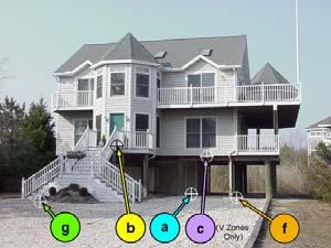
27 Building Diagrams- Section A7 Three basic types of construction Slab on grade or stemwall Basement Elevated (with or without enclosure) 53 Building Diagram 1A All slab-on-grade single- and multiplefloor buildings (other than split-level) and high-rise buildings, either detached or row type with or without attached garage. SLAB ON GRADE BUILDING WITH GARAGE 54 27


28 Building Diagram 1B SLAB ON STEM WALL FOUNDATION All raised-slab-on-grade or slab-onstem-wall-with-fill single- and multiplefloor buildings (other than split-level), either detached or row type with or without attached garage. 55 Building Diagram 2A All single- and multiple-floor buildings with basement (other than split-level) and highrise buildings with basement, either detached or row type; with or without attached garage. TWO-STORY BUILDING WITH BASEMENT, WITHOUT ATTACHED GARAGE 56 28
 and")


;")
29 Building Diagram 2B Single- and multiple-floor buildings with basement (other than split-level) and high-rise buildings with basement, either detached or row type (e.g., townhouses); with or without attached garage 57 Building Diagram 3 SLAB-ON-GRADE, SPLIT-LEVEL BUILDING WITHOUT ATTACHED GARAGE All split-level buildings that are slab-on-grade, either detached or row type (e.g., townhouses); with or without attached garage


30 Building Diagram 4 All split-level buildings (other than slab-on-grade), either detached or row type (e.g., townhouses); with or without attached garage. SPLIT-LEVEL BUILDING WITHOUT ATTACHED GARAGE 59 Elevated Structures Can exist with or without enclosures Breakaways Walls image:


31 Requirements for Enclosures Spaces below elevated buildings can be used only for building access, parking, and limited storage. Enclosures must remain unfinished No mechanical, electrical, or plumbing equipment is to be installed below the BFE. V Zones must have breakaway walls A Zones must be built with flood-resistant materials and have adequate openings 61 Building Diagram 5 MANUFACTURED HOME ELEVATED ON PIER FOUNDATION All buildings elevated on piers, posts, piles, columns, or parallel shear walls. No obstructions below the elevated floor


32 Building Diagram 6 All buildings elevated on piers, posts, piles, columns, or parallel shear walls with full or partial enclosure below the elevated floor. MULTI-LEVEL BUILDING ELEVATED WITH PARTIAL ENCLOSURE 63 Building Diagram 7 BUILDING ELEVATED ON FULL-STORY FOUNDATION WALLS WITH A FULLY ENCLOSED AREA BELOW THE ELEVATED FLOOR. All buildings elevated on full-story foundation walls with a partially or fully enclosed area below the elevated floor. This includes walkout levels, where at least one side is at or above grade. THIS IS AN EXAMPLE OF A WALKOUT AND IS NOT A BASEMENT


 elevated on a sub-grade")
33 Building Diagram 8 All buildings elevated on a crawlspace with the floor of the crawlspace at or above grade on at least one side, with or without an attached garage. ONE-STORY BUILDING ON CRAWL SPACE WITH ATTACHED GARAGE 65 Building Diagram 9 MULTI-LEVEL BUILDING ELEVATED ON A SUB-GRADE CRAWL SPACE All buildings (other than split-level) elevated on a sub-grade crawlspace, with or without attached garage
.")


34 Lowest Floor A Zone Lowest Floor Lowest floor of the lowest enclosed area (including Top basement). of bottom An unfinished floor at or or above flood resistant BFE enclosure, usable solely for parking of vehicles, building access or storage in an area other than a basement area is not considered a building's lowest floor 67 Section A Property Information 68 34
35 Flood Openings A8 and A9 Definition a permanent opening that allows for the free passage of water automatically in both directions without human intervention. Structure is compliant if A8c is equal to or greater than A8a Structure is compliant if A9c is equal to or greater than A9a 69 Enclosures Section A8 and A9 An enclosure is formed when any space below the BFE is enclosed on all sides. Spaces below elevated buildings can be used only for building access, parking, and limited storage. Enclosures must remain unfinished No mechanical, electrical, or plumbing equipment is to be installed below the BFE


36 Section B Flood Map Information FIRM panel information recorded in this section: 71 Key Takeaways Sections A and B Make sure the Building Diagram makes sense. If there is an enclosed area or garage floor below the BFE, compare square footage of crawlspace to net area of openings. If there is an engineered openings, make sure the specification sheet is included with the permit file. Make sure the correct FIRM panel has been used, with consideration to any LOMRs. Check the BFE to make sure that it makes sense and that the flood profile has been used to determine the BFE for streams. A whole number BFE should be a red flag in riverine situations


37 Section C Surveyed Building Elevations Official Survey Required 73 Section C1 Stage of Construction Building Plan Image Source - Under Construction Image Source


38 Section C2 Benchmark and Datum Benchmark image: 41f6-8c b8bedf8.jpg 75 VERTCON image: Section C Building Elevations C.2 Items a-h 76 38


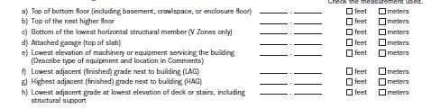
39 Section C Top of Bottom Floor Areas used for C.2.a 77 Section C Top Next Higher Floor Areas used for C.2.b Floor above basement Floor above enclosure Floor above crawl space 78 39


40 Section C Lowest Horizontal Member 79 Section C Attached Garage 80 40

41 Section C Machinery or Equipment Includes elevators, furnaces, hot water heaters, heat pumps, air conditioners, etc. Use comments section to state type of machinery and location 81 Section C Adjacent Grade Elevations C.2.f-h Lowest and highest adjacent grade 82 41


42 Section D Professional Certification Bottom of Page One Official Certification Required Minimum information required: Name License number Signature Date Seal 83 Section D Certifier s Comments Top of Page Two Comments will be included here to clarify any of the entries in Sections A, B, or C

43 Key Takeaways Sections C and D Notice whether building elevations make sense in relation to each other Lowest adjacent grade should not be higher than highest adjacent grade Remember elevations tied to NFIP compliance Top of Bottom Floor Lowest Horizontal Structural Member Lowest Machinery Review certification for legitimacy Review comments for additional important details about the building 85 Section E - Zones A and AO Property owners can provide measurements that insurance agents can use to rate a flood insurance policy in Zone A These elevations are not informative of risk or water surface elevations should not be used for permitting purposes 86 43

44 Section E Zones A and AO For Zones Without Base Flood Elevation This section can provide additional information to rate a flood insurance policy when a BFE is not available 87 Section F Property Owner Certification If a property owner or authorized representative completes Section E, he/she will need to sign and date this section

45 Section G Community Information Only used if a community official completes Sections C or E 89 Additional Considerations No section should be left blank Use N/A or 0 instead of leaving a section blank. Ensure each page of the EC includes the address of the structure The local official should not mark up the form to correct information The information in sections A, B and C is certified by a land surveyor, engineer, or architect who is authorized by law to certify elevation information


46 Completed Elevation Certificate for example Section A 91 Completed Elevation Certificate for example Section B 92 46


47 Elevation Certificate Survey Field Data Plot 1. From survey, plot building, showing spot elevations. 2. Calculate Lowest floor Elevation, LAG and HAG. 3. Indicate locations of any other elevations reported in Section C2. 4. Indicate Building Diagram number. 5. Show photograph locations. BFE = Completed Elevation Certificate for example Section C 94 47


48 Completed Elevation Certificate for example Section D 95 Completed Elevation Certificate for example Section E For Zone A Streams 96 48


49 Completed Elevation Certificate for example Section F For Property Owner Certification only 97 Completed Elevation Certificate for example Section G If prepared by Community Official only 98 49


50 Completed Elevation Certificate for example Building photographs If possible, photo front, rear, left right, stairs and equipment 99 Completed Elevation Certificate for example Building photographs If possible, photo front, rear, left right, stairs and equipment

51 Mapping and Risk Identification LOMCS LETTER OF MAP CHANGE Presenter s Name June 17, Other Mechanisms to Update FIRMs Letters of Map Change (LOMCs) To remove the mandatory flood insurance requirement Inadvertent inclusions structures built on naturally high grade above the SFHA Structures elevated on fill *Caution: Placement of fill around an existing foundation to increase the LAG could result in non-compliance To update the map due to: Better topographic data A physical change in the floodplain Better modeling
 Adjust/refine flood insurance rate information Better understand the flood risk")
52 Why Apply for a LOMC? Most Common Reasons: Remove the mandatory flood insurance requirement (the lender has the option to require insurance) Adjust/refine flood insurance rate information Better understand the flood risk associated with a structure or property Other Reasons: To support a floodplain development permit application To understand the effects of proposed development in the SFHA To reflect the effects of recent development in the floodplain Watercourse alterations/repairs Bridge/culvert/roadway repairs 103 Letters of Map Amendment (LOMAs) LOMAs provide flood zone determinations for individual properties and structures Usually used to show structure is out of the SFHA Not required by floodplain management regulations Based on natural ground elevations No physical change to the FIRM
53 Letters of Map Revision (LOMRs) LOMRs physically update or refine the flood hazard information on the FIRM Results in adjustments to the height of the BFE or boundaries of the SFHA Ensures that the FIRM is the most accurate reflection of the flood risk Requires engineering analyses and scientific data 105 Resources FEMA Map Information exchange (FMIX) Toll free by phone at By at FEMA Map Service Center National Flood Hazard Layer FEMA GeoPortal eloma (Mapping Information Platform) Online LOMC Code of Federal Regulations LOMC Fee Information FEMA Forms NFIP Technical Bulletins USGS Vertical Datum Conversion Information
54 Availability of Flood Insurance Any structure owner in an NFIP participating community can purchase flood insurance. YES, this means any structure and its contents inside or outside of the Special Flood Hazard Area can be covered! Flood insurance may be sold by any state-licensed insurance agent. 107 Flood Insurance FloodSmart.gov Need help finding an insurance agent call or go to

55 Mandatory Purchase Requirement Mandatory purchase of flood insurance for structures in or touching the SFHA Caveat although insurance may not be required, lenders have the prerogative to require insurance to cover perceived risk Not Required Required 109 Rating Considerations Elevation in relation to BFE / LAG Flood Zone Compliant Openings Pre/Post-FIRM Mechanicals elevation Residential vs. non-residential Floodproofing Elevation Certificates
56 Preferred Risk Policy (PRP) Any insurable structure located in B, C or X Zones that have not experienced significant previous flood damage. Provides combinations of building and contents coverage Reasonably priced starts around $125 a year depending on amount of coverage. Thirty percent of all flood damage claims nationwide are from structures located outside the floodplain. 111 Impact of changes to the NFIP resulting from BW 2012 and HFIAA 2014 CHANGES TO THE NFIP
57 Changes are Coming to the NFIP Flood Insurance Reform Act of 2012 (Biggert Waters 2012) Homeowner Flood Insurance Affordability Act of 2014 Goal: To make the NFIP more financially stable by raising rates on certain classes of property to reflect true flood risk Mechanism: Premium rate changes for some subsidized policies to accurately reflect the flood risk. Addition of annual policy surcharges 113 Flood Risks and Costs are Changing Insurance Reform Messaging Why are Rates Increasing? Weather patterns, erosion, and development are a few factors increasing flood risk in many communities. Better science, improved tools and more data are providing more accurate definition of flood hazards. More buildings and other infrastructure are being built in areas at risk for flooding and replacement costs continue to grow
58 Flood Insurance Rates are Changing Rates for most properties will more accurately reflect risk. Subsidized rates are being phased out over the next several years. Premium rates for most categories will increase between 5 15 percent annually. Surcharges are not considered premium and will be in addition to annual premium increases. 115 Who Will Be Affected? Only 20% of NFIP policies receive subsidies Gradual rate increases of 5%-15% annually Premiums cannot increase more than 18% annually Exceptions for policies that will see 25% annual until reaching full-risk rates: Older business properties insured with subsidized rates Older non-primary residences insured with subsidized rates Severe Repetitive Loss Properties insured with subsidized rates Buildings that have been substantially damaged or improved New purchaser can retain the same rates as the prior owner
59 Grandfathering Under HFIAA When maps change properties can be grandfathered into lower risk classes/lower BFE Newly identified properties in the SFHA may be eligible for reduced premiums under the Newly Mapped Procedure No more than an 18% premium increase annually for an individual policyholder 117 Elevating Above the BFE Saves Money NFIP premiums based on October 2011 rates One-floor residential structure with no basement built Post-FIRM $250,000 coverage for the building and $100,000 for contents At BFE Insurance Premium: $1,315 building, $380 contents Zone AE Annual NFIP Insurance Savings Savings Over 30 Year Mortgage 1 ft. below BFE -$3,415 -$102,450 At BFE ft. freeboard $675 (49%) $20,250 2 ft. freeboard $911 (69%) $27,330 3 ft. freeboard $983 (75%) $29,
60 Summary: What We Covered a broad overview of the components of the NFIP mapping tools and resources Elevation Certificate considerations flood insurance implications updates on changes to the NFIP and insurance reform 119 Questions?
National Flood Insurance Program (NFIP) for Real Estate Professionals
 for Real Estate Professionals") National Flood Insurance Program (NFIP) for Real Estate Professionals 1 Joshua Oyer, CFM Outreach Specialist NFIP State Coordinator s Office at the Texas Water Development Board 2 Outline Introduction
National Flood Insurance Program (NFIP) for Real Estate Professionals 1 Joshua Oyer, CFM Outreach Specialist NFIP State Coordinator s Office at the Texas Water Development Board 2 Outline Introduction
FEMA Elevation Certificates and Hydrostatic Venting Requirements
 FEMA Elevation Certificates and Hydrostatic Venting Requirements Tennessee Association of Floodplain Managers Conference Gatlinburg, TN July 30 August 2, 2013 1 What is the National Flood Insurance Program
MOKAN CRS Users Group Activity 310, Elevation Certificates Packet
 http://mokan.stormsmart.org/ MOKAN CRS Users Group Activity 310, Elevation Certificates Packet This packet includes the following documents to be used as applicable to your community: EC checklist EC correction
NFIP Mapping Issues. Wendy Lathrop, PLS, CFM. Cadastral Consulting, LLC
 NFIP Mapping Issues Cadastral Consulting, LLC NFIP Basic Objectives: Reduce the exposure to flood damages through the use of minimum standards for the placement and design of structures located in flood
Abington Township Public Meeting
 Abington Township Public Meeting Flood Insurance Rate Map Update March 23, 2016 1 Meeting Agenda and Format Provide residents/property owners of Abington Township with information about the map update,
NFIP Overview Elevation Certificate Flood Insurance Rate Maps. By: Maureen O Shea, AICP, CFM State NFIP Coordinator
 NFIP Overview Elevation Certificate Flood Insurance Rate Maps By: Maureen O Shea, AICP, CFM State NFIP Coordinator Example of a flood failure Example of a flood failure Purposes of the NFIP Identify &
Durham County Preliminary Flood Hazard Data Public Meeting. July 28, 2016
 Durham County Preliminary Flood Hazard Data Public Meeting July 28, 2016 Why Are We Here New flood hazard data has been released as Preliminary for Durham County Statutory Due Process for review/comments
SPECIAL CERTIFICATIONS
 SPECIAL CERTIFICATIONS This section presents detailed instructions for the completion of the National Flood Insurance Program (NFIP) Elevation Certificate (EC) and the NFIP Floodproofing Certificates.
Kevin Wagner Maryland Department of the Environment
 Kevin Wagner Maryland Department of the Environment Topics Overview of the National Flood Insurance Program (NFIP) Mapping Regulations Insurance Mitigation Community Rating System (CRS) Questions Know
Floodplain Management 101: UNIT II. Maps & Flood Insurance Studies
 Floodplain Management 101: UNIT II Maps & Flood Insurance Studies Who is ASFPM? ASFPM stands for the Association of State Floodplain Managers A national organization of floodplain management professionals
THE FEDERAL EMERGENCY MANAGEMENT AGENCY. Letters of Map Change Kristen Martinenza, P.E., CFM FEMA Region IV
 THE FEDERAL EMERGENCY MANAGEMENT AGENCY Letters of Map Change Presented by: Kristen Martinenza, P.E., CFM FEMA Region IV 1 NATIONAL FLOOD INSURANCE ACT OF 1968 At the start of the program, there was not
FREQUENTLY ASKED QUESTION ABOUT FLOODPLAINS Michigan Department of Environmental Quality
 FREQUENTLY ASKED QUESTION ABOUT FLOODPLAINS Michigan Department of Environmental Quality WHAT IS A FLOOD? The National Flood Insurance Program defines a flood as a general and temporary condition of partial
ATTACHMENT A SUMMARY OF THE NFIP OCTOBER 2013 PREMIUM RATE AND RULE CHANGES
 ATTACHMENT A SUMMARY OF THE NFIP OCTOBER 2013 PREMIUM RATE AND RULE CHANGES National Flood Insurance Program October 1, 2013, Premium Rate and Rule Changes: A Summary 1. Premium Increases Premiums will
National Flood Insurance Program, Biggert-Waters 2012, and Homeowners Flood Insurance Affordability Act 2014
 National Flood Insurance Program, Biggert-Waters 2012, and Homeowners Flood Insurance Affordability Act 2014 Janice Mitchell, Insurance Specialist Floodplain Management and Insurance Branch FEMA Region
Flood Insurance for Local Officials and Floodplain Managers. What Every Community Official Needs to Know About Flood Insurance
 Flood Insurance for Local Officials and Floodplain Managers What Every Community Official Needs to Know About Flood Insurance Illinois Association for Floodplain and Stormwater Management 2011 Annual Conference
May 1, Write Your Own (WYO) Principal Coordinators and the National Flood Insurance Program (NFIP) Servicing Agent
 Principal Coordinators and the National Flood Insurance Program (NFIP) Servicing Agent") U.S. Department of Homeland Security 500 C St. SW Washington, D.C. 20472 W-15016 May 1, 2015 MEMORANDUM FOR: Write Your Own (WYO) Principal Coordinators and the National Flood Insurance Program (NFIP)
U.S. Department of Homeland Security 500 C St. SW Washington, D.C. 20472 W-15016 May 1, 2015 MEMORANDUM FOR: Write Your Own (WYO) Principal Coordinators and the National Flood Insurance Program (NFIP)
Mistakes on Elevation Certificates
 Mistakes on Elevation Certificates What is the Base Flood Elevation (BFE) & how do you determine it? FIRM Map Panel? Flood Insurance Study? o Profile Sheet o Floodway Data Chart o Stillwater Chart Community
W October 1, Write Your Own (WYO) Principal Coordinators and the National Flood Insurance Program (NFIP) Servicing Agent
 Principal Coordinators and the National Flood Insurance Program (NFIP) Servicing Agent") U.S. Department of Homeland Security 500 C St. SW Washington, D.C. 20472 W-14053 October 1, 2014 MEMORANDUM FOR: Write Your Own (WYO) Principal Coordinators and the National Flood Insurance Program (NFIP)
U.S. Department of Homeland Security 500 C St. SW Washington, D.C. 20472 W-14053 October 1, 2014 MEMORANDUM FOR: Write Your Own (WYO) Principal Coordinators and the National Flood Insurance Program (NFIP)
Updates to Maine Coastal Flood Insurance Rate Maps (FIRM s): What a Local Official Should Know. Presented by: Steve Johnson, P.E.
: What a Local Official Should Know. Presented by: Steve Johnson, P.E.") Updates to Maine Coastal Flood Insurance Rate Maps (FIRM s): What a Local Official Should Know Presented by: Steve Johnson, P.E. Town Engineer October 4, 2018 Introduction Federal Emergency Management
Updates to Maine Coastal Flood Insurance Rate Maps (FIRM s): What a Local Official Should Know Presented by: Steve Johnson, P.E. Town Engineer October 4, 2018 Introduction Federal Emergency Management
Pinellas County Flood Map Information Service & Real Estate Disclosure Program Training January 26, 2017 COMMON FLOODPLAIN ACRONYMS
 FEMA ASFPM BFE CAV Pinellas County Flood Map Information Service & Real Estate Disclosure Program Training COMMON FLOODPLAIN ACRONYMS Federal Emergency Management Agency Association of State Floodplain
Zone A. Non Studied Area? Where do we go? Establishing the BFE. Bridge Design 1/9/2019
 Karol L. Grove Licensed Professional Surveyor Certified Floodplain Manager 1 Establishing the BFE Zone A Where do we go? Non Studied Area? 2 Bridge Design 3 1 4 5 6 2 Look at the age of the culvert or
JAXGIS FEMA Flood Hazard Mapping -- Frequently Asked Questions
 Flood Hazard Zone Designations Summary Zones starting with the letter 'A' (for instance, Zone A, Zone AE, Zone AH, Zone AO) denote a Special Flood Hazard Area, which can also be thought of as the 100-year
Door County Floodplain Program Informational Meeting
 Door County Floodplain Program Informational Meeting Door County Land Use Services Department Wisconsin Department of Natural Resources January 15, 2018 Floodplain = Land affected by flood event with a
Federal Emergency Management Agency
 Page 1 of 5 Issue Date: July 27, 2012 Effective Date: December 10, 2012 Case No.: 11-06-4512P Follows Conditional Case No.: 06-06-B789R LOMR-APP Federal Emergency Management Agency Washington, D.C. 20472
Oak Island 1999 Hurricane Floyd
 Oak Island 1999 Hurricane Floyd Topics to be Discussed What is a flood zone Flood zones in Oak Island Special Flood Hazard Areas (SFHA) Flood insurance Base Flood Elevations (BFEs) Building in flood zones
National Flood Insurance Program and Biggert-Waters 2012
 National Flood Insurance Program and Biggert-Waters 2012 National Flood Insurance Program NFIP was created by Congress in 1968 Coverage underwritten by the Federal Government, administered by FEMA NFIP
Floodplain Management 101. Mississippi Emergency Management Agency Floodplain Management Bureau
 Floodplain Management 101 Mississippi Emergency Management Agency Floodplain Management Bureau Stafford Act The Stafford Disaster Relief and Emergency Assistance Act (Stafford Act) (Public Law 100-707)
a) Ensure public safety through reducing the threats to life and personal injury.
 Ensure public safety through reducing the threats to life and personal injury.") SECTION VII: FLOODPLAIN DISTRICT 7-1 Statement Of Purpose The purposes of the Floodplain District are to: a) Ensure public safety through reducing the threats to life and personal injury. b) Eliminate
SECTION VII: FLOODPLAIN DISTRICT 7-1 Statement Of Purpose The purposes of the Floodplain District are to: a) Ensure public safety through reducing the threats to life and personal injury. b) Eliminate
Agenda. Introduction. Introduction -Map Study Lifecycle. Insurance Benefits of New Map
 Agenda Introduction Effects of Map Changes on Flood Insurance Lower risk to higher risk ( Grandfathering ) Higher risk to lower risk ( Conversion ) No Change Vertical Datum change Summary Levees Levees
Federal Emergency Management Agency
 Page 1 of 4 Issue Date: October 2, 2017 Effective Date: October 2, 2017 Case No.: 17-09-2731P LOMR-APP Federal Emergency Management Agency Washington, D.C. 20472 LETTER OF MAP REVISION DETERMINATION DOCUMENT
11/18/2011. FEMA All rights reserved. FEMA All rights reserved. Session Overview
 3 Session Overview 4 1 Welcome to Session 2 of the FEMA NFIP Agent Training Program! Dorothy Martinez Rich Slevin Recall your learning from the previous session and share at least one important takeaway.
Revisions to National Flood Insurance Program Maps
 MT-1 Revisions to National Flood Insurance Program Maps Application Forms and Instructions for Conditional and Final Letters of Map Amendment and Letters of Map Revision Based on Fill FEMA Form 81-87 Series
Now forget it all for the next 90 minutes.
 Karol L. Grove, PS Get ready to think outside of the box. Get ready to think about surveying, flood zones and flood insurance in a whole new light.. Think about everything you think you know about Elevation
Article 23-6 FLOODPLAIN DISTRICT
 AMENDING THE CODE OF THE CITY OF PITTSFIELD CHAPTER 23, ZONING ORDINANCE SECTION I That the Code of the City of Pittsfield, Chapter 23, Article 23-6 Floodplain District, shall be replaced with the following:
Floodplain Development Permit Application
 Floodplain Development Permit Application City of Jonesboro, AR This is an application packet for a Floodplain Development Permit. Certain sections are to be completed by the Applicant, and certain sections
Enough about me! Topics Covered
 About Me Worked in land surveying since 1997 Employed by the City of Orlando since 2006 City of Orlando City Surveyor since February 2015 Certified Floodplain Manager since 2015 Florida Licensed Surveyor,
What Was Updated in 2004 in Hennepin Countywide Maps?
 What Was Updated in 2004 in Hennepin Countywide Maps? Combined the city and township maps into one countywide index Done by USACE Mainly digital capture of old floodplain boundaries; some spots with shifts
Floodplain Development Permit Application
 Floodplain Development Permit Application **All construction will also require a building permit** This is an application packet for a Floodplain Development Permit. Certain sections are to be completed
PREFERRED RISK POLICY
 Previous Section Main Menu Table of Contents Next Section PREFERRED RISK POLICY I. GENERAL DESCRIPTION The Preferred Risk Policy (PRP) is a lower-cost Standard Fld Insurance Policy (SFIP), written under
Maryland Model Floodplain Management Ordinance (May, 2014) MODEL NOTES
 MODEL NOTES") Maryland Model Floodplain Management Ordinance (May, 2014) MODEL NOTES The model floodplain management ordinance that most Maryland communities have used as the basis for their regulations since the early
Maryland Model Floodplain Management Ordinance (May, 2014) MODEL NOTES The model floodplain management ordinance that most Maryland communities have used as the basis for their regulations since the early
Federal Emergency Management Agency
 Page 1 of 6 Issue Date: May 13 2016 Case No.: Follows Conditional Case No.: 14-05-0595R DETERMINATION DOCUMENT COMMUNITY AND REVISION INFORMATION PROECT DESCRIPTION BASIS OF REQUEST COMMUNITY Village of
Federal Emergency Management Agency
 Page 1 of 4 Issue Date: September 7, 2012 Effective Date: January 22, 2013 DETERMINATION DOCUMENT COMMUNITY COMMUNITY AND REVISION INFORMATION City of Lubbock Lubbock County Texas PROJECT DESCRIPTION CHANNELIZATION
Introduction to the National Flood Insurance Program: A Guide for Coastal Property Owners MAINE BEACHES CONFERENCE 2017
 Introduction to the National Flood Insurance Program: A Guide for Coastal Property Owners MAINE BEACHES CONFERENCE 2017 SUE BAKER, CFM STATE NFIP COORDINATOR MAINE DEPT OF AGRICULTURE, CONSERVATION & FORESTRY
Changes Coming to the National Flood Insurance Program What to Expect. Impact of changes to the NFIP under Section 205 of the Biggert-Waters Act
 Changes Coming to the National Flood Insurance Program What to Expect Impact of changes to the NFIP under Section 205 of the Biggert-Waters Act Flood Risk Flood risks and the costs of flooding Weather
Federal Emergency Management Agency
 Page 1 of 5 Issue Date: June 21, 2013 Follows Conditional Case No.: 04-06-A148R DETERMINATION DOCUMENT COMMUNITY COMMUNITY AND REVISION INFORMATION City of Irving Dallas County Texas FILL PROJECT DESCRIPTION
Florida Division of Emergency Management
 2017 FLOODPLAIN MANAGEMENT IN FLORIDA Florida Division of Emergency Management Bureau of Mitigation State Floodplain Management Office 2555 Shumard Oak Boulevard, Tallahassee, FL 32399 www.floridadisaster.org/mitigation
Federal Emergency Management Agency
 Page 1 of 6 Issue Date: September 27, 2010 Effective Date: February 14, 2011 Follows Conditional Case No.: 08-08-0873R DETERMINATION DOCUMENT COMMUNITY AND REVISION INFORMATION PROJECT DESCRIPTION BASIS
A Continuing Education Correspondence Course for Land Surveyors, Engineers, and Floodplain Managers
 By: David Melvin, PLS, CFM Land Pro Seminars A Continuing Education Correspondence Course for Land Surveyors, Engineers, and Floodplain Managers (Examination materials, questions, and answer sheet are
Appendix D - Floodplain Documents
 City of Aspen Urban Runoff Management Plan Appendix D - Floodplain Documents 1. Floodplain Development Permit 2. Elevation Certificate and Instructions 3. Floodproofing Certificate for Non-Residential
April 2, Write Your Own Principal Coordinators and the NFIP Servicing Agent
 U.S. Department of Homeland Security 500 C Street, SW Washington, DC 20472 W-09021 April 2, 2009 MEMORANDUM TO: Write Your Own Principal Coordinators and the NFIP Servicing Agent FROM: SUBJECT: Edward
Federal Emergency Management Agency
 Page 1 of 5 Issue Date: October 16, 2014 Effective Date: March 2, 2015 Case No.: 14-09-2279P LOMR-APP Federal Emergency Management Agency Washington, D.C. 20472 LETTER OF MAP REVISION DETERMINATION DOCUMENT
Requirements for Construction on Properties in the Special Flood Hazard Area (SFHA)
") Requirements for Construction on Properties in the Special Flood Hazard Area (SFHA) Rev 010915 The website for the IDNR to request the EFARA (Electronic Floodplain Analysis/Regulatory Assessment is found
Requirements for Construction on Properties in the Special Flood Hazard Area (SFHA) Rev 010915 The website for the IDNR to request the EFARA (Electronic Floodplain Analysis/Regulatory Assessment is found
Chapter 6 - Floodplains
 Chapter 6 - Floodplains 6.1 Overview The goal of floodplain management is to reduce the potential risks to both existing and future developments, and infrastructure, in the 100-year floodplain. Over the
FLOODPLAIN FAQ s. Last Update: June 2017
 FLOODPLAIN FAQ s Last Update: June 2017 What does FEMA stand for? Federal Emergency Management Agency - the operation of FEMA is to lead America to prepare for, prevent, respond to, and recover from disasters.
Federal Emergency Management Agency
 Page 1 of 4 Issue Date: April 26, 2013 DETERMINATION DOCUMENT COMMUNITY AND REVISION INFORMATION PROJECT DESCRIPTION BASIS OF REQUEST City of Coppell Dallas County Texas FILL HYDRAULIC ANALYSIS NEW TOPOGRAPHIC
NFIP Program Basics. KAMM Regional Training
 NFIP Program Basics KAMM Regional Training Floodplain 101 Homeowners insurance does not cover flood damage Approximately 25,000 flood insurance policies in KY According to BW12 analysis, approximately
Federal Emergency Management Agency
 Page 1 of 4 Issue Date: August 1, 2012 Effective Date: December 13, 2012 Case No.: 12-06-0595P LOMR-APP Washington, D.C. 20472 LETTER OF MAP REVISION DETERMINATION DOCUMENT COMMUNITY AND REVISION INFORMATION
Using GISWeb to Determine Your Property s Flood Zone
 Using GISWeb to Determine Your Property s Flood Zone 1. In a new browser window, go to http://www.co.santacruz.ca.us/departments/geographicinformationsystemsgis.aspx 2. Click on GISWeb - GIS Mapping Application
17.13 FLOOD DAMAGE PREVENTION ORDINANCE. Article I. Statutory Authorization, Findings of Fact, Purpose, and Methods
 17.13 FLOOD DAMAGE PREVENTION ORDINANCE Article I Statutory Authorization, Findings of Fact, Purpose, and Methods 17.1301 Statutory Authorization. The Legislature of the State of South Dakota has in (statutes)
Herkimer County, New York Flood Hazard Mapping Status Report for Property Owners
 Herkimer County, New York Flood Hazard Mapping Status Report for Property Owners Herkimer County, New York Flood Hazard Mapping Status Report for Property Owners FLOOD INSURANCE Who Should Purchase Flood
Role of the Local Floodplain Administrator
 2/22/2016 Role of the Local Floodplain Administrator Marsha Hilmes-Robinson Floodplain Administrator City of Fort Collins, Colorado mhilmesrobinson@fcgov.com 1 Partnership Engineer/Architect/ Contractor
Federal Emergency Management Agency
 Page 1 of 6 Issue Date: October 24, 2012 Effective Date: March 7, 2013 Case No.: LOMR-APP DETERMINATION DOCUMENT COMMUNITY AND REVISION INFORMATION PROJECT DESCRIPTION BASIS OF REQUEST City of Lubbock
Table 1: Federal, State and Local Government Rules applicable to LOMRs/CLOMRS submittal
 MnDNR LOMC Guide This document has been prepared by the Minnesota Department of Natural Resources floodplain staff and is intended to provide assistance with LOMR/CLOMR submittals. This information is
REGION X FLOOD DAMAGE PREVENTION ORDINANCE WASHINGTON MODEL (REVISED 5/13/2004)
") REGION X FLOOD DAMAGE PREVENTION ORDINANCE WASHINGTON MODEL (REVISED 5/13/2004) Close to 300 towns, cities, counties, and tribes within the State of Washington participate in the National Flood Insurance
REGION X FLOOD DAMAGE PREVENTION ORDINANCE WASHINGTON MODEL (REVISED 5/13/2004) Close to 300 towns, cities, counties, and tribes within the State of Washington participate in the National Flood Insurance
ORDINANCE NO. 246 FLOOD DAMAGE PREVENTION ORDINANCE STATUTORY AUTHORIZATION, FINDINGS OF FACT, PURPOSE, AND OBJECTIVES
 ORDINANCE NO. 246 FLOOD DAMAGE PREVENTION ORDINANCE Article I. Section A. STATUTORY AUTHORIZATION, FINDINGS OF FACT, PURPOSE, AND OBJECTIVES Statutory Authority The Legislature of the State of Idaho, pursuant
Michigan Department of Environmental Quality 525 West Allegan Street Lansing, MI (517)
") FLOODPLAIN MANAGEMENT IN MICHIGAN 2002 John Engler, Governor Russell J. Harding, Director Michigan Department of Environmental Quality 525 West Allegan Street Lansing, MI 48909 (517) 373-1170 www.michigan.gov/deq
FLOODPLAIN MANAGEMENT IN MICHIGAN 2002 John Engler, Governor Russell J. Harding, Director Michigan Department of Environmental Quality 525 West Allegan Street Lansing, MI 48909 (517) 373-1170 www.michigan.gov/deq
AMENDMENTS TO CHAPTER 50: FLOODPLAIN DEVELOPMENT
 AMENDMENTS TO CHAPTER 50: FLOODPLAIN DEVELOPMENT PART I: 2018 FLOOD MAP IMPLEMENTATION PART II: STRATEGIES TO IMPROVE THE CITY S COMMUNITY RATING SYSTEM SCORE NATIONAL FLOOD INSURANCE PROGRAM (NFIP) CREATED
History of Floodplain Management in Ascension Parish
 History of Floodplain Management in Ascension Parish presented by: Kara Moree Floodplain Coordinator February 6, 2012 Floodplain 101 Floodplain 101 Base or 1% Flood: A flood having a 1% chance of being
October 1, Write Your Own (WYO) Principal Coordinators and the National Flood Insurance Program (NFIP) Servicing Agent
 Principal Coordinators and the National Flood Insurance Program (NFIP) Servicing Agent") U.S. Department of Homeland Security Washington, D.C. 20472 October 1, 2015 MEMORANDUM FOR: Write Your Own (WYO) Principal Coordinators and the National Flood Insurance Program (NFIP) Servicing Agent FROM:
U.S. Department of Homeland Security Washington, D.C. 20472 October 1, 2015 MEMORANDUM FOR: Write Your Own (WYO) Principal Coordinators and the National Flood Insurance Program (NFIP) Servicing Agent FROM:
Federal Emergency Management Agency
 Page 1 of 5 Issue Date: April 2, 2015 DETERMINATION DOCUMENT COMMUNITY AND REVISION INFORMATION PROJECT DESCRIPTION BASIS OF REQUEST Ventura County California NO PROJECT UPDATE COMMUNITY (Unincorporated
Skagit County Flood Insurance Study Update. Ryan Ike, CFM FEMA Region 10
 Skagit County Flood Insurance Study Update Ryan Ike, CFM FEMA Region 10 Skagit County Flood Insurance Study Process Overview Process, Schedule, & Deliverables Base Flood Elevations, Modeling, & Levees
BEING PREPARED FOR MAP CHANGES What to Know; What to Say National Flood Conference May 16, 2016
 BEING PREPARED FOR MAP CHANGES What to Know; What to Say National Flood Conference May 16, 2016 0 Discussion Topics Risk MAP Program Background Eric Simmons FEMA Region 9 Map Change Rating Options Edie
SECTION 9: MAPS AND DATA
 SECTION 9: MAPS AND DATA Contents 9.1. NFIP Maps and Data... 9-2 9.1.1. Adopting and enforcing NFIP floodplain maps and data... 9-2 9.1.2. Adopting and enforcing more restrictive data... 9-2 9.1.3. Annexations...
Frequently Asked Questions and Answers Concerning Flood Insurance
 Frequently Asked Questions and Answers Concerning Flood Insurance Sources Used: (1) www.floodsmart.gov (2) National Flood Insurance Program, Answers to Questions about the NFIP, FEMA F-084/ March 2011.
FLOOD INSURANCE. Introduction
 FLOOD INSURANCE Introduction The purpose of this course is to provide a comprehensive description of the NFIP for insurance producers who are seeking continuing education credits. It provides an overview
TOWN OF KENT, CT PLANNING AND ZONING COMMISSION
 TOWN OF KENT, CT PLANNING AND ZONING COMMISSION FLOOD PLAIN MANAGEMENT REGULATIONS Whereas, Congress has determined that a National Flood Insurance Program would alleviate personal hardships and economic
CONTRA COSTA COUNTY FLOODPLAIN MANAGEMENT PROGRAM
 CONTRA COSTA COUNTY FLOODPLAIN MANAGEMENT PROGRAM Answers to Commonly Asked Questions and A Guide for Residential Construction Within Special Flood Hazard Areas Revised February 2015 Introduction Ninety
NFIP: October 2016 Updates and Community Decision Impacts on Individual Rates
 NFIP: October 2016 Updates and Community Decision Impacts on Individual Rates Carl Watts, Regional Liaison NFIP-iService, Region VI cwatts@nfip-iservice.com P: 405-257-9000 1 1 NFIP: Review and October
Indiana Department of Natural Resources Division of Water
 2018 FLOODPLAIN MANAGEMENT IN INDIANA Indiana Department of Natural Resources Division of Water 402 W. Washington St., Room W264 n Indianapolis, IN 46204 317-232-4160 n in.gov/dnr/water Table of Contents
10526 Bermuda Isle Dr. Tampa, FL 33647
 Flood Analysis Memo Property Address In Partnership with: ** This property is NOT within a high-risk flood zone ** This property is located in a FEMA low-risk zone designated as Zone X - an area of minimal
ADVISORY BASE FLOOD ELEVATIONS (ABFEs)
") The Department of Homeland Security s Federal Emergency Management Agency is committed to helping communities that were impacted by Hurricanes Katrina and Rita rebuild safer and stronger. Following catastrophic
The Department of Homeland Security s Federal Emergency Management Agency is committed to helping communities that were impacted by Hurricanes Katrina and Rita rebuild safer and stronger. Following catastrophic
Gail Moldovan-Trujillo, ACSR,CPIW Hagan Hamilton Insurance 2012 NFIP Agency of the year Flood Insurance Specialist & Consultant
 Gail Moldovan-Trujillo, ACSR,CPIW Hagan Hamilton Insurance 2012 NFIP Agency of the year Flood Insurance Specialist & Consultant Flood Insurance regulations continue to change at a very rapid pace, therefore
Federal Emergency Management Agency
 Page 1 of 3 COMMUNITY AND MAP PANEL INFORMATION COMMUNITY CITY OF MARGATE CITY, ATLANTIC COUNTY, NEW JERSEY LEGAL PROPERTY DESCRIPTION A parcel of land, as described in Deed recorded in Book 4826, page
COLLIER COUNTY FLOODPLAIN MANAGEMENT
 COLLIER COUNTY FLOODPLAIN MANAGEMENT FREQUENTLY ASKED QUESTIONS The following information is based on common questions from the public. If you have a specific question or need further information, please
Kentucky Division of Water Permitting Floodplain Overview and Considerations
 Kentucky Division of Water Permitting Floodplain Overview and Considerations Presentation to: 2014 KAMM Conference Lake Barkley State Resort Park by Solitha Dharman Department for Environmental Protection
FLOOD INSURANCE APPLICATION, PART 1 (OF 2) IMPORTANT PLEASE PRINT OR TYPE; ENTER DATES AS MM/DD/YYYY.
 IMPORTANT PLEASE PRINT OR TYPE; ENTER DATES AS MM/DD/YYYY.") Make checks payable to: Wright National Flood Insurance Company P.O. Box 33003 St. Petersburg, FL 33733-8003 Phone (800) 323-8841 FLOOD INSURANCE APPLICATION, PART 1 (OF 2) IMPORTANT PLEASE PRINT OR TYPE;
Make checks payable to: Wright National Flood Insurance Company P.O. Box 33003 St. Petersburg, FL 33733-8003 Phone (800) 323-8841 FLOOD INSURANCE APPLICATION, PART 1 (OF 2) IMPORTANT PLEASE PRINT OR TYPE;
Floodplain Design, Construction, and Impacts On Flood Insurance
 Floodplain Design, Construction, and Impacts On Flood Insurance AIA/CES Registration Architectural Record is a registered provider with The American Institute of Architects Continuing Education Systems.
North Carolina Department of Public Safety Emergency Management Risk Management
 North Carolina Department of Public Safety Emergency Management Risk Management Roy Cooper, Governor Erik A. Hooks, Secretary Michael A. Sprayberry, Director INSTRUCTIONS FOR COMPLETING THE NORTH CAROLINA
FLOOD DAMAGE PREVENTION RULES
 60.3(d) FLOOD DAMAGE PREVENTION RULES ARTICLE 1 STATUTORY AUTHORIZATION, FINDINGS OF FACT, PURPOSE AND METHODS SECTION A. STATUTORY AUTHORIZATION The Legislature of the State of Texas adopted the Flood
10526 Bermuda Isle Dr. Tampa, FL 33647
 Flood Analysis Memo Property Address 10526 Bermuda Isle Dr. In Partnership with: ** This property is NOT within a high-risk flood zone ** 10526 Bermuda Isle Dr. BFE = 35 ft This property is located in
CRISP COUNTY, GEORGIA AND INCORPORATED AREAS
 CRISP COUNTY, GEORGIA AND INCORPORATED AREAS Community Name Community Number ARABI, CITY OF 130514 CORDELE, CITY OF 130214 CRISP COUNTY (UNINCORPORATED AREAS) 130504 Crisp County EFFECTIVE: SEPTEMBER 25,
Federal Emergency Management Agency
 Page 1 of 4 Issue Date: November 16 2016 Effective Date: March 31 2017 Case No: 16-06-2056P LOMR-APP Follows Conditional Case No: 10-06-3320R Federal Emergency Management Agency Washington DC 20472 LETTER
Pre-Development Floodplain Application
 Pre-Development Floodplain Application The Department of Planning, at the recommendation of FEMA, is now requiring completion of a Pre- Development Floodplain Application for all properties in the regulated
City of St. Augustine. Floodplain Management Higher Standards Information
 City of St. Augustine Floodplain Management Higher Standards Information There are different regulations that communities can use to help protect existing and future development and natural floodplain
Kentucky Floodplain Administrators Handbook
 Kentucky Floodplain Administrators Handbook A Guide for Local Permitting Officials This handbook is published by the Floodplain Management Section of the Department for Environmental Protection, Division
DEC NFIP Regional Coordinators REGIONAL OFFICES. DEC NFIP Regional Coordinators REGIONAL OFFICES 10/26/2016. DEC Floodplain Coordinators
 1 2 Flood Maps, FEMA Elevation Certificates and Letters of Map Change Floodplain Management Section Bureau of Flood Protection and Dam Safety Introduction to the National Flood Insurance Program NYSAPLES
Flooding Part One: BE Informed. Department of Planning & Development
 Flooding Part One: BE Informed Department of Planning & Development Introduction The residents of the City of Noblesville enjoy many benefits from being located on the banks of the White River. These benefits
ORDINANCE NO A FLOOD DAMAGE PREVENTION ORDINANCE
 ORDINANCE NO. 692-14 A FLOOD DAMAGE PREVENTION ORDINANCE WHEREAS, for a community to participate in the National Flood Insurance Program NFIP, it must adopt and enforce floodplain management regulations
YAVAPAI COUNTY FLOOD CONTROL DISTRICT STAKEHOLDER WORKSHOP. March 30 th & 31 st, 2015
 YAVAPAI COUNTY FLOOD CONTROL DISTRICT STAKEHOLDER WORKSHOP March 30 th & 31 st, 2015 1 Floods Happen In Yavapai County September 1983 Northwest Prescott Area: - Willow Creek - Bottleneck Wash - Granite
WHEREAS, the base flood elevation set forth within Ordinance No. 351 was intended in all instances to be 18 inches and not two feet ; and,
 ORDINANCE NO. 353 OF THE CITY OF BUCKHANNON, AN ORDINANCE: (1) ESTABLISHING A FLOODPLAIN AREA AND REQUIRING ALL CONTRACTORS, PERSONS, PARTNERSHIPS, BUSINESSES, AND CORPORATIONS TO OBTAIN A PERMIT FOR THE