Duval County, Florida Consultation Coordination Officer (CCO) Meeting. January 25, 2017 Jacksonville, Florida
|
|
|
- Zoe Jefferson
- 6 years ago
- Views:
Transcription


1 Duval County, Florida Consultation Coordination Officer (CCO) Meeting January 25, 2017 Jacksonville, Florida

2 Agenda Introductions Coastal Study Update Study Process and Timeline Flood Insurance Implications Questions and Answers 2

3 Northeast Florida Coastal Flood Risk Study 3
 Determined from 2. Amount of wave setup storm surge model 3. Wave height above storm surge (SWEL) elevation 4.")
4 Basic Elements of a Coastal Flood Risk Study Base Flood Elevation (BFE) on FIRM includes four components: 1. Storm surge stillwater elevation (SWEL) Determined from 2. Amount of wave setup storm surge model 3. Wave height above storm surge (SWEL) elevation 4. Wave runup above storm surge elevation (where present) 4


5 Basic Elements of a Coastal Flood Risk Study (Cont d) 5
6 LiMWA 6
7 Post-Preliminary Processing Schedule Preliminary Flood Insurance Rate Map (FIRM) Issued CCO Meeting and Public Open House End of Appeal & Comment Period Letter of Final Determination Effective FIRM Preliminary Phase Meetings 90-Day Appeal & Comment Period Resolve Appeals & Finalize Map Products 6-Month Adoption/ Compliance Period 7
8 Duval County Schedule Preliminary FIRM Issued July 29, 2016 CCO Meeting and Public Open House January 24-25, 2017 Appeal/Comment Period March 2017 June 2017* Letter of Final Determination Issued August 2017* Community Adoption/Compliance Period August 2017 February 2018* Effective FIRM February 2018* *estimated times 8
9 Preliminary FIRM Issued July 29, 2016 A Preliminary Map Package was sent to each community that included: FIRM Panels Duval County Index Panel Flood Insurance Study (FIS) Report Summary of Map Actions (SOMA) Digital Data 9


10 Duval County Map Update 10
11 Flood Zone Changes in Duval County Community Name # Buildings: Increase # Buildings: Decrease # Buildings: Net Change Changes to # of Buildings Within SFHA Jacksonville 2,017 1, Jacksonville Beach 1, Atlantic Beach Neptune Beach Duval County TOTAL 3,440 2,414 1,026 Changes to # of Buildings Within Floodway Changes to # of Buildings Within Coastal High Hazard Areas (CHHA, Zone VE) Jacksonville Jacksonville Beach Atlantic Beach Neptune Beach Duval County TOTAL Notes: 1. If building was in both areas of increase and decrease, it was counted as an increase. 2. Building counts based on City of Jacksonville building footprint layer, dated 2007 with 11


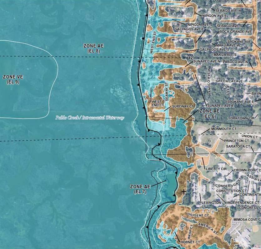
12 Flood Zone Changes at Jacksonville Beach (12 th Avenue South) 12


")


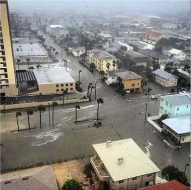


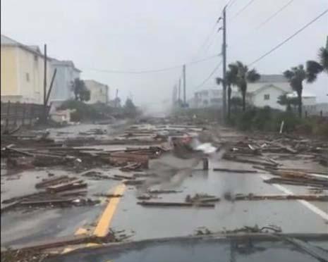


13 Hurricane Matthew Flooding (12 th Avenue South) Ref: Google Earth Ref: WTSP Ref: ABC News Ref: ActionNewJax 13

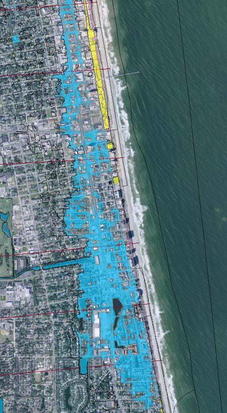
14 Hurricane Dora Flooding at Jacksonville Beach 14

15 Flood Zone Changes at Mayport Naval Station 15


16 Flood Zone Changes at Neptune Beach 16
17 Appeal and Comment Period Duval County and incorporated communities will have a 90-day appeal period for all changes to flood hazard information. Notice of changes will be published in the Federal Register and on the FEMA website. Notice of changes will be published in your local newspapers twice within a 10-day period. The second newspaper publication will begin the 90-day appeal period. Appeals are for flood hazard information changes 17
18 What Is an Appeal? The new or revised flood hazard information is believed to be scientifically or technically incorrect. The information is scientifically incorrect if: The methodology used and assumptions made in the determination of the information are inappropriate or incorrect. The information is technically incorrect if: The methodology was not applied correctly or was based on insufficient or poor-quality data. The methodology did not account for the effects of physical changes that have occurred in the floodplain. 18


19 Data Submission - Examples Storm Surge and Wave Analysis (i.e., revised ADCIRC/ SWAN or other) Revised WHAFIS Transects/ Analysis Revised Primary Frontal Dune Delineation Revised BFE and flood zones Newer Topo-Bathy Data Data Certifications from Professional Land Surveyors/ Engineers 19
20 Appeal and Comment Period (Cont d) Duval County and incorporated communities also will have a comment period. Comments do not involve BFEs and other flood hazard information. Comments include, but are not limited to, the following: Channel Names and Locations Road Names and Locations Corporate Limit Changes Requests for changes other than flood hazard information are considered comments 20
21 Appeal and Comment Period (Cont d) Please have appeals and comments directed to your local floodplain administrator. Your local floodplain administrator can submit all appeals and comments to: Christopher Mack AECOM 4016 Salt Pointe Parkway, Suite 200 North Charleston, SC We will not move forward until your appeals and comments are resolved. 21
22 Appeal Resolution Process After the 90-day appeal period has elapsed, FEMA will do the following: By a letter to the CEO, we will acknowledge receipt of all appeals submitted. We will review all appeals and the supporting data submitted with the appeal. If additional supporting data are required, we will request the data by letter. If appeals are not supported by data, we will inform the CEO by letter that the appeals are denied. 22
23 Appeal Resolution Process (Cont d) If appeals are adequately supported, we will revise the BFEs and any other information affected by the appeals. We will revise the FIRM if necessary. We will send the CEO a letter that explains the resolution of the appeals. We will provide the community with a 30-day period to review and comment on the resolution. We will issue a letter of final determination to the CEO once appeals and comments are resolved. 23
24 Letter of Final Determination After the 90-day appeal period and all appeals and comments have been resolved, FEMA will issue a Letter of Final Determination (LFD). Along with the LFD, we will send the Final Summary of Map Actions (SOMA), informing the community of Letters of Map Change that will be revalidated or superseded. The LFD begins a 6-month adoption/compliance period, during which the community will adopt the new maps into their floodplain ordinance. 24
25 Adoption/Compliance Period Communities may be contacted by FL State NFIP staff or by FEMA Region IV staff offering assistance with reviewing and updating their floodplain ordinance. Ordinance may require an update to adopt the new FIS report, FIRM, and all supporting technical data. Once the LFD letter is received, providing the effective date of the new FIS report and FIRM, the ordinance may be updated at any time. 25
26 Adoption/Compliance Period (Cont d) After adoption, a copy is sent to the FL State NFIP office and to FEMA Region IV for review. Update files showing the community s ordinance is NFIP compliant. If we do not receive the updated ordinance before the effective date, the community will be suspended from the NFIP Please begin the ordinance review process as soon as you receive the LFD! 26
27 Adoption/Compliance Period (Cont d) Technical support can be obtained by telephone at or by at For more information, please contact the Florida State NFIP Coordinator: Steve Martin 27
28 Effective FIRM After the adoption/compliance period ends, communities will receive: Paper copies of the effective FIRM panels and FIS report, as well as digital data A Revalidation Letter, informing the community of all Letters of Map Change that have been revalidated or superseded by the new FIRM 28
29 Opportunities to Update the FIRM A Flood Insurance Study Update is NOT the only time that your FIRM can be updated. The FIRM can be updated by: Letter of Map Amendment (LOMA), MT-1 Form Letter of Map Revision Based on Fill (LOMR-F), MT-1 Form Letter of Map Revision (LOMR), MT-2 Form 29
30 LOMA and LOMR-F (MT-1) Provides an administrative procedure whereby FEMA will review information submitted by an owner of property who believes that his or her property has been inadvertently included in a designated Special Flood Hazard Area (SFHA) 30
31 LOMR (MT-2) Applicable any time better data are available Based on the changes to the hydrologic or hydraulic characteristics of a flooding source, that results in the modification of the BFEs, regulatory floodway, and/or SFHA Is a modification to an effective FIRM and/or FIS report; officially revises the FIRM and/or FIS report 31
32 Risk and Flood Insurance Determine your flood risk Nearly everyone is at risk of flooding High Risk SFHA, identified as Zone A, Zone AE, Zone V, or Zone VE on FIRM Moderate Risk Identified as shaded Zone X on FIRM Low Risk Identified as unshaded Zone X on FIRM 32


33 Risk and Flood Insurance (Cont d) Requirements in a High-Risk Zone Federally regulated lenders making new loans or modifying existing loans secured by a building in the SFHA must require the borrower to purchase flood insurance for the term of the loan. 33


34 Duval Open House Meetings Duval County Open House Meetings #1 & #2 January 24, :00 AM 12:00 PM & 4:00 PM 7:00 PM Community Center and Exhibition Hall 2500 South Beach Parkway Jacksonville Beach, Florida Duval County Open House Meeting #3 January 25, :00 PM 7:00 PM Edward Ball Building 214 North Hogan Street Jacksonville, Florida
35 Outreach Planning & Path Forward Quarterly Outreach Update Calls Support throughout the regulatory process Local Elected Officials Updates Publication Overview and Placement Options 35


36 Questions and Answers Mark A. Vieira, PE Christina Lindemer Henrietta Williams, CFM Chris Mack, PE, PMP Mike Taylor, PE, CFM Danon Lucas Susan Wilson, CFM Janice Mitchell, CFM 36
St. Johns County, Florida Consultation Coordination Officer (CCO) Meeting. August 31, 2016 St. Augustine, Florida
 Meeting. August 31, 2016 St. Augustine, Florida") St. Johns County, Florida Consultation Coordination Officer (CCO) Meeting August 31, 2016 St. Augustine, Florida Agenda Introductions Coastal Study Update Study Process and Timeline Flood Insurance Implications
St. Johns County, Florida Consultation Coordination Officer (CCO) Meeting August 31, 2016 St. Augustine, Florida Agenda Introductions Coastal Study Update Study Process and Timeline Flood Insurance Implications
Nassau County, Florida Consultation Coordination Officer (CCO) Meeting. February 24, 2016 Fernandina Beach, Florida
 Meeting. February 24, 2016 Fernandina Beach, Florida") Nassau County, Florida Consultation Coordination Officer (CCO) Meeting February 24, 2016 Fernandina Beach, Florida Agenda Introductions Coastal Study Update Study Process and Timeline Flood Insurance Implications
Nassau County, Florida Consultation Coordination Officer (CCO) Meeting February 24, 2016 Fernandina Beach, Florida Agenda Introductions Coastal Study Update Study Process and Timeline Flood Insurance Implications
Taylor County, Florida Community Coordination and Outreach (CCO) Meeting
 Meeting") Taylor County, Florida Community Coordination and Outreach (CCO) Meeting Suwannee River Water Management District April 26, 2017 11:00AM to 12:00PM Taylor County Administration Building, 201 E. Green Street,
Taylor County, Florida Community Coordination and Outreach (CCO) Meeting Suwannee River Water Management District April 26, 2017 11:00AM to 12:00PM Taylor County Administration Building, 201 E. Green Street,
Martin County, Florida Consultation Coordination Officer (CCO) Meeting. March 22, 2018 Stuart, Florida
 Meeting. March 22, 2018 Stuart, Florida") Martin County, Florida Consultation Coordination Officer (CCO) Meeting March 22, 2018 Stuart, Florida Agenda Introductions Coastal Flood Risk Study Review Data Collected Storm Surge Modeling Overland Wave
Martin County, Florida Consultation Coordination Officer (CCO) Meeting March 22, 2018 Stuart, Florida Agenda Introductions Coastal Flood Risk Study Review Data Collected Storm Surge Modeling Overland Wave
Preliminary DFIRM Community Coordination (PDCC) Meeting Gilchrist & Levy Counties, FL. April 30, 2015
 Meeting Gilchrist & Levy Counties, FL. April 30, 2015") Preliminary DFIRM Community Coordination (PDCC) Meeting Gilchrist & Levy Counties, FL April 30, 2015 Agenda 1. Introductions 2. Study Process and Timeline 3. Overview of Preliminary Products 4. Overview
Preliminary DFIRM Community Coordination (PDCC) Meeting Gilchrist & Levy Counties, FL April 30, 2015 Agenda 1. Introductions 2. Study Process and Timeline 3. Overview of Preliminary Products 4. Overview
Middlesex County Timeline
 Community Coordination Meeting for Middlesex County, Connecticut Risk MAP Study November 9, 2011 Agenda Welcome and Introductions Project Timeline Coastal Flood Hazard Analysis Recap Public Review and
Bullitt County, Kentucky Preliminary DFIRM Community Open House. October 8, 2014 Shepherdsville, Kentucky
 Bullitt County, Kentucky Preliminary DFIRM Community Open House October 8, 2014 Shepherdsville, Kentucky Meeting Agenda Introductions Overview of Preliminary DFIRMs Overview of Map Appeal Process Questions
Community Coordination Meeting. York County, Maine. Risk MAP Study
 Community Coordination Meeting York County, Maine Risk MAP Study January 9, 2014 Agenda Welcome and Introductions Project Timeline Flood Hazard Analysis Recap (Digital Conversion, Riverine and Coastal)
Durham County Preliminary Flood Hazard Data Public Meeting. July 28, 2016
 Durham County Preliminary Flood Hazard Data Public Meeting July 28, 2016 Why Are We Here New flood hazard data has been released as Preliminary for Durham County Statutory Due Process for review/comments
Flood Map Revisions. Town of Nags Head Public Information and Input Session. December 14, 2016, 6 pm
 Flood Map Revisions Town of Nags Head Public Information and Input Session December 14, 2016, 6 pm Flood Map Revisions New preliminary flood maps released for Dare County June 30, 2016 www.nagsheadnc.gov/floodmaps
Abington Township Public Meeting
 Abington Township Public Meeting Flood Insurance Rate Map Update March 23, 2016 1 Meeting Agenda and Format Provide residents/property owners of Abington Township with information about the map update,
National Flood Insurance Program. Jennifer Gilbert, CFM, ANFI New Hampshire NFIP State Coordinator
 National Flood Insurance Program Jennifer Gilbert, CFM, ANFI New Hampshire NFIP State Coordinator What is the National Flood Insurance Program? Created by Congress in 1968 Participating Communities voluntarily
Community Coordination Meeting Sagadahoc County, Maine
 Community Coordination Meeting Sagadahoc County, Maine Risk MAP Study April 2, 2014 Agenda Welcome and Introductions Project Timeline Flood Hazard Analysis Recap Flood Risk Products Action: Hazard Mitigation
Enough about me! Topics Covered
 About Me Worked in land surveying since 1997 Employed by the City of Orlando since 2006 City of Orlando City Surveyor since February 2015 Certified Floodplain Manager since 2015 Florida Licensed Surveyor,
9/20/2016. Orange County Preliminary FIRM / Consultation Coordination Officer (CCO) Meeting
 Meeting") Orange County Preliminary FIRM / Consultation Coordination Officer (CCO) Meeting Open Pacific Coast Study September 21 and 22, 2016 1 Welcome and Introductions Preliminary FIRM / CCO Meeting Orange County
Orange County Preliminary FIRM / Consultation Coordination Officer (CCO) Meeting Open Pacific Coast Study September 21 and 22, 2016 1 Welcome and Introductions Preliminary FIRM / CCO Meeting Orange County
Cameron County, TX. Consultation Coordination Officer (CCO) Meeting. Please sign in (sheet at front of the room) Meeting will begin at 9:00
 Meeting. Please sign in (sheet at front of the room) Meeting will begin at 9:00") Cameron County, TX Consultation Coordination Officer (CCO) Meeting Please sign in (sheet at front of the room) Meeting will begin at 9:00 July 29, 2015 Lisa Jennings FEMA Region 6 Roles & Responsibilities
Cameron County, TX Consultation Coordination Officer (CCO) Meeting Please sign in (sheet at front of the room) Meeting will begin at 9:00 July 29, 2015 Lisa Jennings FEMA Region 6 Roles & Responsibilities
Physical Map Revisions as a Result of Updated Coastal Flood Hazards
 Physical Map Revisions as a Result of Updated Coastal Flood Hazards Agenda Coastal Flood Hazard Analysis Recap Public Review and Appeal Period Effect on Existing Letters of Map Change Insurance Questions
Updates to Maine Coastal Flood Insurance Rate Maps (FIRM s): What a Local Official Should Know. Presented by: Steve Johnson, P.E.
: What a Local Official Should Know. Presented by: Steve Johnson, P.E.") Updates to Maine Coastal Flood Insurance Rate Maps (FIRM s): What a Local Official Should Know Presented by: Steve Johnson, P.E. Town Engineer October 4, 2018 Introduction Federal Emergency Management
Updates to Maine Coastal Flood Insurance Rate Maps (FIRM s): What a Local Official Should Know Presented by: Steve Johnson, P.E. Town Engineer October 4, 2018 Introduction Federal Emergency Management
Federal Emergency Management Agency
 Page 1 of 4 Issue Date: April 11, 2013 Case No.: DETERMINATION DOCUMENT COMMUNITY AND REVISION INFORMATION PROJECT DESCRIPTION BASIS OF REQUEST Town Of Stratford Fairfield County Connecticut NO PROJECT
LOCAL OFFICIALS MEETING Lake Wausau Physical Map Revision MARATHON COUNTY, WISCONSIN FEBRUARY 9, 2017
 LOCAL OFFICIALS MEETING Lake Wausau Physical Map Revision MARATHON COUNTY, WISCONSIN FEBRUARY 9, 2017 Welcome & Introduction Michelle Staff Floodplain Management Policy Coordinator, WDNR Michelle.Staff@Wisconsin.gov
Community Officials Meeting. Plumas and Sierra County Physical Map Revision
 Community Officials Meeting Plumas and Sierra County Physical Map Revision March 6, 2014 Agenda Introductions/Sign In Project Scope Sierra Valley Flood Study (Plumas and Sierra Counties) North Yuba River
Federal Emergency Management Agency
 Page 1 of 4 Issue Date: February 14, 2013 Effective Date: June 28, 2013 DETERMINATION DOCUMENT COMMUNITY AND REVISION INFORMATION City of Sunny Isles Beach Miami-Dade County Florida PROJECT DESCRIPTION
N.C. Floodplain Mapping Program
 N.C. Floodplain Mapping Program Current Status and Update April 23, 2018 NCFMP Program Objectives Purpose: Develop, Maintain, and Disseminate current, accurate, digital flood hazard data for all of NC,
Southwest Florida Discovery Kick-Off Meeting. February 4, 2014
 Southwest Florida Discovery Kick-Off Meeting February 4, 2014 Agenda Introductions Outline Risk MAP products and datasets Project scoping and schedule Data gathered Next steps Gather stakeholder input/feedback
Preliminary Work Map Release
 Coastal Mapping in New Jersey Preliminary Work Map Release Monmouth County, New Jersey June 14, 2013 Agenda Introduction and Purpose of Briefing Hurricane Sandy Advisory Base Flood Elevations Transitioning
FEMA Region IX May 30-31, 2017
 Ventura County Preliminary Flood Maps FEMA Region IX May 30-31, 2017 National Flood Insurance Program U.S. Congress established the NFIP with the passage of the National Flood Insurance Act of 1968: 1.
OTTAWA COUNTY AND SANDUSKY COUNTY COMMUNITY CONSULTATION OFFICERS (CCO) MEETING December 7, 2017
 MEETING December 7, 2017") OTTAWA COUNTY AND SANDUSKY COUNTY COMMUNITY CONSULTATION OFFICERS (CCO) MEETING December 7, 2017 TODAY S AGENDA The Value of Updated Flood Maps for Your Community Reviewing the Updated Flood Risk Data
OTTAWA COUNTY AND SANDUSKY COUNTY COMMUNITY CONSULTATION OFFICERS (CCO) MEETING December 7, 2017 TODAY S AGENDA The Value of Updated Flood Maps for Your Community Reviewing the Updated Flood Risk Data
Herkimer County, New York Flood Hazard Mapping Status Report for Property Owners
 Herkimer County, New York Flood Hazard Mapping Status Report for Property Owners Herkimer County, New York Flood Hazard Mapping Status Report for Property Owners FLOOD INSURANCE Who Should Purchase Flood
Federal Emergency Management Agency
 Page 1 of 3 COMMUNITY AND MAP PANEL INFORMATION COMMUNITY CITY OF MARGATE CITY, ATLANTIC COUNTY, NEW JERSEY LEGAL PROPERTY DESCRIPTION A parcel of land, as described in Deed recorded in Book 4826, page
Kevin Wagner Maryland Department of the Environment
 Kevin Wagner Maryland Department of the Environment Topics Overview of the National Flood Insurance Program (NFIP) Mapping Regulations Insurance Mitigation Community Rating System (CRS) Questions Know
Federal Emergency Management Agency
 Page 1 of 4 Issue Date: August 1, 2012 Effective Date: December 13, 2012 Case No.: 12-06-0595P LOMR-APP Washington, D.C. 20472 LETTER OF MAP REVISION DETERMINATION DOCUMENT COMMUNITY AND REVISION INFORMATION
Federal Emergency Management Agency
 Page 1 of 4 Issue Date: April 26, 2013 DETERMINATION DOCUMENT COMMUNITY AND REVISION INFORMATION PROJECT DESCRIPTION BASIS OF REQUEST City of Coppell Dallas County Texas FILL HYDRAULIC ANALYSIS NEW TOPOGRAPHIC
Federal Emergency Management Agency
 Page 1 of 5 Issue Date: July 27, 2012 Effective Date: December 10, 2012 Case No.: 11-06-4512P Follows Conditional Case No.: 06-06-B789R LOMR-APP Federal Emergency Management Agency Washington, D.C. 20472
REAL ESTATE FLOOD DISCLOSURE PROGRAM & FLOOD MAP INFORMATION SERVICES
 REAL ESTATE FLOOD DISCLOSURE PROGRAM & FLOOD MAP INFORMATION SERVICES Lisa Foster, CFM, Floodplain Coordinator ldfoster@pinellascounty.org January 26, 2018 Why are you here? Save your clients money on
Federal Emergency Management Agency
 Page 1 of 4 Issue Date: September 7, 2012 Effective Date: January 22, 2013 DETERMINATION DOCUMENT COMMUNITY COMMUNITY AND REVISION INFORMATION City of Lubbock Lubbock County Texas PROJECT DESCRIPTION CHANNELIZATION
Location: Tampa, Florida March 6, 2013
 Discovery Meeting: West Florida Coastal Study Location: Tampa, Florida March 6, 2013 Agenda Introductions Why we are here Outline Risk MAP products and datasets Discovery Overview: Project scoping and
Skagit County Flood Insurance Study Update. Ryan Ike, CFM FEMA Region 10
 Skagit County Flood Insurance Study Update Ryan Ike, CFM FEMA Region 10 Skagit County Flood Insurance Study Process Overview Process, Schedule, & Deliverables Base Flood Elevations, Modeling, & Levees
If you have any questions or concerns please give us a call at , or Walter Jenkins at (ext 300).
.") FLORIDA ZONE SERVICES Flood Insurance and Zone Consulting 461 SE 3 rd Terrace Pompano Beach, FL 33060 Phone 954-290-7420 bspencer@florida-floodzone.com March 6, 2014 Dear Pebblebrook II Homeowner: We informing
FLORIDA ZONE SERVICES Flood Insurance and Zone Consulting 461 SE 3 rd Terrace Pompano Beach, FL 33060 Phone 954-290-7420 bspencer@florida-floodzone.com March 6, 2014 Dear Pebblebrook II Homeowner: We informing
WAYNE COUNTY COMMUNITY CONSULTATION OFFICERS (CCO) MEETING. February 27, 2019
 MEETING. February 27, 2019") WAYNE COUNTY COMMUNITY CONSULTATION OFFICERS (CCO) MEETING February 27, 2019 TODAY S AGENDA Review the Updated Flood Risk Data for Your County Next Steps in the Map Adoption Process Understanding Flood
WAYNE COUNTY COMMUNITY CONSULTATION OFFICERS (CCO) MEETING February 27, 2019 TODAY S AGENDA Review the Updated Flood Risk Data for Your County Next Steps in the Map Adoption Process Understanding Flood
Bucks County, PA Flood Risk Review Meeting. November 2014
 Bucks County, PA Flood Risk Review Meeting November 2014 Agenda for Today Risk MAP Program overview Overview of non-regulatory Flood Risk Products and datasets Discuss mitigation action Technical overview
Calhoun County Flood Insurance Study Update
 Calhoun County Flood Insurance Study Update Larry Voice FEMA Region VI September 18, 2009 AGENDA Introduction Study Overview and Status Update Levees Post-Preliminary Process Outreach Moving Forward 2
Introduction to the National Flood Insurance Program: A Guide for Coastal Property Owners MAINE BEACHES CONFERENCE 2017
 Introduction to the National Flood Insurance Program: A Guide for Coastal Property Owners MAINE BEACHES CONFERENCE 2017 SUE BAKER, CFM STATE NFIP COORDINATOR MAINE DEPT OF AGRICULTURE, CONSERVATION & FORESTRY
Federal Emergency Management Agency
 Page 1 of 5 Issue Date: June 21, 2013 Follows Conditional Case No.: 04-06-A148R DETERMINATION DOCUMENT COMMUNITY COMMUNITY AND REVISION INFORMATION City of Irving Dallas County Texas FILL PROJECT DESCRIPTION
NFIP Mapping Issues. Wendy Lathrop, PLS, CFM. Cadastral Consulting, LLC
 NFIP Mapping Issues Cadastral Consulting, LLC NFIP Basic Objectives: Reduce the exposure to flood damages through the use of minimum standards for the placement and design of structures located in flood
FLOODPLAIN FAQ s. Last Update: June 2017
 FLOODPLAIN FAQ s Last Update: June 2017 What does FEMA stand for? Federal Emergency Management Agency - the operation of FEMA is to lead America to prepare for, prevent, respond to, and recover from disasters.
Questions about the National Flood Insurance Program
 Questions about the National Flood Insurance Program Federal Emergency Management Agency (FEMA) Questions and Answers What is the National Flood Insurance Program (NFIP)? The NFIP is a Federal program
THE FEDERAL EMERGENCY MANAGEMENT AGENCY. Letters of Map Change Kristen Martinenza, P.E., CFM FEMA Region IV
 THE FEDERAL EMERGENCY MANAGEMENT AGENCY Letters of Map Change Presented by: Kristen Martinenza, P.E., CFM FEMA Region IV 1 NATIONAL FLOOD INSURANCE ACT OF 1968 At the start of the program, there was not
FOR LOCAL GOVERNMENTS
 FLOOD MAP OUTREACH PLANNING GUIDEBOOK FOR LOCAL GOVERNMENTS Version 1.1 Georgia Department of Natural Resources March 2010 Dear Community Official: Georgia s Department of Natural Resources (DNR) has partnered
National Flood Insurance Program (NFIP) for Real Estate Professionals
 for Real Estate Professionals") National Flood Insurance Program (NFIP) for Real Estate Professionals 1 Joshua Oyer, CFM Outreach Specialist NFIP State Coordinator s Office at the Texas Water Development Board 2 Outline Introduction
National Flood Insurance Program (NFIP) for Real Estate Professionals 1 Joshua Oyer, CFM Outreach Specialist NFIP State Coordinator s Office at the Texas Water Development Board 2 Outline Introduction
SUPERHERO!!! Elevation Certificate. You are about to go from SURVEYOR 2/18/2019
 Karol L. Grove Licensed Professional Surveyor Certified Floodplain Manager Elevation Certificate No longer the Animal it used to be When are they needed??? You are about to go from SURVEYOR to SUPERHERO!!!
Coastal Flood Insurance Studies in Virginia and Climate Change
 Coastal Flood Insurance Studies in Virginia and Climate Change VFMA Floodplain Management Workshop October 22, 2015 Jeff Gangai Why is a Coastal Restudy Needed? New Guidelines need to be implemented Atlantic
INSTRUCTIONS FOR COMPLETING THE APPLICATION FORMS FOR CONDITIONAL LETTERS OF MAP REVISION AND LETTERS OF MAP REVISION
 INSTRUCTIONS FOR COMPLETING THE APPLICATION FORMS FOR CONDITIONAL LETTERS OF MAP REVISION AND LETTERS OF MAP REVISION GENERAL In 1968, the U.S. Congress passed the National Flood Insurance Act, which created
Federal Emergency Management Agency
 Page 1 of 6 Issue Date: October 24, 2012 Effective Date: March 7, 2013 Case No.: LOMR-APP DETERMINATION DOCUMENT COMMUNITY AND REVISION INFORMATION PROJECT DESCRIPTION BASIS OF REQUEST City of Lubbock
Pinellas County Flood Map Information Service & Real Estate Disclosure Program Training January 26, 2017 COMMON FLOODPLAIN ACRONYMS
 FEMA ASFPM BFE CAV Pinellas County Flood Map Information Service & Real Estate Disclosure Program Training COMMON FLOODPLAIN ACRONYMS Federal Emergency Management Agency Association of State Floodplain
Consultation Coordination Officer (CCO) Meeting
 Meeting") Consultation Coordination Officer (CCO) Meeting Middle Brazos Lake Whitney Physical Map Revision Hill and McLennan Counties FEMA Region 6 Agenda National Flood Insurance Program Purpose of the Meeting
Consultation Coordination Officer (CCO) Meeting Middle Brazos Lake Whitney Physical Map Revision Hill and McLennan Counties FEMA Region 6 Agenda National Flood Insurance Program Purpose of the Meeting
Floodplain Management 101: UNIT II. Maps & Flood Insurance Studies
 Floodplain Management 101: UNIT II Maps & Flood Insurance Studies Who is ASFPM? ASFPM stands for the Association of State Floodplain Managers A national organization of floodplain management professionals
Door County Floodplain Program Informational Meeting
 Door County Floodplain Program Informational Meeting Door County Land Use Services Department Wisconsin Department of Natural Resources January 15, 2018 Floodplain = Land affected by flood event with a
Flood Analysis Memo. 629 Orangewood Dr. Dunedin, FL BFE = 21 ft
 Flood Analysis Memo Property Address 629 Orangewood Dr. In Partnership with: ** This property is NOT within a high-risk flood zone ** 629 Orangewood Dr. BFE = 21 ft This property is located in the FEMA
MT-1 Basics: A Comprehensive Overview of LOMAs and Discussion of Common Application Setbacks
 MT-1 Basics: A Comprehensive Overview of LOMAs and Discussion of Common Application Setbacks Introduction: Terminology MT-1s vs. MT-2s LOMAs vs. LOMRs What is a LOMC? Letters of Map Change (LOMCs) MT-1s
King County, WA DFIRM Update and Seclusion Process. Webinar June 14, 2016
 King County, WA DFIRM Update and Seclusion Process Webinar June 14, 2016 Agenda King County DFIRM Study History What is/has been done Process for moving forward Seclusion Seclusion mapping process Seclusion
NFIP Overview Elevation Certificate Flood Insurance Rate Maps. By: Maureen O Shea, AICP, CFM State NFIP Coordinator
 NFIP Overview Elevation Certificate Flood Insurance Rate Maps By: Maureen O Shea, AICP, CFM State NFIP Coordinator Example of a flood failure Example of a flood failure Purposes of the NFIP Identify &
Federal Emergency Management Agency
 Page 1 of 5 Issue Date: April 2, 2015 DETERMINATION DOCUMENT COMMUNITY AND REVISION INFORMATION PROJECT DESCRIPTION BASIS OF REQUEST Ventura County California NO PROJECT UPDATE COMMUNITY (Unincorporated
The New Maryland Model Floodplain Management Ordinance
 Department of the Environment The New Maryland Model Floodplain Management Ordinance MAFSM Conference October 21, 2010 Kevin G. Wagner Agenda Brief history/background What s driving new ordinances Introduction
BEING PREPARED FOR MAP CHANGES What to Know; What to Say National Flood Conference May 16, 2016
 BEING PREPARED FOR MAP CHANGES What to Know; What to Say National Flood Conference May 16, 2016 0 Discussion Topics Risk MAP Program Background Eric Simmons FEMA Region 9 Map Change Rating Options Edie
Erie County Flood Risk Review Meeting. January 18, 2018
 Erie County Flood Risk Review Meeting January 18, 2018 Agenda The value of updated flood maps for your community Review updated flood-risk data and important next steps in the Risk MAP process Increasing
SECTION 9: MAPS AND DATA
 SECTION 9: MAPS AND DATA Contents 9.1. NFIP Maps and Data... 9-2 9.1.1. Adopting and enforcing NFIP floodplain maps and data... 9-2 9.1.2. Adopting and enforcing more restrictive data... 9-2 9.1.3. Annexations...
Flood Risk Review (FRR) Meeting. Cumberland County, Pennsylvania Carlisle, Pennsylvania December 5, 2016
 Meeting. Cumberland County, Pennsylvania Carlisle, Pennsylvania December 5, 2016") Flood Risk Review (FRR) Meeting Cumberland County, Pennsylvania Carlisle, Pennsylvania December 5, 2016 Why are we here today? The Flood Insurance Study (FIS) report and Flood Insurance Rate Maps (FIRMs)
Flood Risk Review (FRR) Meeting Cumberland County, Pennsylvania Carlisle, Pennsylvania December 5, 2016 Why are we here today? The Flood Insurance Study (FIS) report and Flood Insurance Rate Maps (FIRMs)
National Coastal Outreach
 National Coastal Outreach Answering Tough Questions June 11, 2013 Why Focus on Coastal Flood Risk? 120,475,000 people or 39% of the U.S. population live in counties subject to the 1% annual chance coastal
Flood Plain Management Services (FPMS) Program
 Program") Flood Plain Management Services (FPMS) Program 2016 Winter Stakeholder Partnering Forum March 2016 Mario Beddingfield, P.E., CFM Hydraulic Engineer/FPMS Program Manager H&H/Water Control Branch U.S. Army
Flood Plain Management Services (FPMS) Program 2016 Winter Stakeholder Partnering Forum March 2016 Mario Beddingfield, P.E., CFM Hydraulic Engineer/FPMS Program Manager H&H/Water Control Branch U.S. Army
COLLIER COUNTY FLOODPLAIN MANAGEMENT
 COLLIER COUNTY FLOODPLAIN MANAGEMENT FREQUENTLY ASKED QUESTIONS The following information is based on common questions from the public. If you have a specific question or need further information, please
Sandy + BW-12: Changing the Equation for Building Safer, More Resilient Communities
 Sandy + BW-12: Changing the Equation for Building Safer, More Resilient Communities Grant Smith Jerry Sparks Jean Huang Ken Logsdon Stephanie Routh Session Agenda Moderators: Grant Smith & Jerry Sparks
Federal Emergency Management Agency
 Page 1 of 4 Issue Date: October 2, 2017 Effective Date: October 2, 2017 Case No.: 17-09-2731P LOMR-APP Federal Emergency Management Agency Washington, D.C. 20472 LETTER OF MAP REVISION DETERMINATION DOCUMENT
If you have any questions or concerns please give us a call at , or Walter Jenkins at (ext 300).
.") FLORIDA FLOODZONE SERVICES Flood Insurance and Zone Consulting 461 SE 3 rd Terrace Pompano Beach, FL 33060 Phone 954-290-7420 bspencer@florida-floodzone.com March 15, 2010 Dear Portofino Lakes Homeowner:
FLORIDA FLOODZONE SERVICES Flood Insurance and Zone Consulting 461 SE 3 rd Terrace Pompano Beach, FL 33060 Phone 954-290-7420 bspencer@florida-floodzone.com March 15, 2010 Dear Portofino Lakes Homeowner:
History of Floodplain Management in Ascension Parish
 History of Floodplain Management in Ascension Parish presented by: Kara Moree Floodplain Coordinator February 6, 2012 Floodplain 101 Floodplain 101 Base or 1% Flood: A flood having a 1% chance of being
210 W Canal Dr Palm Harbor, FL 34684
 Flood Analysis Memo Property Address In Partnership with: ** This property is within a high risk flood zone ** BFE = 6 ft This property is located in the FEMA designated high-risk zone, Zone AE - an area
Using GISWeb to Determine Your Property s Flood Zone
 Using GISWeb to Determine Your Property s Flood Zone 1. In a new browser window, go to http://www.co.santacruz.ca.us/departments/geographicinformationsystemsgis.aspx 2. Click on GISWeb - GIS Mapping Application
10526 Bermuda Isle Dr. Tampa, FL 33647
 Flood Analysis Memo Property Address In Partnership with: ** This property is NOT within a high-risk flood zone ** This property is located in a FEMA low-risk zone designated as Zone X - an area of minimal
Table 1: Federal, State and Local Government Rules applicable to LOMRs/CLOMRS submittal
 MnDNR LOMC Guide This document has been prepared by the Minnesota Department of Natural Resources floodplain staff and is intended to provide assistance with LOMR/CLOMR submittals. This information is
JAXGIS FEMA Flood Hazard Mapping -- Frequently Asked Questions
 Flood Hazard Zone Designations Summary Zones starting with the letter 'A' (for instance, Zone A, Zone AE, Zone AH, Zone AO) denote a Special Flood Hazard Area, which can also be thought of as the 100-year
What Was Updated in 2004 in Hennepin Countywide Maps?
 What Was Updated in 2004 in Hennepin Countywide Maps? Combined the city and township maps into one countywide index Done by USACE Mainly digital capture of old floodplain boundaries; some spots with shifts
Federal Emergency Management Agency
 Page 1 of 6 Issue Date: May 13 2016 Case No.: Follows Conditional Case No.: 14-05-0595R DETERMINATION DOCUMENT COMMUNITY AND REVISION INFORMATION PROECT DESCRIPTION BASIS OF REQUEST COMMUNITY Village of
Using Non-Regulatory RiskMAP Products in Floodplain Management. Ferrin Affleck, PE, CFM, Water Resources Engineer Project Manager Atkins
 Using Non-Regulatory RiskMAP Products in Floodplain Management Ferrin Affleck, PE, CFM, Water Resources Engineer Project Manager Atkins 1 Goal of this Presentation Inform Peak interest Stimulate creativity
Federal Emergency Management Agency
 Page 1 of 5 Issue Date: October 16, 2014 Effective Date: March 2, 2015 Case No.: 14-09-2279P LOMR-APP Federal Emergency Management Agency Washington, D.C. 20472 LETTER OF MAP REVISION DETERMINATION DOCUMENT
Panel Decision & Report. SRP MAES Ring s Island, Salisbury, Essex County, Massachusetts
 Panel Decision & Report SRP MAES042211 Ring s Island, Salisbury, Essex County, Massachusetts Table of Contents Summary... 2 About the Scientific Resolution Panel (SRP) and Authority... 2 Panel Members...
National Flood Insurance Program BW-12
 National Flood Insurance Program BW-12 Janice Mitchell, Insurance Specialist, Floodplain Management and Insurance Branch FEMA, Region 4 Janice.mitchell@fema.dhs.gov Biggert-Waters 2012 - What Everyone
Orange County Flood Insurance Study Update
 Orange County Flood Insurance Study Update Larry Voice FEMA Region VI August 26, 2009 AGENDA Introduction Study Overview and Status Update Levees Post-Preliminary Process Outreach Moving Forward 2 Introduction
Georgia Flood M.A.P. Program Risk MAP Plenary Session GAFM 2011
 Georgia Flood M.A.P. Program Risk MAP Plenary Session GAFM 2011 Collis Brown, Georgia DNR March 24, 2011 GA Flood Map Modernization Responsible for end-to-end production Developed aggressive outreach program
THE $64,000 FLOOD INSURANCE BILL
 THE $64,000 FLOOD INSURANCE BILL GEORGIA ASSOCIATION OF FLOODPLAIN MANAGERS 9 TH ANNUAL TECHNICAL CONFERENCE Patrick Gervais, PE, CFM A CASE STUDY IN FLOOD INSURANCE This is a true story that happened
Federal Emergency Management Agency
 Page 1 of 4 Issue ate: May 18, 2012 Follows Conditional Case No.: 08-06-1597R ETERMINATION OCUMENT COMMUNITY AN REVISION INFORMATION PROJECT ESCRIPTION BASIS OF REQUEST COMMUNITY Harris County Texas (Unincorporated
Federal Emergency Management Agency
 age 1 of 4 Issue Date: April 16, 2013 Effective Date: August 30, 2013 DETERMINATION DOCUMENT COMMUNITY AND REVISION INFORMATION ROJECT DESCRITION BASIS OF REQUEST City of Naples Collier County Florida
Mistakes on Elevation Certificates
 Mistakes on Elevation Certificates What is the Base Flood Elevation (BFE) & how do you determine it? FIRM Map Panel? Flood Insurance Study? o Profile Sheet o Floodway Data Chart o Stillwater Chart Community
REAL ESTATE FLOOD DISCLOSURE PROGRAM & FLOOD MAP INFORMATION SERVICES
 REAL ESTATE FLOOD DISCLOSURE PROGRAM & FLOOD MAP INFORMATION SERVICES Agenda 10:30-12:00 Flood Disclosure Program 12:00-12:30 Lunch 12:30-1:30 Flood Map Service Center Lisa Foster, CFM, Floodplain Coordinator
Federal Emergency Management Agency
 Page 1 of 5 Issue Date: October 19, 2012 Effective Date: March 4, 2013 Case No.: 12-06-3459P LOMR-APP Washington, D.C. 20472 LETTER OF MAP REVISION DETERMINATION DOCUMENT COMMUNITY AND REVISION INFORMATION
Northern Alameda County Consultation Coordination Officer (CCO) Meeting
 Meeting") MEETING TITLE: DATE AND TIME: Northern Alameda County Consultation Coordination Officer (CCO) Meeting May 27, 2015, 1:30 to 3:30 p.m. LOCATION: 950 West Mall Square, Room 201 Alameda, CA ATTENDEES: Eric
MEETING TITLE: DATE AND TIME: Northern Alameda County Consultation Coordination Officer (CCO) Meeting May 27, 2015, 1:30 to 3:30 p.m. LOCATION: 950 West Mall Square, Room 201 Alameda, CA ATTENDEES: Eric
10526 Bermuda Isle Dr. Tampa, FL 33647
 Flood Analysis Memo Property Address 10526 Bermuda Isle Dr. In Partnership with: ** This property is NOT within a high-risk flood zone ** 10526 Bermuda Isle Dr. BFE = 35 ft This property is located in
Federal Emergency Management Agency
 Federal Emergency Management Agency Washington, D.C. 20472 August 16, 2016 CERTIFIED MAIL IN REPLY REFER TO: RETURN RECEIPT REQUESTED Case No.: 16-07-1180P Community Name: City of Overland Park, KS The
Requirements for Construction on Properties in the Special Flood Hazard Area (SFHA)
") Requirements for Construction on Properties in the Special Flood Hazard Area (SFHA) Rev 010915 The website for the IDNR to request the EFARA (Electronic Floodplain Analysis/Regulatory Assessment is found
Requirements for Construction on Properties in the Special Flood Hazard Area (SFHA) Rev 010915 The website for the IDNR to request the EFARA (Electronic Floodplain Analysis/Regulatory Assessment is found
July 31, 2017 NFIP Flood Map Open House Flood Maps 101 Flood Mapping acronyms History of the NFIP Flood Mapping Updates Flood Insurance Fairhope,
 July 31, 2017 NFIP Flood Map Open House Flood Maps 101 Flood Mapping acronyms History of the NFIP Flood Mapping Updates Flood Insurance Fairhope, Alabama Flood Maps Fairhope Permitting Jurisdiction Coastal
Now forget it all for the next 90 minutes.
 Karol L. Grove, PS Get ready to think outside of the box. Get ready to think about surveying, flood zones and flood insurance in a whole new light.. Think about everything you think you know about Elevation
Coastal Flood Maps. Chris Penney. Program Manager USACE Baltimore District 2 June US Army Corps of Engineers BUILDING STRONG
 Coastal Flood Maps Chris Penney Program Manager USACE Baltimore District 2 June 2015 US Army Corps of Engineers There are two types of coastal flood risk maps They look different They communicate different