SUPERHERO!!! Elevation Certificate. You are about to go from SURVEYOR 2/18/2019
|
|
|
- Estella Richards
- 5 years ago
- Views:
Transcription


1 Karol L. Grove Licensed Professional Surveyor Certified Floodplain Manager Elevation Certificate No longer the Animal it used to be When are they needed??? You are about to go from SURVEYOR to SUPERHERO!!! 1


2 Get ready to think outside of the box. Get ready to think about flood zones and flood insurance in a whole new light.. Think about everything you think you know about Flood Zones & Elevation Certificates... Now forget it all for the next few hours!! WHY? 2

3 FLOOD MAPS USA 3

4 NEW FLOOD MAPS 83 COUNTIES 83 COUNTIES MICHIGAN 55 COUNTIES HAVE NEW MAPS New Flood Maps How accurate are they? 4


5 SURVEYORS / FLOOD ZONES What YOU will need to know: 5
6 FLOOD ZONES - PART 1 Field Procedures.what YOU will need to know: FLOOD ZONES - PART 2 (continued) FLOOD ZONES - PART 2 (continued) 6


7 2013 Downtown Grand Rapids 2013 Downtown Grand Rapids 7
8 What is a Flood Zone? 100 year or 1% Zone AE, A1 A30, A AO, AH, V, VE Base Flood Zone 100 year flood zone 1% flood zone Special flood zone hazard area Most Common Types of Flood Zones Zone AE, A1-A30 (Studied Area) Zone A (Non-Studied Area) Zone AO & AH (Elevation Not Determined) Zone V (BFE Unknown) or VE (BFE Known) Zone X shaded or Zone B (100 yr to 500 yr) Zone X un-shaded or Zone C (greater than 500 yr) 8

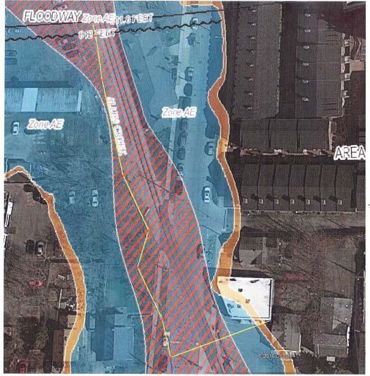
9 Floodway: Area of moving water High hazard area Needed to carry flood waters Highway for the water New Maps / Flood Zones / Floodways 9


10 Let me tell you a FLOODWAY story... 10
11 History..FLOOD MAPS 1968 National Flood Insurance Act 1977 Michigan (1 st FIRM) 1973 Flood Disaster Protection Act 1986 FEMA Community Probation Procedures 1994 National Flood Insurance Reform Act 2004 Flood Insurance Reform Act 2005 Katrina 2006 Beginning of New Flood Maps 2012 Biggert Waters Act (2014 Affordability Act) Elevation Certificate No longer the Animal it used to be When are they needed??? LOMA??????? LETTER OF MAP AMENDMENT 11

 Zone A-Stillwater (w/bfe) Zone A")
 Zone A - BFE Unknown Fill LOMR-F LETTER OF MAP")
12 LOMA Types 1. Electronic LOMA / eloma 2. On-Line LOMC 3. Out as Shown LOMA 4. LOMR-F 5. CLOMA & CLOMR-F eloma vs. On Line LOMC Single or Multiple Structures (w/bfe) Single or Multiple Parcels (w/bfe) Zone A-Stillwater (w/bfe) Zone A with BFE known Out As Shown Floodway Condominium Unit (multi-owners) Zone A - BFE Unknown Fill LOMR-F LETTER OF MAP AMENDMENT (LOMA) 12


: Letter")

13 ELEVATION CERTIFICATE PLAN B People are losing their homes due to the high cost of flood premiums! YIKES! History.FLOOD MAPS FIRMs Are Not Set In Stone Processes Available To Correct Or Change A Federal Insurance Rate Map (FIRM): Letter of Map Amendment (LOMA) Letter of Map Revision based on fill (LOMR-F) Physical Map Revision 13

14 Shooting the Structure Checking the LAG Would this house qualify for a LOMA application? Establishing the BFE AE, A1 A30 Zone FLOOD INSURANCE STUDY (FIS) Not the FIRM 14
 Google FEMA Map")

15 How do we get to? FLOOD INSURANCE STUDY (FIS) Google FEMA Map Service Center Click on Search All Products THE FLOOD INSURANCE STUDY (FIS) 15

 16")
16 THE FLOOD INSURANCE STUDY (FIS) 16

17 Establishing the BFE Establishing the BFE 17
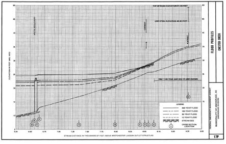
18 Establishing the BFE The Flood Insurance Study Profile Sheet 18

19 The Flood Insurance Study Profile Sheet 19
 Only on the Studied Areas (AE, A1 A30, V Zones)")

20 Establishing a Base Flood Elevation THE FLOOD INSURANCE STUDY (FIS) Only on the Studied Areas (AE, A1 A30, V Zones) 3 important places in the FIS The Stillwater Chart Floodway Data Chart Profile Sheets Establishing a Base Flood Elevation 20
SUPERHERO!!! You are about to go from SURVEYOR 1/9/2019. Karol L. Grove Licensed Professional Surveyor Certified Floodplain Manager
 Karol L. Grove Licensed Professional Surveyor Certified Floodplain Manager 1 You are about to go from SURVEYOR to SUPERHERO!!! 2 Get ready to think outside of the box. Get ready to think about flood zones
Now forget it all for the next 90 minutes.
 Karol L. Grove, PS Get ready to think outside of the box. Get ready to think about surveying, flood zones and flood insurance in a whole new light.. Think about everything you think you know about Elevation
MT-1 Basics: A Comprehensive Overview of LOMAs and Discussion of Common Application Setbacks
 MT-1 Basics: A Comprehensive Overview of LOMAs and Discussion of Common Application Setbacks Introduction: Terminology MT-1s vs. MT-2s LOMAs vs. LOMRs What is a LOMC? Letters of Map Change (LOMCs) MT-1s
Zone A. Non Studied Area? Where do we go? Establishing the BFE. Bridge Design 1/9/2019
 Karol L. Grove Licensed Professional Surveyor Certified Floodplain Manager 1 Establishing the BFE Zone A Where do we go? Non Studied Area? 2 Bridge Design 3 1 4 5 6 2 Look at the age of the culvert or
Mistakes on Elevation Certificates
 Mistakes on Elevation Certificates What is the Base Flood Elevation (BFE) & how do you determine it? FIRM Map Panel? Flood Insurance Study? o Profile Sheet o Floodway Data Chart o Stillwater Chart Community
THE FEDERAL EMERGENCY MANAGEMENT AGENCY. Letters of Map Change Kristen Martinenza, P.E., CFM FEMA Region IV
 THE FEDERAL EMERGENCY MANAGEMENT AGENCY Letters of Map Change Presented by: Kristen Martinenza, P.E., CFM FEMA Region IV 1 NATIONAL FLOOD INSURANCE ACT OF 1968 At the start of the program, there was not
Requirements for Construction on Properties in the Special Flood Hazard Area (SFHA)
") Requirements for Construction on Properties in the Special Flood Hazard Area (SFHA) Rev 010915 The website for the IDNR to request the EFARA (Electronic Floodplain Analysis/Regulatory Assessment is found
Requirements for Construction on Properties in the Special Flood Hazard Area (SFHA) Rev 010915 The website for the IDNR to request the EFARA (Electronic Floodplain Analysis/Regulatory Assessment is found
FLOODPLAIN FAQ s. Last Update: June 2017
 FLOODPLAIN FAQ s Last Update: June 2017 What does FEMA stand for? Federal Emergency Management Agency - the operation of FEMA is to lead America to prepare for, prevent, respond to, and recover from disasters.
NFIP Mapping Issues. Wendy Lathrop, PLS, CFM. Cadastral Consulting, LLC
 NFIP Mapping Issues Cadastral Consulting, LLC NFIP Basic Objectives: Reduce the exposure to flood damages through the use of minimum standards for the placement and design of structures located in flood
Durham County Preliminary Flood Hazard Data Public Meeting. July 28, 2016
 Durham County Preliminary Flood Hazard Data Public Meeting July 28, 2016 Why Are We Here New flood hazard data has been released as Preliminary for Durham County Statutory Due Process for review/comments
Preliminary DFIRM Community Coordination (PDCC) Meeting Gilchrist & Levy Counties, FL. April 30, 2015
 Meeting Gilchrist & Levy Counties, FL. April 30, 2015") Preliminary DFIRM Community Coordination (PDCC) Meeting Gilchrist & Levy Counties, FL April 30, 2015 Agenda 1. Introductions 2. Study Process and Timeline 3. Overview of Preliminary Products 4. Overview
Preliminary DFIRM Community Coordination (PDCC) Meeting Gilchrist & Levy Counties, FL April 30, 2015 Agenda 1. Introductions 2. Study Process and Timeline 3. Overview of Preliminary Products 4. Overview
Floodplain Management 101. Mississippi Emergency Management Agency Floodplain Management Bureau
 Floodplain Management 101 Mississippi Emergency Management Agency Floodplain Management Bureau Stafford Act The Stafford Disaster Relief and Emergency Assistance Act (Stafford Act) (Public Law 100-707)
Using GISWeb to Determine Your Property s Flood Zone
 Using GISWeb to Determine Your Property s Flood Zone 1. In a new browser window, go to http://www.co.santacruz.ca.us/departments/geographicinformationsystemsgis.aspx 2. Click on GISWeb - GIS Mapping Application
210 W Canal Dr Palm Harbor, FL 34684
 Flood Analysis Memo Property Address In Partnership with: ** This property is within a high risk flood zone ** BFE = 6 ft This property is located in the FEMA designated high-risk zone, Zone AE - an area
Enough about me! Topics Covered
 About Me Worked in land surveying since 1997 Employed by the City of Orlando since 2006 City of Orlando City Surveyor since February 2015 Certified Floodplain Manager since 2015 Florida Licensed Surveyor,
National Flood Insurance Program Changes Effective April 1, 2016
 National Flood Insurance Program Changes Effective April 1, 2016 Beginning April 1, 2016, the National Flood Insurance Program (NFIP) will begin implementing additional flood insurance program changes
Abington Township Public Meeting
 Abington Township Public Meeting Flood Insurance Rate Map Update March 23, 2016 1 Meeting Agenda and Format Provide residents/property owners of Abington Township with information about the map update,
JAXGIS FEMA Flood Hazard Mapping -- Frequently Asked Questions
 Flood Hazard Zone Designations Summary Zones starting with the letter 'A' (for instance, Zone A, Zone AE, Zone AH, Zone AO) denote a Special Flood Hazard Area, which can also be thought of as the 100-year
Role of the Local Floodplain Administrator
 2/22/2016 Role of the Local Floodplain Administrator Marsha Hilmes-Robinson Floodplain Administrator City of Fort Collins, Colorado mhilmesrobinson@fcgov.com 1 Partnership Engineer/Architect/ Contractor
THE $64,000 FLOOD INSURANCE BILL
 THE $64,000 FLOOD INSURANCE BILL GEORGIA ASSOCIATION OF FLOODPLAIN MANAGERS 9 TH ANNUAL TECHNICAL CONFERENCE Patrick Gervais, PE, CFM A CASE STUDY IN FLOOD INSURANCE This is a true story that happened
Key Fundamentals of Flood Insurance
 a Welcome to Key Fundamentals of Flood Insurance An entry-level approach for real estate professionals [Photo credit: Oliver Gruener] We will get started in a few minutes. Presented Meanwhile, by: let
Floodplain Management 101: UNIT II. Maps & Flood Insurance Studies
 Floodplain Management 101: UNIT II Maps & Flood Insurance Studies Who is ASFPM? ASFPM stands for the Association of State Floodplain Managers A national organization of floodplain management professionals
National Flood Insurance Program (NFIP) for Real Estate Professionals
 for Real Estate Professionals") National Flood Insurance Program (NFIP) for Real Estate Professionals 1 Joshua Oyer, CFM Outreach Specialist NFIP State Coordinator s Office at the Texas Water Development Board 2 Outline Introduction
National Flood Insurance Program (NFIP) for Real Estate Professionals 1 Joshua Oyer, CFM Outreach Specialist NFIP State Coordinator s Office at the Texas Water Development Board 2 Outline Introduction
What Was Updated in 2004 in Hennepin Countywide Maps?
 What Was Updated in 2004 in Hennepin Countywide Maps? Combined the city and township maps into one countywide index Done by USACE Mainly digital capture of old floodplain boundaries; some spots with shifts
10526 Bermuda Isle Dr. Tampa, FL 33647
 Flood Analysis Memo Property Address In Partnership with: ** This property is NOT within a high-risk flood zone ** This property is located in a FEMA low-risk zone designated as Zone X - an area of minimal
COLLIER COUNTY FLOODPLAIN MANAGEMENT
 COLLIER COUNTY FLOODPLAIN MANAGEMENT FREQUENTLY ASKED QUESTIONS The following information is based on common questions from the public. If you have a specific question or need further information, please
Revisions to National Flood Insurance Program Maps
 MT-1 Revisions to National Flood Insurance Program Maps Application Forms and Instructions for Conditional and Final Letters of Map Amendment and Letters of Map Revision Based on Fill FEMA Form 81-87 Series
LOCAL OFFICIALS MEETING Lake Wausau Physical Map Revision MARATHON COUNTY, WISCONSIN FEBRUARY 9, 2017
 LOCAL OFFICIALS MEETING Lake Wausau Physical Map Revision MARATHON COUNTY, WISCONSIN FEBRUARY 9, 2017 Welcome & Introduction Michelle Staff Floodplain Management Policy Coordinator, WDNR Michelle.Staff@Wisconsin.gov
Kevin Wagner Maryland Department of the Environment
 Kevin Wagner Maryland Department of the Environment Topics Overview of the National Flood Insurance Program (NFIP) Mapping Regulations Insurance Mitigation Community Rating System (CRS) Questions Know
Questions about the National Flood Insurance Program
 Questions about the National Flood Insurance Program Federal Emergency Management Agency (FEMA) Questions and Answers What is the National Flood Insurance Program (NFIP)? The NFIP is a Federal program
Nassau County, Florida Consultation Coordination Officer (CCO) Meeting. February 24, 2016 Fernandina Beach, Florida
 Meeting. February 24, 2016 Fernandina Beach, Florida") Nassau County, Florida Consultation Coordination Officer (CCO) Meeting February 24, 2016 Fernandina Beach, Florida Agenda Introductions Coastal Study Update Study Process and Timeline Flood Insurance Implications
Nassau County, Florida Consultation Coordination Officer (CCO) Meeting February 24, 2016 Fernandina Beach, Florida Agenda Introductions Coastal Study Update Study Process and Timeline Flood Insurance Implications
Door County Floodplain Program Informational Meeting
 Door County Floodplain Program Informational Meeting Door County Land Use Services Department Wisconsin Department of Natural Resources January 15, 2018 Floodplain = Land affected by flood event with a
F E M A Mapping Changes. FEMA Mapping Changes. National Flood Insurance Program
 FEMA Mapping Changes National Flood Insurance Program 1 Welcome to FEMA Mapping Changes! We will get started in a few minutes. Meanwhile, let s perform a warm up exercise. 2 1 Training Agenda Section 1-
10526 Bermuda Isle Dr. Tampa, FL 33647
 Flood Analysis Memo Property Address 10526 Bermuda Isle Dr. In Partnership with: ** This property is NOT within a high-risk flood zone ** 10526 Bermuda Isle Dr. BFE = 35 ft This property is located in
Federal Emergency Management Agency
 Page 1 of 4 Issue Date: April 11, 2013 Case No.: DETERMINATION DOCUMENT COMMUNITY AND REVISION INFORMATION PROJECT DESCRIPTION BASIS OF REQUEST Town Of Stratford Fairfield County Connecticut NO PROJECT
Changes to the National Flood Insurance Program: From Biggert to Grimm Waters. Click to edit Master title style. Click to edit Master subtitle style
 Changes to the National Flood Insurance Program: Click to edit Master title style From Biggert to Grimm Waters Click to edit Master subtitle style Thomas Ruppert Coastal Planning Specialist With thanks
Gail Moldovan-Trujillo, ACSR,CPIW Hagan Hamilton Insurance 2012 NFIP Agency of the year Flood Insurance Specialist & Consultant
 Gail Moldovan-Trujillo, ACSR,CPIW Hagan Hamilton Insurance 2012 NFIP Agency of the year Flood Insurance Specialist & Consultant Flood Insurance regulations continue to change at a very rapid pace, therefore
Flood Analysis Memo. 629 Orangewood Dr. Dunedin, FL BFE = 21 ft
 Flood Analysis Memo Property Address 629 Orangewood Dr. In Partnership with: ** This property is NOT within a high-risk flood zone ** 629 Orangewood Dr. BFE = 21 ft This property is located in the FEMA
St. Johns County, Florida Consultation Coordination Officer (CCO) Meeting. August 31, 2016 St. Augustine, Florida
 Meeting. August 31, 2016 St. Augustine, Florida") St. Johns County, Florida Consultation Coordination Officer (CCO) Meeting August 31, 2016 St. Augustine, Florida Agenda Introductions Coastal Study Update Study Process and Timeline Flood Insurance Implications
St. Johns County, Florida Consultation Coordination Officer (CCO) Meeting August 31, 2016 St. Augustine, Florida Agenda Introductions Coastal Study Update Study Process and Timeline Flood Insurance Implications
NFIP Overview Elevation Certificate Flood Insurance Rate Maps. By: Maureen O Shea, AICP, CFM State NFIP Coordinator
 NFIP Overview Elevation Certificate Flood Insurance Rate Maps By: Maureen O Shea, AICP, CFM State NFIP Coordinator Example of a flood failure Example of a flood failure Purposes of the NFIP Identify &
Floodplain Development Permit Application
 Floodplain Development Permit Application **All construction will also require a building permit** This is an application packet for a Floodplain Development Permit. Certain sections are to be completed
Taylor County, Florida Community Coordination and Outreach (CCO) Meeting
 Meeting") Taylor County, Florida Community Coordination and Outreach (CCO) Meeting Suwannee River Water Management District April 26, 2017 11:00AM to 12:00PM Taylor County Administration Building, 201 E. Green Street,
Taylor County, Florida Community Coordination and Outreach (CCO) Meeting Suwannee River Water Management District April 26, 2017 11:00AM to 12:00PM Taylor County Administration Building, 201 E. Green Street,
Duval County, Florida Consultation Coordination Officer (CCO) Meeting. January 25, 2017 Jacksonville, Florida
 Meeting. January 25, 2017 Jacksonville, Florida") Duval County, Florida Consultation Coordination Officer (CCO) Meeting January 25, 2017 Jacksonville, Florida Agenda Introductions Coastal Study Update Study Process and Timeline Flood Insurance Implications
Duval County, Florida Consultation Coordination Officer (CCO) Meeting January 25, 2017 Jacksonville, Florida Agenda Introductions Coastal Study Update Study Process and Timeline Flood Insurance Implications
Federal Emergency Management Agency
 Page 1 of 4 Issue Date: October 2, 2017 Effective Date: October 2, 2017 Case No.: 17-09-2731P LOMR-APP Federal Emergency Management Agency Washington, D.C. 20472 LETTER OF MAP REVISION DETERMINATION DOCUMENT
History of Floodplain Management in Ascension Parish
 History of Floodplain Management in Ascension Parish presented by: Kara Moree Floodplain Coordinator February 6, 2012 Floodplain 101 Floodplain 101 Base or 1% Flood: A flood having a 1% chance of being
Impacts of Map Changes -Flood Insurance-
 Impacts of Map Changes -Flood Insurance- 1 Effective Dates Waiting Periods 30-day 1-day 0 day 2 Flood Zones Moderate- and Low-Risk B, C, X, Shaded X Over 35% of Arizona flood claims occur here High-Risk
State Agency Compliance:
 State Agency Compliance: Who is responsible for map revisions: State agencies or the locals? Association of State Floodplain Managers Annual Conference June 4, 2015 Katie Lipiecki Senior Mitigation Planning
Federal Emergency Management Agency
 Page 1 of 5 Issue Date: April 2, 2015 DETERMINATION DOCUMENT COMMUNITY AND REVISION INFORMATION PROJECT DESCRIPTION BASIS OF REQUEST Ventura County California NO PROJECT UPDATE COMMUNITY (Unincorporated
Federal Emergency Management Agency
 Page 1 of 4 Issue Date: February 14, 2013 Effective Date: June 28, 2013 DETERMINATION DOCUMENT COMMUNITY AND REVISION INFORMATION City of Sunny Isles Beach Miami-Dade County Florida PROJECT DESCRIPTION
Federal Emergency Management Agency
 Page 1 of 5 Issue Date: October 16, 2014 Effective Date: March 2, 2015 Case No.: 14-09-2279P LOMR-APP Federal Emergency Management Agency Washington, D.C. 20472 LETTER OF MAP REVISION DETERMINATION DOCUMENT
July 31, 2017 NFIP Flood Map Open House Flood Maps 101 Flood Mapping acronyms History of the NFIP Flood Mapping Updates Flood Insurance Fairhope,
 July 31, 2017 NFIP Flood Map Open House Flood Maps 101 Flood Mapping acronyms History of the NFIP Flood Mapping Updates Flood Insurance Fairhope, Alabama Flood Maps Fairhope Permitting Jurisdiction Coastal
Flood: How to Protect Your Business from a Natural Disaster
 Flood: How to Protect Your Business from a Natural Disaster Speakers: Greg Bates, Managing Consultant, Global Risk Consultants (GRC) Frank Francone, Manager, Insurance & Risk Services, General Growth Properties
Federal Emergency Management Agency
 Page 1 of 6 Issue Date: May 13 2016 Case No.: Follows Conditional Case No.: 14-05-0595R DETERMINATION DOCUMENT COMMUNITY AND REVISION INFORMATION PROECT DESCRIPTION BASIS OF REQUEST COMMUNITY Village of
Regional Division Directors Regions I - X. Doug Bellomo, P.E. Director, Risk Analysis Division
 August 18, 2010 U.S. Department of Homeland Security 500 C Street SW Washington, DC 20472 FEMA MEMORANDUM FOR: Regional Division Directors Regions I - X FROM: SUBJECT: EFFECTIVE DATE: Doug Bellomo, P.E.
REAL ESTATE FLOOD DISCLOSURE PROGRAM & FLOOD MAP INFORMATION SERVICES
 REAL ESTATE FLOOD DISCLOSURE PROGRAM & FLOOD MAP INFORMATION SERVICES Lisa Foster, CFM, Floodplain Coordinator ldfoster@pinellascounty.org January 26, 2018 Why are you here? Save your clients money on
CONTRA COSTA COUNTY FLOODPLAIN MANAGEMENT PROGRAM
 CONTRA COSTA COUNTY FLOODPLAIN MANAGEMENT PROGRAM Answers to Commonly Asked Questions and A Guide for Residential Construction Within Special Flood Hazard Areas Revised February 2015 Introduction Ninety
INSTRUCTIONS FOR COMPLETING THE APPLICATION FORMS FOR CONDITIONAL LETTERS OF MAP REVISION AND LETTERS OF MAP REVISION
 INSTRUCTIONS FOR COMPLETING THE APPLICATION FORMS FOR CONDITIONAL LETTERS OF MAP REVISION AND LETTERS OF MAP REVISION GENERAL In 1968, the U.S. Congress passed the National Flood Insurance Act, which created
Herkimer County, New York Flood Hazard Mapping Status Report for Property Owners
 Herkimer County, New York Flood Hazard Mapping Status Report for Property Owners Herkimer County, New York Flood Hazard Mapping Status Report for Property Owners FLOOD INSURANCE Who Should Purchase Flood
Federal Emergency Management Agency
 Page 1 of 4 Issue Date: April 26, 2013 DETERMINATION DOCUMENT COMMUNITY AND REVISION INFORMATION PROJECT DESCRIPTION BASIS OF REQUEST City of Coppell Dallas County Texas FILL HYDRAULIC ANALYSIS NEW TOPOGRAPHIC
Flood Insurance for Local Officials and Floodplain Managers. What Every Community Official Needs to Know About Flood Insurance
 Flood Insurance for Local Officials and Floodplain Managers What Every Community Official Needs to Know About Flood Insurance Illinois Association for Floodplain and Stormwater Management 2011 Annual Conference
Changes to the National Flood Insurance Program: From Biggert-Waters. to Grimm-Waters. Click to edit Master title style
 Changes to the National Flood Insurance Program: From Biggert-Waters Click to edit Master title style to Grimm-Waters Click to edit Master subtitle style Thomas Ruppert Coastal Planning Specialist Florida
REAL ESTATE FLOOD DISCLOSURE PROGRAM & FLOOD MAP INFORMATION SERVICES
 REAL ESTATE FLOOD DISCLOSURE PROGRAM & FLOOD MAP INFORMATION SERVICES Agenda 10:30-12:00 Flood Disclosure Program 12:00-12:30 Lunch 12:30-1:30 Flood Map Service Center Lisa Foster, CFM, Floodplain Coordinator
AMENDMENTS TO CHAPTER 50: FLOODPLAIN DEVELOPMENT
 AMENDMENTS TO CHAPTER 50: FLOODPLAIN DEVELOPMENT PART I: 2018 FLOOD MAP IMPLEMENTATION PART II: STRATEGIES TO IMPROVE THE CITY S COMMUNITY RATING SYSTEM SCORE NATIONAL FLOOD INSURANCE PROGRAM (NFIP) CREATED
Bullitt County, Kentucky Preliminary DFIRM Community Open House. October 8, 2014 Shepherdsville, Kentucky
 Bullitt County, Kentucky Preliminary DFIRM Community Open House October 8, 2014 Shepherdsville, Kentucky Meeting Agenda Introductions Overview of Preliminary DFIRMs Overview of Map Appeal Process Questions
REAL ESTATE FLOOD DISCLOSURE PROGRAM & FLOOD MAP INFORMATION SERVICES
 REAL ESTATE FLOOD DISCLOSURE PROGRAM & FLOOD MAP INFORMATION SERVICES Lisa Foster, CFM, Floodplain Coordinator ldfoster@pinellascounty.org January 26, 2018 Why are you here? Save your clients money on
National Flood Insurance Program
 National Flood Insurance Program FEMA ELEVATION CERTIFICATES PA Surveyor Training Presented by Thomas F. Smith, PE, PLS January 22, 2018 1 FEMA Region III Mitigation Division Floodplain Management & Insurance
BIGGERT-WATERS 2012 TALKING POINTS
 BIGGERT-WATERS 2012 TALKING POINTS No Extension of Subsidy on the Pre-FIRM Properties in SFHA s & Zone D Effective October 1, 2013, the NFIP will no longer provide any extension of premium rate subsidy
Federal Emergency Management Agency
 Federal Emergency Management Agency Washington, D. C. 24 72 December 29, 214 CERTIFIED MAIL RETURN RECEIPT REQUESTED The Honorable Gary Wescott Mayor, City of Stevens Point 1515 Strongs A venue Stevens
North Carolina Department of Public Safety Emergency Management Risk Management
 North Carolina Department of Public Safety Emergency Management Risk Management Roy Cooper, Governor Erik A. Hooks, Secretary Michael A. Sprayberry, Director INSTRUCTIONS FOR COMPLETING THE NORTH CAROLINA
Community Officials Meeting. Plumas and Sierra County Physical Map Revision
 Community Officials Meeting Plumas and Sierra County Physical Map Revision March 6, 2014 Agenda Introductions/Sign In Project Scope Sierra Valley Flood Study (Plumas and Sierra Counties) North Yuba River
SECTION 9: MAPS AND DATA
 SECTION 9: MAPS AND DATA Contents 9.1. NFIP Maps and Data... 9-2 9.1.1. Adopting and enforcing NFIP floodplain maps and data... 9-2 9.1.2. Adopting and enforcing more restrictive data... 9-2 9.1.3. Annexations...
DES MOINES CITY OF TWO RIVERS. Flooding Risk & Impact to Development
 DES MOINES CITY OF TWO RIVERS Flooding Risk & Impact to Development River System Des Moines Flood Protection Des Moines Flood Protection cont. Infrastructure Over 24 miles of levees 21stormwater pump stations
Table 1: Federal, State and Local Government Rules applicable to LOMRs/CLOMRS submittal
 MnDNR LOMC Guide This document has been prepared by the Minnesota Department of Natural Resources floodplain staff and is intended to provide assistance with LOMR/CLOMR submittals. This information is
Pinellas County Flood Map Information Service & Real Estate Disclosure Program Training January 26, 2017 COMMON FLOODPLAIN ACRONYMS
 FEMA ASFPM BFE CAV Pinellas County Flood Map Information Service & Real Estate Disclosure Program Training COMMON FLOODPLAIN ACRONYMS Federal Emergency Management Agency Association of State Floodplain
Federal Emergency Management Agency
 Page 1 of 5 Issue Date: July 27, 2012 Effective Date: December 10, 2012 Case No.: 11-06-4512P Follows Conditional Case No.: 06-06-B789R LOMR-APP Federal Emergency Management Agency Washington, D.C. 20472
Federal Emergency Management Agency
 Page 1 of 4 Issue Date: November 16 2016 Effective Date: March 31 2017 Case No: 16-06-2056P LOMR-APP Follows Conditional Case No: 10-06-3320R Federal Emergency Management Agency Washington DC 20472 LETTER
YOLO COUNTY FLOODPLAIN MANAGEMENT PROGRAM
 YOLO COUNTY FLOODPLAIN MANAGEMENT PROGRAM Answers to Commonly Asked Questions and A Guide for Residential Construction Within Special Flood Hazard Areas The automatic entry and exit of flood water); Or
Changes Coming to the National Flood Insurance Program What to Expect. Impact of changes to the NFIP under Section 205 of the Biggert-Waters Act
 Changes Coming to the National Flood Insurance Program What to Expect Impact of changes to the NFIP under Section 205 of the Biggert-Waters Act Flood Risk Flood risks and the costs of flooding Weather
Federal Emergency Management Agency
 Page 1 of 4 Issue Date: September 7, 2012 Effective Date: January 22, 2013 DETERMINATION DOCUMENT COMMUNITY COMMUNITY AND REVISION INFORMATION City of Lubbock Lubbock County Texas PROJECT DESCRIPTION CHANNELIZATION
BEING PREPARED FOR MAP CHANGES What to Know; What to Say National Flood Conference May 16, 2016
 BEING PREPARED FOR MAP CHANGES What to Know; What to Say National Flood Conference May 16, 2016 0 Discussion Topics Risk MAP Program Background Eric Simmons FEMA Region 9 Map Change Rating Options Edie
Introduction to Lender Compliance. National Flood Insurance Program
 Introduction to Lender Compliance National Flood Insurance Program 1 Welcome to Introduction to Lender Compliance! We will get started in a few minutes. Meanwhile, let s perform a warm up exercise. 2 1
Floodplain Development Permit Application
 Floodplain Development Permit Application City of Jonesboro, AR This is an application packet for a Floodplain Development Permit. Certain sections are to be completed by the Applicant, and certain sections
If you have any questions or concerns please give us a call at , or Walter Jenkins at (ext 300).
.") FLORIDA ZONE SERVICES Flood Insurance and Zone Consulting 461 SE 3 rd Terrace Pompano Beach, FL 33060 Phone 954-290-7420 bspencer@florida-floodzone.com March 6, 2014 Dear Pebblebrook II Homeowner: We informing
FLORIDA ZONE SERVICES Flood Insurance and Zone Consulting 461 SE 3 rd Terrace Pompano Beach, FL 33060 Phone 954-290-7420 bspencer@florida-floodzone.com March 6, 2014 Dear Pebblebrook II Homeowner: We informing
National Flood Insurance Program Making Sense of April 2019 Changes
 National Flood Insurance Program Making Sense of April 2019 Changes Foreword The National Flood Insurance Program (NFIP) provides an important means for property owners to protect themselves financially
Chapter 5 Floodplain Management
 Chapter 5 Floodplain Management Contents 1.0 Introduction... 1 2.0 Floodplain Management and Regulation... 1 2.1 City Code... 1 2.2 Floodplain Management... 1 2.3 Level of Flood Protection... 2 2.3.1 Standard
FREQUENTLY ASKED QUESTION ABOUT FLOODPLAINS Michigan Department of Environmental Quality
 FREQUENTLY ASKED QUESTION ABOUT FLOODPLAINS Michigan Department of Environmental Quality WHAT IS A FLOOD? The National Flood Insurance Program defines a flood as a general and temporary condition of partial
Flood Map Revisions. Town of Nags Head Public Information and Input Session. December 14, 2016, 6 pm
 Flood Map Revisions Town of Nags Head Public Information and Input Session December 14, 2016, 6 pm Flood Map Revisions New preliminary flood maps released for Dare County June 30, 2016 www.nagsheadnc.gov/floodmaps
FEMA Elevation Certificates and Hydrostatic Venting Requirements
 FEMA Elevation Certificates and Hydrostatic Venting Requirements Tennessee Association of Floodplain Managers Conference Gatlinburg, TN July 30 August 2, 2013 1 What is the National Flood Insurance Program
Federal Emergency Management Agency
 Page 1 of 6 Issue Date: September 27, 2010 Effective Date: February 14, 2011 Follows Conditional Case No.: 08-08-0873R DETERMINATION DOCUMENT COMMUNITY AND REVISION INFORMATION PROJECT DESCRIPTION BASIS
Federal Emergency Management Agency
 Page 1 of 3 COMMUNITY AND MAP PANEL INFORMATION COMMUNITY CITY OF MARGATE CITY, ATLANTIC COUNTY, NEW JERSEY LEGAL PROPERTY DESCRIPTION A parcel of land, as described in Deed recorded in Book 4826, page
Federal Emergency Management Agency
 age 1 of 4 Issue Date: April 16, 2013 Effective Date: August 30, 2013 DETERMINATION DOCUMENT COMMUNITY AND REVISION INFORMATION ROJECT DESCRITION BASIS OF REQUEST City of Naples Collier County Florida
Appendix D - Floodplain Documents
 City of Aspen Urban Runoff Management Plan Appendix D - Floodplain Documents 1. Floodplain Development Permit 2. Elevation Certificate and Instructions 3. Floodproofing Certificate for Non-Residential
National Flood Insurance Program, Biggert-Waters 2012, and Homeowners Flood Insurance Affordability Act 2014
 National Flood Insurance Program, Biggert-Waters 2012, and Homeowners Flood Insurance Affordability Act 2014 Janice Mitchell, Insurance Specialist Floodplain Management and Insurance Branch FEMA Region
VFMA Workshop October 16, David M. Gunn, P.E., CFM Henrico County DPW
 VFMA Workshop October 16, 2014 David M. Gunn, P.E., CFM Henrico County DPW Agenda NFIP Virginia Statistics BW-12 GW-14 Community Actions Flood Damages are not the result of a Natural Disaster, They are
Federal Emergency Management Agency
 Page 1 of 5 Issue Date: October 28, 2009 Follows Conditional Case No.: 08-08-0612R DETERMINATION DOCUMENT COMMUNITY AND REVISION INFORMATION PROJECT DESCRIPTION BASIS OF REQUEST COMMUNITY Lincoln County
Introduction to the National Flood Insurance Program: A Guide for Coastal Property Owners MAINE BEACHES CONFERENCE 2017
 Introduction to the National Flood Insurance Program: A Guide for Coastal Property Owners MAINE BEACHES CONFERENCE 2017 SUE BAKER, CFM STATE NFIP COORDINATOR MAINE DEPT OF AGRICULTURE, CONSERVATION & FORESTRY
Using Non-Regulatory RiskMAP Products in Floodplain Management. Ferrin Affleck, PE, CFM, Water Resources Engineer Project Manager Atkins
 Using Non-Regulatory RiskMAP Products in Floodplain Management Ferrin Affleck, PE, CFM, Water Resources Engineer Project Manager Atkins 1 Goal of this Presentation Inform Peak interest Stimulate creativity
9/20/2016. Orange County Preliminary FIRM / Consultation Coordination Officer (CCO) Meeting
 Meeting") Orange County Preliminary FIRM / Consultation Coordination Officer (CCO) Meeting Open Pacific Coast Study September 21 and 22, 2016 1 Welcome and Introductions Preliminary FIRM / CCO Meeting Orange County
Orange County Preliminary FIRM / Consultation Coordination Officer (CCO) Meeting Open Pacific Coast Study September 21 and 22, 2016 1 Welcome and Introductions Preliminary FIRM / CCO Meeting Orange County
CONDOMINIUMS I. METHODS OF INSURING CONDOMINIUMS. Important Notice to Agents/Producers:
 Previous Section Main Menu Table of Contents Next Section Important Notice to Agents/Producers: CONDOMINIUMS Boards of directors of condominium associations typically are responsible under their by-laws
King County, WA DFIRM Update and Seclusion Process. Webinar June 14, 2016
 King County, WA DFIRM Update and Seclusion Process Webinar June 14, 2016 Agenda King County DFIRM Study History What is/has been done Process for moving forward Seclusion Seclusion mapping process Seclusion