Flood: How to Protect Your Business from a Natural Disaster
|
|
|
- Maryann Logan
- 5 years ago
- Views:
Transcription

 WWW.")
1 Flood: How to Protect Your Business from a Natural Disaster Speakers: Greg Bates, Managing Consultant, Global Risk Consultants (GRC) Frank Francone, Manager, Insurance & Risk Services, General Growth Properties (GGP)
2 Learning Objectives Learning Flood Basics: Type and Risks Identifying Facility Flood Exposure Understanding Flood Risk Reduction Options Reviewing Insurance Requirements and Options Specifically National Flood Insurance Program (NFIP) 2


3 Top 20 Nat-Cat Insured Losses /13/2008 Cedar Rapids, IA flood. Source: Boston Globe 3
 overflows normal boundaries or when storm water runoff causes flash flooding.")
4 Flood Basics Floods happen when water (from rivers, oceans, bays, lakes canals, etc.) overflows normal boundaries or when storm water runoff causes flash flooding. 6/13/2008 Cedar Rapids, IA flood. Source: Boston Globe 4
5 Flood Types Storm Surge from windstorms (hurricanes and typhoons). Affects coastal areas. Tsunamis following major earthquakes. Riverine Flooding is in-land flooding along rivers that can be very deep (3-6m or more). Cause is usually heavy runoff (e.g., snow melt) and rains of long duration. Flash Flooding is sudden flooding from surface runoff due to inability of the ground/surface to absorb rainfall. Coastal Flooding is typically shallow (1m or less) flooding by sea water, due to higher than average tides combined with heavy rains/runoff. Global Warming causes rising seas; which will affect all coastal areas like Bangkok, New York and Shanghai. 5


6 Flood Types Storm Surge Source: NOAA, FEMA and USGS 6


7 Flood Types Tsunamis M9.0 Japan Earthquake March 11, 2011 Source: Yahoo News and Miyamoto International 7


8 Flood Types Riverine Flooding 2011 Thailand Flood Source: Getty 8


9 Flood Types Flash Flooding Sept. 9, 2014 Nevada Flooding. I 15 flood damage near Moapa, NV from 4 inches of rain in 2 hours from remnants of Hurricane Norbert. Sources: Associated Press and Wall Street Journal 9


10 Flood Types Coastal Flooding and Global Warming Source: nwclimate.org and NOAA 10
11 Factors Affecting Flood Levels Rainfall Intensity and Duration - The government has this data for every part of the country. There are rain gages all over the country. Ground Saturation - Saturated soils will no longer absorb and retain flood waters. Landscape - Forests retain water better than farms; which are better than lawns; which are better than asphalt. Development - Human development reduces land's ability to absorb and drain flood waters. Development can also reduce a flood plain and squeeze the river channel. Topography - Slope sites drain faster and flat sites slower. Valleys will retain flood waters. Flood Control Systems - Drain and protect an area from flooding. Tides - High tides make flooding worse. 11
12 Key Questions Everyone Should Ask Likelihood of flooding in your area Are you in a flood zone? What flood sources are significant? What would be the impact on your site in case of a flood? Do you have flood protection in place? What and how much protection does it provide? How do you mitigate the risk? 12
13 Flood Exposure Identification WHAT ARE THE ODDS OF BEING FLOODED? The term "100-year flood" has caused much confusion for people not familiar with statistics. Another way to look at flood risk is to think of the odds that a 100-year flood will happen sometime during the life of a 30-year mortgage - 26% chance for a structure located in the SFHA. P=1-[1-(1/T)] n. P = Probability, T = storm return period, n=no of yrs. Chance of Flooding over a Period of Years Period 10 yr flood 25 yr flood 50 yr flood 100 yr flood 1 year 10% 4% 2% 1% 10 years 65% 34% 18% 10% 30 years 96% 71% 45% 26% 50 years 99% 87% 64% 39% 100 years 100% 98% 87% 63% Even these numbers do not convey the true flood risk because they focus on the larger, less frequent, floods. If a house is low enough, it may be subject to the 10- or 25-year flood. During a 30-year mortgage, it may have a 26% chance of being hit by the 100-year flood, but the odds are 96% (nearly guaranteed) that it will be hit by a 10-year flood. Compare those odds to the only 1-2% chance that the house will catch fire during the same 30-year mortgage. 13
14 Identifying Flood Exposure Online Flood Mapping Tools Overview of free online tools. Online flood zone determination. Downloading a flood map for your site. Understanding flood zones and risks. How to contest a flood zone designation if you are above a flood zone, to decrease insurance costs. Source: Google Maps 14

15 Identifying Flood Exposure Source: FEMA 15

16 Identifying Flood Exposure Source: FEMA 16

17 Identifying Flood Exposure Source: FEMA 17

18 Flood Zones and Risk Source: FEMA 18

19 Identifying Flood Exposure Source: FEMA 19

20 Identifying Flood Exposure 20

.")
21 You are In. Now What? Flood elevation vs. building elevation. Elevation surveys to identify Base Flood Elevations (BFE). Letter of Map Change (LOMC) if you are above the flood zone. Source: FEMA 21
22 You are In. Now What? LOMC Letter of Map Change If a property owner thinks their property has been inadvertently mapped in a Special Flood Hazard Area (SFHA), they may submit a request to FEMA for a Letter of Map Change (LOMC). A SFHA is defined as the area that will be inundated by the flood event having a 1- percent chance of being equaled or exceeded in any given year. A LOMC reflects an official revision/amendment to an effective Flood Insurance Rate Map (FIRM). If the LOMC request is granted, property owners may be eligible for lower flood insurance premiums, or the option to not purchase flood insurance. 22
23 Reducing Flood Loss Education (baseline information and risk assessment) Understand the threat (risk assessment) and required actions and consequences sources of flooding. Know your flood protection systems pump station key, flood gate operations, etc. Know your facility, important infrastructure and utilities, people, equipment, risk locations, access/exit points, etc. Preparation Prevention (structural fixes) vs. response - usually a combination of both. Develop and update emergency recovery plan (everything on this page) Flood defense supplies sandbags, plastic sheets, barriers, generators, pumps, etc. Flood clean up supplies generators, lights, hoses, shovels, brooms, etc. Identify resources staffing, experts, contractors, equipment rental, key contacts, etc. Define and document roles, responsibilities and actions for flood warnings. Develop evacuation and refuge plans and post event actions. Practice / drills. During the Flood Monitor rain and flood levels and warnings. Notify authorities and utilities of flooding and request utility shut off, if compromised. Control activities in flooded areas. Repair damage flood defense systems. Follow plant shut down, evacuation, lockdown and refuge procedures. After the Flood Damage assessment. Structural stabilization and repairs. Document flood levels and damage for claims. Clean up. Repair/replace flood damaged equipment. Restart and reoccupy. 23
24 Flood Risk Assessment Review flood hazard information such as NOAA rainfall records, FEMA and US Army Corps of Engineers flood maps, topographic maps, site grading drawings and flood history for the area to understand the flood hazard levels. Perform a site survey of the plant and surrounding areas to observe construction, operations, storage systems, and process, production, transportation and utility equipment to assess flood vulnerability. During the site survey, also visit nearby flood defense systems such as dikes, levees, pumps and flood walls to assess condition and effectiveness. Interview on-site staff to understand equipment and infrastructure requirements for operation, susceptibility of various types of contents to damage, and local on-site flood preparedness procedures. Review construction documents for flood vulnerability. Assess flood risk/exposure, business impacts, and expected losses. Develop recommendations to reduce flood risk. Recommendations generally include both hard and soft fixes. 24
25 Flood Mitigation Options Hard fixes: permanent measures Site selection for new sites. Regional vs. site flood protection systems. Barriers such as levees and flood walls. Re-grade site and grounds to drain away from buildings. Concrete skirt walls. Improve drainage systems to divert & remove water from buildings. Pumps, valves and flood gates. Flood resistant designs (structural & nonstructural). Elevate key buildings and equipment. Soft fixes: emergency response & planning measures Regional vs. site. Emergency plan for location and risk. Temporary barriers such as sand bags, movable and inflatable barriers. Portable emergency generators and pumps. Flood barriers/gates to block openings and drains. Move/relocate critical equipment and contents. Insurance. 25


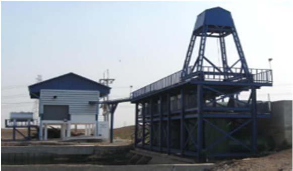

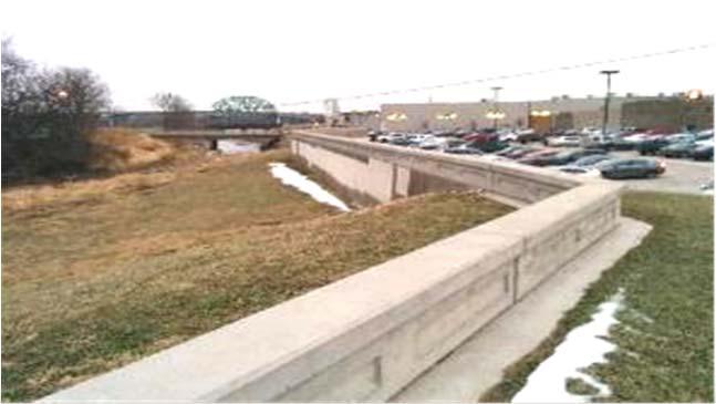
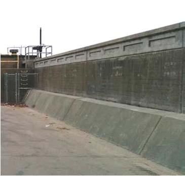
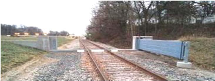
26 Examples of Hard Fixes Source: FEMA 26


27 Examples of Soft Fixes Source: California Department of Water Resources Source: University of Iowa 27
28 Reviewing Insurance Requirements and Options Policies Traditional Insurance Global Property Policy National Flood Insurance Program (NFIP) 28

29 Development of National Flood Insurance Program (NFIP) National Flood Insurance Program Administered Directly by FEMA Enables property owners to purchase flood insurance as an alternative to federal disaster assistance Communities must formally agree to regulate the use of their flood-prone lands Communities adopts certain NFIP-FEMA codes and ordinances Once adopted; FEMA will make flood insurance available to the community. FEMA identifies these flood hazard areas on maps and provides these maps to communities for carrying out their responsibilities 29
 per FEMA Maps Homes and buildings in high-risk flood areas with mortgages from federally regulated or insured lenders are required to")
30 National Flood Insurance Policy When is a NFIP mandatory? Residents of High-Risk Areas- Special Flood Hazard Area (SFHA) per FEMA Maps Homes and buildings in high-risk flood areas with mortgages from federally regulated or insured lenders are required to have NFIP flood insurance. Special Flood Hazard Area (SFHA) The area (also known as a 100 year Flood Zone) where the National Flood Insurance Program's (NFIP's) floodplain management regulations must be enforced and mandated flood insurance is required. The Most Common SFHA includes Zones A, AE, VE and V 30

31 Preferred Risk Policy (PRP) PRP is available to properties in Moderate to Low Risk Flood Zones Residents of Moderate-to-Low Risk Areas per FEMA Maps Homes and businesses located in moderate-to-low risk areas that have mortgages from federally regulated or insured lenders are typically not required to have flood insurance. A lender can require flood insurance, even if it is not federally required Moderate risk includes zones B and X-Shaded Zones Low risk includes zones C and X-Unshaded 31

32 Residential Condominium Building Association Policy The Residential Condominium Building Association Policy Form is issued to residential condominium associations on behalf of association and unit owners. Includes Mixed Use buildings where 75% of floor area is designated as Residential Not Placing the correct coverage often leads to a large gap in coverage 32
33 Policy Limits NFIP Insurance Policy Coverage Available Under The NFIP (Table Applies to PRP as well) Building Limits Basic Limits Additional Limits Total Limits Single Family $60,000 $190,000 $250, Family $60,000 $190,000 $250,000 Other Residential $175,000 $75,000 $250,000 Non Residential $175,000 $325,000 $500,000 Contents Basic Limits Additional Limits Total Limits Residential $25,000 $75,000 $100,000 Non Residential $150,000 $350,000 $500,000 33
34 Residential Condominium Building Association Policy Limits Maximum limit is equal to $250,000 x Number of Units. If the value of each unit is valued at less the than $250,000, then the maximum limit would be the actual replacement cost value of unit x number of units. Only contents owned by the association are eligible for coverage. 34

35 Lack of Compliance Delay in Financial Closings Refinance/Sale of a property Lenders cannot facilitate a closing without a NFIP secured Evidence of Coverage consists of: Providing a NFIP Declaration Page Applications Summary Proving a bound policy Lenders are subject to strict fines and penalties should they close knowing the property is located within a SFHA Post closing: If NFIP is NOT renewed; Lender may force place NFIP coverage at the full expense of the property owner 35
36 Letters of Map Change Letter of Map Change (LOMC) is a general term used to refer to the several types of revisions and amendments to FEMA maps that can be accomplished by letter. They include: Letter of Map Amendment (LOMA) Letter of Map Revision (LOMR) and Letter of Map Revision based on Fill (LOMR-F) 36
37 Opportunities for a Letter of Map Change Property has been incorrectly mapped as being in the floodplain, but is actually on natural high ground above the base flood elevation (Letter of Map Amendment (LOMA) When the floodplain has been elevated above the Base Flood Elevation by placement of fill. (LOMR-F) The implementation of physical measures that affect the hydraulic characteristics of a flooding source resulting in the modification of the existing regulatory floodway (Letter of Map Revision (LOMR) 37
38 Create a formidable team-the NFIP Team! Engineer who is specialized in Elevation Certificate specific to NFIP Insurance Broker/Insurance Carrier Placing NFIP is their primary business Readily Provides Engineer Contact(s) across your portfolio Ability to place NFIP quickly and upon payment, can provide Declaration Page showing proof of coverage immediately 38
 Mapping Program (Timing is critical) Immediately provides FEMA SFHA Designation Plan quickly and accordingly Instruct your internal")
39 Create a formidable team-the NFIP Team! (Continued) Mapping Program (Timing is critical) Immediately provides FEMA SFHA Designation Plan quickly and accordingly Instruct your internal and external teams with confidence Communicate Findings to Internal Team Finance Closings New Construction 39
 Apply for a Letter of Map Change LOMC After construction Very Costly Time Consuming Federally mandated to continue to purchase NFIP until LOMC is")
40 New Construction Design and Construction Plans Know the SFHA FEMA Designation Modify plans to move the property out of the SFHA Professional Consultants (through the local community) Apply for a Letter of Map Change LOMC After construction Very Costly Time Consuming Federally mandated to continue to purchase NFIP until LOMC is approved 40
41 Additional Questions? Greg Bates Managing Consultant Global Risk Consultants (770) Frank Francone Manager: Insurance & Risk Services General Growth Properties (312)
FREQUENTLY ASKED QUESTION ABOUT FLOODPLAINS Michigan Department of Environmental Quality
 FREQUENTLY ASKED QUESTION ABOUT FLOODPLAINS Michigan Department of Environmental Quality WHAT IS A FLOOD? The National Flood Insurance Program defines a flood as a general and temporary condition of partial
COLLIER COUNTY FLOODPLAIN MANAGEMENT
 COLLIER COUNTY FLOODPLAIN MANAGEMENT FREQUENTLY ASKED QUESTIONS The following information is based on common questions from the public. If you have a specific question or need further information, please
Questions about the National Flood Insurance Program
 Questions about the National Flood Insurance Program Federal Emergency Management Agency (FEMA) Questions and Answers What is the National Flood Insurance Program (NFIP)? The NFIP is a Federal program
FLOODPLAIN FAQ s. Last Update: June 2017
 FLOODPLAIN FAQ s Last Update: June 2017 What does FEMA stand for? Federal Emergency Management Agency - the operation of FEMA is to lead America to prepare for, prevent, respond to, and recover from disasters.
RiskTopics. Guide to flood emergency response plans September 2017
 RiskTopics Guide to flood emergency response plans September 2017 While floods are a leading cause of property loss, a business owner can take actions to mitigate and even help prevent damage and costly
JAXGIS FEMA Flood Hazard Mapping -- Frequently Asked Questions
 Flood Hazard Zone Designations Summary Zones starting with the letter 'A' (for instance, Zone A, Zone AE, Zone AH, Zone AO) denote a Special Flood Hazard Area, which can also be thought of as the 100-year
Floodplain Management 101. Mississippi Emergency Management Agency Floodplain Management Bureau
 Floodplain Management 101 Mississippi Emergency Management Agency Floodplain Management Bureau Stafford Act The Stafford Disaster Relief and Emergency Assistance Act (Stafford Act) (Public Law 100-707)
History of Floodplain Management in Ascension Parish
 History of Floodplain Management in Ascension Parish presented by: Kara Moree Floodplain Coordinator February 6, 2012 Floodplain 101 Floodplain 101 Base or 1% Flood: A flood having a 1% chance of being
NFIP Overview Elevation Certificate Flood Insurance Rate Maps. By: Maureen O Shea, AICP, CFM State NFIP Coordinator
 NFIP Overview Elevation Certificate Flood Insurance Rate Maps By: Maureen O Shea, AICP, CFM State NFIP Coordinator Example of a flood failure Example of a flood failure Purposes of the NFIP Identify &
NFIP Mapping Issues. Wendy Lathrop, PLS, CFM. Cadastral Consulting, LLC
 NFIP Mapping Issues Cadastral Consulting, LLC NFIP Basic Objectives: Reduce the exposure to flood damages through the use of minimum standards for the placement and design of structures located in flood
Key Fundamentals of Flood Insurance in the NFIP!
 a Welcome to Key Fundamentals of Flood Insurance in the NFIP! A Before and After approach for Housing Counselors Presented by: 1 Before the Flood Presenter Melanie Graham After the Flood Presenter Erin
The Power of Water: How to Prepare and Protect Your Business from Floods
 Hanover Risk Solutions The Power of Water: How to Prepare and Protect Your Business from Floods Each year, the United States suffers hundreds of millions, or even several billions, of dollars in flood
210 W Canal Dr Palm Harbor, FL 34684
 Flood Analysis Memo Property Address In Partnership with: ** This property is within a high risk flood zone ** BFE = 6 ft This property is located in the FEMA designated high-risk zone, Zone AE - an area
NFIP Program Basics. KAMM Regional Training
 NFIP Program Basics KAMM Regional Training Floodplain 101 Homeowners insurance does not cover flood damage Approximately 25,000 flood insurance policies in KY According to BW12 analysis, approximately
REAL ESTATE FLOOD DISCLOSURE PROGRAM & FLOOD MAP INFORMATION SERVICES
 REAL ESTATE FLOOD DISCLOSURE PROGRAM & FLOOD MAP INFORMATION SERVICES Lisa Foster, CFM, Floodplain Coordinator ldfoster@pinellascounty.org January 26, 2018 Why are you here? Save your clients money on
Repetitive Loss Area Revisit # 6 Walter Road Area Jefferson Parish
 Repetitive Loss Area Revisit # 6 Walter Road Area Jefferson Parish www.floodhelp.uno.edu Supported by FEMA Acknowledgement The compilation if this report was managed by Erin Patton, CFM, a UNO-CHART Research
Flood Insurance for Local Officials and Floodplain Managers. What Every Community Official Needs to Know About Flood Insurance
 Flood Insurance for Local Officials and Floodplain Managers What Every Community Official Needs to Know About Flood Insurance Illinois Association for Floodplain and Stormwater Management 2011 Annual Conference
COASTALRISK. FLOODANDNATURALHAZARDRISKASSESSMENT Commercial Mayport Naval Station, Jacksonville, FL September 7, 2018
 COASTALRISK FLOODANDNATURALHAZARDRISKASSESSMENT Commercial September 7, 2018 THISREPORTISPROVIDEDSUBJECTTOTHECOASTALRISKCONSULTING,LLC.TERMSANDCONDITIONSOFUSE,WHICHIS AVAILABLEATWWW.COASTALRISKCONSULTING.COM.THISANALYSISISFURNISHED
Enough about me! Topics Covered
 About Me Worked in land surveying since 1997 Employed by the City of Orlando since 2006 City of Orlando City Surveyor since February 2015 Certified Floodplain Manager since 2015 Florida Licensed Surveyor,
Door County Floodplain Program Informational Meeting
 Door County Floodplain Program Informational Meeting Door County Land Use Services Department Wisconsin Department of Natural Resources January 15, 2018 Floodplain = Land affected by flood event with a
Federal Emergency Management Agency
 Page 1 of 3 COMMUNITY AND MAP PANEL INFORMATION COMMUNITY CITY OF MARGATE CITY, ATLANTIC COUNTY, NEW JERSEY LEGAL PROPERTY DESCRIPTION A parcel of land, as described in Deed recorded in Book 4826, page
10526 Bermuda Isle Dr. Tampa, FL 33647
 Flood Analysis Memo Property Address In Partnership with: ** This property is NOT within a high-risk flood zone ** This property is located in a FEMA low-risk zone designated as Zone X - an area of minimal
REAL ESTATE FLOOD DISCLOSURE PROGRAM & FLOOD MAP INFORMATION SERVICES
 REAL ESTATE FLOOD DISCLOSURE PROGRAM & FLOOD MAP INFORMATION SERVICES Lisa Foster, CFM, Floodplain Coordinator ldfoster@pinellascounty.org January 26, 2018 Why are you here? Save your clients money on
SECTION 9: MAPS AND DATA
 SECTION 9: MAPS AND DATA Contents 9.1. NFIP Maps and Data... 9-2 9.1.1. Adopting and enforcing NFIP floodplain maps and data... 9-2 9.1.2. Adopting and enforcing more restrictive data... 9-2 9.1.3. Annexations...
10526 Bermuda Isle Dr. Tampa, FL 33647
 Flood Analysis Memo Property Address 10526 Bermuda Isle Dr. In Partnership with: ** This property is NOT within a high-risk flood zone ** 10526 Bermuda Isle Dr. BFE = 35 ft This property is located in
YOLO COUNTY FLOODPLAIN MANAGEMENT PROGRAM
 YOLO COUNTY FLOODPLAIN MANAGEMENT PROGRAM Answers to Commonly Asked Questions and A Guide for Residential Construction Within Special Flood Hazard Areas The automatic entry and exit of flood water); Or
Abington Township Public Meeting
 Abington Township Public Meeting Flood Insurance Rate Map Update March 23, 2016 1 Meeting Agenda and Format Provide residents/property owners of Abington Township with information about the map update,
National Flood Insurance Program (NFIP) for Real Estate Professionals
 for Real Estate Professionals") National Flood Insurance Program (NFIP) for Real Estate Professionals 1 Joshua Oyer, CFM Outreach Specialist NFIP State Coordinator s Office at the Texas Water Development Board 2 Outline Introduction
National Flood Insurance Program (NFIP) for Real Estate Professionals 1 Joshua Oyer, CFM Outreach Specialist NFIP State Coordinator s Office at the Texas Water Development Board 2 Outline Introduction
DES MOINES CITY OF TWO RIVERS. Flooding Risk & Impact to Development
 DES MOINES CITY OF TWO RIVERS Flooding Risk & Impact to Development River System Des Moines Flood Protection Des Moines Flood Protection cont. Infrastructure Over 24 miles of levees 21stormwater pump stations
Floodplain Management Annual Conference Atlanta, Georgia April 2017
 Floodplain Management 2017 Annual Conference Atlanta, Georgia April 2017 Floodplain Mapping and Flood Zones Zone Deisgnations: Zone A: No base flood elevations have been determined it is an approximated
Flood Analysis Memo. 629 Orangewood Dr. Dunedin, FL BFE = 21 ft
 Flood Analysis Memo Property Address 629 Orangewood Dr. In Partnership with: ** This property is NOT within a high-risk flood zone ** 629 Orangewood Dr. BFE = 21 ft This property is located in the FEMA
Durham County Preliminary Flood Hazard Data Public Meeting. July 28, 2016
 Durham County Preliminary Flood Hazard Data Public Meeting July 28, 2016 Why Are We Here New flood hazard data has been released as Preliminary for Durham County Statutory Due Process for review/comments
FLOOD INSURANCE. Most mortgage lenders require flood insurance for
 FLOOD INSURANCE Anywhere it rains, it can flood. A flood is a general and temporary condition where two or more acres of normally dry land or two or more properties are inundated by water. Many conditions
Taylor County, Florida Community Coordination and Outreach (CCO) Meeting
 Meeting") Taylor County, Florida Community Coordination and Outreach (CCO) Meeting Suwannee River Water Management District April 26, 2017 11:00AM to 12:00PM Taylor County Administration Building, 201 E. Green Street,
Taylor County, Florida Community Coordination and Outreach (CCO) Meeting Suwannee River Water Management District April 26, 2017 11:00AM to 12:00PM Taylor County Administration Building, 201 E. Green Street,
CONTRA COSTA COUNTY FLOODPLAIN MANAGEMENT PROGRAM
 CONTRA COSTA COUNTY FLOODPLAIN MANAGEMENT PROGRAM Answers to Commonly Asked Questions and A Guide for Residential Construction Within Special Flood Hazard Areas Revised February 2015 Introduction Ninety
Preliminary DFIRM Community Coordination (PDCC) Meeting Gilchrist & Levy Counties, FL. April 30, 2015
 Meeting Gilchrist & Levy Counties, FL. April 30, 2015") Preliminary DFIRM Community Coordination (PDCC) Meeting Gilchrist & Levy Counties, FL April 30, 2015 Agenda 1. Introductions 2. Study Process and Timeline 3. Overview of Preliminary Products 4. Overview
Preliminary DFIRM Community Coordination (PDCC) Meeting Gilchrist & Levy Counties, FL April 30, 2015 Agenda 1. Introductions 2. Study Process and Timeline 3. Overview of Preliminary Products 4. Overview
Introduction. How severe have floods been in the past?
 Introduction The Ascension Parish Council is dedicated to minimizing the loss of life and property that is associated with flooding events. Education and prevention are valuable and proven tools that help
MT-1 Basics: A Comprehensive Overview of LOMAs and Discussion of Common Application Setbacks
 MT-1 Basics: A Comprehensive Overview of LOMAs and Discussion of Common Application Setbacks Introduction: Terminology MT-1s vs. MT-2s LOMAs vs. LOMRs What is a LOMC? Letters of Map Change (LOMCs) MT-1s
July 31, 2017 NFIP Flood Map Open House Flood Maps 101 Flood Mapping acronyms History of the NFIP Flood Mapping Updates Flood Insurance Fairhope,
 July 31, 2017 NFIP Flood Map Open House Flood Maps 101 Flood Mapping acronyms History of the NFIP Flood Mapping Updates Flood Insurance Fairhope, Alabama Flood Maps Fairhope Permitting Jurisdiction Coastal
Nassau County, Florida Consultation Coordination Officer (CCO) Meeting. February 24, 2016 Fernandina Beach, Florida
 Meeting. February 24, 2016 Fernandina Beach, Florida") Nassau County, Florida Consultation Coordination Officer (CCO) Meeting February 24, 2016 Fernandina Beach, Florida Agenda Introductions Coastal Study Update Study Process and Timeline Flood Insurance Implications
Nassau County, Florida Consultation Coordination Officer (CCO) Meeting February 24, 2016 Fernandina Beach, Florida Agenda Introductions Coastal Study Update Study Process and Timeline Flood Insurance Implications
Using GISWeb to Determine Your Property s Flood Zone
 Using GISWeb to Determine Your Property s Flood Zone 1. In a new browser window, go to http://www.co.santacruz.ca.us/departments/geographicinformationsystemsgis.aspx 2. Click on GISWeb - GIS Mapping Application
Flood Insurance THE TOPIC OCTOBER 2012
 Flood Insurance THE TOPIC OCTOBER 2012 Because of frequent flooding of the Mississippi River during the 1960s and the rising cost of taxpayer funded disaster relief for flood victims, in 1968 Congress
Upper Joachim Creek Public Survey on Potential Flood Risk Reduction
 Upper Joachim Creek Public Survey on Potential Flood Risk Reduction This survey is intended to help the interagency planning committee to receive public feedback on specific flood risk reduction techniques,
Hazard Mitigation Planning
 Hazard Mitigation Planning Mitigation In order to develop an effective mitigation plan for your facility, residents and staff, one must understand several factors. The first factor is geography. Is your
National Institute of Building Sciences
 National Institute of Building Sciences Provider Number: G168 Improving the Flood Resistance of Buildings and Mitigation Techniques WE3B Peter Spanos, P.E., CFM, LEED AP (Gale Associates, Inc.) Stuart
Article 23-6 FLOODPLAIN DISTRICT
 AMENDING THE CODE OF THE CITY OF PITTSFIELD CHAPTER 23, ZONING ORDINANCE SECTION I That the Code of the City of Pittsfield, Chapter 23, Article 23-6 Floodplain District, shall be replaced with the following:
Deciphering Flood: A Familiar and Misunderstood Risk
 Special Report Deciphering Flood: A Familiar and Misunderstood Risk May 2017 Deciphering Flood: A Familiar and Misunderstood Risk Among natural disasters, floods are the most common, 1 but from an insurance
SUPERHERO!!! Elevation Certificate. You are about to go from SURVEYOR 2/18/2019
 Karol L. Grove Licensed Professional Surveyor Certified Floodplain Manager Elevation Certificate No longer the Animal it used to be When are they needed??? You are about to go from SURVEYOR to SUPERHERO!!!
SECTION 5 FLOOD DISASTER PROTECTION ACT
 2018 CUNA MORTGAGE LENDING REGULATIONS 5-1 Section 5 Flood Disaster Protection Act Background The Flood Disaster Protection Act (FDPA) of 1973 and the National Flood Insurance Reform Act (NFIRA) of 1994
a) Ensure public safety through reducing the threats to life and personal injury.
 Ensure public safety through reducing the threats to life and personal injury.") SECTION VII: FLOODPLAIN DISTRICT 7-1 Statement Of Purpose The purposes of the Floodplain District are to: a) Ensure public safety through reducing the threats to life and personal injury. b) Eliminate
SECTION VII: FLOODPLAIN DISTRICT 7-1 Statement Of Purpose The purposes of the Floodplain District are to: a) Ensure public safety through reducing the threats to life and personal injury. b) Eliminate
Vocabulary of Flood Risk Management Terms
 USACE INSTITUTE FOR WATER RESOURCES Vocabulary of Flood Risk Management Terms Appendix A Leonard Shabman, Paul Scodari, Douglas Woolley, and Carolyn Kousky May 2014 2014-R-02 This is an appendix to: L.
Floodplain Development Permits A Technical Guidance Document
 Floodplain Development Permits A Technical Guidance Document To Prevent Loss of Life, Reduce Property Damage and to Protect and Enhance the Natural and Beneficial Functions of Floodplains Iredell County
Federal Emergency Management Agency
 Page 1 of 4 Issue Date: October 2, 2017 Effective Date: October 2, 2017 Case No.: 17-09-2731P LOMR-APP Federal Emergency Management Agency Washington, D.C. 20472 LETTER OF MAP REVISION DETERMINATION DOCUMENT
Huntington Beach LCPA 1-16 (Sunset Beach Specific Plan) DRAFT Hazard Analysis Sug Mod Working Document/Not for general circulation.
 DRAFT Hazard Analysis Sug Mod Working Document/Not for general circulation.") LCPA 1-16 (Sunset Beach Specific Plan) DRAFT Hazard Analysis Sug Mod Working Document/Not for general circulation. 3.3 Regulations (page 34) 3.3.9 (page 60) Add new Section 3.3.9 below after Flood Plain
LCPA 1-16 (Sunset Beach Specific Plan) DRAFT Hazard Analysis Sug Mod Working Document/Not for general circulation. 3.3 Regulations (page 34) 3.3.9 (page 60) Add new Section 3.3.9 below after Flood Plain
Commonwealth Schools of Insurance, Inc.
 Commonwealth Schools of Insurance P.O. Box 22414, Louisville, KY 40252-0414 502.425.5987 FAX 502.429.0755 E-mail: info@commonwealthschools.com INSTRUCTIONS TO COMPLETE THE CONTINUING EDUCATION COURSE Thank
Community Rating System. National Flood Insurance Program
 National Flood Insurance Program Community Rating System A Local Official s Guide to Saving Lives Preventing Property Damage Reducing the Cost of Flood Insurance FEMA B-573 / May 2015 How the Community
LOCAL OFFICIALS MEETING Lake Wausau Physical Map Revision MARATHON COUNTY, WISCONSIN FEBRUARY 9, 2017
 LOCAL OFFICIALS MEETING Lake Wausau Physical Map Revision MARATHON COUNTY, WISCONSIN FEBRUARY 9, 2017 Welcome & Introduction Michelle Staff Floodplain Management Policy Coordinator, WDNR Michelle.Staff@Wisconsin.gov
Delaware River Basin Commission s Role in Flood Loss Reduction Efforts
 Delaware River Basin Commission s Role in Flood Loss Reduction Efforts There is a strong need to reduce flood vulnerability and damages in the Delaware River Basin. This paper presents the ongoing role
ADVISORY BASE FLOOD ELEVATIONS (ABFEs)
") The Department of Homeland Security s Federal Emergency Management Agency is committed to helping communities that were impacted by Hurricanes Katrina and Rita rebuild safer and stronger. Following catastrophic
The Department of Homeland Security s Federal Emergency Management Agency is committed to helping communities that were impacted by Hurricanes Katrina and Rita rebuild safer and stronger. Following catastrophic
Public Meeting Impact of Hurricane Irma on Central Beach
 Public Meeting Impact of Hurricane Irma on Central Beach CITY OF NEW SMYRNA BEACH October 11, 2017 at 6:00 pm Presentation Outline Hurricane Irma Impacts Flooding Caused by Hurricane Irma Original Goals
The National Flood Insurance Program and Flood Insurance Rate Map for San Francisco. Presentation at Treasure Island Community Meeting
 The National Flood Insurance Program and Flood Insurance Rate Map for San Francisco Presentation at Treasure Island Community Meeting October 17, 2007 1 National Flood Insurance Program (NFIP) Overview
Canada s exposure to flood risk. Who is affected, where are they located, and what is at stake
 Canada s exposure to flood risk Who is affected, where are they located, and what is at stake Why a flood model for Canada? Catastrophic losses Insurance industry Federal government Average industry CAT
Flood Risk Management and Nonstructural Flood Risk Adaptive Measures
 Flood Risk Management and Nonstructural Flood Risk Adaptive Measures Randall Behm, P.E., CFM USACE-Omaha District Chair, National Nonstructural Flood Proofing Committee US Army Corps of Engineers BUILDING
Workshop Summary: Adaptation to Sea Level Rise Best Practices Village of Key Biscayne. Presented by: AECOM May 26, 2017
 Workshop Summary: Adaptation to Sea Level Rise Best Practices Village of Key Biscayne Presented by: AECOM May 26, 2017 Report Prepared June 23, 2017 Chapter 1 Introduction...1 Chapter 2 Flood Hazards...2
Herkimer County, New York Flood Hazard Mapping Status Report for Property Owners
 Herkimer County, New York Flood Hazard Mapping Status Report for Property Owners Herkimer County, New York Flood Hazard Mapping Status Report for Property Owners FLOOD INSURANCE Who Should Purchase Flood
Bullitt County, Kentucky Preliminary DFIRM Community Open House. October 8, 2014 Shepherdsville, Kentucky
 Bullitt County, Kentucky Preliminary DFIRM Community Open House October 8, 2014 Shepherdsville, Kentucky Meeting Agenda Introductions Overview of Preliminary DFIRMs Overview of Map Appeal Process Questions
THE FEDERAL EMERGENCY MANAGEMENT AGENCY. Letters of Map Change Kristen Martinenza, P.E., CFM FEMA Region IV
 THE FEDERAL EMERGENCY MANAGEMENT AGENCY Letters of Map Change Presented by: Kristen Martinenza, P.E., CFM FEMA Region IV 1 NATIONAL FLOOD INSURANCE ACT OF 1968 At the start of the program, there was not
Erie County Flood Risk Review Meeting. January 18, 2018
 Erie County Flood Risk Review Meeting January 18, 2018 Agenda The value of updated flood maps for your community Review updated flood-risk data and important next steps in the Risk MAP process Increasing
National Flood Insurance Program Making Sense of April 2019 Changes
 National Flood Insurance Program Making Sense of April 2019 Changes Foreword The National Flood Insurance Program (NFIP) provides an important means for property owners to protect themselves financially
Pinellas County Flood Map Information Service & Real Estate Disclosure Program Training January 26, 2017 COMMON FLOODPLAIN ACRONYMS
 FEMA ASFPM BFE CAV Pinellas County Flood Map Information Service & Real Estate Disclosure Program Training COMMON FLOODPLAIN ACRONYMS Federal Emergency Management Agency Association of State Floodplain
Flood Insurance Information for Prospective Buyers
 Flood Insurance Information for Prospective Buyers 25. Who may purchase a flood insurance policy? NFIP coverage is available to all owners of eligible property (a building and/or its contents) located
Sea Level Rise and the NFIP
 Cheryl A Johnson, PE, CFM, PMP March 26, 2014 http://www.globalchange.gov/ Sea-level rise and the likely increase in hurricane intensity and associated storm surge will be among the most serious consequences
Pre-Development Floodplain Application
 Pre-Development Floodplain Application The Department of Planning, at the recommendation of FEMA, is now requiring completion of a Pre- Development Floodplain Application for all properties in the regulated
YAVAPAI COUNTY FLOOD CONTROL DISTRICT STAKEHOLDER WORKSHOP. March 30 th & 31 st, 2015
 YAVAPAI COUNTY FLOOD CONTROL DISTRICT STAKEHOLDER WORKSHOP March 30 th & 31 st, 2015 1 Floods Happen In Yavapai County September 1983 Northwest Prescott Area: - Willow Creek - Bottleneck Wash - Granite
Things You Should Know About Flood Protection
 Things You Should Know About Flood Protection Because the is located in a unique geographical area; it is particularly susceptible to flooding from major rain events and storm surge. The City is surrounded
Requirements for Construction on Properties in the Special Flood Hazard Area (SFHA)
") Requirements for Construction on Properties in the Special Flood Hazard Area (SFHA) Rev 010915 The website for the IDNR to request the EFARA (Electronic Floodplain Analysis/Regulatory Assessment is found
Requirements for Construction on Properties in the Special Flood Hazard Area (SFHA) Rev 010915 The website for the IDNR to request the EFARA (Electronic Floodplain Analysis/Regulatory Assessment is found
Frequently Asked Questions and Answers Concerning Flood Insurance
 Frequently Asked Questions and Answers Concerning Flood Insurance Sources Used: (1) www.floodsmart.gov (2) National Flood Insurance Program, Answers to Questions about the NFIP, FEMA F-084/ March 2011.
Community Resilience & NFIP s Community Rating system
 Community Resilience & NFIP s Community Rating system Ajita Atreya Wharton Risk Management and Decision Processes Center University of Pennsylvania National Association of Counties (NACo) Session on Risk
BUTTS COUNTY, GEORGIA AND INCORPORATED AREAS
 BUTTS COUNTY, GEORGIA AND INCORPORATED AREAS Butts County Community Name Community Number BUTTS COUNTY (UNICORPORATED AREAS) 130518 FLOVILLA, CITY OF 130283 JACKSON, CITY OF 130222 JENKINSBURG, TOWN OF
Technical Memorandum 3.4 E Avenue NW Watershed Drainage Study. Appendix E Floodplain Impacts and Implications Memo
 Technical Memorandum 3.4 E Avenue NW Watershed Drainage Study Appendix E Floodplain Impacts and Implications Memo September 8, 2017 City of Cedar Rapids E Avenue Watershed Drainage Study Memo Date: Tuesday,
Duval County, Florida Consultation Coordination Officer (CCO) Meeting. January 25, 2017 Jacksonville, Florida
 Meeting. January 25, 2017 Jacksonville, Florida") Duval County, Florida Consultation Coordination Officer (CCO) Meeting January 25, 2017 Jacksonville, Florida Agenda Introductions Coastal Study Update Study Process and Timeline Flood Insurance Implications
Duval County, Florida Consultation Coordination Officer (CCO) Meeting January 25, 2017 Jacksonville, Florida Agenda Introductions Coastal Study Update Study Process and Timeline Flood Insurance Implications
Federal Emergency Management Agency
 Page 1 of 5 Issue Date: June 21, 2013 Follows Conditional Case No.: 04-06-A148R DETERMINATION DOCUMENT COMMUNITY COMMUNITY AND REVISION INFORMATION City of Irving Dallas County Texas FILL PROJECT DESCRIPTION
Mistakes on Elevation Certificates
 Mistakes on Elevation Certificates What is the Base Flood Elevation (BFE) & how do you determine it? FIRM Map Panel? Flood Insurance Study? o Profile Sheet o Floodway Data Chart o Stillwater Chart Community
JOINT STUDY ON FLOOD ELEVATIONS AND BUILDING HEIGHT REQUIREMENTS PURSUANT TO 2015 N.C. SESS. LAW 286. Presented by:
 JOINT STUDY ON FLOOD ELEVATIONS AND BUILDING HEIGHT REQUIREMENTS PURSUANT TO 2015 N.C. SESS. LAW 286 Presented by: Dan H. Tingen Chairman of the North Carolina Building Code Council Rick McIntyre North
N.C. Floodplain Mapping Program
 N.C. Floodplain Mapping Program Current Status and Update April 23, 2018 NCFMP Program Objectives Purpose: Develop, Maintain, and Disseminate current, accurate, digital flood hazard data for all of NC,
Step 3: Adaptation Planning & Design. Logan Airport
 Step 3: Adaptation Planning & Design Logan Airport Terminal A Satellite Doors to Harborside Substation CAT. 3 HURRICANE (MHHW) FLOOD EL. = 20.75 CAT. 2 HURRICANE (HAT) EST. FLOOD EL. = 18.42 CAT. 2 HURRICANE
The AIR Inland Flood Model for Great Britian
 The AIR Inland Flood Model for Great Britian The year 212 was the UK s second wettest since recordkeeping began only 6.6 mm shy of the record set in 2. In 27, the UK experienced its wettest summer, which
F E M A Mapping Changes. FEMA Mapping Changes. National Flood Insurance Program
 FEMA Mapping Changes National Flood Insurance Program 1 Welcome to FEMA Mapping Changes! We will get started in a few minutes. Meanwhile, let s perform a warm up exercise. 2 1 Training Agenda Section 1-
UHM Insurance Requirements (Hazard, Condominium, H0-6 and Flood)
") This Insurance Guide is provided by Union Home Mortgage Corp. ( UHM ), having its principal place of business at 8241 Dow Circle West, Strongsville, OH 44136. UHM publishes this via its secured website
This Insurance Guide is provided by Union Home Mortgage Corp. ( UHM ), having its principal place of business at 8241 Dow Circle West, Strongsville, OH 44136. UHM publishes this via its secured website
AMENDMENTS TO CHAPTER 50: FLOODPLAIN DEVELOPMENT
 AMENDMENTS TO CHAPTER 50: FLOODPLAIN DEVELOPMENT PART I: 2018 FLOOD MAP IMPLEMENTATION PART II: STRATEGIES TO IMPROVE THE CITY S COMMUNITY RATING SYSTEM SCORE NATIONAL FLOOD INSURANCE PROGRAM (NFIP) CREATED
SECTION V THE LOCAL MITIGATION STRATEGY BLUEPRINT
 SECTION V THE LOCAL MITIGATION STRATEGY BLUEPRINT A. GUIDING MITIGATION PRINCIPLES The Local Mitigation Strategy (LMS) is Hillsborough County s program developed to reduce or eliminate all forms of losses
Chapter 7 Appendix B: National Flood Insurance Program Summary for Kaua'i County, 2015 Update
 Chapter 7 Appendix B: National Flood Insurance Program Summary for Kaua'i County, 2015 Update Topic Considerations Description INSURANCE SUMMARY STAFF RESOURCES How many NFIP policies are in Kaua i County?
Volusia County Floodplain Management Plan 2012
 Volusia County Floodplain Management Plan 2012 Introduction The National Flood Insurance Program (NFIP) provides federally supported flood insurance in communities that regulate development in floodplains.
If you have any questions or concerns please give us a call at , or Walter Jenkins at (ext 300).
.") FLORIDA ZONE SERVICES Flood Insurance and Zone Consulting 461 SE 3 rd Terrace Pompano Beach, FL 33060 Phone 954-290-7420 bspencer@florida-floodzone.com March 6, 2014 Dear Pebblebrook II Homeowner: We informing
FLORIDA ZONE SERVICES Flood Insurance and Zone Consulting 461 SE 3 rd Terrace Pompano Beach, FL 33060 Phone 954-290-7420 bspencer@florida-floodzone.com March 6, 2014 Dear Pebblebrook II Homeowner: We informing
P art B 4 NATURAL HAZARDS. Natural Hazards ISSUE 1. River Flooding
 4 NATURAL HAZARDS ISSUE 1 River Flooding A large part of the plains within the Timaru District is subject to some degree of flooding risk. At least part of all of the main settlements in the District and
REAL ESTATE FLOOD DISCLOSURE PROGRAM & FLOOD MAP INFORMATION SERVICES
 REAL ESTATE FLOOD DISCLOSURE PROGRAM & FLOOD MAP INFORMATION SERVICES Agenda 10:30-12:00 Flood Disclosure Program 12:00-12:30 Lunch 12:30-1:30 Flood Map Service Center Lisa Foster, CFM, Floodplain Coordinator
This survey is expected to take approximately 20 minutes and must be completed in one session.
 State Flood Assessment Survey 1 Introduction Thank you for your willingness to participate in this online survey as part of the State Flood Assessment effort. This first step toward developing comprehensive
Using Non-Regulatory RiskMAP Products in Floodplain Management. Ferrin Affleck, PE, CFM, Water Resources Engineer Project Manager Atkins
 Using Non-Regulatory RiskMAP Products in Floodplain Management Ferrin Affleck, PE, CFM, Water Resources Engineer Project Manager Atkins 1 Goal of this Presentation Inform Peak interest Stimulate creativity
Chapter 6 - Floodplains
 Chapter 6 - Floodplains 6.1 Overview The goal of floodplain management is to reduce the potential risks to both existing and future developments, and infrastructure, in the 100-year floodplain. Over the
This survey is expected to take approximately 20 minutes and must be completed in one session.
 Introduction Thank you for your willingness to participate in this online survey as part of the State Flood Assessment effort. This first step toward developing comprehensive flood planning for Texas does