Urban Flooding in Illinois The Changing Face of Floods
|
|
|
- Susan Gaines
- 5 years ago
- Views:
Transcription

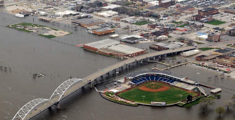
1 Urban Flooding in Illinois The Changing Face of Floods Chicago Albany Park Neighborhood June 2008 National Academies of Science Chicago, IL September 19, 2017


2 Welcome to Illinois Floods? Really?
.")

3 Illinois Where our Governors Make License Plates 1 st in the number of jailed Governors (5). 1 st in the number of indicted state officials (1,000+). 1st in poor fiscal policy the most broke state in the union. 1 st in the most underfunded pension program. 1 st in murders (765 in Chicago alone last year).

4


5 Declared Disasters The largest inland system of rivers, lakes, and streams in the entire nation!
. Local regulatory maps. Critical facilities.")
6 Going Above and Beyond in Illilnois Restrictive 0.1 floodway. Appropriate uses only. No buildings! Compensatory storage required (1 : 1.5). Cumulative Substantial damage regulations. Freeboard one foot minimum. Stormwater regulations (detention/retention). Local regulatory maps. Critical facilities. Countywide ordinances. Strict compliance - fines!


7 The feathers in our cap Illinois is ranked #1 in the nation for: 1. Overall % reduction of Rep Loss properties. 2. Fewest % of flood insurance claims on post-firm (newer) structures. 3. The most NFIP suspensions for compliance (75% of the nation s total)!

8 Our success is measured in silence..


9 Harriet Festing and Center for Neighborhood Technolgy

10


11 The Old Enemy. The New Enemy.


12 Urban Flood Awareness Act Effective August 3, 2014


13 Partners Listed in the Act Other State, regional, and local storm water management agencies, thought leaders, and interested parties as the Director of Natural Resources deems appropriate

14 Definition: Urban Flooding Working Definition: In a Built up area, not undeveloped or Ag land Repetitive, costly, and systematic Not tied to formal floodplains Root Causes: Wet soil Inadequate Infrastructure Overbank flooding Impervious surfaces Inadequate site drainage Climate uncertainty Podgorski, A. (2008) Sun Times

15 US Census Bureau = Definition: Urban >2,500 people & 1,000 people per sq. mi. Illinois = 7.1% Urban Area & 88% of pop. 12% of municipalities included Working Definition = Density requirement only Illinois = 7.8% Urban Area 91% of municipalities included Urban Areas of Illinois

16 Illinois Department of Insurance Data Collection Basement and sewer backup claims (past 7 years) Federal Emergency Management Agency Disaster Assistance National Flood Insurance claims Urban Flooding Survey 120 municipalities responded Urban Flooding Symposium Professional judgement Other data collection Stakeholder information

17 Sections of the Report Total Claims Past, Current, and Future Prevalence, cost, and trends Impacts of climate change Review technology to evaluate risk Effectiveness of Projects, Programs and Policies Strategies for Reducing Urban Flood Damages
18
19 Analysis of Flood Damage Claims In Illinois. 92% of flood damages now occur outside of the floodplain! Wow! Payments ($ Millions) $800 $700 $600 $500 $400 $300 $200 Private NFIP IA PA $100 Sewer backup vs Flood insurance $ NFIP losses are pocket change!


20 Sections of the Report Climate Change Past, Current, and Future Prevalence, cost, and trends Impacts of climate change Review technology to evaluate risk Effectiveness of Projects, Programs and Policies Strategies for Reducing Urban Flood Damages

21 National Climate Data Center Analyses of Flood-Causing Precipitation

22 Sections of the Report Review Technology Past, Current, and Future Prevalence, cost, and trends Impacts of climate change Review technology to evaluate risk Effectiveness of Projects, Programs and Policies Strategies for Reducing Urban Flood Damages

23 Sections of the Report Programs and Policies Past, Current, and Future Effectiveness of Projects, Programs and Policies Impact of county stormwater programs Evaluation of stormwater policies Consistency of criteria for state funding Strategies for Reducing Urban Flood Damages

24 Sections of the Report -Strategies Past, Current, and Future Effectiveness of Projects, Programs and Policies Strategies for Reducing Urban Flood Damages Strategies for flood insurance and basement backup insurance Strategies for NFIP and CRS Strategies to minimize damages
25 Flood Insurance vs Basement Coverage FLOOD COVERAGE BASEMENT COVERAGE Mostly NFIP coverage (some private sector) Triggered by a flood Overland flow 2 adjacent lots or 2 acres Structural and contents coverage sold separately Limited basement coverage Can t be cancelled Premiums don t increase based on claims history. Private sector coverage Sold as a rider on homeowner s policy Covers flood caused by stormwater or sewer backup. Sump failure usually included Usually fairly cheap Claims could increase premiums Read the small print


26 Sections of the Report - Strategies Past, Current, and Future Effectiveness of Projects, Programs and Policies Strategies for Reducing Urban Flood Damages Strategies for flood insurance and basement backup insurance Strategies for NFIP and CRS Strategies to minimize damages


27 Chicago Deep Tunnel Project

28 Top 10 Recommendations 1. Authority to generate stormwater fees. 2. Stormwater management authority. 3. Insurance agent education. 4. Update rainfall frequency distribution information. 5. Create a state model stormwater ordinance. 6. Continue funding data collection. 7. IDNR/IEPA should expand state revolving fund. 8. Urban flood awareness campaign. 9. Annual funding for repetitive flood loss in/out of floodplain. 10. Fund mitigation programs to better leverage Federal funds

29 ASFPM Urban Flood Risk Symposium Chicago February 2015 Local communitywide regulation is the most efficient way to address urban flooding. Mapping of urban flood areas is not feasible and should remain at a local level and not become an unfunded mandate.
30 Summary of Action Items 1. Encourage incentives to incorporate green infrastructure and low impact development at a state or local level. 2. Provide best practices to communicate urban flood risk to the public. 3. Support development of model storm water ordinance with design standards or best practices for evaluation of existing facilities, redevelopment that includes green infrastructure and maintenance issues. 4. Counties and non-home rule communities should be given the power to establish stormwater utility fees. 5. Support legislation to require flood risk communication when transferring property and in rental agreements. 6. Support community s assessment of stormwater utility programs with training and documentation of best practices. 7. Review grant funding opportunities to evaluate how to encourage and prioritize their use to support innovative practices or for planning and assessment efforts that result in stronger and more self-reliant communities.


31 Local Efforts Work. Trust! The Most effective strategy is the least scientific strategy

32 All The Best Communities: Take ownership! Don t rely on FEMA/State. Have a local champion. Increase outreach. It s not all about fancy products. Have strong regs and enforce them.strictly! Take advantage of programs and incentives. Make friends (and trust their friends).

33 A great View! Look at all that GREEN in Grafton! THANK YOU
Justification for Floodplain Regulatory Standards in Illinois
 Justification for Floodplain Regulatory Standards in Illinois Office of Water Resources Issue Paper April, 2015 Proactive Illinois floodplain and floodway regulatory standards have prevented billions of
Role of Disaster Insurance in Improving Resilience: An Expert Meeting The Resilient America Roundtable
 Role of Disaster Insurance in Improving Resilience: An Expert Meeting The Resilient America Roundtable National Academy of Science Washington, DC July 9, 2015 Roseville Demographics Primary population
Flood Hazards and Flood Risk, the Impact of a Changing Climate
 Flood Hazards and Flood Risk, the Impact of a Changing Climate Sally A. McConkey, P.E. CFM, D. WRE. Illinois State Water Survey June 14, 2017 Topics ISWS Coordinated Hazard Assessment and Mapping Program
Financing Floods in Chicago. Sephra Thomas. GIS for Water Resources C E 394K. Dr. David Maidment
 Financing Floods in Chicago Sephra Thomas GIS for Water Resources C E 394K Dr. David Maidment Fall 2018 Abstract The objective of this term paper is to study the hydrology and social vulnerability of Chicago,
SECTION 9: MAPS AND DATA
 SECTION 9: MAPS AND DATA Contents 9.1. NFIP Maps and Data... 9-2 9.1.1. Adopting and enforcing NFIP floodplain maps and data... 9-2 9.1.2. Adopting and enforcing more restrictive data... 9-2 9.1.3. Annexations...
Bucks County, PA Flood Risk Review Meeting. November 2014
 Bucks County, PA Flood Risk Review Meeting November 2014 Agenda for Today Risk MAP Program overview Overview of non-regulatory Flood Risk Products and datasets Discuss mitigation action Technical overview
FEMA FLOOD MAPS Public Works Department Stormwater Management Division March 6, 2018
 FEMA FLOOD MAPS Public Works Department Stormwater Management Division March 6, 2018 Presentation Overview FEMA National Flood Insurance Program (NFIP) FEMA Community Rating System (CRS) Flood Insurance
Upper Joachim Creek Public Survey on Potential Flood Risk Reduction
 Upper Joachim Creek Public Survey on Potential Flood Risk Reduction This survey is intended to help the interagency planning committee to receive public feedback on specific flood risk reduction techniques,
FREQUENTLY ASKED QUESTION ABOUT FLOODPLAINS Michigan Department of Environmental Quality
 FREQUENTLY ASKED QUESTION ABOUT FLOODPLAINS Michigan Department of Environmental Quality WHAT IS A FLOOD? The National Flood Insurance Program defines a flood as a general and temporary condition of partial
City of St. Augustine. Floodplain Management Higher Standards Information
 City of St. Augustine Floodplain Management Higher Standards Information There are different regulations that communities can use to help protect existing and future development and natural floodplain
Community Rating System. National Flood Insurance Program
 National Flood Insurance Program Community Rating System A Local Official s Guide to Saving Lives Preventing Property Damage Reducing the Cost of Flood Insurance FEMA B-573 / May 2015 How the Community
Flood Risk in the Schuylkill Watershed. Planning for Resilient Communities
 Flood Risk in the Schuylkill Watershed Planning for Resilient Communities Welcome to Our Poster Session! We are here to talk about: Flood Risk in the Schuylkill River Watershed Taking Action to Reduce
SECTION V THE LOCAL MITIGATION STRATEGY BLUEPRINT
 SECTION V THE LOCAL MITIGATION STRATEGY BLUEPRINT A. GUIDING MITIGATION PRINCIPLES The Local Mitigation Strategy (LMS) is Hillsborough County s program developed to reduce or eliminate all forms of losses
Repetitive Loss Area Revisit # 6 Walter Road Area Jefferson Parish
 Repetitive Loss Area Revisit # 6 Walter Road Area Jefferson Parish www.floodhelp.uno.edu Supported by FEMA Acknowledgement The compilation if this report was managed by Erin Patton, CFM, a UNO-CHART Research
APWA 2016 PWX 8/18/2016. A How to Guide to Funding Stormwater Projects for Small Cities/Rural Communities PWX Minneapolis August 29, 2016
 A How to Guide to Funding Stormwater Projects for Small Cities/Rural Communities. 2016 PWX Minneapolis August 29, 2016 PART 1 WHAT IS A STORM WATER UTILTY? 1 OVERVIEW Stormwater Utility Definition Authority
Crediting Adaptation Strategies through the National Flood Insurance Program s Community Rating System Coordinator s Manual
 Crediting Adaptation Strategies through the National Flood Insurance Program s Community Rating System Coordinator s Manual W. Thomas Hawkins, Adjunct Faculty, University of Florida, Levin College of Law
Planning Process---Requirement 201.6(b): An open public involvement process is essential to the development of an effective plan.
: An open public involvement process is essential to the development of an effective plan.") Section 3 Capability Identification Requirements Planning Process---Requirement 201.6(b): An open public involvement process is essential to the development of an effective plan. Documentation of the Planning
Section 3 Capability Identification Requirements Planning Process---Requirement 201.6(b): An open public involvement process is essential to the development of an effective plan. Documentation of the Planning
Welcome to a Silver Jackets Webinar
 Welcome to a Silver Jackets Webinar The CRS and Repetitive Loss Area Analysis (RLAA) For audio, Dial: 877 336-1839 Access code: 5884527 Security code: 4567 Visual 10.1 David A. Stroud, CFM Emergency &
STORMWATER MANAGEMENT FUND Department of Environmental Services
 Department of Environmental Services Mission: To implement a comprehensive stormwater management program that balances the following goals: 1) to reduce the potential for stormwater threats to public health,
HAZARD MITIGATION PLAN POINT OF CONTACT MUNICIPAL PROFILE
 HAZARD MITIGATION PLAN POINT OF CONTACT louise@windgap-pa.gov jeffreyyob@gmail.com MUNICIPAL PROFILE MUNICIPAL PARTICIPATION Compliance with the National Flood Insurance Program (NFIP) Identify source
ASFPM Partnerships for Statewide Mitigation Actions. Alicia Williams GIS and HMP Section Manager, Amec Foster Wheeler June 2016
 ASFPM Partnerships for Statewide Mitigation Actions Alicia Williams GIS and HMP Section Manager, Amec Foster Wheeler June 2016 Summary The Concept Leveraging Existing Data and Partnerships to reduce risk
Natural Hazards Mitigation Plan Kankakee County, Illinois Executive Summary
 1. Introduction Natural Hazards Mitigation Plan Kankakee County, Illinois Executive Summary Kankakee County is subject to natural hazards that threaten life, safety, health, and welfare and cause extensive
CAPABILITY ASSESSMENT
 SECTION 7 CAPABILITY ASSESSMENT This section of the Plan discusses the capability of the communities in the Smoky Mountain Region to implement hazard mitigation activities. It consists of the following
FLOODPLAIN MANAGEMENT PLAN 2015 ANNUAL PROGRESS REPORT
 FLOODPLAIN MANAGEMENT PLAN 2015 ANNUAL PROGRESS REPORT Hinds County (Unincorporated) NFIP Community Number 280070 The 2015 Floodplain Management Plan Annual Progress Report on the progress made in implementing
HAZARD MITIGATION PLAN POINT OF CONTACT MUNICIPAL PROFILE
 HAZARD MITIGATION PLAN POINT OF CONTACT lee.laubach@allentownpa.gov james.wehr@allentownpa.gov MUNICIPAL PROFILE MUNICIPAL PARTICIPATION Compliance with the National Flood Insurance Program (NFIP) 1. Staff
BUTTS COUNTY, GEORGIA AND INCORPORATED AREAS
 BUTTS COUNTY, GEORGIA AND INCORPORATED AREAS Butts County Community Name Community Number BUTTS COUNTY (UNICORPORATED AREAS) 130518 FLOVILLA, CITY OF 130283 JACKSON, CITY OF 130222 JENKINSBURG, TOWN OF
The New Maryland Model Floodplain Management Ordinance
 Department of the Environment The New Maryland Model Floodplain Management Ordinance MAFSM Conference October 21, 2010 Kevin G. Wagner Agenda Brief history/background What s driving new ordinances Introduction
Modernization, FEMA is Recognizing the connection between damage reduction and
 EXECUTIVE SUMMARY Every year, devastating floods impact the Nation by taking lives and damaging homes, businesses, public infrastructure, and other property. This damage could be reduced significantly
Wildfire and Flood Hazards, Using GIS Tools to Assess Risk
 Wildfire and Flood Hazards, Using GIS Tools to Assess Risk Floodplain Management Association Conference, Rancho Mirage, CA September 2015 Thoughts To Keep In Mind What advantages are there in looking at
New Jersey Department of Environmental Protection. Five-Year Floodplain Management Work Plan
 New Jersey Department of Environmental Protection Five-Year Floodplain Management Work Plan September 30, 2004 I. State Authority New Jersey Department of Environmental Protection Five-Year Floodplain
Green Stormwater. Flood Risk Reduction. Infrastructure for. June Presented by: Kari Mackenbach, CFM ms consultants Lynn Mayo, PE, CFM AECOM
 Green Stormwater Infrastructure for Flood Risk Reduction June 2016 Presented by: Kari Mackenbach, CFM ms consultants Lynn Mayo, PE, CFM AECOM Topics 1. Proposed ASFPM Policy Paper 2. Background Why is
State of South Carolina Five-Year Floodplain Management Work Plan
 Purpose The purpose of the Community Assistance Program State Support Services Element (CAP-SSSE) is to provide, through a State grant mechanism, a means to ensure that communities participating in the
Planning Process---Requirement 201.6(b): An open public involvement process is essential to the development of an effective plan.
: An open public involvement process is essential to the development of an effective plan.") Section 3 Capability Identification Requirements Planning Process---Requirement 201.6(b): An open public involvement process is essential to the development of an effective plan. Documentation of the Planning
Section 3 Capability Identification Requirements Planning Process---Requirement 201.6(b): An open public involvement process is essential to the development of an effective plan. Documentation of the Planning
Erie County Flood Risk Review Meeting. January 18, 2018
 Erie County Flood Risk Review Meeting January 18, 2018 Agenda The value of updated flood maps for your community Review updated flood-risk data and important next steps in the Risk MAP process Increasing
Door County Floodplain Program Informational Meeting
 Door County Floodplain Program Informational Meeting Door County Land Use Services Department Wisconsin Department of Natural Resources January 15, 2018 Floodplain = Land affected by flood event with a
State Of Wisconsin Department of Military Affairs
 State Of Wisconsin Department of Military Affairs Division of Emergency Management Edward F. Wall Administrator Jim Doyle Governor For more information contact: Lori Getter, WEM, (608) 242-3239 Laurel
CITY OF PLANTATION ENGINEERING DEPARTMENT INTEROFFICE MEMORANDUM NO
 CITY OF PLANTATION ENGINEERING DEPARTMENT INTEROFFICE MEMORANDUM NO. 2013-003 DATE: October 22, 2012 TO: Mayor and Members of City Council FROM: Brett W. Butler, PE, CFM City Engineer SUBJECT: CRS Program
G318 Local Mitigation Planning Workshop. Module 2: Risk Assessment. Visual 2.0
 G318 Local Mitigation Planning Workshop Module 2: Risk Assessment Visual 2.0 Unit 1 Risk Assessment Visual 2.1 Risk Assessment Process that collects information and assigns values to risks to: Identify
Questions about the National Flood Insurance Program
 Questions about the National Flood Insurance Program Federal Emergency Management Agency (FEMA) Questions and Answers What is the National Flood Insurance Program (NFIP)? The NFIP is a Federal program
Evaluating the Effectiveness of the Community Rating System: A Comparative Analysis
 Evaluating the Effectiveness of the Community Rating System: A Comparative Analysis (and other CRS related tidbits) Wesley E. Highfield & Samuel D. Brody Center for Texas Beaches & Shores Department of
AMENDMENTS TO CHAPTER 50: FLOODPLAIN DEVELOPMENT
 AMENDMENTS TO CHAPTER 50: FLOODPLAIN DEVELOPMENT PART I: 2018 FLOOD MAP IMPLEMENTATION PART II: STRATEGIES TO IMPROVE THE CITY S COMMUNITY RATING SYSTEM SCORE NATIONAL FLOOD INSURANCE PROGRAM (NFIP) CREATED
10/5/2015. What Makes a Sound Floodplain Management Program? What are the Flood Problems in your Community?
 The Community Rating System (CRS) and Hazard Mitigation Planning Preparing Your Community Through Common Program Goals September 3, 2015 What Makes a Sound Floodplain Management Program? Know your community
Floodplain Management 101. Mississippi Emergency Management Agency Floodplain Management Bureau
 Floodplain Management 101 Mississippi Emergency Management Agency Floodplain Management Bureau Stafford Act The Stafford Disaster Relief and Emergency Assistance Act (Stafford Act) (Public Law 100-707)
Flood Insurance for Local Officials and Floodplain Managers. What Every Community Official Needs to Know About Flood Insurance
 Flood Insurance for Local Officials and Floodplain Managers What Every Community Official Needs to Know About Flood Insurance Illinois Association for Floodplain and Stormwater Management 2011 Annual Conference
Statement of Policy. Milwaukee Metropolitan Sewerage District s Private Property Inflow and Infiltration Reduction Program.
 Milwaukee Metropolitan Sewerage District s 2011-2020 Private Property Inflow and Infiltration Reduction Program Introduction Infiltration is the quantity of water entering a sewer system through such sources
Volusia County Floodplain Management Plan 2012
 Volusia County Floodplain Management Plan 2012 Introduction The National Flood Insurance Program (NFIP) provides federally supported flood insurance in communities that regulate development in floodplains.
Chapter 6 - Floodplains
 Chapter 6 - Floodplains 6.1 Overview The goal of floodplain management is to reduce the potential risks to both existing and future developments, and infrastructure, in the 100-year floodplain. Over the
GENERAL PLAN AMENDMENT # FLOOD HAZARDS
 GENERAL PLAN AMENDMENT #2011-03 FLOOD HAZARDS The following text that appears on pages HS 3-4 of the Health and Safety Element in the Yolo 2030 Countywide General Plan has been amended. New language is
Pre-Development Floodplain Application
 Pre-Development Floodplain Application The Department of Planning, at the recommendation of FEMA, is now requiring completion of a Pre- Development Floodplain Application for all properties in the regulated
HAZARD MITIGATION PLAN POINT OF CONTACT. MUNICIPAL PROFILE
 HAZARD MITIGATION PLAN POINT OF CONTACT troseberry@easton-pa.gov cmanges@easton-pa.gov MUNICIPAL PROFILE MUNICIPAL PARTICIPATION Compliance with the National Flood Insurance Program (NFIP) Identify source
Helping communities weather the storm. Shawna Peddle Adaptation Canada 2016 April 13, 2016
 Helping communities weather the storm Shawna Peddle Adaptation Canada 2016 April 13, 2016 FLOOD HAPPENS Our climate is changing Increasing precipitation, snow and ice melt Our communities are changing
Facts & Info regarding the NFIP in Mathews County VA And the Mathews County Floodplain Management Ordinance
 Facts & Info regarding the NFIP in Mathews County VA And the Mathews County Floodplain Management Ordinance As of 05-31-2014: Current NFIP policies in Mathews County = 1687 NFIP Claims= 1127, for a total
National Disaster Mitigation Program NDMP Overview, Ontario Projects, and Final Call for Proposals
 National Disaster Mitigation Program NDMP Overview, Ontario Projects, and Final Call for Proposals March 6, 2018 NDMP Overview The NDMP is a 5-year federal program that set out $183 million for flood mitigation
Enough about me! Topics Covered
 About Me Worked in land surveying since 1997 Employed by the City of Orlando since 2006 City of Orlando City Surveyor since February 2015 Certified Floodplain Manager since 2015 Florida Licensed Surveyor,
CDBG-DR, BW-12, CRS and Dauphin County, PA: What do they have in common? 2015 ASFPM Annual Conference
 CDBG-DR, BW-12, CRS and Dauphin County, PA: What do they have in common? 2015 ASFPM Annual Conference June 3, 2015 Today's Speaker Rob Flaner Hazard Mitigation Program Manager, Tetra Tech, Inc. Over 25
Integrating Hazard Mitigation and Comprehensive Planning Workshop
 Delaware Valley Regional Planning Commission Philadelphia, PA April 25, 2016 12:30 p.m. Integrating Hazard Mitigation and Comprehensive Planning Workshop Stephen D. Marks Municipal Manager City of Hoboken,
Coordinating CRS Success on a County Scale. Presented at the 41st Annual ASFPM Conference Managing Flood Risk in the Heartland
 Coordinating CRS Success on a County Scale Presented at the 41st Annual ASFPM Conference Managing Flood Risk in the Heartland May 3, 2017 Today's Speaker Cynthia Bianco, CFM, AICP/PP Community Resiliency
Durham County Preliminary Flood Hazard Data Public Meeting. July 28, 2016
 Durham County Preliminary Flood Hazard Data Public Meeting July 28, 2016 Why Are We Here New flood hazard data has been released as Preliminary for Durham County Statutory Due Process for review/comments
Talk Components. Wharton Risk Center & Research Context TC Flood Research Approach Freshwater Flood Main Results
 Dr. Jeffrey Czajkowski (jczaj@wharton.upenn.edu) Willis Research Network Autumn Seminar November 1, 2017 Talk Components Wharton Risk Center & Research Context TC Flood Research Approach Freshwater Flood
Risk, Mitigation, & Planning
 Risk, Mitigation, & Planning Lessons from Flooding in the Houston Area Russell Blessing, Samuel Brody & Wesley Highfield CUMULATIVE FLOOD LOSS: 1972-2015 INSURED FLOOD LOSS: 1972-2015 THE HOUSTON-GALVESTON
FLOODPLAIN MANAGEMENT PROGRAM ASSESSMENT GUIDANCE MANUAL
 FLOODPLAIN MANAGEMENT PROGRAM ASSESSMENT GUIDANCE MANUAL Created by the TEXAS COLORADO RIVER FLOODPLAIN COALITION 2 nd Edition June 2002 TCRFC H 300 P.O. Box 220 Austin, TX 78767 tcrfc-info@tcrfc.org www.tcrfc.org
COMMUNITY RATING SYSTEM (CRS) October 28, 2013
 October 28, 2013") COMMUNITY RATING SYSTEM (CRS) October 28, 2013 SUE K. HOPFENSPERGER, CFM ISO/CRS SPECIALIST ASSOCIATION OF STATE FLOODPLAIN MANAGER CERTIFIED FLOODPLAIN MANAGER Location: Fernandina Beach, FL INSURANCE
COMMUNITY RATING SYSTEM (CRS) October 28, 2013 SUE K. HOPFENSPERGER, CFM ISO/CRS SPECIALIST ASSOCIATION OF STATE FLOODPLAIN MANAGER CERTIFIED FLOODPLAIN MANAGER Location: Fernandina Beach, FL INSURANCE
Changes Coming to the National Flood Insurance Program What to Expect. Impact of changes to the NFIP under Section 205 of the Biggert-Waters Act
 Changes Coming to the National Flood Insurance Program What to Expect Impact of changes to the NFIP under Section 205 of the Biggert-Waters Act Flood Risk Flood risks and the costs of flooding Weather
Stronger Storm Water Standards Will Reduce Flood Risks and Cut Costs
 Stronger Storm Water Standards Will Reduce Flood Risks and Cut Costs Author: Victor O. Ukpolo; Clean Water Fund and Prince George s County Clean Water Coalition Flood Prone Communities There are many flood
Flood Insurance Reform Act of 2012
 Flood Insurance Reform Act of 2012 Impact of changes to the NFIP Note: This Fact Sheet deals specifically with Sections 205 and 207 of the Act. In 2012, the U.S. Congress passed the Flood Insurance Reform
Georgia Flood M.A.P. Program
 Georgia Flood M.A.P. Program Georgia Flood M.A.P. Program The Upper Chattahoochee River Basin Risk MAP Project Transitioning State Program to align with FEMA s Risk MAP Program Increase focus on risk assessment
REAL ESTATE FLOOD DISCLOSURE PROGRAM & FLOOD MAP INFORMATION SERVICES
 REAL ESTATE FLOOD DISCLOSURE PROGRAM & FLOOD MAP INFORMATION SERVICES Lisa Foster, CFM, Floodplain Coordinator ldfoster@pinellascounty.org January 26, 2018 Why are you here? Save your clients money on
Delaware River Basin Commission s Role in Flood Loss Reduction Efforts
 Delaware River Basin Commission s Role in Flood Loss Reduction Efforts There is a strong need to reduce flood vulnerability and damages in the Delaware River Basin. This paper presents the ongoing role
UNIT 2: THE NATIONAL FLOOD INSURANCE PROGRAM
 UNIT 2: THE NATIONAL FLOOD INSURANCE PROGRAM In this unit Unit 2 introduces the National Flood Insurance Program: How it evolved, How it works, The roles of the state and local partners participating in
YUNG-HSIN SUN Ph.D., P.E., D.WRE
 YUNG-HSIN SUN Ph.D., P.E., D.WRE Corresponding roles and responsibilities depend on levee ownerships, agreements, and interests Local Maintaining Agencies State s role is increasing and its jurisdiction
Public Meeting 28 November Presented by: Deepa Srinivasan, Vision Planning and Consulting, LLC Dr. Michael Scott, ESRGC, Salisbury University
 Public Meeting 28 November 2016 Presented by: Deepa Srinivasan, Vision Planning and Consulting, LLC Dr. Michael Scott, ESRGC, Salisbury University To update the all-hazards mitigation plan and flood mitigation
National Capitol Region HAZUS User Group Call
 Listen to the recording here to follow along with the presentation: http://www.freeconferencecalling.com/recordings/recording.aspx?fileid=l AF3494_04252013070630062_1154707&bridge=697620&email=&account
Overview of Presentation
 Rocky Mountain Land Use Institute March 10, 2016 Overview of Presentation Why planning for hazards is important to Colorado Approaches to planning for hazards Overview of the planning for hazards guide
RESILIENT INFRASTRUCTURE June 1 4, 2016
 RESILIENT INFRASTRUCTURE June 1 4, 2016 MUNICIPAL RISK ASSESSMENT TOOL (MRAT) Scott Praill Dillon Consulting Limited, Canada ABSTRACT MRAT is a made-in-canada tool that overlays municipal data sets and
Capital Construction and Debt Service
 Capital Construction and Debt Service The Capital Construction portion of this section includes an overview and summary of appropriations and expenditures for the design, construction, and repair of major
Community Incentives for Nature-Based Flood Solutions
 Community Incentives for Nature-Based Flood Solutions A GUIDE TO FEMA S COMMUNITY RATING SYSTEM FOR CONSERVATION PRACTITIONERS The Federal Emergency Management Agency (FEMA) uses a Community Rating System
T-318. Hazard Mitigation Section TDEM Recovery, Mitigation, and Standards
 T-318 Local Hazard Mitigation Plan Requirements Hazard Mitigation Section TDEM Recovery, Mitigation, and Standards Raymond Mejia, Lead Hazard Mitigation Planner Samantha Aburto, Hazard Mitigation Planner
HOW PLANNING FOR SEA LEVEL RISE CREATES FLOOD INSURANCE REDUCTIONS: THE GEORGIA CONTEXT. Hunter Jones 1 I. INTRODUCTION
 HOW PLANNING FOR SEA LEVEL RISE CREATES FLOOD INSURANCE REDUCTIONS: THE GEORGIA CONTEXT Hunter Jones 1 I. INTRODUCTION Flood insurance rates are rising for homeowners. One way local governments can create
Stormwater Utilities 101: Getting Started on Financing your Stormwater Management Plan
 Stormwater Utilities 101: Getting Started on Financing your Stormwater Management Plan Joanne Throwe Environmental Finance Center University of Maryland Martinsburg, WV July 17, 2013 The Environmental
Flood Smart Communities
 Flood Smart Communities Stevie Adams, Freshwater Specialist, The Nature Conservancy Funding provided by NOAA Coastal Storms Program through Ohio Sea Grant To conserve the lands and waters on which all
California Building Code and the NFIP. John Ingargiola, Senior Engineer FEMA Building Science Branch
 California Building Code and the NFIP John Ingargiola, Senior Engineer FEMA Building Science Branch CA Major Disaster Declarations and Federal Assistance $21 $21 $76 $78 7 declarations, 2004-2016, total
HAZARD MITIGATION PLAN POINT OF CONTACT MUNICIPAL PROFILE
 HAZARD MITIGATION PLAN POINT OF CONTACT glendonboro@rcn.com glendonboro@rcn.com MUNICIPAL PROFILE MUNICIPAL PARTICIPATION Identify source of information, if different Topic from the one listed 1. Staff
CHAPTER 15: FLOODPLAIN OVERLAY DISTRICT "FP"
 CHAPTER 15: FLOODPLAIN OVERLAY DISTRICT "FP" SECTION 15.1 STATUTORY AUTHORIZATION The legislature of the State of Minnesota in Minnesota Statutes, Chapter 103F and Chapter 394 has delegated the responsibility
Article 23-6 FLOODPLAIN DISTRICT
 AMENDING THE CODE OF THE CITY OF PITTSFIELD CHAPTER 23, ZONING ORDINANCE SECTION I That the Code of the City of Pittsfield, Chapter 23, Article 23-6 Floodplain District, shall be replaced with the following:
C APABILITY A SSESSMENT
 PURPOSE The Rappahannock Rapidan region's capability assessment was conducted to determine the ability of participating localities to develop and implement a comprehensive hazard mitigation strategy and
Floodplain Management Assessment
 CHEHALIS RIVER BASIN Floodplain Management Assessment Master Report Final April, 2015 TABLE OF CONTENTS Executive Summary... 1 Introduction... 2 The Floodplain... 4 Floodplain Development... 4 Floodplain
HAZARD MITIGATION PLAN POINT OF CONTACT MUNICIPAL PROFILE
 HAZARD MITIGATION PLAN POINT OF CONTACT northcatasauquaema@yahoo.com scheirerg@gmail.com MUNICIPAL PROFILE MUNICIPAL PARTICIPATION Compliance with the National Flood Insurance Program (NFIP) Identify source
MUNICIPAL LAND USE STRATEGIES for Improving Flood Resilience
 MUNICIPAL LAND USE STRATEGIES for Improving Flood Resilience Strategy for a Flood Resistant Southern Tier Central Region (LWRP project) This presentation was prepared by Southern Tier Central Regional
Pinellas County Local Mitigation Strategy Progress Report
 Date: April 22, 2018 To: From: Subject: City of Commissioners Joseph A. DiPasqua, CBO, CFM, Assistant Director of Planning & Development Progress Report Background, Florida, and its 23 incorporated municipalities
National Flood Insurance Program (NFIP) Community Rating System (CRS) Together North Jersey Resilient Task Force Meeting
 Community Rating System (CRS) Together North Jersey Resilient Task Force Meeting") National Flood Insurance Program (NFIP) Community Rating System (CRS) Together North Jersey Resilient Task Force Meeting April 3, 2017 Marianne Luhrs, AICP FEMA R2 CRS Coordinator Visual Intro-1 CRS Program
National Flood Insurance Program (NFIP) Community Rating System (CRS) Together North Jersey Resilient Task Force Meeting April 3, 2017 Marianne Luhrs, AICP FEMA R2 CRS Coordinator Visual Intro-1 CRS Program
HAZARD MITIGATION PLAN POINT OF CONTACT MUNICIPAL PROFILE
 HAZARD MITIGATION PLAN POINT OF CONTACT susanlmbt@frontier.com jcoyle@carrollengineering.com MUNICIPAL PROFILE MUNICIPAL PARTICIPATION Compliance with the National Flood Insurance Program (NFIP) Identify
Public Outreach Strategy
 Public Outreach Strategy The Hillsborough County Public Outreach program is a community wide effort and includes participants from all jurisdictions. This report illustrates a commitment by Hillsborough
Hazard Mitigation Overview
 Hazard Mitigation Overview Yahara Lakes Advisory Group April 28, 2011 1 Discussion Topics Recent flood losses and damages Hazard mitigation programs Project opportunities 2 Recent Flood Losses* Date May
University Drive Flood Risk Management Project Phase I 58 th Ave S to 500 S of 64 th Ave S City of Fargo Project FM-15-C1
 University Drive Flood Risk Management Project Phase I 58 th Ave S to 500 S of 64 th Ave S City of Fargo Project FM-15-C1 Public Informational Meeting October 15, 2015 6:00 P.M. Overview Flood Risk FEMA
ASFPM Update and NFIP Reform. KAMM 10 th Anniversary Conference September 9, 2014
 ASFPM Update and NFIP Reform KAMM 10 th Anniversary Conference September 9, 2014 AND HE SAID Floods are 'acts of God,' but flood losses are largely acts of man. 1945 PhD Dissertation Human Adjustments
HAZARD MITIGATION PLAN POINT OF CONTACT MUNICIPAL PROFILE
 HAZARD MITIGATION PLAN POINT OF CONTACT tatamy1@rcn.com dwerkheiser@tatamypa.com MUNICIPAL PROFILE MUNICIPAL PARTICIPATION Topic Identify source of information, if different from the one listed Additional
Section 2. Introduction and Purpose of the LMS
 Section 2. Introduction and Purpose of the LMS 2.1 Introduction The Disaster Mitigation Act of 2000 (DMA 2000), signed into law by the President of the United States on October 30, 2000 (P.L. 106-390),
CITY OF VESTAVIA HILLS
 CITY OF VESTAVIA HILLS FLOODPLAIN MANAGEMENT PLAN KICK-OFF MEETING MARCH 10, 2015 FLOODPLAIN MANAGEMENT PLANNING COMMITTEE Representative of the following categories Preventive Maintenance (e.g., codes)
Kentucky Risk MAP It s not Map Mod II
 Kentucky Risk MAP It s not Map Mod II Risk Mapping Assessment and Planning Carey Johnson Kentucky Division of Water carey.johnson@ky.gov What is Risk MAP? Risk Mapping, Assessment, and Planning (Risk MAP)
How Does Flood Insurance Work?
 How Does Flood Insurance Work? The National Flood Insurance Program (NFIP) Makes Available: flood insurance disaster assistance grants and loans In Exchange For: Local adoption of a floodplain ordinance