Overview of Presentation
|
|
|
- Georgia Peters
- 6 years ago
- Views:
Transcription

1 Rocky Mountain Land Use Institute March 10, 2016
2 Overview of Presentation Why planning for hazards is important to Colorado Approaches to planning for hazards Overview of the planning for hazards guide Colorado case studies Moving forward next steps
3 Why Planning for Hazards is Important to Colorado
 Many Colorado communities")
4 Why Colorado? The population is growing We are no stranger to hazards (and they are increasing in frequency and severity) Many Colorado communities face hazards Riparian areas (floodways) Forested areas (wildland-urban interface) Ridgelines (great views/steep slopes)


5 Colorado Resiliency Framework Governor adopted in 2015 Establishes a vision and definition of A call to action for Colorado communities Outlines concrete strategies, including this guide coloradounited.com

6 What is Resiliency? The ability of communities to rebound and positively adapt to or thrive amidst changing conditions or challenges -- including disasters and changes in climate -- and maintain quality of life, healthy growth, economic vitality, durable systems and conservation of resources for present and future generations. - Colorado Resiliency Working Group
7 Approaches to Planning for Hazards
8 Approaches to Consider Avoidance The most effective way to protect development from hazards is simply to prohibit development in known hazard areas. But that s not always possible
9 Approaches to Consider Prevent development in hazardous areas Direct future growth to safer areas Strengthen existing development in hazardous areas

10 Consider Community Context Size and geographic location Technical, administrative, and financial capacity Community goals and political will

11 Consider the Interrelatedness of Hazards For example: Drought Fire Lightning Fire Fire Flooding Fire Debris Flow Flooding Soil Hazards

12 Consider Climate Change Colorado Climate Plan (2015) suggests that Colorado temperatures will increase another 2.5 to 5 degrees Fahrenheit by 2050 Longer and more severe droughts Faster and earlier snowmelt More frequent periods of extreme heat

13 Planning for Hazards A Collaborative Approach Land use planners Emergency managers Elected and appointed officials Public works officials Community advocates Business owners Developers Citizens
14 Overview of the Planning for Hazards Guide
15 Overall Goals Communicate to multiple audiences Ensure all content is accessible in a variety of formats Printed guide User-friendly exploration of major planning tools All content, plus internal and external links Website: Essential content from all chapters (background, framework, resources, examples) Multiple ways (entry points) to access information Multimedia content Foundation for future updates

16 Outline: Introduction and Summary Planning Framework Hazard Identification and Risk Assessment Planning Tools and Strategies Moving Forward Appendix Hazards in Colorado

17 The Hazards Lineup

18 Planning Tool Profiles
19 What s in the Tool Profiles? How it Works Implementation Where It s Been Done Advantages and Key Talking Points Challenges Model Code Language and Commentary (for some) Key Facts Examples and More Information

20
21 Quick key facts Capacity requirements Statutory requirements Maintenance concerns Associated costs Examples from around Colorado (and sometimes the U.S.) For more information includes supporting reference materials
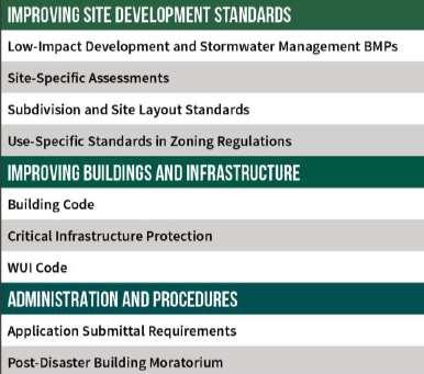
22 Model Code Language Integrating Risk Reduction into Comprehensive Plans Climate Plan Community Wildfire Protection Plan (CWPP) Hazard Mitigation Plan Parks and Open Space Plan Pre-Disaster Planning Community Rating System Development Agreements Transfer of Development Rights Density Bonuses 1041 Regulations Cluster Subdivisions Land Acquisition Overlay Zoning Stream Buffers and Setbacks Low-Impact Development and Stormwater Management BMPs Site-Specific Assessments Subdivision and Site Layout Standards Use-Specific Standards Building Code Critical Infrastructure Protection WUI Code Application Submittal Requirements Post-Disaster Building Moratorium

23 Model Code Language Language to be tailored for local governments (in blue) Based on several best practices throughout Colorado and the nation Includes commentary for further explanation (in margin)

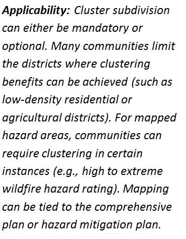
24 Case Study Cluster Subdivisions
25 Case Study Cluster Subdivisions SW County Big City Small Town Front Range Resort County

26 Appendix Hazards in Colorado Expanded information related to the hazards profiled in the guide. Each hazard includes: Description of the hazard Hazard risk in Colorado Related hazards Available data sources Summary of applicable planning tools and strategies

27


28 Goals of the Website Accommodate different user experiences Offer user-friendly interface Make it easy to access information from the printed guide Bring the document to life through enriched media Dynamic with new content over time JANE JIM JOHN
29 Jim s Scenario Interested in wildfire, Jim has some burning questions How does wildfire impact Colorado communities? What types of planning tools can address wildfire? What other hazards can be addressed with the same planning tool? Is there model code language for that planning tool?


30

31

32 Community Rating System Voluntary, incentive-based program that encourages community floodplain management activities that exceed minimum federal standards Provides a strong framework for implementing comprehensive flood risk management Flood insurance rates are discounted for ALL policyholders in the community based on creditable local activities 46 Colorado communities currently participate in CRS
 Total number of NFIP policies = 10")
 Key")

33 Community Rating System City of Delta Pop. = 8,652 (2014) Total number of NFIP policies = 10 Joined CRS in 1996, actively participating as Class 8 community (10% discount for floodplain properties) Key activities include: Open space preservation Drainage system maintenance Higher regulatory standards Public outreach activities

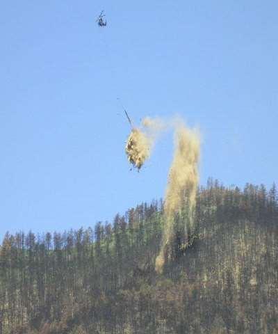
34 Critical Infrastructure Protection Erie Municipal Airport Major economic asset and opportunity for Town of Erie Critical transportation & lifeline facility Traverses Coal Creek floodplain Airport access limited to single bridge at Coal Creek Crossing Connects runway to maintenance facility, private hangars and several businesses Critical to proposed Airport Business Park
 funds Total project cost = $417,083 No damage or economic loss during September 2013 flood The structure worked per its design.")
35 Critical Infrastructure Protection Undersized, decaying culvert required frequent clearing and repairs just to keep operational in small storms In 2008, the Town replaced the culvert through the assistance of FEMA Pre-Disaster Mitigation (PDM) funds Total project cost = $417,083 No damage or economic loss during September 2013 flood The structure worked per its design. It s a great asset to the town and the airport. Russell Pennington Deputy Director of Public Works Town of Erie

36 Site-Specific Hazard Assessment Eagle County, Colorado Wildfire management requirements during planning procedures Sketch Plan Process Special Uses Subdivisions PUDs Requirements for building permits Site inspection process Used with permission: Eric Lovgren Wildfire Mitigation Manager
 Paying for the program (only charges a $200 wildfire mitigation")
37 Site-Specific Hazard Assessment Challenges in implementation Public acceptance takes time Competing interests such as natural forest views Second homeownership seasonal population Poor design of existing communities (lack of appropriate ingress/egress) Paying for the program (only charges a $200 wildfire mitigation fee)
38 Site-Specific Hazard Assessment Advantages and Key Talking Points (from the guide) The best (and in some cases the only) way to identify hazards on a site and determine the most effective methods for mitigation. Highlight potentially hazardous conditions prior to any development occurring. Provide an important educational component between staff and the applicant related to hazards. Results in reduced risk to property and life.
")
39 Subdivision and Site Design Standards Pagosa Springs, Colorado Sensitive Area Protection Standards Land Use and Development Code Slopes Natural features Areas of special flood hazard Geologic hazard areas Wildfire hazard areas Riparian setbacks Perimeter fencing (for wildlife migration)

40 Subdivision and Site Design Standards Pagosa Springs, Colorado Sensitive Area Protection Standards Example: Subdivisions in Geologic Hazard Areas must meet several conditions, including: Will not create undue financial burden on future residents or the community Structures designed for occupancy shall be constructed tot prevent risk to life or property Permitted land uses shall avoid or mitigate geologic hazards at initial construction


41 Video Interviews Enriched media content Real life examples of planning for hazards Description of tools
42 Planning for Hazards in Larimer County


43 Mitigating the Risks in Larimer County Fire and Flood

44 June 9, 2012 High Park Wildfire

45 Aerial Mulching Operation

46 On September 9, 2013 it started to rain

47 Colorado Largest Disaster September 2013 Flood September 11, 2013

48 Flood Statistics 10 People Died 18,000 Evacuated 1,882 Structures Destroyed 20 inches of rain in 7 days

49 Larimer County Planning Activities County Ordinances and Policies County Strategic Plan Hazard Mitigation Plan
50 Moving Forward/Next Steps

51 Putting the Guide into Action Use guide to inform community planning policies and procedures Use guide to support ongoing emergency management and mitigation efforts Use guide as an educational and outreach tool

52 Choosing Appropriate Planning Tools Ask the following questions when selecting tools and strategies: What hazards are you trying to mitigate? Do you have policies in place already? Do you have capacity to implement? Do you have community buy-in? Could you accomplish multiple goals with one tool?


53 Building the Case Thoughtful engagement Unified messaging Findings grounded in data Speak to elected officials early and often

54 Forming a Network Identify subject matter experts Find examples from other communities Develop best practices and additional resources Harness political leadership Recruit local champions
55 Additional Best Practices? Submit your ideas to:


56 Questions & Discussion

57 Thank You Anne Miller Lori Hodges Darrin Punchard Tareq Wafaie
SOUTH CENTRAL REGION MULTI-JURISDICTION HAZARD MITIGATION PLAN. Advisory Committee Meeting September 12, 2012
 SOUTH CENTRAL REGION MULTI-JURISDICTION HAZARD MITIGATION PLAN Advisory Committee Meeting September 12, 2012 AGENDA FOR TODAY Purpose of Meeting Engage All Advisory Committee Members Distribute Project
Use of FEMA Non regulatory Flood Risk Products in Planning
 Use of FEMA Non regulatory Flood Risk Products in Planning Georgia Association of Floodplain Managers Annual Conference March 24, 2016 What are the Non regulatory Flood Risk products? Go beyond the basic
Findings/Debrief Meeting September 9, CDOT R4 Headquarters Big Thompson Conference Room W 10 th St. Greeley, CO 80634
 Findings/Debrief Meeting September 9, 2016 CDOT R4 Headquarters Big Thompson Conference Room 10601 W 10 th St. Greeley, CO 80634 Discovery Review & Outcome May 25 Discovery Meeting Summary Summarize Data
MUNICIPAL LAND USE STRATEGIES for Improving Flood Resilience
 MUNICIPAL LAND USE STRATEGIES for Improving Flood Resilience Strategy for a Flood Resistant Southern Tier Central Region (LWRP project) This presentation was prepared by Southern Tier Central Regional
Town of Montrose Annex
 Town of Montrose Annex Community Profile The Town of Montrose is located in the Southwest quadrant of the County, east of the Town of Primrose, south of the Town of Verona, and west of the Town of Oregon.
Role of Disaster Insurance in Improving Resilience: An Expert Meeting The Resilient America Roundtable
 Role of Disaster Insurance in Improving Resilience: An Expert Meeting The Resilient America Roundtable National Academy of Science Washington, DC July 9, 2015 Roseville Demographics Primary population
G318 Local Mitigation Planning Workshop. Module 2: Risk Assessment. Visual 2.0
 G318 Local Mitigation Planning Workshop Module 2: Risk Assessment Visual 2.0 Unit 1 Risk Assessment Visual 2.1 Risk Assessment Process that collects information and assigns values to risks to: Identify
CWPPs, HMPs, NFIP, FIRM: MAKING SENSE OF THE HAZARD PLANNING ALPHABET SOUP
 CWPPs, HMPs, NFIP, FIRM: MAKING SENSE OF THE HAZARD PLANNING ALPHABET SOUP Presented By: Christopher Duerksen cduerksen@clarionassociates.com 303-830-2890 ROCKY MOUNTAIN LAND USE INSTITUTE MARCH 2015 OVERVIEW
C APABILITY A SSESSMENT
 PURPOSE The Rappahannock Rapidan region's capability assessment was conducted to determine the ability of participating localities to develop and implement a comprehensive hazard mitigation strategy and
Planning Process---Requirement 201.6(b): An open public involvement process is essential to the development of an effective plan.
: An open public involvement process is essential to the development of an effective plan.") Section 3 Capability Identification Requirements Planning Process---Requirement 201.6(b): An open public involvement process is essential to the development of an effective plan. Documentation of the Planning
Section 3 Capability Identification Requirements Planning Process---Requirement 201.6(b): An open public involvement process is essential to the development of an effective plan. Documentation of the Planning
CAPABILITY ASSESSMENT
 SECTION 7 CAPABILITY ASSESSMENT This section of the Plan discusses the capability of the communities in the Smoky Mountain Region to implement hazard mitigation activities. It consists of the following
Village of Blue Mounds Annex
 Village of Blue Mounds Annex Community Profile The Village of Blue Mounds is located in the southwest quadrant of the County, north of the town of Perry, west of the town of Springdale, and south of the
FLOODPLAIN MANAGEMENT PLAN 2015 ANNUAL PROGRESS REPORT
 FLOODPLAIN MANAGEMENT PLAN 2015 ANNUAL PROGRESS REPORT Hinds County (Unincorporated) NFIP Community Number 280070 The 2015 Floodplain Management Plan Annual Progress Report on the progress made in implementing
CITY OF PLANTATION ENGINEERING DEPARTMENT INTEROFFICE MEMORANDUM NO
 CITY OF PLANTATION ENGINEERING DEPARTMENT INTEROFFICE MEMORANDUM NO. 2013-003 DATE: October 22, 2012 TO: Mayor and Members of City Council FROM: Brett W. Butler, PE, CFM City Engineer SUBJECT: CRS Program
Justification for Floodplain Regulatory Standards in Illinois
 Justification for Floodplain Regulatory Standards in Illinois Office of Water Resources Issue Paper April, 2015 Proactive Illinois floodplain and floodway regulatory standards have prevented billions of
Michael Taylor, PE, CFM Project Manager, AECOM August 25, 2015
 Promoting FEMA s Flood Risk Products in the Lower Levisa Watershed Michael Taylor, PE, CFM Project Manager, AECOM August 25, 2015 Agenda Study Background Flood Risk Product Overview AOMI and Mitigation
Natural Hazards Mitigation Plan. Executive Summary
 Natural Hazards Mitigation Plan Executive Summary 1. Introduction Kane County Illinois, is subject to natural hazards that threaten life and health and have caused extensive property damage. Floods struck
HAZARD MITIGATION PLAN POINT OF CONTACT MUNICIPAL PROFILE
 HAZARD MITIGATION PLAN POINT OF CONTACT assistmanager@lowermilford.net publicworks@lowermilford.org MUNICIPAL PROFILE MUNICIPAL PARTICIPATION Compliance with the National Flood Insurance Program (NFIP)
HAZARD MITIGATION PLAN POINT OF CONTACT MUNICIPAL PROFILE
 HAZARD MITIGATION PLAN POINT OF CONTACT louise@windgap-pa.gov jeffreyyob@gmail.com MUNICIPAL PROFILE MUNICIPAL PARTICIPATION Compliance with the National Flood Insurance Program (NFIP) Identify source
BACKGROUND ANNUAL PROGRESS REPORT DEVELOPMENT ADOPTION OF THE H-GAC HAZARD MITIGATION PLAN/UPDATES MISSION STATEMENT
 BACKGROUND CITY OF CONROE FLOODPLAIN MANAGEMENT ANNUAL PROGRESS Activity 510 of the National Flood Insurance Program s (NFIP) Community Rating System (CRS) requires the development of a Floodplain Management
National Flood Insurance Program s Community Rating System:
 National Flood Insurance Program s Community Rating System: An Introduction and Discussion of the RDO Role: 1/2 Presentation - 1/2 Discussion Bill Lesser, Federal Insurance and Mitigation Administration,
Dade County Natural Hazard Mitigation Plan
 Introduction to Mitigation Definition of Mitigation Mitigation is defined by FEMA as "...sustained action that reduces or eliminates longterm risk to people and property from natural hazards and their
PUBLIC SURVEY FOR HAZARD MITIGATION PLANNING
 PUBLIC SURVEY FOR HAZARD MITIGATION PLANNING We need your help! The Counties of Cherokee, Graham, Haywood, Jackson, Swain, and the Eastern Band of Cherokee Indians are currently engaged in a planning process
ANNEX B: TOWN OF BLUE RIVER
 ANNEX B: TOWN OF BLUE RIVER B.1 Community Profile Figure B.1 shows a map of the Town of Blue River and its location within Summit County. Figure B.1. Map of Blue River Summit County (Blue River) Annex
Plan Maintenance Procedures
 PLAN MAINTENANCE PLAN MAINTENANCE PROCEDURES... 1 MONITORING AND EVALUATION... 2 PLAN MONITORING... 2 PLAN EVALUATION... 2 UPDATING... 2 PLAN AMENDMENTS... 2 FIVE (5) YEAR REVIEW... 3 INCORPORATION...
9/14/2012. Floodplain Basics the 100 year Flood. Columbus & Bartholomew County Flood Regulation Study Committee. Bartholomew County Floodplains
 Floodplain Basics the 100 year Flood Columbus & Bartholomew County Flood Regulation Study Committee 100-year Floodplain Purdue Land Use Team Video Seminar Series September 17, 2012 Floodway 1.2 inches
Delaware River Basin Commission s Role in Flood Loss Reduction Efforts
 Delaware River Basin Commission s Role in Flood Loss Reduction Efforts There is a strong need to reduce flood vulnerability and damages in the Delaware River Basin. This paper presents the ongoing role
HAZARD MITIGATION PLAN POINT OF CONTACT. MUNICIPAL PROFILE
 HAZARD MITIGATION PLAN POINT OF CONTACT washtwpemc@ptd.net MUNICIPAL PROFILE MUNICIPAL PARTICIPATION Compliance with the National Flood Insurance Program (NFIP) Topic 1. Staff Resources Is the Community
Floodplain Development Permits A Technical Guidance Document
 Floodplain Development Permits A Technical Guidance Document To Prevent Loss of Life, Reduce Property Damage and to Protect and Enhance the Natural and Beneficial Functions of Floodplains Iredell County
T-318. Hazard Mitigation Section TDEM Recovery, Mitigation, and Standards
 T-318 Local Hazard Mitigation Plan Requirements Hazard Mitigation Section TDEM Recovery, Mitigation, and Standards Raymond Mejia, Lead Hazard Mitigation Planner Samantha Aburto, Hazard Mitigation Planner
CHAPTER THREE Natural Hazard Mitigation Strategy
 CHAPTER THREE Natural Hazard Mitigation Strategy Chapter 3 Section All Sections Updates to Section Revised Natural Hazards Introduction and all Sections to change Natural Hazards Subcommittee to Committee.
SECTION 6 - RANGE OF ALTERNATIVE MITIGATION ACTIONS CONSIDERED
 SECTION 6 - RANGE OF ALTERNATIVE MITIGATION ACTIONS CONSIDERED For this hazard mitigation plan to be approved by FEMA, each participating jurisdiction was required to identify and analyze a comprehensive
New Jersey Department of Environmental Protection. Five-Year Floodplain Management Work Plan
 New Jersey Department of Environmental Protection Five-Year Floodplain Management Work Plan September 30, 2004 I. State Authority New Jersey Department of Environmental Protection Five-Year Floodplain
Sketch Plan Alternatives: Summary of Planning Commission and Board of Supervisors Recommendations
 HUMBOLDT COUNTY GENERAL PLAN UPDATE Sketch Plan Alternatives: Summary of Planning Commission and Board of Supervisors Recommendations September 2004 Prepared by Humboldt County Department of Community
HAZARD MITIGATION PLAN POINT OF CONTACT MUNICIPAL PROFILE
 HAZARD MITIGATION PLAN POINT OF CONTACT nazareth50em1@gmail.com jessicagteel@gmail.com MUNICIPAL PROFILE MUNICIPAL PARTICIPATION 3. Describe how the public will be engaged in the current planning process
City of Centerville BMP Pages Table of Contents. Minimum Control Measure 1. Public Education and Outreach
 i City of Centerville s Table of Contents Minimum Control Measure 1. Public Education and Outreach Best Management Practice Page 1-1: Outreach Publications...1 1-2: 30-day Public Notice for Annual Storm
Disaster resilient communities: Canada s insurers promote adaptation to the growing threat of high impact weather
 Disaster resilient communities: Canada s insurers promote adaptation to the growing threat of high impact weather by Paul Kovacs Executive Director, Institute for Catastrophic Loss Reduction Adjunct Research
PLANNING AND ZONING COMMISSION COMMUNICATION
 PLANNING AND ZONING COMMISSION COMMUNICATION City of Longmont, Colorado Project Title: Meeting Date: April 25, 2018 Land Development Code and Official Zoning Map Update Staff Planner: Brien Schumacher,
SECTION 9: MAPS AND DATA
 SECTION 9: MAPS AND DATA Contents 9.1. NFIP Maps and Data... 9-2 9.1.1. Adopting and enforcing NFIP floodplain maps and data... 9-2 9.1.2. Adopting and enforcing more restrictive data... 9-2 9.1.3. Annexations...
Community Incentives for Nature-Based Flood Solutions
 Community Incentives for Nature-Based Flood Solutions A GUIDE TO FEMA S COMMUNITY RATING SYSTEM FOR CONSERVATION PRACTITIONERS The Federal Emergency Management Agency (FEMA) uses a Community Rating System
Flood Hazards and Flood Risk, the Impact of a Changing Climate
 Flood Hazards and Flood Risk, the Impact of a Changing Climate Sally A. McConkey, P.E. CFM, D. WRE. Illinois State Water Survey June 14, 2017 Topics ISWS Coordinated Hazard Assessment and Mapping Program
HAZARD MITIGATION PLAN POINT OF CONTACT MUNICIPAL PROFILE
 HAZARD MITIGATION PLAN POINT OF CONTACT hankvb@entermail.net khorvath@kceinc.com MUNICIPAL PROFILE MUNICIPAL PARTICIPATION Compliance with the National Flood Insurance Program (NFIP) Topic 1. Staff Resources
Multi-Jurisdictional Hazard Mitigation Plan. Data Collection Questionnaire. For Local Governments
 Multi-Jurisdictional Hazard Mitigation Plan Data Collection Questionnaire County: For Local Governments Jurisdiction: Return to: Marcus Norden, Regional Planner BRP&EC Please complete this data collection
Pre-Development Floodplain Application
 Pre-Development Floodplain Application The Department of Planning, at the recommendation of FEMA, is now requiring completion of a Pre- Development Floodplain Application for all properties in the regulated
JUNEAU COUNTY ALL HAZARDS MITIGATION PLAN UPDATE. OVERSIGHT COMMITTEE KICK-OFF September 21, 2016
 JUNEAU COUNTY ALL HAZARDS MITIGATION PLAN UPDATE OVERSIGHT COMMITTEE KICK-OFF September 21, 2016 DARRYL L. LANDEAU, AICP SENIOR PLANNER NORTH CENTRAL WI REGIONAL PLANNING COMMISSION Past Work of NCWRPC
Floodplain Management Plan State of Utah
 Utah Department of Public Safety Division of Emergency Services Floodplain Management Plan State of Utah September 2004 Prepared by: Judy Watanabe Utah Division of Emergency Services State NFIP Coordinator
David A. Stroud, CFM AMEC Earth & Environmental Raleigh, NC
 David A. Stroud, CFM AMEC Earth & Environmental Raleigh, NC Objectives Risk MAP background North Carolina s Risk MAP role Role of communication in Risk MAP Effective risk communication two examples Multi-hazard
Hazard Mitigation FAQ
 Hazard Mitigation FAQ What is Hazard Mitigation? Actions taken to reduce or eliminate the long-term risk to people, property, or the environment from hazards and their effects. Examples: Hazardous Area
All Hazard All Discipline Minutes
 All Hazard All Discipline Minutes October 27, 2016 11:30 am Gallatin County Coordination Center Agenda Present Patrick Lonergan, Kerri Strasheim; Mary Martin; Sean O Callaghan, Graver Johnson, Don Wilson,
Simsbury. Challenges Capitol Region Natural Hazards Mitigation Plan Update - Page 356
 Simsbury Simsbury is a suburban community of about 23,600 located in the western portion of the Capitol Region. Its land area encompasses 33.9 square miles. Elevation in town generally ranges from about
Community Rating System. National Flood Insurance Program
 National Flood Insurance Program Community Rating System A Local Official s Guide to Saving Lives Preventing Property Damage Reducing the Cost of Flood Insurance FEMA B-573 / May 2015 How the Community
Flood Risk Outreach Tools for Georgia Communities. GAFM 10 th Annual Conference Presented By: Jarrett Mattli
 Flood Risk Outreach Tools for Georgia Communities GAFM 10 th Annual Conference Presented By: Jarrett Mattli April 13, 2016 Presentation Overview Guidebooks Toolkits Templates Educational Videos Resource
FREQUENTLY ASKED QUESTION ABOUT FLOODPLAINS Michigan Department of Environmental Quality
 FREQUENTLY ASKED QUESTION ABOUT FLOODPLAINS Michigan Department of Environmental Quality WHAT IS A FLOOD? The National Flood Insurance Program defines a flood as a general and temporary condition of partial
Changes in Criteria and Scoring for CRS Outreach Projects
 Changes in Criteria and Scoring for CRS Outreach Projects A Handout for the National Flood Insurance Program Community Rating System Many communities want to keep disseminating and obtaining CRS credit
Section 2. Introduction and Purpose of the LMS
 Section 2. Introduction and Purpose of the LMS 2.1 Introduction The Disaster Mitigation Act of 2000 (DMA 2000), signed into law by the President of the United States on October 30, 2000 (P.L. 106-390),
Truckloads (at 25 tons/truck) of building debris 90
 of building debris 90") Marlborough Marlborough is a rural community in Hartford County covering a land area of 23.3 square miles and with an estimated population of 6,410. Elevation ranges from about 160 to 800 feet. The Town
Marlborough Marlborough is a rural community in Hartford County covering a land area of 23.3 square miles and with an estimated population of 6,410. Elevation ranges from about 160 to 800 feet. The Town
HAZARD MITIGATION PLAN POINT OF CONTACT MUNICIPAL PROFILE
 HAZARD MITIGATION PLAN POINT OF CONTACT jmeyers75@ptd.net joshbingham@lehighcounty.org MUNICIPAL PROFILE MUNICIPAL PARTICIPATION Compliance with the National Flood Insurance Program (NFIP) Topic 1. Staff
2019 Budget Presentation Planning and Community Development. Craig Dossey, Executive Director October 18, 2018
 2019 Budget Presentation Planning and Community Development Craig Dossey, Executive Director October 18, 2018 Organizational Chart Executive Director Deputy Director Project Management/ Planning Group
Action Items for Flood Risk Management on Wildcat Creek Interagency success with floodplain management plans and flood forecast inundation maps
 Presentation to USACE 2012 Flood Risk Management and Silver Jackets Joint Workshop, Harrisburg, Pennsylvania Action Items for Flood Risk Management on Wildcat Creek Interagency success with floodplain
Dealing With Unnumbered A Zones in Maine Floodplain Management
 Dealing With Unnumbered A Zones in Maine Floodplain Management The following is a list of acceptable methods that the State Floodplain Management Coordinator and the Federal Emergency Management Agency
DeSoto Parish Hazard Mitigation Plan Update Kick-off Meeting. February 16, 2016 Grand Cane, LA
 DeSoto Parish Hazard Mitigation Plan Update Kick-off Meeting February 16, 2016 Grand Cane, LA Introductions Officials Mitigation Steering Committee members SDMI team members GOHSEP hazard mitigation team
Hillsborough County Local Mitigation Strategy and the Community Rating System
 Hillsborough County Local Mitigation Strategy and the Community Rating System Presented By Hillsborough County s Hazard Mitigation Section Eugene Henry, Manager Hazard Mitigation Contributing Team Members:
ASFPM Partnerships for Statewide Mitigation Actions. Alicia Williams GIS and HMP Section Manager, Amec Foster Wheeler June 2016
 ASFPM Partnerships for Statewide Mitigation Actions Alicia Williams GIS and HMP Section Manager, Amec Foster Wheeler June 2016 Summary The Concept Leveraging Existing Data and Partnerships to reduce risk
Planning Process---Requirement 201.6(b): An open public involvement process is essential to the development of an effective plan.
: An open public involvement process is essential to the development of an effective plan.") Section 3 Capability Identification Requirements Planning Process---Requirement 201.6(b): An open public involvement process is essential to the development of an effective plan. Documentation of the Planning
Section 3 Capability Identification Requirements Planning Process---Requirement 201.6(b): An open public involvement process is essential to the development of an effective plan. Documentation of the Planning
HAZARD MITIGATION PLAN POINT OF CONTACT MUNICIPAL PROFILE
 HAZARD MITIGATION PLAN POINT OF CONTACT lee.laubach@allentownpa.gov james.wehr@allentownpa.gov MUNICIPAL PROFILE MUNICIPAL PARTICIPATION Compliance with the National Flood Insurance Program (NFIP) 1. Staff
Integrating Hazard Mitigation into Local Planning to Support Community Resilience on the Mississippi Gulf Coast
 Integrating Hazard Mitigation into Local Planning to Support Community Resilience on the Mississippi Gulf Coast MASGP-13-020 This publication was supported by the U.S. Department of Commerce s National
HAZARD MITIGATION PLAN POINT OF CONTACT MUNICIPAL PROFILE
 HAZARD MITIGATION PLAN POINT OF CONTACT northcatasauquaema@yahoo.com scheirerg@gmail.com MUNICIPAL PROFILE MUNICIPAL PARTICIPATION Compliance with the National Flood Insurance Program (NFIP) Identify source
BUTTE COUNTY ZONING ORDINANCE CONTENTS
 BUTTE COUNTY ZONING ORDINANCE CONTENTS Part 1 Enactment and Applicability Article 1. Purpose and Effect of the Zoning Ordinance... 3 24-1 Title... 3 24-2 Purpose of the Zoning Ordinance... 3 24-3 Relationship
A Flood Mitigation Plan for the Non-Tidal N.J. Section of the Delaware River Basin. Warren County Planning Workshop (2 nd Meeting) March 7, 2007
 March 7, 2007") A Flood Mitigation Plan for the Non-Tidal N.J. Section of the Delaware River Basin Warren County Planning Workshop (2 nd Meeting) March 7, 2007 Study Area Participation: Hunterdon: 16 Eligible Municipalities
A Flood Mitigation Plan for the Non-Tidal N.J. Section of the Delaware River Basin Warren County Planning Workshop (2 nd Meeting) March 7, 2007 Study Area Participation: Hunterdon: 16 Eligible Municipalities
The National Flood Insurance Program Community Rating System: An Introduction and Discussion of the RDO Role. October 2, :00-3:15 pm ET
 The National Flood Insurance Program Community Rating System: An Introduction and Discussion of the RDO Role October 2, 2014 2:00-3:15 pm ET Our Mission The National Association of Development Organizations
Public Meeting 28 November Presented by: Deepa Srinivasan, Vision Planning and Consulting, LLC Dr. Michael Scott, ESRGC, Salisbury University
 Public Meeting 28 November 2016 Presented by: Deepa Srinivasan, Vision Planning and Consulting, LLC Dr. Michael Scott, ESRGC, Salisbury University To update the all-hazards mitigation plan and flood mitigation
Council Communication February 21, 2017, Business Meeting
 Council Communication February 21, 2017, Business Meeting Second Reading of an ordinance amending the Flood Plain Corridor Lands Map FROM: Bill Molnar, Director of Community Development, bill.molnar@ashland.or.us
FEMA FLOOD MAPS Public Works Department Stormwater Management Division March 6, 2018
 FEMA FLOOD MAPS Public Works Department Stormwater Management Division March 6, 2018 Presentation Overview FEMA National Flood Insurance Program (NFIP) FEMA Community Rating System (CRS) Flood Insurance
HAZARD MITIGATION PLAN POINT OF CONTACT. MUNICIPAL PROFILE
 HAZARD MITIGATION PLAN POINT OF CONTACT troseberry@easton-pa.gov cmanges@easton-pa.gov MUNICIPAL PROFILE MUNICIPAL PARTICIPATION Compliance with the National Flood Insurance Program (NFIP) Identify source
APPENDIX H TOWN OF FARMVILLE. Hazard Rankings. Status of Mitigation Actions. Building Permit Data. Future Land Use Map. Critical Facilities Map
 APPENDIX H TOWN OF FARMVILLE Hazard Rankings Status of Mitigation Actions Building Permit Data Future Land Use Map Critical Facilities Map Zone Maps Hazard Rankings (From Qualitative Assessment and Local
Bucks County, PA Flood Risk Review Meeting. November 2014
 Bucks County, PA Flood Risk Review Meeting November 2014 Agenda for Today Risk MAP Program overview Overview of non-regulatory Flood Risk Products and datasets Discuss mitigation action Technical overview
HAZARD MITIGATION PLAN POINT OF CONTACT MUNICIPAL PROFILE
 HAZARD MITIGATION PLAN POINT OF CONTACT susanlmbt@frontier.com jcoyle@carrollengineering.com MUNICIPAL PROFILE MUNICIPAL PARTICIPATION Compliance with the National Flood Insurance Program (NFIP) Identify
Floodplain Management 101. Mississippi Emergency Management Agency Floodplain Management Bureau
 Floodplain Management 101 Mississippi Emergency Management Agency Floodplain Management Bureau Stafford Act The Stafford Disaster Relief and Emergency Assistance Act (Stafford Act) (Public Law 100-707)
Urban Flooding in Illinois The Changing Face of Floods
 Urban Flooding in Illinois The Changing Face of Floods Chicago Albany Park Neighborhood June 2008 National Academies of Science Chicago, IL September 19, 2017 Welcome to Illinois Floods? Really? Illinois
ITEM 9 STAFF REPORT. TO: Mayor and City Council. FROM: Tom Welch, Interim Fire Chief. SUBJECT: City ofmill Valley All-Hazard Mitigation Plan
 STAFF REPORT TO: Mayor and City Council FROM: Tom Welch, Interim Fire Chief SUBJECT: City ofmill Valley DATE: March 2,2015 Approved for Forwarding: ~c.~~_ a es C. McCann, City Manager 1 Issue: Consideration
City of St. Augustine. Floodplain Management Higher Standards Information
 City of St. Augustine Floodplain Management Higher Standards Information There are different regulations that communities can use to help protect existing and future development and natural floodplain
2018 FMA Annual Conference in Reno, NV:
 Nevada Floodplain Management News V O L U M E INSIDE THIS ISSUE: Sustainability in 1 the Face of Change Community Rating System Workshop 2 CCRFCD Master Plan Update 3 Douglas Co. Stormwater Maintenance
Local Government Guide to Understanding the 2015 Florida Peril of Flood Act. Tampa Bay Regional Planning Council. June 2017
 Local Government Guide to Understanding the 2015 Florida Peril of Flood Act Tampa Bay Regional Planning Council June 2017 This report was funded, in part, through a grant agreement from the Florida Department
The Risk of Wildfires Is Growing
 PCI THOUGHT LEADERSHIP SERIES Plan. Prepare. Protect. The Risk of Wildfires Is Growing Follow us on Twitter Like us on Facebook Visit us at pciaa.net Copyright 2018 by the Property Casualty Insurers Association
Community Resilience & NFIP s Community Rating system
 Community Resilience & NFIP s Community Rating system Ajita Atreya Wharton Risk Management and Decision Processes Center University of Pennsylvania National Association of Counties (NACo) Session on Risk
Crediting Adaptation Strategies through the National Flood Insurance Program s Community Rating System Coordinator s Manual
 Crediting Adaptation Strategies through the National Flood Insurance Program s Community Rating System Coordinator s Manual W. Thomas Hawkins, Adjunct Faculty, University of Florida, Levin College of Law
Natural Hazards Mitigation Plan Kankakee County, Illinois Executive Summary
 1. Introduction Natural Hazards Mitigation Plan Kankakee County, Illinois Executive Summary Kankakee County is subject to natural hazards that threaten life, safety, health, and welfare and cause extensive
INTEGRATION OF THE LOCAL MITIGATION STRATEGY INTO THE LOCAL COMPREHENSIVE PLAN BAKER COUNTY PROFILE. Executive Summary
 Executive Summary The experiences of the 2004 Hurricane Season epitomize the importance of better integrating hazard mitigation activities into local comprehensive planning. Last fall, residents from all
Floodplain Management Plan
 Floodplain Management Plan CITY OF FORT WORTH TFMA 2016 Spring Conference March 10, 2016 Agenda 1. Fort Worth Higher Standards (NFIP & CRS) 2. Floodplain Management Plan Overview and Results 3. Project
HAZARD MITIGATION PLAN POINT OF CONTACT MUNICIPAL PROFILE
 HAZARD MITIGATION PLAN POINT OF CONTACT jmilot@hanovereng.com manager@eatwp.org MUNICIPAL PROFILE MUNICIPAL PARTICIPATION Identify source of information, if different Topic from the one listed 1. Staff
Flood Smart Communities
 Flood Smart Communities Stevie Adams, Freshwater Specialist, The Nature Conservancy Funding provided by NOAA Coastal Storms Program through Ohio Sea Grant To conserve the lands and waters on which all
BUTTS COUNTY, GEORGIA AND INCORPORATED AREAS
 BUTTS COUNTY, GEORGIA AND INCORPORATED AREAS Butts County Community Name Community Number BUTTS COUNTY (UNICORPORATED AREAS) 130518 FLOVILLA, CITY OF 130283 JACKSON, CITY OF 130222 JENKINSBURG, TOWN OF
Wildfire and Flood Hazards, Using GIS Tools to Assess Risk
 Wildfire and Flood Hazards, Using GIS Tools to Assess Risk Floodplain Management Association Conference, Rancho Mirage, CA September 2015 Thoughts To Keep In Mind What advantages are there in looking at
SECTION V THE LOCAL MITIGATION STRATEGY BLUEPRINT
 SECTION V THE LOCAL MITIGATION STRATEGY BLUEPRINT A. GUIDING MITIGATION PRINCIPLES The Local Mitigation Strategy (LMS) is Hillsborough County s program developed to reduce or eliminate all forms of losses
HAZARD MITIGATION PLAN POINT OF CONTACT MUNICIPAL PROFILE
 HAZARD MITIGATION PLAN POINT OF CONTACT manager@boroughoffreemansburg.org chief@boroughoffreemansburg.org MUNICIPAL PROFILE MUNICIPAL PARTICIPATION Compliance with the National Flood Insurance Program
9.4 VILLAGE OF CAMILLUS
 9.4 VILLAGE OF CAMILLUS This section presents the jurisdictional annex for the Village of Camillus. A.) HAZARD MITIGATION PLAN POINT OF CONTACT Primary Point of Contact Kurt Brunger, Mayor 37 Main Street,
Leveraging the Community Rating System for Climate Adaptation. Southeast and Caribbean Climate Community of Practice Webinar Series 23 March 2015
 Leveraging the Community Rating System for Climate Adaptation Southeast and Caribbean Climate Community of Practice Webinar Series 23 March 2015 Today s Speakers: Shana Jones, J.D., Carl Vinson Institute
Natural Hazards Risks in Kentucky. KAMM Regional Training
 Natural Hazards Risks in Kentucky KAMM Regional Training Floodplain 101 Kentucky has approximately 92,000 linear miles of streams and rivers Approximately 31,000 linear miles have mapped flood hazards
Location: Tampa, Florida March 6, 2013
 Discovery Meeting: West Florida Coastal Study Location: Tampa, Florida March 6, 2013 Agenda Introductions Why we are here Outline Risk MAP products and datasets Discovery Overview: Project scoping and
Implementing risk-based asset management strategies
 Implementing risk-based asset management strategies 2018. 04. 17 Disaster Resilience by Design The challenge for local governments The Challenge for Local Governments Landslides Debris Flows Wildfire Wind